© 2009 diana carolina alvira reyes - university of florida
TRANSCRIPT

1
CONSERVATION IMPLICATIONS OF LIVELIHOOD AND PARK INTERACTIONS
By
DIANA CAROLINA ALVIRA REYES
A DISSERTATION PRESENTED TO THE GRADUATE SCHOOL OF THE UNIVERSITY OF FLORIDA IN PARTIAL FULFILLMENT
OF THE REQUIREMENTS FOR THE DEGREE OF DOCTOR OF PHILOSOPHY
UNIVERSITY OF FLORIDA
2009

2
© 2009 Diana Carolina Alvira Reyes

3
To the people of El Chaco, Ecuador, and to Pablo, Simon and my family in Colombia

4
ACKNOWLEDGMENTS
This dissertation would not have been completed without the patience, support, and
encouragement of many helpful mentors and friends. I especially thank my outstanding mentor
and committee chair Karen Kainer for her unlimited patience, guidance, encouragement and,
critical reviews of my research and writings. Karen was always willing to help by giving me
advice, keeping me focused in my endeavors and encouraging me to finish this dissertation. I
would also like to thank my other supervisory committee members Peter Hildebrand, Marianne
Schmink, and Elena Bastidas for their support and constructive criticism of my work which
helped me accomplish my academic goals. I also want to thank Karen, Marianne and Elena for
their friendship, support and ample understanding of pursuing graduate education while
balancing other roles like motherhood or “dissertating while mothering.” Thanks to Dr.
Hildebrand, Maria and Annie for their hospitality and friendship. I also thank Ramon Littel for
his statistical advice and support during my graduate education at UF. I would also like to thank
Anthony Oliver-Smith, Bob Buschbacher, and Janaki Alavalapati for their contribution to my
academic formation. I owe special recognition to Jon Dain for “facilitating” my academic and
personal growth, for his friendship and for opening up my career path as facilitator. James Colee
in IFAS statistical department gave me useful statistical advice guidance, for which I am
grateful.
The pursuit of my doctoral degree was made possible by the financial support of research
assistantships through the School of Natural Resources and Environment, Tropical Conservation
and Development Program graduate fellowship and Gordon and Betty Moore graduate
scholarship for Tropical Forest Conservation and Amazon Conservation Leadership Initiative
(ACLI) at the University of Florida. The field research was funded by The Tropical Conservation
and Development Program, the School for Forest Resources and Conservation at the University

5
of Florida, the Gordon and Betty Moore Foundation, the Rufford Maurice Laing Foundation, the
MacArthur Foundation, and ICRAF-USAID Linkages Funds. I want to give special thanks to
Elena Bastidas for inviting me to participate in the project “Training and capacity building in
community-based conservation for institutions working in protected areas of Ecuador and
Colombia” of the Tropical Conservation and Development Program, University of Florida.
Through this project, I met wonderful Colombians and Ecuadorians, learned a lot form them and
went to Ecuador to develop this dissertation.
I give special thanks to the administrative staff at the Center for Latin American Studies
and the TCD Program. I particularly would like to mention Margarita Gandia, the late Myrna
Sulsona, Hanna Covert, Victoria Gomez de la Torre, Patricia Sampaio and Wanda Carter. The
School of Natural Resources and Environment provided invaluable support through my PhD, and
I give sincere thanks to the assistance of Dr. Humphrey, Cathy Ritchie, and Meisha Wade. I want
to thank Winnie Lante and Cheri Arias in the School of Forest Resources and Conservation for
their assistance. I also want to give express my appreciation to Ann Moore, Tony Menella and
Karen Costner at the UF Infirmary for caring and solving all my health problems especially in
the last months of writing this dissertation.
I especially want to express my gratitude to the people at El Chaco, for opening up their
homes and sharing their time and wisdom. Thanks are due to guide and research assistant Wilson
Pinta, and collaborators in the field: Jorge Condor, Josue Chicaiza and Vladimir Torres. I thank
RECAY and PNSNG staff, Sumaco project staff, the youth group from the Telecommunication
Center, and the local government of El Chaco for their valuable participation, engagement and
collaboration in this research. I also thank Fundación EcoCiencia staff for their support and
collaboration and opening the doors to be able to develop this research at El Chaco. Especially at

6
EcoCiencia, I thank Rossana Manosalvas, Alex Rivas, Ivonne Muñoz, Jaime Camacho and their
families for their friendship and hospitality. At El Chaco, I also want to thank El Coyote, Isabel,
Violeta and William for their friendship and making us feel at home.
I am also thankful to Natalia Hoyos for elaborating the figures and maps for this
dissertation, and to Amy Duchelle, Marina Londres, Vivian Zuideman, Cara Rockwell, Christie
Klimas, Marlene Soriano, and Joanna Tucker from the Tropical Forestry graduate student
working group for their valuable comments on my manuscripts, friendship and camaraderie.
Special and warm thanks to Amycita for being always there with a smile, encouraging mood and
constructive criticism. Thanks also to Amy Duchelle and Simone Athayde my “superpoderosas”
mates for their friendship and support.
I want to give special thanks and appreciation to many friends in Gainesville, I want to
start mentioning my compañerito Alfredo Ríos with whom I started my Ph.D and shared a great
telecommunications closet and many great talks and moments drinking tintico. Franklin Paniagua
my other compañerito provided fantastic insights, gossip and taught me a lot about
“nemotecnic” staff. Alicia Peón, Rafael Rojas, Omaira Bolaños and Jaime Escobar and Natalia
Hoyos not only gave me their friendship, they let me use their homes, so I could escape and have
my own space to write and finish this dissertation, and I am deeply thankful to them. Silvia,
Nacho and Leon; Jaime, Nati and Antonia; Rafita, Edith and Aranza, Rodrigo, Tracy and Sofia;
Antonio, Rossana and Paulinho; Pati, Emilio and Diego; John, Christine and Beatriz, Los parces:
Sergio, Ysa, Inti and Luna; Manuel, Victoria and los chinos; Galo, Claudia, Maria Emilia and
Juan Diego; Tomás, Carolina and Marcellita; Pilar, Rob and Sofia have been our wonderful sister
families with whom we shared marvelous parties, novenas, and asados as we watched our little
ones grow up. I also want to thank Leo Martinez, Wendy-Lin Bartels, Linn Cassidy, Amy

7
Sullivan, Victor Cabrera, Geraldo Silva, Valerio Gomez, Noemi Porro, Hannah Covert, Cynthia
Gomez, Hollie Hall and Jordan Mayor for their support and friendship during my stay in
Gainesville.
The process of earning my PhD was longer and more laborious than I had anticipated. My
family and friends have often felt neglected and abandoned, but their love, patience, and support
have always been a great source of emotional support, without which I could not have
persevered. I sincerely thank them for their faith in me. I want to thank my father Fernando
Alvira who is not longer with us, for supporting and encouraging me to travel and look for
adventures and life lessons. My mother Gloria Reyes deserves special recognition for taking the
risk of going with me to El Chaco to take care of me during the first months of my pregnancy
and to be my field assistant. I am totally indebted to her and will never forget the wonderful
bonding time we had in Ecuador. During the process of this dissertation, my family grew, and we
were blessed with the marvelous presence of Simon. He enlightens our lives and reminds us what
is really important in life. I want to thank him for his patience and encouragement, especially in
the final stages of writing this dissertation in which every night he made sure that I had made
some progress by asking “ya acabaste?.” Finally, I would not have been able to carry out this
study and would not have been able to take care of Simon without the love, support, patience,
and fantastic company of Pablo, who excels at the roles of husband, father and housekeeper.
Unfortunately, at the end of writing this dissertation we lost Tamarindo, and I want to thank him
for giving us seven years of happiness, friendship and agradable compañía.

8
TABLE OF CONTENTS page
ACKNOWLEDGMENTS.................................................................................................................... 4
LIST OF TABLES.............................................................................................................................. 11
LIST OF FIGURES ............................................................................................................................ 13
ABSTRACT ........................................................................................................................................ 14
CHAPTER
1 INTRODUCTION....................................................................................................................... 16
Forests Frontiers and Biodiversity Conservation ...................................................................... 16 Beyond Protected Area Boundaries for Effective Biodiversity Conservation ........................ 17 Linking Protected Areas and Smallholder Farms in Northeastern Ecuador ............................ 18
2 SUSTAINABLE INNOVATIONS AND FOREST PERSISTENCE AMIDST PREDICTABLE TROPICAL FRONTIER DEFORESTATION ............................................ 22
Introduction ................................................................................................................................. 22 Patterns of Frontier Development ....................................................................................... 23 Sustainable Innovations and Innovators ............................................................................. 25
Study Site ..................................................................................................................................... 27 Methods ....................................................................................................................................... 28
Livelihood System Patterns and Forest Persistence .......................................................... 28 Sustainable Innovators and Innovations ............................................................................. 31
Results .......................................................................................................................................... 32 Emerging Patterns of Livelihood Systems ......................................................................... 32
Settlement patterns and land tenure ............................................................................ 32 Economic activities and resultant land uses ............................................................... 33
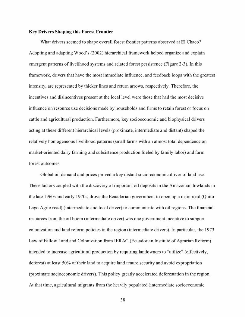
Explaining Forest Persistence ............................................................................................. 37 Key Drivers Shaping this Forest Frontier .......................................................................... 38 Sustainable Innovators and Innovations ............................................................................. 41
Soil, water and forest resource sustainable management .......................................... 41 Enhancing dairy production and ecological sustainability ........................................ 41 Promotion of local resources and production systems with income generation ...... 41 Social innovations ........................................................................................................ 42
Discussion .................................................................................................................................... 43 Roads and Predictable Deforestation.................................................................................. 44 Rural-Urban Interface .......................................................................................................... 45 Implications of Cattle Husbandry ....................................................................................... 46 Some Forests Persist ............................................................................................................ 48 Prevalence of Forest Cover Types ...................................................................................... 49 Sustainable Innovators and Innovations ............................................................................. 51

9
Origins of innovations.................................................................................................. 51 Innovations that bucked deforestation trends ............................................................. 55
Conclusions ................................................................................................................................. 56
3 PROTECTED AREA-COMMUNITY RELATIONS MATTER: INFLUENCES ON CONSERVATION PERFORMANCE IN NEIGHBORING COMMUNITIES .................... 64
Beyond Protected Area Boundaries ........................................................................................... 64 Study Site ..................................................................................................................................... 66 Physical Context .......................................................................................................................... 67 Methods ....................................................................................................................................... 68
Document Review ............................................................................................................... 69 Semi-structured Interviews ................................................................................................. 70 Cadastral Census .................................................................................................................. 70
Results .......................................................................................................................................... 72 Protected Area-Community Relations................................................................................ 72
Protected area establishment history and current management models ................... 72 Community interactions with protected area staff ..................................................... 75 Community awareness of protected areas .................................................................. 79 Perceived local benefits and costs of protected areas ................................................ 80
Conservation Performance in Neighboring Communities: Indicators of PA Effectiveness?................................................................................................................... 81
Sustainability-oriented activities ................................................................................. 82 Forest persistence on local farms ................................................................................ 84 Respect for protected area borders .............................................................................. 86
Discussion .................................................................................................................................... 87 Conservation Performance in Neighboring Communities and Protected Area
Success.............................................................................................................................. 87 Sustainability-oriented activities ................................................................................. 87 Forest persistence on local farms ................................................................................ 90 Respect for protected area borders .............................................................................. 91
Protected Area-Community Relations and Conservation Performance ........................... 93 Factors that Shaped Protected Area-Community Relations .............................................. 95 Implications for Protected Area Managers ........................................................................ 99
4 CONCLUSIONS ....................................................................................................................... 115
Main Research Findings ........................................................................................................... 115 Analysis of Research Process ................................................................................................... 120
Achievements ..................................................................................................................... 122 Conflictive Factors............................................................................................................. 122 Success Factors .................................................................................................................. 123 Ways Forward in El Chaco ............................................................................................... 124

10
APPENDIX
A HOUSEHOLD QUESTIONNAIRE ........................................................................................ 126
Household Interview Questionnaire......................................................................................... 126 Guidelines for Participatory Mapping-Mapa Parlante ........................................................... 128
B PROTECTED AREA QUESTIONNAIRES ........................................................................... 129
Cuestionario Director de Area RECAY................................................................................... 129 Cuestionario Director de Area PNSNG ................................................................................... 130 Cuestionario Guarda Parques ................................................................................................... 132 Cuestionario Finquero ............................................................................................................... 133 Cuestionario Alcalde, Concejales, Técnicos UMDS .............................................................. 134 Cuestionario Director Proyecto Gran Sumaco ........................................................................ 135
C PHOTOS DEPICTING METHOLOGIES AND ACTIVITIES DEVELOPED DURING RESEARCH .............................................................................................................................. 137
LIST OF REFERENCES ................................................................................................................. 143
BIOGRAPHICAL SKETCH ........................................................................................................... 156

11
LIST OF TABLES
Table page 2-1 Descriptive statistics for farm context and land use outcomes for all farms and
differentiating for farms with road access and remote farms at El Chaco Municipality in the year 2005-2006.. .......................................................................................................... 60
2-2 Results of the generalized linear model to identify the most important measured variables that explained forest persistence on farms at the Municipality of El Chaco in the year 2005-2006. ........................................................................................................... 61
2-3 Parameter estimates for forest persistence on local farms at the Municipality of El Chaco in the year 2005-2006. ................................................................................................ 62
2-4 Least squared means for forest persistence of an average-size farm at El Chaco municipality in the year 2005-2006. ..................................................................................... 62
2-5 Sustainable Innovations at El Chaco. .................................................................................... 63
3-1 General comparison between Cayambe Coca Ecological Reserve (RECAY) and Sumaco-Napo-Galeras National Park (PNSNG)................................................................ 104
3-2 Timeline of main events leading to the establishment of Cayambe-Coca Ecological Reserve (RECAY) with particular emphasis of El Chaco municipality. .......................... 105
3-3 Timeline of main events leading to the establishment of Sumaco Napo Galeras National Park (PNSNG) with particular emphasis of El Chaco municipality. ................ 106
3-4 Contrasting park management models between RECAY-lower zone and PNSNG-western region in the Municipality of El Chaco in the year 2005-2006. ......................... 107
3-5 Summary of community interactions with protected area staff, their awareness of the protected areas (PAs) and their perceptions of PA costs and benefits. ............................. 108
3-6 Sustainability-oriented activities influenced by RECAY and PNSNG and carried out in El Chaco communities in 2005-2006. ............................................................................ 110
3-7 Descriptive statistics for farm context, land use outcomes and market and road infrastructure variables of PNSNG farms and RECAY farms at El Chaco Municipality in the year 2005-2006. ................................................................................... 111
3-8 Bivariate correlation coefficients (Pearson correlation) between distances related variables. El Chaco Municipality, 2005-2006. ................................................................... 112
3-9 Principal components analysis (PCA) loading table to generate a composite factor for distance variables at El Chaco municipality. ...................................................................... 112

12
3-10 Results of the generalized linear model which identified the most important measured variables that explained forest persistence on farms adjacent to RECAY and PNSNG in the Municipality of El Chaco in the year 2005-2006. .............................. 113
3-11 Parameter estimates for forest persistence on farms adjacent to RECAY and PNSNG in the Municipality of El Chaco in the year 2005-2006. ................................................... 113
3-12 Least squared means for forest persistence of an average-sized farm and differentiating for farms adjacent to RECAY and PNSNG, and on the border of the protected area and non-at the border of the protected area ................................................ 114
3-13 Least squared means for forest persistence of an average-sized farm adjacent to RECAY and PNSNG, and also distinguishing for all farms at protected area border, and farms non at protected area border ............................................................................... 114

13
LIST OF FIGURES
Figure page 1-1 Location of El Condor Bioreserve in North Eastern Ecuador. ............................................ 21
2-1 Location of El Chaco municipality in northeastern Ecuador. ............................................. 57
2-2 Percentage farm area under different categories of land use for all farms differentiating for farms with road access and remote farms at El Chaco Municipality in the year 2005-2006. ........................................................................................................... 58
2-3 Framework for understanding the complexity of drivers that shaped the forest frontier of El Chaco in the Ecuadorian Amazon. ................................................................. 59
3-1 Location of El Chaco municipality within the Condor Bioreserve in North Eastern Ecuador. ................................................................................................................................ 101
3-2 Framework for understanding factors that shape protected area community relations and how these relations influence conservation performance in neighboring communities. ........................................................................................................................ 102
3-3 Percentages of land under different land uses for an average-sized farm located at RECAYand PNSNG at El Chaco municipality in the year 2005-2006.. .......................... 103
C-1 A one-week rapid reconnaissance of all five study parishes in the municipality of El Chaco .................................................................................................................................... 137
C-2 Participatory workshops at different parishes .................................................................... 138
C-3 Farms visits ........................................................................................................................... 139
C-4 Transplanting seedlings from forest to tree nurseries. ....................................................... 140
C-5 First fair of native plants ...................................................................................................... 140
C-6 Knowledge exchange visits ................................................................................................. 141
C-7 Reinvigoration of the farmer’s market. ............................................................................... 142

14
Abstract of Dissertation Presented to the Graduate School of the University of Florida in Partial Fulfillment of the Requirements for the Degree of Doctor of Philosophy
CONSERVATION IMPLICATIONS OF LIVELIHOOD AND PARK INTERACTIONS
By
Diana Carolina Alvira Reyes
August 2009 Chair: Karen Kainer Major: Interdisciplinary Ecology
Deforestation associated with colonization of forested frontiers represents a significant
threat to tropical biodiversity, and establishment of protected areas (PAs) has been an important
conservation strategy to counter this threat. PAs, however, are not isolated, but rather embedded
in larger landscapes of human influence. Thus, PA management should focus not only on
implementing conservation strategies within boundaries, but also consider issues across PA
borders that affect park integrity such as inter-related livelihood patterns, resource use, and forest
persistence in neighboring settlements.
I selected the frontier at El Chaco municipality in the northeastern Ecuadorian Amazon to
explore patterns and drivers of frontier development, the effect of multi-scalar biophysical and
socioeconomic factors on forest persistence on frontier farms, and sustainable innovators and
innovations that may counter deforestation patterns. I also compared PA-community relations
between two regional protected areas [Cayambe Coca Ecological Reserve (RECAY) and
Sumaco Napo Galeras National Park (PNSNG)] and their respective neighboring communities to
explore whether those relations were linked to conservation performance in these communities.
Both socioeconomic and biophysical drivers at multiple scales have, over time, shaped
relatively homogenous El Chaco livelihood patterns of small farms with a dependence on

15
market-oriented dairy farming and subsistence production fueled by family labor, but with
differential proportions and types of forest cover. The comparative analysis of PA-community
relations suggests that of the three indicators examined, sustainability-oriented activities and
respect for protected area borders may have been directly influenced by PA-community
relations, while forest persistence on farms appeared to be driven more by road access, farm size
and possibly time since colonization than PA-community relations. Although higher levels of
forest persistence were observed on PNSNG than RECAY border farms, seemingly related to
clearer boundary demarcation and better community relations under PNSNG staff leadership, all
border farmers expressed a clear intent to convert their forests to more lucrative uses when the
opportunity arose. Finally, despite pervasive road construction and clearing for cattle, I observed
sustainable innovators and innovations that challenged the clear deforestation trend at El Chaco,
developing ways to learn jointly and improve natural resource management strategies that
support sustainable development at forest frontier regions.
16
CHAPTER 1 INTRODUCTION
Forests Frontiers and Biodiversity Conservation
Forest frontiers are contentious regions under pressure to satisfy diverse and often
opposing conservation and development desires. These regions are conservation rich because
they have been isolated and sparsely populated. They are also, however, viewed as vast,
untapped areas that could contribute to national and regional development. Governments target
these regions for settlement by colonists and other entrepreneurs in search of land and income.
For these local stakeholders conserving natural resources is typically of secondary importance to
opening a rural property to support a family or business (Pichón, 1996; Brondizio et al., 2002).
Land conversion from forests to agricultural uses in association with the colonization of these
forest frontiers has historically represented one of the most significant threats to biodiversity in
Tropical America (Sayer, 1991; Brandon et al., 1998). The establishment of protected areas
(PAs) in forest frontiers has been the foundation of conservation strategies in response to
colonist-driven forest conversion and fragmentation (Brandon et al., 1998; Terborgh and van
Schaik, 2002).
Nonetheless, forest frontier development is much more nuanced than suggested by a
conservation versus development dichotomy. Frontier trajectories are shaped by multiple drivers
(socio-economic and biophysical), interacting at different scales and varying intensities over
time, and several scholars have developed analytical frameworks that integrate spatial and
temporal perspectives to better understand the diverse conditions that shape forest frontiers in
Amazonian regions (Browder and Godfrey, 1997; Pichón, 1997; McCracken et al., 2002; Perz
and Walker, 2002; Wood, 2002; Pacheco, 2005). In general terms, the main factors influencing
frontier development are primarily linked to government policy decisions about opening a

17
frontier for a particular interest (i.e. mineral, oil or timber exploration; relieve population
pressures from other regions, promoting the occupation of territories for establishing sovereignty
and national security). This process of frontier development is accompanied by road construction
(to provide access to the region), establishment of urban centers (boom towns), land distribution
policies (i.e. spontaneous or planned), along with incentive policies (i.e. credit for agricultural
activities, tax credits, legalization of land titling) (Pacheco, 2005).
Beyond Protected Area Boundaries for Effective Biodiversity Conservation
Increasingly biodiversity is discussed in terms of large-scale ecological processes and the
intensifying human driving forces behind its loss These human demographic, social, cultural and
economic trends are not seen as external to ecosystems, but as part of them (Saunders et al.,
1991). Therefore, several conservation approaches like the “functional landscape” developed by
The Nature Conservancy (Poiani et al., 2000), and the “living landscapes program” developed by
the Wildlife Conservation Society (Vedder et al., 2001), advocate the need to conserve dynamic,
multiscale ecological patterns and processes that sustain the biotic component and its supporting
system. This new perspective supplanted earlier the emphases on setting aside PAs. Protected
areas, however, are not isolated; they are embedded in larger landscapes of human influence and
can be threatened by forest loss and fragmentation occurring on adjacent lands (Laurance and
Bierregaard, 1997). Thus, to maintain a protected area’s ecological integrity, PA management
should focus not only on implementing strategies within boundaries, but also consider issues of
landscape connectivity, larger-scale ecological processes, human-resource uses, and wildlife that
extend across these borders (Vedder et al., 2001; Parrish et al., 2003). In addition, approaches
that go beyond park boundaries to engage regional government, non-governmental organizations
and neighboring communities, can strengthen the very institutions created to manage the
protected area (Mugisha and Jacobson, 2004; Bawa et al., 2007). These partnering activities

18
should be strategic, considering where and how human activities conflict with biodiversity
conservation, where conservation negatively impacts human welfare, and where there may be
mutual benefits (Wells and Brandon, 1992; Redford and Fern, 2007).
Over the last two decades, scholars and practitioners alike have examined diverse
partnering strategies for “conserving” beyond park boundaries (Wells and Brandon, 1992;
McShane and Wells, 2004). In particular, it has been found that greater focus on relationship
building with neighboring communities, as well as ensuring adequate alternatives to resource
exploitation within and outside the PA, could enhance the potential for achieving PA objectives
(Dudley et al., 2004; Stern 2008a,b). Therefore, it is necessary to understand the different
livelihood systems of rural populations living in and around PAs, their influence on natural
resource conservation on the ground, and then build on local practices that could support
biodiversity conservation while maintaining these rural livelihoods (Bawa et al., 2007).
Linking Protected Areas and Smallholder Farms in Northeastern Ecuador
The Condor Bioreserve (CBR) in the Ecuadorian Amazon represents an innovative
conservation approach that links seven protected areas, their buffer zones, and the intervening
smallholder farms under one management unit (Figure 1-1) (Benítez, 2003). Conservation at
such a large scale is more effective at safeguarding dynamic, multiscale ecological patterns and
processes. This type of functional landscape approach recognizes the ecological significance of
the smallholder farms sandwiched between core CBR protected areas; seeks biophysical linkages
via ecological corridors, and supports species movement and natural processes (Poiani et al.,
2000; Salafsky and Wollenberg, 2000). Just as intriguing, this approach anticipates the critical
importance of socio-economic linkages between core-protected areas and the local smallholders,
addressing the long-term sustainability of these units.

19
A mosaic of forest patches and fields dominate the intervening spaces between the five
protected areas that form Ecuador’s Condor Bioreserve. Ultimately, the conservation success of
this larger management unit (versus five disparate protected areas) hinges on the forests found in
these intervening spaces. As Schelhas (1994) observed, land use in the intervening spaces
between protected areas can make or break the conservation value of the single, larger unit.
The CBR covers more than 21,000 km2 and is located between 400 and 5,810 m in the
northeastern Andes mountain ranges of Ecuador. The areas under this unit comprise the upper
watershed of the Napo River, one of the main tributaries of the Amazon. The protected areas that
form part of the CBR, are Cayambe-Coca Ecological Reserve, Antisana Ecological Reserve,
Cofán-Bermejo Ecological Reserve, Pasochoa Wildlife Reserve, Cotopaxi National Park,
Llanganates National Park and Sumaco-Napo-Galeras National Park, which is the core of the
Sumaco UNESCO Biosphere Reserve (Figure 1-1). The CBR is one of the most biologically
diverse places in South America (Myers et al., 2000), with more than 760 bird species, 150
mammal species and 120 amphibian species have been documented (Benítez, 2003; TNC, 2007).
Although the CBR still has large tracts of natural habitat, it faces significant threats. These
are habitat conversion to agriculture or pastures, infrastructure projects being built inside the
protected areas (especially water extraction projects and roads), logging, hunting, fire, and
construction of oil pipelines (Ulfelder et al., 1997; Benítez, 2003; TNC, 2007). Communities
living in the CBR range from traditional peasant communities on the highlands to recently-
arrived colonists living in the lower part of the CBR, to three ancestral communities -Oyacachi,
Sinangué, and Cofán- whose territories are within some of the protected areas of the CBR.
Approximately 20% of the Ecuadorian population depends on environmental services and

20
natural resources from this area, because the Cayambe-Coca and Antisana Ecological Reserves
provide water to Quito, the capital city (Benítez, 2003; TNC, 2007).
The aim of this research was to understand the conservation implications of having a
variety of livelihood systems in the intervening spaces of protected areas in the Ecuadorian
Amazon. The field component of this research was executed on the lowland zone of the of the
Cayambe-Coca Ecological Reserve (RECAY) and western zone of Sumaco-Napo Galeras
National Park (PNSNG) in the north-eastern region of the Condor Bioreserve (Figure 1-1). The
study site is part of the municipality of El Chaco in the Napo Province. I selected El Chaco
municipality in the northeastern Ecuadorian Amazon as a focal study region because established
protected areas have largely closed this forest frontier, and colonists have had some time to adapt
to their new environment.
This dissertation has been organized such that the second and third chapters are two
individual and fully structured papers. Chapter two to explores the patterns and drivers of this
tropical forest frontier development, the effect of multi-scalar biophysical and socioeconomic
factors on forest persistence in this region, and sustainable innovators and innovations that may
counter deforestation patterns. Chapter three presents a comparative analysis of PA-community
relations between Cayambe Coca Ecological Reserve (RECAY) and Sumaco Napo Galeras
National Park (PNSNG) and their respective neighboring communities. It also explores whether
those relations were linked to conservation performance in neighboring communities in terms of
sustainability–oriented activities, forest persistence on local farms, and respect for protected area
boundaries. Chapter four summarizes the main findings of the entire study and presents a brief
description and analysis of the research process.

21
Figure 1-1..Location of El Condor Bioreserve in North Eastern Ecuador. The Ecuadorian map depicting the Condor Bioreserve (group of small forest “islands”) was adapted from an original obtained from the Condor Bioreserve Environmental and Geographic Study Map Collection (www.mapasbrc.org).
.

22
CHAPTER 2 SUSTAINABLE INNOVATIONS AND FOREST PERSISTENCE AMIDST PREDICTABLE
TROPICAL FRONTIER DEFORESTATION
Introduction
Tropical forest frontiers are contentious regions under pressure to satisfy diverse and often
opposing conservation and development desires. They are conservation rich because they have
been historically isolated and sparsely populated. They are also, however, viewed as vast,
untapped areas that could contribute to national and regional development. Governments
encourage development of these regions via subsidized credit, regional fiscal incentives,
differential taxation, and a series of other policies that typically encourage forest clearing and
“productive” (non-forest) land uses (Wood, 2002; Pacheco, 2005; Mena et al., 2006). These
policies target colonists and other entrepreneurs in search of land and income. For these local
stakeholders conserving natural resources is typically of secondary importance to opening a rural
property to support a family or business (Pichón, 1996; Brondizio et al., 2002). On the other
hand, in response to colonist- and firm-driven forest conversion and fragmentation, international
conservation groups pressure governments to establish protected areas in forest frontiers
(Brandon et al., 1998; Terborgh and van Schaik, 2002). This stark conflict between conservation
and colonization processes in forest frontiers is a well-documented global phenomenon (Hecht
and Cockburn, 1989; Schmink and Wood, 1992). Nonetheless, forest frontier development is
much more nuanced than suggested by a conservation versus development dichotomy. Frontier
trajectories are shaped by multiple socio-economic and biophysical drivers (Wood, 2002),
interacting at different geographic scales (Wood, 2002; Mena et al., 2006) and at varying
intensities over time (McCracken et al., 2002; Perz and Walker, 2002). While these frontier-
shaping conditions are diverse, complex, and dynamic, patterns do emerge that underlie the

23
spatial organization, resource use, and socioeconomic pathways in any given frontier (Pichón,
1997; Pacheco, 2005)
Patterns of Frontier Development
In general terms, the main factors influencing frontier development are primarily linked to
government policy decisions to open a frontier for a particular interest (i.e. mineral, oil or timber
exploration; relieve population pressures from other regions, or promoting the occupation of
territories for establishing sovereignty and national security). These interests orient the character
of the resultant frontier toward settlement and/or extraction (Friedman, 1996). Settlement
frontiers are characterized by colonist farmers who migrate with their families from established
regions of a nation to sparsely populated margins in search of land and income. In the early
(most forest-demanding) stages of settlement frontiers, continued in-migration increases
population densities and induces farmland expansion into these previously forested regions. As
settlement processes progress, migrant-family farms are subdivided (parcelized), soil fertility
declines, and rates of deforestation often rise sharply (Pan and Bilsborrow, 2005). This is
particularly true in closed frontier environments such as the northeastern Ecuadorian Amazon,
where parcelization accompanies a reduction in farm size and a decrease of forested area per
farm (Pichón et al., 2002; Mena et al.; 2006). In contrast, extractive frontiers do not generally
involve permanent rural settlement, and are penetrated primarily to extract minerals, fuel, or
timber for export to industrial regions and nations. Thus, purely extractive frontiers remain
sparsely populated (Friedman, 1996), although if additional opportunities exist (i.e. land for
farming and potential accessibility to markets), these extractive frontiers could take the pathway
of a settlement frontier.
Within settlement and extractive frontiers, the intermixing of two socioeconomic groups
lends greater specificity to a frontier region, further determining socioeconomic trajectory and

24
resource use. In their analysis of the Brazilian Amazon frontier, Browder and Godfrey (1997)
termed these groups populist and corporatist, while Pacheco (2005) similarly identified populist
and capitalist frontiers. Populist frontier groups are characterized by smallholder farmers,
independent miners, petty merchants, and others engaged in various forms of labor intensive
activity. In contrast, corporatist groups are dominated by capitalized enterprises pursuing
activities such as cattle ranching, agribusiness, large-scale resource extraction, such as timber
industries, and mining. Frontiers in which populist groups dominate tend to be more socio-
economically equitable and promote more complex land-use trajectories and land-use systems.
The corporatist dominated frontiers, however, typically concentrate landholdings and ownership,
and tend to induce large-scale deforestation with little forest succession (Browder and Godfrey
1997). Pacheco (2005) demonstrated that the distinction between a populist- and a capitalist-
dominated frontier is important, because who wins access to land and forest resources has
important implications for the way in which such resources are used, the distribution of the
economic benefits resultant from the land appropriation, and the transformation of natural
resources in the evolving frontiers.
Regardless of dominant processes or socioeconomic groups, all frontier development is
accompanied by roads. Roads are widely described as one of the most important predictors of
frontier expansion, spatial distribution and deforestation in tropical forest frontiers, across a
range of land dynamics (Chomitz and Gray, 1996; Kaimowitz and Angelsen, 1998). Road
opening first provides access to previously inaccessible and often unclaimed land and forests,
promoting migration and the establishment of farms and new villages in frontier regions. These
same roads facilitate movement in the opposite direction, connecting newly established regions
to other parts of the country, and linking people with urban centers (that provide health services,

25
electricity, communication services, education) and markets [by facilitating transportation of
agricultural products (Chomitz and Gray, 1996)]. The layout of a road defines the shape and
extent of communication networks, land settlement patterns (location of towns and farms), and
the subsequent spatial configuration of forest clearing and persistence (Hiraoka and Yamamoto,
1980; Pacheco, 2005; Mena et al., 2006).
Sustainable Innovations and Innovators
While different theories of frontier development explain gross land use/land cover
outcomes as well as some subtleties in settlement patterns and livelihood systems, there are
clearly individual and group practices that are not predicted by generalized frameworks. Such
innovations in resource use are defined by Nielsen (2001) and Saad (2002) as a new material,
tool, or way of doing something through an iterative process of experimentation by which the
innovators generate, test and evaluate their experiment. The novelty need not be new to the
world, nor to science, but new to the contexts in which it is being tested. Innovation is a social
process occurring among a variety of stakeholders, rather than a simple matter of transfer or
dissemination of technologies, knowledge, or ideas (Engel, 1997). Rural innovators can be men
or women, individuals or groups, highly integrated in their communities or rather isolated. All
social actors involved are both users and sources of relevant knowledge and information. Social
actors achieve innovations by networking, building and maintaining relationships with other
actors they consider relevant to their purposes (Engel, 1997). Different innovations are
developed through kin contacts, observations of neighbors, agronomist–farmer knowledge
encounters (Ingram, 2008), Farmer Field Schools, Farmer-to-Farmer programs (Hocdé et al.,
2000), Forest Field Schools (Singh, 2003), and Local Committees for Agricultural Research or
CIALs (for their Spanish acronym) (Ashby et al., 2000). The process by which an innovation is
developed affects the rate and extent of the spread of knowledge within a community.
26
Innovations may also be appropriated by people in positions of authority within the community
either on behalf of the community or for their own benefit (Saad, 2002).
Sustainable innovations can be categorized as environmentally friendly practices and/or
social innovations that promote sustainable resource use in the long-term. Environmentally
friendly practices are described by Harvey et al. (2008) as those practices that mimic the
structural and floristic diversity of native vegetation and depend less on agrochemicals enhancing
biodiversity conservation. Examples are retention of abundant tree cover that connect forested
areas (Guevara et al., 1986; Estrada et al., 2000); agroforestry systems (Budowsky, 1987),
silvopastural systems (Harvey et al., 2005), and traditional agroecological land uses (Finegan and
Nasi, 2004). Pinedo-Vasquez et al. (2003) also describe environmental friendly practices as those
strategies and management operations for the protection of a particular resource, like the
establishment of household, parish and inter-parish protected areas, and rules regulating access to
and use of resources, particularly overexploited or endangered resources. These new rules could
also be considered social innovations as they relate to community based conservation strategies,
institutions, and organizations that foster sustainability and biodiversity conservation (Bawa et
al., 2007; Hoffmann et al., 2007). In frontier regions, these sustainable innovations may reflect
colonist’s ability to adapt to this new environment of learning by doing to sustain their
livelihoods without sacrificing the provision of ecosystem services (Pichón 1997; Folk et al.,
2002).
In this paper, I explored patterns and drivers of tropical forest frontier development, the
effect of multi-scalar biophysical and socioeconomic factors on forest persistence in these
regions, and sustainable innovators and innovations that may counter deforestation patterns. I
selected El Chaco municipality in the northeastern Ecuadorian Amazon as a focal study region

27
because established protected areas have largely closed this forest frontier, and colonists have
had some time to adapt to their new environment. I asked the following questions: (1) What
livelihood systems patterns emerged in this forest frontier, and what drove them? (2) What
quantitative variables explained forest persistence on farms? I hypothesized that: a) Forest
persistence would be negatively correlated with access to markets and road infrastructure; farms
with access will have less forest persistence than remote farms; b) Forest persistence would be
positively correlated with farm size; the larger the farm, the more forest will persist And (3) To
what extent can sustainable innovators and innovations buck deforestation trends? Ultimately, I
hope to demonstrate the power of linking an analysis of multiscale drivers with a nuanced
understanding of forest persistence and local innovations to better understand and perhaps guide
more sustainable futures for forest frontier regions.
Study Site
The municipality of El Chaco is located in the province of Napo in the Ecuadorian
Amazon (Figure 2-1). El Chaco municipality is located along an altitudinal gradient ranging
from 400 to 3200 masl; the capital city of the municipality is also known as El Chaco. In this
small city located at 1600 masl, the annual mean precipitation is 2,477 mm with an annual mean
temperature of 16̊ C (Yaguache et al., 2005). The Life Zone Systems at El Chaco municipality
are páramo, montane wet forest and humid tropical forest (FUNAN, 1998; Valarezo et al., 2001).
Politically, El Chaco municipality comprises an area of approximately 3,528 km², and
almost 75% is constituted by two protected areas: the Cayambe-Coca Ecological Reserve
(RECAY) and Sumaco-Napo Galeras National Park (PNSNG) (EcoCiencia, 2006). El Chaco
municipality is divided into 6 parishes: Santa Rosa, Sardinas, Linares, Gonzalo Díaz de Pineda,
El Chaco and Oyacachi. As of 2003, there were 6,133 inhabitants at El Chaco municipality:
52.7% men and 47.3% women, and the population is almost equally divided between rural and
28
urban inhabitants (Peña, 2003). Eighty-six percent of the population are colonist migrants from
the Ecuadorian Sierra and Pacific coast, 13% are indigenous either from the Sierra or native to
the Ecuadorian Amazon, and 0.5% are afro-Ecuadorians (Peña, 2003).
Although agricultural landscapes in forest frontiers have been shaped by both indigenous
communities and newly-arrived colonists, I focused on colonists who have a disproportionate
influence on the local landscape in my study area. These colonist farmers (also referred to as
smallholders) occupied the intervening spaces of the two protected areas, settling in parishes that
were ecologically classified primarily as montane wet forest, or humid tropical forest. Oyacachi
parish was excluded from my study because its residents were indigenous (not colonists), it was
located inside one of the protected areas (RECAY), and fell within a different ecosystem
(páramo).
Methods
Livelihood System Patterns and Forest Persistence
Most data were gathered during two field visits (January to March 2005 and November
2005 to August 2006), using five methods: 1) document review, 2) rapid reconnaissance of the
study area, 3) participatory workshops in each of the five parishes, 4) cadastral census of all
farms, and 5) detailed examination of a subset of 24 farms. A review of documents (including
reports, legal documents and other published and gray literature) was conducted mainly from
materials gathered at the Municipal Unit of Sustainable Development at El Chaco, Fundación
EcoCiencia and the Environmental Ministry of Ecuador (MAE) offices in Quito, and at the main
office of Gran Sumaco Protection Project in El Tena.
A one-week rapid reconnaissance (cf. Hildebrand, 1986) of all five study parishes was
conducted during February 2005 to provide a baseline description of livelihood systems in the
area and to verify secondary information. The reconnaissance team consisted of an agronomy
29
technician or veterinarian from the Municipal Unit of Sustainable Development (UMDS), a park
ranger, a farmer and the PhD student.
Participatory workshops were conducted in each of the five parishes, with participants
from the various sectors which partition each parish. To obtain detailed information on these
small sectors, participants were divided into sectoral groups. They mapped their sector to
identify farm locations relative to other farms, key geographic features, and livelihood strategies.
Each group then shared their information with the other sectors, and a lively discussion of parish-
wide commonalities and differences ensued.
A cadastral census of all 922 farms in the studied parishes complemented information
gathered during the rapid reconnaissance and participatory workshops. This municipal census
conducted between August and September 2004 by El Chaco authorities, provided a broad
overview of the livelihood systems in El Chaco, generated descriptive statistics for El Chaco
municipality farms and quantitatively measured forest persistence on farms. Farms were
designated as either having road access (located on a principal road, a secondary road, or on a
walking path ≤ 1.5 km from a secondary road) or being remote (located on a walking path and >
1.5 km from a secondary road). The cutoff of 1.5 km was selected because this was the
maximum distance farmers could haul milk over a walking path to a truck collection point.
Farms were also designated as either under the influence of RECAY or PNSNG, depending on
where the farm was located in relation to these two protected areas. In addition to the binomial
variables of road access (or remote) and protected area (either RECAY- or PNSNG-influenced),
other quantitative variables available through the census included residence on-farm or in-town
(also binomial), farm size (continuous), and land use outcomes (continuous).

30
These land use outcomes were reported in hectares of land dedicated to crops (annuals
perennials and semi-perennials), pasture and forest. To avoid zero values in data analysis, a value
of 0.001 ha was assigned to any land use outcome (crop, pasture or forest) on a farm that had no
land area dedicated to that particular land use. To ascertain the degree to which forests
predominated as a land use outcome (degree to which forests were conserved) on each farm, I
calculated a forest persistence variable defined as the ratio of forested area to agricultural area -
both pasture and crop lands. Data for all land use outcomes and farm size were log transformed
to reduce overall skewedness and improve normality for statistical analysis.
Descriptive statistics and t-tests were run to reveal differences between farms with and
without road access. Bivariate correlations were used to reveal significant relationships between
continuous variables and to determine which measured variables should enter into an explanatory
model of forest persistence on local farms. A general linear model (GLM) was run, using a
forward selection method to identify the most important factors that influenced forest
persistence. Only independent variables and their associated interactions significant at p ≤ 0.05
level were included in the final model. SPSS Version 15.0 (SPSS Inc., Chicago, USA) was used
for statistical analysis.
Of the total 922 cadastral farms, 24 were selected for more intensive study using data from
the municipal census with information from the rapid reconnaissance and participatory
workshops. Rather than choosing a statistically representative sample of all the farms from El
Chaco municipality, these farms were purposively selected to represent the different trends of
livelihoods systems previously identified with the above mentioned methodologies. Detailed
descriptions of livelihood strategies were obtained through the 24 farm visits, conducting the
following activities at each farm:

31
• TRANSECT WALK. With a family member or all family members, a transect walk was undertaken across the farm to capture the different land uses and farm boundaries (neighbors, roads, trails) with a special focus on the forest components of the farm (forest and bamboo patches, live tree fences, riparian forests, standing trees in pastures, forest gardens, etc) and farm management practices (erosion control, intercropping, fertilization techniques, pest management, etc). The transect walk also served to initiate discussion of farm history.
• PARTICIPATORY MAPPING (MAPA PARLANTE). To complement the information from the transect, a map was drawn depicting the different farm components and assets. A discussion about the past, present and future of the farm was also generated.
• HOUSEHOLD INTERVIEW. A detailed household questionnaire was administered, and was divided in three parts. The first addressed productivity and income (farm activities, dairy production, cattle production, on and off-farm income, remittances, market and credit access). The second part focused on farm context (topography, household location, land tenure status, land acquisition method, and year of migration to region), and the third part dealt with productive resources (labor, production inputs, technical assistance, infrastructure and technology) (Appendix A).
Sustainable Innovators and Innovations
The above methods were also used to identify novel practices and sustainable initiatives in
the study region, additional ones were discovered by snowball sampling with key informants
(Bernard, 2002). Semi-structured interviews and visits with innovators were carried out to
understand their practices and initiatives. Interviews centered on the following questions,
adapted from Haile et al. (2001): What type of innovation is it? What materials are used and
where do they come from? Who does the work involve and how is it organized? What is the
purpose of the innovation? What is its actual effect?
In this study, sustainable innovations were defined as environmentally friendly agricultural
practices and natural resource management production techniques and social innovations.
Environmental friendly practices developed by individuals, groups of farmers, or communities
were characterized as biodiversity-enhancing and economically-rewarding production and
management technologies, and strategies and management operations for the protection of a
particular resource (Pinedo-Vasquez et al., 2003; Harvey et al., 2008). Social innovations were

32
defined as new community-based strategies, institutions and organizations that promote the
sustainable use of natural resources (Bawa et al., 2007; Hoffmann et al., 2007).
Results
Emerging Patterns of Livelihood Systems
Settlement patterns and land tenure
Settlement patterns at El Chaco municipality were primarily shaped by road infrastructure,
local topography and location of protected areas (Figure 2-1). A main paved road passed through
the center of the municipality along the flat to semi-flat Quijos river valley. Several secondary
dirt roads extended from the main paved road reaching small villages, and passing though terrain
of gentle to moderate slopes. This land was dominated by small farms (average size = 35 ha) and
framed by the two protected areas - RECAY on the west, and PNSNG on the east (Figure 2-1).
Within this gross spatial organization, of the 922 farms existing and censused in 2004, 72% had
road access (located on principal roads, secondary roads, or walking paths ≤1.5 km from
secondary roads), while only 28% were remote (located on walking paths and > 1.5 km from
secondary roads). Descriptive statistics and t-tests revealed that remote farms were significantly
greater in size than road access farms, had more hectares dedicated to forest, and fewer hectares
dedicated to crops (Figure 2-2); however, there were no statistical differences between area
dedicated to pasture (Table 2-1).
Although almost all El Chaco residents had farms, the vast majority of the population
(69%) resided in the town of El Chaco, or in a village (Table 2-1), thus having access to
electricity, drinking water, public phone, grocery stores, a primary school and public
transportation. Whether a family lived on their farm or not depended in part on where it was
located. On road access farms, 38% of households resided on-farm, and in those cases where
they did not reside on-farm, members of the family went to the farm everyday and returned to the

33
village or town in the evening (Table 2-1). In contrast, for remote farms, only 14.5% of the
households resided on-farm (Table 2-1), and in general the head of the household and youngsters
worked at the farm during the week, returning to town every weekend.
The majority of all El Chaco farms were formally titled, and with the exception of a few
farms located in remote areas and at the border of the protected areas, the rest were in the titling
process. After the municipal cadastral census of 2004, all farmers were required to pay taxes on
their land, with or without title.
Economic activities and resultant land uses
Virtually everyone living at El Chaco was directly tied to the land, dependent on pasture,
agricultural lands, and forests. Labor to carry out these farm-related activities was provided
almost exclusively by the farm family or traded between families.
Although more than 50% of farmland at El Chaco was still under forest (Figure 2-2), cattle
husbandry was the dominant economic activity of almost every household. The 45% of land
dedicated to pasture (Figure 2-2) was mostly for dairy cattle and beef production, but also for
grazing horses and mules. Pastures were established in the traditional “slash and mulch” system
in which debris from cut forests or fallows was left as mulch to provide nutrients from the
decomposition process. In this system, forage grasses like pasto miel (Setaria splendida Stapf),
pasto janeiro (Eriochloa polystachya Kunth) and pasto micay (Axonopus micay Garcia-Barr.)
were planted along with a crop: annuals like maize (Zea maize L.), camote (Dioscorea sp.),
semi-perennial crops like naranjilla (Solanum quitoense Lam.), yuca (Manihot esculenta
Crantz), plátano (Mussa X paradisiaca L.), or papa china (Colocasia esculenta (L.) Scholt). By
the time annual and/or semi-perennial production ended, grasses were established and ready for
grazing. In a second system, grasses were planted after a period of annual crop production rather
than immediately after forest clearing. On most sites, annuals could not be sustained for long (as

34
soon as six months following a maize crop), with sites transitioning to pasture quickly. Finally,
pasture could also be established upon conversion of secondary forests or after a monoculture of
the semi-perennial naranjilla.
Compared to forest and pasture, only 1% of El Chaco farmland was under crops (Figure 2-
2). These small areas were almost exclusively devoted to home garden cultivation with mainly
maize, yuca, plátano, and gualea beans (Phaseolus polyanthus Greenm.), almost all for
subsistence with some surplus reaching markets. Few agricultural crops were cultivated for
commercial production, but these included tomate de árbol (Cyphomandra betacea (Cav.)
Sendtn.), naranjilla, and in some instances, maize and hierbaluisa (Cymbopogon citratus (DC)
Stapft.). This broad picture of El Chaco land use became more refined when farms were
disaggregated with respect to access to markets and road infrastructure (Figure 2-2).
Road-access farms. The 72% of farms with road access were located on semi-flat to flat
terrain. These farms focused on market-based dairy production, possessing an average of 20
head, of which 6 were milk-producing cows and the rest were calves and bulls. Average milk
production was 5 L cow-1 day-1, generating an average of 12,000 L day-1 in the municipality.
Milk was either sold to local cheese processing plants or to the Nestlé Inc. (Ecuajugos) collecting
plant. In 2006, average family earnings were approximately U$4.50 day-1 from milk. The
common practice was to milk cows once a day at dawn in open pasture. Calves were not
separated from cows, and around 1:00 in the afternoon rubber muzzles (mochilas) were placed
on calves to eliminate further suckling. These farms typically had low stocking rates (4 ha/head),
but some practiced more intensive herd management with practices such as electric fencing for
rotational grazing.

35
Those farmers working with Nestlé were guided by company policies designed to maintain
adequate quality and quantity of milk to supply the regional plant. While paying less per liter
than competitors, Nestlé compensated farmers by providing technical assistance and supplies,
either directly or through a cattle association, AGSO (Cattlemen’s Association of the Sierra and
Oriente). Practices advocated included early calf weaning; feeding calves with harvested grasses
and powdered milk; using a shed or stable when milking; and milking twice a day. In contrast,
local cheese processing plants and trucks that transported milk (lecheros) had their own
strategies to guarantee their milk supply. These included: operating in remote areas where Nestlé
trucks did not go; paying a higher price for milk; returning whey to farmers so they could use it
to fatten pigs; and providing credit.
In addition to dairy farming, road-access farms also bred and fattened male calves that
were sold at two years of age. Resulting from these cattle-dominant activities, approximately
52% of farmland was devoted to pasture (Table 2-1; Figure 2-2). Households, however, also
engaged in aquaculture (trout and tilapia), pig farming, guinea pig farming, small scale poultry,
tomate de árbol crop production and home garden cultivation - almost all for subsistence with
some surplus reaching markets.
Despite the dominance of cattle, these farms with road access still had approximately 47%
of their land under forest (Figure 2-2), represented by species that were naturally-regenerated
native trees and/or planted introduced species. Forest cover on these farms included scattered
trees on pastures, small forest and bamboo patches, thin riparian forests, and live-fences of
introduced lechero (Croton cotinifolia L.) and guayaba (Psidium guajava L.).
While most road-access farms were represented by the norm described above, 2% of all
households were not. These were very intensive operations that were solely market-oriented.

36
Half of these were medium-scale producers, focused on fattening bulls, and retaining a minimum
of forest cover (live-fences only). They supplemented household income with jobs in the
education and/or government sector. The other half were large-scale producers, using improved
crop and dairy farming technologies, specialized and non-specialized labor, and intensive capital
typically secured from credit sources outside the agricultural sector. Some of these businesses
cultivated tomato (Lycopersicon esculentum Mill.), babaco (Carica pentagona Heilborn),
granadilla (Passiflora ligularis Juss.) and tomate de árbol in green houses; others focused on
cattle production - dairy farming, cattle fattening, and breeding using genetically-improved
Holstein and Normandy varieties. Milking was done twice a day on these farms and resulted in
very high production (17 L cow-1 day-1).
Remote farms. The remaining 28% of farms at El Chaco did not have road access and
were located in steep to moderate slopes, close to protected areas. The main economic activities
were fattening cattle (especially bulls, steers and older calves), and in some instances, production
of naranjilla (1-2 ha) on recently cleared land. To a lesser extent, in the small number of cases
where households resided on these remote farms or had a more permanent presence at the farm,
there was some dairy production that was either consumed or transformed into cheese to market
at the closest urban center. In these cases, the family would also tend a home garden for
subsistence, and in some cases, cultivate tomate de árbol.
Approximately 64% of these remote farms had forest cover in the form of scattered trees
on pasture, some significantly large forest and bamboo (Guadua angustifolia Kunth) patches,
and riparian forests (Table 2-1; Figure 2-2). Farmers in these remote areas expressed a clear
intent to convert their larger patches of forest to other productive activities. A small minority of
households in these remote farms also carried out rudimentary and small-scale timber extraction.

37
Timber was extracted from their own farms, other farms, and in some instances, illegally from
neighboring protected areas. Timber was processed on site and transported to secondary roads by
mules or horses, where it was sold to middlemen.
Explaining Forest Persistence
A generalized linear model (GLM) explored the conditions under which forests continued
to persist on El Chaco farms. The best-fit model revealed that both farm accessibility to roads
and market infrastructure and farm size were the most important individual explanatory variables
measured (Tables 2-2 and 2-3). The larger the farm, the greater the forest persistence, and for
every hectare increase in farm size, the ratio of forest persistence on-farm increased by
approximately 0.4% (Table 2-3). Furthermore, this rate of forest persistence increase was
unexpectedly greater on road-access farms compared to farms without access, but only slightly
(ß = 0.01) (Table 2-3).
While there was no individual statistical effect on forest persistence based on RECAY or
PNSNG influence zone (p = 0.90), an interaction between farm access and protected area was
detected (p < 0.03, Table 2-2). The least squared means for forest persistence revealed that in the
RECAY influence zone, an average-sized road-access farm presented the lowest forest
persistence ratio (0.32); suggesting that it would have only 24% of its land under forest (Table 2-
4). In comparison, an average-sized remote farm within the same protected area would have had
the highest forest persistence ratio (1.35), with more than double the proportion of land (58%)
under forest than a road-access farm (Table 2-4). PNSNG farms demonstrated the same pattern
whereby road-access farms within that protected area had a much lower percentage of land under
forests (30%) than remote farms within the same protected area (50%) (Table 2-4).
38
Key Drivers Shaping this Forest Frontier
What drivers seemed to shape overall forest frontier patterns observed at El Chaco?
Adopting and adapting Wood’s (2002) hierarchical framework helped organize and explain
emergent patterns of livelihood systems and related forest persistence (Figure 2-3). In this
framework, drivers that have the most immediate influence, and feedback loops with the greatest
intensity, are represented by thicker lines and return arrows, respectively. Therefore, the
incentives and disincentives present at the local level were those that had the most decisive
influence on resource use decisions made by households and firms to retain forest or focus on
cattle and agricultural production. Furthermore, key socioeconomic and biophysical drivers
acting at these different hierarchical levels (proximate, intermediate and distant) shaped the
relatively homogeneous livelihood patterns (small farms with an almost total dependence on
market-oriented dairy farming and subsistence production fueled by family labor) and farm
forest outcomes.
Global oil demand and prices proved a key distant socio-economic driver of land use.
These factors coupled with the discovery of important oil deposits in the Amazonian lowlands in
the late 1960s and early 1970s, drove the Ecuadorian government to open up a main road (Quito-
Lago Agrio road) (intermediate and local driver) to communicate with oil regions. The financial
resources from the oil boom (intermediate driver) was one government incentive to support
colonization and land reform policies in the region (intermediate drivers). In particular, the 1973
Law of Fallow Land and Colonization from IERAC (Ecuadorian Institute of Agrarian Reform)
intended to increase agricultural production by requiring landowners to “utilize” (effectively,
deforest) at least 50% of their land to acquire land tenure security and avoid expropriation
(proximate socioeconomic drivers). This policy greatly accelerated deforestation in the region.
At that time, agricultural migrants from the heavily populated (intermediate socioeconomic

39
driver) and drought-affected coastal and Sierra regions (distant biophysical driver) were targeted
to colonize this region.
The mountainous landscape of the El Chaco region (intermediate biophysical driver)
dictated that the road went along the flat to semi-flat river valley; therefore, the first colonists
established farms, small towns and villages along this newly constructed road. As more colonists
arrived, additional farms were then successively established further form the main road,
subsequently developing a network of secondary roads (intermediate driver) that passed through
semi flat to moderately steep slopes, connecting with walking paths.
When the first settlers arrived in the El Chaco region, there were ample forest resources
(proximate biophysical driver). The main economic activities were cultivation of naranjilla,
logging of commercially valuable species mainly ishipingo (Ocotea quixos (Lam.) Koestrm.) and
cedro (Cedrella montana L.), and small scale cattle raising. Prior to road opening, timber and
naranjilla fruits were transported by mule, and cattle walked to Papallacta (a market and
distribution center) and were then transported to Quito via a road that enabled truck passage.
With construction of the Quito-Lago Agrio road in the 70s, an outbreak of pest infestations
(proximate biophysical driver) halted large-scale naranjilla cultivation (Hiraoka and Yamamoto,
1980; Grijalva et al., 2002). Almost simultaneously, dairy production emerged as the main
economic activity for small- and medium-sized farmers in El Chaco as big land holders
(terratenientes) of the Ecuadorian Sierra abandoned traditional dairy farming and focused
instead on export products like timber, flowers and vegetables (intermediate socioeconomic
driver) (Ospina, 2005). Private investments in dairy processing (proximate socioeconomic
drivers), such as Nestlé Inc. (now EcuaJugos), developed a large network of provisioning and
commercialization. As part of this system, a milk collecting plant opened in Baeza (located

40
approximately 35 km from the city of El Chaco), and cattle husbandry, with a focus on market-
based dairy production, arrived in El Chaco. Thus, conversion of forest to pastures and the
acquisition of dairy cattle became commonplace, particularly once the Ecuadorian government
facilitated credit acquisition (proximate socioeconomic driver). In addition, the local government
also invested in establishment of local cheese processing plants (proximate driver). A wet
climate, low fertility soils and pest pathogens (proximate drivers) were main factors that impeded
crop cultivation, also favoring the alternative establishment of pastures that do not require much
tending or good quality soils.
While various proximate biophysical constraints also played a role, the drastic decline of
maize prices in 1999 that accompanied the dollarization, or adoption of the U.S. dollar as
Ecuador’s official currency (intermediate socio-economic driver), ended what was a very
important economic activity in El Chaco municipality. Most of these maize-cultivated areas were
converted to pasture (J. J. Alquinga pers. comm.).
In sum, the oil boom in 1970s, road construction, colonization and land reform policies,
financial credit for cattle, private investments in dairy processing plants, dollarization,
topography, wet climate and low fertility soils have been the key drivers that over time, shaped
the relatively homogenous livelihood patterns (small farms with an almost total dependence on
market-oriented dairy farming and subsistence production fueled by family labor), resulting in a
reduction in forest cover at El Chaco. Three proximate drivers - local topography (semi-flat,
moderate to steep slopes), road access and road density, and establishment of protected areas -
influenced the spatial patterns of land occupation. Protected areas at El Chaco have effectively
closed the frontier by stopping colonization expansion up to their borders, and discouraging
squatters and land speculators from these ecologically fragile and biodiverse areas.

41
Sustainable Innovators and Innovations
Beyond the emergent patterns of livelihood systems and land use outcomes explained by
multi-scalar drivers over time, innovations and innovators were also observed in El Chaco that
explained nuances to this overall forest frontier pattern. Four types of local innovations that
promoted more sustainable land uses were identified that cut across the described livelihood
patterns. Innovations included best practices to sustainably manage soil, water and forest
resources; dairy farming techniques to intensify production and enhance ecological
sustainability; income-generating initiatives that promoted an appreciation of local resources and
production systems; and social innovations (Table 2-5).
Soil, water and forest resource sustainable management
Several practices were identified that managed and protected soil, water and forest
resources, separately, or in combination. These conservation practices were embraced by many
farmers at El Chaco across different livelihood patterns (Table 2-5).
Enhancing dairy production and ecological sustainability
Although dairy farming was the main economic activity in El Chaco municipality,
intensive practices were only observed on a small proportion of farms. Farm size was not a
limiting factor as many small to medium and large-scale farms embraced double milking and
electric fences for pasture rotation and more sustainable stocking rates. The practices were,
however, restricted to only those farms with road access (Table 2-5).
Promotion of local resources and production systems with income generation
Increasingly, small-and medium-scale farmers created innovations that promoted their own
local resources and production systems. Part of their innovation was to link these locally-
developed innovations with income generation, capitalizing on their current and new practices.
Almost all these innovations were a result of multiple partnerships, although some came from

42
individual farmers who were highly environmentally friendly and entrepreneur-oriented. These
innovations were developed across different livelihood patterns, excluding those households that
were solely market-oriented (Table 2-5).
Social innovations
New community-based strategies, institutions and organizations that promoted the
sustainable management of natural resources in El Chaco were observed (Table 2-5). One
example was the Environmental Interpretation and Communications Center (CCIE) established
in 2000 by the local government, the environmental ministry and a PNSNG support institution.
This Center promoted and supported the richness of natural resources in El Chaco municipality,
and focused on environmental education for children, teachers, teenagers, civic organizations,
and residents of the community. In addition, the CCIE opened a Community
Telecommunications Center that offered community members access to information and
communication technologies that supported community, economic, educational, and social
development (Stoll, 2005). This Telecommunications Center was managed by a local group of
young people from different parishes who had been trained in basic computing sciences, internet
use, and leadership. This group played a key role in organizing community meetings related to
gender, agriculture, tourism, handicrafts and health issues. One particular group of these young
adults from the parish of Gonzalo Díaz de Pineda organized themselves into an environmental
activist group and developed several activities promoting management of conservation of natural
resources in their particular parish (Table 2-5).
Partnerships between UMDS extension agents, the environmental activist youth group,
RECAY and PNSNG park rangers, also promoted several social innovations, such as the first fair
of native plants and seeds entitled “Valuing our Forest Resources. These partnerships also
reinvigorated the farmers market at El Chaco city. They also promoted inter-parish visits

43
whereby farmers exchanged knowledge about reforestation, nursery establishment, organic
farming, fish ponds, orchid gardens, bamboo handcrafts, and guayaba and logma [Pouteria
lucuma (Ruiz & Pav.) Kuntze] fruit production.
Finally, since 2004 the Ecuadorian environmental non-governmental-organization,
Fundación EcoCiencia, in conjunction with El Chaco local government and representatives from
civil society, initiated a project to strengthen local governance for managing natural resources. A
local committee of 18 people representing the six El Chaco parishes was trained in government
transparency, environmental impact assessments, Ecuadorian environmental laws, mechanisms
of local participation, and grant writing. This local committee submitted environmental proposals
for funding related to water resource management (EcoCiencia, 2004).
Discussion
The analytical framework adopted and adapted from Wood (2002) in this study helped
organize existing information into a coherent understanding of how key socioeconomic and
biophysical drivers acting at different hierarchical levels (proximate, intermediate and distant)
interacted with one another to shape emergent patterns of livelihood systems and related forest
persistence within a forest frontier landscape (Figure 2-3). Moreover, to link these overall
patterns of frontier development with more nuanced local outcomes, this study identified
sustainable innovators and innovations that may counter fairly predictable deforestation patterns.
At a gross scale, results suggested a similarity of livelihood systems (small farms with an almost
total dependence on market-oriented dairy farming and subsistence production fueled by family
labor), but with differential proportions of forest persistence and types of forest cover on farms.
Quantitative variables that explained forest persistence included farm size, accessibility and
protected area influence. Further examination revealed nuances to these patterns, and colonist

44
capacity to innovate in sustainable natural resource management as they adapted to their new
frontier environment (Table 2-5).
Roads and Predictable Deforestation
The results of this study corroborate multiple analyses which demonstrate that roads are
multi-scalar drivers of frontier deforestation (Rudel, 1997; Geist and Lambin, 2002; Greenberg et
al., 2005; Mena et al., 2006; Oliveira et al., 2007, Pan et al., 2007). On a national scale,
Ecuadorian policies encouraged road construction for oil exploration in the northeastern
Ecuadorian Amazon and created an extractive capitalist frontier (cf. Friedman, 1996; Browder
and Godfrey, 1997) at Lago Agrio, when linking the Sierra region to this corporate oil-mining
camp The resultant Quito-Lago Agrio road had its biggest impact at El Chaco by facilitating a
massive and spontaneous migration from the coastal and Sierra regions of Ecuador (Grijalva et
al., 2002), permanently reshaping this region into a dynamic populist settlement frontier
(Uquillas, 1984; Browder and Godfrey 1997; Friedman, 1996).
Locally, road-induced deforestation is expected to continue at El Chaco as access to remote
farms increases with ongoing and planned road openings and improvements, including bridge
construction. These local infrastructure developments will likely open more pasture by
encouraging a transition from cattle fattening and cheese operations to higher value milk
production. They also will improve access to markets for high-value commercial perennials such
as tomate de árbol and semi-perennials like naranjilla. Naranjilla, established on remote farms
upon forest clearing because of the more favorable growing conditions (good water drainage,
limited crop pests, and the nutrient pulse from recently cleared forests), is not sustainable as
currently managed. While it produces very well during the first two production cycles, pest
infestations rapidly decrease crop production (Dennis et al., 1985), and farmers respond by using
chemical inputs with detrimental outcomes for farmer health and the environment [i.e., run-off

45
into water sources and depletion of entomofauna (Ellis, 1996)]. Finally, increased road
construction closer to El Chaco’s protected areas will provide access to high value cedro that still
persist on some tracks of continuous forest, especially in the area of Moradillas at the border of
PNSNG.
In sum, while locally-developed road infrastructure at El Chaco enhanced market access
and provided immediate economic opportunities, forest cover continues to diminish gradually in
these remote farms right up to protected area borders, and even inside protected areas when
borders were not well-defined as was the case for Cayambe-Coca Ecological Reserve (RECAY)
(Chapter 3). Nonetheless, the global drivers to create protected areas, coupled specifically with
national policies to establish RECAY and PNSNG, served to stem, if not halt, the seemingly
unstoppable forest conversion stimulated by road construction at the El Chaco forest frontier.
Rural-Urban Interface
Like roads, a permanent urban center (or boom town) became an essential, permanent
feature of the frontier landscape at El Chaco. The town of El Chaco articulated the frontier
economy with the rest of the nation, and offered better housing, socioeconomic amenities, health
and educational facilities, transportation and telecommunication access and sometimes
employment opportunities (Ryder and Brown, 2000). The fact that the vast majority of the
regional population (69%) resided in the town of El Chaco or in a satellite village supports the
observation of Mena et al. (2006) that urban centers in frontier regions attract migrants from
surrounding rural communities, perhaps because countryside living conditions are inferior than
those in urban centers.
While acknowledging the value of boom towns in consolidating services, Ryder and
Brown (2000) argue that in most cases, frontier urban centers do not generate long-term
prosperity for the surrounding rural regions. Even those planned and equipped with industrial or

46
mineral-extraction facilities (i.e., slaughterhouses, meat packing plants, dairy or fruit processing
plants, sawmills) may have limited success in spreading lasting economic development (Ryder
and Brown, 2000; Mena et al., 2006). However, in the case of El Chaco, the establishment of
cheese processing plants at the town of El Chaco and a Nestlé milk collection center in Baeza
(30 km away from the town of El Chaco), coupled with a fairly extensive network of secondary
roads that link rural and urban settings, has focused profitable economic activities in the rural
areas at El Chaco. Dairy farming, to supply these processing and collection plants, emerged as
the dominant economic activity in this region in the 1980s. This local land use continues to
thrive in virtually all rural parishes in El Chaco, having multiple implications for continued
frontier development in this region.
Implications of Cattle Husbandry
Just as roads are practically synonymous with frontier deforestation, clearing for pasture is
the main proximal cause of deforestation in Amazonia. It accounts for 70% of total forest
clearing, and pasture is becoming the dominant-land use in colonist landholdings across the
Amazon (Margulis, 2004; Pacheco, 2005). I found a similar pattern at El Chaco region where all
households and/or firms engaged in pasture establishment. Several studies have shown diverse
drivers of cattle-related deforestation in Amazonian frontier regions linked to property rights
regimes, land speculation, growing urban demand for beef or milk, new lines of credit, fiscal
incentives, and rapid development of beef and dairy markets stimulated by investments in
slaughterhouses and dairy processing plants (Grijalva et al., 2002; Muchagata and Brown, 2003;
Pacheco, 2005). In El Chaco clearing for pasture was mainly promoted by the Ecuadorian
National Bank credit incentives for cattle, coupled with establishment of both Nestlé Inc. dairy
collecting plant and local cheese processing plants.

47
Cattle production constitutes an attractive option for both cattle ranchers and smallholders
due to several economic advantages of cattle over other agricultural uses, and the lack of other
alternative investment opportunities. In smallholder systems in particular, cattle rearing has a
number of advantages summarized by Muchagata and Brown (2003) as follows: cattle have low
risk compared to crops; cattle prices are more stable than other products; cattle are easier to
transport and sell; tending cattle is a flexible activity with low demands on labor; there is a dual
purpose production with cash flow from dairy and beef production; land in pasture has low
opportunity costs; pasture can provide income and other benefits through rent; and pasture can be
a strategy for extending the useful life of a cleared plot.
In the El Chaco region, smallholders’ dual-purpose livestock systems could represent a risk
aversion strategy. Income from calf sales allowed a pulse of investment for property
improvements, whereas milk income covered daily domestic expenses, as noted by Veiga et al.
(2001) in the eastern Brazilian Amazon. Nonetheless, most farmers tended to focus on milk
production because pay-off from this investment occurred much sooner, was steadier, and had
higher returns as reported by Faminow (1998). Usually cattle farmers focused on milk
production when they had guaranteed accessibility to the milk market - the case in El Chaco with
Nestlé and local cheese processing plants.
In the El Chaco region, cattle and especially dairy farming will continue to play an
important role in farmer strategies to sustain livelihoods. I observed low stocking rates in the
region (0.5 unit animals/ha), indicating an inefficient use of pasture land. Findings from studies
in Amazonian forest frontiers by Ellis (1996) and Muchagata and Brown (2003) indicated that
pasture quality and degradation were related to under-utilization and low stocking rates,
suggesting that more intensive systems may be more ecologically sustainable in some contexts.

48
Pacheco (2005) observed that in populist frontiers in the Brazilian Amazon, livestock production
is more likely to transition from low productive calf/dairy production to semi-intensive dairy
production. It is noteworthy that intensification does not always reduce deforestation.
Conventional wisdom that improvements in livestock technology will take pressure off forests
simply assumes that if ranchers raise the same amount of cattle on less land, they will not need to
convert as much forest to pasture. The logic continues that technologies that reduce pasture
degradation, therefore, will allow farmers to continuously graze their pastures and limit
additional forest clearing for new pastures. Kaimowitz and Angelsen (2001) argue that the reality
might be the opposite. The effect of capital and labor intensive technologies depends on the time
scale involved. According to these authors, in the short run, new technologies will tend to reduce
deforestation, as land managers concentrate more of their scarce production factors on a smaller
area. But over time, the higher profits could attract additional labor and capital into the region,
and that could lead to a net increase in deforestation.
Some Forests Persist
Despite significant road penetration and the dominance of cattle, different types of forests
persist in El Chaco. On average, farms retained 54% of their land under forest cover (Figure 2-
2), although it was clear that this proportion would diminish with continued frontier
development. Nonetheless, relative proportions and types of forest that persisted on any
particular farm in El Chaco varied mainly by farm size and accessibility to roads and market
infrastructure.
The generalized linear model and parameter estimates revealed a positive correlation
between farm size and forest persistence (Table 2-2 and 2-3), supporting my hypothesis and
evidence from other frontier regions that deforestation rates decline when farm sizes increase
(Pichón, 1996; Browder et al., 2002; Pacheco, 2005). Similarly, the model revealed that remote

49
farms (those located on walking paths and > 1.5 km from secondary roads) had more forest and
much greater forest persistence than those with road access (located on principal roads,
secondary roads, or walking paths ≤1.5 km from secondary roads) (Table 2 -1 and Figure 2-2).
These results were also in line with my hypothesis and the overwhelming evidence that links
roads to deforestation. On average, road-access farms were smaller in size than remote farms
(Table 2-1), representing the phenomenon of parcelization of larger farms into smaller ones over
time. Parcelization occurs primarily along networks to attain access to roads and/or utility
infrastructure such as electricity, as documented in both the Brazilian (Perz and Walker, 2002;
Smith et al., 2003) and Ecuadorian Amazon (Pichón, 1997; Mena et al., 2006), and has dramatic
effects on the pattern, composition and characteristics of the landscape in frontier regions
(Pacheco, 2005).
In addition to these expected relationships between forest persistence and farm size and
access, I also found that when controlling for farm size, the rate of change in forest persistence
was slightly greater for road-access farms compared to farms without access (Table 2-3). This
result was counter to what I expected, but may be related to the fact that even if on average
remote farms presented greater forest cover than those with road access (Table 2-1), farmers at
remote sites reported no intent to retain their large forest patches. They could be cutting the
forest at a faster rate than road-access farmers. This finding also suggests a possible link between
forest persistence and the type of forest cover typically found on these two types of farms.
Prevalence of Forest Cover Types
Live fence posts of lechero and guayaba emerged as a common strategy on all road-access
farms, except for those businesses oriented to market crop production. The origin of this practice
was traced back to a local government policy in the 1980s related to the Colonization law and the
Ecuadorian Agrarian Reform Institute (IERAC) that provided incentives to establish live fence

50
posts as a way to permanently delineate farm boundaries. Lechero and guayaba trees are not
native to Ecuador, but were introduced as live fences and ornamentals. Lechero was very easy to
propagate as stakes, adapted very well to El Chaco soils and weather, did not produce edible
fruits, and had a white poisonous latex offensive to cattle (P. Grefa pers. comm.). Guayaba trees
were also very easy to propagate. Pruned branches served as propagating material, and seed
dispersal to pasture was facilitated by cattle, bats and birds perched on dead fence posts and wire
(Somarriba, 1988a; Zahawi and Augspurger, 1999).
Despite deforestation trends in El Chaco, there was a clear intent to conserve these live
fences and scattered trees on pastures. These forest types constituted the most prevalent and
seemingly persistent form of forest cover in El Chaco, particularly in road-access farms. This
may partially explain why, despite smaller proportions of forest cover on road-access than
remote farms (Figure 2-2), the rate of change in forest persistence was slightly greater in the
former (Table 2-3). Live fences and scattered trees could contribute to sustainable land
management strategies through increased farm forest cover, shade for cattle, fruit for markets
and for human, wild and domestic animal consumption. (Somarriba, 1988b; Zahawi and
Augspurger, 1999). They may also reduce tree harvest from natural forest for fencing materials,
improve connectivity for wildlife (Harvey and Haber, 1999; Estrada et al., 2000; Sekercioglu et
al., 2007), control erosion, stabilize the land, and enrich the soil (Budowski, 1987; Harvey et. al.,
2005). Several studies have demonstrated that isolated trees facilitate succession following
pasture abandonment, concluding that without these tree “islands,” the rate of succession from
abandoned pasture to secondary forest would be greatly impeded (Guevara et al., 1986; Nepstad
et al., 1990; Zahawi and Augspurger, 1999, 2006). Furthermore, the value of live fences and
trees scattered on pastures for biodiversity conservation depends on species composition,

51
structural diversity and arrangement within the landscape, all of which are influenced by
farmers’ management practices (Budowski, 1987; Harvey et al., 2005).
Sustainable Innovators and Innovations
Origins of innovations
This study also identified novel practices and sustainable initiatives in natural resource
management, and some of them could potentially buck deforestation trends (Table 2-5). Where
did these innovations come from, and what was the process by which innovative ideas became
adopted and adapted? The origin of these household and firm innovations took place in the
middle part of the integrative framework applied in this research (Figure 2-3), within the box
labeled “community and kinship networks.” These innovations emerged from social interactions
between external and internal social actors (Engel, 1997; Hagman, 1999), although some where
precipitated by individuals. At El Chaco municipality, opportunities to come together to learn
from each other, sometimes termed learning platforms (Buck et al., 2001; Arnold and Fernandez-
Gimenez, 2008), were key and proved central to exchanging ideas and generating new ones. In
most cases, learning platforms were catalyzed by external actors such as non-governmental
organizations (i.e., Fundación EcoCiencia, Fundación Chasquinet), protected area managers,
protected area support projects (i.e. Gran Sumaco Project), industry (i.e. Nestlé, Inc.), local
government, and local extension agents (i.e. UMDS technicians) connecting with heterogeneous
internal actors (colonists) who brought diverse traditions and backgrounds to the innovation
table. Moreover, these innovations reflected colonist ability to network (with different actors),
create, test and adapt to changing conditions in their new frontier environment, mirroring
findings from several colonization studies in the Brazilian Amazon. Based on farm-level data,
Ozorio de Almeida (1992) and Muchagata and Brown (2000), reported that in the process of

52
“learning by doing” and networking, colonists were increasingly finding more sustainable
agricultural methods while also improving their standard of living.
The role of partnerships. At El Chaco municipality, some social actors were either
spontaneously or systematically, seeking relationships with each other to exchange knowledge,
information and experiences, and building and maintaining partnerships (Engel, 1997). These
partnerships, either formal or informal, and established in both urban and rural settings (Saad,
2002), enabled individuals and organizations to draw from complementary resources, create
synergies (Sanginga et al., 2007), and develop and implement sustainable innovations (LISTRA,
1997).
The formal partnership between the local government, the environmental ministry and the
Gran Sumaco Project which provided a physical space at the town of El Chaco in the form of the
Environmental Interpretation and Communications Center (CCIE) was central to the creation of
social innovations oriented to sustainability. The CCIE also linked urban and rural populations in
joint efforts, resulting in multiple learning platforms for community-based strategies to
sustainably manage natural resources in El Chaco. The youth group from different parishes
managing the Telecommunications center nested within the CCIE, and the environmental activist
group of young people from the Gonzalo Díaz de Pineda parish, were some of the most
important products from that strategic partnership, generating positive sustainability outcomes.
Additionally, this organized youth group served as an effective gateway to El Chaco
communities for sustainable oriented projects developed in conjunction with national NGOs,
outside researchers and international cooperators. This youth group illustrated how local
institutions can provide leaders, organized land stewards, and rules for social regulation (Berkes
et al., 2000) required for sustainable communities. The fact that CCIE attracted young educated

53
people from the different parishes in particular, created the potential for them to take their
environmentally friendly ideas and technologies to their family farms for improved management
of their natural resources.
Another formal partnership in a rural setting between industry (i.e. Nestlé, Inc) and local
veterinary extension agents and farmers, led to innovations related to dairy farming techniques to
intensify production and enhance ecological sustainability. Similar industry-farmer partnerships
and results have been observed in small dairy farms in southeastern Mexico (Santos-Flores et al.,
2003) and the eastern Peruvian Andes (Bernet et al., 2002).
An additional formal partnership at the village setting between a farmer’s association,
primary school children, teachers and local technicians established organic school farms to feed
school children, and produced a learning platform for sharing and learning about organic
horticulture production. Such techniques were adopted and adapted by participants farm families
on their own farms. Holt-Giménez (2006) observed a similar transfer and spreading of
ecologically-friendly vegetable technologies through schools in Tlaxcala, Mexico.
Several informal partnerships were also established by existing actors at El Chaco that
resulted in the emergence of sustainable innovations. For example, PNSNG staff developed close
relationships with communities surrounding the park, particularly in the Gonzalo Díaz de Pineda
parish where most innovators were identified. Compared to the more development-oriented
activities promoted by UMDS extension agents and local government officials, PNSNG park
staff facilitated innovations oriented towards protection and use of particular natural resources.
Fiallo and Jacobson (1995) in Machalilla National park, and Rudel (2000) in Cotacachi-Cayapas
Ecological Reserve in Ecuador also observed that informal relations between park staff and
surrounding communities resulted in practices that protected forest resources.

54
Other informal partnerships among existing actors at El Chaco promoted several social
innovations that precipitated subsequent sustainable innovations at El Chaco. Such innovations
were farmer-to-farmer exchange visits, inter-parish group knowledge exchange visits,
reinvigorating of the farmers’ market and first fair of native plants and seeds. As documented by
Reij and Waters-Bayer (2001) in a review of farmer innovation in Africa, community to
community exchanges of knowledge and practices provide a cost effective way of stimulating
and maintaining community-based development processes by empowering local people to
develop and implement their own initiatives. In addition, group knowledge exchange visits, like
farm visits, tours, market and fairs like the ones developed at El Chaco, give people access to
knowledge that is not available in written form or in the formal sector, enable them to learn in a
way that is familiar, promote local ownership of initiatives, enhance local leadership, engender a
sense of pride, and provide access to locally-appropriate solutions, that use locally-available
resources (Reij and Waters-Bayer, 2001).
Innovative individuals. At El Chaco, innovations also came about by motivated local
individuals, perhaps building on previous experiences gained in other regions in which they
lived, and inspired by the enthusiasm and philosophies of external actors. This type of individual
initiative is well documented in other contexts such as Honduras (Hocdé and Chacón, 2000),
Ethiopia (Reij and Water-Bayer, 2000) and Canada (Turner et al., 2000),. In El Chaco, despite
the limited indigenous presence in the studied parishes, two of the most innovative people had
indigenous backgrounds. Each recounted that the practice of maintaining the slash and mulch
system and enriching the pasture-dominated system with timber, fiber, thatch and fruit species,
came from their indigenous grandmothers and her families. Both were indigenous Quichua from
the lowlands in Archidona, Napo, and they adapted these practices that sustained their

55
populations for generations (D. Huatatoca pers.com). The traditional ecological knowledge
applied by these two innovators emphasized the importance of practical skills, experience, and
wisdom in securing a sustainable flow of natural resources and ecological services on which
people depend (Berkes et al., 2000).
Innovations that bucked deforestation trends
Several identified innovations and innovators directly challenged the clear trend to deforest
in El Chaco. Live fences and retention of scattered trees on pastures were important innovations
found mainly on road-access farms. Significantly, these forest types persisted over time, despite
the multiple years and generations of land parcelization that was coupled with reduced farm sizes
and a low percentage of land under forest. The persistence of these particular innovations could
be related to the direct benefits they provided to farmers. Live fences delimited farm boundaries
and kept animals in or out of fields and scattered trees provided timber, food, and shelter for
cattle. Hagman (1999) emphasizes that the long-term success of any innovation depends largely
on the extent to which they correspond to farmer needs, conditions and circumstances; factors
which are mainly determined by the livelihood system within which the individual farmer
operates. Another pattern identified was that farmers from regions where drought and
deforestation were serious problems (i.e., the provinces of Loja and El Oro) tended to develop
silvopastural systems of trees in pasture and retain existing bamboo patches and riparian forests.
They articulated that these practices provided watershed protection, construction and fencing
materials, and improved cattle husbandry. Although these forest management innovations (Table
2-5) were not quantitatively measured, qualitative information related to their evolution,
persistence and location contributed to explaining the differential proportions of forest
persistence between road-access and remote farms and the types of forest cover observed.

56
Conclusions
Global, regional and local events interacted with one another to shape El Chaco forest
frontier. Both key socioeconomic drivers (1970s oil boom, road construction, colonization and
land reform policies, financial credit for cattle, private investments in dairy processing plants,
dollarization) and biophysical ones ( topography, wet climate and low fertility soils) have, over
time, shaped the relatively homogenous livelihood patterns (small farms with a dependence on
market-oriented dairy farming and subsistence production fueled by family labor) and
differential proportions and types of forest cover on farms. Despite road construction and
clearing for cattle, I observed sustainable innovators and innovations with potential for bucking
deforestation trends, developing ways to learn jointly and improve natural resource management
strategies that support sustainable development at forest frontier regions.

57
Figure 2-1. Location of El Chaco municipality in northeastern Ecuador. The El Chaco map was elaborated with information from the GIS-lab of Fundación EcoCiencia and The Gran Sumaco project. The Ecuadorian map was adapted from an original obtained from the University of Texas Perry-Castañeda Library Map Collection.

58
0%
10%
20%
30%
40%
50%
60%
70%
80%
90%
100%
All farms Remote farms Farms withaccess
Per
cent
age
(%)
PastureCropsForest
Figure 2-2. Percentage farm area under different categories of land use for all farms (N=922), differentiating for farms with road access (located on principal roads, secondary roads, or walking paths < 1.5 km from secondary roads) (N=661) and remote farms (located on walking paths and > 1.5 km from secondary roads) (N=261) at El Chaco Municipality in the year 2005-2006.

59
Figure 2-3. Framework for understanding the complexity of drivers that shaped the forest frontier of El Chaco in the Ecuadorian Amazon. Socioeconomic and biophysical drivers of land use are classified as distant, intermediate or proximate. Land cover outcomes are direct effects of the land use decisions made by rural households and firms. Drivers that have the most immediate influence, and feedback loops with the greatest intensity, are represented by thicker lines and return arrows, respectively. Adapted from Wood 2002.
60
Table 2-1. Descriptive statistics for farm context and land use outcomes for all farms (N=922), and differentiating for farms with road access (located on principal roads, secondary roads, or walking paths < 1.5 km from secondary roads) (N=661) and remote farms (located on walking paths and > 1.5 km from secondary roads) (N=261) at El Chaco Municipality in the year 2005-2006. T-tests compared road-access and remote farms. P-values for forest persistence were based on log transformed values where log Forest Persistence = log Forest – log (Pasture + Crops).
All farms Remote farms
Road access farms
p-value
Variable Mean (SE) Mean (SE) Mean (SE) Farm Context Resides on farm Farm size (ha)
31%
34.7 (1.18)
14.5%
47.26 (2.14)
38%
29.66 (1.37)
<0.0001 <0.0001
Land Use Outcomes per farm Crops (ha) Pasture (ha) Forest (ha) Forest persistence
0.35 (0.03)
15.68 (0.76) 18.73 (0.83) 740 (128.68)
0.22 (0.07)
16.57 (1.42) 30.47 (1.48)
1473.92 (237.22)
0.41 (0.41) 15.32 (0.9)
13.93 (0.95) 440.99 (151.74)
0.005 0.458
<0.0001 <0.0001

61
Table 2-2. Results of the generalized linear model to identify the most important measured variables that explained forest persistence on farms at the Municipality of El Chaco in the year 2005-2006.
Source Type III Sum of Squares
df a Mean Square F p-value
Corrected Model 614.82 5 122.96 31.65 <0.0001 Intercept 149.08 1 149.08 38.38 <0.0001 Protected Area 0.05 1 0.05 0.01 0.90 Farm Accessibility 167.41 1 167.41 43.09 <0.0001 Farm Size 86.67 1 86.67 22.31 <0.0001 Farm Accessibility*Farm Size 43.14 1 43.14 11.10 0.001 Farm Accessibility*Protected Area 16.87 1 16.87 4.34 0.03 Error 3561.97 916 3.884 Total 4746.16 922 Corrected Total 4176.79 921 a df= degrees of freedom.

62
Table 2-3. Parameter estimates for forest persistence on local farms at the Municipality of El Chaco in the year 2005-2006.
Variable ß SE
(Standard error) Intercept -0.11 0.26 RECAY protected area 0.31 0.24 PNSNG protected area 0 Access farms -1.27 0.32 Remote farms 0 Farm Size 0.03 0.004 Access farms*Farm size 0.01 0.004 Remote farms*Farm size 0 RECAY protected area*Access farms -0.66 0.03 RECAY protected area*Remote farms 0 PNSNG protected area*Access farms 0 PNSNG protected area*Remote farms 0 RECAY: Cayambe-Coca Ecological Reserve. PNSNG: Sumaco-Napo-Galeras National Park. Table 2-4. Least squared means for forest persistence (FP) of an average-size farm (~34.7 ha) at El Chaco municipality in the year
2005-2006. Means are presented in a logarithmic scale and transformed to the original value (representing the ratio of forest persistence).
Transformed Types of farms
Mean logFP
SE
Mean FP ratio
Lower bound
Upper bound
Percent Forest
% RECAY road-access -1.14 0.08 0.32 0.26 0.37 24 RECAY remote 0.30 0.17 1.35 0.96 1.90 58 PNSNG road-access -0.83 0.18 0.45 0.31 0.64 30 PNSNG remote -0.01 0.18 0.99 0.68 1.42 50
RECAY: Cayambe-Coca Ecological Reserve. PNSNG: Sumaco-Napo-Galeras National Park.

63
Table 2-5. Sustainable Innovations at El Chaco. Sustainable innovation categories
Sustainable management of soil, water and forest resources
Legume gualea as a cover crop to recover degraded pasture and amend soils Traditional agroforestry activities in home gardens Grasses and weeds in home gardens as cover crops and to feed guinea pigs Agricultural fallow enrichment with fruit species and timber trees Protection of riparian forests Protection of seed trees of timber and non-timber species in remaining forests Transplanting seedlings from the forest to tree nurseries in home gardens Techniques to enhance seedling survival Propagating cedros from stakes Retention of scattered trees on pastures for timber and to provide shade for cattle Silvopastoral system established with native timber species and native fruit trees Live fences of lechero and guayaba Management of guayaba tree stands to improve fruit production and grass growth Protection of bamboo patches
Enhancing dairy production and ecological sustainability
Electric fences for pasture rotation, increased stocking rates, and pasture improvement Intensified dairy techniques linked to Nestlé, Inc. Electric milking equipment
Promotion of local resources and production systems with income generation
Establishment of organic school farms to feed school children Fish pond production for consumption, market, and sport fishing Women’s organic farming group and culinary recipes Organic farming Bamboo and lianas handicraft communal workshop Orchid and bromeliad gardens Design of ecological trails
Social innovations
Community Telecommunications center managed by a local group of young people Environmental activist group of young people from Gonzalo Diaz de Pineda parish First fair of native plants and seeds Interparish group knowledge exchange visits Reinvigoration of farmers market Environmental policy committee, promoted by Fundación EcoCiencia

64
CHAPTER 3 PROTECTED AREA-COMMUNITY RELATIONS MATTER: INFLUENCES ON
CONSERVATION PERFORMANCE IN NEIGHBORING COMMUNITIES
Beyond Protected Area Boundaries
Protected areas (PAs) are the foundation of conservation strategies. Their role is to protect
biological diversity and to maintain the ecological integrity of ecosystems (Wells and Brandon,
1992; IUCN, 1994). PAs, however, are not isolated; they are embedded in larger landscapes of
human influence and can be threatened by forest loss and fragmentation occurring on adjacent
lands (Laurance and Bierregaard, 1997). If PA success is inextricably linked to the broader
landscape context, then the management and arrangement of the surrounding PA matrix is
important (Vandermeer and Perfecto, 2007). Partnering with neighboring landholders in this
matrix can offer opportunities to effectively extend the boundaries of wild lands (Bawa, 2006)
and more successfully maintain a protected area’s ecological integrity. By implementing
management strategies that extend beyond park boundaries, PA managers could perhaps more
effectively address issues of landscape connectivity, larger-scale ecological processes, and
human-resource uses that could impact park watersheds and wildlife that extend across PA
borders (Vedder et al., 2001; Parrish et al., 2003). In addition, approaches that go beyond park
boundaries to engage regional government, non-governmental organizations and neighboring
communities, can strengthen the very institutions created to manage the protected area (Mugisha
and Jacobson, 2004; Bawa et al., 2007). These partnering activities should be strategic,
considering where and how human activities conflict with biodiversity conservation, where
conservation negatively impacts human welfare, and where there may be mutual benefits (Wells
and Brandon, 1992; Redford and Fern, 2007).
Over the last two decades, scholars and practitioners alike have examined diverse
partnering strategies for “conserving” beyond park boundaries. In a synthetic analysis of 200

65
forest-based protected areas in 37 countries across the globe to determine PA effectiveness,
Dudley et al. (2004) clearly identified that PA-community relations are central to PA
management success. Similarly, when exploring local reactions to park policies, management
and outreach linked to three very different protected areas (Great Smoky Mountains National
Park, USA, Virgin Islands National Park, U.S. Virgin Islands, and Podocarpus National Park,
Ecuador), Stern (2008a, b) found that a greater focus on relationship building with neighboring
communities, as well as ensuring adequate alternatives to resource exploitation within and
outside the PA, could enhance the potential for achieving PA objectives.
These and other similar findings have encouraged experimentation with PA management
that involves participation of local communities. These community-based conservation
approaches tend to improve people’s attitudes toward the protected area (Fiallo and Jacobson,
1995; Ormsby and Kaplin, 2005; Baral et al., 2006), with the underlying desire to not just change
attitudes, but also promote pro-environmental behavior to achieve conservation goals (Mugisha
and Jacobson, 2004). Most empirical research on local attitudes toward neighboring protected
areas, however, has not been able to link improved attitudes to behavioral changes and actual
conservation outcomes (Abbot et al., 2001; Bajracharya et al., 2005; Stern, 2008b).
I took advantage of a unique situation at El Chaco Municipality in northeastern Ecuador in
which two adjacent rural communities share the same biophysical contexts, similar colonization
histories, identical public policies, and comparable livelihood opportunities, but are each linked
to a different protected area. Within this context, I developed a comparative analysis to respond
to the following questions: 1) What were the main factors that shaped protected area-community
relations?, 2) Could different approaches to PA-community relations be related to conservation
outcomes in neighboring communities in terms of: a) sustainability-oriented activities; b) forest

66
persistence on local farms; and c) respect for protected area boundaries? These three
performance indicators were selected because they have been positively correlated with goals of
effectively expanding and protecting PA borders (Dudley et al., 2004; Leverington et al., 2007).
Study Site
Research focused on the lowland zone of the of the Cayambe-Coca Ecological Reserve
(RECAY) and western zone of Sumaco-Napo Galeras National Park (PNSNG) in the
municipality of El Chaco, province of Napo, Ecuador (Figure 3-1). El Chaco municipality covers
3,528 km², of which ~30% is protected by RECAY and ~50% by PNSNG (EcoCiencia, 2006).
The intervening land that links these protected areas constitutes the Quijos river valley which is
intersected by a paved road that connects towns, villages, and small communities with the
Ecuadorian capital of Quito and key oil and gas pipelines. Small farms dominate the non-
protected area landscape, with forest patches, riparian forests and living fences interspersed
among cattle pasture and some crop fields (Grijalva et al., 2004). The main economic activity is
cattle husbandry, with a focus on market-based dairy production (Chapter 2).
Politically, El Chaco municipality is divided into 6 parishes, Santa Rosa, Sardinas, Linares,
Gonzalo Díaz de Pineda, El Chaco and Oyacachi. The parishes of Gonzalo Díaz de Pineda
(GDP) and Linares are considered to be located within the PNSNG influence zone, meaning that
they are located in closer proximity and have greater affinity to this protected area. In contrast,
the parishes of El Chaco, Santa Rosa and Sardinas are located in the RECAY influence zone.
Oyacachi parish was excluded from this study because unlike the other five parishes, it was not
settled by colonists, but rather inhabited by indigenous communities and it is located inside
(rather than proximate to) RECAY.

67
Physical Context
Both RECAY and PNSNG form part of a larger conservation unit, the Condor Bioreserve
(CBR) which protects the eastern slopes of the Andes in Northern Ecuador and the upper
watershed of the Napo River, one of the main tributaries of the Amazon (Figure 3-1). This group
of protected areas is one of the most biologically diverse places in South America (Myers et al.,
2000), providing habitat for more than 760 bird species, 150 mammal species and 120 amphibian
species (Benítez, 2003; TNC, 2007).
RECAY was created through a government decree in 1970 (Table 3-1). The Ecuadorian
protected area category Ecological Reserve (equivalent to Category Ia of the IUCN classification
system), represents the strictest protection category in which any type of exploitation,
occupation, extraction of plants or animals, tourism or recreation is prohibited (Ulloa et al., 1997;
FUNAN, 1998; Jervis et al., 2001). RECAY covers 403,103 ha along an altitudinal gradient from
750 to 5,790 masl, with ~25% of its territory in the Sierra and ~75% in the Amazon (Figure 3-1).
Since 1992, RECAY has been divided in two zones (RECAY highland zone and RECAY
lowland zone) to facilitate coordination and administration. Each zone has its own office,
management team (area director, conservation officer and park guards), equipment and financial
resources. The highland zone located along the western slope of the Eastern cordillera (3,100 to
5,790 masl), consists mainly of páramo grasslands and montane forests and was not included in
this study. Hereafter, when I refer to RECAY, I am referring only to the lowland zone (600 to
1600 masl), which is concentrated along the eastern slopes of the Eastern cordillera.
PNSNG was established in 1994, and comprises 206,749 ha distributed in two core sectors:
“Sumaco” (195,280 ha) and “Napo-Galeras” (11,468 ha) (Figure 3-1, Table 3-1). PNSNG is
distributed along an altitudinal gradient from 400 to 3,732 masl, and is to be used solely for the
preservation of species and ecosystems, scientific research and ecotourism activities (equivalent

68
to Category II of the IUCN classification system) (Valarezo et al., 2001) (Table 3-1). To help
protect the park and improve the quality of life of neighboring communities, the Sumaco
Biosphere Reserve (RBS) was created in 2000, with PNSNG becoming the core sector of this
newly-created reserve.
Methods
A combination of qualitative and quantitative methods was used to analyze and compare
RECAY and PNSNG community relations, and to explore how those relations could be related
to conservation performance in the corresponding PA neighboring communities. Selection of
these two particular research sites allowed me to control for socio-economic factors (i.e.
neighboring farmers are migrant colonists who share the same type of economic opportunities;
PAs are subject to similar public policies) and biophysical conditions (i.e. montane wet and
humid tropical forests; mountainous landscape). “Community” in this study refers to local
farmers (who constitute almost 100% of the local population and were further distinguished by
whether they were located < 1 km or 1-9 km from the PA border), local government officials,
and other local environmental actors.
Conservation performance in these neighboring communities was represented by three
indicators which have been positively correlated to PA integrity (Dudley et al., 2004;
Leverington et al., 2007): 1) sustainability-oriented activities in the communities, 2) forest
persistence on local farms, and 3) respect for PA borders. Sustainability-oriented activities
encompass both environmentally-friendly practices and social innovations. The former included
agricultural and natural resource management production techniques, and strategies and
management operations for the protection of a particular resource (Pinedo-Vasquez et al., 2003;
Harvey et al. 2008) that could potentially enhance biodiversity and support ecosystem services
while extending habitat for wild species (Jackson et al., 2005; Perrings et al., 2006). These could
69
be developed by individuals, groups of farmers, or other community groups. Social innovations
were defined as new community based conservation strategies, institutions, and organizations
that foster sustainability and biodiversity conservation (Bawa et al., 2007; Hoffman et al., 2007).
Forest persistence on local farms was defined as the ratio of forested area to agricultural area,
and served to assess the ability of protected areas to prevent forest conversion outside its borders
(Bawa, 2006). Respect for PA borders included factors such as clear borderline demarcation,
community awareness of PA existence and respective boundaries, and enforcement - factors that
mitigate PA threats such as encroachment and minimize conflicts between PA staff and
neighboring communities (Mugisha and Jacobson, 2004).
Three data collection methods dominated: (1) document review; (2) semi-structured
interviews, centered on a questionnaire; and (3) a cadastral census of all farms in the study area.
Complementing these three principle methods, information about the social and environmental
context of El Chaco municipality was gathered through a previous rapid reconnaissance of the
study area and concurrent participatory mapping workshops in the five study parishes. These
activities helped triangulate and ground-truth PA-community relations and conservation
performance indicators, and provided additional context for interpreting the results. Most data
were collected during two field visits: January-March 2005 and November 2005-August 2006.
Document Review
A review of protected area management plans, reports, legal documents and other
published and gray literature was conducted. I mainly reviewed documents from materials
gathered at the Quito offices of Fundación EcoCiencia and the Environmental Ministry of
Ecuador (MAE), and at the main office of Gran Sumaco Protection Project (hereafter referred to
as the Sumaco Project) in El Tena.

70
Semi-structured Interviews
Semi-structured interviews, guided by a questionnaire, were conducted to gather
information on stakeholder perceptions of protected area-community relations and the
connection between those relations and conservation performance in neighboring communities.
Questionnaires were applied with 2 protected area directors, 5 park guards, 2 environmental
municipal authorities, 27 farmers, and one international cooperation representative (Appendix
B). Interviewed farmers were selected in an attempt to cover the entire length of protected area
borders and to ensure adequate representation of farmers located both near (0-1 km) and distant
(1-9) from PA borders. These face-to-face farmer interviews conducted at their farm sites were
equally distributed between farms influenced by each of the two PAs.
Questionnaires focused on the following themes: 1) protected area establishment and
management history; 2) community interactions with protected area staff (interactions between
local communities, park area managers, local and regional environmental authorities, and non-
governmental organizations in relation to protected areas; 3) community awareness of protected
area (knowledge and participation in protected area management plan, including specific
questions on integrity of protected area borders); 4) perceived local benefits and costs of
protected areas, including influences of the protected areas on sustainability-oriented activities in
neighboring communities and conversely, influences of local communities on protected area
management. Additional, specific questions for protected area staff focused on life history, job
experience in the protected area system of Ecuador, training, equipment, and facilities (Appendix
B).
Cadastral Census
A municipal census was conducted between August and September 2004 by El Chaco
authorities in which information was gathered for each of 922 farms in El Chaco Municipality.
71
Farms were first slotted as either RECAY or PNSNG-influenced farms, based on farm location.
From these data, I developed three groups of variables pertinent to understanding site context
and forest persistence on local farms adjacent to RECAY and PNSNG. The first group was
labeled “farm context.” The second group was labeled “land use outcomes,” and variables in this
group were indicators of household land use activities. The third group was labeled “market and
road infrastructure.”
Land use outcomes were reported in hectares of land dedicated to crops (annuals and
perennials), pasture and forest. To avoid zero values in data analysis, a value of 0.001 ha was
assigned to any land use outcome (crop, pasture or forest) on a farm that had no land area
dedicated to that particular land use. To ascertain the degree to which forests predominated as a
land use outcome (degree to which forests were conserved) on each farm, I calculated a forest
persistence variable. Forest persistence was defined as the ratio of forested area to agricultural
area - both pasture and crop lands. Data for all land use outcomes and farm size were log
transformed to reduce overall skewedness and improve normality for statistical analysis.
Descriptive statistics and t-tests were run to test for differences between farms located
within each protected area influence zone. Bivariate correlations were used to reveal significant
relationships between continuous variables and to determine which variables should be included
in an explanatory model. A general linear model (GLM) was run, using a forward selection
method to identify the most important factors that influenced forest persistence. Only
independent variables and their associated interactions significant at p ≤ 0.05 level were included
in the final model. SPSS Version 15.0 (SPSS Inc., Chicago, USA) was used for statistical
analysis.

72
Results
My analyses revealed distinctly different relations between the two protected areas and
their corresponding local communities. I found that El Chaco communities located adjacent to
Sumaco-Napo-Galeras National Park (PNSNG) tended to have more positive relations with the
park than those linked to Cayambe Coca Ecological Reserve (RECAY). These relations, in turn,
corresponded to improved conservation performance in PNSNG neighboring communities. My
understanding of how these protected area-community relations were constructed and perceived,
and how they could influence conservation performance at and just outside protected area
borders is summarized in a conceptual framework (Figure 3-2) that borrows from one by Ormsby
and Kaplin (2005).
Protected Area-Community Relations
This first component of the framework conveys that protected area-community relations
were shaped directly by PA establishment and management history and by community
interactions with protected area staff (Figure 3-2). In turn, these factors influenced, and were
influenced by, community awareness of the protected area and perceived local benefits and costs
of the PA.
Protected area establishment history and current management models
RECAY was one of the first protected areas established in Ecuador (Table 3-1). However,
since its inception, a lack of clarity behind RECAY’s mission and borders (FUNAN, 1998;
ECOLEX and FUNAN, 2006), coupled with insufficient attention to historical occupancy by
Indigenous peoples and colonists alike, resulted in local confusion about PA borders that still
persists today (Table 3-2). Against a backdrop of unplanned colonization processes in which
farmers were granted title to their land only after they cleared 50 % of forest, Jorge Aguirre, a
RECAY director, attempted to delimit boundaries and establish a positive PA presence during

73
the late 1980s. He worked with local farmers to identify PA boundaries with clearly marked
witness posts that designated their farms as being located outside RECAY borders. This “Manga
de Aguirre” served as a physical reference along more than 150 km. While this boundary was
enforced by park guards and somewhat respected by farmers, it was never formally recognized
on a map or by government officials. Persistent land tenure conflicts led to another effort to more
clearly define and formalize PA boundaries in 2005 during implementation of the Parks in Peril
project within the Condor Bioreserve. In conjunction, a Quito-based, conservation science-
oriented non-governmental organization (NGO), again used the “Manga de Aguirre” as a
reference and began resolving land tenure conflicts with adjacent landowners. At the time of my
fieldwork in 2006, final definition of the RECAY border was still being pursued by the
Environmental Ministry of Ecuador (MAE) (ECOLEX and FUNAN, 2006).
In contrast to RECAY, PNSNG was created more recently, and under different conditions
(Table 3-3). Until 1987, the Sumaco region was isolated, sparsely populated, and had a
considerable amount of well-preserved forest. Needed road construction, following an
earthquake, to restore access to oil-producing regions in Northern Ecuador precipitated
international and national pressures to create a protected area that would discourage squatters
and land speculators from settling in this ecologically fragile and biodiverse region. The Bosque
Protector (Protector Forest) Cerro Sumaco y Cuenca Alta del Río Suno was established. In 1994,
international cooperation agencies and environmental organizations joined the national
government, an indigenous foundation and regional environmental organizations to expand the
protected area such that the initial 100,045 ha of protector forest became the 206,749 ha Sumaco-
Napo-Galeras National Park (PNSNG) (Grefa, pers. comm.). Farmers already established in El
Chaco region during the 1980s were informed of the park’s existence in 1999, when park
74
authorities went to the parishes of Gonzalo Díaz de Pineda (GDP) and Linares to demarcate the
boundary. One of the GDP farmers commented:
“There was a rumor that they were going to put a park here; everybody was against that project. We asked ourselves where we are going to do our farming activities. People were scared that the boundary was going to cut through our farms, that our farms were going to be reduced in size, and they were going to stop us from opening new farms. Afterwards they came and established the boundary, and it cut through some of our farms and we were very upset about it. Park authorities came and destroyed our work cabins and burned our tomato crops. We had a big fight. Finally, they had to move the boundary and leave our farms out.” (Table 3-3)
These conflicts began to cede to more positive interactions with neighboring communities,
particularly in GDP, when the Sumaco Project began developing several economic initiatives for
organic agriculture, guinea pig farming and pest control in naranjilla (Solanum quitoense Lam.)
production. These projects accompanied establishment of the Sumaco Biosphere Reserve which
included PNSNG as the protected area core (Valarezo et al., 2001) (Table 3-3).
These contrasting histories of RECAY and PNSNG establishment left legacies observed in
the current management models of these two protected areas (Table 3-4). Three interrelated
aspects of the two current PA management models are particularly salient in determining
protected area-community relations: (1) The degree to which management authority is
centralized, (2) Evolution and implementation of the management plan, and (3) Management
infrastructure (Table 3-4). RECAY has more centralized management with the majority of
decision-making vested in one individual and limited delegation of authority to park guards. In
contrast, the PNSNG model involves a broader coalition of regional and local governments,
NGOs, grass roots organizations, and private industry. Furthermore, the PNSNG director has
delegated a significant amount of authority to local park guards, allowing them to respond
promptly to pressing park issues. This sharing of authority in the PNSNG model has also
extended to the local community; while authorities did not seek local input prior to development
75
of the current management plan, at the time of this study, they were in the process of discussing
it with the community. In contrast, RECAY demonstrated intentions to discuss their management
plan with local or regional groups on only a few occasions, and mainly in the RECAY highland
zone (J. Camacho, pers. comm.). The two management plans differed also in the timing of
ratification post-PA creation. Although an unofficial document was written in 1978 for RECAY
management (Paucar and Reinoso, 1978), the first formal management plan was developed 20
years after PA establishment. In contrast, the PNSNG plan was formalized shortly after park
establishment. A final distinction between management plans is that the PNSNG plan has been
updated to reflect changing management contexts, while the RECAY plan has been relatively
static over its entire 30-year PA history (Tables 3-2- and 3-4). While there are some similarities
in management infrastructure between the two PAs (i.e., directors live over 50 km from their
respective PAs, diverse funding sources, similar staffing levels with good technical training),
there are also distinct differences that affect PA-community relations. Financial and technical
support for PNSNG has been continuous over time and directly linked to broader regional and
national conservation efforts (e.g., Sumaco Project – the support project for PNSNG and Sumaco
Biosphere Reserve), resulting in continuity and consistency in projects involving local
stakeholders (Table 3-4). In comparison, in RECAY, the flow of funding has been less consistent
and local community outreach has been characterized by a sequence of disparate projects
involving different NGOs under conditions of limited transportation and inadequate equipment.
Community interactions with protected area staff
Community interactions can be distinguished between lower level interactions (mostly
between farmers and local PA staff) and higher level interactions. The latter connect local
government and other local environmental actors with larger conservation efforts such as

76
Sumaco Biosphere Reserve (in the case of PNSNG) and the Condor Bioreserve (in the case of
both PAs).
PA interactions with local farmers. Just after RECAY establishment, good
communications existed between RECAY staff and local farmers, including joint development
and delineation of the original PA border. This positive interactive relationship was,
unfortunately, dependent on one individual, Director Jorge Aguirre, and there was no
management plan in place to guide actions of subsequent staff. Since Aguirre’s departure in the
late 1980s, interactions between RECAY staff and local farmers have been limited. Only farmers
at the PA border could identify park staff during my interviews. They stated that their
interactions with staff were limited to observations of park guards traveling across their farms
and patrolling PA borders, and sometimes being asked if they had witnessed illegal logging,
fishing or PA invasions (Table 3-5). Farmers with PA boundary conflicts had the most
interactions with the director and park guards in attempts to solve land tenure disputes. Farmers
not located at the border had very few interactions. One exception to this low level of staff-
farmer interactions occurred with a RECAY park guard who was born in the El Chaco region.
He established a working relationship with farmers and developed activities in a local primary
school. In general, however, farmers in the RECAY influence zone expressed their
understanding that the primary function of the park guards was to control boundaries and
monitor reserve poaching and logging (Table 3-5).
In contrast, farmers in the PNSNG influence zone considered that in addition to monitoring
fauna and flora and patrolling boundaries, park guards also served as environmental extension
agents (Table 3-5). This perception dominated despite the fact that their first interactions with
PNSNG park guards in the late 1990s were strongly negative. During PA establishment, park
77
guards were mandated to evict farmers, burn existing structures, and destroy crops of those who
had settled on land located in the newly-created park. When park guards later introduced several
agro-productive projects, however, particularly targeting the parish of Gonzalo Díaz de Pineda
(GDP), relations and basic trust improved markedly according to farmers, park guards and the
park director. Farmers from the other parish in the PNSNG influence zone expressed that they
too, would like more park guard involvement in their communities. In contrast to those affiliated
with RECAY, farmers at the PNSNG influence zone commented that they knew both PNSNG
park guards and recognized them as community members because both were born in the El
Chaco region. In turn, PNSNG park guards commented that border farmers in particular helped
them identify park invasions and illegal logging and hunting (Table 3-5).
Local staff from both PAs commented that farmers did not have the time nor inclination to
visit protected areas or participate in activities within the PA itself. They expressed that farmers
were busy tending their cattle and were not like tourists who might be interested in outdoor
recreation.
PA interactions with local government and other local environmental actors. The
lower level interactions observed between PA staff and farmers can be partially understood by
scaling up to explore interactions between PAs, local government, and other local environmental
actors. Some of the most visible and important PA partnerships with the broader community
occurred through the Municipal Unit of Sustainable Development (UMDS) and the local
government of El Chaco. Largely restricted to the PNSNG influence zone and affiliated with
PNSNG’s larger relationship to the Sumaco Project (which managed the Sumaco Biosphere
Reserve of which PNSNG is the core protected area), partner projects were almost always
initiated by local PNSNG staff (directors of both parks were largely unknown to local

78
authorities). Projects included management of an Environmental Interpretation and
Communications Center, promotion of municipal ecotourism, and in conjunction with local
farmers, establishment of organic school gardens. While local groups recognized the value of
these PA-initiated projects, other sustainability-oriented initiatives such as threatened species
monitoring, and development of GIS maps were considered less beneficial. These latter projects
were initiated by the Parks in Peril program and were implemented solely in RECAY. UMDS
technicians provided information and resources to these upper-level initiatives, but expressed
that these projects did not deliver practical local benefits although they may have been based on
solid science. On the other hand, local PA staff lamented that while local authorities talked about
biodiversity conservation, protected areas and ecotourism, they took limited action to incorporate
these themes into municipal planning and policies. As with local farmers, few community
members, including school groups, expressed much interest in visiting either protected area. To
encourage the local population to get to know and visit local protected areas, park guards from
both PAs, in conjunction with teachers from primary schools, organized a painting contest for
primary school kids. Prizes for students and their families included field trips to the San Rafael
waterfall located inside RECAY.
Local park guards from both RECAY and PNSNG commented that they had good working
relationships with each other. They shared resources (i.e., equipment and facilities) and
sometimes coordinated community outreach activities such as jointly representing the Ministry
of the Environment at the annual municipal fair, environment day, and the world rafting cup. At
a higher level, the Sumaco Biosphere Reserve, of which PNSNG is part and RECAY is not,
systematically invited RECAY park guards to participate in all training courses, justifying that it
was of benefit to conservation efforts in the entire El Chaco municipality.
79
All local actors (park guards, farmers and local authorities) considered national and
international environmental NGOs to be important allies who bring funding and specific projects
that benefit local conservation efforts. Municipal sustainable development technicians mentioned
that “their unit (UMDS) survived thanks to NGO projects.” They cautioned, however, that future
projects should be based on local consultation to better integrate the realities of El Chaco
municipality.
Community awareness of protected areas
To what extent did these interactions correspond to community awareness of the two
protected areas? PA existence was widely known by all those interviewed in El Chaco
municipality, although knowledge of exact boundary locations varied. In general, farmers who
lived closer to protected areas were quite aware of specific boundary locations, while those
residing further away were not (Table 3-5). Residents of Gonzalo Díaz de Pineda parish, the
target of multiple PNSNG outreach projects, expressed the most detailed PA understanding of
any group, including a clear recollection of park establishment, especially the related border
conflicts with particular farmers.
Understanding of PA ownership, objectives and management plans also varied among
community members. The majority of farmers, regardless of the PA influence zone in which they
lived, articulated that the PAs belonged to the Ecuadorian government and to the Ministry of the
Environment in particular. Notably, a few young farmers and other youth in Gonzalo Díaz de
Pineda parish stated that the park not only belonged to the government, but also to them (Table
3-5). In recognition that most of the PA lands were inside El Chaco municipality, some local
government authorities thought that local government should have ownership and receive
concrete benefits – a sentiment that may have been stimulated when the Ministry of the
Environment prioritized private enterprises (over local government control) for a park-associated

80
ecotourism partnership. Farmers consistently articulated that the purpose of PA creation was to
protect animals, trees, and sometimes water, from people who tended to destroy the forest. In
interpreting the official oft-explained notion that the park was for future generations, a couple of
farmers understood that protected areas were reserved lands to be used by future generations of
farmers. Finally, while some farmers suspected that there should be a document regulating park
use, none were aware of a formal management plan. Local authorities interviewed knew of
management plans for both protected areas because they had specifically asked for them directly
from the Ministry of the Environment.
Perceived local benefits and costs of protected areas
Community members, both farmers and local authorities, perceived current and potential
future benefits of the surrounding protected areas. All farmers interviewed at both PA borders
articulated that the PA keeps invaders out of their farms and reduces the chance of conflict with
other farmers. One farmer stated “It is better to have the park as a neighbor than another farmer.”
Also, another border farmer noted the value of the PA in maintaining “the life of human beings”
in part because if it were not there, “there would be no trees” (Table 3-5). Farmers from Gonzalo
Díaz de Pineda parish uniquely articulated that they had received training in sustainable
production techniques and development of concrete projects in conjunction with PNSNG staff.
These same farmers related that park guards positively influenced community members’
attitudes towards nature. Excluding Gonzalo Díaz de Pineda parish, farmers located distant from
PA borders stated that protected areas had not brought them tangible benefits yet, and that PA
authorities should help them too to develop sustainable production projects. Border farmers also
identified future potential benefits for themselves, including “discovery” of useful plants and
attraction of tourists to see the beauty and wildlife of the reserve, perhaps even planting maize to
attract spectacled bears (Tremarctos ornatus) and then charge tourists a fee for viewing. Local
81
technicians from the Municipal Unit of Sustainable Development (UMDS) reported that
protected areas benefit local people by protecting natural resources such as clean water and air.
They also mentioned that locals should be proud of having two protected areas in El Chaco, and
that this represented great potential for research, education and tourism.
Costs of having protected areas within El Chaco municipality were also identified. Border
farmers reported costs they bore because of their proximity to the protected areas. In particular,
they noted lost economic returns when spectacled bears, squirrels (Sciurus granatensis, Sciurus
igniventris), birds (particularly the yellow eared-parrot - Ognorhynchus icterotis) and bush dogs
(Speothos venaticus) from the proximate protected areas raided their crops – an observation
mirrored by UMDS technicians (Table 3-5). Farmers went on to say that they should be
compensated monetarily for these losses. Another PA cost articulated by local government
officials was the negative perception that had developed within the local communities of the
Ministry of the Environment. First, distrust and anger were generated during PA creation when
the Ministry evicted farmers whose lands were located inside the newly-created PA boundaries.
Secondly, these same government officials expressed concern that farmers “blamed” the
Ministry and the protected areas for their inability to expand their farms. Finally, they noted the
general community perception that violators of protected area laws were not punished quickly,
and often not at all, by the Ministry or its local representatives, the park guards. Several border
farmers corroborated this impression, noting also that illegal activities such as hunting, mass-
scale fishing with plant toxins and dynamite, and protected area invasions directly affected them
negatively, and often went unpunished.
Conservation Performance in Neighboring Communities: Indicators of PA Effectiveness?
These results demonstrated that protected area-community relations have been shaped
primarily from PA establishment history and past and present management, as well as ongoing
82
community interactions with local protected area staff. These two factors are interlinked with
two others - community awareness and the perceived costs and benefits of the protected areas to
local people – to shape existing relations between protected areas and nearby local communities
(Figure 3-2). Next, I explore how these relations might be related to conservation performance
just outside protected area borders (Figure 3-2), in terms of sustainability-oriented activities,
forest persistence on local farms, and respect of protected area borders.
Sustainability-oriented activities
Three types of sustainability-oriented activities were identified in neighboring
communities that were influenced and promoted by either RECAY, PNSNG or both PAs. These
activities included practices to conserve forest and water resources, income-generating initiatives
that promote an appreciation of local resources and production systems, and social innovations
(Table 3-6).
Several activities were identified that protected forest and/or water resources. Local
PNSNG staff promoted protection and management of bamboo patches, riparian forests, and on-
farm forest patches. They also worked with local farmers to establish native-tree nurseries and
outplant those species onto their farms (Table 3-6). These activities were embraced by many
farmers in El Chaco, especially those located in the Gonzalo Díaz de Pineda parish in the
PNSNG influence zone, where PNSNG staff had developed close relationships with the
communities, facilitating and promoting these activities (Table 3-6).
Income-generating initiatives targeting farmers were often initiated by PNSNG staff,
although sometimes conducted in conjunction with municipal technicians and RECAY staff.
Focused on supporting the livelihoods of local residents through productive activities, initiatives
such as the establishment of orchid and bromeliad gardens and design of ecological trails also
encouraged promotion of the area's natural beauty in ecotourism enterprises. Promotion of

83
organic farming and local agricultural practices encouraged appreciation of local knowledge,
while also providing families with locally grown produce and income when sold in the local
farmer’s market. Similarly, communal bamboo and liana handicraft workshops promoted
sustainable use of locally-available natural resources in the manufacture of crafts and other
products that were also used by the artisans or sold locally (Table 3-6). Farmers and park guards
mentioned that historically great areas of bamboo forest existed in El Chaco, and that bamboo
was currently underutilized and wasted. Farmers from Sardinas parish emphasized that their big
patches of bamboo forest were cut and burned to open up land for pasture. But with time and
influence from other Ecuadorian regions where bamboo is appreciated, utilized and managed,
they have recognized the importance of bamboo as a source material for constructing buildings,
corrals, poultry pens, and for making furniture and crafts. Farmers also commented that when
they arrived in the region, they used several species of lianas as fibers to make baskets, ropes,
and calf muzzles. Farmers realized that forest logging greatly reduced liana species and people
had lost the tradition of using lianas for making artifacts and crafts.
Social innovations refer to new community-based strategies, institutions and organizations
that promote conservation of natural resources (Table 3-6). One strategic partnership between the
local government, the Ministry of the Environment, and the Sumaco Project resulted in a key
institution in El Chaco from which conservation initiatives emerged. Specifically, this
partnership provided a physical space in the form of the Environmental Interpretation and
Communications Center (CCIE) which focused on environmental education for children,
teachers, civic organizations and residents of the community. A youth group, formed from
different parishes in El Chaco municipality also managed a Telecommunications center nested
within the CCIE. This group played a key role in organizing community meetings related to

84
gender, agriculture, tourism, handicrafts and health issues. One particular group of these young
adults from the parish of Gonzalo Díaz de Pineda organized themselves into an environmental
activist group and developed several activities promoting management and conservation of
natural resources in their parish (Table 3-6). Additionally, this organized youth group served as
an effective gateway to El Chaco communities for conservation projects developed in
conjunction with national NGOs, outside researchers and international cooperators. A specific
partnership between UMDS extension agents, the environmental activist youth group, and
RECAY and PNSNG park guards also promoted the first fair of native plants and seeds aimed at
recognizing and valuating local forest resources.
The director of the Sumaco Project articulated the idea that people living around the
Sumaco Biosphere Reserve should become "guardians of the environment" and receive
assistance for protecting the reserve in the form of agricultural production improvements and
sustainable development alternatives (N. Oña, pers. comm.). RECAY staff mentioned that in the
past they had developed more activities with neighboring communities, but that in 2005-2006
they lacked resources and coordination with neighboring communities to support many activities.
Forest persistence on local farms
Based on the 2005-2006 cadastral census, farms located in the PNSNG influence zone had
more forest and much greater forest persistence (ratio of forested area to area dedicated to both
pasture and crops) compared to those linked to RECAY (Table 3-7). These PNSNG farms were
also significantly greater in size than farms in the RECAY influence zone, but there were no
statistical differences between the number of hectares dedicated to pasture and crops (Table 3-7).
Descriptive statistics and t-tests also revealed that more households lived on-farm (versus in
town) in the RECAY zone than in PNSNG zone. Market and road infrastructure variables,
however, showed that households in the PNSNG influence zone were located significantly
85
further from secondary roads and the principal road than those in the RECAY zone. In summary,
RECAY farms had greater access to transportation infrastructure with many more farms located
along principal roads, and correspondingly fewer farms located on secondary roads or walking
paths (Table 3-7).
Of the variables measured in the census, which were the most important in explaining
forest persistence differences between the two protected areas? The bivariate correlation analysis
of continuous variables, specifically for four distance related variables (distance to: protected
area, El Chaco, closest town, secondary road and principal road) revealed that these variables
highly correlated (Table 3-8). Therefore, I ran a principal components analysis to compute a
composite distance factor based on four factor loadings (Table 3-9) which could be thought of as
a measure of how far a farm is from "market and road infrastructure."
The final generalized linear (GLM) model corroborated a statistical effect on forest
persistence based on protected area influence zone (p = 0.004), with PNSNG farms presenting
greater forest persistence than RECAY farms. (Tables 3-10 and 3-11). In general, border farms
(located within 0 to 1 km to PA borders) presented greater forest persistence than non-border
farms (Table 3-11); however a significant Protected Area*Border Factor interaction (Table 3-10;
p ≤ 0.0001), suggested a more complex story. The least squared means for forest persistence
revealed that an average-sized PNSNG border farm (~34.7 ha) presented the highest forest
persistence ratio (1.83) and thus greatest proportion of land dedicated to forest (65%) of border
farms in El Chaco (Table 3-12, Figure 3-3). In contrast, when comparing an average-sized
RECAY border farm a smaller proportion dedicated to forest (28%) than an equal sized RECAY
non-border farm (38%) was observed (Table 3-12, Figure 3-3).
86
The GLM also revealed that the larger the farm, the greater the forest persistence, and for
every unit increase in farm size, the ratio of forest persistence on farm increased by
approximately 0.3% (Table 3-11). Furthermore, when controlling for farm size, this rate of forest
persistence increase was greater on farms not located at protected area borders than border farms,
but only slightly (ß = 0.02) (Table 3-11).
The interaction between the distance factor and protected area also was statistically
significant (Table 3-10; p≤ 0.0001). The change in forest persistence was more gradual on
PNSNG farms such that distance from roads and market infrastructure had less of an impact on
forest persistence on PNSNG farms than for RECAY farms (Table 3-11).
Respect for protected area borders
Based on interviews with farmers, other community members, and PA staff, RECAY
farmers demonstrated less respect for PA borders than PNSNG farmers. This behavior can be
traced back to PA establishment, in which RECAY boundaries were not clearly defined nor
demarcated – a problem that continued up through the time of my field work in 2006 (Table 3-2).
While the “Manga de Aguirre” established in 1987 helped stop RECAY invasions in some
parishes like Sardinas, it was not completely effective in others (El Chaco and Santa Rosa).
Farmers reported that these particular RECAY boundaries were not well enforced by authorities,
allowing existing farms to expand inside the PA. In the case of PNSNG, farmers tended to
respect borders, and did not perceive land tenure conflicts with the park or neighbors. However,
this also varied some by parish. The initial boundary conflicts between Gonzalo Díaz de Pineda
(GDP) farmers and PNSNG authorities were solved by moving the boundary line further into the
park in 2000, with signs clearly demarcating the borderline every kilometer (Table 3-3). At GDP
parish, the environmental activist youth group had been cleaning the park border in the area since
2004 when they signed an agreement with PNSNG authorities. Park guards continued to patrol

87
for encroachment and other illegal activities. In Linares parish, the park boundary was cleaned,
maintained and patrolled by park guards.
Discussion
My comparative analysis of two rural communities (each linked to a different protected
area) that share the same biophysical contexts, similar colonization histories, identical public
policies, and comparable livelihood opportunities revealed two very different levels of
conservation performance in terms of all indicators I explored: sustainability-oriented activities
(Table 3-6), forest persistence on local farms (Table 3-7), and respect for protected area borders.
My analyses suggest that these conservation performance differences were at least partially
attributed to differences in the relations that had been established between these two local
communities and the two separate protected areas that influenced them. Analyses of the key
factors that shaped these community-protected area relations (Figure 3-2), contribute to a
growing body of conservation literature on community-PA linkages and provide some guidance
for protected area managers seeking to engage their neighbors who can be a positive or negative
force for protected area integrity.
Conservation Performance in Neighboring Communities and Protected Area Success
Sustainability-oriented activities
The three types of sustainability-oriented activities identified in PA neighboring
communities (practices to conserve forest and water resources; income-generating initiatives that
promote an appreciation of local resources and production systems; and social innovations)
(Table 3-6) complement one another, and exemplify sustainable strategies that uphold that under
certain conditions, PA management objectives are compatible with socio-economic development
(Wells and Brandon 1992; Baral et al 2007; Bawa et al., 2007). Forest and water conservation
practices promoted by PNSNG staff, such as the protection of riparian forests, on-farm forest

88
patches and bamboo patches in the agricultural landscape, have the potential to provide habitat,
food (flowers, fruits and nectar), foraging sites and movement corridors for wildlife (Harvey and
Haber, 1999; Laurance and Laurance, 1999; Estrada et al., 2000; Muñoz-Saba and Hernandez,
2008), stabilize the land and control erosion (Budowski, 1987; Finegan and Nazi, 2004; Harvey
et al., 2005), and protect watersheds, waterbodies, and wetlands (Finegan and Nazi, 2004;
MacDonald et al., 2004). PNSNG establishment of native-tree nurseries and outplanting of those
species onto farms could also contribute to partially restoring distributional ranges of tree species
now limited to the PA itself (Guevara et al., 1986; Vedder et al., 2001; Tewksbury, et al., 2002;
Bennet et al., 2006). Furthermore, PNSNG staff integrated these conservation measures with
income-generating activities such as workshops to transform bamboo and lianas into market and
household products. Sustainability-oriented activities that simultaneously generate income can
foster behaviors and attitudes favorable to PA integrity (Mehta and Heinen, 2001; Bajracharya et
al., 2006). However, Gomez (2009) also documented a case where sustainability-oriented forest
income was invested in pasture expansion for cattle raising activities among rubber tapper
communities in the western Brazilian Amazon. In my study, it was unclear how the meager
income generated from these activities was utilized, but I did observe that these projects also
served to recover lost local knowledge. Similarly, organic farming activities that were promoted
by both PAs had both conservation and income-generating benefits. Organic farming has been
shown to foster biological diversity (extending the habitats for some wild species), help diversify
farm production, contribute to food security, slow down the advance of intensive agriculture, and
empower farmers (Altieri, 1999; Bawa et al., 2007).
According to Baral et al. (2007), the trajectory of conservation projects that promote socio-
economic development and income generation generally move from a focus on economic

89
development, through a period of institutional strengthening, and then toward a greater focus on
conservation. The timeframe over which significant shifts in activity focus from economic
development toward conservation suggest that about a decade or more might be a reasonable
time frame for this type of project to achieve any conservation goals. After five years of negative
and conflictive PNSNG creation and establishment, PA staff began to build positive relationships
with local communities by hiring a local park guard who promoted the first economic
development activities that resonated with community realities like improving naranjilla
(Solanum quitoense Lam.) production (the most important commercial crop at the time) and
establishing communal guinea pig farms. Following declaration of Sumaco Biosphere reserve,
ten years after PNSNG establishment, several concrete community support activities led by
PNSNG staff ensued such as establishment of the Environmental Interpretation and
Communications Center (CCIE) by the local government, the environmental ministry and the
Gran Sumaco Project to promote and support the richness of natural resources in El Chaco
municipality. The CCIE was central to the creation of social innovations which strengthened
local institutions and organizations that promoted sustainable use of natural resources (Table 3-6)
– a social innovation-sustainability linkage mirrored in a Nepalese context (Bajracharya et al.,
2005). While the CCIE was not a conservation activity per se, it was the solid foundation upon
which multiple sustainability-oriented activities flourished. Establishment of the CCIE and the
subsequent social innovations derived from it in El Chaco, exemplified how PNSNG went
beyond its boundaries to strengthen its institutions by involving regional and local government,
non-governmental organizations and neighboring communities.
The development of sustainability-oriented activities certainly does take park guard time,
energy and focus away from the actual PA (Barborak, 1998). Moreover PA staff often lack the

90
mandate, experience, staff and budget to work effectively in developing sustainable practices
with neighboring communities (Barborak, 1998). Although RECAY staff were well-trained
technically, they did not have the necessary equipment,(supplies), nor training to develop
sustainability-oriented activities with neighboring communities. In contrast, PNSNG staff
prioritized community outreach programs and incorporated them within their management plan
(Table 3-4).
Forest persistence on local farms
Forest persistence on local farms was a performance indicator to assess the ability of a
protected area to physically expand its boundaries and reduce its isolation in an agriculturally-
dominated landscape (DeFries et al., 2005). Analyses from the cadastral census data revealed
that farms in the PNSNG influence zone had more forest and much greater forest persistence
than those in the RECAY influence zone (Table 3-7). In addition, when comparing border farms
PNSNG farms also presented greater forest persistence than RECAY farms (Table 3-7).While
forest persistence on local farms was influenced by various factors, my quantitative results
strongly suggest that farm distance to “market and road infrastructure” was critical. RECAY
influenced farms had less forest persistence, greater access to principal and secondary roads and
more people “living” on farm compared to PNSNG farms located more on walking paths (Table
3-7). These results corroborate overwhelming evidence from other studies in which forest
proximity to roads is known to increase deforestation pressure (Rudel, 1997; Geist and Lambin,
2002; Greenberg et al., 2005; Mena et al., 2006; Oliveira et al., 2007, Pan et al., 2007). Further,
colonization processes began earlier in the RECAY versus PNSNG influence zone (Table 3-2),
and these older farm settlements coincided with smaller farms with less forest persistence (Table
3-7). The GLM and parameter estimates also corroborated this positive correlation between farm
size and forest persistence (Tables 3-10 and 3-11). This phenomenon of parcelization of larger

91
farms into smaller ones over time, with reduced proportions of forest cover, has been well-
documented in both the Brazilian (Perz and Walker, 2002; Smith et al., 2003) and Ecuadorian
Amazon (Pichón, 1997).
These well-documented deforestation trends coupled with continued forest conversion in
El Chaco because of ongoing road openings and improvements right up to the border of the PAs,
strongly suggest that remaining forest cover is severely threatened. Whether the sustainability-
oriented activities (i.e. protection and management of bamboo patches, establishment of
nurseries with local forest resources, and native plant fairs) promoted by the PAs at the time of
this study could thwart this trend, remains to be seen.
Respect for protected area borders
Respect for PA borders was the third conservation performance indicator I explored, and
represents whether a PA is recognized, known and accepted by neighboring communities as a
key component of their landscape mosaic (Barborak, 1998; Stern, 2008b). In an evaluation of
PAs in Latin America and the Caribbean, Leverington et al. (2007) found that lack of awareness
of PA conservation goals and limited knowledge of the purpose and permanence of park
boundaries by surrounding communities was directly related to respect for PA borders.
Interviews with community members and PA staff indicated that most local stakeholders
recognized the existence of RECAY and PNSNG, and understood the basic goal of the PA was
“to protect nature.” Nonetheless, two older farmers interviewed held the underlying assumption
that PA boundaries could be moved as needed with resources housed within used in the future.
Mugisha (2004) and Naughton-Treves et al. ( 2006) found that changing boundary lines and lack
of clear demarcation on the ground had at times resulted in local confusion, disrespect for
borders, and conflict in some cases. My quantitative results revealed that when controlling for
farm size, the rate of change in forest persistence was slightly greater for non-border farms than

92
those located near PA borders (Table 3-11). This result was counter to what I expected, but
further analysis showed that forest persistence was also influenced by the protected area zone in
which the farm was located (Tables 3-10, 3-11 and 3-12). There was greater forest persistence
for an average-sized farm located at PNSNG border compared to non- border farms in the same
protected area influence zone, while it was the opposite for RECAY (Table 3-12, Figure 3-3).
These may be related to the fact that RECAY has had three boundary changes since
establishment in 1970, and in 2006, the border was still in the process of delimitation and
demarcation (Tables 3-1and 3-2). At the RECAY border, some neighbors were expanding their
farms into the PA and others were establishing new farms. These encroachments into the PA
may have been unwitting, because of border uncertainty. What was clear, however, was that they
created conflicts with PA staff and were linked to high insecurity of resource tenure by these
border farmers. In contrast, PNSNG has had two boundary changes since establishment in 1994,
but the boundary was negotiated with neighboring communities and well-demarcated in 2000
(Tables 3-1 and 3-3). Any desire to clear land up to the border or even inside the protected area
to show possession is not common in the PNSNG border zone, and this boundary was well
known and well-respected by neighboring communities.
Respect for PA borders has also been related to effective enforcement by protected area
staff (Terborgh et al., 2002), collaborative enforcement between PA staff and neighboring
communities, and/or voluntary compliance by neighboring communities (Stern, 2008b); all three
strategies were observed to some degree in my study. Stern (2008a) reported that effective
enforcement by park staff was related to both probability of getting caught when engaging in an
illegal activity and seriousness of the sanction when caught. The limited number of staff and low
budgets for both RECAY and PNSNG resulted in a very low probability of getting caught by

93
staff in illegal hunting, fishing, and logging. Even when caught, farmers mentioned that violators
were not punished. In RECAY in particular, the lack of clear definition of park borders made it
especially difficult to punish invaders. Park guards from both PAs elaborated that even when
alerted to an illegal activity, they had to corroborate the fact, call attention to the offender, and
involve the police “to enforce the law” because park guards were unarmed, and then file a report
to their supervisors. While both PAs relied on staff for basic enforcement, only PNSNG staff
successfully partnered with neighboring communities to achieve collaborative enforcement. In
particular, the youth group from GDP parish, where PNSNG staff was well-invested, informed
park guards about invasions and illegal activities, and they cleaned the borderline once a year in
the GDP sector of the park. Overall, both PAs had voluntary compliance in respecting the border
by most farmers. In some cases it appeared that voluntary compliance was linked to farmers’
thinking that the PA had benefits or potential benefits. In other cases, in particular at the GDP
sector of PNSNG, voluntary compliance may have been also related to communities’ perceptions
of trust and legitimacy of PA staff, as found by Stern (2008b) in national parks in the U.S. and
Ecuador.
Protected Area-Community Relations and Conservation Performance
To what extent were the observed differences in conservation performance influenced by
PA-community relations? My analyses suggest that of the three indicators I examined,
sustainability-oriented activities and respect for protected area borders may have been directly
influenced by PA-community relations, while forest persistence on local farms appeared to be
driven more by road access and possibly time since colonization than PA-community relations.
Although, the highest levels of forest persistence on PNSNG versus RECAY border farms
appeared to be related to clearer boundary demarcation and better community relations under

94
PNSNG staff leadership, border farmers expressed a clear intent to convert their forests to more
economically profitable uses when the opportunity arose.
Sustainability-oriented activities in neighboring communities (i.e., promotion of on-farm
forest conservation, income-generating activities that promote wise resource use, and social
innovations that indirectly or directly supported the PAs) were in most of the cases a result of
PA-staff initiatives. These activities were established through partnerships when possible,
seeking to formalize relations and share in management. Activities perceived to be directly
useful to neighboring stakeholders were met with the greatest participation success (e.g., school-
based organic farms, bamboo protection and handicraft workshops) and contributed to further
strengthening of PA-community relations. The sum of these activities was powerful enough to
transform the inherited adversarial relationships that PNSNG had with local communities into
cooperation and partnerships, a similar phenomenon was observed in other PAs in India (Bawa,
2006). One key to the success of these PNSNG initiatives was that activities were built upon the
knowledge and understanding park guards had of local community practices, needs, and local
resources. Both park guards were from El Chaco, and in my case, having local roots was positive
for conservation outcomes. Others have found that locally-grown park authorities can lead to
corruption (Smith and Walpole, 2005; Stern, 2008b), and community divisiveness and envy as
Ulfeder (1998) found in the community park guard program in the RECAY highland zone.
The success of community-based conservation approaches often depends on empowerment
of local resource users and on attention given to the development and strengthening of local
institutions, which can represent local communities’ interests and concerns (Bajracharya et al.,
2005; Bawa et al., 2007). Evidence of the development of such local institutions was the
environmental activist youth group in the PNSNG influence zone. PNSNG empowered this

95
youth group by giving them the responsibility and authority to control illegal fishing and
hunting, cleaning the PA boundary, and promoting environmental friendly practices in their
parish.
As suggested by Pretty et al., (1995), the level of participation by community residents in
conservation initiatives can affect project outcomes and resident perceptions. Since initial
establishment of PNSNG, park staff developed strong relationships with GDP parish inhabitants,
resulting in greater conservation outcomes and park support in this particular parish. However,
farmers I interviewed from Linares parish (another PNSNG neighboring community) mentioned
that they felt forgotten by park staff, and would like to be more involved in park-community
outreach activities, including participation in park boundary cleaning activities and patrolling.
Too much focus from PA staff on a particular community could bring potential problems (i.e.
envy, divisiveness, negative attitudes towards the PA and PA staff). Consequently, PA
management strategies should be cognizant of perceived favoritism and reach out to all
neighboring communities to establish working PA-community relations and enhance
comprehensive PA integrity and border security.
Factors that Shaped Protected Area-Community Relations
My results demonstrated that protected area-community relations have been shaped
primarily from PA establishment and management history as well as ongoing community
interactions with local protected area staff. These two factors are interlinked with two others -
community awareness of PA, and the perceived benefits and costs of PA to local people (Figure
3-2).
Protected area establishment and management history can clearly shape PA relations, with
ample documentation of how historical and contemporary management can lead to negative
attitudes toward parks by local people (Fiallo & Jacobson 1995; Hough 1988; Ormsby and

96
Kaplin, 2005). Establishment of PAs typically result in a variety of negative consequences for
local communities such as resource use restrictions (Nepal, 2002), displacement of people from
their land (Hough, 1988), depredation of crops and livestock by wildlife (Mugisha and Jacobson,
2004), and disruption of local cultures and economies by tourists (Hough, 1988). Post-
establishment management phases can aggravate negative relations as PA staff catch perpetrators
and those that encroach on borders. Nonetheless, while these continuous conflictive interests
among PA stakeholders are a given, how these disparate interests are dealt with, and whether PA
staff and local communities can build on mutual interests is key to generating positive PA-
community relations. The establishment of PNSNG had a conflictive start as a result of natural
resource use restrictions and evictions. These were later reconciled by building trust and positive
relations with local communities. In contrast, initial RECAY border demarcation under the
direction of PA Director Aguirre was perceived very positively by local farmers. However these
good relations seemed to have been squandered in post-Aguirre years in which management of
RECAY was characterized by fuzzy boundaries and a subsequent lack of communication with
local stakeholders, including newly arrived colonists. Later, there was another friendly attempt to
delineate the boundary, but up through 2006, borders were still not clearly demarcated, nor well
enforced, creating continued conflicts with neighboring farmers.
PA-community relations are also shaped by the type of and degree of interactions between
community members and PA staff; these interactions also affect community awareness of the PA
(Newmark et al., 1993; Fiallo and Jacobson, 1995; Ite, 1996; Ormsby and Kaplin, 2005).
Anthony (2006) emphasized that protected area outreach is pivotal in shaping positive relations.
Positive PNSNG staff-community relations were built by daily interactions with neighboring
communities, involving them in different sustainability-oriented activities, formal education and

97
awareness activities, and community meetings with PA staff. In addition, increased personal
contact was critical to the development of understanding and trust between PA staff and local
residents in PNSNG, and to address community concerns about the park. Stern (2008a) found
similar positive effects from enhanced personal contact between communities and PA authorities
in Great Smoky Mountains National park, USA, Virgin Islands National park, U.S. Virgin
Islands, and Podocarpus National park, Ecuador. In contrast, RECAY staff did not develop many
community outreach activities, nor had they cultivated positive relations with neighbors. Their
limited community interactions were characterized as mostly negative, such as staff passing
though the farms without asking permission.
In PNSNG, I also found that community awareness and attitudes toward PAs were
influenced by age of respondent. This is congruent with Fiallo and Jacobson (1995) findings in
Machalilla National park in Ecuador where younger residents had better attitudes toward the
park than older-inhabitants. In my study, younger respondents held more favorable attitudes
towards PNSNG; they stated that the park belonged to them (and to the state), and they were
willing to participate in many park activities (Table 3-5). This may be explained by two factors:
older community members are more likely to have experienced past injustices with the park, and
greater attempts had been made to educate neighboring school children through the
establishment of the Telecommunication center from which these younger respondents emerged.
Costs of PAs are disproportionally borne at local levels, and efforts to offset costs and
increase benefits can improve PA-community relations (Wells, 1992; Emerton, 1998). Most
farmers in my study suffered from wildlife related crop damage - one of the most common costs
locals incur from PAs and one associated with negative PA attitudes (Mugisha and Jacobson,
2004; Bajracharya, et al., 2005). If local people see the possibility of gaining an economic

98
benefit from the PA, their evaluation of the PA is likely to be more positive. This is supported by
findings of, Ormsby and Kaplin (2005) and Wiesmann et al. (2005) who reported in their case
studies that negotiations of conservation issues should be linked to issues of development.
However, critics of linking development to conservation efforts abound (Oates, 1995; Terborgh,
1999; Redford and Sanderson, 2000). Some of the most common critiques suggest that it is hard
to identify the accomplishments of such approaches either in protecting biodiversity or in
improving human welfare, and conservation activities tend to be strongly overpowered by
development activities with few tangible conservation results (Brandon et al. 1998; Robinson
and Redford 2004; McShane and Wells, 2004; Baral et al., 2007). In addition, community
development needs can often directly compete with conservation objectives (Noss, 1997).
Robinson and Redford (2004) recognize that the issue is not whether conservation and
development should be integrated but how. They suggested that it is more important to recognize
that certain efforts have conservation as the primary goals, and others have development as a
primary goal. Therefore, future efforts must distinguish conservation and development,
acknowledge trade-offs, respect context, respect scale and heterogeneity and learn from past
experiences.
In my study, tangible PA benefits recognized by farmers included extension assistance
from PA staff (i.e., organic farming, nurseries establishment, bamboo management techniques)
that contributed to improved subsistence and recovery of local knowledge. Viña et al. (2007)
described a “win-win” alternative achieved in the Wolong Nature Reserve in Sichuan, China, in
which nonagricultural employment opportunities were provided for local populations around the
reserve, simultaneously reducing pressure on giant panda (Ailuropoda melanoleuca) habitat from
fuelwood collection and agriculture while improving local livelihoods. Kristjanson and

99
Nkedianye (2001) also found that in Kitengela, Kenya, families received payments to prevent the
building of fences on land in the wildebeest migration corridor and these payments doubled the
income of the poorest families during droughts, when they need cash the most. Farmers I
interviewed also recognized that the Environmental Interpretation and Communications Center
(CCIE) had brought several local benefits such as environmental capacity building programs for
all ages, the Telecommunications center, and a community meeting space. They noted that such
institutions and programs have not only enhanced their local knowledge to improve management
of natural resources, but also brought new ideas and potentially sustainable practices.
In summary, this study found that protected area-community relations mattered, and did
affect conservation performance in neighboring communities. The establishment of protected
area-community relations is a complex and dynamic process shaped by a multitude of interacting
factors. This process could begin with positive interactions or negative conflicts. How PA
stakeholders concerns are addressed is key to building effective PA-community relations that
could potentially expand and protect the PA border and achieve greater PA integrity.
Implications for Protected Area Managers
What can parks and park managers do to create positive relations with neighboring
communities that more likely result in conservation outcomes supportive of park integrity? I
have identified three key elements that made a difference in the relative success for PNSNG: 1)
Individual park guards, coupled with approval or at least indifference from their supervisors, can
make a difference. Even if they are technically well-trained and well-equipped, the willingness to
work with neighboring communities is the foundation upon which collaborative skills and
knowledge can be built. In PNSNG the local, spirited park guards were open to different
opportunities to interact with and involve local communities in conservation related activities,
PA boundary delimitation and enforcement, sharing of authority and establishment of clear rules.

100
Their superiors gave their tacit approval to these local initiatives. 2) Collaborative partnerships
are beneficial. Synergies between neighboring communities and protected areas in the tropics do
not emerge naturally; thus, more flexible and adaptable approaches are critically needed in
developing partnerships (Barret et al., 2005). Both honesty and addressing real concerns are key
elements that need to be promoted between PAs and communities. Otherwise, current
relationships deteriorate and collaboration is disrupted, with the prospect of future partnerships
seriously jeopardized in the process. The time it took PNSNG staff to develop collaborative
partnerships paid off for all partners involved. These partnerships, established with clear
objectives and shared responsibilities, yielded fruits such as the CCIE, the Telecommunications
center, and primary school organic farms. 3) Transparency of PA-related information and clear
communications can create a shared vision of the protected area. Communities surrounding
protected areas must be aware of PA objectives, boundaries, management plans and the different
opportunities in which they could be involved in PA management. Communities living in the
PNSNG influence zone were fairly well informed about the PA, participated actively in PA
activities and some were willing to participate in co-management when they felt ownership of
the PA. The more that local communities know about and are involved in the management of the
protected area, the less it is likely to be perceived as an alien presence and more as one part of
the wider landscape – their landscape.

101
Figure 3-1. Location of El Chaco municipality within the Condor Bioreserve in North Eastern Ecuador. The Ecuadorian map depicting the Condor Bioreserve (group of small forest “islands”) was adapted from an original obtained from the Condor Bioreserve Environmental and Geographic Study Map Collection (www.mapasbrc.org). The El Chaco map was elaborated with information from the GIS-lab of Fundación EcoCiencia and The Gran Sumaco project.

102
Figure 3-2. Framework for understanding factors that shape protected area (PA) community relations and how these relations influence conservation performance in neighboring communities. Adapted from Ormsby and Kaplin 2005. Heavier line and arrow widths indicate stronger linkages between factors.

103
0%
10%
20%
30%
40%
50%
60%
70%
80%
90%
100%
RECAY borderfarms
RECAY non-border farms
PNSNG borderfarms
PNSNG non-border farms
Per
cent
age
(%)
Pasture and CropsForest
Figure 3-3. Percentages of land under different land uses for an average-sized farm (34.6 ha) located at Cayambe-Coca Ecological Reserve(RECAY) and Sumaco-Napo-Galeras National Park (PNSNG) at El Chaco municipality in the year 2005-2006. These values come from the least squared means after running the generalized linear model (GLM).

104
Table 3-1. General comparison between Cayambe Coca Ecological Reserve (RECAY) and Sumaco-Napo-Galeras National Park (PNSNG)
RECAY PNSNG Legal Status in the Ecuadorian System
Ecological reserve National park
IUCN Category
Ia: Strict nature reserve II: National park
Stated management objective
Scientific research Ecosystem protection and recreation
Total Area
403,103 ha 206,749 ha
% of protected area located within El Chaco municipality
35% 55%
Range in elevation (masl)
750 to 5,790 400 to 3,732
Year of establishment Years of boundary delimitation
1970 1979, 1988, 2006
1994 1999, 2007a
Linkages to broader conservation units
Condor Bio-reserve declared in 1997
Condor Bio-reserve declared in 1997 PNSNG is the core of the Biosphere Reserve Sumaco created in 2000
Administrationb Administration costs in 2003
US$ 159,474 US$94,709 Personnel (2003)
34 13 Expenses per ha per yr (2003) US$ 0.41 US$ 0.46 aIn 2007 the sector of Napo-Galeras was finally delimitated. bNote: Data presented is for each of the protected areas in their entirety, rather than the specific zones explored in this study. Nonetheless, these numbers are reflective of the disparity of resources between the two studied protected areas. Source: MAE, 2005.

105
Table 3-2. Timeline of main events leading to the establishment of Cayambe-Coca Ecological Reserve (RECAY) with particular emphasis of El Chaco municipality.
RECAY Period Event 1940s
1960 -1970
Colonists from the highlands began to settle in El Chaco, traditionally occupied at low intensities by Indigenous groups.
Discovery of important oil deposits in Napo and Sucumbíos provinces. Construction of Interoceanic road (Quito-Lago Agrio road). Farmers from heavily populated and drought-affected coastal and highland regions settled along these newly constructed roads (Grijalva et al., 2002).
1970 RECAY legally established. Southern border defined as Interoceanic road.
1970 -1979 IERAC (Ecuadorian Institute of Agrarian Reform) granted land titles to those who “improved the land”, meaning transformed forested land into agriculture.
1979 First boundary demarcated, but not clear, local groups not informed, and not enforced.
Southeastern boundary defined by Interoceanic road, the Quijos and Coca Rivers, and the colonized western area that had been legally adjudicated by IERAC before 1970.
1980-1987 Continued unplanned colonization at El Chaco municipality induced by IERAC.
1987- 1988 RECAY director Jorge Aguirre established presence at El Chaco municipality: -established a guard post and office at El Chaco city. -established the ‘Manga de Aguirre”.
1992 RECAY was divided in two zones (highland and lowland zones) to facilitate coordination and administration. Each zone had its own office, management team (area director, conservation officer and park guards), equipment and financial resources.
1992-1996 Implementation of Sustainable Use of Biological Resources projects (SUBIR I and II), funded by USAID to strengthen protected areas.
1993 Community Park Guard program began in highland zone to organize, train, and equip local residents to protect RECAY against locally- and externally-generated threats and improve relationships between PA authorities and local communities.
1997-2007
1997
1998
2005 to 2006
Implementation of Parks in Peril project with support from USAID and the Nature Conservancy.
Establishment of Condor Bioreserve initiative (CBR).
Fundación Antisana (FUNAN) and RECAY staff developed first management plan for RECAY (FUNAN, 1998).
Implementation of ECOLEX-FUNAN project to consolidate borders in the parishes of Sardinas, El Chaco and part of Santa Rosa (ECOLEX and FUNAN, 2006). El Salado and Piedra Fina sectors were not included in project.

106
Table 3-3. Timeline of main events leading to the establishment of Sumaco Napo Galeras National Park (PNSNG) with particular emphasis of El Chaco municipality.
PNSNG Period Event 1987 March
April
November
Earthquake at El Chaco destroyed Interoceanic road and parts of the Trans-Ecuadorian oil pipeline.
Building began of Hollín-Loreto road to facilitate access to previously isolated, oil-producing regions in Northern Ecuadorian Amazon (Long 1992).
International aid organizations and environmental NGOs allied to condition support of road construction with measures to protect remote, biodiverse forests of this region. Ministry of Agriculture and Livestock (MAG) created a protected forest (Bosque Protector Cerro Sumaco y Cuenca Alta del río Suno).
1989-1990 Preliminary national park studies conducted by USAID, DINAF (National Forest Directorate) of MAG and Fundación Natura.
1993 Detailed plans for conservation and sustainable development of the Sumaco region developed by the German government (KFW) and INEFAN (Ecuadorian Institute of Forests, Natural Areas and Wildlands).
Development of a management plan for the conservation of the Galeras sector by INEFAN, the Australian Rainforest Information Centre and Izu Mangallpa Urcu (an Ecuadorian foundation formed by local Quichua families).
First phase of the Gran Sumaco Protection Project (Sumaco Project) established, funded by KFW and supported by GTZ (German Agency for Technical Cooperation) and DED (German Development Service).
1994
Conservation status of the protected forest elevated to Sumaco National Park.
Galeras mountain ranges added to the national park, changing the name to Sumaco-Napo-Galeras National Park (PNSNG).
Management plan developed. Valid until 2004.
1994-1999 Limited park staff had some local presence and defined PNSNG boundaries, but without community participation.
1999 Conflicts with farmers in GDP and Linares parishes when park staff informed them that their farms were located inside the park.
2000 Biosphere Reserve Sumaco (RBS) was declared.
PNSNG boundary line clearly delimitated and demarcated at El Chaco region.
2002 Began second phase of Sumaco Project. Formalized and established cooperation agreements with MAE, PNSNG and local governments to build and equip Environmental Communication centers, build guard posts and finalize delimitation of park border.
2004 Established agreement with youth group from GDP parish for cleaning and maintaining the park boundary in GDP parish.
2007 Galeras sector was finally delimited and clearly demarcated. Management plan updated and valid until 2011.
2008
End of Sumaco Project, and equipment and offices handled down to Sumaco Biosphere reserve corporation (CoRBS).

107
Table 3-4. Contrasting park management models between RECAY-lower zone (Cayambe-Coca Ecological Reserve) and PNSNG-western region (Sumaco-Napo-Galeras National Park) in the Municipality of El Chaco in the year 2005-2006.
RECAY-Lowland zone PNSNG Management Directly managed by
Ecuadorian Environmental Ministry-(MAE) as part of Condor Bioreserve
Sole decision maker
Directly managed by MAE as part of Condor Bioreserve
The larger Sumaco Biosphere Reserve is managed by the CoRBS (Corporation for Sumaco Biosphere Reserve)
Management Plan First document in 1978 Formal management plan 1998
Developed with minimal community input
Original 1994-2004 Updated 2007-2011
In process of asking input from community
Management Infrastructure Protected area director
Staff for El Chaco area
Located in distant city Retains management authority
1 Conservation officer, 2 community park guards
Located in distant city Delegates management authority
1 MAE park guard, 1 community park guard
Support and Funding MAE, FAN funds, and PiP-USAID
MAE, FAN funds, GTZ, KfW, DED
Logistics Good technical training
Poorly equipped
Some community outreach
Good technical training
Well equipped
Ample community outreach
Physical plant/equipment (USD)a in 2004
$83,000
$154,000
a Note: No data was available for the particular zones of the park. Data presented reflects budgets for each of the protected areas in their entirety, rather than the specific zones explored in this study. Nonetheless, these numbers are reflective of the disparity of resources between the two studied protected areas. Source: MAE, 2005. FAN: Fondo Ambiental Nacional del Ecuador. PiP-USAID: Parks in Peril Project funded by the United States of America International Development Agency. GTZ: German Agency for technical cooperation. KfW: German government-owned development bank. DED: German Development Service.

108
Table 3-5. Summary of community interactions with protected area staff, their awareness of the protected areas (PAs) and their perceptions of PA costs and benefits.
RECAY Lower zone
PNSNG-Biosphere reserve
Farmers at PA border (0-1 km from border)
PA belongs to Ecuadorian Environmental Ministry (MAE).
Young people: PA belongs to them and MAE Older people: PA belongs to MAE
Border unclear and not well respected
Border is clear and respected
Low willingness to involve in co-management
Willingness to involve in co-management
Few interactions with park guards
Many interactions with park guards
Park guards protect nature by controlling and patrolling PA boundaries
Park guards protect nature by controlling and patrolling PA boundaries with neighboring communities
Park guards do community outreach through school-farms
Park guards do community outreach by developing local sustainability-oriented activities
PA is a good neighbor for keeping invaders out, and for protecting water, forest resources and animals PA could bring economic benefits from ecotourism PA brings lost economic returns when animals from the proximate PAs raid crops
Farmers not at PA border (1-9 km from border)
Poor knowledge about PA boundaries
Good knowledge about PA boundaries
Few interactions with park guards
Some interactions with park guards
Park guards patrol boundaries Park guards control and patrol PA boundaries with neighboring communities
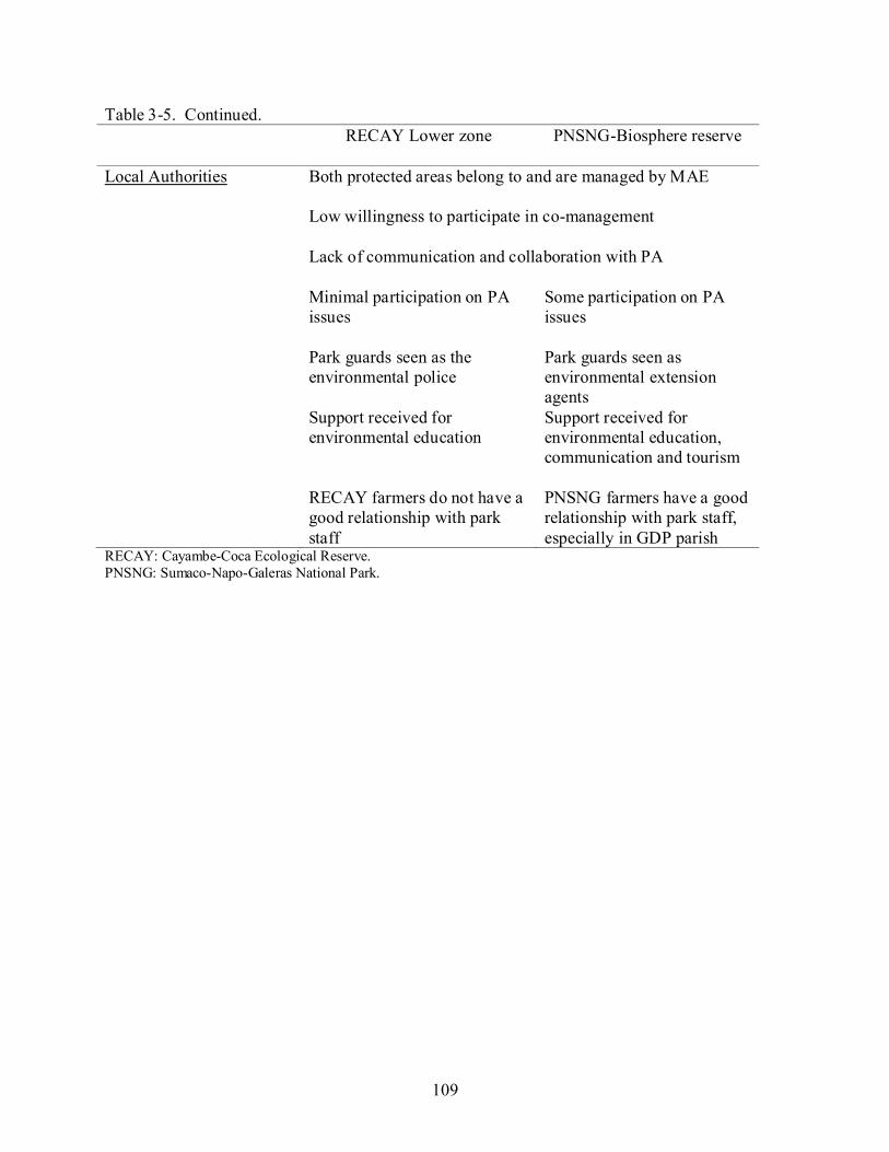
109
Table 3-5. Continued. RECAY Lower zone
PNSNG-Biosphere reserve
Local Authorities Both protected areas belong to and are managed by MAE Low willingness to participate in co-management Lack of communication and collaboration with PA
Minimal participation on PA issues
Some participation on PA issues
Park guards seen as the environmental police
Park guards seen as environmental extension agents
Support received for environmental education
Support received for environmental education, communication and tourism
RECAY farmers do not have a good relationship with park staff
PNSNG farmers have a good relationship with park staff, especially in GDP parish
RECAY: Cayambe-Coca Ecological Reserve. PNSNG: Sumaco-Napo-Galeras National Park.

110
Table 3-6. Sustainability-oriented activities influenced by Cayambe-Coca Ecological Reserve (RECAY) and Sumaco-Napo Galeras National Park (PNSNG) and carried out in El Chaco communities in 2005-2006.
RECAY
PNSNG Forest and water resource conservation
Protection and management of bamboo patches
X
Protection of riparian forests and on-farm forest patches
X
Establishment of nurseries with native forest resources and outplanting of stock onto farms
X
Environmental education workshops focused on benefits of forest resources for biodiversity and local livelihoods
X
X
Income-generating initiatives that promote local resources and production systems
Bamboo and lianas handicraft communal workshop
X Organic school farms & use of produce in schools
X X
Organic farms
X
Fish farming
X Women’s organic farming group and culinary recipes
X Oyster mushroom production
X
Orchid and bromeliad gardens
X X Design of ecological trails
X
Social innovations
Community telecommunications center managed by a local group of young people
X
Environmental activist youth group from Gonzalo Diaz de Pineda parish
X
First fair of native plants and seeds X X Environmental policy committee, promoted by Fundación EcoCiencia and Parks in Peril project
X X

111
Table 3-7. Descriptive statistics for farm context, land use outcomes and market and road infrastructure variables of Sumaco-Napo Galeras National Park (PNSNG) farms (N=241) and Cayambe-Coca Ecological Reserve (RECAY) farms (N=681) at El Chaco Municipality in the year 2005-2006. T-tests were run for comparing between PNSNG farms and RECAY farms. P-values for forest persistence were based on log transformed values where log Forest Persistence = log Forest – log (Pasture + Crops).
PNSNG RECAY p-value Variable Mean (SE) Mean (SE)
Farm Context Resides on farm Farm size (ha)
17 %
44 (3)
36 %
31.6 (1.3)
<0.0001 <0.0001
Land Use Outcomes per farm Crops (ha) Pasture (ha) Forest (ha) Forest persistence for all farms Forest persistence for non-border farms Forest persistence for border farms
0.24 (0.05)
18 (1.5) 26 (1.2)
1308.4 (363.6) 1070.4 (239.07)
1984.4 (698.5)
0.39 (0.04)
15 (1) 16 (1)
539.3 (116.4) 399.5 (140)
1000. (439.7)
0.09 0.10
<0.0001 0.0003
0.001 0.14
Market and Road Infrastructure Distance to closest town (km) Distance to El Chaco (km) Distance to secondary road (km) Distance to principal road (km) Farm on principal road Farm on secondary road Farm on walking path
3.8 (0.2) 11 (0.4) 2.8 (0.2) 7.4 (0.2)
0.4 % 36 % 63 %
4 (0.1)
13 (0.4) 0.8 (0.04)
3 (0.11) 23 % 29 % 48 %
0.57
0.006 <0.0001 <0.0001 <0.0001
0.029 <0.0001

112
Table 3-8. Bivariate correlation coefficients (Pearson correlation) between distances related variables. El Chaco Municipality, 2005-2006.
Variable Distance to protected area
Distance to El Chaco city
Distance to the closest town
Distance to secondary road
Distance to principal road
Distance to protected area
1
Distance to El Chaco city
-0.451** 1
Distance to closest town
-0.602** 0.507** 1
Distance to secondary road
-0.402** 0.246** 0.390** 1
Distance to principal road
-0.555** 0.123** 0.458** 0.686** 1
Table 3-9. Principal components analysis (PCA) loading table to generate a composite factor for distance variables at El Chaco municipality.
Variable Principal component 1 Distance to protected area -0.802 Distance to closest town 0.759 Distance to secondary road 0.777 Distance to principal road 0.855

113
Table 3-10. Results of the generalized linear model which identified the most important measured variables that explained forest persistence on farms adjacent to Cayambe-Coca Ecological Reserve (RECAY) and Sumaco-Napo Galeras National Park (PNSNG) in the Municipality of El Chaco in the year 2005-2006.
Source
Type III Sum of Squares
df*
Mean Square
F
p-value
Corrected Model 1248.96 7 178.42 55.93 <0.0001 Intercept 75.55 1 75.55 23.68 <0.0001 Protected Area 25.99 1 25.99 8.14 0.004 Border Factor 68.12 1 68.12 21.35 <0.0001 Distance Factor 217.36 1 217.36 68.14 <0.0001 Farm Size 26.14 1 26.14 8.19 0.004 Border Factor *Farm Size 90.42 1 90.42 28.34 <0.0001 Protected Area * Border Factor 71.11 1 71.11 22.29 <0.0001 Protected Area * Distance Factor 155.94 1 155.94 48.88 <0.0001 Error 2915.57 914 3.190 Total 4727.81 922 Corrected Total 4164.54 921
*df= degrees of freedom. Table 3-11. Parameter estimates for forest persistence on farms adjacent to Cayambe-Coca
Ecological Reserve (RECAY) and Sumaco-Napo Galeras National Park (PNSNG) in the Municipality of El Chaco in the year 2005-2006.
Variable ß
SE (Standard error)
Intercept 0.767 0.339 RECAY -1.485 0.351 PNSNG 0 Non-border farms -2.185 0.373 Border farms 0 Distance Factor 0.126 0.128 Farm Size 0.005 0.003 Non-border farms*Farm Size 0.020 0.004 Border farms*Farm Size 0 RECAY * Non-border farms 1.887 0.400 RECAY * Border farms 0 PNSNG * Non-border farms 0 PNSNG * Border farms 0 RECAY * Distance Factor 1.199 0.171 PNSNG *Distance Factor 0
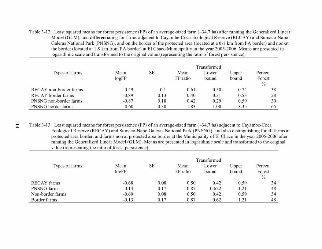
114
Table 3-12. Least squared means for forest persistence (FP) of an average-sized farm (~34.7 ha) after running the Generalized Linear Model (GLM), and differentiating for farms adjacent to Cayambe-Coca Ecological Reserve (RECAY) and Sumaco-Napo Galeras National Park (PNSNG), and on the border of the protected area (located at a 0-1 km from PA border) and non-at the border (located at 1-9 km from PA border) at El Chaco Municipality in the year 2005-2006. Means are presented in logarithmic scale and transformed to the original value (representing the ratio of forest persistence).
Transformed Types of farms
Mean logFP
SE
Mean FP ratio
Lower bound
Upper bound
Percent Forest
% RECAY non-border farms -0.49 0.1 0.61 0.50 0.74 38 RECAY border farms -0.89 0.13 0.40 0.31 0.53 28 PNSNG non-border farms -0.87 0.18 0.42 0.29 0.59 30 PNSNG border farms 0.60 0.30 1.83 1.00 3.35 65
Table 3-13. Least squared means for forest persistence (FP) of an average-sized farm (~34.7 ha) adjacent to Cayambe-Coca
Ecological Reserve (RECAY) and Sumaco-Napo Galeras National Park (PNSNG), and also distinguishing for all farms at protected area border, and farms non at protected area border at the Municipality of El Chaco in the year 2005-2006 after running the Generalized Linear Model (GLM). Means are presented in logarithmic scale and transformed to the original value (representing the ratio of forest persistence).
Transformed Types of farms
Mean logFP
SE
Mean FP ratio
Lower bound
Upper bound
Percent Forest
% RECAY farms -0.68 0.08 0.50 0.42 0.59 34 PNSNG farms -0.14 0.17 0.87 0.622 1.21 48 Non-border farms -0.69 0.08 0.50 0.42 0.59 34 Border farms -0.13 0.17 0.87 0.62 1.21 48

115
CHAPTER 4 CONCLUSIONS
Main Research Findings
The purpose of this dissertation was to understand the conservation implications of having
a variety of livelihood systems in the intervening spaces of protected areas (PAs) in the
northeastern Ecuadorian Amazon. I selected the El Chaco municipality as a focal study region
because two established protected areas have largely closed this forest frontier, and colonists
have had some time to adapt to their new environment. The analytical framework adopted and
adapted from Wood (2002) in this study helped organize existing information into a coherent
understanding of how key socioeconomic and biophysical drivers acting at different hierarchical
levels (proximate, intermediate and distant) interacted with one another to shape emergent
patterns of livelihood systems and related forest persistence within a forest frontier landscape.
Moreover, to link these overall patterns of frontier development with more nuanced local
outcomes, this study explored sustainable innovators and innovations that may counter fairly
predictable deforestation patterns. Furthermore, I took advantage of a unique situation in El
Chaco Municipality of having two adjacent rural communities that share the same biophysical
contexts, similar colonization histories, identical public policies, and comparable livelihood
opportunities, but with each linked to a different protected area. This natural research design
allowed me to develop a comparative analysis of the contrasting protected area-community
relations between Cayambe Coca Ecological Reserve (RECAY) and its neighboring community
and Sumaco Napo Galeras National Park (PNSNG) and its neighboring community. I was then
able to explore if these differences in PA-community relations were related to conservation
performance in the communities.

116
Global, regional and local events interacted with one another to shape El Chaco forest
frontier. Both key socioeconomic drivers (1970s oil boom, road construction, colonization and
land reform policies, financial credit for cattle, private investments in dairy processing plants,
dollarization) and biophysical ones ( topography, wet climate and low fertility soils) have, over
time, shaped the relatively homogenous livelihood patterns (small farms with a dependence on
market-oriented dairy farming and subsistence production fueled by family labor) and
differential proportions and types of forest cover on farms. Three proximate drivers – local
topography (semi-flat, moderate to steep slopes), road access and road density, and establishment
of protected areas – influenced the spatial patterns of land occupation, and subsequently the
spatial patterns of cattle husbandry- the main economic activity. At El Chaco 72% of the farms
had road access, while only 28% were remote. Remote farms were located in steep to moderate
slopes, close to protected areas, and focused on fattening cattle (especially bulls, steers and older
calves), and in some instances, production of naranjilla. Road-access farms were located on
semi-flat to flat terrain, and these farms focused mainly on market-based dairy production. These
cattle husbandry patterns also coincided with degrees of forest persistence, which was highly and
positively correlated with road access. Remote farms retained 64% of forest cover in the form of
scattered trees on pasture, some significantly large forest and bamboo patches, and riparian
forests. In contrast, farms with road access retained only 47% of their land under forest in the
form of scattered trees on pastures, small forest and bamboo patches, thin riparian forests, and
live-fences of introduced lechero (Croton cotinifolia L.) and guayaba (Psidium guajava L.). In
particular, the RECAY influence zone farms had less forest persistence, greater access to
principal and secondary roads and more people “living” on farm, compared to PNSNG farms of
which more were located on walking paths. Further, colonization processes began earlier in the

117
RECAY versus PNSNG influence zone, and these older farm settlements coincided with smaller
farms with less forest persistence.
Continued forest conversion in El Chaco is expected with ongoing road openings and
improvements that will greatly increase access to remote farms located at protected area borders,
with the consequences of isolating both PAs from its surrounding landscape and jeopardizing its
integrity. Despite road construction and clearing for cattle, I observed sustainable innovators and
innovations with potential for bucking deforestation trends, developing ways to learn jointly and
improve natural resource management strategies that support sustainable development at forest
frontier regions, and in the intervening spaces of protected areas. In particular, live fences and
retention of scattered trees on pastures were important innovations found mainly on access farms
in El Chaco municipality. These innovations had the particularity of having persisted over time
despite the deforestation trend. Their persistence could be related to the benefits provided to
farmers as delimitating farm boundaries and keep grazing animals in or out of the field (live
fences ) and as a timber source, food source and shelter for cattle (live fences, scattered trees).
Another pattern identified was that mainly farmers who came from regions where drought and
deforestation were serious problems, like the provinces of Loja and El Oro, tended to maintain
bamboo patches and riparian forests, and developed silvopastural systems. Although these
innovations related to the sustainable management of forest resources were not quantitatively
measured (because data were not available), qualitative information related to their evolution,
persistence and location could contribute to explain the differential proportions of forest
persistence and types of forest cover observed, and if these innovations are maintained and
promoted, they could potentially contribute to maintain forest cover at El Chaco.

118
In addition, these novel proposals and sustainable initiatives could also contribute to
expand protected area boundaries by linking them to the broader socio-ecological landscape,
garner support for its activities amongst its neighbors, and achieve PA objectives. It was found
that these proposals and activities (called “sustainable innovations” in Chapter 2 and
“sustainability-oriented activities” in Chapter 3) came about from both external actors like non-
governmental organizations, protected area managers, industry incentives, and governmental
programs, and internal features like indigenous traditions and ancestors, social groups, and
colonist regions of origin. In particular, contrasting relations between RECAY and its
neighboring community, and PNSNG and its neighboring community, greatly influenced the
development of these sustainability-oriented activities (i.e., promotion of on-farm forest
conservation, income-generating activities that promoted wise resource use, and social
innovations that indirectly or directly supported the PAs) identified in the neighboring
communities such that PNSNG-influenced communities outperformed RECAY-influenced
communities. These activities often were established through partnerships, seeking to formalize
relations and share in management. Activities perceived to be directly useful to neighboring
stakeholders were met with the greatest participation success (e.g., school-based organic farms,
bamboo protection and handicraft workshops) and contributed to further strengthening PA-
community relations. Respect for protected area borders may have also been directly influenced
by PA-community relations, while forest persistence on local farms appeared to be driven more
by road access, farm size, and possibly time since colonization than PA-community relations.
Although, the highest levels of forest persistence on PNSNG versus RECAY border farms
appeared to be related to clearer boundary demarcation and better community relations under
119
PNSNG staff leadership, border farmers expressed a clear intent to convert their forests to more
economically profitable uses when the opportunity arose.
Protected area-community relations were shaped primarily from PA establishment and
management history as well as ongoing community interactions with local protected area staff.
These two factors were interlinked with two others - community awareness of PA, and the
perceived benefits and costs of the PA to local people. Analyses of the key factors that shaped
these community-protected area relations, contribute to a growing body of conservation literature
on community-PA linkages and provide some guidance for protected area managers seeking to
engage their neighbors who can be a positive or negative force for protected area integrity.
This study found that protected area-community relations mattered, and did affect
conservation performance in neighboring communities. The establishment of protected area-
community relations is a complex and dynamic process shaped by a multitude of interacting
factors. This process could begin with positive interactions or negative conflicts. How
stakeholder concerns are addressed seemed key to building effective PA-community relations
that could potentially expand and protect the PA border and achieve greater PA integrity.
In conclusion, forest frontiers in Amazonia continue to be focal regions for biodiversity
conservation and colonist settlement. Protected areas could effectively close the frontier by
stopping colonization expansion up to their borders, and discouraging squatters and land
speculators from these ecologically fragile and biodiverse areas. The degree to which dynamic
frontier landscapes can accommodate the often conflicting goals of biodiversity conservation and
development depends on the livelihood systems that develop at the frontier, on the sustainable
innovators and innovations that emerge and, on the positive and equitable relations between PA
staff and its neighboring communities. As stated by Barrett et al. (2005) synergies between

120
neighboring communities and protected areas in the tropics do not emerge naturally; thus, more
flexible and adaptable approaches are critically needed in developing partnerships. A requisite to
most relationships, both honesty and addressing real concerns, are key elements that need to be
promoted between PAs and communities. Otherwise, current relationships deteriorate and
collaboration is disrupted, with the prospect of future partnerships seriously jeopardized in the
process.
Analysis of Research Process
Research for this interdisciplinary ecology dissertation was developed within the
framework of the project “Training and capacity building in community-based conservation for
institutions working in protected areas of Ecuador and Colombia” managed by the Tropical
Conservation and Development Program from the University of Florida. This was a great
learning opportunity that allowed knowledge exchange visits and sharing of experiences from
Ecuador and Colombia. I developed my dissertation research in partnership with Fundación
EcoCiencia, one of the partners in the above mentioned project. EcoCiencia was developing the
project “Strengthening Local Governance in the Natural Resource Management Arena in
Amazonian Ecuador” and they facilitated my visit to El Chaco and Gonzalo Pizarro
municipalities to discuss the feasibility and applicability of my proposal, and identified potential
areas where I could develop my research. Finally, I settled down at El Chaco and began field
research in January 2005.
Developing effective problem-solving research in tropical conservation and development
requires that the student has an understanding of the complex links between social and ecological
systems and an assortment of aptitudes, skills and abilities. Therefore the PhD student needs to
extend beyond disciplinary boundaries, work in teams, create networks, establish partnerships at
121
different levels, communicate in non-academic formats, and reflect critically on his/her own
perspectives and actions.
The approach of this interdisciplinary research evolved not only to objectively analyze
forest frontier dynamics, but also to engage community participants in the research. Methods
used, activities programmed, and length of time that I (student-researcher) spent in the study area
facilitated relationship building and trust among members of the community and government
authorities. The openness of this research approach resulted in organic emergence of learning
platforms. In essence, this expanded my role of researcher from objective collector and analyzer
of data to a facilitator of learning, as described in Arnold and Fernandez-Gimenez (2008).
Consequently, in my research study, rather than assume the researcher had no effect on study
subjects, I acknowledge that the research process was used as an educational and capacity
building opportunity for the group studied. During the development of this research I found that
most of the learning was based on experience as reported by Borrini-Feyerabend et al. (2000).
Activities that promoted joint learning included: parish workshops, participatory mapping,
farmer–to-farmer exchange visits, inter-parish group knowledge exchange visits, reinvigoration
of the farmers’ market, and the first fair of native plants and seeds. In particular, the inter-parish
group knowledge exchange visits and farmer–to-farmer exchange visits were learning platforms
that fostered local collaboration by generating trust and understanding of the problems faced by
different interest groups. These exchange visits that helped cross-learning of realities,
commonalities and differences, were encouraged by my field assistant, and were social
innovations that emerged from the research process itself. The field assistant played a very
important role of not only introducing these social innovations with me, but also increased the
122
possibility that these innovations in El Chaco municipality would continue after the field
research was concluded.
Achievements
During the development of this research, in conjunction with farmers, we were able to
generate a process of valuing forest resources, especially those located at each farm. Despite the
fact that forest inventories were not systematically developed and the data were not useful for
comparative statistical analysis, these inventories contributed to changing the way farmers
viewed their forests, becoming more cognizant of their forest potentials. We were able to identify
seedlings of several promising forest species and learned how to transfer those seedlings to the
home nurseries to reforest other areas of the farm or to exchange with other farmers. This
process developed into the “first fair of native plants and seedlings” in which farmers were able
to exchange plants and exchange knowledge about their own resources.
During the process of visiting different farmers all over the municipality, many farmers
became interested in coming along on my visits and learning what other farmers were doing.
This developed into farmer knowledge exchange visits from one parish to another, generating a
sense of community and appreciation of local knowledge.
This research also contributed to generate discussion around protected area management
issues, opening doors for discussion with municipal authorities, environmental ministry
authorities and local communities. Park rangers from both protected areas participated actively
during this research which created a forum for discussion between farm owners and park
authorities about conflictive perceptions of protected areas and possible conflict resolutions.
Conflictive Factors
At the beginning of the field research period, there was mistrust about this study and the
type of information that was going to be collected. I had to develop several strategies to socialize

123
my research and involve the farmers, UMDS (Municipal Unit of Sustainable Development) and
protected area staff from the beginning. At the UMDS (Municipal Unit of Sustainable
Development), the roles and action plans were not clearly defined; therefore, it was difficult to
coordinate my field research activities with technicians and involve them in all research
activities. The municipality extension and support activities chronogram did not coincide with
those of the communities. As a result, it was difficult to develop activities in conjunction with the
communities. In addition, there were times when the objectives of this dissertation faded, and
UMDS interests began to dominate.
Success Factors
Despite mistrust at the beginning of the research, I was able to clarify project scope and
objectives, and develop positive relations with different stakeholders. The support from protected
area staff, especially from Sumaco Napo Galeras National Park, and community leaders was a
key factor in accessing the communities. In addition, the development of applied research
responding to community interests facilitated the willingness of the farmers to participate in this
research process. Living at El Chaco for almost a year and being able to participate in all the
local activities (i.e. carnival, festivals, religious ceremonies, etc.) and visiting most of the
municipality allowed me to understand the context and local reality better.
During the process of developing this research at El Chaco, I not only expanded my role of
researcher to a facilitator of learning, I also became a mother. The first time I went to El Chaco I
went as a PhD student opening the door for developing my research. For the first field season I
was pregnant, and my mother accompanied me, “took care” of me and even provided field
assistance. For the final and long field season, I brought my husband and newborn son along.
These circumstances contributed to closing the gap between researcher and research subjects

124
(farmers), and made me seem more human and less distant. In the meantime, tending my family
while doing research was very challenging and distracting.
Ways Forward in El Chaco
My hope is that El Chaco Municipality take advantage of the results of this applied
research, continue promoting applied research to understand local realities, and in conjunction
with farmers, develop relevant programs and projects that address the dual goals of conservation
and development. Municipality and PA staff might take advantage of different universities and
research institutions to develop studies in conjunction with students and farmers. Knowledge
exchange visits could be promoted continuously and accompanied with technical support. Basic
ecological research is needed to understand the dynamics of the most important economic forest
species, in particular logma, cedro and ishpingo. In addition, research that determines the
economic potential of selected NTFPs (i.e. orchids and bromeliads) and timber products coupled
with analyses of sustainable levels of exploitation by local communities on their own farms
would be useful. To encourage the valuation and exploitation of local forest resources,
continuous support is needed in the implementation of home-nurseries with native seedlings
extracted from the forest, knowledge exchange about forest resources and plants, and promotion
of a fair of native seedlings and seeds. By taking advantage of local initiatives and innovations,
agroforestry and silvopastural techniques could be promoted. UMDS technicians could develop
more activities with farmers’ communities, making extra effort to get to remote places to visit all
the farmers and understand better the reality of the farmers. They might also consider training
locals as para-technicians in agriculture and veterinary activities. El Chaco municipality should
take advantage of their potentiality in relation to the protected areas and coordinate with PA staff
in different activities and co-management.

125
The objectives of this interdisciplinary research and particular personal circumstances
required that I extend time spent in the field and embrace a more participatory approach in which
I took on an additional facilitator role. This helped me to better understand local realities,
constraints and contexts - an understanding that hopefully extended to my research findings that
identified: emergent patterns of livelihood systems, their drivers, and related forest persistence in
El Chaco and sustainable innovators and innovations, described and analyzed personal relations
between PA staff and local communities, and consequently understand the conservation
implications of livelihood and park interactions in the Ecuadorian Amazon.

126
APPENDIX A HOUSEHOLD QUESTIONNAIRE
Household Interview Questionnaire
Household interview: A detailed household questionnaire was administered and divided in three parts. The first addressed productivity and income (farm activities, dairy production, cattle production, on and off-farm income, remittances, market and credit access). The second part focused on farm context (topography, household location, land tenure status, land acquisition method, and year migration to region), and the third part dealt with productive resources (labor, production inputs, technical assistance, infrastructure and technology). CUESTIONARIO PARA LAS FAMILIAS VISITADAS Titular finca Parroquia Relación con área protegida Area de la finca Uso del suelo finca Area total Pastos Cultivos anuales Cultivos perennes, semiperennes Chaparros Rastrojos Bosques secundarios PRODUCTIVIDAD E INGRESOS Actividades económicas Inventario ganado bovino carne, producción anual, ingresos Inventario ganado bovino leche, producción diaria, ingresos Inventario: Caballos, Mulas, Burros (medios de transporte y para sacar productos) Inventario Cuyes, consumo y producción Inventario Pollo engorde, consumo y producción Inventario Gallinas ponedoras huevos, consumo y producción Inventario Cerdos, consumo y producción Inventario Peces, consumo y producción Inventario otros Cultivos: Inventario de Tomate de árbol, Naranjilla, producción, ingresos, área usada Otros cultivos Producción de Hongos Ostra Otras actividades: Artesanal, Turística, Forestal, Contexto institucional Utilizan crédito? Para qué actividades? Quién lo da? Reciben asistencia técnica ganadería? Reciben asistencia técnica agricultura? Reciben asistencia técnica forestal? Reciben asistencia técnica peces, cuyes, cerdos etc.?
127
Ingresos dentro y fuera de la finca Empleo fuera de la finca, quién, cuándo, dónde. Reciben dinero de alguien que esta fuera de la finca?- Remesas Reciben dinero de otras actividades fuera de la finca? Qué actividades? CONTEXTO DE LA FINCA Distancia a carretera pavimentada Distancia a vías secundarias Distancia El Chaco Distancia al poblado mas cercano Existencia de otras fincas: Dónde? Parroquia? Cuál es el uso? Cuál es la relación con esta? Quién las maneja? Topografía Historia de colonización Origen Tiempo de residencia en este lugar Otros sitios que han vivido antes Cómo era la finca cuando ustedes llegaron? Método de adquisición de la finca Año en el que llegó a la finca Status título de propiedad Vive en predio, poblado, ciudad Composición de la familia y características socioeconómicas PERSONA SEXO EDAD NIVEL
EDUCACION RECURSOS Mano de obra Cuál es la fuente principal de mano de obra en su finca? utiliza jornaleros u otra mano de obra contratada para trabajar en la finca? para qué trabajos? cuánto se les paga? Insumos, Maquinaria, Herramientas Descripción de la infraestructura de la finca (por ejemplo: piscinas peces, galpones pollos, galpones cuyes, cochera, invernadero, hongos) Preguntas adicionales: Uso agua de dónde sale agua para lavar?, bañarse? agua para cocinar, tomar? agua para animales? peces, vacas, etc. Combustible para cocinar Con qué cocina? si usa leña: quien la recoge? cuales son los mejores palos para leña? de dónde sale la leña? Usos maderables y no maderables Que materiales usa para hacer la casa? si usa madera: cuales son los mejores palos?

128
de dónde sale esa madera? que madera utiliza para cercas? Corrales? Galpones? de dónde sale esta madera? si ha vendido madera del bosque; que especies? las vendió en trozas, aserradas , tablas ya como muebles? a quien le vendió? A como vendió? Otros productos del bosque; miel de abejas, tintes, fibras, bejucos, animales, etc.
Guidelines for Participatory Mapping-Mapa Parlante
Indicaciones para el mapa de la finca CÓMO ES SU FINCA? Cómo era esta finca cuando usted llegó? •Localizar los límites físicos y naturales •Indicar la distancia al área protegida y a las áreas con mayor cobertura de bosque •Indicar la distancia al centro poblado •Localizar los recursos hídricos: lagos, lagunas, ríos, quebradas, pantanos •Estado de las fuentes hídricas(tiene protección, están contaminadas, son cuidadas, requieren reforestación, etc.) el por qué de este estado? Para qué protejo el bosque en las fuentes hídricas? •Localizar las vías de acceso: carretera principal, carretera de segundo orden, caminos de herradura, desbanques, chasquillanes, etc. •Localizar las zonas con mayor pendiente, pendiente moderada, zonas planas y áreas que se inundan •Indicar el tamaño de la finca •Indicar las actividades productivas de la finca (ganadería, lechería, agricultura, peces, etc.) e indicar más o menos cuánta área de la finca estas actividades están ocupando, e indicar cuál es la actividad productiva más importante •Indicar cercos vivos, árboles en los potreros, áreas con guadua, área en bosque •Indicar historias del bosque, más o menos que edad tiene, historia de uso, por qué está en pie, qué se piensa hacer con este bosque CÓMO QUEREMOS QUE SE VEA NUESTRA FINCA EN EL FUTURO?
129
APPENDIX B PROTECTED AREA QUESTIONNAIRES
Semi-structured interviews, centered on the following questionnaires in Spanish were
conducted to gather stakeholder perceptions of protected area-community relations and the
connection between those relations and conservation performance in neighboring communities.
Questionnaires were applied with 2 protected area directors, 5 park guards, 2 environmental
municipal authorities, 27 farmers, and one international cooperation representative.
Cuestionario Director de Area RECAY
HISTORIA DE VIDA: De dónde es usted? Cuántos años tiene? Educación: Dónde vive: Historia de trabajo con el MAE, INEFAN Desde hace cuanto tiempo es DIR.AREA? En qué otras AP trabajo? Que significa para usted ser DIR.AREA? Cuales son sus funciones como DIR.AREA? Por qué es usted DIR.AREA? Cómo describe usted el AP en la que usted trabaja. Qué es lo mas bonito, interesante del AP? HISTORIA DE CREACION DEL AREAPROTEGIDA: Enfocada a que estaba pasando en el Municipio en esa época, DIA DE TRABAJO Por favor describa como es un día de trabajo suyo. CAPACITACION, APOYO Capacitación ha recibido y de quien en DIR.AREA, en cursos, relación con comunidad, en bosques, en fauna, en inventarios, etc. Qué otras instituciones los apoyan? LISTADO DE INST. QUE APOYAN Y EN QUE? EQUIPO, DOTACION Qué tipo de equipo, dotación recibe usted para poder realizar su trabajo? RELACION CON AUTORIDADES DEL AP Y AFINES Su relación con:
• Dir.Area zona alta • Los guardaparques (GPQ) de esta AP ZONA BAJA • MAE- INEFAN El INDA • EL IERAC • EL PEP, BIORESERVA DEL CONDOR • FUNDACIONES ECOCIENCIA, ANTISANA, RUMICOCHA, OIKOS, ECOLEX Y
OTRAS • Municipio, UMDS? Evolución de estas relaciones • La comunidad aledaña

130
Cómo se trabaja en relación con las dos áreas protegidas en el municipio? Ustedes trabajan en conjunto? Hay planes de acción conjuntos? Cual es su relación con otro DIR AREA SUMACO Y SUS GPQS? Qué significa para el Chaco tener 2 AP? INFLUENCIAS DEL AP EN COMUNIDAD Beneficios, ventajas y desventajas del AP para la comunidad Los influencia ellos de alguna forma ya sea positiva o negativa el AP? Lo que hay dentro del AP los ayuda, incomoda, es perjudicial? Qué hay dentro del AP? INFLUENCIAS DE LA COMUNIDAD EN AP PRINCIPALES CONFLICTOS DEL AP Amenazas al AP De quien son esas amenazas? Cuales son los problemas que tiene el AP? Cómo controlar, cual seria un buen plan? Cómo puede la comunidad aledaña participar en el manejo del AP? Cómo puede el municipio participar en el manejo del AP? Cómo puede la UMDS participar en el manejo del AP? Cómo puede la sociedad civil participar en el manejo del AP RELACIONES CON AP Ustedes conoce toda el AP? Qué hay allí? Conocen los límites-bordes del AP? De quien es el AP? Y Cómo se maneja? Con fondos de quien? Quién hizo el plan de manejo? Tiene y conoce el plan de manejo? Cómo lo usan? Actividades que se realizan con la comunidad aledaña ahora, antes a futuro Actividades en conjunto con UMDS, Municipio, escuelas, colegios Actividades con ONGs, fundaciones, etc. AREA PROTEGIDA Y SU FUTURO Cómo ven ustedes el AP? Cómo un banco? Cómo algo que guardamos para el futuro? Cómo se debería manejar un AP? Quién lo debería hacer? Sugerencias de cómo manejar, ayudar, colaborar con AP, y viceversa. Cómo AP les podría ayudar a ustedes? Cómo es un AP ideal?
Cuestionario Director de Area PNSNG
HISTORIA DE VIDA: De dónde es usted? Cuantos años tiene? Educación: Dónde vive: Historia de trabajo con el MAE, INEFAN Desde hace cuanto tiempo es DIR.AREA? En qué otras AP trabajo? Qué significa para usted ser DIR.AREA? Cuales son sus funciones como DIR.AREA? Por qué es usted DIR.AREA? Cómo describe usted el AP en la que usted trabaja. Qué es lo mas bonito, interesante del AP? HISTORIA DE CREACION DEL AREAPROTEGIDA:

131
Enfocada a que estaba pasando en el Municipio en esa época, DIA DE TRABAJO Por favor describa como es un día de trabajo suyo CAPACITACION, APOYO Capacitación ha recibido y de quien en DIR.AREA, en cursos, relación con comunidad, en bosques, en fauna, en inventarios, etc. Qué otras instituciones los apoyan? LISTADO DE INST. QUE APOYAN Y EN QUE? EQUIPO, DOTACION Qué tipo de equipo, dotación recibe usted para poder realizar su trabajo? RELACION CON AUTORIDADES DEL AP Y AFINES Su relación con:
• Los GPQ de esta ZONA DEL Chaco • Los otros GPQ del AP • MAE- INEFAN El INDA • EL IERAC • EL PEP, BIORESERVA DEL CONDOR • FUNDACIONES de apoyo ECOCIENCIA, ANTISANA, RUMICOCHA, OIKOS,
ECOLEX Y OTRAS • LA CORBS, GTZ • Municipio, UMDS? Evolución de estas relaciones • La comunidad aledaña
Cómo se trabaja en relación con las dos áreas protegidas en el municipio? Ustedes trabajan en conjunto? Hay planes de acción conjuntos? Cual es su relación con otro DIR AREA RECAY Y SUS GPQS? Qué significa para el Chaco tener 2 AP? INFLUENCIAS DEL AP EN COMUNIDAD Beneficios, ventajas y desventajas del AP para la comunidad Los influencia ellos de alguna forma ya sea positiva o negativa el AP? Lo que hay dentro del AP los ayuda, incomoda, es perjudicial? Qué hay dentro del AP? INFLUENCIAS DE LA COMUNIDAD EN AP PRINCIPALES CONFLICTOS DEL AP Amenazas al AP De quien son esas amenazas? Cuales son los problemas que tiene el AP? Cómo controlar, cual seria un buen plan? Cómo puede la comunidad aledaña participar en el manejo del AP? Cómo puede el municipio participar en el manejo del AP? Cómo puede la UMDS participar en el manejo del AP? Cómo puede la sociedad civil participar en el manejo del AP RELACIONES CON AP Ustedes conoce toda el AP? Qué hay allí? Conocen los límites-bordes del AP? De quien es el AP? Y Cómo se maneja? Con fondos de quien? Quién hizo el plan de manejo? Tiene y conoce el plan de manejo? Cómo lo usan?

132
Actividades que se realizan con la comunidad aledaña ahora, antes a futuro Actividades en conjunto con UMDS, Municipio, escuelas, colegios Actividades con ONGS, fundaciones, etc. AREA PROTEGIDA Y SU FUTURO Cómo ven ustedes el AP? Cómo un banco? Cómo algo que guardamos para el futuro? Cómo se debería manejar un AP? Quién lo debería hacer? Sugerencias de cómo manejar, ayudar, colaborar con AP, y viceversa. Cómo AP les podría ayudar a ustedes? Cómo es un AP ideal?
Cuestionario Guarda Parques
HISTORIA DE VIDA: De dónde es usted? Cuantos años tiene? Educación: Dónde vive: Historia de trabajo con el MAE, INEFAN Desde hace cuanto tiempo es GPQ? En que otras AP trabajo? Qué significa para usted ser GPQ? Cuales son sus funciones como GPQ? Por qué es usted GPQ? Cómo describe usted el AP en la que usted trabaja. Qué es lo mas bonito, interesante del AP? DIA DE TRABAJO Por favor describa Cómo es un día de trabajo suyo CAPACITACION, APOYO Capacitación ha recibido y de quien en GPQ, en cursos, relación con comunidad, en bosques, en fauna, en inventarios, etc. Qué otras instituciones los apoyan? EQUIPO, DOTACION Qué tipo de equipo, dotación recibe usted para poder realizar su trabajo? RELACION CON AUTORIDADES DEL AP Su relación con:
• Director de área • Otros GPQ de esta AP y de la otra en la región • MAE- INEFAN El INDA • EL IERAC • Municipio, UMDS? • La comunidad aledaña
Cómo se trabaja en relación con las dos áreas protegidas en el municipio? Ustedes trabajan en conjunto? Hay planes de acción conjuntos? Cual es su relación con otros GPQS? Qué significa para el Chaco tener 2 AP? INFLUENCIAS DEL AP EN COMUNIDAD Beneficios, ventajas y desventajas del AP para la comunidad Los influencia ellos de alguna forma ya sea positiva o negativa el AP? Lo que hay dentro del AP los ayuda, incomoda, es perjudicial? Qué hay dentro del AP?

133
INFLUENCIAS DE LA COMUNIDAD EN AP PRINCIPALES CONFLICTOS DEL AP Amenazas al AP De quien son esas amenazas? Cuales son los problemas que tiene el AP? Cómo controlar, cual seria un buen plan? Cómo puede la comunidad aledaña participar en el manejo del AP? Cómo puede el municipio participar en el manejo del AP? Cómo puede la UMDS participar en el manejo del AP? Cómo puede la sociedad civil participar en el manejo del AP RELACIONES CON AP Ustedes conoce toda el AP? Qué hay allí? Conocen los límites-bordes del AP? De quien es el AP? Y Cómo se maneja? Con fondos de quien? Quién hizo el plan de manejo? Tiene y conoce el plan de manejo? Cómo lo usan? Actividades que se realizan con la comunidad aledaña ahora, antes a futuro Actividades en conjunto con UMDS, Municipio, escuelas, colegios Actividades con ONGS, fundaciones, etc. AREA PROTEGIDA Y SU FUTURO Cómo ven ustedes el AP? Cómo un banco? Cómo algo que guardamos para el futuro? Cómo se debería manejar un AP? Quién lo debería hacer? Sugerencias de cómo manejar, ayudar, colaborar con AP, y viceversa. Cómo AP les podría ayudar a ustedes? Cómo es un AP ideal?
Cuestionario Finquero
Sabe usted de la existencia de un AP cerca de su comunidad?
HISTORIA DEL AP Qué saben ustedes del AP? Dónde está ubicada el AP con relación a su comunidad, a su finca? Cuándo se creo? Cómo? Por qué? Desde hace cuanto tiempo se creo el área protegida? Podría contar como fue el proceso de creación y establecimiento del AP? Ustedes fueron invitados a la creación del AP? Cómo? Participaron? RELACION CON AUTORIDADES DEL AP Relación de su comunidad con:
• el Area protegida • Sabe quienes son los Guardaparques y qué hacen? Tienen alguna relación con ellos? • MAE- INEFAN El INDA • EL IERAC • Municipio, UMDS?
INFLUENCIAS DEL AP EN USTEDES Beneficios, ventajas y desventajas del AP Los influencia a ustedes de alguna forma ya sea positiva o negativa el AP? Lo que hay dentro del AP los ayuda, incomoda, es perjudicial?

134
Qué hay dentro del AP? RELACIONES CON AP Ustedes conocen el AP? Han ido a visitarla? Qué hay allí? Conocen los límites-bordes del AP? Saben si AP tiene un plan de manejo? Quién lo hizo? Ustedes Lo conocen? Para qué sirve? Ustedes participan del manejo del AP? Saben si pueden participar en el manejo del AP? Cómo ven ustedes el AP? Cómo un banco? Cómo algo que guardamos para el futuro? De quién es el AP? Para qué hay un AP? Cómo se debería manejar un AP? Quién lo debería hacer? Sugerencias de cómo manejar, ayudar, colaborar con AP, y viceversa. Cómo AP les podría ayudar a ustedes?
Cuestionario Alcalde, Concejales, Técnicos UMDS
HISTORIA DE TRABAJO: Historia de trabajo con el Municipio del Chaco
• Si tuviera que contarle al mundo como es el Cantón EL Chaco, cómo lo describiría? RELACIONES CON AP
• Usted conoce, ha visitado alguna de las áreas protegidas? • Conocen los límites-bordes del AP? • De quien es el AP? Y Cómo se maneja? Con fondos de quien? • Qué significa para el Chaco tener 2 AP que cubren el 80% de su territorio? • De quién son estas AP y cual es la finalidad de estas AP? • Cuales serían los beneficios y/o desventajas de tener 2 áreas protegidas en el Chaco?
HISTORIA DE CREACION DE LAS AREAS PROTEGIDAS: Sabe algo de la historia de las AP? Podría contar que estaba pasando en el Municipio en esa época? RELACION CON AUTORIDADES DEL AP Y AFINES
• Cómo se trabaja en relación con las dos áreas protegidas en el municipio? Ustedes trabajan en conjunto con el MAE, los jefes del área, GPQs?
Su relación con: • La comunidad aledaña, las Juntas parroquiales etc. • EL INDA • EL PROYECTO GRAN SUMACO • LA CORBS, GTZ • EL PEP, BIORESERVA DEL CONDOR • FUNDACIONES de apoyo ECOCIENCIA, ANTISANA, RUMICOCHA, OIKOS,
ECOLEX Y OTRAS INFLUENCIAS DEL AP EN comunidad Beneficios, ventajas y desventajas del AP para la comunidad INFLUENCIAS DE LA COMUNIDAD EN AP PRINCIPALES CONFLICTOS DEL AP Amenazas al AP De quien son esas amenazas? Cuales cree usted que son los problemas que tiene el AP?

135
Cómo controlar, cual sería un buen plan? PLAN MANEJO Conoce de la existencia de los planes de manejo de las AP? Quién hizo el plan de manejo? Sabe como lo usan? Actividades que se realizan con la comunidad aledaña ahora, antes a futuro Actividades en conjunto con UMDS, Municipio, escuelas, colegios Actividades con ONGS, fundaciones, etc. Cómo puede la comunidad aledaña participar en el manejo del AP? Cómo puede el municipio participar en el manejo del AP? Cómo puede la UMDS participar en el manejo del AP? Cómo puede la sociedad civil participar en el manejo del AP? AREA PROTEGIDA Y SU FUTURO Cómo ven ustedes el AP? Cómo se debería manejar un AP? Quién lo debería hacer? Sugerencias de cómo manejar, ayudar, colaborar con AP, y viceversa. Cómo AP les podría ayudar a ustedes? Cómo es un AP ideal
Cuestionario Director Proyecto Gran Sumaco
Historia de vida: De dónde es usted? Cuantos años tiene? Educación: Dónde vive: Historia de trabajo con el MAE, INEFAN En qué otras AP trabajo anteriormente? Desde hace cuanto tiempo es DIR Proyecto Sumaco? Qué significa para usted ser DIR.Proyecto GS? Cuales son sus funciones como DIR.PGS? Cómo describe usted el TRABAJO QUE USTED REALIZA Y EN RELACION AL AREA PROTEGIDA? Qué es lo mas bonito, interesante del PNS? HISTORIA DE CREACION DEL PGS, DE LA RESERVA DE LA BIOSFERA Y DEL PNSNG: Cómo fue el proceso de creación del PNS y de la reserva de la Biosfera Sumaco? RELACION CON AUTORIDADES DEL AP Y AFINES Su relación con:
• Los GPQ de esta ZONA DEL Chaco • Los otros GPQ del AP • MAE- INEFAN El INDA • EL IERAC • EL PEP, BIORESERVA DEL CONDOR • FUNDACIONES de apoyo ECOCIENCIA, ANTISANA, RUMICOCHA, OIKOS,
ECOLEX Y OTRAS • LA CORBS, GTZ • Municipio, UMDS? Evolución de estas relaciones

136
• La comunidad aledaña Cómo se trabaja en relación con las dos áreas protegidas en el municipio? Ustedes trabajan en conjunto? Hay planes de acción conjuntos? Cual es su relación con otro DIR AREA RECAY Y SUS GPQS? Qué significa para el Chaco tener 2 AP? CAPACITACION, APOYO Capacitación ha recibido y de quien en DIR.AREA, en DIR PGS en cursos, relación con comunidad, en bosques, en fauna, en inventarios, etc. Qué otras instituciones los apoyan? LISTADO DE INST. QUE APOYAN Y EN QUE? EQUIPO, DOTACION Qué tipo de equipo, dotación recibe usted para poder realizar su trabajo? INFLUENCIAS DEL AP EN comunidad Beneficios, ventajas y desventajas del AP para la comunidad Los influencia ellos de alguna forma ya sea positiva o negativa el AP? Lo que hay dentro del AP los ayuda, incomoda, es perjudicial? Qué hay dentro del AP? INFLUENCIAS DE LA COMUNIDAD EN AP PRINCIPALES CONFLICTOS DEL AP Amenazas al AP De quien son esas amenazas? Cuales son los problemas que tiene el AP? Cómo controlar, cual seria un buen plan? RELACIONES CON AP Ustedes conoce toda el AP? Qué hay allí? Conocen los límites-bordes del AP? De quien es el AP? Y Cómo se maneja? Con fondos de quien? Quién hizo el plan de manejo? Tiene y conoce el plan de manejo? Cómo lo usan? Actividades que se realizan con la comunidad aledaña ahora, antes a futuro Actividades en conjunto con UMDS, Municipio, escuelas, colegios Actividades con ONGS, fundaciones, etc. Cómo puede la comunidad aledaña participar en el manejo del AP? Cómo puede el municipio participar en el manejo del AP? Cómo puede la UMDS participar en el manejo del AP? Cómo puede la sociedad civil participar en el manejo del AP? AREA PROTEGIDA Y SU FUTURO Cómo ven ustedes el AP? Cómo un banco? Cómo algo que guardamos para el futuro? Cómo se debería manejar un AP? Quién lo debería hacer? Sugerencias de cómo manejar, ayudar, colaborar con AP, y viceversa. Cómo AP les podría ayudar a ustedes? Cómo es un AP ideal o una Reserva de la Biosfera ideal?

137
APPENDIX C PHOTOS DEPICTING METHOLOGIES AND ACTIVITIES DEVELOPED DURING
RESEARCH
A
B
Figure C-1. A one-week rapid reconnaissance of all five study parishes in the municipality of El Chaco. A) Panoramic Gonzalo Díaz de Pineda parish . B) Visiting Linares parish.

138
A
B
Figure C-2. Participatory workshops at different parishes. A) Elaborating the maps of each parish sector . B) Presenting the map to other parish members.

139
A B
C
Figure C-3. Farms visits. A) Transect walk . B) Mapa Parlante (Talking Mapping) and Interview. C) Forest Inventories

140
Figure C-4. Transplanting seedlings from forest to tree nurseries.
A B
Figure C-5. First fair of native plants. A) Plants display. B). “El Bombón” Nursery display from the Gonzalo Díaz de Pineda parish..

141
A
B
Figure C-6. Knowledge exchange visits. A) Discussing about how to establish Farmer-home nurseries. B) Discussing about Trout fish farming.
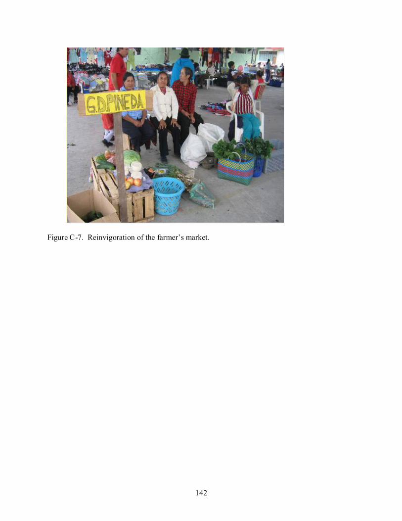
142
Figure C-7. Reinvigoration of the farmer’s market.
143
LIST OF REFERENCES
Abbot, J.I.O., Thomas, D.H.L, Gardner, A.A., Neba, S.E., Khen, M.W., 2001.Understanding the links between conservation and development in the Bamenda highlands, Cameroon. World Development 29, 1115-1136.
Altieri, M., 1999. Applying agroecology to enhance the productivity of peasant farming systems in Latin America. Environment, Development and Sustainability 1, 197-217.
Anthony, B.P., 2007. The dual nature of parks: attitudes of neighboring communities towards Kruger National Park, South Africa. Environmental Conservation 34 (3), 236-245.
Arnold, J.S., Fernandez-Gimenez, M.E., 2008. Engaging communities through participatory research. In: Donoghue, E.M., Sturtevant, V.S. (Eds.), Forest Community Connections: Implications for Research, Management and Governance. Resources for the Future, Washington DC, pp. 66-87.
Ashby, J., Braun, A.R., García, T., Guerrero, M.P., Hernandez, L.A., Quirós, C.A., Roa, J.I., 2000. Investing in farmers as researchers. Experience with agricultural research committees in Latin America. Publication No.318. International Center for Tropical Agriculture, (CIAT), Cali.
Bajracharya, S.B., Furley, P.A., Newton, A.C., 2005. Effectiveness of community involvement in delivering conservation benefits to the Annapurna Conservation Area, Nepal. Environmental Conservation 32 (3), 239-247.
Bajracharya, S.B., Furley, P.A., Newton, A.C., 2006. Impacts of community based conservation on local communities in the Annapurna Conservation Area, Nepal. Biodiversity Conservation 15, 2765-2786.
Baral, N., Stern, M.J., Heinen, J.T., 2007. Integrated conservation and development project life cycles in the Annapurna Conservation Area, Nepal: is development overpowering conservation? Biodiversity Conservation 16, 2903-2917.
Barborak, J., 1998. Buffer zone management: lessons for the Maya Forest. In: Primack, R.B., Bray D., Galletti, H.A., Ponciano, I., (Eds.), Timber, Tourists, and Temples: Conservation and Development in the Maya Forest of Belize, Guatemala, and Mexico. Island Press, Washington DC, pp. 209-221.
Barrett, C.B., Lee, D.R., McPeak, J.G., 2005. Institutional arrangements for rural poverty reduction and resource conservation. World Development 33(2), 193–197.
Bawa, K.S., 2006. Globally dispersed local challenges in conservation biology. Conservation Biology 3, 696-699.
Bawa, K.S., Gladwin, J., Siddappa, S., 2007. Poverty, biodiversity and institutions in forest-agriculture ecotones in the Western Ghats and Eastern Himalaya ranges of India. Agriculture, Ecosystems and Environment 121, 287-295.

144
Bennett, A.F., Radford, J.Q., Haslem, A., 2006. Properties of land mosaics: implications for nature conservation in agricultural environments. Biological Conservation 133, 250-264.
Benítez, S., 2003. The Condor Bioreserve in Ecuador: use of the functional landscape approach to conservation of montane ecosystems. Mountain Research and Development 23, 212-214.
Berkes, F., Colding, J., Folke, C., 2000. Rediscovery of traditional ecological knowledge as adaptive management. Ecological Applications 10, 1251–1262.
Bernard, H.R., 2002. Research Methods in Anthropology: Qualitative and Quantitative Approaches. Altamira Press, Walnut Creek.
Bernet, T., Hervé, D., Lehman, B., Walker, T., 2002. Improving land use by slope farmers in the Andes: an economic assessment of small-scale sprinkler irrigation for milk production. Mountain Research and Development 22 (4), 375–382.
Borrini-Feyerabend, G., Farvar, M. T., Nguinguiri, J. C., Ndangang, V. A., 2000. Comanagement of Natural Resources: Organising, Negotiating and Learning-by-Doing. GTZ and IUCN, Kasparek Verlag, Heidelberg
Brandon, K., Redford, K.H., Sanderson, S.E., 1998. Parks in Peril: People, Politics, and Protected Areas. The Nature Conservancy and Island Press, Washington DC.
Brondizio, E.S., McCraken, S.D., Moran, E., Siqueira, A.D., Nelson, D.R., Rodriguez-Pedraza, C., 2002. The colonist footprint: toward a conceptual framework of land use and deforestation trajectories among small farmers in the Amazonian frontier. In: Wood, C.H., Porro, R. (Eds.), Deforestation and Land Use in the Amazon. University of Florida Press, Gainesville, pp. 133-161.
Browder, J., 1996. Reading colonists landscapes: social interpretations of tropical forest patches in an Amazonian agricultural frontier. In: Schelhas, J., Greenberg, R. (Eds.), Forest Patches in Tropical Landscapes. Island Press, Washington DC, pp. 285-299.
Browder, J.O., Godfrey, B.J., 1997. Rainforest Cities, Urbanization, Development and Globalization of the Brazilian Amazon. Columbia University Press., New York.
Browder, J.O., Pedlowski, M., Summers, P.M., 2004. Land use patterns in the Brazilian Amazon: comparative farm-level evidence from Rondônia. Human Ecology 32, 197-224.
Bruner, A.G., Gullison, R.E., Rice, R.E., da Fonseca, G.A., 2001. Effectiveness of parks in protecting tropical biodiversity. Science 291, 125-128.
Buck, L.E., Wollenberg, E., Edmunds, D., 2001. Social learning in the collaborative management of community forests: lessons from the field. In: Wollenberg, E., Edmunds, D., Buck, L.E., Fox., Brodt, S. (Eds.), Social Learning in Community Forests. Center for International Forestry Research, Bogor, pp. 1-20.

145
Budowski, G., 1987. Living fences in tropical America, a widespread agroforestry practice. In: Gholz, H.L. (Ed.), Agroforestry: Realities, Possibilities and Potentials. Springer-Verlag, New York, pp. 169-178.
Chomitz, M.K., Gray, D.A., 1996. Roads, lands, markets and deforestation, a spatial model of land use in Belize. World Bank Economic Review 10 (3), 487-512.
CRID (Regional Disaster Information Center Latin America), 2002. Ecuador’s forgotten volcano: the eruption of Reventador. Available from: <http://www.crid.or.cr/crid/CD_EIRD_Informa/ing/No6_2002/art8.htm> (accessed January, 2008).
DeFries, R., Hansen, A., Newton, A.C., Hansen, M.C., 2005. Increasing isolation of protected areas in tropical forests over the past twenty years. Ecological Applications 15, 19-26.
Dennis, Jr.F.G., Herner, R.C., Camacho, S., 1985. Naranjilla: a potential cash crop for the small farmer in Latin America. Acta Horticulturae 158, 475-481.
Dudley, N., Belokurov, A., Borodin, O., Higgins-Zogib, L., Hockings, M., Lacerda, L., Stolton, S., 2004. Are protected areas working? An analysis of forest protected areas. World Wildlife Fund International, Gland.
EcoCiencia (Fundación EcoCiencia), 2004. Proyecto Fortalecimiento a Gobiernos Locales. Available from: <http://www.ecociencia.org.> (accessed January 2008).
EcoCiencia, (Fundación EcoCiencia), 2006. El Chaco en Cifras. Fundación Ecociencia, Quito.
ECOLEX (Corporación de Gestión y Derecho Ambiental), FUNAN (Fundación Antisana), 2006. Identificación, Caracterización, Manejo y Resolución de Conflictos de Tenencia de la Tierra entre el Río Chalpi Grande y Río Malo de la Reserva Ecológica Cayambe-Coca. ECOLEX, FUNAN, Quito.
Emerton, L., 2001. The nature of benefits and the benefits of nature. In: Hulme, D., Murphree, M., (Eds.), African Wildlife and Livelihoods. James Currey Ltd, Oxford, pp. 208-226.
Engel, P.G.H., 1997. The Social Organization of Innovation: A Focus on Stakeholder Interaction. Royal Tropical Institute, Amsterdam.
Ellis, E.A., 1996. Land and tree-use on colonist farms in the Aguarico sector, Cayambe-Coca Ecological Reserve, Ecuador. (M.A. Thesis). University of Florida, Gainesville.
Estrada, A., Cammarano, P., Coates-Estrada, R., 2000. Bird species richness in vegetation fences and in strips of residual rain forest vegetation at Los Tuxtlas, Mexico. Biodiversity Conservation 9, 1399-1416.
Faminow, M.D., 1998. Cattle, deforestation and development in the Amazon. An Economic, Agronomic and Environmental Perspective. CAB International, Oxon.

146
Fiallo, E.A., Jacobson, S.K., 1995. Local communities and protected areas: attitudes of rural residents toward conservation and Machalilla National Park, Ecuador. Environmental Conservation 22, 241-249.
Finegan, B., Nasi, R., 2004. The biodiversity and conservation potential of shifting cultivation landscapes. In: Schroth, G., da Fonseca, G.A., Harvey, C.A., Gascon, C., Vasconcelos, H.L., Izac, A.M.N. (Eds.), Agroforestry and Biodiversity Conservation in Tropical Landscapes. Island Press, Washington DC, pp. 153-197.
Folke, C., Carpenter, S., Elmqvist, T., Gunderson, L., Holling, C.S., Walker, B., 2002. Resilience and sustainable development: building adaptive capacity in a world of transformations. Ambio 31 (5), 437-440.
Friedman, J., 1996. Introduction: borders, margins and frontiers: myth and metaphor. In: Gradus, Y., H. Lithwick, H. (Eds), Frontiers in Regional Development. Rowman and Littlefield, Lanham, Md. pp. 1-20.
FUNAN (Fundación Antisana), 1998. Plan de Manejo de la Reserva Ecológica Cayambe Coca: Compilación Técnica-Científica de los Recursos Naturales y Aspectos Socioeconómicos de la RECAY. ANEXO No.1. FUNAN, Quito.
Geist, H. J., Lambin, E.F., 2001. What drives tropical deforestation?. A meta-analysis of proximate and underlying causes of deforestation based on subnational case study evidence. LUCC Report Series No. 4. LUCC. IHDP, IGBP, Louvain-la-Neuve.
Geist, H.J., Lambin, E.F., 2002. Proximate causes and underlying driving forces of tropical deforestation. BioScience 52 (2), 143-150.
Gomez, C.V., 2009. Twenty years after Chico Mendes: extractive reserves’ expansion, cattle adoption and evolving self-definition among rubber tappers in the Brazilian Amazon. (Ph.D. Dissertation). University of Florida, Gainesville.
Greenberg, J.A., Kefauver, S.C., Stimson, H.C., Yeaton, C.J., Ustin, S.L., 2005. Survival analysis of a Neotropical rainforest using multitemporal satellite imagery. Remote Sensing and Environment 96 (2), 202-211.
Grijalva, J., Arévalo. V., Wood, C.H., 2004. Expansión y trayectorias de la ganadería en la Amazonía: estudio en el valle del Quijos y piedemonte, en selva alta del Ecuador. Publicación Miscelánea No. 121. Instituto Nacional Autónomo de Investigaciones Agropecuarias, (INIAP), Quito.
Guevara, S., Purata, S.E., van Der Maarel, E., 1986. The role of remnant trees in tropical secondary succession. Vegetatio 66, 77-84.
Hagman, J., 1999. Facilitating Innovation in Natural Resource Management through Learning Process Approaches in Rural Livelihoods in Zimbabwe. Margraf Verlag, Weikersheim.

147
Haile, M., Abay, F., Waters-Bayer, A., 2001. Joining forces to discover and celebrate local innovation in land husbandry in Tigray Ethiopia. In: Reiji, C., Waters-Bayer, A. (Eds), Farmer Innovation in Africa: a Source of Inspiration for Agricultural Development. Eatrthscan, London, pp. 58-76.
Harvey, C.A., Haber, W.A., 1999. Remnant trees and the conservation of biodiversity in Costa Rican pastures. Agroforestry Systems 44, 37-68.
Harvey, C.A., Villanueva, C., Villacís, J., Chacon, M., Muñoz, D., López, M., Ibrahim, M., Gómez, R., Taylor, R., Martinez, J., Navas, A., Saenz, J., Sánchez, D., Medina, A., Vilchez, S., Hernández, B., Perez, A., Ruiz, F., López, F., Lang, I., Sinclair, F.L., 2005. Contribution of live fences to the ecological integrity of agricultural landscapes. Agriculture, Ecosystems and Environment 111, 200-230.
Harvey, C.A., Komar, O., Chazdon, R., Ferguson, B. G., Finegan, B., Griffith, D. H., Martinez-Ramos, M., Morales, H., Nigh, R., Soto-Pinto, L., Van Breugel., M., Wishnie, M., 2008. Integrating agricultural landscapes with biodiversity conservation in the Mesoamerican hotspot. Conservation Biology 22 (1), 8-15.
Hayes, T.M., 2006. Parks, people, and forest protection: an institutional assessment of the effectiveness of protected areas. World Development 34 (12), 2064-2065.
Hecht, S., Cockburn, A., 1989. The Fate of the Forest: Developers, Destroyers, and Defenders of the Amazon. Verso, New York.
Hernández, K., Murillo, I., Mosquera, G., 2005. Tenencia de la tierra en el valle del río Quijos. In: Hernández, K., Calispa, F., Peñafiel, M., Murillo, I. (Eds.), Contribuciones de la Investigación Participativa al Desarrollo Sustentable de las Comunidades de Montaña Cantón Quijos, Napo, Ecuador. Nina Comunicaciones, Quito, pp. 113-128.
Hildebrand, P.E., 1986. The sondeo: a team rapid survey approach. In: Hildebrand, P.E. (Ed.), Perspectives on Farming Systems Research and Extension. Lynne Rienner Publishers, Boulder, pp. 93-98.
Hiraoka, M., Yamamoto, S., 1980. Agricultural development in the upper Amazon of Ecuador. Geographical Review 70 (4), 423-445.
Hocdé, H., Chacón, M., 2000. This is my own innovation: the history of Limpo grass. ILEIA Newsletter July 31-32.
Hocdé, H., Vasquez, J.I., Holt-Giménez, E., Braun, A.R., 2000. Towards a social movement of farmer innovation: campesino a campesino. LEISA Magazine 16 (2), 26-27.
Hoffmann, V., Probst, K., Christinck, A., 2007. Farmers and researchers: How can collaborative advantages be created in participatory research and technology development? Agriculture and Human Values 24, 355-368.

148
Hough, J.L., 1988. Obstacles to effective management of conflicts between national parks and surrounding human communities in developing countries. Environmental Conservation 15 (2), 129-136.
Holt-Giménez, E., 2006. Campesino a Campesino: voices from Latin America's farmer to farmer movement for sustainable agriculture. Food First Books, Oakland.
Ite, U.E., 1996. Community perceptions of the Cross River National Park, Nigeria. Environmental Conservation 23 (4), 351-357.
IUCN (International Union for Conservation of Nature), 1994. Guidelines for protected areas management categories. Commission on National Parks and Protected Areas (CNPPA) with assistance of World Conservation Monitoring Center, Gland, and Cambridge.
Jackson, L., Bawa, K.H., Pascual, U., Perrings, C., 2005. Agrobiodiversity: a new science agenda for biodiversity in support of sustainable agroecosystems. DIVERSITAS report No.4, DIVERSITAS, Paris, France.
Jervis, M.E., Mosquera, G., Maiguashca, B., 2001. Manual del Guardaparque Comunitario. Fundación Antisana, Proyecto Biorreserva del Cóndor, Quito.
Kaimowitz, D., Angelsen, A., 1998. Economic models of tropical deforestation: a review. Center for International Forestry Research, Bogor.
Kristjanson, P. M., Nkedianye, D., 2001. Valuing land use options. International Livestock Research Institute, Nairobi, Kenya.
Laurance, W.F., Bierregaard, Jr.R.O., 1997. Tropical Forest Remnants: Ecology, Management, and Conservation of Fragmented Communities. The University of Chicago Press, Chicago.
Laurance, S.G., Laurance, W.F., 1999. Tropical wildlife corridors: use of linear rainforest remnants by arboreal mammals. Biological Conservation 91, 231-239.
Leverington, F., Lemos-Costa, K., Pavese, H., 2007. Management effectiveness evaluation in Latin America and the Caribbean - Part C: patterns in protected area management effectiveness. Report to OAS InterAmerican Biodiversity Information Network , Brisbane, Australia.
LISTRA (Livelihood Systems and Tropical Forest Areas), 1997. Joint learning for change: development of innovations in livelihood systems around protected tropical forest areas. Concept Element 7. GTZ, Eschborn.
Macdonald, E., Burgess, C.J., Garry J., Scrimgeourc, G.J., Boutinb, S., Reedykc, S., Kotakd, B., 2004. Should riparian buffers be part of forest management based on emulation of natural disturbance? Forest Ecology and Management 187, 185-196.

149
MAE (Ministerio del Ambiente), 2005. Análisis de Necesidades de Financiamiento del Sistema Nacional de Areas Protegidas (SNAP) del Ecuador. Ministerio del Ambiente del Ecuador, Quito.
Margulis, S., 2004. Causes of deforestation of the Brazilian Amazon. Report No. 22. World Bank, Washington, D.C.
McCracken, S., Siquiera, A., Moran, E., Brondizio, E., 2002. Land use patterns on an agricultural frontier in Brazil: insights and examples from a demographic perspective. In: Wood, C.H., Porro, R. (Eds.), Deforestation and Land Use in the Amazon. University of Florida Press, Gainesville, pp. 162-192.
McShane, T.O., Wells, M., 2004. Getting Biodiversity Projects to Work: Towards More Effective Conservation and Development. Columbia University Press, New York.
Mehta, J.N., Heinen, J.T., 2001. Does community-based conservation shape favorable attitudes among locals? An empirical study from Nepal. Environmental Management 28, 165-177.
Mena, C.F., Bilsborrow, R.E., McClain, M.E., 2006. Socioeconomic drivers of deforestation in the Northern Ecuadorian Amazon. Environmental Management 37 (6), 802-815.
Muchagata, M., Brown, K., 2000. Colonist farmers’ perceptions of fertility and the frontier environment: in Eastern Amazonia. Agriculture and Human Values 17 (4), 371–384.
Muchagata, M., Brown, K., 2003. Cows, colonists and trees: rethinking cattle and environmental degradation in Brazilian Amazonia. Agricultural Systems 76, 797-816.
Mugisha, A.R., 2002. Evaluation of Community Based Conservation Approaches: Management of Protected Areas in Uganda. (Ph.D. dissertation). University of Florida, Gainesville.
Mugisha, A.R., Jacobson, S.K., 2004. Threat reduction assessment of conventional and community based conservation approaches to managing protected areas in Uganda. Environmental Conservation 31, 233-241.
Muñoz-Saba, Y., Hernández, J.C., 2008. Mammals of the Sumapaz Transect region. Studies on Tropical Andean Ecosystems 7, 275-287.
Myers, N., Mittermeier, R.A., Mittermeier, C.G., da Fonseca, G.A.B., Kents, J., 2000. Biodiversity hotspots for conservation priorities. Nature 403, 853–858.
Naughton-Treves, L., Alvarez-Berríos, N., Brandon, K., Bruner, A., Buck Holland, M., Ponce, C., Saenz, M., Suarez, L., Treves, A., 2006. Expanding protected areas and incorporating human resource use: a study of 15 forest parks in Ecuador and Peru. Sustainability: Science, Practice and Policy 2 (1), 32-44.
Nepal, S., 2002. Linking parks and people: Nepal’s experience in resolving conflicts in parks and protected areas. International Journal of Sustainable Development and World Ecology 9, 75-90.
150
Nepstad, D.C., Uhl, C., Serrao, E.A.S., 1990. Surmounting barriers to forest regeneration in abandoned, highly degraded pastures: a case study from the Paragominas, Pará, Brazil. In: Anderson, A.B. (Ed.), Alternatives to Deforestation: Steps Toward Sustainable Use of the Amazon Rain Forest. Columbia University Press, New York, pp. 215-229.
Newmark, W.D., Leonard, N.L., Sariko, H.I., Gamassa, D.M., 1993. Conservation attitudes of local people living adjacent to five protected areas in Tanzania. Biological Conservation 63, 177-183.
Nielsen, F., 2001. Why do farmers innovate and why don’t they innovate more? Insights from a study in East Africa. In: Reij, C., Waters-Bayer, A. (Eds.), Farmer Innovation in Africa: A Source of Inspiration for Agricultural Development. Earthscan, London, pp. 92-103.
Noss, A.J., 1997 Challenges to nature conservation with community development in central African forests. Oryx 31 (3), 180–188.
Oliviera, P.J.C., Asner, G.P., Knapp, D.E., Almeyda, A., Galván-Gildemeister, R., Keene, S., Raybin, R.F., Smith, R.C., 2007. Land-use allocation protects the peruvian Amazon. Science 317, 1233-1236.
Oates, J.F., 1995 The dangers of conservation by rural development: a case-study from the forests of Nigeria. Oryx 29 (2),115–122.
Ormsby, A., Kaplin, B.A., 2005. A framework for understanding community resident perceptions of Masola National Park, Madagascar. Environmental Conservation 32 (2), 156-164.
Ospina, P., 2005. Tendencias de los procesos de colonización en Cosanga 1970-1998. In: Hernández, K., Calispa, F., Peñafiel, M., Murillo, I. (Eds.), Contribuciones de la Investigación Participativa al Desarrollo Sustentable de las Comunidades de Montaña Cantón Quijos, Napo, Ecuador. Nina Comunicaciones, Quito, pp. 92-112.
Ozorio de Almeida, L., 1992. Deforestation and turnover in Amazon colonization. Mimeo World Bank , Washington, DC.
Pacheco, P., 2005. Populist and capitalist frontiers in the Amazon: dynamics of agrarian and land-use change. (PhD dissertation) Clark University, Worcester.
Pan, W., Bilsborrow, R.E., 2005. The use of a multilevel statistical model to analyze factors influencing land use: a study of the Ecuadorian Amazon. Global and Planetary Change 47, 232–252.
Pan, W., Carr, D., Barbieri, A., Bilsborrow, R.E., Suchindran, C., 2007. Forest clearing in the Ecuadorian Amazon: a study of patterns over space and time. Population Research and Policy Review 5-6, 635-659.

151
Paucar, A., Reinoso, L., 1978. Un Ensayo Sobre Planificación Para El Manejo de Areas Silvestres: Estudio de Alternativas de Manejo y Plan de Ordenamiento de la Reserva Ecológica Cayambe-Coca. Ministerio de Agricultura, Departamento de Administraci6n de Areas Naturales y Vida Silvestre, Quito.
Peña, G., 2003. Matriz de Información Básica por Comunidades Ubicadas en las Cabeceras Urbanas y Rurales del Cantón El Chaco, Provincia de Napo, Ecuador. Municipio del Chaco, Chaco.
Perrings, C., Jackson, L., Bawa, K.S., Brussaard, L., Brush, S., Gavin, T., Papa, R., Pascual, U., De Ruiter, P., 2006. Biodiversity in agricultural landscapes: saving natural capital without losing interest. Conservation Biology 20, 263-264.
Perz, S.G., Walker, R.T., 2002. Household life cycles and secondary forest cover among small farm colonists in the Amazon. World Development 30 (6), 1009-1027.
Pichón, F., 1996. Colonist land-allocation decisions, land use, and deforestation in the Ecuadorian Amazon frontier. Economic Development and Cultural Change. 45, 707-744.
Pichón, F., 1997. Settler households and land-use patterns in the Amazon frontier: farm-level evidence from Ecuador. World Development 25, 67-91.
Pichón, F., Marquette, C., Murphy, L., Bilsborrow, R.E., 2002. Endogenous patterns and processes of settler land use and forest change in the Ecuadorian Amazon. In: Wood, C.H., Porro, R. (Eds.), Deforestation and Land Use in the Amazon. University of Florida Press, Gainesville, pp. 241-282.
Pinedo-Vasquez, M.., McGrath, D., Ximenes, T., 2003. Brazil (Amazonia). In: Brookfield, H., Parsons, H., Brookfield, M,. (Eds.), Agrodiversity: Learning from Farmers Across the World. United Nations University Press, New York, pp. 43-78.
Poiani, K., Richter, B., Anderson, M., 2000. Biodiversity conservation at multiple scales: functional sites, landscapes, and networks. Bioscience 50, 133-146.
Pretty, J.N., Gujit, I., Scoones, I., Thompson, J., 1995. Participatory Learning and Actions: a Trainer’s guide. International Institute for Environment and Development, London, UK.
Redford, K.H., Sanderson, S.E., 2000. Extracting humans from nature. Conservation Biology 14, 1362-1364.
Redford, K.H., Fearn, E., 2007. Protected areas and human livelihoods. perspective. Working Paper No.32. Wildlife Conservation Society (WCS), Bronx.
Reij, C., Waters-Bayer, A., 2001. Farmer Innovation in Africa: A Source of Inspiration for Agricultural Development. Earthscan, London.

152
Robinson, J. G., Redford, K.H., 2004. Jack of all trades, master of none: inherent contradictions among ICDP approaches. In McShane, T.O., Wells, M., (Eds.), Getting Biodiversity Projects to Work: Towards More Effective Conservation and Development. Columbia University Press, New York, pp. 10-34.
Rudel, T.K., 1989. Resource partitioning and regional development strategies in the Ecuadorian Amazon. Geojournal 19, 437-446.
Rudel, T.K., 1997. The paths to rain forest destruction: cross-national patterns of tropical deforestation. World Development 25, 53-65.
Rudel, T.K., 2000. Organizing for sustainable development: conservation organizations and the struggle to protect tropical rain forests in Esmeraldas, Ecuador. Journal of the Human Environment 29 (2), 78-82.
Rudel, T.K., Horowitz, B., 1993. Tropical Deforestation: Small Farmers and Land Clearing in the Ecuadorian Amazon. Columbia University Press, New York.
Ryder, R., Brown, L.A., 2000. Urban-system evolution on the frontier of the Ecuadorian Amazon. Geographical Review 90, 511–535.
Saad, N., 2002. Farmer processes of experimentation and innovation: a review of literature. Working Document No. 21, Program on Participatory Research and Gender Analysis (PRGA), International Center for Tropical Agriculture, (CIAT), Cali.
Salafsky, N., Wollenberg, E., 2000. Linking livelihoods and conservation: a conceptual framework and scale for assessing the integration of human needs and biodiversity. World Development 28 (8), 1421-1438.
Sanginga, P.C., Chitsike, C.A., Njuki, J., Kaaria, S., Kanzikwera, R., 2007. Enhanced learning from multi-stakeholder partnerships: lessons from the enabling rural innovation in Africa programme. Natural Resources Forum 31 (4), 273-285.
Santos-Flores, J., Anderson, S., Leaver, J.D., 2003. Characterization of small scale dairy farms in the south-east of Mexico. Tropical and Subtropical Agroecosystems 2, 31-43.
Saunders, D.A., Hobbs, R.J., Margules, C.R., 1991. Biological consequences of ecosystem fragmentation: a review. Conservation Biology 5 (1), 18-32.
Sayer, J., 1991. Rainforest Buffer Zones. Guidelines for Protected Area Managers. Forest Conservation Programme, International Union for the Conservation of Nature, Cambridge.
Schelhas, J., 1994. Building sustainable land uses on existing practices: smallholder land use mosaics in tropical lowland Costa Rica. Society and Natural Resources 7, 67-84.
Schmink, M., Wood, C.H., 1992. Contested Frontiers in Amazonia. Columbia University Press, New York.

153
Schuster, R.L. 1991. The March 5, 1987, Ecuador Earthquakes: Mass Wasting and Socioeconomic Effects. Available from: <http://books.nap.edu/catalog/1857.html> (accessed April 2008).
Sekercioglu, C.H., Loarie, S.R., Oviedo-Brenes, F., Ehrlich, P.R., Daily, G.C., 2007. Persistence of forest birds in the Costa Rican agriculture country side. Conservation Biology 21, 482-494.
Singh, H., 2003. Community forest management and FFS. LEISA Magazine 19 (1), 13-15.
Smith, J., Ferreira, S., van de Kop, P., Ferreira, C.A.P., Sabogal, C., 2003. The persistence of secondary forests on colonist farms in the Brazilian Amazon. Agroforestry Systems 58, 125-135.
Smith, R.J., Walpole, M.J., 2005. Should conservationists pay more attention to corruption? Oryx 39 (3), 251-256.
Somarriba, E., 1988a. Guava (Psidium guajava L.) trees in a pasture: population model, sensitivity analyses, and applications. Agroforestry Systems 6, 3-17.
Somarriba, E., 1988b. Pasture growth and floristic composition under the shade of guava (Psidium guajava L.) trees in Costa Rica. Agroforestry Systems 6, 153-162.
Stern, M.J., 2008a. The power of trust: toward a theory of local opposition to neighboring protected areas. Society and Natural Resources 21, 859-875.
Stern, M.J., 2008b. Coercion, voluntary compliance and protest: the role of trust and legitimacy in combating local opposition to protected areas. Environmental Conservation 35 (3), 200-210.
Stoll, K., 2005. How Wi-Fi came to El Chaco. The Journal of Community Informatics 1 (2), 190-196.
Terborgh, J., 1999. Requiem for Nature. Island Press, Washington, D.C.
Terborgh, J., van Schaik, C., 2002. Why the world need parks. In: Terborgh J., van Schaik, C., Davenport, L., Rao, M. (Eds.), Making Parks Work: Strategies for Preserving Tropical Nature. Island Press, Washington, DC, pp. 3-14.
Terborgh, J., van Schaik, C., Davenport, L., Rao, M., 2002. Making Parks Work: Strategies for Preserving Tropical Nature. Island Press, Washington DC.
Tewksbury, J.J., Levey, D.J., Haddad, N.M., Sargent, S., Orrock, J.L., Weldon, A., Danielson, B.J., Brinkerhoff, J., Damschen, E.I., Townsend, P., 2002. Corridors affect plants, animals, and their interactions in fragmented landscapes. Proceedings of the National Academy of Sciences of the United States of America 99 (20), 12923-12926.

154
TNC (The Nature Conservancy), 2007. Condor Bioreserve, Ecuador: Parks in Peril End-of-Project Report. The Nature Conservancy, Arlington.
Turner, N.J., Boelscher-Ignace, M., Ignace, R., 2000. Traditional ecological knowledge and wisdom of aboriginal peoples in British Columbia. Ecological Applications 10 (5), 1275-1287.
Ulfelder, W., 1998. The community park ranger program in the Cayambe-Coca Ecological Reserve: Analyzing the effectiveness of a wilderness protection strategy in Ecuador. International Journal of Wilderness 4 (2), 39-42.
Ulfelder, W., Poats, S.V., Recharte, J.B., Dugelby, B.L., 1997. La Conservación Participativa: Lecciones del Estudio PALOMAP en la Reserva Ecológica Cyambe-Coca. America Verde Publications. Latin American and Caribean Division, The Nature Conservancy, Arlington.
Ulloa, R., Ruiz, R.E., Enriquez, J., Suarez, L., Rivas, J., Andrade, R., Rivera, E., 1997. La Situación de las Areas Naturales Protegidas del Ecuador. INEFAN-GEF Instituto Ecuatoriano Forestal y de Areas Naturales, Quito.
Uquillas, J.E., 1984. Colonization and spontaneous settlement in the Ecuadorian Amazon. In: Schmink, M., Wood, C.H., (Eds.), Frontier Expansion in Amazonia. University of Florida Press, Gainesville, pp. 261-284.
Valarezo, V., Gómez, J., Mejía, L., Célleri, Y., 2001. Plan de Manejo de la Reserva de Biosfera Sumaco. Proyecto Gran Sumaco, Ministerio del Ambiente, Fundación Bio Parques, Tena.
Vandermeer, J., Perfecto, I., 2007. The agricultural matrix and a future paradigm for conservation. Conservation Biology 21:274-277.
Vedder, A., Wilkie, D., 2001. An innovative concept for 21st century conservation. Living Landscapes Program Bulletin 1. Wildlife Conservation Society (WCS), Bronx.
Veiga, J.B., Poccard-Chapuis, d.R., Piketty, M.G., Tourrand, J.F., 2001. Milk production, regional development and sustainability in the eastern Amazon. CIRAD-Empresa Brasileira de Pesquisa Agropecuaria, Belém.
Viña, A., Bearer, S., Chen, X., He, G., Linderman, M., An, L., Zhang, H., Ouyang, Z., Liu, J., 2007. Temporal changes in giant panda habitat connectivity across boundaries of Wolong Nature Reserve, China. Ecological Applications 17, 1019–1030.
Wells, M., 1992. Biodiversity conservation, affluence and poverty: mismatched costs and benefits and efforts to remedy them. Ambio 21 (3), 237-243.
Wells, M., Brandon, K., 1992. People and Parks: Linking Protected Area Management with Local Communities. The World Bank, World Wildlife Fund, USAID, Washington, DC.
155
Wiesmann, U., Liechti, K., Rist, S., 2005. Between conservation and development: concretizing the first World Natural Heritage Site in the Alps through participatory processes. Mountain Research and Development 25 (2), 128-138.
Wood, C.H., 2002. Land use and deforestation in the Amazon. In: Wood, C.H., Porro, R. (Eds.), Deforestation and Land Use in the Amazon. University of Florida Press, Gainesville, pp. 1-38.
Yaguache, R., Domínguez, D., Carrión, R., Zarria, E., 2005. La Experiencia del Cantón El Chaco en la Protección de sus Fuentes de Agua. Corporación para el Desarrollo de los Recursos Naturales, Quito.
Zahawi, R. A., Augspurger, C.K., 1999. Early plant succession in abandoned pastures in Ecuador. Biotropica 31 (4), 540-552.
Zahawi, R. A., Augspurger, C.K., 2006. Tropical forest restoration: tree islands as recruitment foci in degraded lands in Honduras. Ecological Applications 16, 464-478.

156
BIOGRAPHICAL SKETCH
Diana “Tita” Alvira was born in Bogotá, Colombia. Growing up on a farm surrounded by
forests, fields and villages in the lowland moist forest of the Andean foothills of Colombia
contributed to shaping her knowledge and understanding of the importance of local peoples’
involvement in the management and conservation of natural resources. As an undergraduate
studying biology at the Universidad de Los Andes in Bogotá, Colombia, she became very
interested in the field of conservation biology. She received a bachelor’s degree in biology from
Universidad de Los Andes, Bogotá, in September 1996. In 1998, she had the great opportunity of
meeting Dr. Robin Foster and working with him at the Field Museum in Chicago. Tita’s
experience in Chicago opened her mind and spirit to continue studying and working towards the
conservation and management of natural resources in Latin America. In the spring 2000, Tita
came to the University of Florida to pursue a master’s degree in botany. She went to Bolivia,
carrying out the following research project: “Liana management in selectively logged lowland
forest: Integrating silvicultural practices compatible with sustainable forestry” and to study
logging crew perspectives of sustainable forest management and forest certification. After
finishing her master’s degree in 2002, she began her doctorate in interdisciplinary ecology at the
School of Natural Resources and Environment. She did her doctoral field research in El Chaco,
Ecuador in 2005 and 2006. On July 2009, Tita will take the Environmental Social Scientist
position at the Environment, Culture and Conservation division at the Field Museum of Natural
History in Chicago, in which she will joint efforts to put scientific knowledge to work for
conservation of large tracts of intact habitat while ensuring sustainable livelihoods for people in
the neighboring communities in the Ecuadorian, Peruvian and Bolivian Amazon. In addition to
her student and professional roles, she is the wife of Pablo and the mother of Simon who was
born just before going into the field, bringing joy and excitement into their lives.