cavescavesaustralia.com/wp-content/uploads/2014/02/ca-194... · 2014-02-22 · high altitude caving...
TRANSCRIPT

CAVESThe Journal of the Australian Speleological Federation
AUSTRALIA
High Altitude Caving in PeruDiving Olwolgin Cave, Roe Plains WA
Jenolan Caves: Search for the Missing Link
No. 194 • SEPTEMBER 2013

Page 2 • Caves Australia No. 194 • September 2013
ASF
Coming EvEntSThis list covers events of interest to anyone seriously interested in caves and karst. The list is just that: if you want further information the contact details
for each event are included in the list for you to contact directly. A more extensive list was published in the last ESpeleo. The relevant websites and details of other international and regional events may be listed on the UIS/IUS website http:///www.uisspeleo.org/ or on the ASF website http://www. caves.org.au. For
international events, the Chair of International Commission (Nicholas White, [email protected]) may have extra information.
January 4 Sydney ASF Council meeting. Bankstown Grammar School. Details soon but all clubs need to be aware of this date and send either a delegate or a proxy.
June Trebinje (Bosnia & Herzegovina) and Dubrovnik (Croatia), Karst with-out Boundaries. Organised in the framework of the UNESCO-GEF project “Protection and Sustainable Use of the Dinaric Karst Transboundary Aquifer System” (DIKTAS). For further information please contact Neno Kukuric:
2013September 2—7
International Symposium and Training Course on Hierarchical Flow Systems in Karst Regions, Budapest, Hungary, jointly organized by the IAH Karst Commission (KC), the Commission on Regional Groundwater Flow and the International Union of Speleology (UIS). The annual meeting of the IAH Karst Commission will take place in Budapest, and the Young Karst Researcher Prizes 2013 will also be distributed during this event. Information and Registration: http://www.karstflow2013.org/
October 27—30 Geological Society of America Annual Meeting Six topical sessions on caves and karst are offered this year, all sponsored by NCKRI. Specifically there is a specific karst session (Transport and Transformation of Non-Solute Materi-als in Karst Aquifers) as well as other related sessions. For more information about the GSA Convention, visit http://community.geosociety.org/2013 An-nual Meeting/Home.
November 4—820th National Cave and Karst Management Symposium (NCKMS), Carlsbad, New Mexico. NCKMS covers all fields of cave and karst manage-ment (geology, biology, legal, show caves, restoration, and more) and is an excellent forum to exchange ideas and network within and between those topic areas. Online registration is now open; for all of the details and to reg-ister, visit www.nckri.org/nckms2013. Papers must have been submitted by 1st June 2013. The proceedings will be provided digitally to everyone as part of their registration fees. A limited number of printed copies will be avail-able to those who order them by mid-September. After you register, look under the “Carlsbad” tab of the conference website for “Lodging” and book your hotels. For well over a year, occupancy of Carlsbad hotels is generally exceeding 95% every day. It is often impossible to find a room at the last minute, and if you do, you will find it very expensive. Reserve your rooms now while they are available at good prices.
[email protected]. Characterisation and Engineering of Karst Aquifers course and field seminar will be offered parallel to this conference, organized by the University of Belgrade and the Geological Survey of Bosnia & Herzegovina, in the Classical Dinaric Karst. For further information con-tact Zoran Stevanovic: [email protected].
August 17-22 International Workshop on Ice Caves (IWIC) Idaho Falls, Idaho, USA is a series of workshops devoted entirely to ice cave research. For details see http://www.iwic-vi.org/index.html.
IN THE June 2013 Queen’s Birthday Honours list, Tony was awarded the
Order of Australia Medal. The citation is ‘for service to the com-
munity of Tasmania.’ However, included in this is a significant service to Australian speleology.
Tony joined the now extinct University of NSW Speleological Society (UNSWSS) when at university and was involved in the Colong Caves sit-in and other conservation battles such as Bungonia.
In 1973 Tony became Secretary of ASF and moved to Tasmania in March 1974 for the caving.
He continued as ASF Secretary for six years and also took on the role of managing the ASF Newsletter (now Caves Australia), including addressing and posting and sell-ing advertising.
When ASF ran the second conference on cave and karst management in Tasmania, Tony was part of the organising committee, together with Roy and Andrew Skinner and Greg Middleton.
tony Culberg oAm
He also was involved in developing guidelines for outdoor education, including caving for the Tasmanian Education De-partment and led school-based caving trips for several years.
Tony was involved in the liaison between the Tasmania Police Search and Rescue and
TCC, especially in the Ida Bay area.In 1990 Tony started Exit Cave Adven-
ture Tours to show the ordinary public the beauty of Tasmanian caves.
Arising from this, he also became in-volved in the industry pressure group (Tas-manian Licensed Guiding Operators Asso-ciation) which sought to improve standards for the public who participated in what is now called extreme sports, especially as regard to caving.
Tony’s present involvement in caving is at the administrative level, rather than active.
He is currently a member of ASF through his membership of STC and is an active member of ACKMA.
He is a Director of the ASF Karst Con-servation Fund, was treasurer for the 14th International Symposium on Vulcano Speleology, held at Undara in 2010, and convener of the 19th Conference on Cave and Karst Management, held at Ulverstone in 2011.
Congratulations, Tony!—Susan White
TON
Y C
ULB
ERG

Caves Australia No. 194 • September 2013 • Page 3
Caves AustraliaCAVES AUSTRALIACaves Australia is the Journal of the Australian Speleological Federation and is published quarterly.
This work is © copyright 2013, Australian Speleological Federation Inc, although copyright in articles, photographs and illustrations remains with the authors. Aside from any fair dealings for the purposes of private study, research, criticism or review as permitted under the Australian Copyright Act 1974, no part may be reproduced without the written consent of the author and/or publisher and the inclusion and acknowledgement of the source.
The views expressed in Caves Australia are not necessarily those of the Editor or Publisher (the Australian Speleological Federation Inc) or its Executive, Commissions or Committees.Editor:
Ian Curtis Email: [email protected]
Production and Advertising Manager: Alan Jackson Email: [email protected]
Proofreading: Susan White Greg Middleton Joe Sydney Jodie Rutledge
ASF: [email protected] all ASF publications: [email protected] contributions are welcome! For contributor guidelines, contact the Production Manager.AdvertisingContact the Production Manager for commercial, caving community and classified rates. Rates range from $5 to $400 for full page mono back cover. Discounts apply for placements of 4 adverts and an up-front payment.Issue DatesMarch, June, September and DecemberMagazine SubscriptionJournals are included within ASF membership fees. Subscription to the magazine is also available to non-ASF members at $40.00 including postage within Australia for one year (four quarterly issues).Change of address Notify us immediately of any address changes to ensure delivery of your Caves Australia.
ASF ExecutivePresident: Stan FlavelSenior Vice President: Joe SydneyVice President: Jim CrockettVice President: Phil MaynardVice President: John CugleyTreasurer: Grace MattsExecutive Secretary: Debbie HunterGeneral Secretary: Bob KershawMembership: Colin Tyrrell
No.194 September 2013Australian Speleological FederationPO Box 388 • Broadway • NSW 2007 • www.caves.org.auABN 15 169 919 964
ISSN 1449-2601 • Registered Publication NBQ0005116
Layout and Production by Summerleas Print, Kingston, Tasmania
Contents
ASF
Cover: The Alis Gorge, Peru. Photo by Guillaume Pelletier
ArtiClES For Caves australia!
Whether caving, cave diving or generally just caving, Caves Australia readers are interested in YOUR story. It is only with YOUR contribution that we can produce a quality magazine for all to enjoy. For writing and style guidelines, contact the Editor or Production Manager for further information.
Wanted
Coming Events .......................................................................................................2
Tony Culberg OAM ...............................................................................................2 Susan White
Editorial ..................................................................................................................4
Stop Press ................................................................................................................4
President’s Report ..................................................................................................4
Jenolan 2012: Extraction from Central River ....................................................5 Andrew Baker Michael Fraser Al Warild
Peru Caving 2012...................................................................................................8 Andy McKenzie
Roe Plains, WA: Olwolgin Cave Revisited (Part 1) ........................................15 Paul Hosie
Jenolan Update 2: Barralong and the Missing Link ........................................18 Keir Vaughan-Taylor
Edie Smith Award to Mike Lake ........................................................................22 Bob Kershaw Mike Lake
Cave Words: Prusik .............................................................................................23 Stephen Bunton
Page 4 • Caves Australia No. 194 • September 2013
ASF EDitoriAl
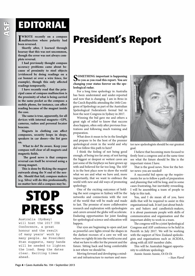
SOMETHING important is happening to you as you read this report. You are
changing your status forever on the spe-leological radar.
For a long time speleology in Australia has been understated and under-reported and now that is changing. I am in Brno in the Czech Republic attending the 16th Con-gress of Speleology as part of the Australian Speleological Federation’s formal bid to host the next Congress in Sydney in 2017.
Winning the bid gave me and others a great sigh of relief to know that success does happen, often only after previous frus-trations and following much training and preparation.
What does it mean to be in the limelight and prepare to be the host of the premier speleological event in the world and why did we follow this path to here?
I think the feeling of not being good enough, of being too far away, of not having the biggest or deepest or wettest caves are just some of the furpheys we have grown up with and believed for far too long. The ASF is in the best place now to show the world what we are and what we have and, more importantly, that we want to embrace the world with new and old ways of promoting speleology.
One of the exciting outcomes of hold-ing the next congress in Sydney will be the networks and connections with the rest of the world that will be made and made to last. The promise of more collaborative research and exploration with speleologists and cavers around the globe will accelerate. Enduring opportunities for joint funding for speleological science and education will happen.
Our eyes are beginning to open and just as powerful cave lights reveal the shapes in the darkest recesses of a cave we will see where we rightly fit into the world scene and what we have to offer for the present and the future. Sitting back and being comfortable is not where we should be.
Moving forward and developing a mind-set and infrastructure to nurture and men-
President’s report
tor new speleologists should be our greatest goal.
I believe that becoming more focused to firstly host a congress and at the same time see what the future should be like is the important vision I have.
That is the good news. Now for the bet-ter news: you are needed!
A successful bid opens up the require-ments for us to follow a path of preparation and planning that will be long, and in some cases frustrating, but inevitably rewarding. I will be assembling a team of people to help in this task.
You, and I do mean all of you, have skills that will be required to assist in this organisational task. It isn’t just about butch-ers and bakers and candlestick-makers, it is about passionate people with skills of communication and organisation and the important ability to work in a team.
The congress will be a joint Speleological Congress and ASF conference to be held in Penrith in July 2017. We will be working with the support of New Zealand speleolo-gists and organisations such as ACKMA, along with all ASF member clubs.
This will be Australia’s biggest opportu-nity to celebrate speleology.
Aussie Aussie Aussie, Oi Oi Oi —Stan Flavel
I WROTE recently on a compass malfunction where polarity had
been reversed. Shortly after, I learned through
hearsay that this was not uncommon, though the error was not always com-plete reversal.
I had previously thought compass accuracy problems came about be-cause of proximity to steel objects (evidenced by doing readings on a car bonnet or over a wire fence, for example), though this only affected readings temporarily.
I have recently read that the prin-cipal cause of compass malfunction is the proximity of what is being carried in the same pocket as the compass: a mobile phone, for instance, can affect reading because of the magnet inside the case.
The same is true, apparently, for all devices with internal magnets—GPS, cameras, radios and personal locator beacons.
Magnets in clothing can affect compasses, security loops in shops, speakers in car doors—the list goes on.
What to do? Be aware. Keep your compass well clear of all magnets and magnetic fields.
The good news is that compass reversal can itself be reversed using a strong magnet.
This is done by flicking the magnet outwards along the N end of the nee-dle. Should that fail, compass makers (e.g. Silva) will do this professionally, no matter how old a compass may be.
Australia (Sydney) will host the 2017 IUS Conference , a great honour and the result of many years’ work by many people. As President Stan suggests, many hands will be needed to lighten the load. Keep the dates clear. Exciting times ahead.
StoPPrESS

Caves Australia No. 194 • September 2013 • Page 5
CAv
E rESC
UE
DuRING the weekend of 10-11 November, the NSW Cave Rescue
Squad (NSW CRS), in conjunction with the Jenolan Caves Reserve Trust (JCRT) and the Ambulance Service of NSW (ASNSW) conducted a training exercise at Jenolan Caves.
This exercise was the third major exer-cise conducted at Jenolan in the past three years. During this time, the Squad has introduced vertical techniques based on methods currently used by many European cave rescue organisations. These techniques minimise the equipment needed to safely extract a casualty – a key consideration for any cave rescue given the potential difficul-ty and effort required in getting equipment underground.
The exercise provided an excellent op-portunity for members to practise these skills and work with the JCRT staff, who in an authentic rescue are likely to be first on the scene. During the 2011 exercise, two Special Operations Paramedics from the ASNSW attended as observers. In 2012, ASNSW was extended a formal invitation to participate and assigned two Specialty Casualty Access Team (SCAT) paramedics to participate in the Jenolan exercise. This facilitated the establishment of a valuable working relationship between the agencies involved, and further provided an excellent opportunity for inter-agency collaboration which proved beneficial for some members of CRS to learn additional casualty man-agement skills from the SCAT paramedics.
Careful planning of the Jenolan exercise was initiated several months prior to deter-mine the exercise objectives and to ensure minimal impact on the cave. The JCRT and National Parks and Wildlife Service’s Karst and Geodiversity Unit were consulted and kindly provided input during the planning process.
Central River is a regularly visited area of Mammoth Cave, frequented by adventure tours and caving clubs alike, and as such, was identified as a suitable starting point for the extraction exercise. Furthermore,
the choice of exercise location was ideal in that should a rescue be required from any point within the northern sections of Mam-moth Cave, an extraction along this section of cave would be necessary—although hopefully this situation never eventuates. Since the aim of exercise was centred on extracting an “injured” casualty, there was no need to undertake a search of the cave, thereby reducing our impact on the cave.
Other key measures for protecting the cave included defining the route throughout the cave using temporary track marking, as well as keeping movement in sensitive areas of the cave to a minimum. In particular, the area between Skull and Cross Bones and the Sugar Cubes was limited to all but the team responsible for patient management through this section. General access to the base of the Sugar Cubes was routed via the abseil down Davey Jones Locker (the extraction site of the 2011 exercise), and stretcher movements were suspended for the ~20 m between the top of the Sugar
Cubes and Skull and Crossbones.Justification for these limitations was
twofold. The primary intention was to pro-tect the sediment bank between Skull and Crossbones and the Sugar Cubes, which was likely to be eroded, particularly if a stretcher was hauled across it. Additionally, safety of all participants was paramount, as this section of the cave involves significant drops, and as such, members of the team tasked with the haul up the Sugar Cubes were attached to safety lines at all times. However, where possible, participants avoided this area altogether.
The exercise commenced with all par-ticipants attending an 8:00 am briefing at the Fire Shed on Burma Road, near the Cavers Cottage. After outlining the exercise objectives, assigning roles and responsibili-ties, and highlighting environmental and risk management considerations, the party proceeded down to the Playing Fields. At the request of the acting Cave Operations Manager (who attended the briefing), only
Jenolan 2012: Extraction from Central riverAndrew Baker, Michael Fraser and Al WarildNSW Cave Rescue Squad Inc.
A tyrolean was used to move the casualty down a section of the Railway Tunnel, enabling efficient handling of the stretcher
jOE
SYd
NEY

Page 6 • Caves Australia No. 194 • September 2013
CAv
E r
ESC
UE
the minimum number of four-wheel drives required to transport the necessary equip-ment were driven across the creek to Mam-moth Flat. A second briefing involving the four team leaders, SCAT paramedics, aboveground and underground control-lers, and the safety officer (overseeing the entire exercise) was held at Mammoth Flat while the other participants prepared to go underground.
The surface control was set up in the dry creek bed below the cave entrance and included the Michie phone base station, radio log sheets and a JCRT radio in case of emergency. A large fallen tree trunk on the edge of the surface control station provided an appropriate holding area by ensuring that anyone entering the cave was required to pass through a narrow area prior to ar-riving at the cave entrance. This proved convenient as a checkpoint for logging participants into and out of the cave; once a participant had passed the tree trunk they were deemed to have entered the cave.
The first team (Team 4) entered the cave at 9:10 am and laid the temporary track marking and Michie phone wire through the cave. This simple yet effective telephone system uses a single wire to send a signal, with an earth return completing the circuit. Apart from its simplicity, an added advan-tage of this system is that an operator can strip the wire at any point along the line and connect a Michie phone, thus allowing for communications wherever they may be needed along the line.
Each of the teams progressively entered the cave and commenced rigging their allocated section. The widely accepted principles adhered to in cave rescue include stabilisation of the casualty, and manage-ment of the scene and extraction path in preparation for the extraction (e.g. rigging haul systems). This is followed, when ap-propriate, by moving the casualty out of the cave in a smooth, safe and continuous manner. In some instances, it may not be possible to move the casualty all the way to the entrance, in which case a staging point is utilised; a location where the casualty can be kept warm, safe and comfortable until the next section of the cave is ready.
As the rigging preparations were nearing completion, the paramedics and casualty entered the cave. Obviously, in an authentic rescue, the casualty would already be in the cave (and hopefully the paramedics not too long after). However, given this was a train-ing exercise, unnecessary exposure to cold was avoided (in accordance with the risk assessment report for the exercise). As such the casualty and paramedics enjoyed what little sunshine there was on the surface un-til they were required underground.
Teamwork: manhandling the stretcher near Cold Hole
jOE
SYd
NEY
The stretcher at the base of the entrance pitch. Note that the tyrolean used to haul the stretcher up the first section of the Entrance Chamber has been released, enabling a vertical lift up the pitch
Communications are vital in any rescue. A Michie phone line from the base station provided communications through the cave. All radio calls and regular updates were logged by a radio operator
jOE
SYd
NEY
jOE
SYd
NEY
Jenolan 2012: Extraction from Central River

Caves Australia No. 194 • September 2013 • Page 7
CAv
E rESC
UE
The casualty was placed into the stretcher at Central River at 3:15 pm, and reached the top of the Sugar Cubes at 5:30 pm. At this point the casualty was removed from the stretcher and the extraction “sus-pended” until the empty stretcher was in the Railway Tunnel, thereby minimising damage to the sediment bank at Skull and Crossbones. In an authentic rescue, where human life takes precedence, it would be a straightforward exercise to continue the haul up this section of the cave.
A “new” casualty was placed in the stretcher in the Railway Tunnel for the re-mainder of the exercise, thereby minimising risk of the casualty being exposed to the cold and ensuring that everyone had an oppor-tunity to be involved in the exercise. By 6:00 pm, the new casualty was cocooned in the stretcher and manoeuvred on a horizontal “tyrolean” line up the Railway Tunnel, arriv-ing at the top of the Jug Handle at 7:30 pm.
In keeping with the previous two exer-cises, a ~40 m tyrolean was rigged from the Upper Entrance to an anchor near the top of the Jug Handle. Despite taking a while to set up, the tyrolean avoided the need for the stretcher to be handled over and under the numerous large boulders of the
Entrance Chamber. The lift up the tyrolean took a little longer than in previous years, mainly due to the trialling of several dif-ferent techniques (this was training after all), but nonetheless took less than half the time it would have taken to man-handle a stretcher up the Entrance Chamber.
The extraction was completed with the casualty arriving safely outside the Upper Entrance at 8:15 pm. Once everyone had signed out of the cave (i.e. been accounted for) the cave was locked, the communica-tions base station packed up and a quick debrief held at Mammoth Flat, since not everyone was able to stay for the in-cave debrief which would follow the next day.
At the conclusion of Saturday’s extrac-tion, Mammoth Cave was left fully rigged for a scheduled in-cave debrief on Sunday. This provided participants with an oppor-tunity to experience the route from end to end, with an explanation provided for each section, since most participants had only focused on the section of the cave to which their team was tasked. The cave was de-rigged and all equipment and track mark-ing removed on the way out of the cave on Sunday.
It is important to note that competent
cavers can reach Central River from the en-trance of Mammoth Cave without requiring vertical equipment in approximately 30-40 minutes via a traverse across the top of the Sugar Cubes or down the Unsurveyed Con-nection. With the exception of one or two minor pauses, the stretcher was generally continually moving, but took five hours to cover the same ground. This highlights the time and resources required to extract an incapacitated person from a seemingly straightforward and non-technical cave.
Overall, the exercise yielded a very suc-cessful outcome, with participants given the opportunity to practise numerous skills including stretcher handling, rigging skills, in-cave communications, and a variety of leadership roles. On a broader scale, the exercise significantly strengthened work-ing relationships between CRS, JCRT and ASNSW.
The NSW Cave Rescue Squad is plan-ning to follow up with another exercise at Jenolan in 2013, to be conducted in a different section of the cave. For more in-formation on the NSW Cave Rescue Squad, please contact Alison Fenton at [email protected] or visit http://www.ca-verescue.org.au/.
Jenolan 2012: Extraction from Central River

Page 8 • Caves Australia No. 194 • September 2013
EXP
lor
Atio
n
BACkgROUNdIn early 2000, Les Oldham, a British
geologist and caver living and working in Peru, noted a series of large open shafts in the Yauyos district of southern Peru that were taking the waters flowing out of Lago Pumacocha at the grand old height of 4400 m above sea level (asl). Nick Hawkes, an-other Peruvian-based geologist and caver, subsequently descended the first part of the entrance shafts and discovered that the cave continued beyond the daylight zone. This inspired three years of expeditioning to the region.
Speculation had arisen over the years as to whether major cave development at high altitude is possible, with early French, American and Brazilian-led Peruvian trips not being as successful as hoped. The com-mon theory was that the rain water falling at high altitude had not absorbed sufficient CO2, which in turn makes it acidic and speeds the process of cave development. Although the theory may still be correct, the 2001-2004 Yauyos expeditions proved major cave development at height was pos-sible by recording the deepest cave known in South America to be Sima Pumacocha at -638 m and Qaqa Mach’ay at 4930 m asl to be the highest surveyed cave in the world.
The Andes is the longest and second highest mountain chain on Earth, extend-ing over 9000 km through South America. It has formed above an active subduction zone which continues to push the oceanic crust of the Pacific beneath the continental crust of South America. This huge geologi-cal activity accounts for the line of volca-noes that intermittently extends along the length of the Andes and has caused older rock formations to be dramatically uplifted into their present positions. At Yauyos, our second target district, this uplift has been extreme and has caused Mesozoic aged limestone units to be largely pushed up into a vertical position and in some areas com-pletely overturned from their original flat lying depositional position. The typically vertical nature of the limestone beds has
had a massive influence on cave develop-ment in this area and the implication for explorers is that most of the caving is verti-cal in nature. However, with such extreme uplift, there remains potential for cave development at all angles. Another slightly concerning geological fact for cave explora-tion in the Andes is that this is a seismically active area; the mountains are still rising and earthquakes, not uncommon, have been known to be quite large.
Due to the high altitudes coupled with the extreme and remote conditions of the district, the alpinism alone involved in ac-cessing the caves is hard enough, and with Nick’s expatriation from Peru back to the UK in 2005, no further expeditions took place. The original expedition left going leads in a valley named Puyo and in the area that surrounds it. The reports and expedition members confirmed that there was lots of further caving to be done.
OUR ExpEdITIONIn 2004, the year of Nick et al’s last Pu-
macocha expedition, I was a young climb-ing bum living in Thailand, and couldn’t
afford the airfare over to Peru to join the expedition, though I followed the project with keen interest. A few years later, some of the expedition members whom I was caving with in Vietnam, New Zealand and Australia suggested that the project still held lots of potential but just needed some-body to put the wheels in motion. It wasn’t hard for me to find the drive and the basis of an international team and September 2012 was set for the expedition date.
Lima-based caver John Human was con-tacted and he put me on to another block of limestone with impressive-looking en-trances in the Cajamarca district in north-ern Peru. He photographed a huge river sink on the edge of the limestone contact which appeared to have 1 vertical kilometre of limestone below the entrance, and he promised us that more speleogenic lime-stone surrounded the ‘Tragedero Conga’ entrance. With Google Earth images, and good topographical and geological maps available due to the mining boom, we were convinced that the area was worthy of in-vestigation.
We split the expedition in half—three
Peru Caving 2012Andy MckenzieNCC (UK)
Back row: Andy McKenzie (UK/Aus) and Adam Haar (NZ) Middle row: RobertMiddleton (UK), Andrew Perry (Aus), Alan Warild (Aus), Jesse Martin(Canada), David Tabernackle (Dick) Front Row:
Nicholaus Vieira (Canada),Hannah Moulton (UK), Guillaume Pelletier (Quebec).
GU
iLLa
UM
E PE
LLET
iER

Caves Australia No. 194 • September 2013 • Page 9
EXP
lor
Ation
weeks to look at the Cajamarca area, and a further three weeks to follow up the Yauyos district. There would be a six-man team sent to the north, and we would add another four people, making it a ten-man team to visit Yauyos. The objective for us in Yauyos was to clear up all remaining leads in the Puyo valley and push out away from the Sima Pumacocha block. The team con-sisted of: two Brits, Hannah Moulton and Rob Middleton: two Canadians, Nicholaus Vieira and Jesse Martin: one Quebecois, Guillaume Pelletier: one token Kiwi, Adam Haar; one Brit/pseudo Aussie, Andy McK-enzie (yours truly); and three full-blooded Australians—the legendary Alan Warild, a young David Taberner and the random tight-wearing, hip-thrusting, Sydney party animal Andrew Perry. We hired two utes for the duration of the trip and camped in both districts, focusing our efforts on excel-lent acclimatisation to adjust to the altitude.
Nic, Kiwi and I arrived in Lima a week early to shop for the team, suss out trans-port, get access to maps and gather as much intel as possible for the coming six weeks. We also managed to drink copious amounts of the local beer and reek havoc on Lima’s otherwise quiet nightlife. Eventually, Guil-laume, Al and Dave arrived and we set off north in search of caving fame and glory. On arrival at the town of Cajamarca we met with a local geologist to gather as much information as possible about the Conga region. The most obvious and indeed seri-ous fact was that six kilometres to the south of our main lead was the strongly contested site of the Conga mine. The locals were ar-guing that the mine would take all of their local farming water for the mine processing and they would be left with nothing. After recent protests, angry clashes, some serious assaults and a few deaths—and all mining personnel staying well off the radar—up turn six white, badly-dressed cavers driving mining trucks, drinking the local supply of beer and stealing all of the local women (at least the French-speaking part of the team was trying their best to). We were imme-diately branded miners wherever we went; we would have to change this up a little if we were to have any hope of getting under-ground .
When we arrived at the Tragedero (Span-ish for ‘swallower’ or ‘swallet’) we quickly realised that there was a resurgence about 1 km away and 30 m below the entrance. The cave system seemed to just graze the contact. However, our interest was held by its many entrances and the fact that there were dolines everywhere heading up the hillside. The local family who farmed the land seemed to understand that we were indeed speleologists and not miners and
they graced us with a camp spot and spoke of entrances higher up the mountain.
The Tragedero was wet—very wet. We pretty much smashed all leads in the im-mediate cave between six of us in a day whilst trying to adapt to the altitude (3640 m). It was a good introduction to Peruvian caving, but given the present company, it was a little disappointing that it was a linear cave and had little vertical development. We spent a week or so acclimatising and slowly plotting entrances, subsequently knocking off the caves below. I had been interested in checking out a line of dolines 5 km to the east, so one morning Dave, Guillaume and I took a truck and went to investigate. As we mounted a col and started to descend into the neighbouring valley, people began to give us and our hired mining truck sideways glances. After some enthusiastic investigations of a long line of great-looking holes filled with ver-tical potential, our excitement mounting, we came across a roadblock in the form of the local padre and three extremely angry women. They immediately took us to be miners and started a torrent of abuse, ac-cusing us of stealing their water, polluting their land and taking away their families’ future. We spent an hour or two, with Guil-laume’s good Spanish, trying to explain that we were speleo enthusiasts and definitely not mining personnel. In fact, Guillaume and I are pretty staunch left-wing lads with anarchist ideals. If anything, our investiga-tions might help their cause. They didn’t buy it. The last thing one lady said trans-lated to something like ‘God will judge who you are. I’m going to get the boys. I’m going to get La Rhonderos.’ La Rhonderos loosely translates as a lynch mob, so with our tails between our legs, we turned the Hilux around and sprinted for camp. That night it was decided that with concern for the safety of the team, if we couldn’t push our inves-tigation east maybe it was best to leave the area. We decided to head back to the safety of Cajamarca town, have a wash and top up our supplies. We also needed to rethink our approach as tensions in the state seemed to be on the rise against the mine site. In Cajamarca we met the local head of tour-ism, Victoria Vilca Alfaro, who told us that the next state south, Cajabamba, had caves. It was en route to Yauyos, so the decision was made to at least check it out.
In Cajabamba we stayed a night with Vicky’s family while Dave and Nic took a local guide and went to check a lead on horseback. The area was immediately branded Brokeback Mountain, as Dave and Nic had to spend a night, cold and alone, high up on the hill, with little but each other for warmth. The lead was a dud, but set in
stunning mountain scenery. We had a great time with the locals and
Vicky pointed us in the direction of another limestone block a little further south. Here we explored an interesting system—El Chorro—which translates to ‘The Squirter.’ Nic, Adam and I started right away with the rock climb up the wall to reach the hole, while the rest of the team started to look at the surrounding area and set up camp. We boys returned early evening and reported the cave was still going. Trending upwards from the entrance, the cave was left at a small climb.
On the following day we broke into multiple teams. Exploration of the cave continued for some, while others scoured the nearby hills seeking further entrances. Adam and Dave pushed the cave, which continued in an upwards direction for a while before starting to trend downwards. As they continued surveying they started to encounter puddles of water for the first time. It went from puddles to walls covered with wet mud. There was a feeling a sump would be seen soon. Sure enough, it wasn’t long before they reached a 4 m pool of water, probably a hanging sump, but with-out dive gear we had no way of knowing. The following day a few guys returned to push a climb and see what was at the top. Although a lot of fun was had, no signifi-cant further passage was found. El Chorro was 700 m long.
The sump and dead climb marked the end of El Chorro’s exploration. Our contin-ued investigation of the hills nearby yielded little of interest apart from a 30 m long high cave full of ancient pottery. We were also told of Inca caves further down the valley.
Behind the mountain Adam and I found an incredible valley which held more po-tential than the El Chorro side. Eight caves/potholes were discovered—two with 7-9 second stone drops but enthusiasm for the area was dissipating for some expedition members. People were keen to get to Yauyos and set up a base camp. It is certainly pos-sible that a larger system does exist here and is likely that El Chorro is a pressure release passage when more water enters into the system than is able to escape via another method. However, without finding another way into that system we had to conclude our exploration of the area for this trip.
After a tourist drive past La Cordillera Blanca, we arrived in Yauyos five days ahead of the second wave of expedition members and marvelled at what we saw—perfect limestone cliffs from the valley floor, vis-ible almost all the way to the plateaux high above. This was cave country for sure, and we all knew it. We decided to head towards our leads in the Puyo valley that the 2004
Peru Caving 2012

Page 10 • Caves Australia No. 194 • September 2013
expedition had left—two going caves right on the contact 1600 m above the likely resurgences in the valley below. The GPS took us four-wheel driving into no man’s land where there were not even any tracks. We found a stunning valley at 4600 m with a 350 m climb over a col to cross to get into the Puyo. The valley became home sweet home as we set up our base camp at an old homestead. The local family had seen us cruise by their farm and sent their son out on foot to investigate who we were. Unlike the north, we found the southern locals to be extremely helpful—the farm boy, Abel, even showed us ten shafts—most with 6-10 second drops for rocks and he gave a prom-ise of hundreds more in the area. Caving time.
The team started to bash lots of pits and shafts. I drove a full day back to Lima to pick up the new recruits, soon discovering that even if Aussies are not renowned for much more than wrestling animals, An-drew Perry sure could represent with his drinking ability. Jesse, Hannah, Rob, An-drew and I filled up with beer and started the journey back to the 4600 m base camp.
For good acclimatisation it is advised to spend a night at around 3000-3500 m, then slowly advance sleeping altitude a maximum of 500 m per day from then on. Getting more altitude in the day is good, as long as you drop again to sleep no more than 500 m above the previous night’s stop. This ensures that the body starts to increase production of red blood cells to raise the oxygen carrying capacity of the blood to compensate for the lower levels of oxygen in the air.
My main aim for the Yauyos part of the expedition was to get everyone accli-matised to a high camp so that when they caved they wouldn’t be feeling the altitude as much as if they did day trips up from a lower height. This paid off for nine out of ten of the expeditioners. As I was already happy sleeping at 4600 m, even after a night of madness at sea level, I wasn’t concerned for myself, so I headed straight back to camp. The rest of the crew had done their reading and their time climbing above 4000 m in the past so we outlined a plan to get them to join us as soon as possible—and all agreed, apart from one caver who decided that 4600 m, with caves as high as 4900 m in the day wasn’t too big a deal. He jumped from sea level to 4600m with only one night in between, insisting there was no problem. After 24 hours we evacuated him down to 3000 m with serious symptoms of acute mountain sickness and high altitude pul-monary edema. He spent the next fortnight recovering, re-acclimatising and missing out on all the good caving. This pretty
much ended his trip and taught us all a les-son. It should be noted that the guilty party was not Aussie altitude veteran Andrew Perry, who was in high camp with us three days later happily drinking the team’s sup-ply of ale and whisky and bashing caves and mountains all day long wearing tights and doing strange dances.
When I arrived back at camp, part of the team had spent a few days bashing 100 m deep pits to the north. With 27 on their immediate hit list, they were slowly work-ing through the pits, hoping to find the one that gave them access to part of the bigger picture. The plateau sits to the north of the Puyo valley and it isn’t certain which way the water sheds. The geological maps are pretty good, but as per the background sec-tion above, the vertical bedding planes and crazy twisted limestone make the Andes hard to read from a caver’s point of view!
The main problems that the team were encountering was frost shatter, which is good at filling up holes and ways on, as well as being hard to rig past safely, and jugging 100 m plus back up the shafts, carrying gear, at altitude. Another part of the team had started to rig one of the going leads, Tragedero Puyo, whose beautiful entrance shaft was one to behold—and this was where I was headed immediately after my soiree in Lima.
This cave has a river sinking into its wide, 50 m entrance shaft and had been left at -107 m by some British mates of mine in 2004. Guillaume started to survey and I started to rig and push our way lower. At the bottom of the entrance shaft, the main way on seems to fill with frost shatter and an overflow system is followed—imagine JF-10 Splash Pot in the Junee (Tasmania), or a vertical Stockholm Syndrome in JF-382 Dissidence (Tasmania) or the nature of vertical caving in the Dachstein (Austria) at its worst and I still think the pitch heads in Tragedero Puyo are worse. Trying to negotiate vertical squeezes, and horizontal squeezes in the roof on to pitch heads with a bolting kit, three bags of rope and no mates was not my idea of an amazing time—get me back to caving in Vietnam. Remarkably, I had to remind myself to stop and breathe with every step. At around -130 m Guillau-me caught me up with his flash Palm/Disto X/Auriga survey tool and found me trying to negotiate the worst squeeze yet—vertical into freezing water. With some hammering from my trusty Petzl hammer and using a valuable drill battery we managed to get me down through the squeeze, but there was no way I was coming back. As I kicked around holding my breath trying to push the tight water duck I urged Guillaume to hammer the hell out of the squeeze and get ready to
pull me out. After some time we decided this was ridiculous. We were at -130 m in a serious vertical cave which happened to be the fourth highest in the world that day and we were digging a wet squeeze—time to call it an end. If this cave were elsewhere in the world I’m sure it would be dug as it deserves to be.
One hundred and twenty metres away and 15 m higher is the unlikely entrance of Cueva Puyo, which had been pushed to -60 m and left at a drafting pitch head by the 2004 crew. Their description of the cave was not too impressive and it was sidelined as a secondary objective to the Tragedero. As soon as Rob and I started to put rope on the pitches we were amazed at the size of passage and the draught coming out of the cave; it was serious vertical development that could be argued to be the main system of the Tragedero.
Following the old team’s single spits and marvelling at how sparing they had been with their rigging, we made our passage as safely as possible and got to their guessed 20 m pitch head—it was decent in size but there was a slope of scree directly above that made the approach and subsequent rigging more interesting. Below this we struck a 100 m pitch in a long winding rift but ran out of rope 40 m from the floor. We named it So Long And Thanks For All The Cave. We could see a possible way on but thought it best to leave the survey and all of the gear in situ and return to get more rope. On the following day, Al and Dave took enough rope to drop the next 40 m and check the bottom of the pitch. They arrived back at camp with a small climb lead in the early hours of the next morn-ing. The following day a pushing team and a photography team went in to push the cave and photograph what we had already found. The pushing team quickly killed the cave and the photography team managed to send a shower of rocks down the 100 m to kill Nic’s expensive Scurion light and break his little finger. This didn’t go down too well with the Canadian Viking.
In the Puyo valley, four other caves were explored, the most notable being Breath-lessness, which was a 60 m shaft just above the Tragedero. With four other large shafts explored by previous teams, we concluded that we could not find a way through the frost shatter and into the lower reaches of the limestone from this side of the hill.
To the north of camp the team was still knocking off shafts, caves and even a few mines each day. To the west and right near the road the team had noted some inter-esting karst with visible entrances dotted through. We also started to systematically knock through these leads in the hope that
EXP
lor
Atio
nPeru Caving 2012

Caves Australia No. 194 • September 2013 • Page 11
one would drop through the top 200 m of bad rock and into the good stuff. Some shafts were rigged directly off the front bullbars of the ute, Nullarbor style. Others were rigged traditionally with a bolting gun and naturals. All were great fun for the rig-ger. We followed a hardcore punk naming theme, with a complex system being called Suicidal Tendencies, an 80 m hanging death shaft Minor Threat, an 85 m shaft Bad Brains and so forth. The sum total of caves and features explored in the high camp area was 106. Some of these were complex verti-cal systems, some were 15 m pits. Bashing through them all was great fun and kept us busy for a fortnight.
On the day that the team member had to be evacuated to a lower altitude I had taken an exciting four-wheel driving trip up a side valley from the road—the true con-tinuation of the main river valley that the water from the plateaux rises in. In doing so I had noted some incredible limestone on the other side of the valley from where we had based our search and also got some information from local farmers that there were huge shafts 1500 m above their farm.
The rock was vertical and access from the east would be nearly impossible, es-pecially with heavy packs and camp and caving equipment. Nic, Guillaume and I decided to drive around the block to see if there was access elsewhere. From Huancayo township to the west we climbed from 3550 m to 4900 m in a day, with light packs and a thirst for finding these large shafts. We split up at a convenient point and divided the block into three. With six hours on the clock we worked hard to cover our areas and note any entrances. Guillaume and I were furthest east and didn’t find any cave or even decent limestone. Nic, however, found some fantastic speleogenic lime-stone, plenty of decent entrances and shafts and even a cave with worn limestone steps in a beautiful valley and Inca-aged skulls inside. The floor was worn throughout but unfortunately the cave had a collapse half way in which barred him from discovering why the cave had been so important to the ancient locals.
We reported back and it was decided that when it was convenient and when I had found two guys stupid enough to follow me up 1500 m of vertical ascent in a day with 25 kg packs, I would return to Nic’s area and push the leads. A video can be found on our website from one of the high peaks on this block which points out the area of interest and gives the reader a good idea as to what the Peru caving project is about.
http://peru.commscentral.netOn the same recce trip we discovered a
river sink, right by the road, which sucked
air. It was branded El Chupadero—The Sucker—and left for a return team. We also discovered two other blocks of limestone that would need to be checked by return teams.
Back at base camp the team was finally getting restless. Bashing a hundred pits and not being able to push past the frost shatter was getting frustrating, so we decided to pack up our camp and head for the leads that we had found on our outing. The first area would be Cerro Shacoc Machay, where we could do daily ute runs over the 10 km to the Lago Pucacocha area. When these ar-eas were ready to leave we would all head to El Chupadero and I would take a few guys to Nic’s block.
At Cerro Shacoc Machay we started to piece together a large cave system spread out over the hillside. Up on the Cerro itself, a number of collapse features were noted, and all the ‘going’ shafts ended in the typi-cal sediment/breakdown chokes we had be-come accustomed to finding. It seems that if you find a shaft or series of shafts extending below -150m from the surface,you might have a chance of getting into something more extensive than the choked shafts we had been recording.
The most notable shaft explored was Megadeath at -76m. There are hints of a ‘master’ cave of sorts, but there will not be an easy way in, if there is one. Cerro Shacoc Machay would be a fantastic caving area anywhere in the world that would produce numerous discoveries and education, but with the limited time afforded to expedi-tions it is unlikely to yield the results hoped for without a lot of hard work. The area is perfect for teaching about cave and karst development as it displays many of the nu-merous ‘textbook’ lessons, such as migra-tion of sinking stream. It was a joy having
trekked over Cerro Shacoc Machay, and we felt lucky to learn from it.
The block to the west—the Lago Pu-cacocha area—kept four men busy for five days. The bedding of the limestone in this relatively small area had a general incline of 20-30 degrees. There are numer-ous sinkholes along the presumed contact zone in the bottom of the valley, extending for the entire length we walked. Given the amount of sediment in the area, it was not unexpected that most of the sinkholes were blocked, though some contained rounded boulders made of igneous rock of glacial origin. Along the ridge almost nothing was found; however, a line of entrances was found near the top of the mountain follow-ing a fracture line.
One significant cave was discovered in that line of entrances. It dropped almost completely vertically through the bedding planes to a depth of -100 m. The way on at the bottom was blocked by huge break-down, but a large standing passage could be seen to continue at the angle of the bedding plane through the boulders. Any future trips to this cave would require micro-blasting gear and some tools to move boul-ders. A strong draught was detected higher up in the shaft but it is lost in the large room at the bottom. It is still possible that there is parallel passage along the shaft that bypasses the breakdown. Numerous nooks that bent out of sight lined the shaft all the way to the bottom; just another area that elsewhere in the world would be dug and probably reveal something more involved.
We headed for El Chupadero, which turned out to be a complex, fun system. It went for nearly a kilometre and kept seven people busy for the best part of a week. The system climbed, dropped, twisted and began to get quite complex with side pas-
EXP
lor
Ation
Peru Caving 2012
Standard afternoon weather in the mountains
GU
iLLa
UM
E PE
LLET
iER

Page 12 • Caves Australia No. 194 • September 2013
sages, inlets, oxbows and avens. We had a good bolting project in there and some horrendous squeezing and hanging death boulders in the side stuff. The cave eventu-ally ended in a choke, but the side leads kept us busy trying to tie off the survey.
Whilst this was being explored I had been hunting the team for two people to come on a three-day jaunt up to Nic’s block above Huancayo. Kiwi Adam was easily persuaded as he didn’t really understand what he was in for, so he was an easy choice. The third man would be Australian Andrew Perry, whose trekking and mountain climb-ing history, bravado as a tough bloke and lovely long legs would make him a great addition to the small team.
We set off from 3550 m up a steep climb, up a short rock climb and on to the plateau.
At 4850 m we crossed a col and dropped into the beautiful valley where Nic had dis-covered the Inca cave. We made a bivouac, ate some food and promptly fell asleep. On the following morning we set out to start knocking off Nic’s leads. That day we all got more than our fair share of caving, with five decent potholes rigged and killed—two were over 100 m deep but there was still no way into the lower reaches of the lime-stone. The area holds potential and would be worth a return trip. It is truly a beautiful part of the district. We ended the long day with a starlit walk back over a 5000 m peak and back to our lonely bivouac.
On the following day we woke early again, packed up our stuff and headed back towards the col, where we dumped our kit and set off once again for an epic vertical
climb to a ridge where Nic had spotted a 15 m by 8 m entrance high up. As we ap-proached the ridge we were uncertain of the location of the entrance so Andrew went one way, I went another and a shattered Adam sat and waited on the ridge. Andrew found three entrances that didn’t go far and I was lucky enough to find and survey the second highest cave in the world, Puna Mach’ay or High Valley Cave, which didn’t really hold much potential as it was high on the ridge, but the approach across vertical scree and the rock climb into the entrance made it an exciting outing. We decided that a quick scree run descent to our packs and a long, slow downclimb to Huancayo where cold beer awaited us was overdue.
After a night on the beer and playing soccer with the locals at a lowly 3500 m
EXP
lor
Atio
nPeru Caving 2012
Rob surveyingBolt climbing in El Chupadero
The bottom of So Long And Thanks For All The Cave! pitch
GU
iLLa
UM
E PE
LLET
iER
GU
iLLa
UM
E PE
LLET
iER
GU
iLLa
UM
E PE
LLET
iER
Caves Australia No. 194 • September 2013 • Page 13
EXP
lor
Ation
it was time for David and Alan to head back to Lima and start their journey back to Sydney. The rest of us had a few more days and a going cave called El Desnuda-dor, which sat under the huge Canete river and followed a line through tufa and not limestone. This cave was a real surprise to everyone involved. It was found by chance in an unexpected location and does not have a limestone wall in the whole place. Despite, or rather because of this, and its exceptionally aqueous and sporting nature, the cave was a real treasure late in the trip. The first explorers also ended up doing it in the nude—they had no caving gear and didn’t want to get their clothes wet, but they were just too excited to wait. Truly unique.
An entrance had been spotted on the far side of the tufa dams on the Rio Canete
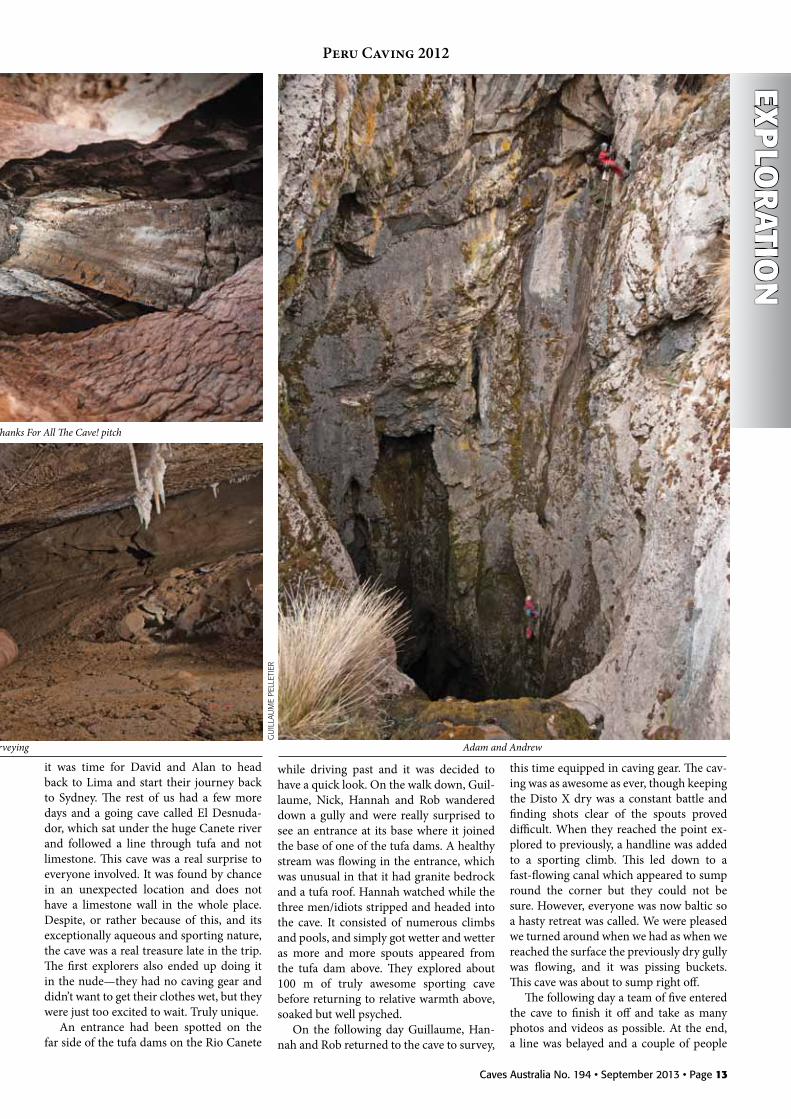
while driving past and it was decided to have a quick look. On the walk down, Guil-laume, Nick, Hannah and Rob wandered down a gully and were really surprised to see an entrance at its base where it joined the base of one of the tufa dams. A healthy stream was flowing in the entrance, which was unusual in that it had granite bedrock and a tufa roof. Hannah watched while the three men/idiots stripped and headed into the cave. It consisted of numerous climbs and pools, and simply got wetter and wetter as more and more spouts appeared from the tufa dam above. They explored about 100 m of truly awesome sporting cave before returning to relative warmth above, soaked but well psyched.
On the following day Guillaume, Han-nah and Rob returned to the cave to survey,
this time equipped in caving gear. The cav-ing was as awesome as ever, though keeping the Disto X dry was a constant battle and finding shots clear of the spouts proved difficult. When they reached the point ex-plored to previously, a handline was added to a sporting climb. This led down to a fast-flowing canal which appeared to sump round the corner but they could not be sure. However, everyone was now baltic so a hasty retreat was called. We were pleased we turned around when we had as when we reached the surface the previously dry gully was flowing, and it was pissing buckets. This cave was about to sump right off.
The following day a team of five entered the cave to finish it off and take as many photos and videos as possible. At the end, a line was belayed and a couple of people
Peru Caving 2012
Rob surveying
The bottom of So Long And Thanks For All The Cave! pitch
Adam and Andrew
GU
iLLa
UM
E PE
LLET
iER

Page 14 • Caves Australia No. 194 • September 2013
EXP
lor
Atio
n
floated off down the canal in search of the continuation. This was definitely sumped and photography began. An excellent end to the expedition.
After a recce for Nic and me into the higher valley of the Canete River, and with one of the best leads of our caving lives left for another year, we were ready to head back to Lima, get a shower and get some beer and non-camp food inside us. With Andrew and me representing Australia, two Poms representing England and three Canuck womanisers, we hit Lima in true expedition last-night style.
I vaguely remember taking one of our high-powered executive contacts from one of Peru’s top mining companies into a death metal club late in the night and stage diving off a high balcony, but nobody could
confirm much about that night the follow-ing day.
In conclusion, Peru 2012 was a great success in that we went to recce two dis-tricts and ended up looking at three. The world’s highest cave list was reinvented in the time that we spent there and all expe-dition members learnt a lot about caving, altitude and mountaineering. Australia was represented by five men from Sydney as part of a wider international community and although we didn’t break through into the lower reaches of the Yauyos block, we did systematically check all leads and leave no questions for further teams. Putting a team together from different parts of the world and from different generations was fun and we all learnt new ways of doing what we do. Most expeditions I have been
part of have been solely British, Kiwi or Australian and it was great to be part of the wider community and learn from it. We plan to return to La Canete valley to check our big lead there and perhaps look more at the lower valley’s resurgences and low entrances in the future. The Conga area remains a disappointment but holds some great caving potential in a country overtaken and disrespected by large foreign mining companies. As Australians. we can relate to Peru well.
To read our final detailed report, check out surveys and view more photographs please visit http://peru.commscentral.net
[Written by Andy McKenzie. Credit, in part, should go to Jesse E. Martin, Nicholaus Vieira, David Taberner and, of course, the team.]
Peru Caving 2012
Rob in El Desnudador
Moving through El Desnudador Rob doing what he does best
Al Warild
GU
iLLa
UM
E PE
LLET
iER
GU
iLLa
UM
E PE
LLET
iER
GU
iLLa
UM
E PE
LLET
iER
GU
iLLa
UM
E PE
LLET
iER

Caves Australia No. 194 • September 2013 • Page 15
ON 6th October 2011, a remarkable thing happened when I decided to
revisit a muddy pool of water I had last looked at almost ten years before.
The pool was in the entrance chamber of Olwolgin Cave where 2,700 m of cave diving passages have been explored and mapped since it was first dived in 2002 by me and Andy Nelson (CEGWA). While all the diving and exploration was being done from the ‘main’ (north-east = upstream) pool, the ‘other’ (south-west) pool had been ignored.
At the bottom of the ‘other’ pool, an awkward restriction was negotiated which led to a further 80 m of silty and reasonably small cave-diving passage. Later that same afternoon, with full 7-litre cylinders and reels of knotted guideline, my primary dive buddy, Alan Polini (CEGWA) and I extend-ed the new line straight into large phreatic conduit for several hundred metres with no end in sight. Turning on our thirds, we left an exploration reel tied off to the top of a large rock in the middle of a big tunnel.
While surveying back out of the cave, several substantial side passages to the south were noted. There was disbelief around the campfire that night as Alan and I excitedly relayed our discoveries to the rest of the group. Sweet dreams indeed that night, and many more since.
ExpLORATION IN EARNESTThis discovery was made at the end of
a Roe Plains sightseeing trip with Brian Kakuk (Bahamas), Ken Smith, Richard ‘Harry’ Harris and Grant Pearce (all CE-GSA).
As Alan and I had to drive back to Perth the following day, they prepared for one more dive in the new cave, but only after Brian and Ken had dived next to extend the line, and more importantly, retrieve Ken’s reel still in the cave.
On the next morning, Brian and Ken ex-plored several hundred metres of the main conduit (A Tunnel) and when they turned around on their thirds, Ken reported, ‘I
was so overwhelmed by what we had just done that I was shaking with excitement, so much so that I couldn’t hold my pencil steady enough to write down the survey data, so Brian had to do it for me.’
As soon as Brian and Ken were clear of the water and it was obvious that extending the main conduit would require stage bot-tles, Alan and I headed in, laying over 400 m of line in side passages they had noted that were to become the C and D Tunnels. A gas failure (free flowing 2nd stage) expe-rienced by me at the furthest penetration of the C Tunnel (600 m) during this dive meant that no survey data were collected.
While Alan and I drove back to Perth, Harry and Grant extended the main tun-nel using stage bottles to a penetration of over 800 m with the passage continuing, although it had reduced down to a much smaller, side-mount-only sized tunnel.
Ag’S dREAMTIMEBefore the rest of the group headed for
home, Brian Kakuk was to make a sensa-tional discovery while checking side tun-
nels at a penetration distance of 400-500 m. After pushing through a small, non-obvi-ous side tunnel for 20 m or so, the passage opened into a tunnel of generous propor-tions: 10-20 m wide and 3-5 m high. This stunning cave-diving passage continued for almost 200 m before Brian had to turn on his thirds, where he tied off on a rock in the middle of a large, continuing passage.
On Brian’s suggestion and with the ap-proval of her family, the passage was named after Australian cave diver Agnes Milowka, who had tragically died in a cave diving ac-cident earlier that year.
Brian had this to say shortly after his discovery: I was hoping to maybe name that big passage Ag’s Dreamtime Tunnel, or something along those lines.
I was thinking about Ag while I was swimming down that borehole, wishing she was showing it to me.’
And so it was that during three days of diving in early October 2011 over 1,400 m of diving passages were explored and sur-veyed following the initial discovery.
There were three main leads, each con-
roe Plains, WAolwolgin Cave revisited (Part 1)
paul HosieCEGWA
EXP
lor
Ation
Alan Polini (left) and Paul Hosie after their dive on October 7 2011
PaU
L H
OSi
E

Page 16 • Caves Australia No. 194 • September 2013
tinuing in parallel passages to the south-west with penetrations of 600 m (A), 800 m (B) and 550 m (C).
It was realised from the start that this was potentially a very large and complex cave system and therefore I established strict requirements for surveying and sta-tion numbering by the exploration teams, which is why I am referred to by some as ‘Sergeant Major Survey.’ Following the initial exploration hiatus, the passages were labelled according to their potential for continuation.
CEgWA CREW RAIdIt took little encouragement for a re-
turn trip (‘The Raid’) to be organised by a small crew of keen CEGWA cavers and cave divers for a four-day long weekend in late October 2011. Kim Halliday and Craig Challen paired up as a dive team with us, possibly over-enthusiastic with our rebreathers and scooters ready to explore caverns measureless to man. The four div-ers were brilliantly supported by Christie
Allen, Mark Brown and Jeff Gibson; they looked after everything around the camp and the cave so that the divers could focus on the cave diving.
Given the zero visibility and awkward-ness of the first 30 m of diving through the entrance restrictions, a thick rope donated by Craig was fixed in place by tent pegs and weights, thus improving the situation mas-sively.
The next piece of infrastructure to be put in place was a staging area, which was brilliantly set up by Alan 80 m into the cave. The staging area consists of a rope fixed horizontally to the side wall with several hanging lines, each having several D-rings on it to clip off scooters, stage bottles, re-breathers etc.
Owing to a few equipment problems and the fact that Ag’s Dreamtime Tunnel shut down a further 70 m beyond Brian Kakuk’s tie off, only 600 m of passage were explored and surveyed on this Raid trip, but there were still a couple of leads at the end and many side passages marked for exploration.
EXP
lor
Atio
n
On the last dive of this trip, a significant discovery was made at the end of the B Tunnel by Alan and me—The Sanctum, an 80 m long, 20 m wide, 2 m high room/pas-sage which had further leads to explore but was now over 900 m from the entrance and only accessible with sidemounts.
The next visit was during Easter 2012 involving Alan Polini, Grant Pearce, Chris Edwards (CDAA), Ken Smith, Liz Rogers (VSA) and me.
A significant event occurred early dur-ing the course of our diving when some-thing shifted in the entrance restriction whilst four of the divers were in the cave. Owing to the zero visibility conditions we couldn’t be 100 per cent sure what had hap-pened, but we believe the Letterbox rock (a big chunk of several hundred kilos) had shifted into a new position.
This shook us up a bit and stopped us diving for a few days until we were confi-dent that the situation was stable and it was safe again to enter.
We added only 700 m to the survey on this trip, bringing the total Downstream passage length to 2,700 m. The most sig-nificant discovery was made by Grant and Chris when they extended the B Tunnel line to the south-west from The Sanctum and entered an enormous room which proved to be 130 m long, 30 m wide, 3 m high with a completely flat roof at -4 m. Subsequent visits have shown that this remarkable room can be accessed from five different passages around its perimeter, hence the name Grand Central.
CAVE dIVINg CONSERVATIONI have written several articles and given
presentations to the Australian caving and cave diving communities regarding the uniquely fragile features found within the
Ken Smith (left) and Brian Kakuk after their dive on October 7,2011
PaU
L H
OSi
E
PaU
L H
OSi
E?Pa
UL
HO
SiE
Roe Plains, WA: Olwolgin Cave Revisited (Part 1)

Caves Australia No. 194 • September 2013 • Page 17
EXP
lor
Ation
Roe Plains caves. The basis of this claim is that the most fragile features are organically based, rather than mineral or crystalline as found in other cave systems.
Whereas in dry caves it is the spe-leothems that warrant the greatest con-servation and protection efforts, in these underwater caves it is bacterial colonies, threadlike tree roots and tree tap roots that predominate.
These features are very spectacular, with some of the tree roots hanging in drapes up to five metres long. They are incredibly fragile because they are decaying—rotting and breaking down—and this makes them highly susceptible to damage from div-ers’ exhaust air bubbles, fin kicks or body movements.
It is fortunate that the exploration of Ol-wolgin Downstream has been done follow-ing ten years of exploring and mapping of the Roe Plains caves—Olwolgin Upstream and Burnabbie Caves.
This experience has enabled the explora-tion team to identify the fragile features and place the guideline so that divers, including themselves, avoid damaging them.
This strategy is supported by floating
Olwolgin roots
RiC
HaR
d H
aRRi
S
reflectors and signs that identify the fea-ture and ask divers to swim directly above the guideline for a short distance around it. And so it is that underwater track marking has been implemented with the hope of conserving these unique and spectacular
features for future generations to enjoy.In Part 2, we will continue the story of
the exploration of Olwolgin Downstream Cave and provide the most up-to-date sta-tus of the work being done there.
Roe Plains, WA: Olwolgin Cave Revisited (Part 1)
Front (left) and back of conservation alert signs

Page 18 • Caves Australia No. 194 • September 2013
EXP
lor
Atio
n
THIS IS a condensed account over many trips.
For those unfamiliar with Jenolan, there are three main rivers that converge from the north, the south and the west in the Grand Arch, a large chamber through which tour-ist buses and through traffic pass every day. About 250,000 people visit Jenolan each year. The northern (Jenolan Underground River) and southern (Styx/Lethe rivers) are underground but the western river flowed above ground in the past, sinking just prior to the Grand Arch, perhaps joining into the Jenolan Underground River, perhaps in Chifley Cave somewhere. Something to be looking at. Now the western river runs through a concrete drain straight into Blue Lake. The Grand Arch, I conjecture, may be the result of corrosion mixing from these chemically different water courses, but of course it is all fairly complicated.
The river from the south exits at Blue Lake and was thought to be seen in Lucas and River Caves. The waters we see in Lucas and River Caves’ Pool of Reflections are now known to be anabranches of the Styx/Lethe river but taking water from what is possibly another smaller river lying under the giant Lucas Cavern. In the tourist caves the only true part of the Styx River is seen at Twin Bridges, a section of river notably where historic guide J C Wiburd was pho-tographed, standing a little stooped with his cane and looking uncomfortable with the photograph. This is an iconic section of cave, and an admirable place to be photo-graphed.
Under the spectacular chamber in Lucas is a group of muddy passages known as the Mud Tunnels. In one place there is a drop to water, the Lethe Hole. Pools on each side of a narrow gravel floor are, it turns out, the only true body of the Styx/Lethe river seen in the tourist caves.
This part of the water was called Lethe in line with the rivers-of-hell theme and so-named before being recognised as the main underground river and exiting as the Styx into Blue Lake. From the tourist pathway,
to the right it passes through a spectacular dive, then a passage known as the Long Low Horrible Flat Thing to emerge at Twin Bridges and then on to Cerberus Pool be-fore finally emerging into the outside world at Blue Lake. What a dive—it’s a classic that needs to be on the ‘Been There, Done That’ T-shirt.
Over the years SUSS explored and mapped the river from Lethe’s start all the way through to Blue Lake. It took years of work, largely by Greg Ryan and me, to survey the route finally rendered in map form by the great SUSS cartographer Philip Maynard.
In the other direction from Lethe Hole we know the water connects to Barralong. When Barralong was discovered in the 1960s by Jenolan guides it doubled the southern reach of Jenolan Caves. The most northerly end was found to end in an over-flowing lake dived in the 1970s by Peter Rogers and later many times by SUSS.
We knew nothing about what was be-tween Lethe Hole and the furthest reaches of Barralong to the south, other than that they are connected. In reviewing the dive south, recall that the dive begins in the backmost lake, descending through a hole in the bottom of a lake. The downward pas-sage received up-flowing water and tends
to push granular pebbles and deposit them on the upward slope as it rises into the Bar-ralong Lake. On one trip Michael Collins and I spent an entire dive with no objective other than to scoop the pebbles off into the sides and out of the way in an attempt to make the southern passage navigable. It was highly successful, turning a difficult squeeze passage into a highway.
The onward passage makes its path though a number of jointed rifts, passing under a rift slot. The top of the slot is a tun-nel, accessible to any wet and bedraggled caver after climbing a muddy cliff on the far side after swimming across the Barralong Lake and climbing the impossible cliff on the other side. Somehow, someone in the past did it and left an ancient metal ladder. At one time we climbed the ladder and started our dives at the slot. All too hard, really.
The dive onwards from the slot zigzags through keyhole tube obstacles negotiated by turning from one side to the other and sliding side-mounted tanks one way and then the other through each impediment; these are not really squeezes, but neverthe-less they slow you down a bit. The keyhole-shaped tunnels are at about 4 m depth, occasionally surfacing in small airbells. The shallow passages descend suddenly to
Jenolan Update 2Barralong and the missing linkkeir Vaughan-TaylorSUSS
Katrina Badiola searching for the Missing Link during the flood
kEiR
vaU
GH
aN-T
aYLO
R

Caves Australia No. 194 • September 2013 • Page 19
EXP
lor
Ation
15 m, presenting a path of several fractured rifts, one of which was somehow fortuitously located through zero visibility, rising to the surface through a tight vertical rift.
The surface presents as a small lake and a stream cascades into the lake from a crawling-sized tunnel off to one side. While the dive is cold, the crawl along the stream tunnel is obstructed by sharp blades of limestone. In full neoprene and dangling dive tackle, this onerous crawl regenerates feelings of warmth but no love for sharp limestone.
There are two or three short sumps with adjoining air spaces. I intend in future to make sure that none of these rooms has leads. I am sure I have checked them but we are always focused on the far point of explora-tion and now, in the comfort of home, I am unsure how well we have searched here. From the last of these rooms there is a tight and short exit rift and then at right angles an intersecting rift perhaps 1 m wide.
The room has vertical walls, providing no rest place out of the water. This rift pool is 6 m deep. At the bottom, a rounded tunnel with an emerging water flow is blocked for divers by sandy floor. Scooping and digging sand out of the floor is possible but there are limited places to put the excavated material. A flood might one day do the excavation for us. I find you get more wishes granted if you wish for things that are likely.
This rift may be the way to the Great Southern Limestone. The dive to this place is not easy. Time spent at this place is limited by cold and also the en-durance of the support team, with motivation waning after many hours of waiting.
Back in the warmth of the Cavers’ Cottage, the post-examination conversation mixed with wine, port and a good meal tells us there is something there: we just need to go back again with a bottle of port.
Phil’s maps (perhaps I should say the SUSS maps) show the underwater section to be directly under where the snout of a mountainside descends to the valley floor, near a small karst feature known as Hob-bits Hole. In my early caving years Mike Lake took infantile delight in enticing new SUSS members to squeeze with some difficulty into the entrance of Hobbits Hole. Beyond the squeeze is a small domed room that then goes nowhere, but is made slightly more interesting with the signatures of the early guide explorers Voss, Wiburd and Edwards.
Facing up the valley, the underground river’s position stops short of showing if the underground waterway dives under the mountain on the left or crosses the valley to the right under Block Cave. Block is mostly vertical, dropping under the right-hand mountain. There is not much in it. As a young caver I climbed down confidently but looked back up its vertical shaft to encourage a young lady uncomfort-able at making the climb. As I called my expert advice and encouragement she knocked a small stone off the climb into freefall, breaking half my front tooth off. Expensive business, dentists.
We have yet to find how the Southern River is related to the spectacular Bottomless Pit on the right side of the valley. Contrary to its name, the pit does have a bottom. In the past we descended the multiple PH
iL M
aYN
aRd
Jenolan Update 2: Barralong and the Missing Link

Page 20 • Caves Australia No. 194 • September 2013
EXP
lor
Atio
npitch hole with ladders. With much less environmental impact, we do the trip these days as a multi-belay SRT trip. At its bottom in a big chamber you can stand next to a huge fallen boulder, hearing and feeling a strong breeze emanating out of the craggy floor, suggesting a huge cavernous pres-ence—something else that you just can’t get to.
A lot of work has been done this year in the Southern Limestone, mostly by Rowena Larkin. She has relocated many caves and found a lot of small new caves with some potential. The back of Barralong somehow relates to a huge valley and underground river system, yet to be discovered, travers-ing about four kilometres all the way to Paradox Cave .
After saying the big adventure is to the south we then instead focus inwards. On one dive trip to Barralong Lake, instead of pushing south, I investigated the river go-ing the other way—north, back towards the tourist caves. The story that had been told to me was that the downstream river flow-ing out of the Barralong Lake flowed into an impenetrable rock pile.
On the contrary, there is a short sump followed by a canyon passage with knee-deep water where you wade and stagger along stream passage and then another sump followed by more canyon stream walk and another sump. Awesome.
The canyon ends at a steep slope of jagged rocks at the edge of the water. A chamber some distance up the tumble of rock meets the roof. Unfortunately, the room which can be seen beyond is obviously unstable. To this day, no-one has mustered the bra-vado to explore the room at the top of the slope but perhaps, with care and judicious rock moving, it could be safely negotiated. I will leave that to future generations; we have to leave something.
Michael Collins found a way to avoid the Cavern of Doom by further squeezing be-tween rocks that were tumbling out of the Cavern and lodged against the wall where the ongoing canyon used to be. A nice piece of ‘reading the cave’ that I should have rec-ognised myself.
After another few metres the passage opened to a set of small chambers full of collapsed rock pile and loosely connected with eroded keyhole-shaped channels. Water flow belonging to River Lethe could be seen though fissures in the rocks. Jason Cockayne, with a catenary smile, is cap-tured in an iconic photograph squeezing about in rock piles trying to get back into that water.
Michael concentrated much effort visit-ing this area with scaling poles and climb-ing gear to scale an extremely muddy aven.
Each trip required lots of SUSS help and the usual extra efforts to prevent damage to the floor and formations on the trip through Barralong. The climb finally yielded an uninspiring room with a small amount of decoration. Oh well.
So some progress. ‘…though much is taken, much abides.”
Phil, Katrina and I, and others, planned to explore during a flood in the hope of finding signs of a flowing river somewhere in the rock piles. The unlikely prospects of such a plan is compensated for by the rush of being in the cave almost cut off by flood, just accessible with swims and breath holds.
The starting series into Barralong begins in an undeveloped tourist section of the Mud Tunnels. The way passes through a rock pile that exits to a steep gravel phreatic tube that is just great for photographs and at the bottom, what I regard as the entrance to Blue-tongue is in a rain event flooded to the roof.
For our trip the entrance to Blue-tongue was almost flooded, only just a chilly breath hold. There was a small airspace to give you confidence. Ted had no problem at all but perhaps that was peer pressure; you’d think he was old enough to know better. Beyond, one person climbed the 6 m Blue-tongue Pitch and lowered a ladder for our team to make it into a room that is just prior to where Barralong assumes the decoration for which it is so revered.
In this flooding situation water surged inside fissures and grikes, pouring out of some holes and into others. Tantalising sounds seem to move as you move within one of the rock piles. Slots and rifts, in this flood, hosted perched streamways. A can-yon normally dry now had to be waded and then swum along. It forked one way, ending in a blind passage. The other way led to a 2 m drop, over which water poured from its perched stream into a small lake room, waist-deep and suitably cold.
Within the lake, part of the river was welling up on one side of the room, swirl-ing around and down into another hole. Heavy boulders weighed less in the water compared to non-flood conditions and in a co-operative effort of pushing and lifting we could move some substantial rock blocking where the water came from and also where it went. With a blurry underwater entrance exposed, we tried putting my cheap ‘water-proof ’ camera into the inflow and outflow holes and captured an image of what lay beyond. The pictures were poor. Neverthe-less, they showed that there was quite a bit of room in both holes and we were inspired to come back with two 3-litre scuba tanks to have a look under the surface.
Information from the photographs was
to prove unnecessary and so was the pro-posed dive. I had imagined the upstream and downstream holes as being the missing link between the dive upstream back this way but it was to transpire that both holes were not possible to dive. However, it did turn out to be the missing link.
At a later non-flooding date, a survey team went to the Missing Link to sur-vey the significant places in the perched streamways where we were now sure the river lay close by. With the flood receded the stream was gone. The perched streams were dry and the holes where water welled up from below were also dry. Now, with ob-stacle rocks moved aside, there was passage beyond.
The survey team followed the dry pas-sage and found that upstream, heading to-wards the diving push caverns, there was a connection. In all those diving trips no-one had noticed the insignificant hole in the floor where this lead connected in.
Having missed the survey trip, I later returned with a smaller team just to have a look and see if there were more leads. The route to the diving chambers is a crawl over fragmented rock. It is a tight squeeze in places, but not hellishly so. There is a chance of other passage inside the rock pile but nothing easily presented itself. Does it ever?
Crawling through these small chambers the southern river can be seen trickling across river gravels through a lower, very small passage underneath. The flow does not seem to represent the entire flow. We know that part of the flow passes under-neath the Blue-tongue Pitch and into Blue-tongue Pool. Even so, there may be more. Another part passes through alluvial grav-els, emptying into the Blue-tongue Pool.
The river is unknown between Blue-tongue Pool and where it next appears in the Mud Tunnels, some distance prior to the tourist favourite, the Pool of Reflec-tions. Downstream from the Missing Link, the distance where it connects into Blue-tongue Lake is not very large. However, from there there is a 6 m difference in height represented by the Blue-tongue Pitch where once, long in the past, the water dropped. It now drops somewhere else. The water must make the same fall, but possibly over a yet-to-be-discovered waterfall.
No doubt the previous survey group checked it out; nevertheless, I wanted to inspect what I could. Struggling into the hole, I was able to squeeze downstream. For a short way a small stream trickles across stream gravels underneath the crawl tun-nel—not the main flow by any means but very interesting. At a most awkward tight spot I could see a streamlet filtering be-
Jenolan Update 2: Barralong and the Missing Link

Caves Australia No. 194 • September 2013 • Page 21
EXP
lor
Ation
tween stones packed in a rock pile. In high water conditions the water would back up from this point and create the lake condi-tions we had previously seen. It would not take much to move the filter stone aside, but it would take a smaller person than me, with much better knee pads and in a much more determined mood.
It remains to be seen if this new route can change the time and effort for diving the Southern Barralong’s waters, but in any event this is a far more environmentally friendly route to the back of Barralong. This potential route is low, confined and with sharp rocks lining the route. I really need much more industrial strength knee pads. There are sections demanding lying down, crawling and grunting through sharp rock and a low roof. After the crawl section continuing on to the very back there are multiple short sumps, a stream gravel crawl and an irritating climb along a rift with a limestone blade running the length of it. At least it opens right at the end facing into Barralong’s famous overflowing lake chamber.
On the positive side, there is no forma-tion to worry about. There are no cliffs to pass gear up and down and the possible impact on decoration is eliminated. As an air-saving safety measure the short sumps joining each of the river canyons might be best passed using small pony bottles before changing to 7-litre bottles at the Barralong Lake. So, with a substantial improvement to our access to the very back of Barralong, we are now diverted by a significant discovery back right at the start of Lethe in the Mud Tunnels—the unknown section between the Lethe Hole and Blue-tongue.
The upstream side had been pushed and prodded and each time yielded just a little more. Eventually, in August 2012, Rod O’Brien passed Lethe’s vertical squeeze us-ing a setup of lightweight gear so as to pass the infamous vertical squeeze. Michael Collins acted as support diver, passing auxiliary tanks and other bits and pieces through the squeeze to him. On the other side he crossed into a larger volume and that is always good when cave diving.
Rod’s examination, quick and cautious, reveals passage developing into something more substantial and running off along a sequence of tunnels.
After establishing a route and experi-menting with various techniques for pass-ing through the squeeze, a dive procedure was practised. This exploration is not an exercise in bravado. A lot of time is spent in the multiple dives examining the pas-sages and even more time talking about it over beers. After this first passing the real exploration was to begin.
It was not until October that we could all get back. Michael couldn’t make the later trip because of other commitments. We try to include the people who have worked on making the breakthroughs, but sometimes business is business.
It was apparent to everyone in the know that our group was about to find the miss-ing section of River Lethe between the Mud tunnels and Blue-tongue, something dive trips had poked at for years. The squeeze had been passed several times now and next trip was likely to be the breakthrough.
With the anticipation of new discovery, Lethe was a favourite topic. There was analysis of the Lethe squeeze and opinion from several quarters that all the line, now somewhat aging, should be replaced with new orange 3 mm and past exploration blind route line removed.
The squeeze did not have a line placed down the notorious Vertical Squeeze because there was much experimental ma-noeuvring in the unusual passage geometry and a line for this short section would just get in the way. Even though the forwards and back is unmistakeable, how many cautionary tales are there about maintain-ing that guiding line? It was resolved to put a line in but to ensure that it was secured properly and routed in a safe manner through the obstruction. We also started attaching line arrows, even though the way forward and back is quite plain.
With the appropriate WHS require-ments taken care of, Rod began his explora-tion on the other side. Deborah managed to film some of the calisthenics with a Go Pro video and followed him through some of the difficult constrictions. The quality of the video is poor in the limited visibility. One day, for those in the future, the quaint trappings of limited technology will inspire in the way we today view black and white caving photographs taken with Kodak Brownies.
Rod laid line along a fairly wide passage. In places the underwater tunnel becomes a surface tunnel and runs waist deep, similar in structure to the canyons found upstream
at the far end of Barralong. In parts there are rift passages, part vadose part phreatic, i.e. epiphreatic, broken with the occasional joints and kinks in the waterway.
Main tasks on the journey require fixing guideline tie-offs providing a return path in a complete visual blackout and also off to one side, so as to be less likely to snag on a diver’s equipment. The first exploratory journey takes longer than return trips.
Over several dives, Rod traced a path along the new section of Lethe, extending previous line placing. He ran the line out about 50 m more each time and on the last dive he was obstructed by a small rift. The passage is zero visibility. This is often the case when a site has not been dived before. After a few visits it improves to where you can see a compass and then surveying can start. It is possible that the main river pas-sage turned somewhere else prior to the end rift.
Another dive saw 150 m of dive line placed in a series of tunnels displaying a variety of cave tunnel characteristics. The straight line distance to Blue-tongue is 200 m, but the course the river Rod is following, taking a lightning style path, will be further.
Here, in the beginning of 2013, we have not yet connected to Blue-tongue. As the river closes on the Barralong area there may be new sections of cave found and hopefully we will decipher the spectacular mysteries of Barralong itself.
It seems likely that we will achieve this and I hope one day to dive from the back of Barralong and do the full trip all the way to Blue Lake. This is, of course, not a final symbolic dive, since the way south is also calling.
ACkNOWLEdgMENTSThose in support during this time:Katrina Badiola, Michael Collins, Jason
Cockayne, Deborah Johnston, Andreas Klocker, Bill Lamb, Aiden Lloyd, Merv Mahr, Phil Maynard, Scott Moores, Rod O’Brien, Greg Ryan, Tom Short, Keir Vaughan-Taylor, Jack Wachsmann, and especially our guide Ted Matthews.
Rod O’Brien tanks off heading through the squeezed
EBO
RaH
jO
HN
SON
Jenolan Update 2: Barralong and the Missing Link

Page 22 • Caves Australia No. 194 • September 2013
ASF
LATE IN 2012, when I was managing the new ASF website project, I was
looking at past ASF Awards lists and the reason awards were granted so that I could place this information in a file for downloading from the new site.
There are several past ASF members who have not had their caving contribu-tions recognised in Caves Australia, nor its predecessors. When I came to the 2011 information from Caves Australia on the award recipients from the Chillagoe Din-ner, there was no story on why Mike Lake received his Edie Smith Award. So, after an email conversation with Mike, we have a reason or two and why he thinks he re-ceived his Edie Smith Award.
Mike started caving with the Sydney University Speleological Society (SUSS) in the first semester of 1977 and he has been a member ever since. He became a trip leader and for three decades has instructed hun-dreds of cavers in safe and ethical caving. He has participated in caving activities in NSW, Victoria, Tasmania, Western Austra-lia and South Australia, and attended many ASF conferences where he has regularly presented a paper covering aspects of the Karst Index Database (KID). Mike at-tended the 12th International Speleological Congress in 1997 in Switzerland and the 14th Congress in 2005 in Greece, where he gave a paper on the ASF’s KID.
With Bruce Welch in July 1979, he dis-covered a major section of the fabled and often looked-for Hairy Diprotodon when they made a breakthrough in Spider Cave, Jenolan, and over the next few months found 2 km of fantastic passage. A decade later he found a small crack which he thought was a likely connection to the Im-perial Cave. He came back two weeks later with more SUSS cavers and this was wid-ened; Pat Larkin finally squeezed through to make the connection.
Mike was an integral part of the NSW Cave Rescue Squad for nearly 20 years. With his technical and caving ability he ul-timately took on the responsibility of squad
captain which saw him attend the 1988 Grill Cave (Bungonia) rescue of Elizabeth Humphries, a member of HCG, trapped during a rockpile collapse. His role within the squad over this time led him to organise numerous Bungonia seminar workshops, training cavers and emergency services from police, VRA and fire services in cav-ing safety and self-help rescue. More recent exercises saw Mike passing on his skills and technical rigging expertise, hauling stretch-ers from deep within caves at most NSW caving areas. His enthusiasm led to him being one of the first Australian cavers to attend the French Speleo Secours Francaise cave rescue course, bringing back to Aus-tralia many advanced European cave rescue
techniques. At Jenolan, Mike conducted three training courses, each about four days long, with John Bonwick of SSS. This was a joint SUSS/SSS initiative to provide comprehensive safety and training tech-niques for Jenolan Guides. They trained about 30 guides and made some money for SSS and SUSS to boot. Another training activity included cave surveying courses at Wombeyan with Phil Maynard for a few years. These were two day, live-in, intensive courses, with detailed course notes and ap-plication software. Courses were attended by cavers from several clubs, cave guides and National Parks and Wildlife Service personnel.
Mike was the safety convenor of ASF for many years and he made a big difference in that he pushed to get accident forms submitted and really got a good response, publishing summaries each year.
More recently, Mike initiated and now maintains the ASF’s web based Karst Index Database (KID) that covers 6,500 caves across Australia. The Karst Index Database has had updates from NSW and Victoria, but as Mike comments, ‘It still needs lots more updates and attention by local cavers’. According to Mike, who currently manages the ASF server, which runs two complex web-based applications, web pages and a few sub-domains for other caving groups, the KID site ‘is still one of the most visited sites of the ASF website’. It is used by cavers and researchers to reference caves referred to in their bat or cave invertebrate studies.
Mike says that his Edie Smith award, ‘a nice engraved glass award’, was for his work on the KID but ‘I prefer to think of it as be-ing for the KID and the many other things over a few decades.’
For the record, Mike takes credit for in-troducing his wife, Jill Rowling, to caving. She ended up discovering a new speleothem and completing a Master of Science with Armstrong Osborne on cave speleothems.
So there you have it: the missing infor-mation as to why Mike Lake received his Edie Smith Award.
Edie Smith Award to mike lakeBob kershawISS
Mike Lake SUSS
Mike at a Bungonia cave entrance
Mike presents a first aid kit to John Bonwick to be used at the cavers’ cottage at Jenolan

Caves Australia No. 194 • September 2013 • Page 23
CAv
E tAlK
FIRST I’ll talk about the word Eski. As much as I hate to use four-letter
words, it is a lot easier than calling it a cooler, or as the kiwis call it, a chilly bin.1
Quite often brand names enter our lan-guage as the generic name for something new. This is called genericide because often the trademarked product dies out but the term remains. Another example is the verb ‘to hoover.’ To avoid litigation for trademark infringements, the capital in Hoover is writ-ten in lower case. These days people do seem to use vacuuming more often than hoover-ing, possibly indicating the death of certain genericides. The most modern example, that I can think of, is the verb ‘to google.’
This treatise is of some relevance to our practice ascending ropes in caves. Originally a fixed line could be climbed using a Prusik Knot, named after Dr Karl Prusik, an Aus-trian mountaineer. We learned to prusik. This technology was replaced by Jumars when the Swiss pair Adolf Juesi and Walter Marti invented their mechanical camming device. Suddenly everybody was jumaring and people jumared much further than they ever could have on a sliding knot. In Britain
they used Cloggers, known also as jammers. The Frenchman Fernand Petzl2 adapted the technology, using a more ergonomic design with the Croll and the Expedition but gener-ally we refer to these as ascenders. The verb ‘to petz’ never caught on.
The problem is forming past and present participles from a word as weird as ‘Prusik.’
In English we are not used to words with a single S in its middle, although they occur occasionally (yes, occasionally). We would be happier with prussiking, although this would be wrong because it is not authentic to Dr Karl’s surname. Likewise, we are un-happy when we see a single K. We think it should be CK as in picknicking, which is possibly the nearest English word to prusik-ing, although in this case we have added the K and not the C.
The reason we hate prusiking without the C is because of the way we pronounce ‘spike’ and ‘bike.’ Biking is OK but this is a different vowel sound to ‘tick,’ ‘kicked’ and ‘flicking,’ which are some of the words that tempt us to misspell prusiking.
As much as I would like to see stan-dardised spelling, I admit that there is a
plurality of spellings in our globalised era. My computer is set to Australian English and yet its spell checker hates colour and traveller. However, misspelling is differ-ent. We should not spell prusik as prussik, prussick or prussic, which is a type of acid. Likewise, prusiked should not be prussiced and prusiking shouldn’t be prussicking.
There are numerous permutations of in-correct spelling. Once when I marked Year 12 chemistry exams, I collected almost two dozen spellings for ‘malleable,’ but the record goes to Phillip Adams who collected 383 dif-ferent spellings of ‘Presbyterian’ which he published in an article ‘They can’t spell to save themselves’. These were collected from the Australian Census.3 Hopefully, cavers won’t descend to that level of damnation.
FOOTNOTES1. Pronounced ‘chully-bunn.’2. Pronounced ‘Petz.’ In French, the last letter is often
not pronounced. In fact it is the only language where you don’t really pronounce any of the letters but sort of lilt along with help of facial expressions, including most commonly, raised eyebrows, as well as lots of hand gestures.
3. The Age, Melbourne, 3rd August 1977.
Cave Words: PrusikStephen BuntonSTC
