© 2015 clairmont press. section 1: location location section 2: natural regions natural...
TRANSCRIPT

Chapter 1:Louisiana’s GeographySTUDY PRESENTATION
© 2015 Clairmont Press

Section 1: LocationSection 2: Natural RegionsSection 3: WaterwaysSection 4: Climate Section 5: People and the Environment
2

3
Section 1: Location
Essential Question:• How does geographic location affect
Louisiana?

4
Section 1: Location
What terms do I need to know? • absolute location• relative location• latitude• equator• longitude• prime meridian• time zone• International Date Line

5
Introduction
Absolute location refers to a specific spot on the Earth.
Relative location explains where a place is in relation to another place or places.

6
Latitude measures distance north or south of the equator.
The equator is an imaginary line that divides the Earth in half evenly between the North and South Poles.
Longitude measures how far east or west a location is from the prime meridian.
The prime meridian at 0° separates the eastern and western hemispheres.
Latitude and longitude are used to find the absolute location of a place.
The Earth is divided into 24 time zones, 7 of which are in the United States.
The International Date Line is an imaginary line, located mainly on the 180° meridian, that marks the divide where the date changes by one day.
Louisiana in the United States

Where in the World is Louisiana? • Louisiana is:
in the Western hemisphere, and in the Northern hemisphere
7

Where in the World is Louisiana?
• Louisiana is: in North America in the southeastern
United States bounded by the
states of: Mississippi Arkansas Texas
8

9

10
The boundary that runs east to west between Louisiana and Mississippi is near 31°N latitude.
The boundary that runs east to west between Louisiana and Arkansas is along 33°N latitude.
The meridian at 94°W separates Louisiana from Texas.
The Mississippi and the Pearl Rivers are used as boundaries between Mississippi and Louisiana.
The Sabine River and Toledo Bend Reservoir separate southwestern Louisiana from Texas.
The Gulf of Mexico is Louisiana’s southern boundary.
Boundaries
Link to Internet Map

11
Section 2: Natural Regions
Essential Question:• How do the characteristics of each
region affect the lives of those who live there?
12
Section 2: Natural Regions What terms do I need to know?
• physical geography• elevation• relief• alluvial soil• estuary• loess soil• erosion• salt dome• geologist• uplift

13
Introduction Louisiana has a diverse natural
environment. Physical geography is the study of the
terrain, relief, soil, vegetation, and climate of a place.
Louisiana is in the Gulf Coastal Plain. Elevation is the height of a place above
sea level; relief is the difference between the highest and lowest places in an area.
Louisiana is made-up of five natural regions: the Mississippi Floodplain; the Red River Valley; the Terraces; the Marshes; and the Hills.

14
Natural Regions of Louisiana

15
Mississippi Floodplain Region
A floodplain is the flat land along a river that is likely to flood.
The floodplain of the Mississippi is made of alluvial soil (sediment from the river).
The soil is fertile and good for farming.
There are three parts to the floodplain:– natural levees– swamp– passes

16
The Natural Levee Natural levees (10 -15 feet high)
form when a river floods and silt is deposited on the banks as the flood recedes.
They cannot reliably stop river flooding, so man-made levees were built.
Only trees that can stand flooding can live on the levee.
Switch cane is a grass that once thrived on the natural levees but is now rare.

17
A swamp is the lowest part of a river basin and may be thought of as a seasonally flooded forest.
The invention of pumps in the early 1900s allowed swampland to be drained and people to build on the lands at the edge of New Orleans.
Cypress and tupelo gum trees grow well here along with Spanish moss.
The Swamp

18
The Passes The passes are the paths the
Mississippi River takes to the Gulf of Mexico (also called the delta).
The estuary is where the river meets the sea and freshwater mixes with saltwater.
Marsh grasses grow best here.

19
Red River Valley Region This region borders the Red River
as it flows from the northwestern corner to central Louisiana.
The region is similar to, but smaller than, the Mississippi Floodplain.
Soil here is reddish and was deposited by the river’s floods.
Shreveport, Bossier City and Alexandria are in this region.

20
Terraces Region Landforms here were formed by
changes in the course of the Mississippi River to the Gulf of Mexico.
Activity during every ancient ice age caused the river to change course.
The Terraces region is divided into three parts: – blufflands– prairies– flatwoods

21
The Blufflands The blufflands are the highest part of
the Terraces region. The area formed the natural levee of
the old river path. The blufflands’ height increased as fine
soil (loess) was blown onto the bluffs. Because the soil here is light and
contains silt, wind and water can easily cause erosion (wearing away of soil) making steep slopes.
The area naturally has forests of holly, ash, oak, dogwood, and magnolia trees.

22
This area is flat and was once covered by tall (up to 6 feet) grasses covering 2.5 million acres in southwest Louisiana.
Rich soil and easily cleared land encouraged farming.
Only about 200 acres of natural prairie remain.
Efforts are being made to restore parts of the original prairie land and protect wildlife.
The Prairies

23
The flatwoods region is flat, but it is covered in forests of pine, hardwoods, palmetto, and wire grass.
The area is also known as the “piney woods.”
The Flatwoods

24
Marsh Region Found along coasts, a marsh is
covered by grasses with shallow roots that grow in the muck and peat soil.
This area is a transition zone between the land and the Gulf of Mexico.
There are about 2.5 million acres of marsh in the state.
About 180 different species of birds live in the marshes at some time during the year.
25
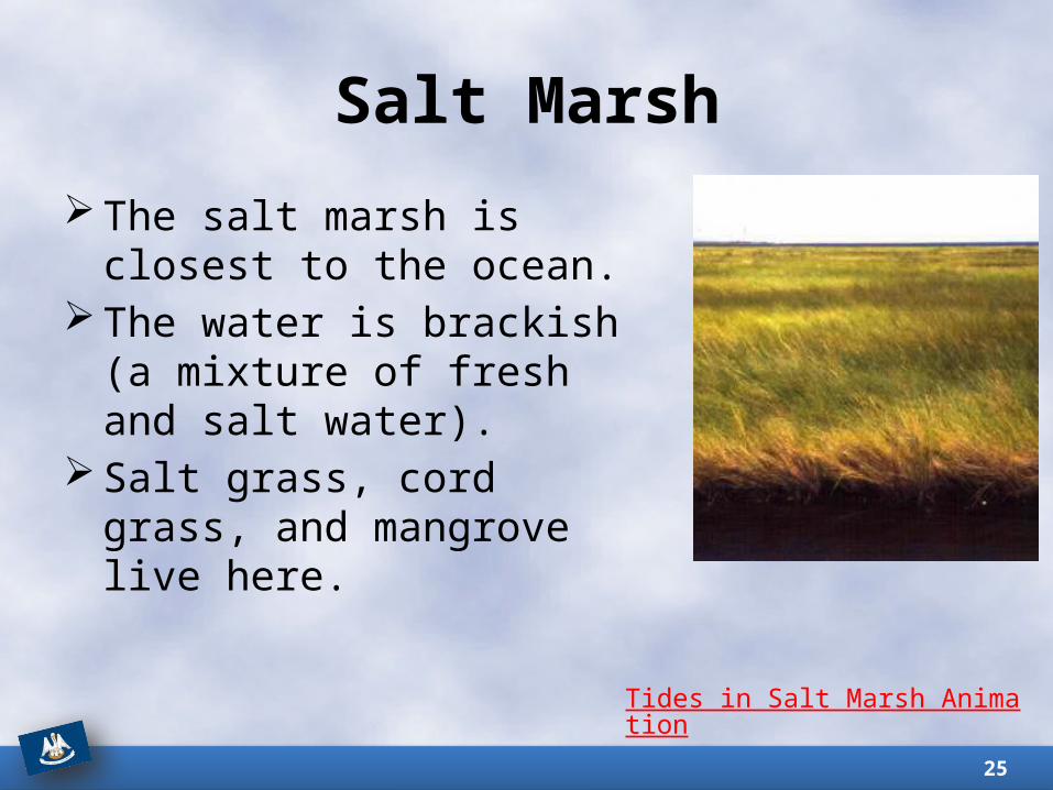
The salt marsh is closest to the ocean.
The water is brackish (a mixture of fresh and salt water).
Salt grass, cord grass, and mangrove live here.
Salt Marsh
Tides in Salt Marsh Animation

26
This area of marsh has freshwater from the river.
Plants here like iris and cattails cannot live in brackish water.
If saltwater enters a freshwater marsh, freshwater plants will die. This is called saltwater incursion.
Freshwater Marsh

27
Salt Domes Salt domes are found in the salt
marsh. They rise above the surrounding area in a dome shape.
Salt, sulfur, petroleum and other minerals may be found here.
The five largest domes are Avery Island, Weeks Island, Cote Blanche, Belle Isle, and Jefferson Island.

28
Hills Region This region is mostly in northern Louisiana, as
well as in a small area of the southeast. The land is rough and of higher altitude than the
rest of the state; the soil is reddish due to iron. Geologists (people who study the Earth) have
observed differences in the rock formations here. Uplifts, such as the Sabine Uplift and Dolet Hills,
are formed as rocks push against each other and are lifted. Ridges (wolds) are formed when these uplifts erode.
The Kisatchie Wold (NW Louisiana) has the state’s highest point, Driskill Mountain (535 feet).
Pine trees grow well here naturally and on pine tree farms.

29
Section 3: Waterways
Essential Question:• What role do waterways play in the lives
of people in Louisiana?

30
Section 3: Waterways What terms do I need to know?
• navigable• drainage basin• sediment• cutoff lake• raft lake• marsh lake• bayou

31
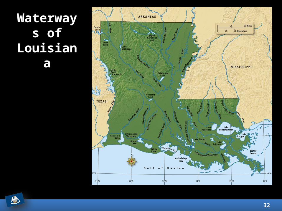
Introduction The dominant physical feature of
Louisiana is the nearly 5,000 miles of navigable waterways.
Waterways were a major part of the state’s history and are important today for trade and transportation.
The Mississippi River ends its journey through the U.S. in Louisiana at the Gulf of Mexico.
32
Waterways of
Louisiana

33
Rivers The Mississippi is the most important river in
Louisiana. The drainage basin (an area of land that
drains into tributaries and rivers) of the Mississippi is over 1.2 million mi² and extends to 31 states and two Canadian provinces.
The basin extends from New York to Montana and carries 375 million gallons of water daily through Louisiana.
Sediment (matter that settles to the bottom of liquid) from floods created rich farmlands.
Flood control systems now direct this sediment to the Gulf of Mexico.
34
Rivers (Continued) Red River: second largest river drainage
system in Louisiana; begins in New Mexico and flows into the Atchafalaya and Mississippi Rivers.
Ouachita River: begins in Arkansas; merges with the Tensas and Little Rivers to form the Black River.
Atchafalaya River: cleared in the 1830s for navigation; the Army Corps of Engineers controls the flow of Mississippi River water into the Atchafalaya.
Pearl River: runs from east-central Mississippi into Lake Borgne; the river splits into the East and West Pearl River branches surrounding Honey Island Swamp.

35
Rivers (Continued) Calcasieu River: flows from east of
Leesville to Lake Charles; a deepwater channel connects Lake Charles to the Gulf of Mexico.
The port at Lake Charles is successful because of its location near the Gulf Intracoastal Waterway.
Sabine River: part of the border with Texas; the Toledo Bend Reservoir was formed on the river by a dam to generate hydroelectric power.

36
Lakes Louisiana has several man-made lakes (e.g.
Toledo Bend, Lake D’Arbonne, Lake Claiborne, Sibley Lake, and Lake Chicot).
Pontchartrain is a large, shallow natural lake and is crossed by the 24-mile-long Causeway Bridge. The lake is a tidal lagoon with brackish water connected to the Gulf of Mexico.
Lake Maurepas is another lake and tidal lagoon with brackish water connected to Lake Pontchartrain.
Cutoff lakes, such as Cain River Lake and False River, are formed when a river changes course leaving behind water-filled bends.
37
Lakes (Continued) Raft lakes were created as a result
of rivers blocked by logjams which flooded nearby swamps (e.g. Caddo Lake and Lake Bistineau).
Marsh lakes were created behind low groups of ridges which retain water after floods (e.g. White Lake, Grand Lake, and Calcasieu Lake).

38
Bayous Bayous are waterways that are
associated with Louisiana; sometimes the state is called the Bayou State.
Some bayous are short and shallow, others long and navigable.
Hundreds of bayous spread across the state (e.g. Bayou Lafitte and Bayou Lafourche).

39
Section 4: Climate
Essential Question:• How has climate played a role in the
development of Louisiana?

40
Section 4: Climate
What terms do I need to know? • weather• climate• precipitation• tornado• hurricane• growing season
41
Weather measures the atmospheric conditions of a particular day.
Climate is the average weather of a place over a long period of time.
The climate of Louisiana is humid subtropical (summers are hot but there are winter freezes).
Louisiana has two climate regions: North Louisiana and South Louisiana.
Temperature, precipitation, and wind are the atmospheric conditions described by climate.
Introduction

42
North Louisiana has higher average temperatures than South Louisiana because the South is cooled by the Gulf of Mexico.
Record high: 114°F (1936) at Plain DealingRecord low: -16°F (1899) at MindenAverage July temperature: 73°F-93°FAverage January temperature: 32°F-55°F
Temperature

43
Precipitation is any form of water that falls from the atmosphere and reaches the ground.
Rain is the most common precipitation in the state.
Hail and sleet (frozen or partially frozen rain) are more common than snow.
Southwest Louisiana receives the most rainfall, while northwest Louisiana receives the least.
Precipitation

44
Tornadoes and hurricanes are two types of windstorms that affect the state’s people and property each year.
Wind
Tornado touchdown near Alexandria, LA (1981)
Hurricane Isaac targets Louisiana (2012)

45
Tornadoes are dark, funnel shaped clouds with swirling winds that can measure over 100 yards wide and move at 50 mph.
They form from the clouds of a thunderstorm when cool air meets warm.
They can develop quickly – sometimes in less than five or ten minutes.
Weather radar and other technology help to protect people from these violent storms.
Tornadoes
Northwest High School, St. Landry Parish, LA after 2002 tornado

46
A hurricane is a violent storm that forms in the Atlantic Ocean during the summer or fall with winds that extend hundreds of miles.
The storm rotates counterclockwise around the central “eye” with wind speeds from 74 to over 157 mph in the most powerful storms.
As a hurricane moves to the shore, high winds and high water cause a storm surge – walls of water 10 feet high or more.
Flooding and tornadoes are possible side effects of hurricanes.
Major hurricanes: Audrey (1957); Betsy (1965); Andrew (1992); Katrina & Rita (2005).
The 2005 hurricanes did over $150 billion in damage and killed over 1,400 people.
Hurricanes
Click for satellite image of Hurricane Katrina

47
Weather affects the state’s farm crops. Damage from Hurricane Katrina included:
• citrus trees killed by saltwater;• broken trees in forests and tree farms; • flooded rice fields and pastures.
A benefit of the state’s location is the long growing season (the number of days between the last killing frost (32°F) in spring and the first killing frost in fall). In the north it is 210 days while in the south it’s 290 days.
Strawberries, sugar cane, and cotton thrive in our state’s climate.
Climate and Agriculture

48
Section 5: People and the Environment
Essential Question:• How has human activity affected the
environment of our state?

49
Section 5: People and the Environment
What terms do I need to know?• wetlands• subsidence• nutria

50
Native Americans hunted animals for food, grew crops, and moved soil to build large mounds.
Henry Shreve (1830s) worked for years to clear the Red River Raft to make the river navigable for trade.
Much effort has gone in to trying to control the Mississippi River’s flooding and course.
Introduction

51
Spring floods are a part of the Mississippi River’s annual cycle.
Levees have been built to protect people and property from floods.
The flood of 1927 was a huge disaster which led the Army Corps of Engineers to add dams, canals, spillways and reservoirs to help control the river floods.
A negative consequence of controlling the floods is that silt is no longer deposited, which has led to gradual, but significant, land loss along the Gulf Coast.
Flood Control
Gibson, LA flood (1973)

52
Coastal erosion is a serious environmental issue in Louisiana.
The state has 40% of America’s wetlands, but it is losing wetlands to erosion at a high rate.
Wetlands are swamps, marshes, and other areas with a natural supply of water and are covered or soaked with water at least part of the year.
Fish, birds, and plants depend on the wetlands, and many people’s jobs depend on a healthy wetland environment.
Highway 1 is an example of a road threatened by coastal erosion.
Coastal Erosion

53
There are many causes of coastal erosion, that are both natural and man-made.
Subsidence is the slow sinking of land into the sea; worsened by lack of silt due to levees.
The slow rise of sea levels has made subsidence worse.
Storms, like hurricanes, can damage coastal areas.
The introduction of non-native plants and animals (e.g. nutria – large rodents brought to Louisiana in the 1930s) can damage vegetation.
Canal construction cuts through wetlands and can create saltwater incursion.
Causes of Coastal Erosion

54
The Coastal Wetlands Planning, Protection, and Restoration Act (CWPPRA) is a federal law designed to protect and rebuild wetlands.
The Deepwater Horizon disaster (2010) affected over 300 miles of Louisiana coastline.
Companies are now fined for damaging the coastal environment.
Local, state, and national leaders will need to work together to solve the problem of coastal erosion and land loss.
Crisis and Response

Return to Main Menu 55
Image Credits
Slide 1: Chris Miceli on Wikimedia Commons, Public Domain; Slide 2: Ken Thomas (alligator); Jillian.E (Chicot State Park); City of Monroe, LA; Albert Herring (Mardi Gras), Lael Butler (pelican); Jesper Rautell Balle (Cajun meal); Susan Adams (Chemin-a-Haut State Park) on Wikimedia Commons; Slide 16: U.S. Army Corps of Engineers; Slides 21 & 24: U.S. Geological Survey; Slide 22: U.S. Department of Agriculture; Slide 25: Louisiana Department of Wildlife and Fisheries; Slide 44: NOAA (tornado) and NASA (hurricane); Slide 45: FEMA; Slide 54: U.S. EPA; Image Credits Slide: Edd Prince on Wikimedia Commons; maps copyright Clairmont Press; all others public domain
Shown here: Fontainebleau State Park