© boardworks ltd 2005 1 of 33 these icons indicate that teacher’s notes or useful web addresses...
TRANSCRIPT

© Boardworks Ltd 20051 of 33
These icons indicate that teacher’s notes or useful web addresses are available in the Notes Page.
This icon indicates the slide contains activities created in Flash. These activities are not editable.
For more detailed instructions, see the Getting Started presentation.
1 of 33 © Boardworks Ltd 2005
Weather and Climate – an introduction

© Boardworks Ltd 20052 of 33
Why do geographers study the weather?
What is the difference between 'weather' and 'climate‘?
What is the water cycle?
What is precipitation?
Why does it rain?
Lea
rnin
g o
bje
ctiv
es

© Boardworks Ltd 20053 of 33
Why do geographers study the weather?
The weather has an impact on many of the things that we do! Can you explain how the weather affects these people?

© Boardworks Ltd 20054 of 33
Why do geographers study the weather?
What is the difference between 'weather' and 'climate'?
What is the water cycle?
What is precipitation?
Why does it rain?
Lea
rnin
g o
bje
ctiv
es

© Boardworks Ltd 20055 of 33
What is the difference between weather and climate?
Weather is the day to day changes in the atmosphere.
temperature precipitation
wind speed
wind direction cloud cover
humidity
air pressure sunshine

© Boardworks Ltd 20056 of 33
What is the difference between weather and climate?
Climate is the overall pattern of weather, usually based on an average over 30 years.
Click on the buttons to find out about these types of climate.

© Boardworks Ltd 20057 of 33
World climate zones
The types of climate can be classified into 6 major zones.

© Boardworks Ltd 20058 of 33
World climate zones
What climate zone do you live in?
What other climate zones have you visited?

© Boardworks Ltd 20059 of 33
Imagine that you are a tour operator. Decide which of these pieces of advice you would give to people depending on which climate zone they are planning to visit!
World climate zones

© Boardworks Ltd 200510 of 33
Climates across the world

© Boardworks Ltd 200511 of 33
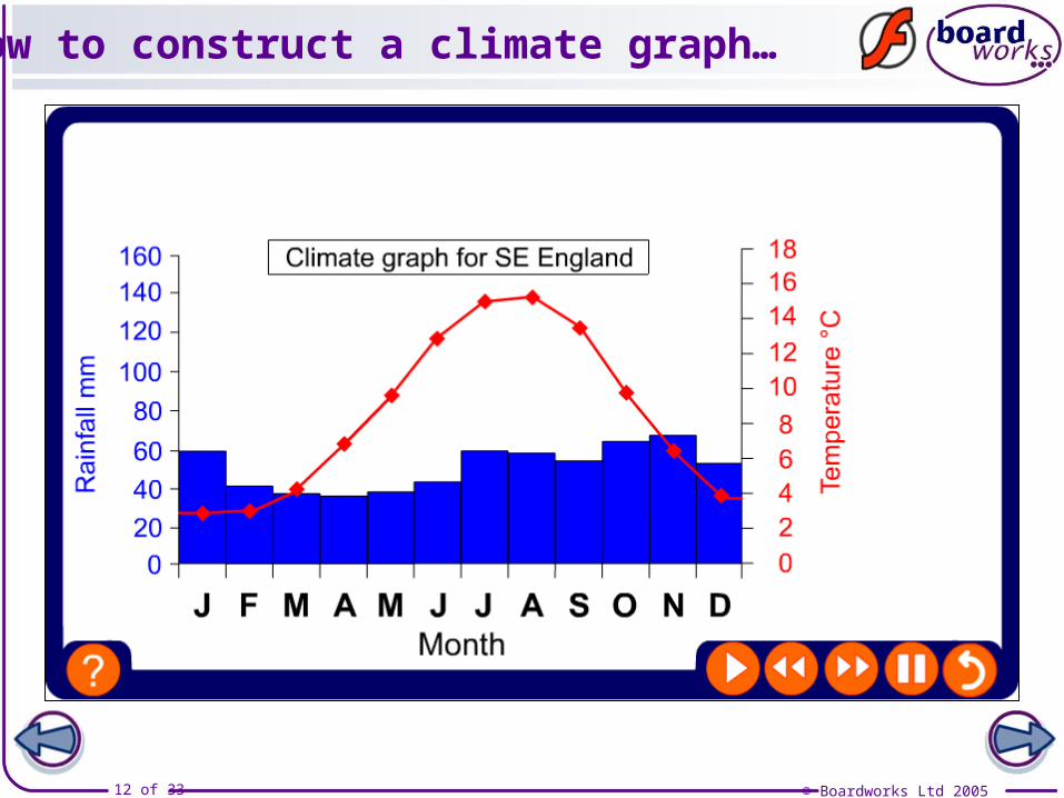
Climate graphs
Climate graphs are a way of showing how temperature and precipitation vary throughout the year for a particular place.
© Boardworks Ltd 200512 of 33
How to construct a climate graph…

© Boardworks Ltd 200513 of 33
2. Work out the right scale for each axis (look at your highest temperature and rainfall figures).
How to construct a climate graph…
1. Draw and label the axes (remember you need two names for the y axis – ‘temperature’ and ‘rainfall’ ).
3. Draw the graph using bars for rainfall and a line for temperature. Remember to plot the temperature points in the middle of the months on the x axis.

© Boardworks Ltd 200514 of 33
Plot your own climate graph!
Month Jan Fe Ma Apr Ma Jun Jul Aug Sep Oct Nov Dec
Rainfall (mm)
54 40 37 37 46 45 57 59 49 57 64 48
Temp
(0C)
4 5 7 9 12 16 18 17 15 11 8 5
London (Kew)
Use this data to draw a climate graph for London.
How does it compare to this climate graph of London?
Using data from an atlas draw a climate graph for another place, in the UK or somewhere else in the world.

© Boardworks Ltd 200515 of 33
UK - interactive climate graph

© Boardworks Ltd 200516 of 33
Why do geographers study the weather?
What is the difference between 'weather' and 'climate‘?
What is the water cycle?
What is precipitation?
Why does it rain?
Lea
rnin
g o
bje
ctiv
es

© Boardworks Ltd 200517 of 33
The water cycle
70% of the Earth’s surface is covered by water.
Store %Oceans and seas 97
Snow and ice (mainly in the Arctic and Antarctic) 2
In the atmosphere or on the land as rivers and lakes
1
Water is neither created nor destroyed. It is cycled round over and over again.
This recycling of water is called the water cycle.
Draw a graph to show where the Earth’s water is stored.

© Boardworks Ltd 200518 of 33
The water cycle

© Boardworks Ltd 200519 of 33
The water cycle

© Boardworks Ltd 200520 of 33
The water cycle in more detail

© Boardworks Ltd 200521 of 33
The water cycle – definitions!

© Boardworks Ltd 200522 of 33
Why do geographers study the weather?
What is the difference between 'weather' and 'climate‘?
What is the water cycle?
What is precipitation?
Why does it rain?
Lea
rnin
g o
bje
ctiv
es

© Boardworks Ltd 200523 of 33
What is precipitation?
Precipitation is water from the atmosphere. It can be in solid or liquid form.
Name as many different types of precipitation as you can!

© Boardworks Ltd 200524 of 33
Why do geographers study the weather?
What is the difference between 'weather' and 'climate‘?
What is the water cycle?
What is precipitation?
Why does it rain?
Lea
rnin
g o
bje
ctiv
es
© Boardworks Ltd 200525 of 33
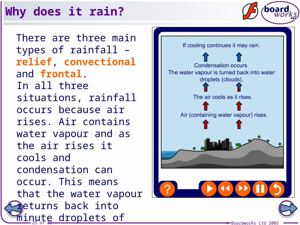
Why does it rain?
There are three main types of rainfall – relief, convectional and frontal.
In all three situations, rainfall occurs because air rises. Air contains water vapour and as the air rises it cools and condensation can occur. This means that the water vapour returns back into minute droplets of water and falls as rain!

© Boardworks Ltd 200526 of 33
Convectional rain

© Boardworks Ltd 200527 of 33
Convectional rain

© Boardworks Ltd 200528 of 33
Relief rain

© Boardworks Ltd 200529 of 33
Relief rain

© Boardworks Ltd 200530 of 33
Frontal rain

© Boardworks Ltd 200531 of 33
Forecasts/climatic data
www.worldclimate.comwww.worldweather.orghttp://www.met-office.gov.uk/
Internet links
Hurricane Andrew 1992

© Boardworks Ltd 200532 of 33
Weather and Climate Bingo!

© Boardworks Ltd 200533 of 33
Key Ideas
Geographers study the weather because it has an impact on people’s daily lives and the activities that they do.Weather is the day to day changes in the atmosphere.Climate is the overall pattern of weather, usually based on an average over 30 years.The British Isles has a temperate climate. This means that it is not too hot, not too cold, not too dry and not too wet!Water is neither created nor destroyed. It is cycled round over and over again. This recycling of water is called the water cycle.Precipitation is water from the atmosphere. It can be in solid or liquid form. There are three main types of rainfall – relief, convectional and frontal. In all three situations, rainfall occurs because air is forced to rise.