egenda.dumgal.gov.ukegenda.dumgal.gov.uk/aksdumgal/images/att20926.pdf · change to settlement...
TRANSCRIPT
---------
12 SEPTEMBER 2006 COMMlTTEE REPORT PLANNING 8, ENVlRONMENT COMMlTTEE
. .
40.00
House under co
4
Privo l e driveway to serve 3 no. houses Inspection Chamber
. . . . . . .
design of houses and porosity test result.
li PROPOSED SITE PLAN
A
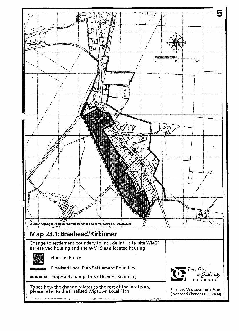
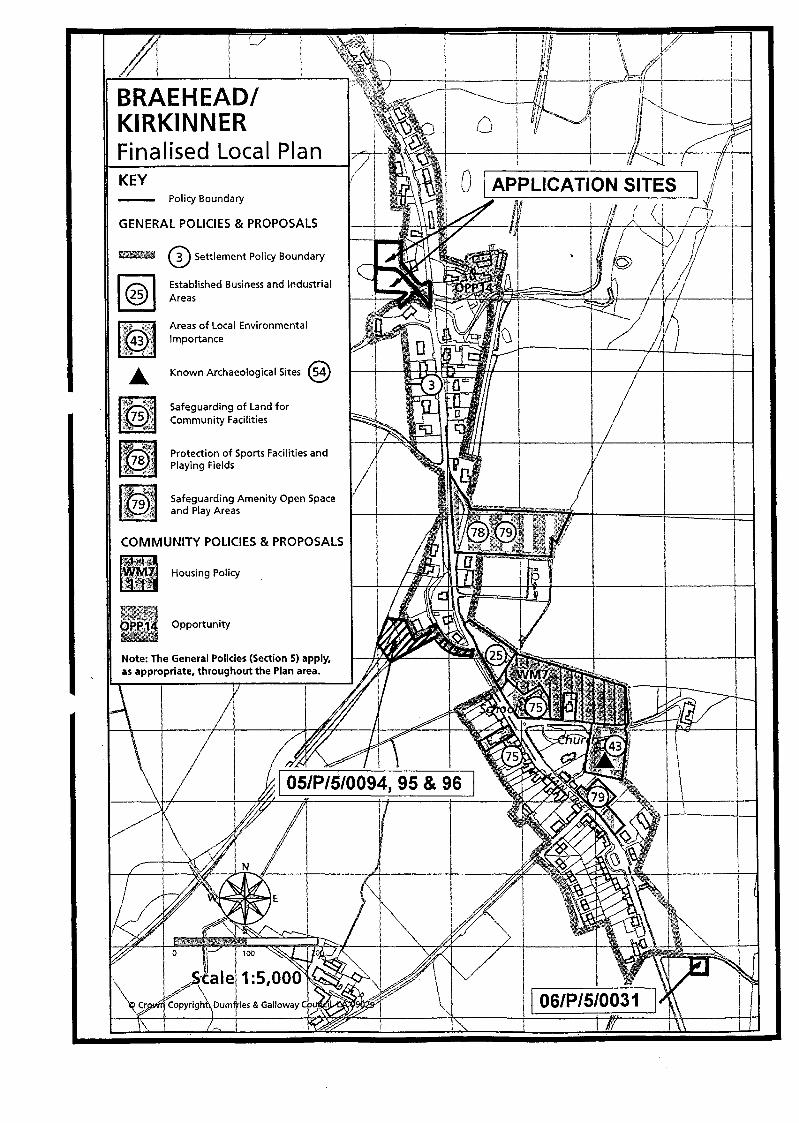
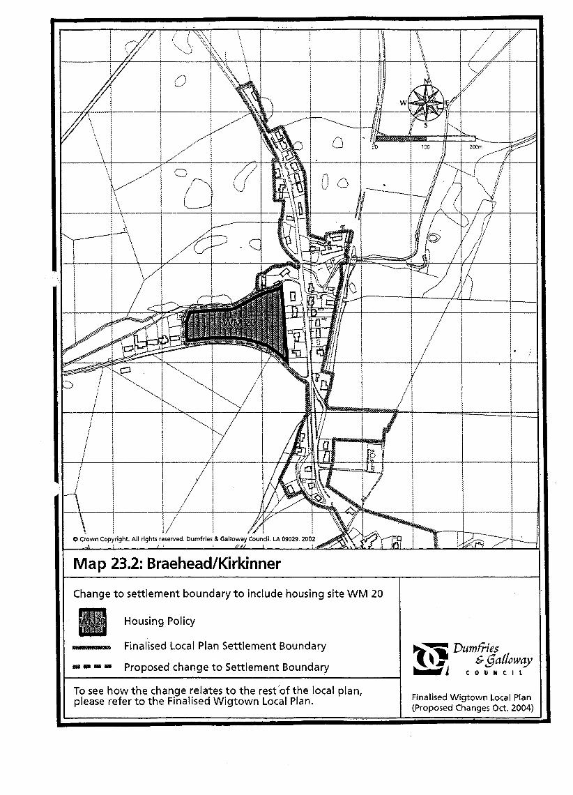
~ Map 23.1: Braehead/Kirkinner I Change to settlement boundary to include infill site, site WM21 as reserved housing and site WM19 as allocated housing
Housing Policy
Pumfris Finalised Local Plan Settlement Boundary
= Proposed change to Settlement Boundary
I Finalised Wigtown Local Plan (Proposed Changes Oct. 2004)
To see how the change relates to the rest,of the local plan, please refer to the Finalised Wigtown Local Plan.
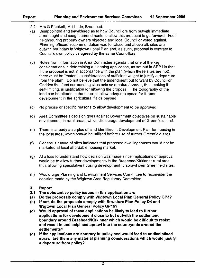
Map 23.2: Braehead/Kirkinner
Change to settlement boundary t o include housing site WM 20
Housing Policy
Finalised Local Plan Settlement Boundary - Dumfries s g a ~ o w y
= a Proposed change to Settlement Boundary -1 C O U N C I L
Finalised Wigtown Local Plan (Proposed Changes Oct. 2004:
To see how the change relates to the rest bf the local plan, please refer t o the Finalised Wigtown Local Plan.
I

5 Report Planning and Environment Services Committee 12 September 2006
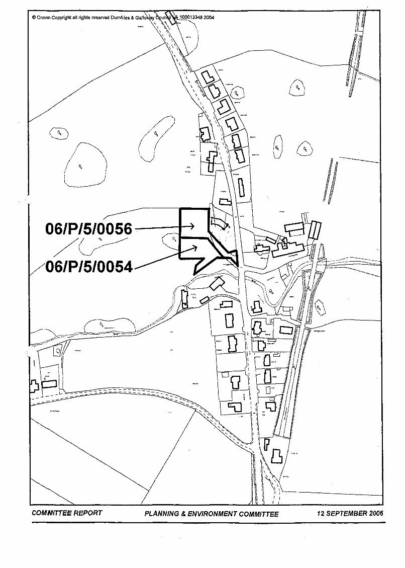
06/P/5/0054 and 06/P/5/0056 - APPLICATIONS FOR - (A) - OUTLINE PLANNING PERMISSION FOR THE ERECTION OF ONE DWELLINGHOUSE; INSTALLATION OF SEPTIC TANK; AND
PLANNING PERMISSION FOR ERECTION OF ONE DWELLINGHOUSE; INSTALLATION OF SEPTIC TANK AND COMMUNAL SOAKAWAY SYSTEM (06/P/5/0054) AT PLOTS A AND B, MILDRIGGAN BRIDGE, KIRKINNER (RESPECTIVELY)
FORMATION OF ACCESS (06/P/5/0056): AND (B) - OUTLINE
RECOMMENDATION - Refuse on the following grounds: 1. The proposed development sites do not form an integral part of the village and lie outwith the Settlement Boundary as defined in the Wigtown Local Plan. As such, the proposals are contrary to Council policy as contained in Dumfries and Galloway Structure Plan Policy 04 and Wigtown Local Plan General Policies GP3 and GP15; and
2. Approval of these applications would be likely to lead to further applications for development close to but outwith the Settlement Boundary at other locations around BraeheadlKirkinner, which would be difficult to resist and would result in undisciplined sprawl into the countryside around the settlement, which is a form of development fundamentally contrary to sound planning principles; to Council Structure Plan Strategy Statement 2; to the rational and cost-effective delivery of services; and to Government advice as contained in SPP3 “Planning for Housing”.
Note: Since this application was considered by the Wigtown Area Committee, the Wigtown Local Plan has been adopted. The reason for refusal has therefore been amended to reflect this fact by the removal of reference to the now superseded Whithorn and the Machars Local Plan.
1. At the meeting of the Wigtown Area Regulatory Committee on 12 July 2006, Members resolved (by a vote of 6 to 3 - 9 members present) to recommend to the Planning & Environment Committee that these applications be approved, as an exception to policy, on the grounds that the Settlement Boundary should be rationalised to round-off the built up area with a self limiting extension and that any detailed application(s) relating to these sites should be submitted to a future meeting for consideration by the Area Committee. The report considered by the Area Committee is attached as Appendix 1.
Recommendation of Area Regulatory Committee
2. Rep resen ta tions 2.1 additional representation was received.
Following consideration of the proposal by the Area Committee the following
Report Planning and Environment Services Committee 12 September 2006
2.2 Mrs G Plunkett, Mill Lade, Braehead: (a) Disappointed and bewildered as to how Councillors from outwith immediate
area fought and sought amendments to allow this proposal to go forward. Four neighbouring property owners objected and local Councillor voted against. Planning officers’ recommendation was to refuse and above all, sites are outwith boundary in Wigtown Local Plan and, as such, proposal is contrary to Council’s own policy as agreed by the same Councillors.
(b) Notes from information in Area Committee agenda that one of the key considerations in determining a planning application, as set out in SPPl is that if the proposal is not in accordance with the plan (which these sites are not), there must be “material considerations of sufficient weight to justify a departure from the plan”. Do not believe that the amendment put forward by Councillor Geddes that land surrounding sites acts as a natural border, thus making it self-limiting, is justification for allowing the proposal. The topography of the land can be altered in the future to allow adequate space for further development in the agricultural fields beyond.
(c) No precise or specific reasons to allow development to be approved.
(d) Area Committee’s decision goes against Government objectives on sustainable development in rural areas, which discourage development of Greenfield land.
(e) There is already a surplus of land identified in Development Plan for housing in the local area, which should be utilised before use of further Greenfield sites.
(9 Generous nature of sites indicates that proposed dwellinghouses would not be marketed at local affordable housing market.
(9) At a loss to understand how decision was made since implications of approval would be to allow further developments in the Braehead/Kirkinner rural area thus allowing speculative housing development to sprawl over Greenfield sites.
(h) Would urge Planning and Environment Services Committee to reconsider the decision made by the Wigtown Area Regulatory Committee.
3. Report 3.1 The substantive policy issues in this application are: (a) Do the proposals comply with Wigtown Local Plan General Policy GP3? (b) If not, do the proposals comply with Structure Plan Policy D4 and
Wigtown Local Plan General Policy GP15? (c) Would approval of these applications be likely to lead to further
applications for development close to but outwith the settlement boundary around BraeheadlKirkinner which would be difficult to resist and result in undisciplined sprawl into the countryside around the settlements? If the applications are contrary to policy and would lead to undisciplined sprawl are there any material planning considerations which would just@ a departure from policy?
(d)
2

5 Report Planning and Environment Services Committee 12 September 2006
3.2 Adopted Wigtown Local Plan Policy GP3 require proposals for new residential development outwith settlements to be assessed in terms of housing in the countryside policies contained in the Structure and Local Plan. The Settlement Boundary of Braehead at this location as defined in the Local Plan Inset Map, follows the line of the burn to the south of the sites and a long-established field boundary in the form of a hedge and fence running (generally) north-south and following the line of the western boundary of existing houses in the village. With the exception of the joint access road, which runs down the eastern side of the hedge/fence and is included in the application for Plot A, the developable areas of both application sites lie immediately to the west of the field boundary and therefore outwith the settlement. Consequently, the applications are contrary to GP3 and must be considered under housing in the countryside policies.
3.3 Under Structure Plan Policy D4 and Finalised Local Plan GP15, proposals for residential development in the countryside must meet one or more of five requirements. None of the five criteria apply in this case. The proposals are therefore clearly contrary to the Development Plan and no reasoned justification was presented as part of the original submission as to why a departure from policy should be accepted in this case. The only justification presented by the applicant’s agent in his verbal presentation to the Area Committee is that an adjustment of the line of the Settlement Boundary, by extrapolating from the existing line to the north, adjacent to Holly Cottage and Millburn to a point adjacent to Lassdale House to the south west, thus including the application sites, is a “logical” extension of the settlement and that development of two houses at this location would be “self- limiting’’ because of the topography of the site and the limitation in numbers of dwellings that could be accessed from a private road.
3.4 settlement. Where no such need exists, the more compelling logic is to define the Settlement Boundary by existing strong physical features such as the burn and fence/hedge field boundary, as has been done in this case. This approach is reinforced by the fact that there is already a very substantial over-supply of housing land identified in Braehead/Kirkinner (see below) and that there are practical difficulties in developing the two application sites by virtue of the fact that soakaway systems for other nearby dwellings are present. It must also be noted that no objection to the line of the Settlement Boundary at this point was received during the Local Plan process, and the Area Committee itself approved the Settlement Boundary and the inclusion of other areas of additional housing land when considering final alterations to the Finalised Wigtown Local Plan on 21 April 2004, and this decision was subsequently ratified by the Planning and Environment Services Committee on 8 July 2004. Members of the public. e.g. the local residents who have objected to this application, are entitled to expect that the Council will determine applications in accordance with the newly adopted Local Plan.
However such logic only applies if there is a need to include further land in the
3.5 In considering this application, the Area Committee accepted the view put forward by the applicant’s agent that the realignment of the boundary to include the sites was ‘logical’ and that the development was ‘self-limiting’ in terms of numbers of houses that could be accessed from a private road. On the latter point, it has to be noted that officers’ road safety advice is not always followed, and there can be no guarantee that an excessive number of accesses will not be approved in future. Accordingly, the ‘self-limiting’ argument can be given little weight. In terms of the topography of the sites, there is no clear demarcation or other physical feature
Report Planning and Environment Services Committee 12 September 2006
between them and the agricultural land further to the west. Consequently, the topography of the sites cannot, in itself, be taken as a limiting factor restricting further development. At best, the topography is a mitigating factor, but it does not amount to a positive reason to override the statutory Development Plan.
3.6 As already indicated above, the recently adopted Local Plan already incorporates additions to housing allocations at BraeheadIKirkinner as proposed by the Area Committee. Reference to the Wigtown Local Plan Housing Audit (February 2006) shows a potential housing supply in Braehead/Kirkinner, including the opportunity site and reserved housing land, of 99 units. For the period 1998 to 2004, the Audit identifies 7 new build completions. Additional completions from 2004 until the present total 718. Setting the total of 15 completions in the last 8 years against the indicative supplv figure of 99 units, therefore, it is self-evident that these numbers already represent a very large existing over-supplv of housing land in Braehead/Kirkinner. Consequently, there is demonstrablv no need for anv further sites to be identified.
3.7 All developments outwith Local Plan Settlement Boundaries fall to be considered under the policies relating to development in the countryside. Approval of these applications would therefore be likely to lead to further applications for development close to but outwith Settlement Boundaries at other locations around Braehead/Kirkinner and elsewhere, and make them difficult to resist. Incremental developments of this nature outwith defined and constantly re-defined Settlement Boundaries would create undisciplined sprawl into the countryside around settlements and have the potential to create a “doughnut” effect, whereby the settlement expands outwards into greenfield sites, while identified housing and suitable infill sites within the settlement remain undeveloped. This form of development is fundamentally contrary to sound planning principles, the rational and cost-effective delivery of services, and Government advice as contained in SPP3 “Planning for Housing”. It should also be noted that approval of further sites around the settlement is potentiallv pre-iudicial to landowners and developers who have properly engaged in the Local Plan process to have their sites identified for housinq and act as a disincentive to investment in the necessarv infrastructure to make these sites effective. Such approvals are also counter-productive in terms of regeneration of the core areas of established towns and villages and conflict with the fundamental aims of the Structure Plan, with particular regard to Strategy Statement 2, which clearly encourages development “in towns and villages”.
3.8 If the only criteria to be applied for approval of housing sites as departures from policy are that they are adjacent to but outwith a Settlement Boundary, or that there is an indentation in the line of the boundary at a particular location which could be adjusted to include the sites, then the whole Development Plan policy framework on housing in the countryside under Structure Plan D4 and Wigtown Local Plan GP3 and GP15 and other relevant policies and Structure Plan strategies encouraging development wifhin settlements is seriously undermined. This is a matter of particular concern given that the Wigtown Local Plan has only just been formally adopted (31 July 2006) and now forms an integral part of the Council’s statutory Development Plan.

5 Report Planning and Environment Services Committee 12 September 2006
4. Members are asked to refuse on the grounds that:
I. the proposed development sites do not form an integral part of the village and lie outwith the Settlement Boundary as defined in the Wigtown Local Plan. As such, the proposals are contrary to Council policy as contained in Dumfries and Galloway Structure Plan Policy D4; and Wigtown Local Plan General Policies GP3 and GP15; and
2. approval of these applications would be likely to lead to further applications for development close to but outwith the Settlement Boundary at other locations around BraeheadlKirkinner, which would be difficult to resist and would result in undisciplined sprawl into the countryside around the settlement, which is a form of development fundamentally contrary to sound planning principles; to Council Structure Plan Strategy Statement 2; to the rational and cost-effective delivery of services; and to Government advice as contained in SPP3 “Plan n i n g for Housing ” .
Re com men da tio n
David W Bell - Report Author Operations Manager Development Control Environment Tel: 01 387 2601 76
Date of Report: 29 August 2006
File Ref: dwbra21cr DGI 2HR
Hillard Anderson Group Manager Development and
Planning and Environment Kirkbank House English Street DUMFRIES
APPENDICES - I
APPENDIX 7
David Bell - Operations Manager Development Control Kirkbank, English Street, Dumfries, DGI 2HS Telephone (01387) 260199 - Direct Dial Fax (01387) 260188
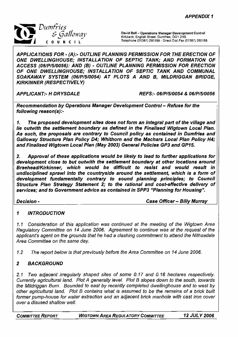
APPLICATIONS FOR - (A):- OUTLINE PLANNING PERMISSION FOR THE ERECTION OF
ACCESS (06/P/5/0056): AND (B) - OUTLINE PLANNING PERMISSION FOR ERECTION ONE DWELLINGHOUSE; INSTALLATION OF SEPTIC TANK; AND FORMATION OF
OF ONE DWELLINGHOUSE; INSTALLATION OF SEPTIC TANK AND COMMUNAL SOAKAWAY SYSTEM (06/P/5/0054) AT PLOTS A AND B, MlLDRlGGAN BRIDGE, KIRKINNER (RESPECTIVELY)
APPLICANT:- H DRYSDALE REFS:- 06/P/5/0054 & 06/P/5/0056
Recommendation by Operations Manager Development Control - Refuse for the following reason(s):-
7. The proposed deveiopment sites does not form an integral part of the village and lie outwith the settlement boundary as defined in the Finalised Wigtown Local Plan. As such, the proposals are contrary to Council policy as contained in Dumfries and Galloway Structure Plan Policy 04; Whithorn and the Machars Local Plan Policy H4; and Finalised Wigtown Local Plan (May 2003) General Policies GP3 and GP75.
2. Approval of these applications would be likely to lead to further applications for development close to but outwith the settlement boundary at other locations around Braehead/Kirkinner, which would be difficult to resist and would result in undisciplined sprawl into the countryside around the settlement, which is a form of development fundamentally contrary to sound planning principles; to Council Structure Plan Strategy Statement 2; to the rational and cost-effective delivery of services; and to Government advice as contained in SPP3 “Planning for Housing”.
Decision - Case Officer - Billy Murray
7 INTRODUCTION
1.1 Consideration of this application was continued at the meeting of the Wigtown Area Regulatory Committee on 14 June 2006. Agreement to continue was at the request of the applicant’s agent on the grounds that he had a clashing commitment to attend the Nithsadale Area Committee on the same day.
1.2 The report below is that previously before the Area Committee on 14 June 2006.
2 BACKGROUND
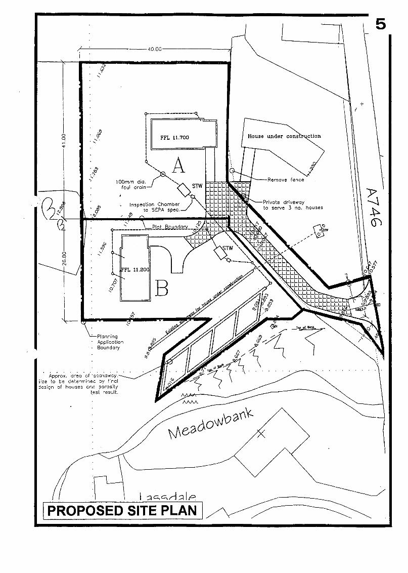
2. I Two adjacent irregularly shaped sites of some 0.17 and 0.16 hectares respectively. Currently agricultural land. Plot A generally level. Plot B slopes down to the south, towards the Mildriggan Burn. Bounded to east by recently completed dwellinghouse and to west by other agricultural land. Plot B contains what is assumed to be the remains of a brick built former pump-house for water extraction and an adjacent brick manhole with cast iron cover over a disused shallow well.
COMMITTEE REPORT WIGTOWN AREA REGULATORY COMMITTEE 72 JULY 2006
5
2.2 With the exception of the proposed joint access road, which is shown as being part of Plot A, the sites lie outwith and to the west of, the settlement boundary of Kirkinner as defined in the finalised Wigtown Local Plan. The settlement boundary at this point follows the Mildriggan Burn (to the south) and the existing field boundary (fence/hedge), which coincides with the eastern boundary of the application sites. Southern part of Plot B lies within an area identified as low/medium flood risk. The area surrounding Braehead/Kirkinner, within which the sites are located, has been identified in the Finalised Wigtown Local Plan as suffering long-term depopulation.
2.3 Planning permission for the erection of a dwellinghouse at Mill Lade, Kirkinner, on a site immediately to the east of the application sites, which is within the settlement and was the site of a former agricultural or storage building, was granted in May 2004 (04/P/5/0051). House on this site is now virtually complete, with the exception of some external worksh’andscaping, and is occupied.
2.4 Applications are in outline and seek to establish the principle of two dwellinghouses at this location.
2.5 Proposed vehicular access to the sites from the A746 is by means of a shared private access to serve the two proposed dwellinghouses and the existing recently completed house at Mill Lade.
2.6 Proposed foul drainage is by an individual septic tank on each site with outfall to a joint soakaway system located in the southern part of Plot B adjacent to the Mildriggan Burn. Connection to mains water is available.
2.7 Submission includes indicative layouts showing house positions, location of septic tanks and soakaway and road layout.
3 CONSULTATIONS
3.1 Principal Road Services Officer, Wigtown:-
(a) house. Consequently, there will be three houses served by this junction.
Proposed dwellinghouses to take access onto A746 via access for recently completed
(b) Appropriate visibility would be 2.4 x 70 metres in both directions. This visibility is available to the north with 2.4 x 50 available to the south. This degree shortfall at this location, which is within a 30 mph speed restriction zone and where traffic control measures at the narrow bridge to the south tend to restrict approach speeds, is acceptable.
(c) Parking and turning for two cars should be provided within each site.
First five metres of access from public road should be surfaced to Council standard.
(d) No objection, subject to imposition of conditions as recommended.
3.2 Scottish Water:-
(a) No objection.
COMMITTEE REPORT WIGTOWN AREA REGULATORY COMMITTEE 12 JULY 2006

3.3 Scottish Environment Protection Agency
(a) Confirm septic tanks and soakaway appropriate method of sewage disposal at these sites and submitted percolation test results satisfactory. Advice subject to following conditions:
Septic tanks are of appropriate capacity to meet requirements of BS 6297:1983 Soakaway is constructed to accord with BS 6297:1983 and test results. No part of the soakaway is located within I O metres of a drain or watercourse or within 50 metres of a spring, well or borehole.
From submitted plans it is clear that burn runs close to Plot B. Under the Water Env,, onment (Controlled Activities) (Scotland) Regulations 2005, Scottish Environment Protection Agency will not look favourably on any “hard-bank engineering or works that encroach onto the floodplain increasing flood risk downstream. Whilst do not perceive application sites to have any such effect, SEPA must be consulted on any flood protection that may be proposed in the future.
4 REPRESENTATIONS
4.1 G Plunkett, Mill Lade, Braehead:-
(a) Has a number of concerns with applications. Main area of concern is access road, which would be shared with (my) property if approved. Do not think that road in present state could cope with extra traffic. Entrance to main road is limited and should be investigated by Roads Department. Also requests confirmation that upgrade and maintenance of road would fall to Council as understands that if road serves three houses or more in must be “adopted”.
(b) Understands that sites lie outwith Development Plan for KirkinnedBraehead, that there is already a surplus of land identified for housing and that applications are therefore contrary to Development Plan already in place.
(c) Boundaries on proposed plans differ from (my) title plan (copy provided). Also note that plans show part of mutual boundary fence to be removed and would seek clarification on this point.
4.2 D Cole, Holly Cottage, Braehead:-
(a) Objects to proposal to build two houses at this location, which is in the centre of Braehead and therefore like building on village green. Has found that village well is on site, which therefore confirms that site is in fact the village green.
(b) Whole of north side of house on Plot A would be parallel to Holly Cottage where lightesthvarmesf room is located. If anything were ever built there (on Plot A) it should be at an angle so that not looking directly into (my) house.
(c) Already three vehicles at new bungalow exiting onto single lane 'hive way to oncoming traffic” bridge. Questions how many more vehicles will be coming out there if two more houses approved. Therefore considers proposals constitute a “traffic hazard. COMMITTEE REPORT WIGTOWN AREA REGULATORY COMMITTEE 72 JULY 2006
5
(d) This may now be a “development area” but main road here is horrendous and getting worse with speeds of 60 mph not unusual. More building will generate more traffic and asks if Kirkinner to have a bypass.
(e) Soakaways for these tanks runs through middle of plots.
Proposal may make access to septic tanks for Holly and Miller‘s cottages impossible.
Representor also raises other issues in relation to design/finishes of recently completed house, views enjoyed from applicant’s own house and noise during construction phase of recent and proposed developments. These matters are not material to the consideration of this outline planning application.
4.3 D & P J Woods, Millburn, Braehead:-
(a) Waste disposal from (OUT) house is by septic tank with soakaway in field to rear of property. If proposal goes ahead it could well interfere with proper drainage, resulting in blockage and backup of waste water. At least three other properties also have soakaways in same field and it is unlikely that ground would be able to cope with extra waste created by a further two houses.
(b) Proposed development is located away from road and behind existing properties on what must surely be an inappropriate site as it does not even ‘)dug a gap”.
(c) Sites are currently in use as farmland and there appears to be no justification for change of use to residential. If this development proceeds it will only be a matter of time before whole field is given over to a housing estate and is extremely doubtful if sufficient resources are available to provide necessary services.
(d) Whilst property does not adjoin application sites, it is only some “fifty feet” from it and no notice of application was received. Site notices advising of applications were fixed to a telegraph pole at site access from public road. To view these involved walking along busy road with no footpath, restricted visibility for both drivers and pedestrians and where 30 mph speed limit is routinely ignored. (Note: There being intetvening land between the sites and the property at Millburn there is no statutory requirement for notification. Site notices advertising proposals potentially contrary to the development plan are displayed by the planning authority at a prominent location close to the site so as to be visibly to the wider public. All applications are listed in the local press. Therefore confirmed that proper neighbour notification and advertisement procedures were undertaken by both the applicant and the planning authority).
(e) of two further new houses can be justified.
Several properties currently for sale in vicinity and therefore difficult to see how building
(0 Structure Plan Policy 0 4 and should therefore be rejected.
As stated on site notice, development is contrary to the development plan under
5 REPORT
COMMITTEE REPORT WIGTOWN AREA REGULATORY COMMITTEE 12 JULY 2006
5. I The application falls to be considered in terms of Dumfries and Galloway Structure Plan Policy 0 4 (Housing in the Countryside) and S3 (Development in Flood Risk Areas); and Whithorn and the Machars Local Plan Policy H4 (Restriction on Houses in the Countryside).
General Policies contained in the Finalised Wigtown Local Plan, which is the latest statement of Council policy and is moving towards adoption in mid-2006, are also a material consideration carrying significant weight. Consequently the application must also be assessed against Local Plan Policies; GPI (Development Principle); GP2 (Development Considerations); GP3 (Settlement Boundaries); GP15 (Housing in the Countryside); GP58 (Flood Risk and Development); and GP60 (Water Sewerage and Drainage Provision).
Government policy and advice contained in SPP3 (Planning for Housing); SPPl5 (Rural Development); and PA N72 (Housing in the Countryside) is a further material consideration.
The stated Policies and advice are set out in Appendix A to this report.
5.2 Section 25 of the Town and Country Planning (Scotland) Act 1997 requires planning authorities, when making a determination under the Planning Acts, to have regard to the Development Plan and to make the determination in accordance with the Plan unless other material considerations indicate otherwise.
5.3 Whithorn and the Machars Local Plan Policy H4 and Finalised Wigtown Local Plan GP3 require proposals for new residential development outwith settlements to be assessed in terms of housing in the countryside policies contained in the Structure and Local Plan.
5.4 The western settlement boundary of Braehead/Kirkinner at this point, as defined in the Finalised Wigtown Local Plan, comprises the Mildriggan Burn and the existing fence/hedge which is the mutual boundary between the field containing the application sites and the site of the new house at Mill Lade. With the exception of the short length of proposed shared private access road (approximately 45 metres), the application sites are located immediately to the north of the burn and west of the field/Mill Lade site boundary and therefore outwith the settlement. The access road is to the east of the field boundary and therefore within the settlement. Consequently, the principle of the proposals must be assessed against policies for housing in the countryside.
5.5 All of the relevant policies only permit the erection of new houses in the countryside in special circumstances identified in the development plan. In particular, under Structure Plan 0 4 proposals for individual houses in the countryside must meet one or more of five stated requirements.
5.6 In this case the proposals do not meet any of the five requirements in that:
( I ) building.
It is not the change of use and alteration of a traditionally built agricultural or other
(2) curtilage. (3) Plan.
It is not the replacement of a habitable dwellinghouse by a new house within the same
The site does not form part of an existing small building group identified in the Local
COMMITTEE REPORT WIGTOWN AREA REGULATORY COMMITTEE 12 JULY 2006
(4) Whilst the sites are within an area identified in a Local Plan as suffering long term depopulation there is no evidence of a previous dwellinghouse on the site (as would be required to justify an approval under Local Plan WM13).
(5) No justification has been provided to show that the house is essential at the proposed location for the needs of agriculture or other uses requiring an appropriate rural location in the countryside.
The proposal is therefore contrary to the development plan as defined by Structure Plan 0 4 and Whihorn and the Machars Local Plan H4.
5.7 Given the above advice, the determining issue is whether there are any other material considerations sufficient to justify a departure from the Development Plan.
5.8 When considering a recent application for planning permission for a dwellinghouse on a site immediately outside the southern settlement boundary of Kirkinner, where policy advice was the same as that above, the Area Committee took the view that the development was acceptable on the grounds that if was neither building in the countryside nor sporadic residential development but was “development on the periphery of the village” (06/P/50031). (Note: This application has therefore been referred to the Planning and Environment Services Committee for determination and will be considered on 13 June 2006). That being the case and if the only criterion to be applied is that application sites are immediately outwith a settlement boundary then the Committee may also be minded to approve these applications.
5.9 The Structure Plan does not recognise such a distinction as “development on the periphery of a settlement”. All developments outwith Local Plan Settlement Boundaries fall to be considered under the policies relating to development in the countryside. Approval of these applications would therefore be likely to lead to further applications for development close to but outwith settlement boundaries at other locations around Braehead/Kirkinner and elsewhere, and make them difficult to resist. Incremental developments of this nature outwith defined and constantly re-defined settlement boundaries would create undisciplined sprawl into the countryside around settlements and have the potential to create a “doughnut” effect, whereby the settlement expands outwards into greenfield sites and identified housing and suitable infill sites within the settlement remain undeveloped. This form of development is fundamentally contrary to sound planning principles, the rational and cost-effective delivery of services, and Government advice as contained in SPP3 “Planning for Housing”.
5. IO In terms of existing housing land supply in Braehead and Kirkinner, it should be noted that, on 8 July 2004, the Planning and Environment Services Committee approved final alterations to the Finalised Wigtown Local Plan, which had previously been agreed by the Wigtown Area Regulatory Committee on 21 April 2004. In addition to existing housing land allocation at WM7 and OPP14, these alterations added further housing sites at WMl9, WM20 and reserved housing land at WM21. Reference to the Wigtown Local Plan Housing Audit (February 2006) shows a potential housing supply in Braehead/Kirkinner, including the opportunity site and reserved housing land, of 99 units. For the period 1998 to 2004, the Audit identifies 7 new build completions. It is self-evident, therefore that these numbers already represent a very large existing over-supply of housing land in Braehead/Kirkinner, with no need for any further sites to be identified. In addition to these allocated sites, there are three sites at the former station yard which already have the benefit of detailed planning
COMMITTEE REPORT WIGTOWN AREA REGULATORY COMMITTEE 12 JULY 2006
permission. Consequently, if the only criterion to be applied in the consideration of proposals for individual residential developments is whether the land is adjacent to a settlement, then the whole policy framework, in particular Whithorn and the Machars H4 and Finalised Local Plan GP3, is undermined. This is a particularly serious position, given that the Council‘s intention to adopt the Wigtown Local Plan has now been advertised and adoption is programmed for 3 1 July 2006.
5.11 It should also be noted that approval of further such sites around the settlement would be prejudicial to landowners and developers who have properly engaged in the Local Plan process to have their sites identified for housing, and would be likely to act as a disincentive to investment in the necessary infrastructure to make these sites effective. Such approvals are also counter productive in terms of regeneration of the core areas of established towns and villages and conflict with the fundamental aims of the Structure Plan, with particular regard to Strategy Statement 2, which clearly encourages development “in towns and villages”.
5.12 Drawing together all of the above, therefore, advice to committee is that the location of the sites immediately outwith the defined settlement boundary does not represent a material consideration sufficient to justify a departure from policy.
(Note: Subject to updating and minor amendment to tailor them to these particular applications, the comments contained in Paragraphs 4.9 to 4.12 (above) reflect the advice given to the Planning and Environment Services Committee in the report on the application for the erection of a single dwellinghouse outwith the southern boundary of Kirkinner (06/P/5/0031), which is to be considered on 13 June 2006)
5.13 Subject to the advice of the Principal Road Services Officer, the proposal raises no policy issues in terms of traffic generation and road safety. With regard to the question of adoption of the access road raised by one of the representors, the Principal Road Services Officer would normally accept a private access arrangement for up to three houses but would require a road to adoptable standard for numbers in excess of three. Consequently, an adoptable road would not be required in this case.
5.14 All existing properties in Braehead are served by septic tanks. In principle, therefore, the proposal for individual septic tanks and a joint soakaway is acceptable under Local Plan Policy GP60 and the Scottish Environment Protection Agency has raised no objection. In practical terms, however, there are issues in relation to the proximity of the proposed soakaway to the burn (approximately 5 metres at its closest point where 10 metres is a minimum requirement), the presence of a former disused water extraction plant or pump house with adjacent disused well, and the question of soakaway systems for other dwellings already being present on the site. On the latter point, it is noted that the submitted plans show the soakaway for the recently completed dwelling at Mill Lade running through part of Plot B and there is no reason to disbelieve comments from representors that other systems are located elsewhere within the sites. With regard to the remains of the pump house and well, the landowner has indicated that they were already disused at the time he took ownership of the land in 1981. SEPA has indicated informally that they would not see the presence of these former installations and soakaway systems as being an insurmountable issue in terms of soakage but clearly any works over, or with the potential to disturb the latter would be unacceptable. Were this development to go ahead, therefore, it may be the case
COMMITTEE REPORT WIGTOWN AREA REGULATORY COMMITTEE 12 JULY 2006
5
that a re-design and/or re-location of the proposed system would be required and relocation of the existing systems agreed between the relevant parties in consultation with SEPA.
5.15 The lower part of Plot B is within an area identified as being at mediumflow risk of flooding. However, only a small part of the site where the house is to be located is within this area. Consequently, and having regard to the advice from SEPA, if is considered that the development would not represent a significant risk in terms of flooding and, as such, would not conflict with Structure Plan S3 and Finalised Wigtown Local Plan GP58 in this regard.
5.16 It would appear that there may be some discrepancy between the site boundaries on the submitted plans and fitle plans relative to the new dwellinghouse at Mill Lade. This matter is a civil issue and requires to be addressed by the respective landowners.
5.17 For the reasons set out above, advice to Committee is that the proposal is contrary to the Development Plan under Structure Plan Policy 0 4 and Whithorn and the Machars Local plan H4; to other Council policies under Finalised Wigtown Local Plan General Policies GP3 and GP15 and that there are no other material considerations that should override policy in this case. Under Section 25 of the Act, therefore, the application should be refused.
6 RECOMMENDATION
6. I Refuse, for the following reasons:-
1. The proposed development sites does not form an integral part of the village and lie outwith the settlement boundary as defined in the Finalised Wigtown Local Plan. As such, the proposals are contrary fo Council policy as contained in Dumfries and Galloway Structure Plan Policy 04; Whithorn and the Machars Local Plan Policy H4; and Finalised Wigtown Local Plan (May 2003) General Policies GP3 and GP15.
2. Approval of these applications would be likely to lead to further applications for development close to but outwith the settlement boundary at other locations around Braehead/Kirkinner, which would be difficult to resist and would result in undisciplined sprawl into the countryside around the settlement, which is a form of development fundamentally contrary to sound planning principles; to Council Structure Plan Strategy Statement 2; to the rational and cost-effective delivery of services; and to Government advice as contained in SPP3 “Planning for Housing”.
COMMITTEE REPORT WIGTOWN AREA REGULATORY COMMITTEE 12 JULY 2006
APPENDIX 1
David Bell - Operations Manager Development Control Kirkbank, English Street, Dumfries, DGI 2HS Telephone (01387) 260199 - Direct Dial Fax (01387) 260188
APPENDIX 1
LIST OF DEVELOPMENT PLAN POLICIES MATERIAL TO APPLICATIONS REF:- 06/P/ 5/0054 and 06/P/5/0056
Policies may not be quoted in full. Omission of part of a policy means that that part is not material to the application before the Council.
DUMFRIES AND GALLOWAY STRUCTURE PLAN
Policy 0 4 - Housing in the Countryside
Proposals for new housing development in the countryside must meet one or more of the following requirements: -
1. The change of use and alteration of traditionally built agricultural, or other, buildings to a dwelling house without substantial rebuilding or extension of the original building;
2. The replacement of a habitable dwelling house by a new house within the same curtilage unless this would result in the loss of a Significant traditional building;
3. It forms part of an existing building group identified in a Local Plan as being suitable for limited small scale housing development;
4. It is within an area which has been identified in a Local Plan as suffering long term depopulation, is remote from other settlements and would not adversely affect natural heritage designations; or
5. The house can be shown to be essential at that location for the needs of agriculture or other uses requiring an appropriate rural location in the countryside, which cannot be satisfied by points 1-4 above.
Proposals for new houses must take into account, design, siting, landscape setting, access, site servicing, and the natural and built heritage. These matters will be the subject of further policy guidance in Local Plans.
Policy S3 : Development in Flood Risk Areas
Development will not normally be permitted where there would be a significant risk from flooding or where it could increase the risk of flooding elsewhere.
Depending on the location and the type of development the Council may require works to be carried out to manage surface water run-off.
COMMITTEE REPORT WIGTOWN AREA REGULATORY COMMITTEE 12 JULY 2006

5
WHITHORN AND THE MACHARS LOCAL PLAN
Policy H4 - Restriction in Houses in the Countryside
The Council will restrict residential development outwith the settlements identified in Policy H2, except as allowed in Structure Plan Policies H05 and H06 (renovation of traditional buildings in the countryside and housing in the countryside). Under the terms of Structure Plan Policy H06, no area has been identified where a relaxation of the Council’s policy on new houses in the countryside will be considered.
FlNALlSED WIGTOWN LOCAL PLAN (MAY 2003) GENERAL POLICIES
GP7 - Development Principle There will be a general presumption against development, which would give rise to a material degree of land use conflict and/or which would materially detract from the character or amenity of he locality.
GP2 - Development Considerations As part of the assessment of development proposals, including those on sites identified in the Plan, developers will be required to satisfy the Planning Authority with regards to their proposals in terms of all of the following:-
(a) Access, ground conditions and stability, contamination, foul and surface water drainage and water supply;
(b) Traffic generation onto the adjacent road network;
(c) Flooding; (see Policy 58 on Flood Risk and Development);
(d) Environmental impact.
When assessing planning applications, the Planning Authority will take into account the provisions of any site guidance, site specifications, or development brief as set out in Section 3 of the Plan. Where further information is required, the Planning Authority may apply the provisions of Article 13 of Town and Country Planning (General Development Procedure) (Scotland) Order 1992 or Article 4(3) in respect of outline applications.
GP3 - Settlement Boundaries Any future development outwith the settlement boundaries indicated on the Inset Maps will be assessed against policies related to the specific development proposals and policies for the countryside contained in this Local plan and in the Structure Plan.
Inclusion within a settlement boundary does not necessarily imply that land is suitable for development.
GP 75 - Housing in the Countryside Proposals for new residential development in the countryside, outwith those areas defined by inset maps, will be assessed against the criteria set out in Structure Plan Policy 04.
COMMITTEE REPORT WIGTOWN AREA REGULATORY COMMITTEE I 2 JULY 2006
General Policy 58 : Flood Risk and Development There will be a presumption against development which would be at a significant risk from flooding or which would significantly increase the likelihood of flooding elsewhere. Areas where there may be some flood risk have been identified on the Proposals or Inset Maps. In these areas new development proposals will be subject to consultation with SEPA to assess the flood risk.
Development in or which could affect flood risk areas will only be permitted i f -
a) it would not, either individually or cumulatively, increase the risk of flooding
i) by reducing the capacity of, or increasing flows within a flood plain; or
ii) through the discharge of additional surface watec or
iii) by harming flood defences; and/or
b) it would not be at risk from flooding; and
c) adequate provision is made for access to watercourses for maintenance.
The Council will use conditions and / or Section 75 Agreements to ensure that adequate mitigating measures are secured. The use of culverts and/or the canalisation of water courses should normally be avoided as part of the implementation of this policy.
GP60 - Water, Sewerage and Drainage Provision (amended) In dealing with development proposals which require either the provision of water supplies, the disposal or treatment of sewage or foul water or the disposal of surface water, the Council will encourage early consultation with Scottish Water and/or SEPA as appropriate. In determining planning applications, the Council:-
(a) Will normally require developments to have separate surface and foufsewage systems:
(b) dealing with surface water:
Will encourage, particularly in accordance with General policy 57, the use of SUDS for
(c) In cases where there is no public sewage system and it is proposed to drain septic tanks to a soakaway, will require the applicant to submit a certified percolation test as part of the application for planning permission:
(d) Will not normally permit development within settlements which cannot be suitably serviced by or connected to an existing public water and/or sewage treatment system. In settlements where as a result of capacity restrictions on the public sewage treatment works, it is unlikely that a site can be connected to the public sewage system during the plan period and where the development of the site is necessary in order to meet Council's housing land supply during that period, private sewage treatment systems may be permitted, provided that:
COMMITTEE REPORT WIGTOWN AREA REGULATORY COMMITTEE 72 JULY 2006
5 ~
(i) The developer can demonstrate that the proposed system represents the best practical environmental option:
(ii) on amenity, public health and the environment:
The proposal will neither, individually nor cumulatively, have a material adverse effect
(iii) It is designed and located such that Scottish Water would be willing to connect the development to the public system within a reasonable period, normally no more than 5 years: and
(iv) adopted as part of, or connected into, the public system.
The developer is able to guarantee that the system will be maintained until it is
In larger isolated developments, it may be necessary to develop alternative solutions including free-standing water supply and/or treatment systems. Such cases will be dealt with on their merits, according to the relevant Development Plan policies and the advice of the servicing agencies. Even in these cases, developers will be encouraged to locate in areas where there are opportunities to connect into the existing public system.
OTHER MATERIAL CONSIDERATIONS
Structure Plan Strategy Statement 2 - Development Strategy
To support the important service and employment role played by towns and villages whilst sustaining rural communities by encouraging appropriate development in the countryside.
The Structure Plan strategy will require land to be brought forward for development. Land is a finite resource, its development has an impact on services and other land uses and environmental interests, which needs to be carefully managed to minimise any adverse impacts. The strategy will achieve this by:-
Encouraging development in towns and villages to make the most efficient and effective use of existing service provision including water, drainage, education, other services and facilities and transport links.
Supporting the role played by villages and surrounding rural communities, allowing for a significant increase in rural house building from the 1,000 homes built during the 1980’s/early 1990’s to 1,665 during the Plan period.
Supporting new housing or the renovation of suitable properties for housing in villages, within small building groups in the countryside and other suitable locations in the countryside.
Countering the present population decline in Wigtown by . . . . . . allocating housing land in towns and villages above that required by population and household projections.
Supporting the reuse, where possible, of derelict or vacant sites, while recognising that there will still be a need for Greenfield sites.
COMMITTEE REPORT WIGTOWN AREA REGULATORY COMMITTEE 12 JULY 2006
. Encouraging development which uses existing infrastructure, services and facilities wherever possible.
GOVERNMENT POLICY AND ADVICE
Scottish Planning Policy 3 - Planning for Housing
Housinu in Rural Areas
Planning policies have traditionally sought to restrict the development of new houses in the countryside to maintain rural character and amenity and safeguard agricultural production. Where possible, most housing requirements should be met within or adjacent to existing settlements. This prevents the sprawl and coalescence of settlements, makes efficient use of existing infrastructure and public services and helps to conserve natural heritage and rural amenity. However, while environmental protection remains important in the context of sustainable development, the major changes taking place in farming and the rural economy mean that some aspects of policy on housing in the countryside need adjustment.
Scottish Planning Policy 75 - Planning For Rural Development
The Plannina Vision
Rural Scotland needs to be more confident and forward looking both accepting change and benefiting from it, providing for people who want to continue to live and work there and weleoming newcomers. Traditional ways of living will remain but new ones should function alongside. The intention is to have vigorous and prosperous rural communities, ranging from small towns and villages to dispersed settlements. The countryside should be able to absorb more people content to live and able to work there.
SPP Obiectives
NPPGIS said planning authorities needed to be aletf and sensitive to the likely increased demand for new types of development in rural areas. It emphasised that planning authorities and agencies involved in rural development should adopt a proactive approach to providing land for development. This message remains relevant. Although many diversification projects have been implemented, the research has shown that the proactive approach promoted by NPPG15 has not been embraced everywhere. There was a concern that there is insufficient clarity about what the planning system is aiming to achieve in rural areas. In particular, it highlighted the need for a vision to help guide policy making and development control decisions.
The overarching aim is to have a prosperous rural economy, with a stable or increasing population that is more balanced in terms of age structure and where rural communities have reasonable access to good quality services. The planning system can assist this by adopting a more welcoming stance to development in rural Scotland including the further refinement of the approach to diversification. The aim is not to see small settlements increase in size to the extent that they lose their identity, nor to suburbanise the Scottish countryside or to erode the high quality of its environment. Rather, it is to ensure that planning policy regimes are
COMMITTEE REPORT WIGTOWN AREA REGULATORY COMMITTEE 72 JULY 2006
put in place to accommodate selective, modest growth. Most development should be foreseen, agreed and programmed to reflect the local circumstances. It can be different in scale and kind to what has occurred in the past but it should not be unexpected or unplanned. Wider economic and social objectives should also be considered, as should Scotland’s distinctive environment and heritage.
The Role of Planning
Rural diversification should be embraced to help businesses, land managers, and forms expand or start new enterprises in appropriate circumstances and at an appropriate scale. New development must be carefully planned if the character and quality of the countryside is not to be undermined. One of the Scottish Ministers’ objectives for the planning system is to assist in promoting a strong, diverse and competitive economy by providing land in sufficient quantity and quality to meet demand. The planning system helps to bring stability so that investment decisions are not undermined by inappropriate development. It is important therefore, for planning authorities to be aware of new trends, pressures and opportunities and be ready to react positively but sensitively.
New Development
In more accessible and densely populated rural areas most new development will continue to be in, or adjacent to, existing settlements.
In the less populated areas there should be greater scope for more innovative planning policies. Scottish Ministers see considerable potential for encouraging diversification, distinctiveness and individuality e. g. promoting new ways of working from home, using renewable energy technologies, delivering tourism and recreation projects and developing activities such as aquaculture, equestrianism and many others.
Prime quality agricultural land should continue to be protected and should not be eroded in a piecemeal way but only used to meet strategic development objectives e.g. as part of a long- term strategy set out in the development plan.
Housing
SPP3 advances policy in respect of small scale rural housing developments including clusters and groups in close proximity to settlements, replacement housing, plots on which to build individually designed houses and holiday homes. The overall message is that there is considerable scope for allowing more housing developments of this nature and that this should be expressed in development plans, either as part of general settlement policy or as a separate sub-set on rural housing policy. In many rural areas there are small sites (e.g. sawmills and brickworks), which cease to be required for their original purpose where conversion to residential use would bring about a net environmental benefit.
The amount and location of housing that can be developed in rural areas is determined by a number of factors. These include; proximity to services; ease of access; drainage and sewerage capacity. Fit in the landscape and design will also be important planning considerations. The impact of badly designed and sited houses is often particularly important in rural areas because of their visibility over large distances. Design standards should comply with published advice, use sustainable materials where appropriate and be COMMITTEE REPORT WIGTOWN AREA REGULATORY COMMITTEE 12 JULY 2006

energy efficient. development control.
Some new housing, particularly in the remoter countryside, takes place on land not identified in local plans and outwith settlements where there is reduced pressure on the retention of woodland and other amenity land. While this can help keep land prices down and allows a wider range of people to access the market, planning authorities should set out criteria in their plans for the circumstances where this type of windfall development, outwith settlements, is likely to be acceptable. Parameters should be established as to the number of houses that might be allowed in any given area. Small clusters and groups of dwellings could be feasible in many places helping to meet a demand which has, hitherto, been unsatisfied. Occupancy conditions tying the dwelling units to agricultural and forestry use will no longer be relevant to these new housing groups. However, planning authorities may wish to continue to implement them where a new dwelling is obviously tied the agricultural or forestry use of the land in question.
These criteria should be consistently applied in planning policy and
Development Planning - The Key Considerations
Ackno wledaina Diversity
There are a wide variety of local circumstances across Scotland and different sets of planning policies have evolved. For this reason, a typology of rural planning is seen as being particularly important. One “countryside” policy is unlikely to be suitable for the whole of a sizeable rural area. Different areas can contain places of very different character. For example, a settlement inset within the green belt may be an area of high unemployment, with a need to stimulate investment, whilst there will be a presumption against development in the wider area. This diversity has to be addressed in the development plan.
Expressing a Vision
A vision for a rural area needs to be presented clearly and concisely in the development plan. It should reflect and develop the national vision in the local context. It should be focused, inspirational and complement any other forward-looking aims in the community plan.
Evidence Based Policies
Policies in development plans should be evidence based and integrated with other plans and programmes. They may use criteria and may be area specific. It is important that criteria- based policies make it clear how the planning authority will react to a proposal. A list of factors that the planning authority will take into account in reaching a decision will be insufficient.
Implementation
The overarching themes and vision in this SPP should be increasingly reflected in planning policy and decisions. Planning authorities have a particular responsibility to promote opportunities for sustainable rural development through improved and more focused policies in development plans. These plans, once adopted, will, in turn, guide decision making on
~~
COMMITTEE REPORT WIGTOWN AREA REGULATORY COMMITTEE 12 JULY 2006
5
planning applications. conform to the principles and objectives as described in this statement.
Planning permission should be granted for developments which
Development Control
A more positive approach to development in rural Scotland must be accompanied by effective regulation. It will be particularly important that a consistent approach to decision making is adopted so that individuals, communities, conservation and development interests are clear about what will be allowed and the standards that will be sought in terms of siting and design. Equally, it should be clear what is not permitted.
Conclusion
Rural areas are evolving in response to changes in the global, European, national and local economy. Planning policy needs to keep pace with this change and has to be realistic, relevant and sensitive to the processes underway. The aim is to plan in a way that reflects current and anticipated economic, social and environmental changes. The diversity and distinctiveness of many places needs to be recognised and policies tailored and applied accordingly. This means appropriate development in the right places. It also means that planning has to embrace innovation and entrepreneurship whilst protecting what is valuable through good stewardship.
Planning authorities should ensure that development meets the test of “appropriateness” to the circumstances in their area. What will be suitable in one part of the local authority territory may not be in another. Location, scale, design and sustainable transport have to be addressed. Rural planning typologies, a local vision and an evidence-based policy approach are essential elements for guiding and promoting sustainable rural development.
Planning Advice Note 72 - Housing in the Countryside
Single houses
There will continue to be a demand for single houses, often individually designed. But these have to be planned, with location carefully selected and design appropriate for the locality.
Policy Framework - Guidance and Advice
Policy in SPP3 (Planning for Housing) anticipates that most new housing will be located in towns and villages, but given the major changes in farming and the rural economy, it is expected that new housing outwith existing settlements may have a greater part to play in economic regeneration in rural areas.
The requirement for additional housing in an area should reflect not only local needs including affordable housing, but also provide for second and holiday homes where there is demonstrable demand.
Development Control
Authorities must ensure that applicants are clear about then expected quality and design requirements. The principles which will be taken into account when determining applications COMMITTEE REPORT WIGTOWN AREA REGULATORY COMMITTEE 12 JULY 2006
should be expressed clearly and concisely. It is also essential that authorities apply their policies consistently. Where policies are not clear and open to interpretation, this hinders the development control process through an increased risk of inconsistent decisions.
Role of Councillors
Development in the countryside can be sensitive politically. It is very important that there is a solid core of planning policy and guidance which is accepted, understood and applied consistently, If there is to be more development in the countryside it has to be well planned and then implemented properly. The process has to be seen to be fair and impartial and councillors must demonstrate a commitment to policy.
COMMITTEE REPORT WIGTOWN AREA REGULATORY COMMITTEE 12 JULY 2006