© crown copyright met office european ground-based observations of essential variables for climate...
Post on 19-Dec-2015
214 views
TRANSCRIPT

© Crown copyright Met Office
European Ground-based observations of essential variables for CLImate and operational METeorology
- providing a testbed capability in the UK.
1John Nash, 2Catherine Gaffard, 1Richard Smout and 2Owen Cox
Upper Air Team, Observation Research and Development,1Exeter, 2Reading

© Crown copyright Met Office
COST Action ES0702,
European Ground-based Observations of Essential Variables for Climate and Operational Meteorology
(EG-CLIMET)
came into force on 15 February 2008 and is likely to continue for at least 4.5 years.
http://www.eg-climet.org/

© Crown copyright Met Office
COST Action ES0702, (EG-CLIMET)
This paper will describe the purpose of the Action and how it is likely to develop including relationships with other international activities in Europe and in WMO.
The practical aspects of setting up a testbed experiment will be outlined and the possibilities for further collaboration considered.

© Crown copyright Met Office
• COST (European Cooperation in the field of Scientific Research) Actions are new, innovative and interdisciplinary scientific networks of nationally based research teams. COST is managed by the European Science Foundation.
• Meteorological Projects are managed within the Earth System Science and Environmental Management domain.
• 14 countries are expected to participate in the project
• Finland, France ,Germany, Hungary, Ireland, Italy, Netherlands, Norway, Poland, Portugal, Spain, Sweden, Switzerland, and United Kingdom ,
• Action involves NMHS, Universities and other research institutions and manufacturers

© Crown copyright Met Office
• The Action facilitates collaboration between national activities by organising and funding regular working group meetings, at least twice per year.
• Workshops will probably be held on an annual basis. Attendance at the workshops is open to a much wider community than just the participants in the Action.
• Funding is available for short-term visits between national research organisations or operational meteorological services participating in the Action
• Funding is available for scientific publications.

© Crown copyright Met Office
Main Objective of EG-CLIMET
The specification,
development
and demonstration
of cost-effective ground-based
integrated profiling systems
suitable for future networks providing essential observations
for both climate and weather .
© Crown copyright Met Office
• Climate and weather observations are essential for the future development of climate change policies and also weather services with an emphasis on securing the safety and quality of life of the public.
• Within Europe improved ground based observations are required to complement the space based atmospheric observing systems of future GEOSS/GMES [Global Earth Observations System of Systems/Global Monitoring Environment and Security] networks.
• EG-CLIMET will try to decide how climate and weather observations can be combined in a manner to form an Integrated Observing system which is satisfactory to both areas of interest, thus forming a cost-effective solution to the ground-based observing sector problem

© Crown copyright Met Office
For weather forecasting, strategic planning usually assumes that aircraft observations and weather radar observations will make a strong contribution to national upper air observing networks in future.
EG-CLIMET is designed to exploit the synergies that occur when groups of ground-based remote sensing systems are operated together, thus providing continuous series of upper air observations at given locations.
These systems are expected to be valuable in future network because they can provide vertical profiles of a greater range of meteorological variables in a wider range of conditions than from a weather radar alone, and at locations where aircraft observations will never be readily available.

© Crown copyright Met Office
• In the case of climate, the GCOS Reference Upper Air Network (GRUAN) is expected to have several stations in Europe.
• These will, probably incorporate high quality radiosonde systems supported by various ground-based remote sensing techniques to help maintain stability of observations.
• The ground based remote sensing should be provided by some of the ground-based remote sensing systems studied here

© Crown copyright Met Office
• Integrated profiling sites will provide upper air measurements at high temporal resolution, many times per hour as required.
• This is not available from most current operational observing networks.
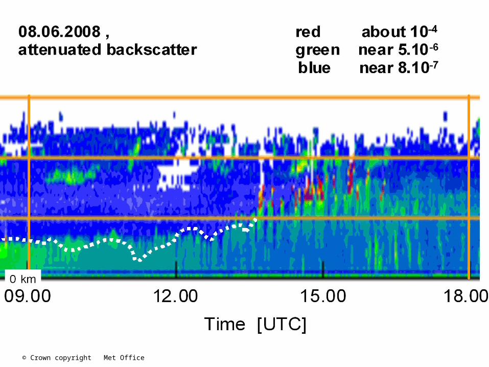
• Microwave radiometers are one of the types of observing system that will be considered for integrated profiling sites and for some GRUAN sites.
• The next slide shows high temporal resolution microwave radiometer observations from an earlier field experiment in the UK
• The following slide shows the radiosonde measurements made from the same site during the same time period.

© Crown copyright Met Office
New Visualisation plots DevelopedFor use with all types ofRadiometer.
Owen Cox
Low cloud presentSeveral timesBelow 2km during this period
Sea breeze front

© Crown copyright Met Office
Radiosonde measurements give vertical profiles with highervertical resolution than the radiometer , but the radiosonde samples do not show the low cloud
13 July 2005

© Crown copyright Met Office
• The Action is to concentrate on providing measurements from integrated profiling systems of the following key atmospheric variables,
clouds, wind, temperature and humidity.
• Long term deployments (testbeds) of combinations of observing systems will be used to check the cost-effectiveness, cost efficiency and practicality of the systems.
• The testbed experiments are to be used to generate data sets that can be exploited by new data assimilation techniques, so the Action intends to foster co-ordination between the observing system designers and operators and the users of the data , especially in numerical weather prediction.

© Crown copyright Met Office
• The instruments working group is intended to deal with further development of basic remote sensing systems towards the standards required for the operational networks
• Data assimilation working group tasks will be to design techniques to assimilate observations [especially vertical profiles], looking at developments required for future high resolution numerical weather prediction models.
• Observing experiments will be responsible for co-ordinating the test bed operations, including design of the experiments, practical implementation and generation of data bases suitable for the data assimilation group to exploit It will also need to work very closely with the data evaluation group.
• The Optimum observation network group is intended to examine methods of improved integration from groups of observing systems at a given site and also to work on methods of producing the best estimate of horizontal variation in the profiles around the integrated profiling site, utilising the observing experiments

© Crown copyright Met Office
An example of a new measurement to be investigated in the Action is high temporal resolution
vertical velocity measurements
by optical lidars in the boundary layer
and how they can be used with other measurements to define the
depth of the convective boundary layer
And can operational windprofilers be configured to measure these vertical velocities successfully?

© Crown copyright Met Office
Use vertical velocity measurements to investigate depth of convective boundary layer, courtesy of Reading Univ.
Halo Photonics lidar
© Crown copyright Met Office

© Crown copyright Met Office
Operational wind profiler
Wind profiler is starting to resolve vertical velocity fluctuations at this temporal resolution and suggests convection starts at about 07.30

© Crown copyright Met Office
AlsoSignal to noise in the wind profiler measurements also contains Information relevant to detecting the development og the boundary layer

© Crown copyright Met Office
Proposed FUND TESTBED operations
• To be operated for a minimum of 2 years
• Special installations around London to provide data for resolving questions about observation user requirements for future high resolution models
• Full set of profiling observations at Wattisham.
• Full set of profiling observations at Chilbolton as long as planning application is successful
• UFAM [Manchester University] wind profiler at Cardington for part of the time.
• AMDAR from probably four locations
• Integrated profiling site near central London may be funded by another Met Office project in 2010
• Minimum of 3 doppler radar winds.

© Crown copyright Met Office
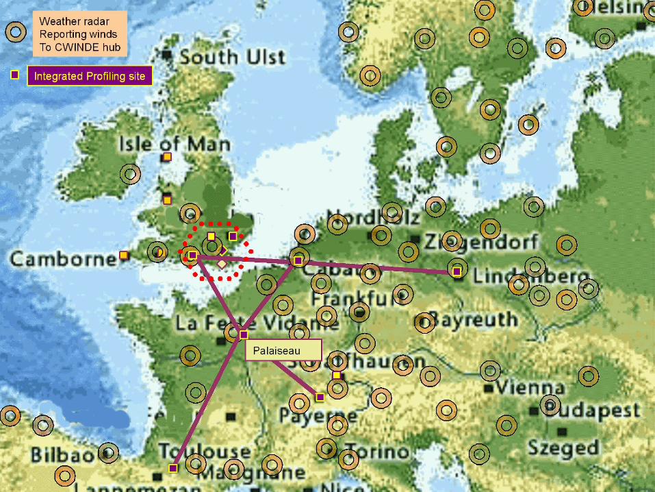
Chilbolton
Wattisham
Herstmonceux
Cardington
Dunkeswell
Cobbacombe Cross
Dean Hill
Clee Hill
Chenies
© Crown copyright Met Office
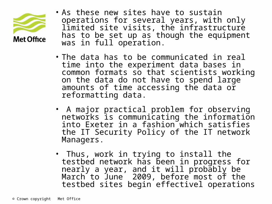
• As these new sites have to sustain operations for several years, with only limited site visits, the infrastructure has to be set up as though the equipment was in full operation.
• The data has to be communicated in real time into the experiment data bases in common formats so that scientists working on the data do not have to spend large amounts of time accessing the data or reformatting data.
• A major practical problem for observing networks is communicating the information into Exeter in a fashion which satisfies the IT Security Policy of the IT network Managers.
• Thus, work in trying to install the testbed network has been in progress for nearly a year, and it will probably be March to June 2009, before most of the testbed sites begin effectivel operations

© Crown copyright Met Office
Some International links• COST Action ES0604, Atmospheric Water Vapour in the
Climate System (WaVaCS), http://www.isac.cnr.it/wavacs/
• COST 731 Propagation of Uncertainty in Advanced Meteo-Hydrological Forecast systems, with the main objective to study issues associated with the quality and uncertainty of meteorological observations from remote sensing and other potentially valuable instrumentation.
• CIMO has been authorised to work on testbed experiments to improve the use of insitu and ground based remote sensing instrumentation. So it is intended that the UK Testbed phase of EG-CLIMET be nominated as a UK WIGOS Demonstration project.
• Lindenberg Observatory in Germany is the nominated Lead Centre for the development of the GRUAN network for WMO/GCOS. This centre is collaborating with Action ES0604, and it is expected that the activities will also link to some of the EG-CLIMET investigations.
© Crown copyright Met Office
Questions & answers

© Crown copyright Met Office
How can the proposed UK testbed link with other observations and planned activities in Europe?
© Crown copyright Met Office

© Crown copyright Met Office
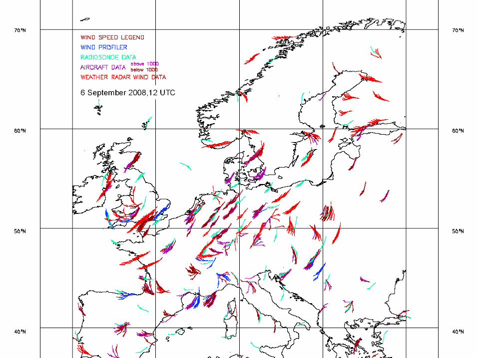
• Existing operational upper air observations for wind and water vapour
© Crown copyright Met Office

© Crown copyright Met Office
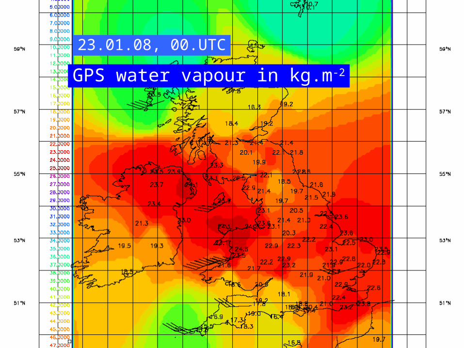
GPS water vapour processing is operational over the UK

© Crown copyright Met Office
00.UTC
GPS water vapour in kg.m-2

© Crown copyright Met Office
08.UTC
GPS water vapour in kg.m-2
© Crown copyright Met Office

© Crown copyright Met Office
12.UTC
GPS water vapour in kg.m-2

© Crown copyright Met Office
18.UTC
GPS water vapour in kg.m-2
© Crown copyright Met Office
23.01.08, 00.UTC
GPS water vapour in kg.m-2

© Crown copyright Met Office