* geology of the rogers lake and kramer quadrangles california … · the principal structural...
TRANSCRIPT

* Geology of the Rogers Lake and Kramer Quadrangles CaliforniaBy T. W. DIBBLEE, Jr.
GEOLOGIC INVESTIGATIONS OF SOUTHERN CALIFORNIA DESERTS
GEOLOGICAL SURVEY BULLETIN 1089-B
A study of an area in the central part of the western
* Mojave Desert
UNITED STATES GOVERNMENT PRINTING OFFICE, WASHINGTON : 1960

UNITED STATES DEPARTMENT OF THE INTERIOR
FRED A. SEATON, Secretary
GEOLOGICAL SURVEY
Thomas B. Nolan, Director
For sale by the Superintendent of Documents, U.S. Government Printing Office Washington 25, D.C. - Price $1.25 (paper cover)

CONTENTS
PageAbstract__--..__._._.__----_-_ ___._._._. ___._._ 73Introduction.____.________-_-__-_-_--_-----------_----_-__ _____ 74
Location and extent._____---_----_-----------_--_-____________ 74Purpose of inve8tigation____--_-___~_--_----_-__---_--_________ 74
' Previous work________________-_--_ -_-_--___-__-___.______ 76Present investigation and acknowledgments.______________________ 76
Geography and topography. _______ _. _-----------_-________-_ 77Regional geologic setting.________ __-_---_-__-_-----_______-_-___ 78Stratigraphy ___ __ ._-_ _ ..________ 78
Pre-Tertiary crystalline rocks---__-_----_----_-_----_--___-_-___ 79Metamorphic rocks._-__----_-_-------_____________________ 79
V Oro Grande(?) series of Hershey (1902) ___________. 79. Hornblende schist__-_--_----_------.----_-_---__-___._ 81
Intrusive rocks_-_-_--_--_--_------__-------__----_____-___ 82Hornblende diorite____.__---__-_-_-----____.._____._'_ 82Quartz monzonite____-______--_-_---_--__-_-___.______ 83
..-, ., Granite.___-___-____--__--__-_-_--_----,_----_____-_-_ 84Pegmatite-aph'te__ ___________________________________ 85
./ Quartz latite__-__--------_--__-------_--_----_________ 86Tertiary sedimentary and volcanic rocks__----__-____--_________ 87
Tropico group___________________________________________ 87Nomenclature and distribution._---_---__-_.____.____.__ 87Exposures in Bissell Hills.-_-__-_--_-_--___-_-__________ 87Exposures in Kramer Hills__--_-_-_-__-_-__-_________ 88
* Volcanic rocks__-_---_-_-_--_----_----_----_____.____. 99Possible relations of Bissell Hills and Kramer Hills exposures - 103
Quaternary rocks_________-____-__-_-_----__-_____-_-__________ 104Fanglomerate ___-__-_-_--_-_-__----____-_-_-_-__-_________ 104Older alluvium..________--.------._--.__________ 108Alluvium________...___-------_____.--_.___ 109
Structure. ---_----_-------___-----------------_--------_-___-_____ 113+ Metamorphic rocks-_---------_---------------------_---_____-- 113
Cenozoic deformation__-_______-____-__-_---_-___________-_____ 113Antelope Valley area____-__-__-___--_-_-_--_-_--_-_________ 114Hills west of Rogers Lake._-_-__---_____-_-_---_-__-______. 114Highlands east of Antelope Valley-_--_-----__-_--________-__ 115Kramer Hills area__--_---_-_-------_-_-_---------_-_-_____ 118Area north of Kramer Hills_----_-_--_----_---_--_--_____-__ 121Area northeast of Rogers Lake.-_---____-__------_-_-_______ 122
Geologic history___. _ ._ -__.___--_ _________ . 123Pre-Tertiary deposition______-__.__.-__-_-__.--___._____._.__ 123Mesozoic diastrophism._____--_______-----__-___-___-__________ 123Late Mesozoic and early Tertiary erosion____-___._._.____________ 123Tertiary deposition, volcanism, and diastrophism.._--_-___._______ 123Quaternary diastrophism, erosion, and deposition..________________ 125Later geomorphologic development_-_--_----_-_----_-_-__-______ 125
Erosion and topography____________-_-_________________.--^ ]25Drainage--------------.---------------------.---------.-. 126
ni

IV CONTENTS
Page Mineral resources._________________________________-___.___________ 129
Gold prospects____.-__-__.____-_____-_-________-__-_--________ 129Radioactive minerals_-_-________________-________-.-__---_____ 129Limestone, dolomite, and magnesite____________________________ 131Feldspar_____________________________________ 131
: Quartz_________________________.________ 131Ornamental stones__ -__-___--________________-_--__-_--____-_-- 131
-. Clay.__________________._________.______._,__-_-_-___.___ 132Possible saline deposits_-____-_-___-__---__-__-,___-.._-_--_-:-_-- 132
References cited.________________________-_-__--_-----_---------_-- 136Index ________________-____-__________________-_-_--__----_--_-_-- 137
PLATE 7. Generalized geologic map of the Mojave Desert region.8. Geologic map and sections of the Rogers Lake and Kramer quad
rangles.9. Geologic map of part of the Kramer Hills; Page
FIGURE 3. Index map of the Mojave Desert and vicinity.____-__-______ 75j 4. Correlation chart of sections of the Tropico group in the Kramer
Hills._._________. __-___-_____-__-__-_----____ -_--_. 96

GEOLOGIC INVESTIGATIONS OF SOUTHERN CALIFORNIA DESERTS
GEOLOGY OF THE ROGERS LAKE AND KRAMER QUADRANGLES, CALIFORNIA
By T. W. DIBBLEE, JR.
ABSTRACT
The Rogers Lake and Kramer quadrangles cover about 490 square miles in the western Mojave Desert, California. The area includes the extreme north east part of Antelope Valley, in which lies Rogers Lake (dry) and parts of the gently undulating hills to the northwest and east; its central part is about 80 airline miles northeast of Los Angeles. Altitudes above sea level range from 2,271 feet at Rogers Lake to 3,426 feet at Red Buttes.
The rOck units of the area may be grouped into three main divisions that are separated by major unconformities. These divisions are: pre-Tertiary crystalline rocks; Tertiary volcanic, pyroclastic, and sedimentary rocks; and Quaternary alluvial sediments.
The pre-Tertiary crystalline complex is composed mainly of plutonic igneous rocks ef probable late Mesozoic age or older, which include hornblende diorite, quartz inonzonite, and granite. Of these, qUartz monzonite is by far the most prevalent; it crops out over large areas. In some places these rocks are cut by dikes of pegmatite-aplite and quarte latite. The north end of a large pendant of metamorphic rocks, composed of schist, hornfels and lime stone of late Paleozoic (?) age, crops out. in the extreme southeastern part of the area.
Strata of Tertiary age crop out in the Kramer Hills in the easternmost part of the area and also in the extreme northwestern corner, and are mapped as the Tropico group. In the Kramer Hills this group is about 2,600 feet in maximum thickness and consists of three mappable units or parts. The lower part is a sequence of fluviatile and lacustrine strata aggregating 1,600 feet in maximum thickness that is locally divisible into the following units in ascending order: tuff-sandstone, limestone-chert, sandstone-shale, dolomite, and shale. Flows of basalt are locally present in this sequence. The middle part, or the Red Buttes quartz basalt flow, is about 200 feet in maximum thickness and lies unconformably on the lower.part. The upper part of the Tropico group consists mainly of sandstone and shale of terrestrial origin with a maximum exposed thickness of about 800 feet.
The Quaternary deposits consist of coarse granitic fanglomerate of prob able Pleistocene age and alluvium of late Pleistocene and Recent ages. The fanglomerate is more than 1,000 feet thick; it lies unconformably on the Tertiary and pre-Tertiary rocks and is locally deformed and dissected. The alluvium is about 200 feet thick; it occurs as valley fills and is undeformed.
The principal structural features of the area are several broad upwarps
73

74 GEOLOGY OF SOUTHERN CALIFORNIA DESERTS
and downwarps with no definite elongation. The upwarps coincide with low hills that expose mainly pre-Tertiary massive granitic rocks; in places these crystalline rocks are overlain by Tertiary stratified rocks that are tilted, folded, and faulted. The intervening downwarps form the valleys and are filled with Quaternary alluvial sediments. The area is cut by high-angle faults that trend northwest and north of east. Several of these faults partly transect the upwarped areas and a few partly bound them, but none form prominent scarps.
The intense diastrophism and the batholithic invasion by plutonic rocks in Mesozoic time in this area were followed by a long interval of erosion during Cretaceous and early Tertiary times. Sedimentation on the deeply eroded surface of the crystalline rocks started probably in mid-Tertiary time with deposition of the Tropico group, under subaerial conditions, of coarse detrital sediments, and of rhyolitic ash emitted from nearby volcanic vents; deposi tion of fluviatile and lacustrine sediments of the Tropico group in enclosed basins and extrusion of some basic lava flows soon followed.
Probably in early Quaternary time, or after deposition of the Tertiary rocks, the surface of the crystalline rocks was warped, and in the upwarped areas the Tertiary rocks were deformed. Probably these areas were elevated to high relief, permitting widespread erosion of the Tertiary and pre-Tertiary rocks. The eroded detritus was deposited in the adjacent downwarped areas or basins. Near middle Pleistocene time a minor recurrence of uplift of the elevated areas caused local disturbance and erosion of the earlier Quater nary sediments. During late Quaternary time relative stability prevailed in this area, and the elevated areas were eroded to their present low relief.
The mineral resources in the area include deposits of pegmatite-feldspar and quartz, deposits of andesitic volcanic rock suitable for road material, large deposits of clay, deposits of dolomitic marble and of fresh-water lime stone and dolomite, ornamental siliceous stones, and occurrences of magnesite and of radioactive minerals.
INTRODUCTION
LOCATION AND EXTENT
The Kogers Lake and Kramer quadrangles, California, are ad joining 15-minute quadrangles between longs 11T°30' and 118° W. and between lats 34°45' and 35° N. as shown in figure 3. The area is in parts of Kern, San Bernardino, and Los Angeles Counties. It is centered about 80 miles northeast of Los Angeles by airline, about 120 miles by road
PURPOSE OF INVESTIGATION
The geologic maps of the Rogers Lake and Kramer quadrangles (pi. 8) accompanying the present report are two of several quad rangle maps being prepared by the U.S. Geological Survey that show the areal geology of the western Mojave Desert.
The principal objective of this work was the study of the Ter tiary and Quaternary formations to determine whether they may contain undiscovered saline deposits of economic value such as those in other parts of the Mojave Desert.

ROGERS LAKE AND KRAMER QUADRANGLES 75
FIODRB 3. Index map of the Mojave Desert and vicinity, California, showing loca tion of Rogers Lake and Kramer quadrangles.
Another aim, less pressing but with an important bearing on the study of the depositional history and structure of the Cenozoic for mations, was to determine the general character of the pre-Tertiary crystalline bedrock complex within the two mapped quadrangles. A third objective was to describe briefly the known mineral deposits within the area; the description is based largely on published sources.

76 GEOLOGY OF SOUTHERN CALIFORNIA DESERTS
PREVIOUS WORK
The only published reports that deal with the geology of any part of the area covered by the Rogers Lake and Kramer quadran gles are one by Johnson (1911), which outlines the general struc tural features and ground-water conditions of Antelope Valley, and one by Thompson (1929, p. 289-371), which similarly treats the entire Mojave Desert.
Several maps and reports dealing with the geology of areas ad joining the Rogers Lake and Kramer quadrangles have been pub lished. The earliest of these, by Simpson (1934, p. 371-415, pi. 5), covered the 30-minute Elizabeth Lake quadrangle, part of which adjoins the Rogers Lake quadrangle on the west. A reconnaissance geologic map of the Kramer borate district north of Boron by Rubey and Callagan (in Hewett and others, 1936, p. 98-105, pi. 1) accompanied a report that described the borate deposit. In 1946 Gale (p. 325-378) mapped this district in detail on a topographic base. The geology of the 30-minute Barstow quadrangle, part of which adjoins the Kramer quadrangle on the east, was mapped and described by Bowen (1954). The geology of part of the Shadow Mountains, which lie south of the Kramer quadrangle, was mapped and described in detail by Troxel (1954, map sheet 15).
PRESENT INVESTIGATION AND ACKNOWLEDGMENTS
Fieldwork in the Rogers Lake and Kramer quadrangles was done by the writer in January and February 1953. The geology was mapped on aerial photographs and transferred to the topographic maps of the 15-minute 1:62,500-scale Rogers Lake and Kramer quadrangles issued in 1942. These quadrangle maps were revised in 1956 and reissued in 1957.
The igneous rocks of the area were identified from their mineral content as determined in the laboratory by Robert D. Alien and Frank M. Byers, Jr. Subsurface structural interpretations are based in part on data from a geophysical (gravity-meter) survey of the western Mojave Desert by Don R. Mabey and his assistants, and frequent discussions with him have been of great help. The writer is also indebted to Siegfried J. Muessig and Kenneth E. Lohman for field checking and for helpful discussions and advice concerning the Tertiary stratigraphic problems of the area. Two exploratory wells for saline deposits were drilled in the area; Mr. Lohman col lected many samples of Tertiary limestones and shales from which he unsuccessfully attempted to obtain a diatom flora that might de termine the age of the formation; two test holes in the area were logged by Dayton D. Dickey (1957) and William K. Benda.

ROGERS LAKE AND KRAMER QUADRANGLES 77
The Rogers Lake and Kramer quadrangles have a general low relief and therefore a monotonous aspect. Among the few more prominent uplands are the Kramer Hills in the northeastern quarter, the rocky hills in the southwestern quarter, the north flank of the Shadow Mountains in the southeastern corner of the Kramer quadrangle, the eastern part of the Bissell Hills in the north western quarter, and the low domelike highland in the southeastern quarter of the Eogers Lake quadrangle (pi. 8). Altitudes above sea level range from 2,271 feet at Rogers Lake to 3,426 feet at Red Buttes, with a maximum relief of 1,155 feet.
Topographic features reflect the geologic structure, which varies from place to place, and also the relative hardness and coherence of the many different rock strata. Hard, weather-resistant car bonate (limestone and dolomite) and chert layers, dike-forming pegmatite-aplite and quartz latite, and quartz basalt crop out as conspicuous ledges, ridges, and hills. Layers of calc-silicate horn- fels, though also resistant to weathering, are closely jointed and break into small fragments, hence form less prominent ledges. Quartz monzonite, hornblende diorite, and hornblende schist disin tegrate mechanically to small fragments or residual sands; together with such weakly resistant rocks as schist, clay shale, semifriable sandstone, and tuff, their outcrops are of low relief. The granite in the northwestern quarter of the Rogers Lake quadrangle weathers to low relief, whereas that east of northern Rogers Lake and in the southwestern part of the Kramer quadrangle crops out prominently to form steep-sided jagged rocky hills.
The only town of any size within the area is the military town of Edwards, which serves as headquarters of the Edwards Air Force Base, and in 1954 had about 3,000 inhabitants. Boron (formerly Amargo) with about 500 inhabitants is at the north border of the Kramer quadrangle. In addition there are small settlements at Kramer, 3 miles east, and Kramer Junction (known also as Four Corners), 6 miles east of Boron.
Most of the mapped area now lies within the military reservation of the Edwards Air Force Base and is closed to public entry. In the extreme southern part of the Kramer quadrangle are many small homestead ranches. There are others in the level lands of Antelope Valley in southwestern Rogers Lake quadrangle; these are, or have been, cultivated, and the ground-water resources of this valley have been drawn for use in irrigation of alfalfa, cotton, barley, and other crops.
The Atchison, Topeka, and Santa Fe Railway and U.S. Highway 466, parallel to the railway, cross the northeastern corner of the
548598 61 2
78 GEOLOGY OF SOUTHERN CALIFORNIA DESERTS
Kramer quadrangle. The railroad formerly crossed Rogers Lake, as shown on the 1942 edition of the topographic map, but has since been moved just north of the mapped quadrangles. The eastern part of the area is transversed by U.S. Highway 395. Many sec ondary roads cross both quadrangles.
The mapped area is in a region of arid climate. Summers are hot, with maximum daytime temperatures in the 100°-115° range. Winters are mild to cold, with night temperatures falling below freezing, sometimes as low as 12°. Precipitation is almost entirely in the form of rainfall, but this seldom exceeds 5 inches annually. Nearly all comes during the winter and spring months from cyclonic storms which are accompanied or followed by strong westerly gales.
Vegetation in this desert area is of the usual sparse low brush; burro and creosote bush are the most prevalent. Giant yuccas or Joshua trees and bunch grass are abundant on sandy areas at alti tudes above 2,800 feet. One of the densest stands of Joshua trees in the Mojave Desert covers the broad sandy slopes between Rogers Lake and the vicinity of Haystack Butte. The dry lake beds throughout the area are devoid of vegetation.
REGIONAL GEOLOGIC SETTING
The area discussed in this report is in the west-central part of the Mojave Desert block about midway between the bounding Gar- lock and San Andreas faults; it is centered about 65 miles east of their junction. This block is cut by numerous high-angle faults, most of which trend northwestward parallel to the San Andreas; several are within the Rogers Lake and Kramer quadrangles. The geologic setting of the two quadrangles is shown on plate 7.
The rocks generally present in the western Mojave Desert region may be grouped into three main divisions: granitic and meta- morphic rocks of pre-Tertiary age; volcanic, pyroclastic, and sedi mentary rocks of Tertiary age; and alluvial sediments of Quaternary age.
STRATIGRAPHY
Within the Rogers Lake and Kramer quadrangles are rocks of all three main age divisions and of almost all the rock types listed in the preceding paragraph. The ages of the units mapped are in ferred from geologic relations because no indigenous fossils were found in any of them.
The pre-Tertiary crystalline rocks are mostly granitic intrusions like those of the Sierra Nevada granitic batholith of supposed Late Jurassic or Early Cretaceous age. Quartz monzonite is by far the most prevalent granitic rock and crops out over large areas; granite

ROGERS LAKE AND KRAMER QUADRANGLES 79
and hornblende diorite underlie small areas. The metamorphic rocks that are inferred to be of Paleozoic age are confined to a pendant in the Shadow Mountains, a small part of which is within the south east corner of the Kramer quadrangle.
The rocks of Tertiary age are confined mainly to the extreme eastern part of the area and are composed of about 2,600 feet of volcanic, pyroclastic, and nonmarine sedimentary rocks of probable Miocene and Pliocene age. This assemblage of strata rests uncon- formably on the granitic bedrock complex, and it includes several locally mappable units. The volcanic rocks range from basalt to quartz latite; they occur as flows intercalated in the sedimentary strata and as local intrusions in both the Tertiary and pre-Tertiary rocks. The sedimentary rocks range from carbonate rock and shales to conglomerates and are of lacustrine and fluviatile origin.
The alluvial sediments of Quaternary age lie unconformably on the Tertiary and pre-Tertiary rocks; in the valley areas they aggre gate more than 1,000 feet in thickness. They are all clastic sedi ments derived from the underlying pre-Tertiary bedrock complex and Tertiary rocks and range from fanglomerates to fine clays.
PRE-TERTIARY CRYSTALLINE ROCKS
METAMORPHIC ROCKS
ORO GRANDE (?) SERIES OF HER8HEY (1902)
Metamorphic rocks including limestone, dolomite, hornfels, schis tose hornfels, and quartzite crop out in the southeast corner of the Kramer quadrangle as the northern fringe of a large pendant within granitic rocks in the Shadow Mountains. These metasedimentary rocks were mapped by Troxel (1954) who referred them to the Oro Grande series on the basis of their lithologic similarity to the series at its type locality on Quartzite Mountain east of Oro Grande (Hershey 1902, p. 287-288. See also Bowen, 1954, p. 24-25, pi. 1).
The age of the rocks assigned to Hershey's Oro Grande(?) series in the Kramer quadrangle is not certainly known. The rocks are older than the granitic rocks of Jurassic to Cretaceous age that intrude them. Their lower age limit is uncertain, but they lack the gneisses and coarse mica schists characteristic of Precambrian rocks of the Mojave Desert region and are therefore presumed to be younger. In the southeastern part of the Shadow Mountains, rocks of similar lithology believed to be correlative have yielded from one locality poorly preserved brachiopods and crinoid debris that C. W. Merriam (in Bowen, 1954, p. 34) assigned to the Car boniferous, most probably Pennsylvania!!. It should be emphasized, however, that this date may not apply to the entire section and pre- Pennsylvanian rocks may be included.

80 GEOLOGY OF SOUTHERN CALIFORNIA DESERTS
McCulloh (1954, p. 15-17) pointed out that there is a striking contrast between the Paleozoic rocks of the eastern part of the Mojave Desert and those of the central part. With the exception of those of the predominantly clastic lower part of the Cambrian, the Paleozoic rocks of the eastern Mojave are characteristically car bonate and those of the central Mojave are clastic and volcanic as well as carbonate; the section thickens and coarsens notably to ward the west. The Oro Grande series belongs to the central Mojave facies.
In the central Mojave area neither the top nor the base of the section is exposed. Troxel's map (1954, map sheet 15) of the Shadow Mountains beyond the border of the quadrangle indicates that the structure is an overturned anticline whose axis is south west of hill 3325; the strata northwest of this axis, which in the Kramer quadrangle dip southeastward, must therefore be over turned. About 2,600 feet of beds is exposed on the southeast flank of the anticline east of hill 3325 and about 2,000 feet on the over turned northwest flank (pi. 8).
The Oro Grande(?) series exposed in the northern part of the Shadow Mountains consists of alternating crystalline limestone and dolomite, mica-quartz schist, and calc-silicate hornfels, in about equal proportions, and a minor amount of quartzite in small lenses. Individual units range from a few feet to 600 feet in thickness. The sequence of strata is not definitely known, but on the southeast flank of the anticline the lowest exposed strata are just south of hill 3325 and are mostly beyond the south border of the quadrangle; they consist of about 500 feet of calc-silicate hornfels with thin layers of quartzite. This is overlain by several hundred feet of mica-quartz schist, which in turn is overlain by about 200 feet of calc-silicate hornfels and quartzite. Above this is about 400 feet of white dolomite that forms the crest and highest peak of the mountains just beyond the south border of the quadrangle. The dolomite layer is overlain by about 1,500 feet of alternating layers of quartz-mica schist and dolomite-limestone that is exposed at the southeast corner of the Kramer quadrangle. The overturned se quence exposed on the northwest flank of the anticline is composed of about 2,000 feet of alternating thick layers of quartz-mica schist and white dolomitic limestone marble.
The carbonate rocks of the Oro Grande(?) series occur as layers 1 to 400 feet thick. They are white but weather light gray on the surface, and are massive to well-stratified fine to coarse-crystalline marbles. The grain size ranges from 1 to 5 mm, with the coarser varieties generally near granitic contacts. Most layers are com posed of calcite with admixtures of dolomite; others are nearly
ROGERS LAKE AND KRAMER QUADRANGLES 81
pure dolomite. Near granitic contacts the carbonate rocks locally contain calc-silicate minerals such as wollastonite, garnet, idocrase, and epidote.
The calc-silicate hornfels consists of well-stratified hard layers, 1 inch to several feet thick, that weather with platy fracture paral lel to bedding. The rock is dense to fine grained, massive to faintly laminated, with colors ranging from gray to light green, brown, or pink. It is composed almost entirely of lime-silicate minerals, mainly garnet and epidote, and finely divided mica and quartz. Commonly interstratified with these hornfels layers are thin layers of white limestone marble, brown mica-quartz schist, and gray quartzite.
The mica-quartz schist is a dark-gray rock that weathers dark brown. It is fine to medium grained, with average grain size about 1 mm or slightly less, and massive to crudely foliated with weak schistose cleavage parallel to bedding. Some linear structure is locally developed. This rock consists mainly of muscovite, biotite, and quartz. The mica flakes are oriented both parallel to bedding and at random. Iron oxides, mostly limonite, also are present and give the rock its dark color. One sample contains anthophyllite; another contains epidote in addition to quartz, mica, and limonite.
The quartzite is a light-gray massive to faintly laminated glassy rock. It is closely jointed and breaks into small fragments so that it does not form prominent outcrops. The largest quartzite lens is about 100 feet thick; thin lenses of quartzite are in calc-silicate hornfels layers.
HORNBLENDE SCHIST
Hornblende schist, which crops out in the Kramer Hills at the east border of the Kramer quadrangle, has been intruded by quartz monzonite and is overlain on the southwest by Tertiary rocks. In the Barstow quadrangle the schist was mapped as part of the Side winder volcanics by Bowen (1954, pi. 1) and assigned to the Triassic.
Fresh exposures of this rock can be seen only in gullies or prospect shafts. The fine-grained phases break into small fragments, and the coarse. phases disintegrate mechanically to dark-gray sandy soil.
The hornblende schist is dark gray to black and of fine to me dium.-texture with grain sizes ranging from less than 1 to 3 mm. It is generally homogeneous, but in places its coarse phases show an indistinct gneissic banding. The foliation is generally vertical and strikes about N. 70° E. Commonly a lineation that dips east ward has been formed in the foliation planes.
The hornblende schist is composed mainly of hornblende and lesser ,but variable amounts of biotite, feldspar, and quartz. The

82 GEOLOGY OF SOUTHERN CALIFORNIA DESERTS
hornblende crystals are oriented either at random or with their long axes more or less parallel to give the rock its crude linear foliation. Modal analysis of a sample of the hornblende schist gave the fol lowing mineral percentages: hornblende, 65 percent; plagioclase (andesine), 25 percent; orthoclase and quartz, 9 percent; unidenti fied opaque mineral, 1 percent. The high percentage of hornblende and low percentage of biotite suggest that the schist may have been formed by metamorphism of an igneous rock, such as andesite, basalt, or diabase.
INTRUSIVE ROCKS
Contacts between the various plutonic intrusive rocks are in places sharp and well defined; in others they are gradational and indistinct. Field relations as described hereafter suggest the fol lowing sequence of emplacement of the plutonic rocks: (a) horn blende diorite, (b) quartz monzonite, (c) granite, and (d) pegmatite- aplite.
Although the age of the plutonic rocks within the two mapped quadrangles is not certain, the quartz-bearing granitic intrusive rocks within the western Mojave Desert are probably of the same age as similar granitic rocks of the Sierra Nevada to the north that is, Late Jurassic or Early Cretaceous. Age of samples from several localities within the western Mojave Desert, including one of quartz monzonite from a locality 4 miles northeast of Rosa mond, was determined by the Larsen lead-alpha method on zircon concentrates to range from 86 to 112 million years, which is within the Cretaceous period (W. C. Schlect, written communication to W. C. Smith, Mar. 13, 1957).
HORNBLENDE DIORITE
Hornblende diorite occurs in the Kramer quadrangle as many small bodies within quartz monzonite near Red Buttes and about 3 miles south of Kramer. These bodies are elliptical in shape; the largest underlies about 50 acres of ground. Though the rock disintegrates rapidly, the dark color of its exposures is conspicuous.
Near Red Buttes the bodies of hornblende diorite are elongate northeastward and some are alined in that direction. Similar small masses of hornblende diorite in the central Shadow Mountains were considered by Troxel (1954, map sheet 15) to be intrusive into the enclosing quartz monzonite, but in the Red Buttes area some have been cut to pieces by the quartz monzonite. These relations sug gest that the small alined bodies of hornblende diorite are relict masses of a once larger body of mafic rock engulfed by the quartz monzonite.
The hornblende diorite is a dark-gray to nearly black medium- textured rock. It is composed mainly of black hornblende and
ROGERS LAKE AND KRAMER QUADRANGLES 83
grayish-white plagioclase feldspar in generally equal proportions. The hornblende forms stubby anhedra that are intergrown with the plagioclase. The hornblende and plagioclase anhedra are equi- dimensional and average from 2 to 4 mm. Some exposures contain, in addition to hornblende and plagioclase, small amounts of epidote, garnet, calcite, and quartz.
QUARTZ MONZONITE
The quartz monzonite is exposed extensively in the low hills west, east, and southeast of Rogers Lake. Other exposures are in the western and northeastern Kramer Hills and in a low hill 2 miles east of Kramer Junction.
In the arid, desert climate the quartz monzonite disintegrates mechanically to form coarse residual sand (grus) which on lower slopes locally blends into the alluvial sands of the adjacent valleys.
The quartz monzonite exposed within the mapped quadrangles is part of an extensive generally uniform batholithic mass that underlies most of the western Mojave* Desert either at the surface or at depth. Its intrusive relation with the metamorphic rocks of the Shadow Mountains and the hornblende diorite near Red Buttes were described on pages 79 and 82.
The quartz monzonite is gray white and is composed of quartz, white feldspar, and biotite; it commonly weathers light buff, espe cially on joint surfaces. In most places the rock is massive, but in a few places in the vicinity of Mount Mesa and in the hills north of Buckhorn Lake it is indistinctly gneissoid. The texture of the rock is typically granitic and medium to coarse grained equi- granular, with quartz and feldspar grains ranging from 1 to 4 mm across. In some places the rock contains rare feldspar phenocrysts as long as 10 mm.
In the large exposure of quartz monzonite south of Kramer and Boron there is a more mafic local phase that is most conspicuous on the low ridge about 3 miles south of Boron. It is also conspicuous in the low hills east of northern Rogers Lake, and very small ex posures occur within granite in Leuhman Ridge and in the hill north of it. This darker phase, which may be granodiorite or even quartz diorite, contains hornblende and also a larger percentage of biotite than does the normal quartz monzonite. In most exposures the biotite tablets and hornblende crystals are oriented almost parallel to give the rock an indistinct planar to linear gneissoid foliation. In nearly all exposures where this rock is foliated the planar foliation trends northwestward.
A fresh typical sample of quartz monzonite from a deep shaft 2 miles north of Red Buttes is composed of essential minerals in the following percentages: quartz, 26; orthoclase, 29; plagioclase

84 GEOLOGY: OF SOUTHERN CALIFORNIA DESERTS
(oligoclase), 41; biotite, 4. A sample from a quarry 2 miles south west of Mount Mesa has the following percentages: quartz, 22; orthoclase, 28; plagioclase (oligoclase), 45; biotite, 5; accessory minerals, less than 1. The compositions indicate both these sam ples to be quartz monzonite near granodiorite. Another sample from an outcrop 2 miles northeast of Mount Mesa has the following per centages: quartz, 26; orthoclase, 15; plagioclase (oligoclase-andesine), 47; biotite, 3; hornblende, 7; accessory minerals (including apatite and sphene), 3. The relatively high percentage of plagioclase and low percentage of orthoclase in this sample indicate a composition of granodiorite. The rock from this locality contains rare scattered euhedral .phenocrysts of plagioclase (andesine) as much as 10 mm long.
In the quartz monzonite, the quartz is clear, glassy, and in sub- equarit anhedral grains that appear to fill spaces between subhedral grains of feldspar. The feldspars are cloudy and, because both types are white to cream white, they are difficult to distinguish. Biotite occurs as euhedral to subhedral tablets as much as 5 mm across and 1 mm thick. They are scattered singly throughout the rock and are rarely in clusters. Hornblende, where present, occurs as small-bladed prisms usually less than 5 mm long. Muscovite, sphene, and apatite are the most common accessory minerals.
GRANITE
The granite, together with its many dikes of pegmatite-aplite, is exposed in both quadrangles. It occurs as smaller masses within and probably intrusive into the quartz monzonite. In the hills west of Edwards the relationship of the granite to the quartz mon zonite is not clear, as the contacts appear to be gradational and are difficult to locate. In the hill 3 miles southwest of Boron the granite contains inclusions of gneissoid quartz monzonite as long as 50 feet. In the southwestern part of the Kramer quadrangle the granite is in the form of small stocks; it has offshoot dikes of pegmatite-aplite which are intrusive into massive quartz monzonite. In the northern foothills of the Shadow Mountains small stocks and offshoots of granite are intrusive into the metamorphic rocks. From these relations it is concluded that the granite is for the most part intrusive into and younger than the quartz monzonite.
The granite is a massive pinkish-white fine- to medium-grained rock, with grain sizes of 1 to 4 mm. It is composed almost entirely of anhedral and subhedral grains of quartz and alkali feldspar. The feldspar is cloudy and cream white to pale pink. The quartz is clear and glassy, and appears to fill spaces between the inter- grown subhedral feldspar crystals. The rock contains sparse small flakes of muscovite or biotite or both.
ROGERS LAKE AND KRAMER QUADRANGLES 85
A sample of granite from sec. 25, T. 8 N"., R. 8 W., consists of essential minerals in the following percentages, as determined from a thin section: quartz, 30; alkalic feldspar (orthoclase, perthite, and microcline), 65; plagioclase (albite-oligoclase), 5; micas, less than 1. A sample from the southwest corner and another from the southeast corner of sec. 32, T. 10 N., R. 10 W., contain the follow ing percentages as estimated from thin sections: quartz, 30; alkalic feldspar (orthoclase and perthite), 60 to 70; plagioclase (albite- oligoclase), 0-10; micas, less than 1; apatite, less than 1; opaque oxides, less than 1.
PEGMATITE-APLITE
The pegmatite-aplite is an inequigranular-textured granitic rock ranging from pegmatite to aplite, and occurs as dikes. In the southwestern part of the Kramer quadrangle dikeswarms of this rock are intimately associated with larger masses of granite and are intrusive into quartz monzonite. In other parts of the mapped quadrangles, such as near Leuhman Ridge and in the low hills west of Rogers Lake, pegmatite and some aplite occur only as scattered dikes, mostly in quartz monzonite.
The pegmatite-aplite rock is apparently the offshoot-dike phase of the granite from which it can be distinguished only with diffi culty. Both north and southwest of the main stock of granite in the southwestern part of the Kramer quadrangle there are smaller elongate bodies composed of mixtures of granite and pegmatite- aplite intrusive into quartz monzonite. The granite in some of these bodies grades into pegmatite and aplite; that in others is cut by dikes of these rocks. These offshoot bodies and dikes of pegmatite and aplite, most of which are intrusive into quartz monzonite, are generally parallel, and those north of the granitic stock trend gen erally northeastward to northward and dip steeply northwestward and westward. Those to the southwest are nearly vertical with a northwesterly elongation. The swarm of pegmatite-aplite dikes southwest of the Mirage Valley fault trend northwestward and dip gently southwestward. These may be offshoots from an unexposed granite stock to the southwest.
The pegmatite-aplite rocks, or at least those exposed in the south western part of the Kramer quadrangle, are of about the same mineralogical composition as the granite with which they are asso ciated in that area. Typical pegmatite-aplite rock is composed almost entirely of glassy quartz and cream-white to pale pink com monly perthitic potassium feldspar. The rock contains very little mica, mostly in the form of muscovite. The pegmatites are devoid of accessory minerals other than mica. A sample of graphic peg matite from sec. 25, T. 8 N., R. 8 W., contains the following per-
648598 61 3

86 GEOLOGY OF SOUTHERN CALIFORNIA DESERTS
centages as determined from a thin section: quartz, 30; potassium feldspar (orthoclase and perthite), 70; mica, rare. Pegmatite- aplite dike rocks in other parts of the mapped area may contain plagioclase (albite-oligoclase) feldspars and thus may approach quartz monzonite in composition.
The texture of the pegmatite-aplite dike rocks is highly variable in grain size and character. There are all gradations between coarse pegmatites with anhedral crystals measuring more than an inch across, through intermediate inequigranular medium-textured gran ites, to fine aplites with grain sizes of 1 mm or less. Zonal textural banding is formed in many of the dikes in which the internal parts are composed of coarse pegmatites, in the parts near the margins of alternating bands of finer pegmatites and inequigranular granites, and in the margins of finer granite and aplite. In all textural phases crystals are anhedral and intergrown. Graphic textures are very common in the pegmatites and inequigranular granites.
QUARTZ LATITE
The quartz latite occurs as scattered dikes in the quartz mon zonite in the low hills south of Kramer and Boron. The largest of these dikes, exposed 4 miles south of Kramer, reaches a maximum thickness of 500 feet, is traceable for a mile, and extends south eastward under Quaternary fanglomerate. The 2 easternmost dikes of a group 3 miles southwest of Kramer trend northward and are irregular intrusive bodies; others of the group trend northwestward to westward and dip 70° to 85° northward; the most westerly is traceable for nearly 2 miles. These dikes are planar sheets, some of which merge; they range in width from 0 to about 100 feet. The dike southeast of Leuhman Ridge trends north of east, dips steeply northwestward, and has a maximum width of about 70 feet.
The quartz latite is hard and resistant to weathering. Generally it weathers into small sharp angular fragments, but some dikes have jointing parallel to their outer walls; hence the rock fractures to platy slabs from less than an inch to about a foot thick.
In hand specimen the quartz latite is seen to be a hard massive very fine grained almost felsitic rock. It is rarely laminated, al though in some dikes weak flow laminae are locally formed parallel to the dike walls. The rock ranges from white to pale gray or pale bluish pink on fresh surfaces. Joint surfaces are commonly weath ered or stained pale buff to purplish brown, probably by iron oxides. Scattered throughout the very fine textured rock are micfopheno- crysts of clear quartz. These occur as subhedral crystals a quarter of a millimeter across and make up about 5 percent of the total rock mass. In addition there are scattered dark specks and flakes of hematite, possibly alterations after biotite. Also scattered through-

ROGERS. LAKE AND KRAMER QUADRANGLES 87
out the rock are vugs partly filled with a yellowish-white kaolinitic material. These vugs are of about the same abundance and size as the quartz microphenocrysts; the rectangular shape of many sug gests they were originally phenocrysts of feldspar that were altered and leached out. In some places the rock contains a few scattered euhedral phenocrysts of white feldspar about 1 mm long.
As seen under the microscope, the groundmass is anisotropic with an average index of about 1.535. It is probably composed of sub- microscopic potassium feldspar and sodic plagioclase partly altered to sericite. Hematite is present in minor amounts.
The age of the quartz latite in the Kramer quadrangle can be determined only as younger than the quartz monzonite (Late Juras sic or Early Cretaceous), which it intrudes, and older than the fanglomerate of Quaternary age that unconformably overlies it. The dikes of quartz latite are similar to those believed to be of late Cretaceous or early Tertiary age east of the map area in the vicinity of Harper Valley.
TERTIARY SEDIMENTARY AND VOLCANIC BOCKS
TROPICO GROUP
NOMENCLATURE AND DISTRIBUTION
All the terrestrial sedimentary, pyroclastic, and volcanic rocks of Tertiary age exposed in the Rogers Lake and Kramer quadrangles, as well as in the Rosamond and Willow Springs quadrangles to the west and in the Castle Butte and Boron quadrangles to the north, are included in the Tropico group by the writer in a previous pub lication (Dibblee, 1958, p. 135-144). In that paper reasons are discussed for the selection of the name and for abandonment by the U.S. Geological Survey of the earlier name Rosamond which has become so frequently and confusingly misapplied.
The age of the Tropico group within the mapped area is not known exactly, but it is almost certainly Tertiary, for there and elsewhere in the Mojave Desert the group rests on a deeply eroded surface of the Jurassic to Cretaceous granitic rocks and is overlain unconformably by Quaternary alluvial sediments.
The Tropico group crops out in the Bissell Hills at the northwest corner of the mapped area and in the Kramer Hills near the east edge. Because these exposed rocks are many miles apart and their stratigraphic sequences differ, the age relations between them are uncertain. Hence, details about the group are presented separately below for the two areas.
EXPOSURES IN BISSELL HILLS
The small isolated exposures of the Tropico group in that part of the Bissell Hills within the Rogers Lake quadrangle consist of
88 GEOLOGY OF SOUTHERN CALIFORNIA DESERTS
tuff, basalt, and lacustrine carbonate strata; they are partial sec tions with only a few hundred feet exposed. The group is more completely exposed to the west in the adjoining Rosamond quadran gle, where it was differentiated by the writer into a pyroclastic lower unit mapped as the Gem Hill formation, and an upper fluviatile and lucustrine sedimentary unit named the Bissell formation.
In the Rogers Lake quadrangle what is seen of the Tropico group is warped into a west-plunging syncline which is largely covered by Quaternary fanglomerate. On the east end of this syncline the pre-Tertiary quartz monzonite is overlain by about 25 feet of weathered fine-grained basalt traceable for about 1,000 feet along ^strike. The basalt is overlain by about 60 feet of white fine-grained .shaly tuff with several hard siliceous layers as much as 6 inches thick. Farther west this tuff forms the Gem Hill formation or the lower unit of the Tropico group.
On the north flank of the same syncline the quartz monzonite is overlain by about TO feet of hard dolomite and limestone in beds 2 to 20 inches thick and by interbedded soft clayey to hard thin- bedded siliceous shales. These carbonate and shale strata dip steeply southward and are overlain unconformably by Quaternary fanglomerate; they extend westward into the adjoining Rosamond quadrangle, where they were mapped as the carbonate and shale member of the Bissell formation and where they underlie tuff of the Gem Hill formation that appears under them just west of the quadrangle boundary.
EXPOSURES IN KHAMER HILLS
In the Kramer Hills area the Tropico group is a sequence of lacus trine and fluviatile strata composed of limestone, dolomite, chert, shale, sandstone, conglomerate, and breccia; it includes tuff and several lava flows. The maximum exposed thickness is 2,600 feet. Within this area the group crops out in six fault blocks, in all of which the strata dip generally south westward at angles from 15° to 70°.
The Tropico group in the Kramer Hills is divisible into three parts: the lower part, the Red Buttes quartz basalt, and the upper part. These three parts are recognizable with varying degrees of certainty throughout the Kramer Hills area and are mapped and described in this report as formational units. However, with the exception of the Red Buttes quartz basalt, they are not formally named because of uncertainty of correlations in some sections in which the quartz basalt part is missing.
For convenience in descriptions that follow, the lower part of the Tropico group in this area is further subdivided into 5 units, numbered from 1 to 5 in ascending order.
ROGERS LAKE AND KRAMER QUADRANGLES 89
The basal beds are generally conglomeratic. In the central and northern part of the hills the cobbles and pebbles of the basal con glomerate are composed of pre-Tertiary andesites and quartzite and granitic rocks.
The sandstones of the basal unit 1 of the lower part of the Tropico group are fine to coarse grained, light tan, massive to poorly bedded, and moderately indurated. They are highly arkosic, being com posed of subangular grains of quartz and feldspar that appear to be chemically fresh. The grains are well sorted, but the pore spaces are filled by kaolinitic material; hence the sandstones are of low porosity.
The tuffs associated with the arkosic sandstones of the basal unit 1 are highly weathered and are exposed only in a few pits. Most of the tuffs are composed of massive soft greenish-tan bentonitic material containing grains of quartz, feldspar, and flakes of biotite; others are composed of white fine-grained material with platy frac ture. The tuffs are best seen in the northern Kramer Hills area.
The sandstones of other units of the lower part of the Tropico group are generally similar to those of the basal unit 1 but are medium to fine grained and commonly micaceous with biotite flakes, especially where interbedded with clay shales. Colors range from buff to light gray or greenish gray.
Most of the clay shales of the Tropico group are tan to light gray or greenish gray. Maroon-red shales crop out only in the south western Kramer Hills area. The shales are finely argillaceous to silty, moderately to highly micaceous, generally soft, and fissile to massive. They rarely crop out and are seen only in stream cuts and in dug pits or shafts. The silty shales grade into fine sandstones with the increase of grain size.
Hard siliceous shales are commonly associated with the carbonate rocks. These shales are thin bedded, in layers from less than 1 mm to several inches thick, and weather into thin platy fragments. They are very fine textured and are probably composed of fine grained silicified tuff. They range from hard and porcelaneous to soft and crumbly.
The carbonate rocks occur in layers that range from an inch to about 2 feet in thickness. The layers are hard and dense and are cut by numerous veinlets, mostly less than 1 mm in width, of sec ondary crystalline calcite. In color the carbonate rock ranges from white to light gray or tan. At places it is ocher yellow because of the presence of iron oxides. The rock is massive or stratified with undulating laminae of uneven thicknesses. The irregular laminae are accentuated on weathered surfaces. The rock ranges from lime stone to dolomite. At most places the carbonate rocks contain

90 GEOLOGY OF SOUTHERN CALIFORNIA DESERTS
irregular nodules, lenses, or even laminae as much as an inch or 2 thick of light- to dark-gray chert. Layers of chert as much as 2 feet thick are commonly associated with the carbonate rocks. Most of these chert layers are dark gray and translucent to opaque; many are flecked with colors ranging from brown and yellow to red. Associated with the chert are lenticular layers of gray, black, or white opal. Silicified plant remains, mostly roots of reeds and palmlike plants, are at places found in both the chert and the opal and, rarely, in the carbonate rocks.
None of the carbonate rocks examined under the microscope showed any organic remains. One sample of limestone from unit 2 of the lower part of the Tropico group in the eastern Kramer Hills contained many tiny glassy concretionary globules with diam eters ranging from 0.01 to 0.60 mm. They were identified as con cretionary oolites, some of which are composed of opal and others of chalcedony (K. E. Lohman, written communication, 1954). They are similar to oolites common in Mississippian limestones in Indiana as described and illustrated by Martin (1931).
Lower part of Tropico group. The units of the lower part of the Tropico group in the Kramer Hills are described in the fol lowing paragraphs and their areal distribution is shown on plate 9.
In the Kramer Hills the most southerly exposure of the lower part of Tropico group is in sec. 28, T. 9 N., R. 6 W., 2 miles north east of Red Buttes. In this exposure there is only about 15 feet of buff medium-grained tuffaceous to arkosic sandstone resting on quartz monzonite and overlain by the Red Buttes quartz basalt. . The lower part of the Tropico group is most completely exposed in the southeastern part of the Kramer Hills, in sees. 11 and 14, T. 9 N.j R. 6 W., at the Ball-Kramer magnesite prospect in the Hawes quadrangle, 4,000 feet beyond the east border of the Kramer quad rangle. The sequence is as given below:
Lower part of Tropico group, in SW}{ sec. 11 and NW\i sec. 14, T. 9 N., R. 6 W. Red Buttes quartz basalt. Slight unconformity (?).Lower part of Tropico group: Feet
5. Shale, gray, micaceous, argillaceous to silty.______-_..___-__..__ 4564. Dolomite, white, hard; interbedded with gray clay shale and oc
casional thin layers of white magnesite_____________________ 2213b. Basalt, mostly concealed; basal part composed of gray clay shale. 476 3a. Sandstone, light-gray, arkosic; some interbedded granitic con
glomerate and gray silty shale---.---------.--------------- 2152. Limestone, gray to tan; minor interbedded shale and gray chert. 43 1. Tuff and tuffaceous sandstone; poorly exposed________________ 160
Total thickness of lower part of Tropico group -------------- 1571Unconformity. Quartz monzonite.

ROGERS LAKE AND KRAMER QUADRANGLES 91
The lower part of the Tropico group is well exposed in the isolated southwestern part of the Kramer Hills, in sec. 16, T. 9 N., R. 6 W. and on U.S. Highway 395 (pi. 9). In these hills the section is com posed .of the same lithologic units as it is in the southeastern Kramer Hills at the Ball-Kramer magnesite prospect, but the units are much thinner as indicated below:Lower part of Tropico group, west of U.S. Highway 395 in sec. 16, T. 9 N., R. 6 W.
Red Buttes quartz basalt. Slight unconformity(?). Lower part of Tropico group:
5. Clay shale unit; measured thickness 115 ft: Feet Clay shale, light-gray, argillaceous to silty____-._________. 5Clay shale, gray to maroon, argillaceous to silty___________ 20Clay shale, light-gray to tan, argillaceous to silty __________ 35Dolomite and magnesite, white, bedded; minor interbedded
tuffaceous shale-___-_-_-----------__-_----_____--___ 3Clay shale, light-gray to tan, argillaceous to silty________ 52
4. Dolomite unit; measured thickness 180 ft:Dolomite, white, hard; in layers 1 to 12 in. thick; minor
interbedded white shale and thin interbeds of white clay shale, siliceous shale, and dark gray chert_____________ 64
Shale and thin layers of dolomite; poorly exposed._______ 10Dolomite, white, hard, massive________________________ 5Unexposed; probably shale and thin dolomite. Estimated. 50 Dolomite, like 5-ft layer above---___-__-------__________ 4Unexposed, probably shale. Estimated-_________________ 22Dolomite, like 5-ft layer above__-_---______ --____.____ 1Unexposed; probably shale and thin layers of dolomite.____ 19Dolomite, white, hard, stratified; minor lenses of gray chert. 5
3b. Sandstone, clay, and basalt unit; measured thickness about 110 ft:Unexposed; probably clay and sand. Estimated._________ 10Sandstone, gray-white, friable; fine- to medium-grained;
tuffaceous, with scattered grit and pebbles, as large as 2 in. across, of granitic rocks and Tertiary rhyolitic volcanic rocks_____________________________________________ 30
Unexposed; probably sand and clay. Estimated._________ 25Basalt, dark-gray, fine-grained, amygdaloidal, weathered;
poorly exposed_______________________________.______ 453a. Unexposed unit; probably sandstone and clay shale. Estimated. 80 2. " Limestone and shale unit; measured thickness 18 ft:
Limestone, light greenish-tan, stratified________________ 1Unexposed; probably shale___________________________ 5Chert, translucent dark-gray to tan, with dull markings and
silicified roots---__--_-_-----------__-_----_.__-_-_-J 2Unexposed; probably shale___________________________ 3Clay, light greenish-gray, soft; also some bentonite exposed
only in a pit----___-_--------------------_____-_---_ 3Limestone, tan, hard, stratified____-_-____-_-____._______ 4
1. Unexposed unit, probably tuff, clay, and bentonite. Estimated. 15
Total thickness of lower part of Tropico group approximately. 500 Unconformity. . ' Quartz monzonite.

92 GEOLOGY OF SOUTHERN CALIFORNIA DESERTS
In the central Kramer Hills the rocks of the lower part of the Tropico group differ from those in the southern Kramer Hills and the 5 units recognized in the 2 sections described above are doubtfully recognized. In this section there is a pod of dacite vitrophyre in the basal unit and a basalt flow in the uppermost unit. The stratigraphic sequence is given below.Lower part of Tropico group, in sees. 8 and 4, T. 9 N., R. 6 W., within 1 mile east
of U.S. Highway 395. Red Buttes quartz basalt. Slight unconformity (?). Lower part of Tropico group:
5b. Basalt and shale unit; estimated thickness about 365 ft: Feet Shale, buff-white, tuffaceous, massive____________________ 5Basalt; dark-brown, fine-grained, amygdaloidal, intensely
weathered; contains 30-foot-thick lens of tuff aceous shale lensing in from northwest, with top about 65 feet below top of basalt----------------______.._____--___ 360
5a. Clay shale unit; measured thickness 213 ft:Chert, dark-gray, in layers 1 to 12 in. thick; contains some
plant remains; minor interbeds of dolomite and clay shale_ 10 Clay shale, gray to tan, argillaceous to silty, with biotite;
minor interbeds of fine arkosic sand__---_-____.______ 75Dolomite, tan, stratified, locally cherty_____--_____._--___ 5Clay shale, like dolomite layer above__-_---_________-__ 80Unexposed; probably clay shale. Estimated____________ 30Basalt, dark-brown, fine-grained, weathered_____________ 5Unexposed; probably clay shale____-_----_-___________ 8
4. Dolomite unit; measured thickness 15 ft:Dolomite, hard, tan, stratified; minor lenses of black chert._ 15
3. Unexposed unit; probably clay shale and (or) sandstone. A bull dozed pit near middle of this section exposed basalt. Esti mated_-.___________________________________________ 160
2. Limestone and shale unit; measured thickness 58 feet:Limestone, light-gray, hard, stratified ____________________ 5Unexposed; probably shale___________________________ 5Limestone, light-gray, hard, stratified; lower 6 ft contains
numerous lenses as thick as 1 in. of dark-gray chert; chert contains occasional plant remains.__--_---_-_______-_... 10
Unexposed, but soil contains small fragments of white shale. . 23 Limestone, light-gray, hard, startified; contains many lenses
as thick as 1 in. of dark-gray chert; forms prominent strike ridge ______________________________________________ 15
Ic. Sandstone unit; estimated thickness about 260 ft:Unexposed; probably sandstone. Estimated__-__________- 145Sandstone, tan, moderately hard, arkosic, medium- to
coarse-grained; with scattered pebbles and cobbles of pre- Tertiary andesitic and granitic rocks; well stratified ..-- 15
Unexposed; probably tuff aceous sandstone. Top exposed in a pit: gray-white friable fine-grained tuff aceous arkosic sandstone. Estimated--_-.____------_---______.--.-. 100
Ib. Dacite vitrophyre short flow or pod; estimated maximum thickness about 150 feet; pinches out northwestward along strike.

ROGERS LAKE AND KRAMER QUADRANGLES 93
Lower part of Tropico group Continued , Feet la. Sandstone and conglomerate unit, estimated thickness about
413 ft:Unexposed, probably sandstone and conglomerate. Esti
mated_.___________._ _....... 200Sandstone, like 15-foot interval described in Ic above; poorly
exposed._--__________--_-----_--------_---_-. -- 45Sandstone, buff, medium- to coarse-grained, arkosic; with
scattered grit and pebbles of pre-Tertiary andesite por phyry, hornfels, and granitic rocks; forms prominent out crop north of dacite vitrophyre exposure_______ 20
Sandstone, like bed above; poorly exposed.___________ 48Unexposed, but soil contains loose rounded pebbles and
cobbles as large as 1 ft across of pre-Tertiary andesite, hornfels, quartzite, and granitic rocks. Eight-foot deep prospect near base of section exposes white bedded me dium-grained tuff. Estimated 100
Total thickness of lower part of Tropico group (exclu- . sive of dacite vitrophyre).-_-_-.-.-._^-_-__-_--_.-_ 1,484
Unconformity.Quartz monzonite and hornblende schist.
It is worthy of note that acid tests applied to the limestones of unit 2 of this section show that all grade northward along strike into dolo mite in a distance of a mile. In the sequence described below, which is across a fault from the last described sequence, the carbonate strata of this same unit are all dolomite.
The stratigraphic sequence of the lower part of the Tropico group exposed in the northern Kramer Hills in sees. 33 and 34, T. 10 N., R. 6 W., is nearly similar to that in the central Kramer Hills. The main differences are the absence of dacite, the presence of more tuff and less sandstone in unit 1, and the presence of a basal basalt flow. All thecarbonate beds of this section are dolomite.»Lower part of Tropico group, in sees. 83 and 34, T. 10 N., R. 6 W., within 1 mile
east of U.S. Highway 895.Upper part of Tropico group (two isolated outcrops). Lower part of Tropico group:
5z. Clay and dolomite unit; probable thickness about 90 ft: Feet Clay, gray to brown; poorly exposed. Estimated _________ 30Dolomite (?), ocher-yellow, massive, nodular 5 Clay, like 30-foot layer above; poorly exposed. _________ 45Dolomite(?), tan, massive._-___-____-__________________ 10
Capping of Red Buttes quartz basalt conceals contact between unit5z and underlying basalt.
5y. Basalt and dolomite unit; estimated thickness, 562 ft:Basalt, brown-black, medium-grained, diabasic, massive,
nonvesicular, much weathered; either thick flow or sill. Estimated.________________________._ 180
Dolomite, gray-white, hard, stratified__________.________ __ 5Basalt, like 180-foot layer above___-._--._.._______.._- 197Dolomite; tan to yellow, hard, thick-bedded ______________ iOBasalt; like 180-foot layer above___._.._______ 170
548598 61 _
94 GEOLOGY OF SOUTHERN CALIFORNIA DESERTS
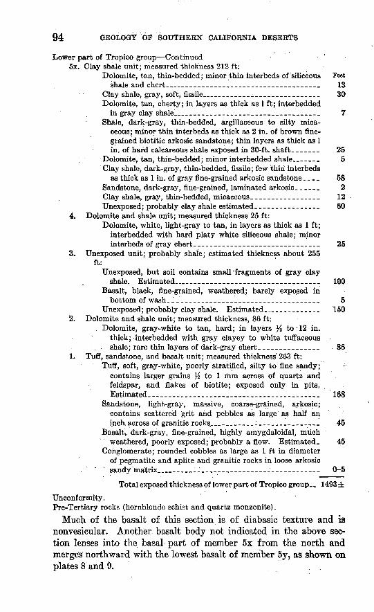
Lower part of Tropico group Continued5x. Clay shale unit; measured thickness 212 ft:
Dolomite, tan, thin-bedded; minor thin interbeds of siliceous Feet shale and chert._________________________________ 13
Clay shale, gray, soft, fissile___________________________ 30Dolomite, tan, cherty; in layers as thick as 1 ft; interbedded
in gray clay shale!__________________________________ 7Shale, dark-gray, thin-bedded, argillaceous to silty mica
ceous; minor thin interbeds as thick as 2 in. of brown fine grained biotitic arkosic sandstone; thin layers as thick as 1 in. of hard calcareous shale exposed in 30-ft. shaft. ______ 25
Dolomite, tan, thin-bedded; minor interbedded shale_______ 5Clay shale, dark-gray, thin-bedded, fissile; few thin interbeds
as thick as 1 in. of gray fine-grained arkosic sandstone. _ _ _ 58Sandstone, dark-gray, fine-grained, laminated arkosic. _____ 2Clay shale, gray, thin-bedded, micaceous__-____-_--______ 12Unexposed; probably clay shale estimated ________________ 60
4. Dolomite and shale unit; measured thickness 25 ft:Dolomite, white, light-gray to tan, in layers as thick as 1 ft;
interbedded with hard platy white siliceous shale; minor interbeds of gray chert-------------.-------.----....-- 25
3. Unexposed unit; probably shale; estimated thickness about 255 ft:
Unexposed, but soil contains small'fragments of gray clay shale. Estimated_______________________ 100
Basalt, black, fine-grained, weathered; barely exposed inbottom of wash________--_________-_____-___--______ 5
Unexposed; probably clay shale. Estimated____________ 1502. Dolomite and shale unit; measured thickness, 86 ft:
, Dolomite, gray-white to tan, hard; in layers >. to'12 in. thick; interbedded with gray clayey to white tuffaceous shale; rare thin layers of dark-gray chert _______________ 86
1. Tuff, sandstone, and basalt unit; measured thickness' 263 ft:Tuff, soft, gray-white, poorly stratified, silty to fine sandy; :
contains larger grains % to 1 mm across of quartz and feldspar, and flakes of biotite; exposed only in pits. Estimated. _______________________________ 168
Sandstone, light-gray, massive, coarse-grained, arkosic; contains scattered grit and pebbles as large as half an inch across of granitic rocks_________________________ 45
Basalt, dark-gray, fine-grained, highly amygdaloidal, much weathered, poorly exposed; probably a flow. Estimated. 45
Conglomerate; rounded cobbles as large as 1 ft in diameter of pegmatite and aplite and granitic rocks in loose arkosic
, sandy'matrix______________________________________ 0-5
Total exposed thickness of lower part of Tropico group. _ 1493 ±
Unconformity.Pre-Tertiary rocks (hornblende schist and quartz monzonite).
Much of the basalt of this section is of diabasic texture and is nonvesicular. Another basalt body not indicated in the above sec tion lenses into the basal part of member 5x from the north and merges northward with the lowest basalt of member 5y, as shown on plates 8 and 9.
ROGERS LAKE AND KRAMER QUADRANGLES 95
The most northwesterly outcrop of the northern Kramer Hills exposure, half a mile southwest of the northeast corner of sec. 33, T. 10 N., R. 6 W., is light-gray massive to bedded tuffaceous sand stone. This sandstone may belong to the lower part of the Tropico group, but more likely it belongs to the upper part, with which its composition and relations are discussed (p. 97).
Near the northwest corner of sec. 10, T. 10 N., R. 6 W., near the east border of the quadrangle and south of U.S. Highway 466, there is a very poor exposure of white fine-grained shaly tuff overlying quartz monzonite. The tuffaceous rock, of which about 12 feet was exposed in a gasline trench, is probably equivalent to unit 1 of the lower part of the Tropico group in the Kramer Hills.
The correspondingly numbered 5 units of the lower part of the Tropico group in each of the 4 stratigraphic sections described above are probably, but not necessarily, time-stratigraphic equivalents. Units designated by the same number in the four sections are of similar lithology but differ in detail.
Figure 4 shows the most probable correlations of the various units of the Tropico group of the Kramer Hills in the 4 sections measured, together with one that lies just beyond the eastern border of the Kramer quadrangle 3 to 5 miles southeast of Kramer Junction. The definite correlations are indicated by solid lines. All others are doubtful.
" Middle part of Tropico group (Red Suites quartz basalt). For the sake of completeness the middle part of the Tropico group (herein called the Red Buttes quartz basalt) is mentioned at this point. However, because of its nature and origin, the quartz basalt is described in detail under "Volcanic rocks" (p. 101-103).
Upper part of Tropico group. The upper part of the Tropico group in the Kramer Hills is composed mainly of weakly resistant clay shale and friable sand that is exposed only in a few places. The most complete section of this part crops out in the southeastern Kramer Hills, in the adjoining Barstow quadrangle, where a thick ness of 804 feet was measured. It is composed mainly of clay shale, some interbedded gray arkosic sandstone, and several thin flows of olivine basalt. Two other small outcrops of the upper part of the Tropico group occur in the Kramer Hills near U.S. Highway 395, and larger exposures occur in the knolls southeast of Kramer Junc tion.
The isolated outcrop in sec. 18, T. 9 N., R. 6 W., on the desert floor west of the southwestern Kramer Hills, exposes about 10 feet of amygdaloidal basalt overlain by about 15 feet of buff fine- to medium-grained bedded arkosic sandstone, and about 3 feet of white medium-grained tuff at the top. The sandstone and tuff, which are

96 GEOLOGY OF SOUTHERN CALIFORNIA DESERTS
C :_T^-
SouthwesternKramer Hills upper part
Sees. 8,16, 17 T. 9 N., R. 6 W.
Tuff
Numbers 1-5 refer to units described in text and shown on plate 9
FIGURE 4. Correlation chart of sections of the Troplco group In Kramer Hills,Calif.
exposed in a shaft, dip southwestward. These beds may belong to the lower part of the Tropico group but are assigned to the upper part because they strike south of the exposures of the southward- dipping Ked Buttes quartz basalt and underlying lower part of the Tropico group.

ROGERS LAKE AND KRAMER QUADRANGLES 97
In the west half of sec. 4, T. 9 N., R. 6 W., in the central Kramer Hills just west of U.S. Highway 395, discontinuous exposures of the upper part of the Tropico group dip to the northwest. The stratigraphically highest part of this section is exposed in a pit. It is composed of gray arkosic pebble conglomerate and coarse sand stone. It is poorly sorted and crossbedded, and dips steeply north westward with about 15 feet exposed in the pit. To the southeast, and stratigraphically lower, are isolated exposures of amygdaloidal basalt that is much weathered, even where exposed in pits. It is probably a flow and is estimated to be about 100 feet thick. This basalt in turn is underlain by about 400 feet of clay shale and minor interbedded sandstones partly exposed in a wash and on a graded surface just west of the highway. The clay shales are soft, greenish gray, silty, and micaceous. The interbedded sandstones are gray, friable, fine grained, and arkosic. These beds are similar to those of the upper part exposed in the southeastern Kramer Hills. The relationship of the upper part of the Tropico group exposed west of the highway to the lower part exposed in the hills to the east is unknown because the contact is concealed. The two parts are probably separated by a fault or perhaps by an unconformity, as units of the lower part strike northwestward, apparently under the upper part that strikes northeastward.
The exposure of the upper part of the Tropico group in the northern Kramer Hills near the center of sec. 33, T. 10 N., R. 6 W., consists of two outcrops of light-gray fine- to medium-grained tuffaceous arkosic sandstone. The sandstone dips very steeply west ward under Quaternary fanglomerate and each outcrop exposes roughly 30 feet of sandstone separated by a concealed gap about 100 feet wide horizontally. The sandstone of the western outcrop is massive, but that in the eastern one is well stratified and dips 80° W. Its structural position and lack of similarity to any sandstone of the lower part indicates that this sandstone belongs to the upper rather than to the lower part of'the Tropico; its relation to the exposures of the lower part and the basalts to the east which dip westward under it is not definitely known because the contact is concealed by alluvium. The attitude of the sandstone suggests that it is stratigraphically higher than the Ked Buttes quartz basalt exposed in the hill to the southeast, for the basalt probably strikes north ward toward and may pinch out under the concealed gap between the sandstone and the lower part of the Tropico group.
In the low knolls in sees. 16,17, 21, and 22, T. 10 N., R. 6 W., east of U.S. Highway 395 and 2 to 4 miles southeast of Kramer Junc tion, are isolated outcrops of Tertiary sediments that dip generally 30° SW. These strata are tentatively assigned to the upper part of
98 GEOLOGY OF SOUTHERN CALIFORNIA DESERTS
the Tropico group because they overlie the lower part and. the intercalated basalt flows that crop out to the southeast in sees. 22, 23, and 24, T. 10 N., R. 6 W., just beyond the eastern border of the Kramer quadrangle. However, these beds assigned to the upper part may belong to the top of the lower part.
The knolls within half a mile east of U.S. Highway 395, in sees. 16 and 17, T. 10 N., R. 6 W., expose a partial section of the south ward-dipping upper part of the Tropico group. The probable thickness of this incompletely exposed section, from the strati- graphically lowest to highest exposed beds, is estimated to be about 800 feet. The lowest 400-f- feet of beds exposed consist of buff to white friable fine- to medium-grained sandstones and some inter- bedded gray micaceous siltstone. This unit is overlain by a lens, possibly 150 feet in maximum thickness, of granitic and dioritic breccia. The breccia in turn is overlain by about 150 feet of gray argillaceous shale and minor thin interbeds of fine-grained arkosic sandstone. The shale is exposed on the highway and contains sev eral layers % to 4 inches thick of fine white volcanic ash. A gap separates the shale from the highest bed exposed to the south which consists of fine-grained arkosic sandstone.
The upper part of the Tropico group again crops out to the south east in sees. 21 and 22, a mile east of the highway. This section is generally the same as that described above but differs in detail. It is underlain by the lower part that crops out just beyond the eastern border of the mapped area.
Incompletely exposed section of upper part of the Tropico group 3 to 4 miles south east of Kramer Junction, in sees. 21, 22, T. 10 N., R. 6 W.
Fanglomerate (Pleistocene?).Angular unconformity. -F6^Upper part of Tropico group: mated)
f. Sandstone, light-gray, massive to bedded, medium- to fine grained, arkosic; grades downward into next unit______________ 150
e. Siltstone, gray, sandy, poorly bedded._________________________ 100d. Chert, opaque gray-white to translucent gray, hard, massive;
locally streaked with ocher yellow, brown, red, and black; in places contains silicified roots of reeds, palms (?), and other plants__________----- _--_ _ _-_ 2-7
c. Shale, gray, massive, argillaceous to sandy, poorly exposed; con tains several 6-in. to 1-ft layers of dolomite in northwestern- most exposure___--__---_----------------------_----------- 75
b. Breccia, granitic; composed of angular blocks as large as 20 ft ofbiotite quartz monzonite-____-_-_-----_-_-_---_--_-__----_ 50-150
a. Sandstone, light-gray, bedded, friable, fine- to medium-grained, arkosic; exposed mostly beyond eastern border of Kramer quadrangle _______________-__--_-___-_-___--___--_________ 100
Total thickness of upper part of Tropico group______________ 580±
Lower part of Tropico group (350 ± feet of basalt at top) exposed east of map area.

ROGERS LAKE AND KRAMER QUADRANGLES 99
The granitic breccia of this section is probably correlative with that exposed to the northwest at .and near U.S. Highway 395. Both appear to be landslide breccias from an unknown local source.
- Within 2 miles southeast of Kramer Junction are 2 small isolated outcrops of the Tropico group, probably the upper part. The one that is near the southwest corner of sec. 9, T. 10 N., R. 6 W., exposes about 30 feet of buff fine- to medium-grained arkosic sandstone that dips 35°. N. The other, which is near the center of sec. 8, T. 10 N., R. 6 W., exposes basalt that weathers soft and is overlain by about 5 feet of white to tan ferruginous limestone or dolomite.
The alluviated valley area between the Kramer Hills and the low knolls southeast of Kramer Junction is probably underlain by a considerable thickness of the Tropico group, as indicated in a test hole drilled in sec. 20, T. 10 N., R. 6 W., the log of which is summarized on p. 135. The section penetrated from 1,150 feet to bottom at 3,500 feet was ajl gray arkosic sandstone and subordinate interbeds of gray siltstone, clay shale, and pebbly sandstone of the Tropico group. All this section is either the upper part of the Tropico group or a sandy f acies of both the upper and lower parts.
VOLCANIC ROCKS
Dacite. Haystack Butte, a prominent double-cone-shaped feature that rises more than 400 feet above the adjacent area of low relief, is formed of dacite. The butte is presumed to be a volcanic neck, but it is surrounded by a mantle of windblown sand that conceals the contact with the adjacent quartz monzonite.
The dacite is probably of Tertiary age and perhaps was em- placed during the interval in which dacite vitrophyre was emplaced or extruded in the Kramer Hills.
The dacite of Haystack Butte is light greenish brown and weathers somewhat lighter. The rock is hard, unweathered, and massive, with no discernible flow laminae. It is slightly porphyritic, with a fine grained holocrystalline groundmass and scattered small phenocrysts 1 mm or less across that make up about 20 percent of the total rock mass. Under the microscope the major constituents are identified as plagioclase (oligoclase), quartz, and biotite, and the minor con stituents as hematite, an unidentified opaque mineral, hornblende, and potassium feldspar, in that order of abundance. The feldspars occur as anhedral grains and euhedral phenocrysts, quartz as an- hedral grains and phenocrysts, biotite as euhedral tablets as large as 1 mm across, and hornblende in thin blades as long as 2 mm.
Dacite vitrophyre of Tropico group. Dacite vitrophyre crops out in the central Kramer Hills at the east border of the Kramer quad rangle in the Sl/2 sec. 3, T. 9 N., R. 6 W. Part of the outcrop that lies within the adjoining Barstow quadrangle was described as
100 GEOLOG* OF SOUTHERN CALIFORNIA DESERTS
biotite dacite vitiophyre by Bowen (1954, p. 77 j fig. 47^t). The dacite-vitrophyre stands out as a conspicuous lens as much as 150 feet wide and nearly half a mile long and forms a prominent north westward-trending strike ridge. On weathering the rock breaks into large irregular fragments.
The dacite vitrophyre occurs within southwestward-dipping fri able arkosic sandstone and conglomerate of the lower part of the Tropico group and is indicated as unit Ib of the central Kramer Hills section. These beds are poorly exposed and all contacts with the vitrophyre are covered by its own talus, so that the field rela tions are uncertain. However, flow banding in the vitrophyre trends parallel to the strike and dips steeply south west ward. This con formity to the general steep southwesterly dip of the Tropico group in these hills indicates that the vitrophyre is probably an extrusive lens within the Tropico group, though it may be an intrusive sill- like pod. .
The dacite vitrophyre is medium gray and glassy; it weathers brown gray. The rock is not weathered except on exposed surfaces. It is massive to coarsely flow laminated and tends to fracture along the laminae where present. The gray glassy groundmass contains small phenocrysts that make up 10 to 20 percent of the total rock mass. The phenocrysts consist of abundant fresh euhedral biotite tablets 1 mm or less across, subhedral nearly clear plagioclase (sodic andesine) 1 mm or less long, and anhedral quartz ^ to 1 mm across. Examination in thin section shows that the plagioclase phenocrysts are numerous and of different sizes and that some are zoned (Bowen, 1954, fig. 47A).
Basalt of Tropico group. In the Kramer Hills, basalt occurs as tabular bodies intercalated between lake beds of the Tropico group. The areal distribution of these basalt bodies is shown on plates 8 and 9, and their stratigraphic position and thicknesses are shown in figure 4. The basalt occurs mostly as lava flows, but some may be sills intrusive along bedding planes. In the Kramer Hills beyond the east border of the Kramer quadrangle. are several basaltic out crops described as olivine analcite diabase by Bowen (1954, p. 85, fig. 465). The only occurrence of basalt outside the Kramer Hills is the small outcrop at the base of the Tropico group near the north west corner of the Rogers Lake quadrangle.
At most places the basalt is highly weathered by mechanical sepa ration of grains so that exposures are conspicuous only by their color dark brown or dark greenish brown to gray. The fresh rock is nearly black, moderately hard, massive, and of fine- to medium- grained diabasic texture. Some bodies, notably the small basal one in the northern Kramer Hills and the small one in the southwestern
ROGERS LAKE AND KRAMER QUADRANGLES 101
Kramer Hills, are highly amygdaloidal; the large bodies in the northern and central Kramer Hills contain few amygdules. The amygdules are generally spherical and range from 1 to 8 mm across. Most of them, probably originally zeolites, have been leached out and partly replaced by calcite, chalcedony, or quartz, or by a soft ocherlike material.
The larger basalt layers in the Kramer Hills are olivine-bearing. The minerals readily identified with the aid of a hand lens are plagioclase, augite, olivine (partly altered), and iron oxides. Under the microscope the rock of the larger bodies is seen to consist of plagioclase (labradorite), 40-50 percent; augite, 25-30 percent; olivine (partly altered to iddingsite and antigorite?), 10-15 per cent; magnetite and ilmenite, %-A percent. In addition there are variable amounts of secondary minerals such as chlorite, hematite, limonite, calcite, and chalcedony. The plagioclase occurs as laths as long as 1 mm. The augite and olivine occur as subhedral crystals. Bowen (1954, p. 85, fig. 46Z?) reported the presence, in the olivine basalt exposed in the eastern Kramer Hills, of analcite, ilmenite, and natrolite, all totaling less than 10 percent of the rock mass.
The small flow of amygdaloidal basalt at the base of the Tropico group in the northern Kramer Hills section contains no olivine. Under the microscope the rock is seen to consist mainly of zoned plagioclase (calcic andesine to sodic labradorite), much hematite and glass (partly devitrified), and abundant secondary calcite. The amygdules, which are from 2 to 5 mm across, are composed of cal cite and a soft yellow ocherlike material, probably an alteration product of a zeolite.
Red Buttes quarts basalt of Tropico group. A distinctive dark- colored largely extrusive quartz basalt crops out prominently as dis continuous exposures in the Kramer Hills and at Ked Buttes in the eastern part of the Kramer quadrangle. In the Kramer Hills be yond the east border of the quadrangle there is a continuous 6-mile- long exposure that was described as quartz andesite by Bowen (1954, p. 84-85). This flow rock was named the Red Buttes quartz basalt because of its prominence at Red Buttes, which is designated as the type locality (Dibblee, 1958, p. 142).
This basalt occupies a stratigraphic position similar to the Sad dleback basalt in the Kramer borate district (Gale, 1946, p. 346-347) and the two units may be correlative. The Red Buttes quartz basalt is highly resistant to weathering and erosion. However, it is closely jointed, so that it fractures into rather small angular blocks or slabs and tends to form somewhat gentle slopes strewn with loose fragments.
648598 61 5

102 GEOLOGY OF SOUTHERN CALIFORNIA DESERTS
At Red Buttes the quartz basalt comprises several lava flows that total about 300 feet in maximum thickness, dip southeastward, and rest on quartz monzonite. On the southeast the quartz basalt is overlain unconformably by Quaternary fanglomerate and alluvium. No feeder dikes or plugs have been definitely identified in this vol canic mass, though it may in part be intrusive. The Red Buttes quartz basalt exposed in the hills north of Red Buttes probably represents erosional remnants of a nearly flat-lying extrusive mass of this rock resting on quartz monzonite and on the basal beds of the Tropico group.
In the southwestern Kramer Hills west of U.S. Highway 395 in and near sec. 16, T. 9 N., R. 6 W., the Red Buttes quartz basalt occurs as an extrusive mass about 200 feet thick resting on the clay shale unit of the lower part of the Tropico group, probably with a slight angular unconformity. At this exposure the quartz basalt forms a prominent southwestward-facing dip slope and passes under Quaternary alluvium to the southwest.
In the central and northern Kramer Hills the quartz basalt crops out as a thin flow that rests with possible unconformity on the lower part of the Tropico group and associated olivine basalts and is unconformably overlain by Quaternary fanglomerate. At its northern and western limits in the northern Kramer Hills the quartz basalt is probably not more than 20 feet thick; it lies upon more steeply dipping lake beds and flows of olivine basalt and appears to dip gently westward.
The apparent lower dip of the basal contact of the quartz basalt as compared to the dip of the underlying lower part of the Tropico group in all sections and the eastward overlap of the clay shale unit of these beds in the southeastern Kramer Hills southeast of the Ball-Kramer magnesite pit are evidence of the unconformable re lation. The occurrences of the quartz basalt on the basal beds of the Tropico group at the hill 2 miles northeast of Red Buttes and directly on quartz monzonite at and near Red Buttes suggest a southwestward overlap from the Kramer Hills and are further evi dence of the unconformable relation.
The Red Buttes quartz basalt is dense and black when fresh but weathers to various shades of steel gray, brown, and maroon red on exposed surfaces. The rock is massive with no discernible flow laminae; in many places platy fractures parallel to the top and base of flows give the appearance of rude layering. In a few places the rock is weakly to moderately brecciated.
The texture is extremely fine, and the rock contains scattered rounded quartz phenocrysts 1 mm or less in diameter. In some localities small euhedral phenocrysts of plagioclase less than half a
ROGERS LAKE AND KRAMER QUADRANGLES 103
millimeter across are also barely discernible with the aid of a hand lens. Phenocrysts make up less than 15 percent of the rock mass. Small rust-colored scattered flecks are probably alteration products of pyroxene or hornblende. The rock is generally not amygdaloidal, although some flows locally contain spherical vugs.
The petrography of the Ked Buttes quartz basalt was described in detail by Bowen (1954, p. 83-84, fig. 46.A), from whose report the following description is taken. In thin section most specimens are found to contain 75-85 percent crystalline material and 25-15 percent glass. Bounded embayed quartz phenocrysts make up 5-10 percent of the rock. These commonly are surrounded by a corona of small crystals of augite-diopside. Phenocrysts of zoned plagio- clase (labradorite) are abundant but much smaller than the quartz phenocrysts and vary greatly in quantity and size. The most abun dant groundmass minerals are unzoned labradorite (An60.63) and a colorless clinopyroxene intermediate in composition between augite and diopside. Hypersthene, greenish-brown hornblende, and mag netite are also present in appreciable amounts. Hypersthene is com monly rimmed by augite-diopside that replaces it. Secondary magnetite commonly rims hornblende and pyroxenes. A brownish- yellow chloritelike mineral, probably nontronite, is present in some slides as irregular groundmass patches. Also seen in some slides are patches of mixed fine-grained carbonate minerals and serpentine or chloritic material, probably secondary after pyroxene. The min eral content of the rock varies within the following estimated limits: labradorite, 35-40 percent; augite-diopside, 20-35 percent; quartz, 5-15 percent; hypersthene, 5-10 percent; hornblende, 2-3 percent; magnetite, 2-3 percent; nontronite(?), 0-1 percent; glass, 15-25 percent.
POSSIBLE RELATIONS OF BISSELL HILLS AND KRAMER HILLS EXPOSURES
As stated on page 87, the exposures of the Tropico group in the Bissell Hills and the Kramer Hills are many miles apart and their stratigraphic sequences differ; hence, their age relations are uncer tain. For that reason, details about the group were presented separately for the two areas. With those details in mind, possible correlation of the units of the group between the two areas is now briefly discussed.
The tuff of unit 1 (the basal unit) of the lower part of the Tropico group in the Kramer Hills is similar to the Gem Hill formation (the lower formation of the group) in the western part of the Bissell Hills west of the Rogers Lake quadrangle. Furthermore, both sequences contain some granitic sandstone and conglomerate, though the proportion in the Gem Hill formation is much smaller.

104 GEOLOGY OF SOUTHERN CALIFORNIA DESERTS
If the equivalence thus suggested is valid, then unit 1 in the Kramer Hills is of probable middle Miocene age, for the Gem Hill forma tion in the adjoining Rosamond quadrangle was correlated by the writer (Dibblee, 1958, p. 140), on the basis of similar lithology and stratigraphic position, with the Kinnick formation of Buwalda and Lewis (1954, p. 147-148), which yielded a middle Miocene ver tebrate fauna.
Relations between units 2 and 3 in the Kramer Hills and the Tropico group in the Bissell Hills are somewhat more contradictory and uncertain. On the one hand, the presence of tuffaceous ma terial in unit 3 suggests that this unit, together with units 1 and 2, is a stratigraphic equivalent of the Gem Hill formation. On the other hand, the presence of carbonate rocks and tuffaceous or sili ceous shales in unit 2 suggests that this unit, together with units 3 and 4, is a stratigraphic equivalent of the carbonate and shale of the Bissell formation. Unfortunately this apparent inconsistency is not clarified in the succeeding units. The dolomite and shale unit (4) is lithologically very similar to the carbonate and shale of the Bissell formation and is therefore probably but not neces sarily equivalent to it; the clay shale unit (5) is lithologically similar to the clay member that overlies the carbonate and shale of the Bissell formation.
The age within the Tertiary of the Bissell formation in the Bissell Hills and of its probable equivalent units of the lower part of the Tropico group in the Kramer Hills is unknown. However, com parison with rocks in several outside areas (Dibblee, 1958, p. 136- 143) indicates that these units are probably of upper Miocene or lower Pliocene age.
The age of the Red Buttes quartz basalt and overlying upper part of the Tropico group in the Kramer Hills is unknown, except that it is younger than that of the lower part which is either of middle or upper Miocene or of lower Pliocene age. The duration of the interval of disturbance and nondeposition represented by the unconformity between the lower part and the Red Buttes quartz basalt is also unknown, but the unconformable relation suggests that the basalt and the beds above the unconformity are more likely of Pliocene than of Miocene age.
QUATERNARY ROCKS
FANGLOMERATE
The fanglomerate is a widespread, weakly consolidated accumu lation of unsorted fragments, cobbles, and boulders in a sandy matrix and is generally not stratified. The fragments that make up the fanglomerate are angular to rounded, more commonly sub-

ROGERS LAKE AND KRAMER QUADRANGLES 105
rounded, and are of all sizes, the largest as much as 5 feet in longest dimension. Most of the fragments are quartz monzonite like that exposed throughout much of the mapped area. Fragments of granite, pegmatite, aplite, metavolcanic rocks, and, in a few places, Tertiary volcanic and hard sedimentary rocks are less abun dant. Many of the quartz monzonite fragments, even the largest ones, are incoherent and friable, and some can be easily crushed by hand. Others, as well as those of granite, pegmatite, and aplite, are coherent and hard. These rocks are embedded in a light-gray weakly consolidated matrix of gritty medium- to coarse-grained arkosic sandstone, which is composed of poorly sorted fine to coarse angular grains of feldspar and quartz, flakes of biotite, and granitic grit. The porosity of the fanglomerate is low.
In a few places the fanglomerate contains lenticular layers of coarse gritty arkosic sandstone a few feet thick and traceable for not over 50 feet. Most of the sandstone is soft and friable but some is hard and calcareous. Caliche-cemented sandstone and conglom erate also occur locally but are uncommon or rare in the outcrop areas.
In the cored section in the test hole 3 miles south of Kramer Junction the arkosic matrix of the fanglomerate is moderately in durated. However, in areas where the fanglomerate is exposed to erosion the matrix disintegrates into its constituent grains and into fragments that are readily washed away, leaving the larger frag ments strewn loose on the ground. The resulting subdued topog raphy differs from that formed by exposures of quartz monzonite in that the ground surface underlain by fanglomerate is strewn with boulders.
An undulating erosion surface has been cut on nearly all exposures of the fanglomerate. This surface distinguishes the fanglomerate in the field from the younger Pleistocene gravel and sand mapped as older alluvium, on which the surface of deposition is usually pre served though dissected.
The thickness of the fanglomerate ranges, within short distances, from a thin wedge to a known maximum of 1,100 feet.
The fanglomerate was deposited during and after a period of regional uplift, deformation, and erosion that affected a large part of the western Mojave Desert following deposition of the Tertiary formations. The fanglomerate was probably derived from the higher parts of this uplifted region; it was deposited as alluvial fans on an erosion surface of low relief cut on the marginal parts of the uplifted region and in small valleys carved within it. The poor sorting of the erosional debris and the large sizes of boulders that make up the fanglomerate indicate that the highland source areas

106 GEOLOGY OF SOUTHERN CALIFORNIA DESERTS
were rugged and were drained by intermittent streams of high competency.
The fanglomerate is thickest and most extensively exposed in the Kramer Hills, where it is locally deformed and thoroughly dis sected. Near U.S. Highway 395 it is tilted westward, as indicated by barely discernible stratification and by several dips as much as 20° W. measured in lenses of coarse arkosic sandstone. The thick ness of the fanglomerate in this exposure is at least 500 and possibly as much as 1,000 feet. The contact with the underlying Tertiary beds of the Tropico group to the east is concealed or poorly exposed, but these beds all dip steeply westward, a dip of 80° having been measured in Tertiary sandstone near the contact. This steep dip indicates an angular discordance of about 60° between the Quater nary fanglomerate and the underlying Tropico group at that lo cality. The basal layer of fanglomerate at this contact is composed of angular fragments derived from basalt of the underlying Ter tiary rocks. Above the basal layer the fanglomerate contains, in addition to the usual granitic fragments, scattered fragments of pre-Tertiary meta-andesite and quartz latite and of Tertiary basalt, chert, and carbonate rocks that decrease upward in the section.
In the Kramer Hills west of U.S. Highway 395 the fanglomerate appears to be flat lying or nearly so, and 2 to 4 miles west of the highway it rests directly on an undulating surface cut on the quartz monzonite. In the hills 2 miles south-southwest of Kramer, layers of boulders and of clay in the fanglomerate suggest that it dips southwestward into the quartz monzonite. The dip also is apparent on aerial photographs, but there is no evidence of faulting at the contact. The fanglomerate of these areas is composed almost en tirely of granitic detritus.
The valley area north of the Kramer Hills is probably underlain by fanglomerate that is largely concealed by Eecent alluvium but that crops out in the low hills east of U.S. Highway 395. In these hills the fanglomerate probably dips gently southwestward and rests unconformably on Tertiary formations dipping about 30° SW.; east-southeast of Kramer Junction, it rests directly on quartz mon zonite. The basal part of the fanglomerate in these exposures con tains an abundance of fragments of Tertiary basaltic volcanic rocks, as it does in those in the Kramer Hills to the south. The thickness and character of the fanglomerate are best determined from a test hole drilled 3 miles south of Kramer Junction. This core hole, whose log is summarized on page 135, penetrated granitic fanglome rate from 100 to 1,151 feet. Cores of this fanglomerate show that it is of the same lithology as that exposed in the Kramer Hills, although the arkosic matrix is light greenish gray and moderately well in durated.
ROGERS LAKE AND KRAMER QUADRANGLES 107
Another test hole (p. 135), drilled 5 miles west of Boron, penetrated cobble gravel from 1,202 to 1,672 feet, which, in the writer's opinion, may be equivalent to the fanglomerate of the Kramer Hills. This gravel is so weakly consolidated that the core barrel recovered only rounded cobbles of granitic rocks and dark-brown porphyritic vol canic rocks, probably Tertiary mafic andesite.
At Ked Buttes the fanglomerate is probably several hundred feet thick and appears to dip gently into the valley to the east. At the eastern base of Ked Buttes the fanglomerate is brown and is com posed entirely of dark quartz basalt rubble derived from the Ked Buttes quartz basalt upon which it lies unconformably. In the large exposures south of Ked Buttes the fanglomerate is light gray and is composed of granitic detritus derived from the underlying quartz monzonite to the west.
The fanglomerate exposed in the vicinity of the Kern-Los Angeles County line southwest of Haystack Butte differs from that exposed in the Kramer Hills area in that it is composed of many rock types. The fragments are mostly of cobble size and are moderately to well rounded. They are composed of quartz monzonite, granite, pegma tite, aplite, metavolcanic rocks, and Tertiary andesitic and rhyolitic volcanic rocks. In some places more than 50 percent of the frag ments are of Tertiary volcanic rocks, mostly brown to pink massive to banded andesitic and dacitic rocks. The fragments are set in a loose light-gray massive coarse sandy matrix. The formation is devoid of bedding, but an estimated thickness of about 200 feet is exposed. It rests directly on quartz monzonite, and its base dips gently northwestward toward Antelope Valley.
On Jackrabbit Hill 5 miles west-southwest of Haystack Butte, the fanglomerate is composed of well-rounded and polished cobbles mostly of quartzite and of light- to dark-gray meta-andesitic por phyry set in a poorly indurated brown massive sandy matrix. This deposit is the only exposure of supposed Quaternary fanglomerate gravel in which the cobbles are so well rounded and polished, and it may belong to an older formation of possible Tertiary age. The fanglomerate has no discernible bedding, but its thickness is prob ably at least the height of the hill which it forms that is, about 200 feet. The gravel rests directly on quartz monzonite.
In the Bissell Hills fanglomerate occurs as an erosional remnant and is roughly about 200 feet in maximum thickness. It rests un conformably on a nearly beveled surface of quartz monzonite and synclinally folded strata of the Tropico group. As in the Kramer Hills, it is composed almost entirely of unsorted granitic detritus in a weakly consolidated arkosic matrix, with boulders as large as 2 feet in diameter.

108 GEOLOGY OF SOUTHERN CALIFORNIA DESERTS
At the north edge of Buckhorn Lake are two isolated outcrops of granitic f anglomerate like that exposed in the Bissell Hills. Both outcrops are surrounded by Recent alluvial sediments, so that the relation of the f anglomerate to adjacent formations is not definitely known. It probably rests unconf ormably on quartz monzonite which crops out a mile and a half north, although under Antelope Valley it may rest on Tertiary formations.
The age of the fanglomerate can be determined only from its stratigraphic relations. The regional angular unconformity that separates it from the underlying Tropico group, of which the young est part is of probable Pliocene age, indicates that the fanglomerate is most likely of Pleistocene age, although the possibility that it may be in part of late Tertiary age cannot be ruled out. The upper age limit is that of the older alluvium, which is of probable late Pleistocene age and overlies it in places unconf ormably.
OLDER ALLUVIUM
The older alluvium is a thin deposit of undeformed loosely con solidated gravel and sand. In places it rests on a beveled surface cut on or into the fanglomerate as well as on older formations; it is overlain by younger or Recent alluvium.
Within the mapped area only the upper part of the older alluvium is dissected and exposed. The most prominent outcrops are those along the northern fringe of the Shadow Mountains, where dis secting washes and gullies expose as much as 150 feet of older alluvium. It is here composed of weakly consolidated cobble gravel and pebbly sand; some layers of the gravel and sand are firmly cemented with white calcareous caliche. The fragments are sub- angular to angular, are as large as 2 feet in longest dimension, and are derived from metamorphic and granitic rocks exposed in the Shadow Mountains.
Near Red Buttes the older alluvium is composed mainly of loosely consolidated granitic sand with local admixtures of fragments of Red Buttes quartz basalt. It is readily distinguishable from the fanglomerate by the lack of large boulders and by the preservation of its surface of deposition. The older alluvium thins out against the hills to the west and north and against the Shadow Mountains to the south, and probably thickens to several hundred feet in the valley area to the east.
In the foothill area south of Boron the older alluvium consists of unconsolidated granitic sand derived from the quartz monzonite to the south. The older alluvium thins out to the south against granitic bedrock, and in the valley area to the north and west it may thicken to several hundred feet. In the test hole 5 miles west

ROGERS LAKE AND KRAMER QUADRANGLES 109
of Boron, older valley alluvium composed of weakly indurated massive tan sand and silt and some caliche layers was found from about 100 to 1,202 feet, below younger valley alluvial soil and above cobble gravel and sand.
In Antelope Valley the older alluvium no doubt underlies the Recent alluvium and probably overlies or grades into the Quaternary f anglomerate, but no wells have been drilled in the older alluvium within the Rogers Lake quadrangle to determine its limits.
ALLUVIUM
Undissected, undeformed alluvium of Recent age fills all valley areas and flood plains of washes throughout the mapped quadran gles. The most extensive deposits are in Antelope Valley and in the valley areas of Kramer Junction and east and north of Red Buttes.
In the valley areas the Recent alluvium is several hundred feet thick, but the exact thickness can not be determined in well logs because the material is not differentiate from the older or Pleistocene alluvium. In the test hole 5 miles west of Boron, however, Recent alluvial sand was drilled to a depth of at least 100 feet. Clay, silt, and sand cored from 100 to 536 feet is presumably Pleistocene older alluvium, but may in part be Recent alluvium. Along the margins of the valley areas the alluvium thins out upslope against older for mations.
The Recent alluvium is divisible into five mappable facies based on modes of deposition and lithology. All are contemporaneous and grade laterally into each other. These are alluvial gravel and sand, playa clay, windblown sand, playa clay and windblown sand, and bars of wave-deposited sand.
Alluvial gravel and sand. Most of the alluvium is stream laid and is composed of gravel, sand, silt, and mixtures of weathered soil. There are two types of stream-laid alluvium: fan alluvium and valley alluvium. However, there are all gradations between coarse fan alluvium and fine valley alluvium and they cannot be differentiated except locally in Antelope Valley south of Rogers Lake.
Deposits of fan alluvium fringe the hill areas as broad piedmont or apron alluvial fans with surfaces that slope into the valleys from about 80 to 200 feet per mile. In all these deposits the fan alluvium grades imperceptibly downslope into the finer valley alluvium. The steepest and most prominent of these apron fans is that along the northwestern margin of the granitic hills southeast of Rogers Lake; it extends from the edge of the nearly level part of Antelope Valley into reentrants far up the slope of these hills. This apron fan

110 GEOLOGY OF SOUTHERN CALIFORNIA DESERTS
probably extends northeastward along the west slope of the hills east of Rogers Lake where the fan broadens and flattens and is cov ered by a thin veneer of windblown sand. The maximum thickness of this apron fan is probably several hundred feet, possibly as much as 500 feet.
The fan alluvium is composed almost entirely of coarse- to medium- grained light-gray granitic.sand derived from rocks exposed on the hills. Some gravel and fanglomerate are present in fans such as those that fringe the Kramer Hills, Bed Buttes, and the Shadow Mountains, where the alluvium was partly derived from the Qua ternary fanglomerate, Tertiary formations, and pre-Tertiary meta- morphic rocks. The coarse grains and fragments are embedded in a weathered sandy soil matrix, especially in the downslope parts of the fans.
The valley alluvium is composed of fine-grained unconsolidated gray weathered soil (loam) and mixtures of gray-tan poorly sorted sand, silt, and clay. It fills the nearly level areas such as Antelope Valley and parts of the smaller valleys in the Kramer quadrangle. In Antelope Valley the surface of the alluvium slopes about 20 feet per mile; in the small valleys in the Kramer quadrangle it slopes about 35 feet per mile. This is in marked contrast to the slope of 80-200 feet per mile of the surface of the alluvial fan deposits, and on the map (pi. 8) the valley alluvium and fan alluvium can usually be distinguished by this difference in slope.
Playa clay. Playa clay is the fine playa or mud-flat facies of the Recent alluvium; it fills the playas of Rogers Lake and Buckhorn Lake, the numerous smaller playas in Antelope Valley, and a small playa 3 miles northeast of Haystack Butte. The most extensive deposit of playa clay underlies Rogers Lake, which covers an area of about 44 square miles. The surface of the clay is level, smooth, and devoid of vegetation.
The playa facies of the alluvium is composed of light-gray to gray-tan massive argillaceous to silty clay and micaceous silt. The clay and silt are soft and pliable when wet but quite hard when dry. Only a minor amount of alkali occurs in the clay and silt, mostly in the form of chlorides, carbonates, and sulfates of sodium and potassium. The thickness of the playa clay is not definitely known, for few wells have been drilled in the playas. The thickness no doubt varies; it may be as much as 100 feet. The blue clay found down to 400 feet in some wells in Antelope Valley south of Rosa mond and Buckhorn Lakes (Thompson, 1929, p. 306) may be part of the playa-clay facies; if so, it extends southward into or under the valley-fill alluvium.
Windblown sand. The windblown-sand facies of the Recent allu vium is widely distributed throughout the mapped area. This facies

ROGERS LAKE AND KRAMER QUADRANGLES 111
consists of buff loose well-sorted fine-grained sand composed of subrounded grains of quartz and feldspar. The sand was blown and deposited by the frequent westerly gales that blow across the area during the winter and spring.
In Antelope Valley windblown sand occurs as numerous dunes around and near Buckhorn Lake and the associated playas and along the eastern margin of Rogers Lake. The sand of these de posits is loose, clean, fine grained, and well sorted, and is practically devoid of any vegetation cover.
Five playas north of Buckhorn Lake are fringed by crescent- shaped dune ridges of sand 30 to 60 feet high. All are concave westward toward the direction of the prevailing wind and have long gentle slopes facing westward and steeper slopes facing eastward. Dunes south of Buckhorn Lake are of less regular shape, although some are low ridges trending eastward. Several eastward-trending sand ridges occur at the south end of Rogers Lake. The numerous dunes along the east margin of this lake are ridges of various shapes, some trending eastward, others northward; a few are crescent-shaped like the large ones near Buckhorn Lake. At the northeast end of Rogers Lake are large dune ridges as high as 50 feet. Some are crescent-shaped and V-shaped and are concave west ward like those at Buckhorn Lake. While sand dunes in other desert regions generally are convex rather than concave toward the direction from which the prevailing wind blows, in this area the windward concavity is the effect of sand accumulating at the lee ward margins of playas to form long ridges of sand that rim them, as shown on plate 8.
Crossbedding that dips in generally easterly directions at angles as much as 35° is conspicuous in the sand of many of the crescent dunes and in the northward-trending dune ridges. These eastward- dipping crossbeds probably represent sand that was blown off the windward west slopes and dropped on the steep leeward east slopes by the prevailing west wind. The eastward-dipping crossbeds indi cate that the dunes have been moving slowly toward the east as they are being worn away on the windward side and built up on the leeward side. The dunes are probably built up on a platform of ,playa clay or valley alluvium, and, if so, the sand does not extend more than a few feet below the base level of the playa or valley surface.
Windblown sand also occurs as thin extensive veneers of more or less uniform thickness covering stream-laid alluvium or older for mations. The most extensive sheet of windblown sand is that which covers the broad westward-facing slope between Rogers Lake and the highlands to the east, as shown on plate 8. This sheet of sand

112 GEOLOGY OF SOUTHERN CALIFORNIA DESERTS
is thin, in most places probably not more than 50 feet. It covers fan alluvium on the lower slopes, granitic bedrock and Quaternary fanglomerate on the upper slopes. The deposit extends from the dunes along the east margin of Rogers Lake eastward over the top of the highlands near Haystack Butte and surrounds the butte itself; it is composed of the same type of sand as that which forms the dunes and piles in Antelope Valley, except that on the upper slopes there are local admixtures of granitic grit derived either from the underlying bedrock or from fan alluvium. The sand is either mas sive or bedded and is tan to brown. About 4 miles south of Boron are deposits and eastward-trending ridges of clean loose sand on granitic bedrock and fan alluvium.
Other sheets of sand, of smaller areal extent, occur on the south west margin of the Kramer Hills and at the southwest base of the hills north of Edwards.
The sheets of windblown sand are nearly everywhere covered by a moderate growth of brush, bunch grass, and Joshua trees.
Playa clay and windblown sand. Along the marginal parts of Rogers and Buckhorn Lakes and in Antelope Valley to the south are numerous little playas separated by piles a few feet high of windblown sand. It was impractical to differentiate the clay and sand on plate 8, so they are shown together as a unit. The piles of sand were probably deposited on a platform of playa clay and silt or valley alluvium, and upslope from 2,325-foot contour on valley alluvium.
Wave-deposited bars. Shoreline bars of gravel, sand, and silt occur locally along the margins of Rogers Lake. The most promi nent is the one around the northern part of the playa that extends from the granitic hills in sec. 24, T. 10 N., R. 9 W., northwestward and then southward to Edwards to form an arc with a radius of nearly 3 miles. This bar is about a quarter of a mile wide and 10 to 25 feet high, and its base is near the 2,300-foot contour. In the western part the base is somewhat higher than in the eastern part. The bar is composed mainly of interbedded tan to light-gray coarse sand and of pebble gravel with clay balls.
Three miles south of Edwards a mile-long bar about 20 feet high connects 2 isolated hills of granitic bedrock, and another small bar projects from the northeast end of the northeast hill. Both bars are near the 2,300-foot contour. A cross section of the connecting bar is partly exposed in the highway cut of 120th Street East. The bar is composed of interbedded tan to light-gray coarse sand, silt, and subrounded granitic pebbles and clay balls. The deposit is conspicu ously bedded and in part crossbedded.

ROGERS LAKE AND KRAMER QUADRANGLES 113
Remnants of mud and silt bars are locally present against the granitic exposures of the hills on the east side of northern Rogers Lake at and below the 2,300-foot contour. The bars also contain granitic pebbles and clay balls. Remnants of a higher bar are found at or near the 2,330-foot contour.
The bars of gravel, sand, and silt were deposited by wave action along the shores of Rogers Lake when it was filled with water to about 2,300-foot contour or to a depth of about 30 feet. The clay balls were apparently formed from pieces of lake-bottom clay that were rolled by the waves.
STRUCTURE
Structural features now seen within the Rogers Lake and Kramer quadrangles reflect two upsurges of crustal deformation and igneous activity. First, the pre-Tertiary sedimentary and volcanic rocks of the western Mojave Desert region were severely deformed, meta morphosed at depth, and later invaded by widespread batholithic igneous rocks, probably during Late Jurassic and Early Cretaceous time. The second deformation began during the Cenozoic era and is still continuing; it has resulted in broad warping movements of the crystalline basement, accompanied and followed by faulting.
METAMORPHIC BOCKS
Within the mapped area the metamorphic rocks that reflect the earlier upsurge are restricted to a few small exposures.
The rocks of the Oro Grande(?) series of Hershey (1902), in the southeast edge of the Kramer quadrangle dip southeastward, and mapping by Troxel (1954, map sheet 15) in the Shadow Mountains to the south indicates that the major structure is an anticline over turned northwestward and plunging northeastward.
The foliation of the hornblende schist exposed in the Kramer Hills, mostly beyond the eastern border of the Kramer quadrangle, trends northeastward and is vertical.
CENOZOIC DEFORMATION
Most of the area within the Rogers Lake and Kramer quadrangles is made up of low broad domelike expanses of granitic basement, in places overlain by Tertiary rocks that are moderately deformed. These outcrop areas are separated by equally broad valley areas filled with Cenozoic sediments. None of these features have any definite trend. Several are cut and partly bounded by straight high-angle faults, mostly of northwesterly trend, but none appear to

114 GEOLOGY OF SOUTHERN CALIFORNIA DESERTS
have large displacements. The genesis of these domal features is not clearly understood, but they appear to be mainly the result of warping movements, in which the granitic areas were elevated by broad arching and underwent contemporaneous erosion; the valley areas were contemporaneously downwarped to form basins that were filled with sediment during Cenozoic time.
ANTELOPE VALUEY AREA
Only the northeastern reentrant of Antelope Valley that includes Rogers Lake extends into the mapped area; it is a structural basin or downwarp filled with a great thickness of Cenozoic alluvial sedi mentary rocks. These rocks rest on the deeply eroded surface of the crystalline basement which subsided as they were deposited.
The structure of the Cenozoic sedimentary rocks underlying the northeastern reentrant of Antelope Valley is unknown, because the surface of this valley area is covered by a thick mantle of Quater nary alluvium. The occurrence of two outcrops of fanglomerate at the northwest end of Buckhorn Lake at the northern margin of the valley suggests that this fanglomerate may be tilted southward toward the valley as shown on plate 8, section A-A'. Results of the gravity-meter survey in Antelope Valley (D. R. Mabey, oral communication, 1954) suggest that the buried surface of the crystal line basement below this valley is probably thousands of feet deep and that it reaches a maximum depth in the area a few miles west of the southwest corner of the Rogers Lake quadrangle. Further evidence of the probable great depth to the basement surface is indi cated by a test hole drilled in sec. 9, T. 8 N., R. 11 W., in southern Rosamond Lake. The hole probably penetrated alluvial gravel and sand from the surface to the bottom at 5,560 feet.
The structural basin of Antelope Valley is separated from another basin to the north by a buried ridge, of crystalline basement that extends under northern Rogers Lake between the granitic hills west and east of the dry lake. A small outcrop of quartz monzonite of this buried ridge protrudes to the surface in the SE^4 sec. 20, T. 10 N., R. 9 W., in Rogers Lake.
The hills that expose the granitic basement rocks in the north western part of the Rogers Lake quadrangle are either part of a large compound uplift or are erosional remnants of a once more extensive highland. This granitic uplift or highland probably was connected eastward with that east of northern Rogers Lake, as sug gested by the small outcrop of quartz monzonite in the northern part of this dry lake and by the shallow depth to granitic basement under this part of the dry lake.

ROGERS LAKE AND KRAMER QUADRANGLES 115
Bissell syncline. Near the northwest corner of the Rogers Lake quadrangle the crystalline basement is overlain by Tertiary strata that are folded into a syncline plunging gently westward. This feature is the eastern part of the Bissell syncline that extends into the adjoining Rosamond quadrangle. Within the Rogers Lake quad rangle most of the syncline is concealed by Quaternary f anglomer- ate. The basal Tertiary strata crop out on the north flank where they dip 45° to 52° south, and on the east end where they dip as much as 60° west. On the south flank the Tertiary strata are com pletely overlapped by the Quaternary f anglomerate. As there is no apparent faulting involved, this synclinal structure appears to have resulted from strong warping of the crystalline basement surface.
The Quaternary f anglomerate that lies unconformably on the steeply dipping Tertiary strata and on the underlying quartz mon- zonite is probably nearly flat lying, although its basal contact dips as much as 10° toward the axis of the Bissell syncline in the Ter tiary strata. This dip suggests that the fanglomerate was slightly involved in the latest movements that formed the synclinal feature.
Faults. A. fault, possibly the northwest extension of the Mirage Valley fault, may pass between the two isolated small hills of quartz monzonite west of southern Rogers Lake, thence northwestward through the narrow valley separating the Rosamond and Bissell Hills. This narrow corridorlike valley, which lies mostly beyond the west border of the quadrangle, and its approximate alinement with the Mirage Valley fault to the southeast are the only evidence that such a fault may exist.
HIGHLANDS EAST OF ANTELOPE VALLEY
The extensive highland east of Antelope Valley, which includes the hills extending from northern Rogers Lake southeastward to- Red Buttes and thence southwestward to Mount Mesa and southr ward to the Shadow Mountains, exposes crystalline basement rocks that underlie a large part of the western Mojave Desert. Most of this highland is south of the mapped area and extends southwest- ward nearly to the San Andreas fault.
Within the mapped area the crystalline basement of the highland is not bounded by known faults, although several cut through it internally. The exposed crystalline basement slopes gently in all directions toward the adjacent valleys and probably continues to do- so under the Quaternary alluvium that buries it under the margin of the valleys. This sloping is indicated by the irregular surface trace of the contact of the basement with the alluvium and by the- valleyward dip of Pleistocene fanglomerate exposed on the north western margin of the highland northeast of Mount Mesa. At the-

116 GEOLOGY OF SOUTHERN CALIFORNIA DESERTS
east end of this highland near Red Buttes the surface of the granitic basement slopes eastward under the overlying Red Buttes quartz basalt and Quaternary fanglomerate. The quartz basalt dips east ward at angles that range from 5° to 60° but average about 15°; the fanglomerate dips eastward at a much lower angle.
The small valley in the southern part of the Kramer quadrangle is probably underlain mostly by quartz monzonite covered with a thin mantle of Quaternary alluvium.
The highland east of Antelope Valley, or at least the northern part of it, either is a broad regional upwarp of the crystalline base ment or is an erosional remnant of a once more extensive highland. The first alternative is the more probable, as indicated (a) by the presence of the Antelope depositional basin to the west and of an other depositional basin to the north and east, both downwarps filled with several thousand feet of Cenozoic formations, and (b) by the local exposures at the margins of the highlands of Quater nary fanglomerate that dips gently valleyward (p. 107).
Faults. The granitic highlands east of Antelope Valley are cut by two major high-angle northwestward-trending faults, the Mirage Valley and the Blake Ranch faults. Within the Mount Mesa area are several minor eastward-trending faults(?) within the crystalline basement. None of the faults in these highlands are clearly dis cernible on the ground, but all are conspicuous on aerial photo graphs; their courses on the ground are marked by a line of pul verized rock or loamy soil that supports more vegetation than does the adjacent granitic bedrock on which there is little or no soil. An inferred northwestward-trending fault, referred to as the Leuhman fault(?), may be buried under Recent alluvium northeast of this granitic highland. Movements on the faults within this highland area are not clearly defined, because most, if not all, are within quartz monzonite and only locally form scarps that are only a few feet high. Evidence of strike- or oblique-slip displacement appears on some of these scarps.
The minor eastward-trending faults in the Mount Mesa area shown on plate 8 appear on aerial photographs as straight dark lines within quartz monzonite. These dark lines are not definitely known to be faults, as none form scarps, but may be merely large joints or frac ture zones with no displacement within quartz monzonite; hence, the dark lines are shown dashed on plate 8.
The Mirage Valley fault partly bounds the Mount Mesa area on the northeast and is largely within quartz monzonite. It is partly concealed by Recent alluvium. Within the mapped area it is trace able for 8 miles, trending roughly N.- 50° W. and curving slightly

ROGERS LAKE AND KRAMER QUADRANGLES 117
west at its northwestern end. It extends an unknown distance north westward under Recent alluvium, possibly under southern Rogers Lake and into the gap between the Rosamond and Bissell Hills. Beyond the southern border of the Kramer quadrangle the Mirage Valley fault is traceable for at least 5 miles southeastward into Mirage Valley.
The Blake Ranch fault trends roughly N. 65° W. for about 7 miles through quartz monzonite. It may extend an unknown dis tance to the northwest under Recent alluvium and to the southeast past the north edge of the Shadow Mountains.
The Blake Ranch fault forms no defined scarp, although along most of its course through the low hills of quartz monzonite the higher terrain is on the northeast block, suggesting relative upward displacement of that block. Strike-slip movement on the Blake Ranch fault is indicated by displacement of a body of granitic peg- matite-aplite complex cut by this fault near the Kern County line. The pegmatite-aplite body lies mostly south of the fault and has vertical or steep contacts; its north end, north of the fault, is offset some 2,000 feet to the southeast. This offset indicates a right-lateral displacement of that amount. The Blake Ranch fault does not appreciably affect the Quaternary fanglomerate, except near its northwest end where it brings quartz monzonite on the northeast block in contact with fanglomerate.
It is remotely possible that the Blake Ranch fault, or a fault parallel to it, extends northwestward under the extreme north eastern margin of Rogers Lake (pi. 8) and ties into a prominent fault traceable northwestward from the north end of Rogers Lake (pi. 7).
The Leuhman fault is an inferred fault that may pass under Quaternary alluvium northeast of the granitic exposures on Leuh man Ridge and east of Haystack Butte. Suggestive evidence of the existence of this fault, as shown on plate 8, is that the Tertiary rocks exposed in the southwestern Kramer Hills and in the isolated outcrop in sec. 18, T. 9 N., R. 6 W., all dip southwestward toward an exposure of quartz monzonite south of these hills. Granitic ex posures are lacking in the narrow valley area northeast of this inferred fault, suggesting that the Quaternary deposits of the valley are underlain by Tertiary rocks throughout most if not all of its length. Further evidence of this fault is the nearly total absence of the lower part of the Tropico group in the area south of this supposed fault. This condition seems to indicate that the fault was active during deposition of the lower part of the Tropico group prior to extrusion of the Red Buttes quartz basalt and that the southwestern block was relatively elevated.

118 GEOLOGY OF SOUTHERN CALIFORNIA DESERTS
KRAMER HILLS AREA
The structure of the Kramer Hills as a whole is a northwestward- trending uplifted complex fault block that exposes the crystalline basement, Tertiary formations, and Pleistocene fanglomerate. The northwestern part of the Kramer Hills south of Kramer and Boron is structurally a block exposing the crystalline basement that is bounded on the southwest by a fault and is overlapped on the northeast and southeast by Quaternary fanglomerate. South of Kramer the base of the fanglomerate dips gently northward, al though indistinct bedding in the fanglomerate appears to dip gently southward. A fault may bound the crystalline basement of this block on the northeast under the Quaternary fanglomerate (pi. 8).
The structure of the central and eastern parts of the Kramer Hills is an elevated fault block of crystalline basement, which crops out mostly beyond the eastern border of the Kramer quadrangle, overlain by Tertiary strata that dip steeply toward the west and southwest. The Tertiary strata of this fault block are in turn over lain unconformably by the Pleistocene fanglomerate that dips gently westward and flattens out in the central Kramer Hills. The faults that bound this elevated block on the north and southwest intersect "2 miles west of U.S. Highway 395.
The low isolated hills of the southwestern Kramer Hills, in sees. 8, 9,16,17, and 21, T. 9 K, R. 6 W., and west of U.S. Highway 395, are part of a small southwestward-tilted fault block that exposes quartz monzonite overlain by Tertiary strata that dip about 25° SW.
Faults. The Kramer Hills are partly bounded and cut by twosets of high-angle faults. One set trends northwestward, the other eastward to northeastward. Most of these faults appear on aerial photographs and some form low scarps.
The most conspicuous fault, referred to as the Spring fault, bounds the northwestern Kramer Hills, or the low hills south of Boron and Kramer, on the southwest. It probably extends southeastward into the fault that bounds the southwestern Kramer Hills on the northeast; if so, its total overall extent is 13 miles. This fault is parallel to the inferred Leuhman fault; the two faults bound a supposed shallow graben block between the Kramer Hills and the granitic highlands to the west.
The low but prominent straight southwestward-facing scarp of quartz monzonite of the northwestern Kramer Hills probably indi cates the position of the northwestern segment of the Spring fault. This scarp may be erosional, but its straightness suggests that it is more likely a fault scarp. Southeast of this scarp and alined with it there is a long straight canyon, in which a spring issues, and a gap in the Quaternary fanglomerate. This line of depressions is
ROGERS LAKE AND KRAMER QUADRANGLES 119
probably the expression of the middle segment of the Spring fault. The southwestward-facing granitic scarp along the northwestern segment of the Spring fault indicates relative upward displacement of the northeastern block. The amount of displacement is at least equal to the maximum height of the scarp, or about 150 feet, but is probably several times as much.
The southeastern segment of the Spring fault is indicated (a) by a northeastward-facing low scarp, partly in Quaternary allu vium and (b) by the presence, southwest of the fault line, of crystal line basement overlain by southwestward-dipping Tertiary strata in the southwestern Kramer Hills in sees. 8,16, and IT, T. 9 N., R. 6 W. The southwestern block on this segment of the Spring fault is rela tively upthrown; that is, the vertical displacement is reversed as com pared to that on the northwestern segment. The amount of vertical displacement on the southeastern segment is undetermined but is probably several thousand feet, as implied on plate 8, section F-F'.
On its southeastern segment the Spring fault brings quartz mon- zonite of the upthrown southwestern block against southeastward- dipping beds of the Tropico group exposed only in the SW1̂ sec. 9, T. 9 N., R. 6 W. A narrow sliver of the fault exposes southeast ward-dipping beds of the Tropico group overlying quartz monzonite in the NW% sec. 16, T. 9 N., R. 6 W. Both faults that bound this sliver appear to be vertical, although neither is well exposed. Dis placement on the Spring fault decreases southeastward, but the fault may continue an unknown distance under the alluvium to the southeast.
The Kramer Hills fault trends northwestward through the cen tral Kramer Hills from U.S. Highway 395 for at least 5 miles and crosses the main crest of the hills. The fault cuts the Quaternary fanglomerate and appears conspicuously on aerial photographs of the south side of the hills; north of the crest it appears only faintly and indistinctly. The northwestern extension of the Kramer Hills fault probably separates the quartz monzonite of the northwestern Kramer Hills from Tertiary sedimentary rocks that probably under lie Quaternary fanglomerate of the valley area to the east. If it does, the southwest block would be upthrown several thousand feet relative to the northeastern block. This fault may extend an un known distance to the northwest under Quaternary alluvium and may extend under the valley area just west of Kramer and join the major eastward-trending western Borax fault south of the Kramer borate deposit as mapped by Gale (1946, pi. 51).
The Kramer Hills fault apparently dies out about a mile east of U.S. Highway 395. The displacement on the southeastern seg ment of the fault is not clearly indicated. The presence of the Red

120 GEOLOGY OF SOUTHERN CALIFORNIA DESERTS
Buttes quartz basalt northeast of the fault and isolated outcrops of the lower part of the Tropico group south of it and east of the highway indicate that the southwestern block was relatively up- thrown; yet the higher terrain of the northeastern block indicates this block to have been relatively upthrown during the latest move ments. The vertical movements on the fault may be only apparent, and the major movement may be oblique-slip or possibly right lateral, by which the southwestern block was displaced to the north west relative to the northeastern block. This movement is most strongly suggested by the apparent offset of the large exposures of the Quaternary fanglomerate of the central Kramer Hills.
. The central Kramer Hills near U.S. Highway 395 terminate abruptly on the north along a rather prominent scarp facing north ward. This scarp is undoubtedly the result of faulting along which the Kramer Hills block has been elevated relative to the depressed or stable valley block to the north. An eastward-trending fault along the base of this scarp is definitely indicated in the Kramer Hills east of the highway by the presence of exposures of Tertiary strata that dip steeply westward and strike directly northward toward this supposed fault and by the repeated occurrence of these beds 2 miles north where they dip gently southwestward under Quaternary fanglomerate (pi. 8).
About 3 miles of the eastward-trending fault along the northern base of the Kramer Hills lies within the Kramer quadrangle and extends another 4 miles eastward into the adjoining Barstow quad rangle. In the former quadrangle it is largely concealed by Recent alluvium and terminates on the west against the Kramer Hills fault. In the latter quadrangle it brings the crystalline basement on the upthrown southern block into contact with Tertiary volcanic and sedimentary rocks on the relatively depressed northern block. Poor exposures of this segment of the fault suggest that it dips steeply northward. This fault was mapped in part by Bowen (1954, pi. 1). Its vertical displacement near U.S. Highway 395 is estimated to be about 800 feet, for the base of the Quaternary fanglomerate is prob ably that much lower north of the fault than south of it. The dis placement of the base of the Tertiary rocks is probably greater, because near the east border of the Kramer quadrangle the base of the Tertiary rocks is possibly 2,000 feet lower on the north block.
Near U.S. Highway 395 the central Kramer Hills are cut by a fault trending northeastward. This fault terminates southwest- ward against the Kramer Hills fault and northeastward joins the faults at the north base of the Kramer Hills at a point half a mile beyond the eastern border of the quadrangle. It is clearly indicated by the offset contacts of the Tertiary rocks. These indicate relative

ROGERS LAKE AND KRAMER QUADRANGLES 121
upward displacement of the southeastern block of more than 1,000 feet. In a pit near the east border of the quadrangle, where the shattered crystalline basement of the southern block is faulted against westward-dipping Tertiary dolomite of the northern block, the fault dips about 60° north. At this point it is marked by 1 to 2 feet of pulverized rock and by some gouge.
It may be concluded that the last two faults described are north ward-dipping normal faults along which the central and eastern Kramer Hills were uplifted as blocks that were tilted toward the southwest. These faults were apparently active after deposition of the Tertiary rocks and before and after deposition of the Quaternary fanglomerate, for they affect the Tertiary rocks strongly and the Quaternary fanglomerate moderately.
AREA NORTH OF KRAMER HILLS
The valley area north of the Kramer Hills is largely covered by alluvium, so that its structure can only be inferred from exposures along its borders and from isolated outcrops east of U.S. Highway 395. As shown on plate 8, this alluviated valley is bounded on the southwest by quartz monzonite overlain by Quaternary fanglom erate, on the south by the fault along the northern base of the Kramer Hills, and on the east again by quartz monzonite overlain by Quaternary fanglomerate.
On the east side of the valley only the small northwestern part of a large exposure of quartz monzonite lies within the Kramer quadrangle, near its northeastern corner and just south of U.S. Highway 466. A mile beyond the east border of the quadrangle the quartz monzonite is overlain by Tertiary strata dipping southwest^ ward. Within the quadrangle the contact of the quartz monzonite and overlying Tertiary rocks is concealed under the Quaternary fan- glomerate, although in 1953 a gasline trench south of U.S. Highway 466 revealed quartz monzonite overlain by white tuff (pi. 8). The alluviated flat a mile west and southwest of this exposure of granitic rock is presumably underlain by buried Tertiary strata.
The isolated low knolls east of U.S. Highway 395 and nearly 2 miles west, southwest, and south of the above-mentioned exposure of granitic rocks reveal deformed Tertiary strata (pi 8). In the two most northerly outcrops, the beds dip about 35° N". In the larger exposures of the knolls to the south and southeast, the Ter tiary strata dip about 30° S. and SW., suggesting the presence of an anticline between these exposures and the two small northernmost outcrops. The Tertiary rocks are overlain unconformably by Qua ternary fanglomerate which appears to be nearly flat-lying except in the isolated hill in sec. 28, T. 10 N., K. 6 W., where it dips about 20° SW.

122 GEOLOGY OF SOUTHERN CALIFORNIA DESERTS
The Tertiary and Quaternary formations exposed east of U.S. Highway 395 apparently dip southwestward under a structural basin whose deepest part is at or near the SW}4 sec. 20, T. 10 N., K. 6 W., as indicated from the gravity-meter survey (Mabey, oral communi cation, 1953). A test hole drilled at that location penetrated the Quaternary fanglomerate to a depth of 1,150 feet (p. 135). Below that depth sand and siltstone of the Tropico group with horizontal dips were penetrated to bottom at 3,500 feet. The depth to crystal line basement is estimated to be between 5,000 and 6,000 feet, depend ing on the total thickness of the Tropic group under the basin.
It is unlikely that the structural basin just described extends westward through the valley area along the northern border of the Kramer quadrangle through Boron, because the crystalline base ment crops out in the Amargo Hills within a mile northwest of Boron, only 2 miles from the large exposure of the crystalline base ment of the hills south of Boron; furthermore, gravity-meter work in this valley area indicates the depth to the crystalline basement surface below the Quaternary alluvium to be shallow, perhaps less than 1,000 or even 500 feet (Mabey, oral communication, 1954).
Faults. The quartz monzonite exposed a few miles southeast of Kramer Junction terminates abruptly on the northwest, suggesting a fault trending N. 60° E. The writer noted that in the northwest corner of the adjoining Barstow quadrangle the quartz monzonite terminates northwestward against a rhyolitic dike dipping steeply northwestward, beyond which only alluvium is present. If this contact is a fault, the relatively upthrown block would be on the southeast, and such a fault might account for the northerly dips in the Tertiary rocks east of U.S. Highway 395. However, the existence of such a fault is not confirmed by the gravity-meter sur vey ; if it exists, vertical displacement is small.
A minor fault trending northeastward in sec. 16, T. 10 N., R. 6 W., in the gap between the Tertiary exposures east of U.S. Highway 395 is suggested by the difference in strike of the Tertiary strata on either side and by the apparent offset of the granitic breccia within the Tertiary strata. The relative displacement of the southeastern block may be as much as several hundred feet.
ABBA NORTHEAST OF ROGERS LAKE
Reconnaissance work with a gravity meter north of the granitic hills east of northern Rogers Lake indicated the probable presence of a structural basin extending northward and then northeastward into the Kramer basin of Gale (1946, p. 337) that contains the borate deposit (Mabey, oral communication, 1953). The low point

ROGERS LAKE AND KRAMER QUADRANGLES 123
of this inferred basin is just north of the northwest corner of the Kramer quadrangle. In the northwest corner of the quadrangle a test hole that was drilled (p. 135) through flat-lying alluvial sedi ments almost to bottom at 2,328 feet suggests that the basin(?) is filled with several thousand feet of Cenozoic sediments.
GEOLOGIC HISTORY
PRE-TERTIARY DEPOSITION
Within the mapped area the earliest geologic history is now rep resented by strata of Hershey's Oro Grande( ?) series. These rocks accumulated probably in Paleozoic time as limestone, dolomite, mud, and sand in an open sea that covered at least the southeastern part of the area. These sediments became buried by later deposits not exposed within the area but known elsewhere.
MESOZOIC DIASTROPHISM
During the Mesozoic era, probably in Jurassic and Cretaceous time, the Paleozoic sedimentary rocks were severely deformed, meta morphosed at depth, and later invaded by the granitic intrusive rocks that are now widespread in the area. The overturned anti cline in the Oro Grande(?) series in the Shadow Mountains was formed during this disturbance. This regional diastrophism formed a stabilized complex of crystalline rocks that reacted to later stresses as a rigid or semirigid mass; the area was part of a region that may have been elevated to alpine mountains.
LATE MESOZOIC AND EARLY TERTIARY EROSION
During Cretaceous and early Tertiary time the Kogers Lake and Kramer quadrangles as well as the surrounding region must have undergone erosion. The alpine mountains probably built up during the preceding orogeny were reduced by erosion and an area of prob able low relief was formed by middle Tertiary time, as is indicated by the beveled deeply eroded surface cut on the crystalline rocks below the basal unconformity of the Miocene (?)-Tertiary rocks both in the Kramer and the Bissell Hills areas and in other parts of the western Mojave Desert.
TERTIARY DEPOSITION, VOLCANISM, AND DIASTROPHISM
Sometime during the Tertiary period, possibly in middle-Tertiary time, the land surface of low relief probably became affected by crustal movements and volcanic activity. Pyroclastic, sedimentary, and extrusive volcanic rocks accumulated in parts of the area, nota bly in the Kramer Hills and Bissell Hills areas; they probably
124 GEOLOGY OF SOUTHERN CALIFORNIA DESERTS
accumulated in basins or downwarps. Other parts of the area, such as the broad granitic hills east of Antelope Valley and those north of Buckhorn Lake on which there are no Tertiary deposits, may have been highlands or upwarps undergoing erosion or may have received Tertiary deposits that were later completely eroded away.
Within the area Tertiary volcanic activity began with deposition of a thin layer of ash, now represented by the basal tuff member of the Tropico group, which may have been emitted from numerous volcanic vents in the Soledad Mountain area to the west near Mojave. The association of granitic conglomerate and sandstone with this basal tuff indicates contemporaneous erosion of nearby granitic areas. It was probably during this episode that dacite was emplaced in the vent in the Kramer Hills area and in the one at Haystack Butte.
Deposition of ash and granitic conglomerate and sandstone in the Kramer Hills and Bissell Hills areas was followed by accumula tion of carbonate rocks, clays, and fine sands of the Tropico group probably in one or several shallow lakes. The intercalation of basalt flows in these sediments indicates contemporaneous eruptions of basaltic lava in or near these former lakes. The Bed Buttes quartz basalt probably was erupted from a vent at or near Red Buttes and flowed northeastward over the basin in which lacustrine beds of the Tropico group were accumulating in the area now the Kramer Hills. This basin eventually became filled with sand and gravel washed in by streams. During this interval the areas that may have been elevated to high relief in middle-Tertiary time were prob ably reduced by erosion to low relief.
From the exposed and concealed areal extent of the Tropico group, it is inferred that the basin in which the strata were de posited extended from the valley area east of Red Buttes north westward through the Kramer Hills-Kramer Junction area into the Kramer borate district, thence southwestward through northern Rogers Lake and Bissell Hills, and probably into Antelope Valley via the sites of Soledad Mountain and Western Rosamond Hills. This depositional basin was evidently separated from the main one that is now Antelope Valley to the southwest, probably by a high land of granitic rocks that may have extended from the sites of the Shadow Mountains and Red Buttes northwestward and westward across central and southern Rogers Lake to the southern Bissell Hills. This separation is suggested by the total absence of the Tropico group from this supposed highland, and by the great dif ference of lithology of the group in the Kramer Hills and Bissell Hills as compared to that in the Soledad Mountain and Rosamond Hills areas.

ROGERS LAKE AND KRAMER QUADRANGLES 125
QUATERNARY DIASTROPHISM, EROSION, AND DEPOSITION
As already indicated, by or very near the end of Tertiary time the area within the Rogers Lake and Kramer quadrangles was prob ably reduced to a surface of low relief. This period of erosion was followed, probably in early Pleistocene time, by a crustal disturbance that elevated parts of the area, such as the Kramer Hills and the granitic areas east and west of what is now Rogers Lake, to hilly or mountainous highlands. This disturbance caused moderate de formation of the Tertiary formations already deposited.
The uplift brought on new erosion and deposition. The fanglom- erate was derived from the highlands and was deposited as coarse alluvial fans on the beveled surface of the margins of the elevated areas and over part of the adjacent valleys. The finer outwash material was probably deposited in the basin areas of Kramer Junction and Antelope Valley which continued to subside during the disturbance. After deposition of the fanglomerate and finer material the highlands were eventually eroded down to a surface of low relief to complete the first Quaternary erosion cycle.
During late Pleistocene time a mild recurrence of crustal dis turbance that partly reelevated the areas previously uplifted and also the Kramer Hills caused erosion of the fanglomerate deposited during or after the earlier disturbance. The relative fineness of the material that was derived from the surface and that now forms the older alluvium indicates that the surface thus elevated was never very rugged.
The later disturbance was followed at the end of Pleistocene time by erosion of all elevated areas to the present low relief and by the filling of the valley areas with Recent alluvial material. This cycle is still continuing.
LATER GEOMORPHOLOGIC DEVELOPMENT
EROSION AND TOPOGRAPHY
During the present erosion cycle, which began near the end of the Pleistocene epoch, the hills that had been reelevated during the late Pleistocene disturbance have been worn down to their present subdued toppgraphy. The formations within them were differ entially eroded; the weakly coherent rocks were weathered and eroded to low relief; the harder, coherent rocks resisted weathering to stand out as isolated rocky hills or strike ridges. The eroded ma terial was washed into the adjacent valleys and deposited as older and younger alluvium. The general topography of the mapped area is thus approaching that of a peneplain; the stage of erosion now reached is that of late maturity or old age.

126 GEOLOGY OF SOUTHERN CALIFORNIA DESERTS
Areas of broad exposures of weakly coherent quartz monzonite, such as that of Mount Mesa, that west of Red Buttes, and those west of Rogers Lake, have been eroded to broad, low dome-shaped fea tures. In detail, however, they are not strictly dome-shaped but are areas of low hills with flanks that slope at a more or less uniform gradient from their crests to their bases and that are now pediments that blend into the adjacent valleys.
Exposures of coherent resistant rocks, such as granite, pegmatite- aplite, marble, and Tertiary volcanic and carbonate rocks stand out as isolated buttes or strike ridges above the monotonous surface. Among the most prominent of these are the rocky hills east of north ern Rogers Lake, Leuhman Ridge, the hills west of Blake ranch, Haystack Butte, Red Buttes, and the strike ridges of the Kramer Hills. All are characterized by low but sharp crests and by steep rocky flanks.
DRAINAGE
The present drainage system is partly the result of crustal move ments during the early Quaternary disturbance but is mainly the result of the late Quaternary movements. Since these disturbances the highlands east of Antelope Valley have acted as the main divide between drainage into the Mojave River and Harper Lake to the east and into Rogers and Koehn Lakes on the west.
Ancient stream channel(f). There is suggestive evidence that during middle or late Pleistocene time drainage from Antelope Val ley emptied through an ancient stream channel that may have passed eastward through the sites of Rosamond and Buckhorn Lakes and thence northward through the site of Rogers Lake. From there the inferred channel passed either northward through a narrow gap to Koehn Lake, or, less likely, eastward via Boron, Kramer, and Kramer Junction to Harper Valley and eventually to the Mojave River.
The isolated, steep-sided exposures of fanglomerate at Buckhorn Lake are evidence of erosion by a side-cutting stream channel. It seems hardly possible that these remnants of fanglomerate could have been carved out by any agency other than a stream flowing against them. Farther west, beyond the western border of the mapped area, there is evidence that the south bank of the Rosamond Hills may have been in part carved out by an eastward-flowing stream.
The 6-mile-wide gap between the granitic hills west and those east of the northern part of the present Rogers Lake may have been carved out through exposures of granitic bedrock by the northward- flowing part of this ancient stream, as there is little or no evidence of tectonic origin of the gap.

ROGERS LAKE AND KRAMER QUADRANGLES 127
Formation of playas or lakes. Outward drainage from Antelope Valley eventually became blocked during late Pleistocene time, either (a) by accumulation of alluvial fans across its course north or northeast of the site of Eogers Lake or (b) by relative subsidence of Antelope Valley, or by both. This blocking caused the lower part of Antelope Valley to be flooded by a large shallow lake that apparently existed in late Pleistocene time and probably inundated about the same area as that flooded at the end of the Pleistocene epoch by Lake Thompson, which is described below. Existence of a late Pleistocene lake is indicated by the blue clays of probable lacustrine origin found in water wells drilled southwest of Rogers Dry Lake (Thompson, 1929, p. 306, 317).
Lake Thompson. Near the end of Pleistocene or beginning of Recent time, or during the last glacial stage (Tiogan of Blackwelder, 1931) when precipitation in this region was much greater than it is now, the lower part of Antelope Valley was flooded by waters of a large shallow lake. This ancient lake was roughly mapped by Russell (1885) and by Meinzer (1922); it was recognized by Thomp son (1929, p. 302-303) and was named Lake Thompson by Miller (1946, fig. 1).
Lake Thompson covered not only what is now Rosamond, Buck- horn, and Rogers Lakes, but apparently all that part of Antelope Valley whose surface is now below the approximate 2,325-foot con tour. It must have flooded an area of about 200 square miles, but the maximum depth of water was probably only 50 or 60 feet. Only the northeastern part of this ancient lake is within the Rogers Lake quadrangle; the southwestern part is largely within the Rosamond quadrangle.
The existence of Lake Thompson is indicated (a) by the char acter of the soil or sediment of Antelope Valley downslope from the approximate 2,325-foot contour and (b) by the occasional presence of shoreline deposits near or below this contour.
The surface soil of Antelope Valley downslope from the approxi mate 2,325-foot contour is composed of soft light-gray to bluish- gray clay and admixtures of silt and fine sand. This material is like the blue clays of probable lacustrine origin found in water wells in this part of the valley and is also similar to that now being deposited in Rogers Lake. Even where sand dunes are accumulating on parts of the valley below the 2,325-foot contour, the soil is always fine agrillaceous clay and silt. The soil upslope from this contour is generally sandy rather than agrillaceous.
A notable characteristic of the surface soil below the approximate 2,325-foot contour is that it contains much alkali, as pointed out by Thompson (1929, p. 298); alkali is not generally present in the

128 GEOLOGY OF SOUTHERN CALIFORNIA DESERTS
more sandy soil above this contour. Most of the alkali in the soil of this area is probably the result of evaporation of ground water, but part may be the result of evaporation of waters of ancient Lake Thompson that may have been somewhat alkaline.
In the Kogers Lake quadrangle there is no conclusive evidence of wave cutting by ancient Lake Thompson, except possibly south east of Rogers Lake. Here there is faint evidence of a small wave- cut bank near the 2,325-foot contour, but the former bank is now largely buried by windblown sand.
The most noteworthy evidence of Lake Thompson is the presence of ancient strand lines and occasional strand-line bars. The strand lines appear on aerial photographs as light-colored lines in the Recent alluvium that are apparently thin deposits of wave-sorted clay, silt, and sand. On the ground they are hardly noticeable. On aerial photographs they appear clearly in some places but are barely discernible or are obliterated in others (pi. 8). The highest one is at or near the 2,325-foot contour on both shores of this an cient lake. Several others are at lower levels and mark shorelines of Lake Thompson as it receded by stages.
On the hill of granitic outcrops on the east side of northern Rogers Lake several shorelines of ancient Lake Thompson are marked by deposits of gray clay and silt below the 2,325-foot con tour. The shorelines are most prominent on the southwest side of the hill where there are several perched bars of silt on the granitic basement rocks.
The most prominent shoreline feature of Lake Thompson is the beach bar of sand at or near the 2,300-foot contour around the north side of Rogers Lake. Another bar at the same altitude occurs between the two small hills of quartz monzonite near the southwest corner of Rogers Lake. The lithology of these bars is described on page 112. They were apparently deposited as Lake Thompson receded and while its level stood at or near the 2,300-foot contour, and are probably contemporaneous with similar bars west and south of Rosamond Lake. An unexplained feature of the bar at the north end of Rogers Lake is that its altitude progressively decreases from west to east from about 2,300 to 2,285 feet. This decrease in altitude suggests either (a) that the bar was not every where deposited contemporaneously or (b) that the area may have been tilted slightly eastward since the bar was deposited but before the now level mud of Rogers Lake was deposited.
There is evidence, suggested by Thompson (1929, p. 302-304) and confirmed by Gale (in Miller, 1946, p. 53) that Lake Thompson may have once overflowed northward from the site of Rogers Lake through the gap between Castle and Desert Buttes to Lake Koehn,

ROGERS LAKE AND KRAMER QUADRANGLES 129
or possibly, but much less likely, eastward through the gap at Boron and Kramer to Lake Harper. However, these northward and east ward overflows are unlikely, because the altitude of the northern gap is 2,360 feet and that of the eastern gap is 2,483, both higher than the 2,325-foot altitude of Lake Thompson when it was filled. There is no presently visible evidence that the shoreline of Lake Thompson ever extended to either gap, though it is possible that after the time of Lake Thompson former shoreline features near the gaps were obliterated, and that the altitudes of the gaps were raised by accumulation of alluvial fan material on both gaps and of wind blown sand on the northern gap.
MINERAL RESOURCES
GOLD PEOSPECTS
The pre-Tertiary granitic rocks of the area have been prospected for gold, mostly during the early 1930's, but there is no record of any discovery or production.
In the hills 3 miles south of Kramer there are several prospects, apparently for gold, in the pre-Tertiary granitic rocks. Three of the prospects are in the E^ sec. 22, T. 10 N., R. 7 W., and consist of shafts from 20 to 50 feet in depth. All are in iron-stained frac ture zones in quartz monzonite or in pods a few feet long of horn blende-quartz diorite within quartz monzonite. Several of the fracture zones are partly filled with epidote, pyrite, quartz, calcite, and hydrous iron oxides.
In the granitic rocks west of Red Buttes there are at least two prospects for gold. One is a shallow pit 2 miles west-southwest of Red Buttes, in a small body of hornblende diorite shattered and mineralized with epidote, calcite, quartz, pyrite, chalcopyrite, and hydrous iron oxides. Another occurs as a shallow shaft near the northeast corner of sec, 9, T. 8 N., R. 8 W., in an iron-stained shear zone in quartz monzonite.
BADIOACTtVE MINERALS
During the years following World War II there was widespread prospecting for radioactive minerals in areas outside the military reservation of the Edwards Air Force Base. Small occurrences of radioactive minerals were discovered,, but as of 1958 none have proved to be of commercial value.
In the eastern Kramer Hills, traces of uranium, in the form of carnotite, were first noted in 1947 in lakebeds of the Tropico group by D.-F. Hewett, of the U.S. Geological Survey. The Kramer Hills were later prospected in many places and numerous occurrences

130 GEOLOGY OF SOUTHERN CALIFORNIA DESERTS
of carnotite were found, mostly just beyond the eastern border of the Kramer quadrangle. However, no commercial deposits of radio active ore have been reported, and there have been no recorded ship ments of ore.
Within the Kramer quadrangle, carnotite was found in the Fiend claim, in sec. 15, T. 9 N., R. 6 W., near U.S. Highway 395 in the southern Kramer Hills. The carnotite was found with iron oxides in thin-bedded sandy limestones. Workings consist of several pros pect pits. Chip samples taken over 2-foot intervals by the U.S. Atomic Energy Commission assayed as high as 0.035 percent U308 (Walker, Levering, and Stephens, 1956, p. 20). The location of the prospects indicates the carnotite was probably from the thin-bedded dolomite, limestone, and shale of unit 4 of the Tropico group.
Several occurrences of radioactive minerals have been found in the granitic rocks of the Blake Ranch area, as reported by Walker, Levering, and Stephens (1956, p. 20); the data on the three claims described below are summarized from their report.
The Lookout Lode claim is in the NE% sec. 9, T. 8 N., R. 8 W., 4 miles northeast of Mount Mesa. In 1952, development consisted of 2 small pits about 100 yards south of an abandoned gold pros pect. The pits expose about 6 feet of a mineralized shear zone in quartz monzonite, aplite, and pegmatite. The shear zone strikes N. 40° E., is nearly vertical, and is 1.5 feet in maximum width. It is mineralized with abundant quartz and lesser amounts of chalco- pyrite, pyrite, tenorite, azurite, hydrated iron oxides, manganese stain, and minute quantities of an unidentified black uranium min eral. Samples from this zone analyzed by the U.S. Atomic Energy Commission contained slightly less than 0.02 percent equivalent uranium.
The N. Baxter property is in sec. 18, T. 8 N., R. 7 W. The work ings consist of a bulldozer trench 50 yards long, in altered granite cut by a network of veins containing clay and caliche.
The M. J. Roll property consists of 24 placer claims in sec. 18, T. 8 N., R. 7 W. The claims cover level valley fill about 10 feet thick, between hills of granitic rocks.
Workings on each of 3 of the claims consist of bulldozer trenches and a shaft 10 feet deep. The shafts expose quartz monzonite beneath the valley fill. Abnormally high radioactivity appears to be confined to about 3 feet of granitic detritus beneath about 2 feet of soil. Eighteen inches of the radioactive zone sampled by the U.S. Atomic Energy Commission contains 0.03 per cent U308 . A sample submitted by Mr. Roll contains 0.72 percent equivalent uranium and 0.026 percent uranium; most of the radioactivity of the sample is caused by thorium-bearing allanite.

ROGERS LAKE AND KRAMER QUADRANGLES 131
LIMESTONE, DOLOMITE, AND MAGNESITE
In the extreme southeastern corner of the Kramer quadrangle are strata of coarse crystalline marble in the Oro Grande(?) series. These strata are dolomite or dolomitic limestone and contain too much magnesium for use in cement manufacture.
The carbonate rocks of the Tertiary lakebeds of the Kramer Hills range from limestone to dolomite. Most are dolomitic limestone or dolomite and are unsuitable for use in cement manufacture; none are mined.
In the Kramer Hills within the mapped area commercial-grade magnesite has not been found, perhaps because of lack of sufficient prospecting and sampling. The dolomitic members of the lower part of the Tropico group (units 2 and 4 especially) may contain mag nesite in thin layers.
FELDSPAR
In the hills of the southwestern part of the Kramer quadrangle are large quantities of coarse crystalline feldspar in the form of numerous pegmatite dikes associated with granite and cutting quartz monzonite (p. 85). The dikes consist largely of light-pink ortho- clase and microcline and of lesser amounts of white plagioclase (albite and oligoclase) and quartz. No feldspar has been quarried from these deposits.
QUARTZ
A small deposit of quartz is found in quartz monzonite in the NW% sec. 2Y, T. 8 N., E. 9 W., 2 miles west-southwest of Mount Mesa. Several hundred tons have been quarried. Workings consist of a shallow pit 5 to 10 feet deep and about 40 feet in diameter. The quartz occurs as an irregular-shaped pod, with several offshoots, in decomposed biotite quartz monzonite. Some pink feldspar occurs as pockets within the quartz. The quartz pod is about 50 feet wide by 60 feet long; it is elongated in a n9rtherly direction, and the walls are steep or vertical. The quartz is brittle and easily quarried.
Large amounts of quartz are found in the numerous pegmatite dikes in the southwestern part of the Kramer quadrangle. The quartz makes up about 30 percent of most of these dikes but is inter- grown with feldspar; operations would necessitate hand sorting of quartz from the feldspar and could be exploited only as a byproduct of feldspar.
ORNAMENTAL STONES
Small quantities of colorful siliceous material suitable for cut ting and polishing into ornamental stones are found in the Tertiary rocks in the Kramer Hills area. Most of this is in the 2- to 7-foot chert bed of the upper part of the Tropico group 3^ miles south-

132 GEOLOGY OF SOUTHERN CALIFORNIA DESERTS
east of Kramer Junction. The diggings along this chert bed indi cate the locality has been visited by many lapidaryists. A similar but less extensive chert bed containing colorful streaks occurs near the base of the Tropico group in the southwestern Kramer Hills near the center of sec. 16, T. 9 N., R. 6 W. Another is below the basalt of unit 5 of the lower part of Tropico group in the central Kramer Hills, but the chert lacks color.
Veinlets of colorful mossy jasper, mostly ocher-yellow, are found in the basalt of unit 5 of the lower part of the Tropico group in the northern Kramer Hills in the NEi/4, sec. 33, T. 10 N., R. 6 W.
CLAY
The mud flats of Rogers Lake, Buckhorn Lake, and nearby small dry lakes contain large quantities of clay, which occurs from the surface to depths of several tens of feet. Prior to 1945, thousands of tons were taken from the flats of both Rogers and Buckhorn Lakes and sold to oil companies for use as mud in oil-well rotary drilling. Since that time all these mud flats have become part of the U.S. Air Force Flight Test Center and the clay is no longer being exploited.
The Mojave Corp. of Los Angeles, Calif., excavated and shipped clay from sees. 21, 22, and 23, T. 10 N., R. 9 W., on Rogers Lake. The clay was excavated by power shovels after removal of 4 to 6 feet of overburden. Excavations consisted of two roughly parallel pits about 2,500 feet long, 50 feet wide, and 30 feet deep. About 9,000 tons per month were shipped by railroad (Tucker and Sampson, 1949, p. 246).
Clay from Buckhorn Lake was shipped by the Macco Construc tion Co., of Claremont, Calif., from a 240-acre tract in sees. 30 and 32, T. 9 ¥., R. 10 W. The clay was stockpiled at Rosamond and about 5,000 tons per month was shipped (Tucker and Sampson, 1949, p. 245).
POSSIBLE SALINE DEPOSITS
An enormous deposit of sodium borate in Tertiary lakebeds occurs just beyond the northern border of the Kramer quadrangle, 3 miles northwest of Boron. Since 1927 this deposit, described in detail by Gale (1946), has been actively mined and has been the main source of the world's borax and boron. The presence of the nearby saline deposit near the mapped area has led to consideration of the foorate potentialities of this area.
The only indications of saline deposits within the two mapped quadrangles are the small amount of surface alkali in the clay soil in the low part of Antelope Valley between Rosamond and Rogers Lakes and the alkali in the surface waters in wells within that part

ROGERS LAKE, AND KRAMER QUADRANGLES 133
of the valley. The alkali is, (apparently deposited by ground water that reaches the surface and evaporates. The alkali consists mainly of sodium carbonate and bicarbonate and lesser admixtures of sodium sulf ate and sodium chloride, with minor amounts of salts containing calcium, magnesium, and nitrogen, as indicated by anal yses of ground waters (Thompson, 1929, p. 343). No saline de posits of commercial value have been discovered. The surface mud of Rogers Lake contains very little alkali, as shown by the following .analysis from Thompson (1929, p. 67):
Percentof
dried sample
Calcium (Ca)_._____________ ____________________._ TraceSodium and potassium (Na-fK)___________________ 0.42Carbonate (C03).______________________________ .02Bicarbonate (HCO8)----__.._______ ________ .28Sulfate (S04)_____________--.._________ .10Chloride (Cl)____-__-__________,________ T _._______.__ .39Borate (B08)~_ ' -1 ! _ _ -----Nitrate (N08). _..__.. ' .._. .Trace'
Total..___._. _.._____________ 1.21
The, thick Cenozoic sedimentary series that underlies Antelope Valley and the valley area north of the Kramer Hills may contain lakebeds. Such lakebeds may include economically valuable saline layers, similar to the borate layers north of Boron or to the saline layers of Searles Lake.
The valley areas that are most likely to contain lakebed clay are those with a deep fill of Cenozoic sediments, as may be indicated by geophysical prospecting. A gravity-meter reconnaissance of the entire mapped area indicates the presence of at least three closed basins filled with Cenozoic sediments. The largest concealed basin extends from Rogers Lake south westward into Antelope Valley with a low point about 4 miles beyond the southwestern corner of the mapped area (p. 135). A test hole drilled to 5,560 feet on the south, side of Rosamond Lake logged "only gravel and sand from top to bottom. However, several additional deep holes would be required for conclusive tests of the valley.
Reconnaissance gravity-meter work (Mabey, oral communication, 1953) indicates the presence of a small closed basin, about 3 miles northeast of the northeastern margin of Rogers Lake. This con cealed basin extends northwestward beyond the northern border of the mapped area and which is possibly bounded on the southwest by a fault. The crystalline bedrock below this basin may be several thousand feet deep; across the possible fault to the southwest the bedrock may be only a few hundred feet deep. This basin is com-

134 GEOLOGY OF SOUTHERN CALIFORNIA DESERTS
parable in size and depth to the Kramer basin north of Boron in which occur the lakebed clay that contains deposits of borates; in deed, it may be the southwestward extension of the Kramer basin. If it contains lakebed clay equivalent or similar to that which con tains borate deposits in the Kramer basin, it may likewise contain borates or other saline minerals. However, whether or not this basin contains any saline deposits can be determined only by several deep core holes drilled to the base of the Cenozoic strata.
The basin described above was partly tested by a core hole, U.S. Geological Survey Four Corners No. 2, drilled in sec. 5, T. 10 N., K. 8 W., 5 miles west of Boron. This core hole reached a depth of 1,714 feet and was later deepened to 2,328 feet, but it revealed no saline-bearing lakebeds to that depth. This hole cored weakly in- ^ durated alluvial sediments of probable Quaternary age to 1,6Y9 feet and thin gray sands to bottom at 2,328 feet, as indicated in the summarized log. Dips that showed in some cores were nearly ^ horizontal. Either this core hole failed to reach the correlative lakebed clay that contains the borate deposits of the Kramer basin, or the correlative of the clay is represented by the sands penetrated . in the lower part of the hole.
Another structural basin that may contain lakebed clay and saline deposits is the one between Kramer Junction and the Kramer Hills to the south. The gravity-meter survey (Mabey, oral communica tion, 1953) indicates the low point of this closed(?) basin to be about 3 miles south of Kramer Junction. The basin is comparable in size and depth to the Kramer basin in which the borate-bearing lakebed clay occurs, and likewise contains basalt flows. No estimate ** of the depth to the crystalline bedrock in the deepest part of the basin could be made from the gravity-meter survey, but the isolated outcrops of the southwestward-dipping Tertiary strata and of the crystalline bedrock southeast of Kramer Junction suggest it may ^ be 3,000 feet or more in depth.
The basin described above was partly tested by a core hole, U.S. % Geological Survey Four Corners No. 1, in the SWi/4 sec. 20, T. 10 N., R. 6 W., 3 miles south of Kramer Junction. This hole reached a depth of 1,561 feet and was later deepened to 3,500 feet, but * revealed no saline-bearing lakebeds to that depth. Quaternary fan- ^ glomerate was cored to 1,151 feet, then arkosic sand and sandstone with minor conglomerate and thin layers of silt and clay with nearly horizontal dips to bottom at 3,500 feet, as indicated in the summarized log. The lower interval probably represents the upper part of the Tropico group, but part of it may be correlative with some of the lower part. This arkosic sandy material was probably ^ deposited as alluvial outwash derived from the granitic highland

ROGERS LAKE AND KRAMER QUADRANGLES 135
area to the southwest. None of the lacustrine clay, chert, dolomite, and shale, and associated basalt flows in the Tropico group that crops out in the hills to the northeast were found in this test hole. The absence of the lakebeds and associated basalt flows in the test hole indicates either that they lens out southwestward down dip into a stream-laid sandy facies of the Tropico group or that they lie below the depth penetrated in the test hole. Although the test hole does not prove the absence of saline deposits in the basin, it indicates that the stratigraphic section penetrated is composed largely of stream-laid sands and is thus unfavorable for the occurrence of saline deposits.
Summary log of U.S. Geological Survey Four Corners No. 1(1,080 ft north and 1,080 ft east of S W. cor. sec 20, T. 10 N., R. 6 W. Drilled In 1955 to 1,561 ft; redrllled In 1957
to 3,500 ft]
Age
Recent
Plelstocene(?)
Tertiary (?)
Formation
Alluvium
Fanglomerate
Tropico group (?)
Interval (feet)
0-128
128-1, 151
1, 151-2, 575
2, 575-2, 885
2,885-3,416
3,416-3,500
Llthology
Sand and gravel.
Conglomerate, gray, eobbly, with granitic frag ments In gray sandstone matrix.
Sandstone, soft, friable, gray, arkoslc. fine- to coarse-grained, locally pebbly, with a few partings of clay.
Sandstone, soft, friable as above, with minor interbedded greenish-gray clay and siltstone.
Sandstone, soft, friable, gray arkoslc sandstone, with rare partings of clay.
Sandstone, moderately Indurated gray, friable, medium- to coarse-grained, with minor con glomerate of granitic pebbles and cobbles.
Summary log of U.S. Geological Survey Four Corners No. 2[500 ft south and 2,640 ft east of NW. corner, sec. 5, T. 10 N., R. 8 W. Drilled in 1955 to 1,714 ft; redrilled in
1957 to 2,328 ft]
Age
Recent
Pleistocene (?)
Tertiary
Formation
Alluvium
Alluvium
Tropico group (?)
Interval (feet)
0-100
100-136
136-236
236-536
536-1, 202
1, 202-1, 679
1, 679-1, 913
1,913-2,328
Lithology
Sand.
Clay and silt, tan, poorly bedded.
Sand and silt, tan, Interbedded.
Clay and silt, tan poorly bedded.
Sand, tan, fine to coarse, arkosic; and light-brown silt and clay; occasional thin layers of pebble gravel.
Gravel, of granitic and volcanic pebbles and cobbles; and tan medium to coarse sand; some tan silt.
Sandstone, greenish-gray, arkosic, fine- to medium- grained, friable to moderately hard; minor gray silt and clay.
Sandstone, like that of last Interval but with some granitic cobbles; occasional thin layers of gray clay.
136 GEOLOGY OF SOUTHERN CALIFORNIA DESERTS
REFERENCES CITED
Blackwelder, Eliot, 1931, Pleistocene glaciation in the Sierra Nevada and Basin Ranges: Geol. Soc. America Bull., v. 42, p. 865-922.
Bowen, O. E., Jr., 1954, Geology and mineral deposits of the Barstow quad rangle, San Bernardino County, California: California Div. Mines Bull. 165, p. 1-85, pis. 1^9.
Buwalda, J. P., and Lewis, G. E., 1955, A new species of Merychippus: U.S. Geol. Survey Prof. Paper 264-G, p. 147-152.
Dibblee, T. W., Jr., 1958, Tertiary stratigraphic units of the western Mojave Desert, California: Am, Assoc. Petroleum Geologists Bull., v. 42, no. 1, p. 135-144.
Dickey, D. D., 1957, Core logs from two test holes near Four Corners, San Bernardino County, California: U.S. Geol. Survey Bull. 1045-B, p. 63-79.
Gale, H. S., 1946, Geology of the Kramer borate district, Kern County, Cali fornia: California Div. Mines. 42d Kept, of State Mineralogist, no. 4, p. 325-378, pis. 51, 52.
Hershey, 0. H., 1902, Some crystalline rocks of southern California: Am. Geologist, v. 29, p. 283-289.
Hewett, D. F., and others, 1936, Mineral resources of the region around Boulder Dam: U.S. Geol. Survey Bull. 871, 197 p.
Johnson, H. R., 1911, Water resources of Antelope Valley, California: U.S. Geol. Survey Water-Supply Paper 278, p. 1-92.
McCulloh, T. H., 1954, Problems of the metamorphic and igneous rocks of the . Mojave Desert, in Jahns, R. H., ed., Geology of southern California:
California Div. Mines Bull. 170, chap. 7, pt. 2, p. 13-24. .Martin, H. G., 1931, Insoluble residue studies of Mississippian limestones in
Indiana: Indiana Dept. Conserv. Pub. 101, p. 15-16, fig. 4.Meinzer, O. E., 1922, Map of the Pleistocene lakes of the Basin and Range
province and its significance: Geol. Soc. America Bull., v. 33, p. 541-552, figs. 1-^.
Miller, R. R., 1946, Correlation between fish distribution and Pleistocene hy drology in eastern California and southwestern Nevada, with a map of the Pleistocene waters: Jour. Geology, v. 54, p. 43-53, figs. 1-2.
Russell, I. C., 1885, Geological history of Lake Lahontan, a Quaternary lake of northwestern Nevada: U.S. Geol. Survey Mon. 11, p. 1-288.
Simpson, E. C., 1934, Geology and mineral resources of the Elizabeth Lake quadrangle, California: California Div. Mines, 30th Rept. of State Min eralogist, pt. C, p. 371-415, pi. 5.
Thompson, D. G., 1929, The Mohave Desert region, California: U.S. Geol. Sur vey Water-Supply Paper 578, 759 p., pi. 19.
Troxel, B. W., 1954, Geology of a part of the Shadow Mountains, western San Bernardino County, California: California Div. Mines Bull. 170, map sheet 15.
Tucker, W. B., and Sampson, R. J., 1949, Mineral resources of Kern County: California Jour. Mines and Geology, v. 45, no. 2, p. 245-246.
Walker, G. W., Lovering, T. G., and Stephens, H. G., 1956, Radioactive deposits in California: California Div. Mines Spec. Rept. 49, p. 1-38.

INDEX
Acknowledgments . 76Alkali, Indication of saline deposits. ____ 132-133
. in soil of Antelope Valley 127-128Allanlte, Roll property. ... 130Alluvium, character'and distribution.. .- 108-113
geologic history_ .. . 125Altitude.. 77Amargo Hills, crystalline basement exposure. 122Analysis, granite.._ ... . 85
hornblende schist...._..... ...__... 82quartz monzonite. >.:.... 83-84surface mud from Rogers Lake........ 133Tropico group..... '................ .. 101,103
Antelope Valley, older alluvium under Recentalluvium...._ _.. .. 109
playa clay_ ... . . 110,112 Pleistocene drainage history.____'.. 126-127 Quarternary alluvium. 110 soil..- - 127-128structure__ ... . . 114test hole. 133windblown sand._ .. 111
Apatite..___ -__:___ r ---- ------ 84Ash, deposition... . .. .... 124Atchlson, Topeka, and Santa Fe Railway._ 77-78
Bars, wave-deposited.. . . .. .. 112-113Basalt, lower part of Tropico group... 94
.of Tropico group_. ___.___. __ 100-101Basin, Antelope Valley . . .... 114
area of deposition of Tropico group. 124 in area northeast of Rogers Lake___ 122-123,
133-134 Batholith, under Western Mojave Desert.... 83Baxter property, radioactive minerals...__. 130 Bissell formation, relation to Tropico group... 104 Blssell Hills, exposures of Quaternary
fanglomerate... .. . _. 107 exposures of Tropico group. 87-88 location..._ ...._ .. ....__ 77Tertiary geologic history . 123-124
Blssell syncllne_ ...._-____-.__- 115Blake Ranch area, radioactive minerals___ 130 Blake Ranch fault 116,117Borax... ...... ... ...._ ... 132Boron, mineral resource...__________ 132 Boron, Calif, population.... .........._. 77
pre-Tertiary quartz latlte exposures___ 86 quartz monzonite exposure near..____ 83
test hole near. . . _ .. 107 Bowen, 0. E., description of Red Buttes
quartz basalt._ ..____ 103Buckhorn Lake, clay, mineral resource___ 132
dune ridges.... ...._.________ 111exposures of Quaternary fanglomerate_. 108 playa clay _ ...._. 112windblown sand.....___________ 112
O PageCalc-sllicate hornfels, Oro'Orandeseries... . 81 Carbonate rocks, OroOrande series...._.... 80-81
Tertiary, exposed in Kramer Hills._. 89,96,97 Carnotite, Kramer Hills.. ....... 129-130.Cenozoic deformation, Antelope Valley area.. 114
area northeast of Rogers Lake. _._.. 122-123 area north of Kramer Hills....;. 121-122highlands east of Antelope Valley... _ 115-117 hills west of Rogers Lake____...... 114-115Kramer Hills area___._____._ 118-121
Cenozoic sedimentary fills, possible indicationof lakebed clay..____-____ 133
Clay, mineral resource____.__._._ 132 Clay balls. ________.________ 113 Climate.______.________...._ 78Core holes, U.S. Geological Survey.. 134-136 Cretaceous intrusive rocks_____-__-... 82
DDacite, Tropico group________. ____ 99 Decite vitrophyre, Tropico group_ .. 99-100 Deformation, Cenozoic______... .... 113-123Deposition, pre-Tertiary ...__ ..... 123
Quaternary..._..._.____ .:...__ 125 Tertiary ...................... 123-124
Dlastrophism, Mesozoic_-____ 123 Quaternary______.____...___ 125 Tertiary _. 123-124
Dikes................. ........... 84,85,86,87Dolomite, mineral resource. ____-__... 131 Drainage, geologic history. _____ __ 126-129 Dune ridges. _ ..._.__.__ 111
E
Edwards Air Force Base....____.___ 77Edwards, Calif., population......_ 77
wave-deposited bars near____..___ 112Erosion, late Mesozoic and early Tertiary.... 123
Quaternary . . 125 Recent-.. 125-126
Erosion surface, Quaternary fanglomerate.... 105Extent of area.. 74
F Fan alluvium.....____.____.__ 109-110Fanglomerate, character and distribution... 104-108
geologic history_____________... 125structure._.__.________~_... 115
Faults, area north of Kramer Hills_ ......... 122highlands east of Antelope Valley___ 116-117 hills west of Rogers Lake____ ..... 115Kramer Hills area. _............. 118-121trend____________________ 78
Feldspar, in pre-Tertiary granite.._ ___ 84In pre-Tertiary quartz monzonite- 84mineral resource_________..___ 131
Fiend claim, carnotite....___.__ __ 130Fossils, from rocks similar to Oro Qrande
series. ...__ _._ 79
137

138 INDEX
G Page
Gem Hill formation, relation to Tropicogroup....... . 88,103,104
Geography... . 77-78 Geologic history..._________.... 123-129Geology, regional 78 Geomorphology, Recent development. 125-129 Gold prospects... 129 Granite, pre-Tertiary...__-___ 84-83Granodiorite, pre-Tertiary quartz monzonite.. 84 Gravel, Quaternary alluvial- __._ 109-110 Gravity-meter survey, basins indicated.. 114,
122,133,134,
Haystack Butte, exposures of Quaternaryfanglomerate near 107
formed of dacite... 99geologic history.. 126playa clay near 110
Highways.... . 77-78Hornblende diorite, pre-Tertiary............. 82-83Hornblende schist, pre-Tertiary__ 81-82,113
Intrusive roots, pre-Tertiary 82-87
J
Jackrabbit Hill, exposures of Quaternary fan- glomerate.._ . . 107
Joshua trees-....-... . 78,112
Kramer, Calif., pre-Tertiary quartz latiteexposures... 86
quartz monzonite exposure.... 83Kramer basin... . 134 Kramer Hills, basalt of Tropico group. 100-101
Cenozoic deformation, in area of. 118-121 Oenozoic deformation, in area north of.. 121-122 exposures of hornblende schist 81 exposures of quartz monzonite 83 exposures of Quaternary fanglomerate. -.. 106 exposures of Tropico group.... 87,88-99,101-102faults in area north of___.-_ 122 location..... . 77magnesite.. 131 Quaternary geologic history.. 125 radioactive minerals . 129-130 sections of Tropico group........ 90,91,92-94,96Tertiary geologic history..... .. 123-124
Kramer Hills fault....... - 119-121Kramer Junction, Calif., southeast of, section
of Tropico group..... ... 98,99test hole near. ............. ....... 105,106
Lakes, geologic history... 127 Lake Thompson, ancient . - 127-129 Leuhman fault-. . ... ........ 116,117Leuhman Ridge, geologic history. 126
pre-Tertiary granite exposures 85Limestone, mineral resource...... 131Lacation.... 74Logs, U.S.G.S. core holes.._ . 135 Lookout Lode claim, radioactive minerals. 130
M PageMagnesite, mineral resource. _________ 131 Mesozoic diastrophism and erosion. ___. _ 123 Metamorphic rocks, character and distribu
tion.. . ...,._ ._ ....._. 79-82structure..__.______________ 113
Mica-quartz schist, Oro Grandeseries____ 81 Mineral resources..-.____.________ 129-135 Mirage Valley fault.... ________ 115,116,117Mojave Desert, location...._________ 75Mount Mesa area, faults......________ 116Muscovite_.._.______________ 84
Oro Grande series of Hershey, character anddistribution..___________ 79-81
mineral resources__________.__ 131 structure.._________________ 113
Pegmatite, analysis of graphic. ________ 86 Pegmatite-aplite, pre-Tertiary________ 85-86 Playa clay, character and distribution___ 110,112 Playas, geologic history_ ________ 127 Pleistocene alluvium.. ___________ 108-109 Pleistocene drainage history________ 126-127 Precipitation.._ _.__.____.____ 78 Present investigation_____________ 76 Pre-Tertiary deposition...._________ 123 Pre-Tertiary rocks, character and distribution. 78-87
gold prospects_ _.._____ 129 Previous work_ .. _..______ 76 Purpose of investigation __.______ 74-75
Q
Quartz, mineral resource_ . __.» 131 Quartzite, Oro Grande series. __._ _ 81 Quartz latite.._ . .. __.___ 86-87 Quartz monzonite, character and distribu
tion.. . _ 83-84,85structure... . 121
Quaternary alluvium. .... 108-113Quaternary diastrophism, erosion, and depo
sition_ .. .. ...... 125Quaternary fanglomerate. 104-108,115,125
RRadioactive minerals. -... 129-130 Recent alluvium, character and distribu
tion..... . _...... 109-113conceals Kramer Hills fault... 120 geologic history... 125
Recent erosion_ 125-126 Red Buttes, exposures of older alluvium.. 108
exposures of Quaternary fanglomerate.... 107geologic history_ 126 hornblende diorite exposures.... 82
Red Buttes quartz basalt, age.. 104 character and distribution 101-103 geologic history_ 124 middle part of Tropico group. 95 structure... 116
Rogers Lake, Cenozoic deformation in areanortheast of..___ __ 122-123
clay, mineral resource.-.. 132 quartz monzonite exposures.... 83
INDEX 139Page
Rogers Lake, surface mud, analysis... 133 Roll property, radioactive minerals. c 130
8 Saline deposits....._....._~_____ 132-135Sand, alluvial.... ..._........ 109-110
windblown____.___.______ 110-112 Sandstone, Tertiary rocks exposed in Kramer
Hills.......................... 89,96,97Sedimentary rocks, Tertiary_. ..... ... 87-104Settlements.... 77Shadow Mountains, exposures of older allu
vium... ............. __ 108metamorphic rock exposures.. . . 79 pre-Tertiary granite exposures 84
Shale, Tertiary rocks exposed in KramerHills............................. 89,96
Sidewinder volcanics... . 81 Sodium borate, mineral resource 132,134 Soil, Antelope Valley _................. 127-128Spene.......... ........................... 84Spring fault.... ......................... 118,119Stone, ornamental, mineral resource_ 131-132 Strand lines, evidence of ancient Lake Thomp
son.... ---. ... ....... 128Stratigraphy.... 78-123Structure... . 113-123
Tertiary deposition, volcanism, and diastro-phism........_............... 123-124
Tertiary erosion.. . 123
PageTertiary rocks, character and distribution... 87-104
mineral resources. ....... . 131-132Test holes.. ....... 105,106,107,133Topography.......................... 77-78,125-126Tropico group, analyses...... _.__.. 101,103
areal extent_.____._.___ ... 124 distribution..__... ..... _. 87exposures in Bissell Hills..... ... 87-88exposures in Kramer Hills ____ 87,88-99 geologic history....._ 124lower part, exposures in Kramer Hills.... 90-95magnesite.... .... . . ......_ 131middle part, exposures in Kramer Hills... 95nomenclature__._-________.. 87
ornamental stone. _... . ..... ... 131-132relation of Bissell Hills and Kramer Hills
exposures... 103-104 sections.__..._-_-_ 90,91,92-94,96,98 volcanic rocks................ 99-103
Tuff, Tertiary rocks exposed in Kramer Hills. 89-96
U
Uranium, Kramer Hills................ . 129-130
Valley alluvium.___._._._______ 110 Vegetation....__....._.................. 78,112Volcanic rocks, Tertiary. 87-104 Volcanism, Tertiary.. _._.......___ 123-124
W
Wave-deposited bars, Quaternary.... 112-113
o