-manitoulin islandsis.agr.gc.ca/cansis/publications/surveys/on/on26/on26_report.pdf · island in...
TRANSCRIPT

CANADA DEPARTMENT OF AGRICULTURE, OTTAWAONTARIO DEPARTMENT OF AGRICULTURE, TORONTO
/'rel>arcd joirrlly by the Research Branch, Crurada()clrartatcnt of Aaricrrliiii - c and the 0rrtcrrio .-111'riccritrrrrrl Col/ege
-MANITOULIN ISLAND

SOIL SURVEYof
MANITOULIN ISLANDOntario
D. W. HoffmanR. E. Wicklund
Research Branch, Canada Department of Agriculture
and
N. R. RichardsOntario Agricultural College
GUELPH, ONTARIODecember, 1959
REPORT No. 26 OF THE ONTARIO SOIL SURVEY
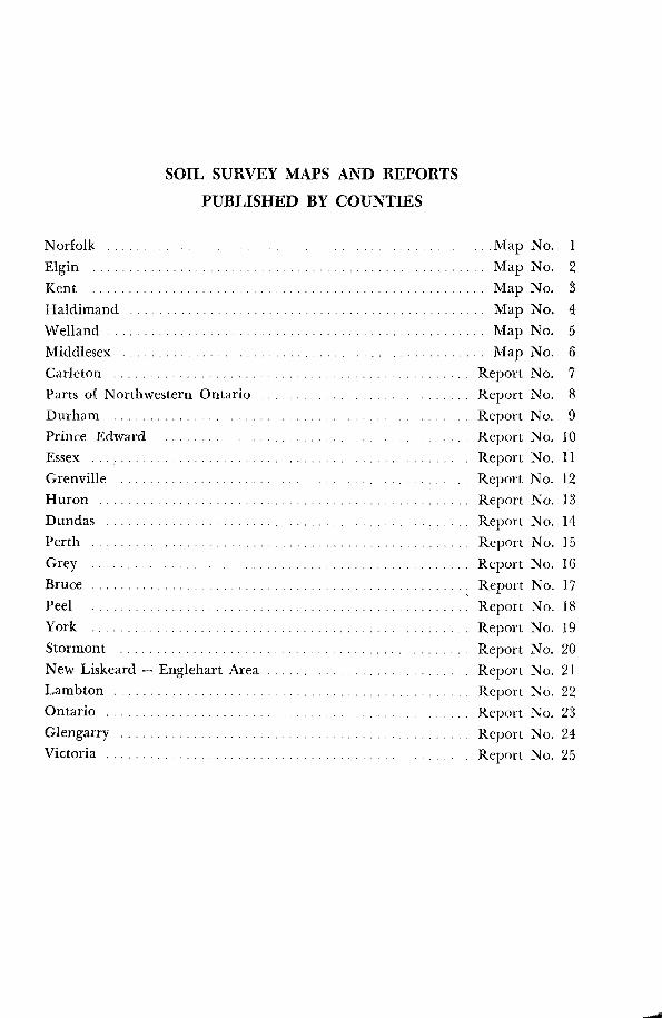
SOIL SURVEY MAPS AND REPORTSPUBLISHED BY COUNTIES
Norfolk . . . . . . . . . . . . . . . . . . . . . . . . . . . . . . . . . . . . . . . . . . . . . . . . . . . . .Map No. 1Elgin . . . . . . . . . . . . . . . . . . . . . . . . . . . . . . . . . . . . . . . . . . . . . . . . . . . . . . Map No. 2Kent
. . . . . . . . . . . . . . . . . . . . . . . . . . . . . . . . . . . . . . . . . . . . . . . Map No. 3Haldimand
. . . . . . . . . . . . . . . . . . . . . . . . . . . . . . . . . . . . . . . . . . . . . . . . .
Map
No.
4Welland . . . . . . . . . . . . . . . . . . . . . . . . . . . . . . . . . . . . . . . . . . . . . . . . . . . . Map No. 5Middlesex . . . . . . . . . . . . . . . . . . . . . . . . . . . . . . . . . . . . . . . . . . . . . . . . Map No. 6Carleton . . . . . . . . . . . . . . . . . . . . . . . . . . . . . . . . . . . . . . . . . . . . . . . . . Report No.
7Parts of Northwestern Ontario . . . . . . . . . . . . . . . . . . . . . . . . . . . . . Report No.
8Durham . . . . . . . . . . . . . . . . . . . . . . . . . . . . . . . . . . . . . . . . . . . . . . . . . Report No. 9Prince Edward . . . . . . . . . . . . . . . . . . . . . . . . . . . . . . . . . . . . . . . . . . . Report No. 10Essex . . . . . . . . . . . . . . . . . . . . . . . . . . . . . . . . . . . . . . . . . . . . . . . . . . . . Report No. 11Grenville . . . . . . . . . . . . . . . . . . . . . . . . . . . . . . . . . . . . . . . . . . . . . . . . Report No. 12Huron . . . . . . . . . . . . . . . . . . . . . . . . . . . . . . . . . . . . . . . . . . . . . . . . . . . Report No. 13Dundas . . . . . . . . . . . . . . . . . . . . . . . . . . . . . . . . . . . . . . . . . . . . . . . . . . Report No. 14Perth . . . . . . . . . . . . . . . . . . . . . . . . . . . . . . . . . . . . . . . . . . . . . . . . . . . . Report No. 15Grey
. . . . . . . . . . . . . . . . . . . . . . . . . . . . . . . . . . . . . . . . . . . . Report No. 16Bruce . . . . . . . . . . . . . . . . . . . . . . . . . . . . . . . . . . . . . . . . . . . . . . . . . . . Report No. 17Peel . . . . . . . . . . . . . . . . . . . . . . . . . . . . . . . . . . . . . . . . . . . . . . . . . . . . . Report No. 18York . . . . . . . . . . . . . . . . . . . . . . . . . . . . . . . . . . . . . . . . . . . . . . . . . . . . Report No. 19Stormont . . . . . . . . . . . . . . . . . . . . . . . . . . . . . . . . . . . . . . . . . . . . . . . . Report No. 20New Liskeard - Englehart Area . . . . . . . . . . . . . . . . . . . . . . . . . . . . Report No. 21Lambton . . . . . . . . . . . . . . . . . . . . . . . . . . . . . . . . . . . . . . . . . . . . . . . . . Report No. 22Ontario . . . . . . . . . . . . . . . . . . . . . . . . . . . . . . . . . . . . . . . . . . . . . . . . . . Report No. 23Glengarry . . . . . . . . . . . . . . . . . . . . . . . . . . . . . . . . . . . . . . . . . . . . . . . . Report No. 24Victoria . . . . . . . . . . . . . . . . . . . . . . . . . . . . . . . . . . . . . . . . . . . . . . . . . . Report No. 25
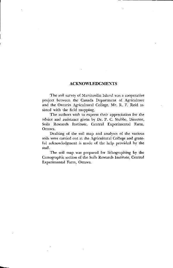
ACKNOWLEDGMENTS
The soil survey of Manitoulin Island was a cooperativeproject between the Canada Department of Agricultureand the Ontario Agricultural College. Mr. R. F. Reid as-sisted with the field mapping.
The authors wish to express their appreciation for theadvice and assistance given by Dr . P. C. Stobbe, Director,Soils Research Institute, Central Experimental Farm,Ottawa .
Drafting of the soil map and analyses of the varioussoils were carried out at the Agricultural College and grate-ful acknowledgment is made of the help provided by thestaff .
The soil map was prepared for lithographing by theCartographic section of the Soils Research Institute, CentralExperimental Farm, Ottawa.
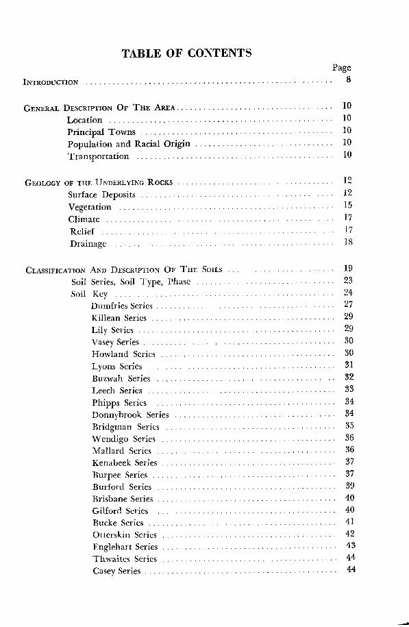
TABLE OF CONTENTSPage
INTRODUCTION . . . . . . . . . . . . . . . . . . . . . . . . . . . . . . . . . . . . . . . . . . . . . . . . . . . . . . .
GENERAL DESCRIPTION OF THE AREA . . . . . . . . . . . . . . . . . . . . . . . . . . . . . . . . . . .
10
Location . . . . . . . . . . . . . . . . . . . . . . . . . . . . . . . . . . . . . . . . . . . . . . . . . . 10Principal Towns . . . . . . . . . . . . . . . . . . . . . . . . . . . . . . . . . . . . . . . . . . .
10Population and Racial Origin . . . . . . . . . . . . . . . . . . . . . . . . . . . . . . .
10Transportation . . . . . . . . . . . . . . . . . . . . . . . . . . . . . . . . . . . . . . . . . . . . 10
GEOLOGY OF THE UNDERLYING ROCKS . . . . . . . . . . . . . . . . . . . . . . . . . . . . . . . . . .
12
Surface Deposits . . . . . . . . . . . . . . . . . . . . . . . . . . . . . . . . . . . . . . . . . . . 12
Vegetation . . . . . . . . . . . . . . . . . . . . . . . . . . . . . . . . . . . . . . . . . . . . . . . . 15Climate . . . . . . . . . . . . . . . . . . . . . . . . . . . . . . . . . . . . . . . . . . . . . . . . . . 17Relief . . . . . . . . . . . . . . . . . . . . . . . . . . . . . . . . . . . . . . . . . . . . . . . . . . . . 17Drainage
. . . . . . . . . . . . . . . . . . . . . . . . . . . . . . . . . . IS
CLASSIFICATION AND DESCRIPTION OF THE SOILS . . . . . . . . . . . . . . . . . . . . . . . . 19
Soil Series, Soil Type, Phase . . . . . . . . . . . . . . . . . . . . . . . . . . . . . . . 23
Soil Key . . . . . . . . . . . . . . . . . . . . . . . . . . . . . . . . . . . . . . . . . . . . . . . . . 24
Dumfries Series . . . . . . . . . . . . . . . . . . . . . . . . . . . . . . . . . . . . . . . .
27
Killean Series . . . . . . . . . . . . . . . . . . . . . . . . . . . . . . . . . . . . . . . . . 29
Lily Series . . . . . . . . . . . . . . . . . . . . . . . . . . . . . . . . . . . . . . . . . . . .
29
Vasey Series . . . . . . . . . . . . . . . . . . . . . . . . . . . . . . . . . . . . . . . . . . .
30Howland Series . . . . . . . . . . . . . . . . . . . . . . . . . . . . . . . . . . . . . . . 30Lyons Series . . . . . . . . . . . . . . . . . . . . . . . . . . . . . . . . . . . . . . . . . 31Buzwah Series . . . . . . . . . . . . . . . . . . . . . . . . . . . . . . . . . . . . . . . . 32Leech Series . . . . . . . . . . . . . . . . . . . . . . . . . . . . . . . . . . . . . . . . . . 33Phipps Series . . . . . . . . . . . . . . . . . . . . . . . . . . . . . . . . . . . . . . . . . 34Donnybrook Series . . . . . . . . . . . . . . . . . . . . . . . . . . . . . . . . . . . . 34Bridgman Series . . . . . . . . . . . . . . . . . . . . . . . . . . . . . . . . . . . . . . 35Wendigo Series . . . . . . . . . . . . . . . . . . . . . . . . . . . . . . . . . . . . . . . 36Mallard Series . . . . . . . . . . . . . . . . . . . . . . . . . . . . . . . . . . . . . . . . 36Kenabeek Series . . . . . . . . . . . . . . . . . . . . . . . . . . . . . . . . . . . . . . .
37Burpee Series . . . . . . . . . . . . . . . . . . . . . . . . . . . . . . . . . . . . . . . . . 37Burford Series . . . . . . . . . . . . . . . . . . . . . . . . . . . . . . . . . . . . . . . . 39
Brisbane Series . . . . . . . . . . . . . . . . . . . . . . . . . . . . . . . . . . . . . . . .
40Gilford Series . . . . . . . . . . . . . . . . . . . . . . . . . . . . . . . . . . . . . . . . .
40Bucke Series . . . . . . . . . . . . . . . . . . . . . . . . . . . . . . . . . . . . . . . . . . 41Otterskin Series . . . . . . . . . . . . . . . . . . . . . . . . . . . . . . . . . . . . . . . 42
Englehart Series . . . . . . . . . . . . . . . . . . . . . . . . . . . . . . . . . . . . . . .
43Thwaites Series . . . . . . . . . . . . . . . . . . . . . . . . . . . . . . . . . . . . . . . 44Casey Series . . . . . . . . . . . . . . . . . . . . . . . . . . . . . . . . . . . . . . . . . . .
44

PageEvanturel Series . . . . . . . . . . . . . . . . . . . . . . . . . . . . . . . . . . . . . . .
45Earlton Series . . . . . . . . . . . . . . . . . . . . . . . . . . . . . . . . . . . . . . . . .
46Cane Series . . . . . . . . . . . . . . . . . . . . . . . . . . . . . . . . . . . . . . . . . . . 48Campbell Series . . . . . . . . . . . . . . . . . . . . . . . . . . . . . . . . . . . . . . . 48Gordon Series . . . . . . . . . . . . . . . . . . . . . . . . . . . . . . . . . . . . . . . . 49Wolsey Series . . . . . . . . . . . . . . . . . . . . . . . . . . . . . . . . . . . . . . . . . 51Pike Series . . . . . . . . . . . . . . . . . . . . . . . . . . . . . . . . . . . . . . . . . . . .
52Bass Series . . . . . . . . . . . . . . . . . . . . . . . . . . . . . . . . . . . . . . . . . . . .
52Perch Series . . . . . . . . . . . . . . . . . . . . . . . . . . . . . . . . . . . . . . . . . . .
53Farmington Series . . . . . . . . . . . . . . . . . . . . . . . . . . . . . . . . . . . . . 54Kagawong Series . . . . . . . . . . . . . . . . . . . . . . . . . . . . . . . . . . . . . . 55Little Current Series . . . . . . . . . . . . . . . . . . . . . . . . . . . . . . . . . . 55Muck . . . . . . . . . . . . . . . . . . . . . . . . . . . . . . . . . . . . . . . . . . . . . . . . 56Marsh . . . . . . . . . . . . . . . . . . . . . . . . . . . . . . . . . . . . . . . . . . . . . . . . 56Rock-Wendigo Complex . . . . . . . . . . . . . . . . . . . . . . . . . . . . . . . 56Rock . . . . . . . . . . . . . . . . . . . . . ., . . . . . . . . . . . . . . . . . . . . . . . . . . 56
AGRICULTURAL METHODS AND SOIL MANAGEMENT . . . . . . . . . . . . . . . . . . . . . . . . .
57Soil Management . . . . . . . . . . . . . . . . . . . . . . . . . . . . . . . . . . . . . . . . . . 58Crop Adaptability Ratings for Manitoulin Island Soils . . . . . . . . . .
63
APPENDIX . . . . . . . . . . . . . . . . . . . . . . . . . . . . . . . . . . . . . . . . . . . . . . . . . . . . . . . . . . . 68Taxonomic Classification, Profile Descriptions and
Analytical Data . . . . . . . . . . . . . . . . . . . . . . . . . . . . . . . . . . . . . . . 68
MAP-Soil Map of Manitoulin Island in pocket back of report .
ILLUSTRATIONSFigure
Page1. Outline Map of Ontario Showing Location of Manitoulin Island . . . . .
72. Outline Map Showing Townships and Principal Centres . . . . . . . . . . . .
93. Outline Map Showing Bedrock Geology . . . . . . . . . . . . . . . . . . . . . . . . . . .
114. Outline Map Showing Distribution of Soil Materials . . . . . . . . . . . . . . . .
13

OUTLINE MAPOF
ONTARIO
SNOWING LOCATION OF
MANITOULINISLAND
FIGURE 1 : Outline Map of Ontario Showing Location of Manitoulin Island .
MILES160
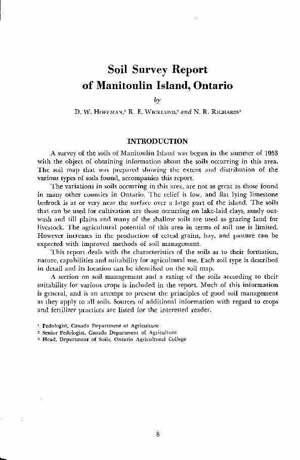
Soil Survey Reportof Manitoulin Island, Ontario
by
D. W. HOFFMAN,' R. E. WICKLUND,' and N. R. RICHARDS3
INTRODUCTION
A survey of the soils of Manitoulin Island was begun in the summer of 1953with the object of obtaining information about the soils occurring in this area .The soil map that was prepared showing the extent and distribution of thevarious types of soils found, accompanies this report .
The variations in soils occurring in this area, are not as great as those foundin many other counties in Ontario. The relief is low, and flat lying limestonebedrock is at or very near the surface over a large part of the island. The soilsthat can be used for cultivation are those occurring on lake-laid clays, sandy out-wash and till plains and many of the shallow soils are used as grazing land forlivestock. The agricultural potential of this area in terms of soil use is limited.However increases in the production of cereal grains, hay, and pasture can beexpected with improved methods of soil management .
This report deals with the characteristics of the soils as to their formation,nature, capabilities and suitability for agricultural use. Each soil type is describedin detail and its location can be identified on the soil map.
A section on soil management and a rating of the soils according to theirsuitability for various crops is included in the report. Much of this informationis general, and is an attempt to present the principles of good soil managementas they apply to all soils . Sources of additional information with regard to cropsand fertilizer practices are listed for the interested reader.
1 Pedologist, Canada Department of Agriculturez Senior Pedologist, Canada Department of Agriculture3 Head, Department of Soils, Ontario Agricultural College


Location
GENERAL DESCRIPTION OF THE AREA
Manitoulin Island is located in the northern part of Lake Huron approxi-mately at 45° latitude and 82° longitude. It is said to be the largest "freshwater"island in the world.
The total land area is about 712,000 acres (1,100 square miles) of which290,000 acres or about 40 per cent is occupied farin land .
Principal Towns
There are two incorporated towns on the Island each having less than2,000 inhabitants. Gore Bay (770) is the shopping and administrative centre forthe western end of the Island . The office of the Agricultural Representative islocated here and nearby is a large Canadian Government airport. Little Current(1,614) is the gateway to the mainland, the only railway contact and chief port.
The small unincorporated centres of South Baymouth, Sheguiandah,Mindemoya, Kagawong, Spring Bay, Silverwater and Meldrum Bay, provideshopping facilities and tourist accommodation.
Population and Racial Origin
According to the 1951 Census the total population of the Island was 11,214 .Approximately 90 per cent (9,817) of the people were rural dwellers but only46 per cent lived on farms.
The trend in population from 1871 to 1951 is shown in Table 1 .
TABLE 1TREND IN TOTAL POPULATION
TABLE 2POPULATION BY PRINCIPAL ORIGINS, 1951 CENSUS
TransportationManitoulin Island is fairly well supplied with roads but transportation
facilities from the Island to the mainland are poor. Roads traverse the Islandconnecting the population centres. Many of the main roads are oil surfaced butthe township roads are few in number and often rough. A rough, twisting roadfrom Little Current to Espanola is the only connecting road from the Island tothe mainland . Running more or less parallel to this road is a spur line of theCanadian Pacific Railway which ends at Little Current.
1 0
YEAR POPULATION YEAR POPULATION1871 . . . . . . . . . . . . . . . . . � 2,231 1921 . . . . . . . . . . . . . . . . . . 10,4681881 . . . . . . . . . . . . . . . . . � 8,460 1931 . . . . . . . . . . . . . . . . . . . 10,7341891 . . . . . . . . . . . . . . . . . . 10,794 1941 . . . . . . . . . . . . . . . . . . . 10,8411901 . . . . . . . . . . . . . . . . . � 11,828 1951 . . . . . . . . . . . . . . . . . . . 11,2141911 . . . . . . . . . . . . . . . . . . 11,324
Canadians of British Origin . . . . . . . . . . . . . . . . . . . . . . 7,690 68.6°]0Native Indians . . . . . . . . . . . . . . . . . . . . . . . . . . . . . . . . . 2,450 21 .9°/0Canadians of French Origin . . . . . . . . . . . . . . . . . . . . . 515 4.6%Canadians of Other Origins . . . . . . . . . . . . . . . . . . . . . 559 4.9°J�
Total Population . . . . . . . . . . . . . . . . . . . . . 11,214 100.0%
OOW
YUO
Wm
\\
\I`\
\~\\\ \
`\ vlv \
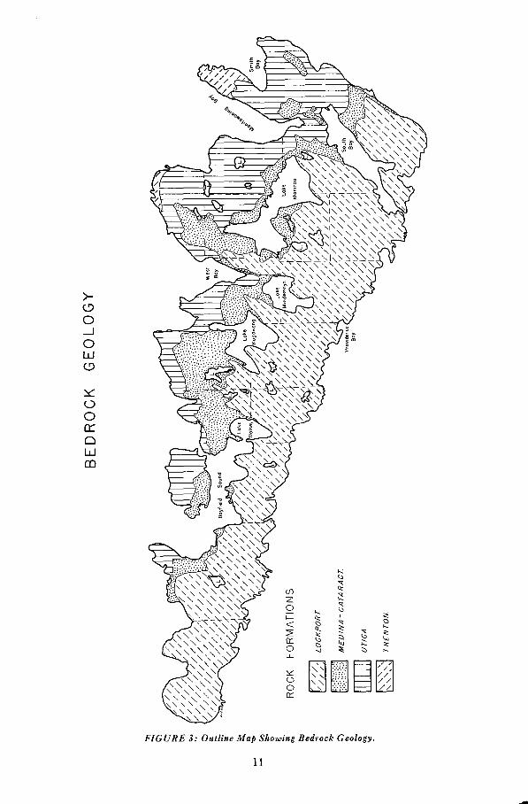
FIGURE 3: Outline Map Showing Bedrock Geology .
11

Geology of the Underlying RocksManitoulin Island is underlain by rocks of Ordovician and Silurian ages
which outcrop in many places . Limestones of the Trenton, Medina-Cataract andLockport formations and shales of the Utica and Meaford formations are present.
The Trenton formation is seen only on the northeast part of the Island nearLittle Current and again on the long peninsula farther east that terminates inBold Point. This limestone is of the magnesian variety and contains on theaverage 6 per cent of silica, iron and alumina.
The dolomite of the Medina-Cataract formation is also siliceous and argil-laceous containing on the average about 7 per cent of impurities . This dolomiteis dark brown to dark bluish grey in colour with seams of blue shale occurring insome localities . It is hard and contains silicified fossils and small nodules ofwhite chert .
The Lockport dolomite which composes the major part of the Island, is over300 feet thick . `Vest of Campbell Bay this dolomite is brown and has a high silicacontent with numerous silicified fossils. A very pure cream to buff colouredporous dolomite is more common east of Campbell Bay. Some of the purest lime-stone on the Island occurs at South Baymouth .
The shales of the Utica and Meaford formations are grey to dark bluish greyin colour and contain layers of calcareous sandstone and sandy shale .
TABLE 3ANALYSES OF THE UNDERLYING LIMESTONE FORMATIONS
MANITOULIN ISLAND
Samples for analyses from :(1) LITTLE CURRENT
(2) GORE BAY
12
EVANSVILLE
A ridge of white quartzite of Precambrian age protrudes through the Pal-aeozoic strata appearing in the neighbourhood of Sheguiandah.
The distribution of the different bedrock formations is shown in Figure 3.
Suface DepositsThe surface deposits in the Manitoulin area are chiefly of glacial origin and
they form the parent material from which the soils have developed . The varia-tions that occur in texture, relief and drainage of soils are a result of differencesin the nature o£ these deposits .
The principal types of surface deposits are described in Table 4 and theirdistribution is shown in Figure 4.
A large part of the Island consists of scoured rock plains, that are flat, andcovered with only a few inches of soil . In some places the drift deposits by the
1TRENTONFORMATION
2MEDINA
FORMATION
3LOCKPORTFORMATION
Silica (Si 02). . . . . . . . . . . . . . . . . . . . . . . . . . . . . . . . . . . . . . 4.16 6.50 1 .22Ferric Oxide (Fe2 03) . . . . . . . . . . . . . . . . . . . . . . . . . . . . . . 0 .80 0.54 0.14Alumina (A12 03) . . . . . . . . . . . . . . . . . . . . . . . . . . . . . . . . . . 1 .46 1 .84 0.32Calcium Phosphate (Ca3(PO4)2) . . . . . . . . . . . . . . . . . . . . . . 0.09 0 .11 0.02Calcium Carbonate (Ca CO3) . . . . . . . . . . . . . . . . . . . . . . . 82 .41 50.16 53.54Magnesium Carbonate (Mg CO . . . . . . . . . . . . . . . . . . . . 10 .54 40.95 43.96
Total . . . . . . . . . . . . . . . . . . . . . . . . . 99.46 100.10 99.20

H
O
W
WUQ
U)
1 3
"R1104
FIGURE 4: Outline Map Showing Distribution of Surface Deposits .
melting ice of the Wisconsin glaciation, is deeper and till plains, drumlins,moraines, outwash plains and lake-laid silts and clays occur.
The glacial till materials occur near Lake Manitou, Manitowaning Bay andthe eastern part of the north shore and also as underlying deposits below thelacustrine and outwash materials of the various basins and depressional areas.This till is generally coarse textured and consists of a mixture of boulders, cobbles,gravel, sand, silt and clay . These materials have formed loam to clay loam soilswith various degrees of stoniness and a topography which varies from regularmoderately sloping to irregular, hilly.
Ground moraine, which is by far the most extensive form in which thesetill deposits occur in this area, is characterized by knolls and numerous sloughs.The terminal moraine on the other hand is usually rough consisting of hills thatwere formed at the terminus of the glacier when it melted . An area of ter-minal moraine occurs a few miles south of Little Current.
Another form of till deposit is the elongated hill or drumlin. ManitoulinIsland has about 175 drumlins . They were all submerged in Lake Algonquinand as a result of wave action large numbers of boulders remain on their crownsand sides.
Outwash deposits are represented by coarse material sorted from glacial tillby rapidly-flowing glacial streams.
During the process of sorting the fast-flowing water removed most of the siltand clay and left a residue of sand, gravel, cobbles and boulders . These coarsetextured materials were laid down in running water in patterns which are recognized as outwash plains, beaches and kames. The outwash plains occur asgravelly or sandy areas having gently sloping topography . Gravel bars are
common on the Island having been produced by various receding levels ofLake Algonquin.
2.
3.
4.
TABLE 4SURFACE DEPOSITS OCCURRING IN THE MANITOULIN MAP AREA
GLACIAL TILL :DEPOSIT
DESCRIPTION
Ground Moraine . . . . . . . . . Generally unsorted material . Topography is characterized bya succession of low knolls and depressions . Textures are loamto clay loam -contains stones and boulders . .
Terminal Moraine . . . . . . . Often modified or resorted . Topography is rough to hilly .Textures range from sandy loam to clay loam -stonier thanground moraine.
Drumlin. . . . . . . . . . . . . . . . Elongated hill lined in the direction of ice advance, usuallyunsorted . Textures loam to clay loam . Contains stones andboulders.
GLACIO-FLUVIAL :Outwash Plain . . . . . . . . . . . Sandy and gravelly area occurring on a nearly level plain but
may be marked by enclosed depressions and by incised ravines .Often cobbly but is usually boulder-free .
Kame . . . . . . . . . . . . . . . . . . Short hill of sand
and
gravel - may contain resorted till .Contains some stones and boulders .
LACUSTRINE . . . . . . . . . . . . . . Clays, silts and sands laid down in glacial lakes. Topography isusually very gently sloping, although moderately steep slopesare encountered in some areas. Stones are few to absent exceptin areas where thin lacustral deposits are underlain with till .
RECENT ALLUVIAL . . . . . . . Post-Glacial deposits of sands, silts and clays along streams,meadows, sloughs and marshes. Also includes mucks and peats.Soils are immature ; topography is nearly level to depressional .Stones are rare.
1 4

The kame deposits, consisting of gravel, occur in the forth of -Short hills . Ingeneral these hills of gravel are associated with till deposits occurring also in arough topography .
The lacustrine deposits occupy the lower flatter areas which represented thebed of glacial Lake Algonquin . Most of the glacial lake deposits have regular,gently sloping topography although some dissection by streams has caused unevetitiess of the terrain . The texture of ¬ lie lacustrine deposits varies from siltloarn to clay . Most of these deposits are Free of stone, particularly where they arethick . Where snore than an occasional boulder is encountered the lacustrine de-posit is usually thin and the underlying till is close to the surface. Some stonesand boulders may have been rafted into these lakes by ice .
Deposits of organic materials occur throughout the Island . They are thepartly decayed remains of trees, shrubs anti mosses and have been classifiedas muck.
VegetationThe tyke of natural vegetation found in an area is determined by climatic
and soil factors . When vegetation becomes established it in turn exerts consider-able influence on the development of a soil and therefore is an important factorin soil formation . The extent to which vegetation influences soil developmentvaries with the type of vegetation .
Since vegetation is one of several inter-related soil forming factors, it is verydifficult to meayurc the exact effect that it has had on the profile features whichare used to make soil type separations . A survey of the vegetation shows, in ageneral way, what tree associations most commonly occur on some of the more
R typical woodlor an Manirordin Island.
15

TABLE 5TEMPERATURE AT GORE BAY, PROVIDENCE BAY AND OTHER SELECTED POINTS
MONTH
*Years Observed .
TEMPERATURE IN DEGREES F.
important soils . This information is given in the discussion of each soil series inthe next chapter of this report .
The most commonly occurring trees are sugar maple, red maple, elm, bass-wood, yellow birch, red and white oak, ironwood, beech, white and black ash,
1 6
PROVIDENCEGORE BAY BAY KAPUSKASING HUNTSVILLE BRANTFORD
(22)* (26) (19) (30) (51)
December . . . . . . . . . . . . . . 21 22 6 19 26
January . . . . . . . . . . . . . . . 14 16 -2 14 22
February . . . . . . . . . . . . . . . 13 15 2 12 20
Winter . . . . . . . . . . . . . 16 18 2 15 23
March . . . . . . . . . . . . . . . . . 24 25 14 24 31
April . . . . . . . . . . . . . . . . . 35 37 31 39 43
May . . . . . . . . . . . . . . . . . . 50 48 36 52 55
Spring . . . . . . . . . . . . . 36 37 30 38 43
June . . . . . . . . . . . . . . . . . . 60 57 57 , 61 65
July . . . . . . . . . . . . . . . . . . . 66 64 62 66 70
August . . . . . . . . . . . . . . . . 64 63 60 64 67
Summer . . . . . . . . . . . 63 61 60 64 67
September . . . . . . . . . . . . . 57 57 51 57 61
October . . . . . . . . . . . . . . . 46 46 39 45 48
November . . . . . . . . . . . . . . 33 ` 33 22 32 37
Fall . . . . . . . . . . . . . . . 45 45 37 45 49
Annual . . . . . . . . . . . . . . . . 40 40 32 41 45
May I to Oct. I . . . . . . . . 59 58 55 60 64

aspen, and white birch. Conifers are scattered generally but in no great quantityand consist of white and red pine, white spruce, balsam, fir, and hemlock.
Climate
There are two meteorological stations on Manitoulin Island located at GoreBay and Providence Bay. Climatic data is presented in Tables 5 and 6 fromthese stations and other selected points . Data from Kapuskasing are included torepresent the northern coniferous region and that from Huntsville representsthe transitional zone between hardwoods and conifers . Records from Brantfordare included to represent the hardwood region in Southern Ontario.
According to Table 5 the winters in the surveyed area are cold with a meantemperature of 16° to 18°F and the summers are warm with a mean temperatureof 61° to 64°F. Temperature differences between the regions listed are greaterin winter than in summer . For instance the difference between Gore Bay andBrantford is 7 degrees in February and 4 degrees in July . In May the mean tem-perature at Gore Bay has risen above 42 degrees which is sometimes used as avalue to mark the beginning of crop growth .
The extreme high records are 97 degrees and 100 degrees. The lowest tem-perature on record is minus 41 degrees, giving an extreme range of 141 degreeswhich is rather wide for a region surrounded by water.
The frost free period averages 125 to 129 days from about May 26 to theend of September, however, frosts have been recorded in all months . The growingseason opens April 24 to 26 and closes October 21 to 25 ; the average length being178 to 186 days .
Precipitation includes both rain and snow with the latter recalculated toits rainfall equivalent in inches of a ratio of ten to one. The average annualprecipitation at Providence Bay is 31 .57 inches, one third of which falls duringthe growing season .
There is a winter maximum and summer minimum in precipitation. Thelight rainfall in March and April is favourable as it allows the land to dry upso that it may be cultivated . However the precipitation for the summer monthsis also low resulting in a high drought frequency. As a result pastures becomedry, grasses wither, and the carrying capacity of the natural pasture is consider-ably reduced.
Snowfall ranges from 83 to 118 inches . The climate of Manitoulin Islandis in brief one of moderately cold, snowy winters with late springs, dry and sunnysummers and open falls.
Relief
In general, Manitoulin Island varies in altitude from 600 to 800 feet abovesea level with some hills above 1000 feet . Along the south shore of the Islandthe rocky floor dips gradually under the water but perpendicular cliffs arecommon near the north shore. For the most part the relief of the Island is levelto undulating .
1 7

DrainageManitoulin Island contains more than one hundred lakes, the three largest,
Kagawong, Mindemoya, and Manitou, together cover more than 65 squaremiles. Rivers draining the area are generally shallow and small. The largest areBlue Jay Creek, Manitou Creek and Mindemoya River. These flow in a southerlydirection and empty into Lake Huron.
TABLE 6PRECIPITATION AT GORE BAY, PROVIDENCE BAY AND OTHER SELECTED POINTS
18
MONTH
GORE BAY(22)*
PRECIPITATION IN INCHES
PROVIDENCEBAY KAPUSKASING HUNTSVILLE(26) (19) (30)
BRANTFORD(51)
December . . . . . . . . . . . , . . 2 .97 3 .22 1 .90 3 .28 2 .24
January. . . . . . . . . . . . . . . . 2 .45 4.27 2 .00 3 .09 2 .61
February . . . . . . . . . . . . . . . 1 .98 3 .01 1 .06 2 .45 2 .12
Winter . . . . . . . . . . . . 7 .40 10 .50 4 .96 8 .82 6 .97
March . . . . . . . . . . . . . . . . . 2 .32 2 .59 1 .56 2 .78 2 .16
April . . . . . . . . . . . . . . . . . . 2 .19 1 .97 1 .82 2 .09 2 .54
May . . . . . . . . . . . . . . . . . . 2 .12 1 .86 2 .12 2 .85 2 .90
Spring . . . . . . . . . . . . . 6 .63 6.42 5 .50 7 .74 7 .60
June . . . . . . . . . . . . . . . . . . 2 .25 2 .43 2 .33 3 .69 2 .65
July . . . . . . . . . . . . . . . . . . . 1 .90 1 .95 3 .43 2 .96 3 .05
August . . . . . . . . . . . . . . . . 2 .03 1 .91 2 .94 2 .70 2 .93
Summer . . . . . . . . . . . 5 .78 6 .29 8 .70 9 .35 8 .63
September . . . . . . . . . . . . . 2 .81 2 .59 3 .54 3 .84 2.63
October . . . . . . . . . . . . . . . 2 .98 3 .00 2 .50 3 .44 2 .47
November . . . . . . . . . . . . . . 3 .09 2 .72 2 .39 3 .24 2 .40
Fall . . . . . . . . . . . . . . . 8 .88 8 .31 8 .43 10 .52 7 .50
Annual . . . . . . . . . . . . . . . . 29 .09 31 .52 27 .59 36 .41 30 .70
May 1 to Oct. 1 . . . . . . . . 11 .11 10 .74 14 .36 16 .04 14.16
*Years observed .

THE CLASSIFICATION AND DESCRIPTION OF THE SOILS
The surface geological deposits previously described are the parent materialsfrom which the soils have developed . This development has taken several formsas a result of differences in the parent materials as well as the effects producedby differences in drainage and in vegetation .
Under the cool humid conditions present in this region, and with forestvegetation, the processes of soil development tend toward acid conditions . Thisacid condition is the result of the removal of bases, particularly calcium, fromthe surface layers of the soil by percolating water. This is referred to as a processof leaching and the effect produced on the soil is in the development of layers orhorizons that differ from one another in thickness, colour, texture and structure.
A cut made through the horizons exposes what is known as the soil profile.In agricultural practice it is often customary to refer to the different combinationsof horizons as surface soil, subsurface soil, subsoil and parent material . Howeverbecause many soils have more than four horizons it is convenient to use thespecific pedological terms A horizon, B horizon and C horizon which arefurther designated as Ao, A� A� Bl, B2, C, etc. for more detailed and accuratedescriptions where the main soil horizons are subdivided .
The A horizon is the horizon where maximum weathering takes place andfrom which the downward movement of water removes the bases. In many soilsthe A horizon can be subdivided into A, and A2. The A, horizon contains thelargest amounts of organic matter and the A, is the horizon of greatest leachingor eluviation . Some of the materials leached from the A, accumulate in the Bhorizon. The B horizon is often finer in texture and more compact as a resultof the accumulation of clay and other fine materials carried down from the Ahorizon. Underlying the B horizon is the C horizon which may be unaltered oronly slightly altered by the soil forming processes . The geological deposits onwhich the soil is developed are known as parent material .
Poorly drained soils in which ground water stands in the soil profile havea condition designated as "Gley" . The gley or G horizon is a layer in whichintermittent water logging causes partial oxidation and reduction of iron andis recognized by bluish grey, brownish grey as well as mottled colours and thepresence of iron concretions.
Soils are classified on the basis of the development of the horizons whichmake up the soil profile .
Eighty-one different soils were recognized and mapped on the Island . Thesesoils differ from one another in one or more of the following features of the soilprofile - number, colour, thickness, texture, structure and chemical compositionof the horizons, or in drainage, depth to bedrock and stoniness .
Because many soil series have certain features in common they are groupedinto Great Soil Groups . Those occurring on Manitoulin Island are Alluvial,Brown Forest, Grey-Brown Podzolic, Grey Wooded, Brown Podzolic, Podzol,Dark Grey Gleisolic, Shallow Organic and Organic. A generalized descriptionof some of these groups follows.
19
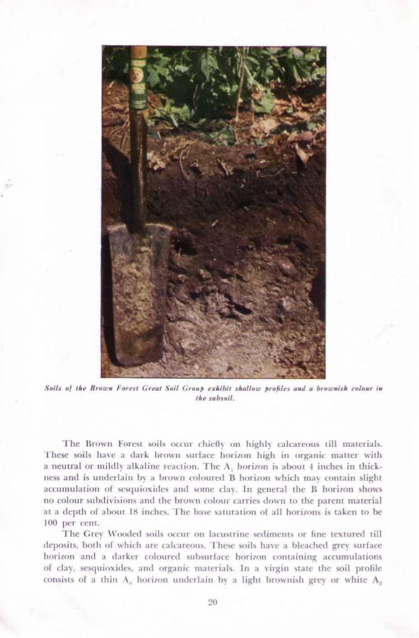
Sails of tke Brown Forest ! :rear Soil Crorlp < " 7lrilrir .shollow profiles and a hroce~nish colour ireMe sreb .s"il .
The
13ren"rl
Forest
,arils
4)(t - ttt-
c hicliN
oil
It igltl~
calcareous
till
materials.These soils have a dark Ll1oF1'n Stt1-LICe 1tnri/tnt high ill org;mic matter witha neutral or mild!% alk ;iliiic reaction . - I'll(- A, lurtinrn is about 1 inches in thickness and is unt]urlairt by ;r Irreorn culerurt'd B 1106,1011 'Which tllay rtrtttain slightaccu]]ltilittion of seselutrrXides and Sonle clay . In general t11r 13 1101 -t/ntl ShOWsno colexiir sulnlitisioti, aittl iltc In mv 11 colour titrries elo1'it tee the parent Iliaterialat a tleptlt of ;ilmtit IS ill( lie ,, . f lte IYiSC Satu : -atiOii etl all lvrri,~rnts is taken to 11e
100 per uctit .The Grr~
Ll'troded soils oue uY 11E1 lacustrine ,etlilncnt, err fine textureel tilldeposits . both of whie11 arc' t ;tlear[°ertts . Z fic t_~ grits have. .t hleadled qtr- surfacehoriinn anti a darkut tetlmired ,tilrsttrlaee horifort ccrcttaitrittg accumulationsof clay . seseluiirxidc,, mid trt.ganie ntmeri;ils . fit a virgin st ;ttc' tit(- soil profileconsists of a iltitr :1 � lurri/mt iimlerkiirt In- a lit;hi ln ,mrrri,lt greN or white

is I'er{' thin .
2 1
This profrle exhibits the characteristics of the Grey Wooded Great Sail Group. The A, horiaoa
horizon, that is yea'-, low in organic matter Lind is slightly to niotlcrately acid inreaction . The 1`3 horizon is dark imrown in colour . contains more clay and sesqui-oxitles than the horizons alcove and some form of blocky structurc. The greyingfrom the A_ horizon carries down over the upper hart of the l3 to form a pro-nounced AB horizon . As a crlnscgUCUCe the prolllc exhibits an overall greyishcolour. Depths of profiles are usually ?f3 to ?h inches.
The Grey-Brown Podzolic soils in this area occur only on coarse textureddeposits. CTnder normal conditions dicv Miller from the Grev Wooded on thebasis of colour and also on thc, aicveloprrient of the surface horizons, The profilepossesses a dark greyish brown A, horizon, :9 inrlies thick and relatively highin organic matter, whilli is underlain by a ycllowish brown A_ horizon thatbeconies lighter in tealiai3 wide depth . 'l lie l3 horizolt is brown ill colour and is

-q- .x""x. .
-- : .~ .A Grey-Brown l'odzolir Snil I'rufele .
finer in texture than other horizons in the profile. It contains accurnttlations ofclay . The calcareous parent material occurs at depths of `?I1 to 30 inches .
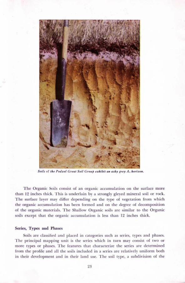
The Podzol soils have an :1 � lmriron I to 2 inches thick which is underlainby a grey or White A_ horizon varying from 1 to 2 incites in thickness . The Rhorizon is reddish brown and contains accumulations of sesquioxides and organicmatter or both and is usually divisihle into two suhhorizons P', and I3__ .
A large part of the deep soils on Manitoulin Island have developed underpoorly drained C(1t1[liliOlt5, The poorly drained soils of the Island are repre-sentative of the Dark Grey Gleim7lir and Organic Great Soil Groups .
The Dark Grey Gle15oliC soils have a nliaicrtd surface soil high in organicmatter and a dull coloured subsoil wish yellow and orange rtmtding . In theprofile a very dark grey A, horizon generally i to 8 incites thick occurs . This isunderlain by a tuottIetf dark grey to greyish brown "giro" horizon which restson the parent material .
Series, Types and Phases
"
so, , -or
Soils r," f the i'udzW GrraI Soil f,rirrrp exhihif an ash v "vet
1, ho') i ;00 .
The Organic Snits consist of an organic accuttiulatiort On the surface morethan 1`? inches thick . This is underlain by a strongly gleyCil tiiineral soil or rock .
"1 - 11C surface layer may differ depenrlittg oil the typc of vegetation from whichthe organic iICCtniittlatlon has been formed and on the degree of decompositionof the organic materials, The Shallow Organic soils are similar to the Organic
soils except that the organic accutlrtikal .irm is less than 1`? inches thick .
Soils are classified and hi,accd ill categories such as series, types and phases .The principal niappitig unit is the series Which in turn may consist of t%vo ormore types or phases . The features that Characterize the series are determiner!front the profile and all the soil~ included ill a %dries are relatively uniform both
in their develolmiettt artd ill their farad use . The soil type . a subdivision of the
"'i

Nate Plrroile
- harrirlr ri .9rirs 0 u Drip k
r,r r,S
r,1, i.cr,hr
,wi
`err lrrr r
, "z
a dark grey roirzrrr ;sabsoil rr drub grey reith reddi.+'!r brrr :, yi nzwrli+z~ .
soil series, is based on the texture of the slll'IiACC soil . The Full name of the soiltype is a combination of the series ttaatte and the surface texture . fnr t'xaratlale,Little C.atrrent cl :n . 'I tic , soil phase. i s snot a part of the natural classific :itirrn ofsoils anti can be :i subtli-ision of the soil type, series or ativ- other Caassifieaiion
unit . Phases ;are ustmily subtiirisicstiti of soil ivlrcs and are based on externalcharacteristi(-s of the soil . 'I hcsc separations :ire inirrxltttecl to shOW differencesill slope, degree of ernsiost or crnttettt til surface slime .
The soils of Maraitraulin ISlattd have been rlas%ified and grouped oti thebasis of differerwes in lrareaat Material and drainage ;is preseatted in the keybelow .
A . Soils Developed on Glacial Till
Soil :
h la
1 . Stony, calcareous, sandy loam parent material(a) Gn(O 17raiuagc
I . lytanlraft learn (GAIT.)
1 .2{X1
11.2
r , oAcreage Total

25
Acreage% ofTotal
(b) Imperfect Drainage1 . Killean loam (G.B.P.) 100 -
(c) Poor Drainage1 . Lily loam (D.G.G .) 100 -
11 . Calcareous, loam parent material(a) Good Drainage
1 . Vasey loam (B.P.) 12,800 1 .82. Vasey loam-shallow phase (B,P .) 1,000 0 .2
(b) Imperfect Drainage1 . Howland loam (B.P .) 5,900 0 .82. Howland loam-shallow phase (B.P .) 2,100 0 .33. Howland sandy loam (B .P .) 100 -
(c) Poor Drainage1. Lyons loam (D.G.G.) 3,500 0 .52 . Lyons loam-shallow phase (D.G.G .) 2,300 0 .3
III. Calcareous, clay loam parent material(a) Good Drainage
1 . Buzwah clay loam (G.W.) 22,400 3 .12. Buzwah silty clay loam (G.W.) 2,100 0 .33. Buzwah clay loam - shallow phase (G.W.) 2,200 0 .34. Buzwah silty clay loam -stony phase (G.W.) 8,500 1 .3
(b) Imperfect Drainage1 . Leech clay loam (G.W.) 7,800 0 .72. Leech silty clay loam (G.W.) 1,000 0 .23. Leech clay loam -shallow phase (G .W.) 2,600 0 .44. Leech silty clay loam-shallow phase (G.W.) 2,400 0 .35. Leech silty clay loam-stony phase (G.W.) 700 0 .1
(c) Poor Drainage1 . Phipps clay loam (D.G.G .) 2,700 0 .42. Phipps silty clay loam (D.G.G .) 700 0 .13. Phipps clay loam-shallow phase (D.G.G .) 500 0 .14. Phipps silty clay loam -stony phase (D .G.G.) 300 -
B. Soils Developed on Outwash
1. Stone and gravel parent material(a) Good Drainage
1 . Donnybrook sandy loam (G.B .P .) 3,100 0 .5
11 . Medium and fine sand parent material(a) Good Drainage
1 . Bridgman sand (R) 1,700 0 .22 . Wendigo sandy loam (P) 21,400 3 .03. Wendigo sand (P) 800 0 .14. Wendigo fine sandy loam (P) 1,400 0 .2
(b) Imperfect Drainage1 . Mallard sandy loam (P) 3,200 0 .52. Mallard sandy loam-stony phase (P) 100 -3. Mallard sandy loam -shallow phase (P) 200 -
(c) Poor Drainage1 . Kenabeek sandy loam (D.G.G.) 7,500 1 .2
(d) Very Poor Drainage1 . Burpee muck (S.O .) 1,000 0 .3
111 . Loam and sandy loam deposits underlain by gravel(a) Good Drainage
1 . Burford loam (G.B .P .) 13,200 1 .92. Burford loam-shallow phase (G.B .P .) 300 -3. Burford sandy loam (G.B .P .) 500 0 .1
(b) Imperfect Drainage1 . Brisbane loam (G.B .P .) 600 0 .1
(c) Poor Drainage1 . Gilford loam (D.G.G.) 1,600 0 .22. Gilford sandy loam (D.G.G .) 300 -

26
C. Soils Developed on Sands Underlain by Silty ClayAcreage
%ofTotal
(a) Good Drainage1 . Bucke fine sandy loam (P) 1,200 0 .22. Bucke sandy loam (P) 900 0.1
(b) Imperfect Drainage1 . Otterskin sandy loam (P) 2,200 0 .32. Otterskin fine sandy loam (P) 1,000 0 .2
(c) Poor Drainage1 . Englehart fine sandy loam (D.G.G .) 2,000 0 .32. Englehart sandy loam (D.G.G.) 800 0 .1
D. Soils Developed on Lacustrine Deposits
I. Non-Calcareous Silt Loam Underlain by Silty Clay(a) Good Drainage
1 . Thwaites silt loam (P) 3,100 0 .4(b) Imperfect Drainage
1 . Casey silt loam (P) 1,000 0 .2
II. Calcareous silt loam parent material(a) Good Drainage
1 . Evanturel silt loam (G.W.) 6,500 0 .92. Evanturel silt loam-stony phase (G.W.) 100 -3. Evanturel silt loam -shallow phase (G.W .) 100 -
(b) Imperfect Drainage1 . Earlton silt loam (G.W.) 10,600 1 .52. Earlton silt loam-stony phase (G.W.) 500 0 .13. Earlton silt loam-shallow phase (G.W.) 500 0 .1
(c) Poor Drainage1 . Cane silt loam (D.G.G .) 4,500 0 .62. Cane silt loam-stony phase (D.G.G .) 100 -3. Cane silt loam-shallow phase (D.G.G .) 100 -
III. Calcareous silty clay parent material(a) Good Drainage
1 . Campbell silty clay loam (G.W.) 4,300 0 .62. Campbell silty clay loam-stony phase (G.W.) 500 0 .13. Campbell silty clay loam-shallow phase (G.W .) 200 -4. Campbell silty clay loam-shallow, stony phase (G.W.) 500 0 .1
(b) Imperfect Drainage1 . Gordon silty clay loam (G.W.) 21,400 3 .02. Gordon silty clay loam-stony phase (G.W.) 1,500 0 .23. Gordon silty clay loam-shallow phase (G .W.) 2,600 0.44. Gordon silty clay loam-shallow, stony phase (G.W.) 1,900 0.3
(c) Poor Drainage1 . Wolsey silty clay loam (D.G.G .) 9,500 1 .32. Wolsey silty clay loam-stony phase (D.G.G .) 600 0 .13. Wolsey silty clay loam-shallow phase (D.G.G .) 400 -4. Wolsey silty clay loam-shallow, stony phase (D.G.G .) 1,000 0 .2
IV . Calcareous clay parent material(a) Good Drainage
1 . Pike clay (G.W .) 1,000 0 .22. Pike clay-stony phase (G.W .) 800 0 .1
(b) Imperfect Drainage1. Bass clay (G.W.) 500 0 .12. Bass clay-stony phase (G.W.) 600 0 .1
(c) Poor Drainage1 . Perch clay (D.G.G .) 500 0 .12. Perch clay - stony phase (D.G.G .) 1,000 0 .2
E . Shallow Soils
A. Soils Developed on Glacial Till
GREAT SOIL GROUPS
A
- Alluvial
B.F .
- Brown Forest
O.
- Organic
B.P .
- Brown Podzolic
D.G.G . - Dark Grey Gleisolic
G.B.P . - Grey-Brown Podzolic
G.W. -Grey Wooded
P.
- Podzol
S.O.
- Shallow Organic
R
- Regosol
DUMFRIES SERIES
% ofAcreage Total
These soils occupy a continuous block of land 1,200 acres in size on theeastern end of Manitoulin Island a few miles south of the town of Little Current.They are developed on stony soil material which has been derived mainly fromlimestone rocks. The material is therefore calcareous, and free carbonates canbe found at depths of 18 to 24 inches .
The topography is more rugged than is characteristic of other soils on theIsland . Slopes are steep, irregular and generally short. All of the Dumfries soilsare well drained but associated imperfectly and poorly drained areas are to befound in the depressions. These depressions often occur as "potholes" and containwater during a large part of the year . They cannot be easily drained and therefore
are not arable . The soils are stony and possess both granite and limestone bouldersat the surface and throughout the soil mass.
27
I. Calcareous loam and silt loam material underlain by limestone(a) Good Drainage
1 . Farmington loam (B.F .) 429,200 60 .32. Kagawong silt loam (B .F .) 5,600 0.8
11 . Calcareous clay underlain by calcareous shale(a) Good Drainage
1 . Little Current clay (B .F .) 1,700 0 .3
F. Organic Soils
(a) Very Poor Drainage1 . Muck (0) 22,700 3 .0
G. Miscellaneous Soils
1 . Marsh (A) 1,300 0 .22. Rock-Wendigo complex 9,200 1 .33. Rock 400 -
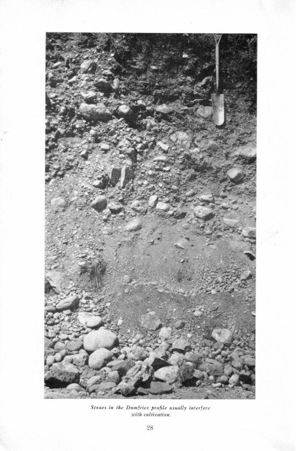
Stones in the Dumfries pioplc u~aiolly ixie;ic:,
with cultivation .
28

Because of the steep slopes Dumfries soils are very susceptible to erosionand should be kept under a cover of trees or grass for as long as possible . Thenatural vegetation in woodlots consists of sugar maple, silver birch, beech, poplarand basswood .
A typical profile of a Dumfries soil possesses a dark grey A, layer, 3 to 4inches thick . This A, layer is stony, neutral in reaction and has a granularstructure . The Az is yellowish brown and becomes lighter in colour with depth.The B horizon is dark brown and contains more clay than the soil above orbelow it . The parent material that occurs at depths of 18 to 24 inches is a lightgrey calcareous, stony sandy loam. This is a Grey-Brown Podzolic soil .
The Dumfries soils have been cleared and cultivation has been attemptedin some areas . In the main these soils are too stony and too steep for cultivationbut can be used as pasture land . The existing pasture lands are often weedy andgrowth of grasses is sparse in many areas . These pastures could be improvedeconomically by spraying to get rid of the weeds. The native grasses would thenbe able to increase in number and vigour . Care should be taken to prevent theovergrazing of pasture lands. As soon as the pasture shows signs of being over-grazed the livestock should be removed and no further grazing be permitteduntil the grass has had a chance to recover. The grass should be permitted tomake a reasonable amount of growth before winter sets in .
KILLEAN SERIESThe Killean soils occur in association with the Dumfries and occupy about
100 acres. The topography is irregular, gently sloping and the drainage is im-perfect . The slopes are gentle and there is little danger of erosion. The land iscovered with tree vegetation which consists mainly of sugar maple and soft maple.
The profile of Killean loam, the only soil type mapped, is similar to thatof the Dumfries loam except that the horizons are not as well defined and theA, and B horizons are usually mottled . Mottling is the result of slow drainage .
Killean loam is neutral to slightly acid and contains more stones and bouldersthan are usually found in the Killean soils mapped in Southern Ontario.
The small areas of this soil that occur on the island must be considered asnon-agricultural .
LILY SERIESThe Lily soils are unimportant soils on Manitoulin Island both from the
standpoint of acreage occupied and their uses for agricultural purposes. Theyoccupy a total mappable area of about 100 acres and are to be found associatedwith the Dumfries soil . Although the Lily soils are developed on materials similarto those of the Dumfries they are poorly drained and the topography is depres-sional . They are very stony and possess both granite and limestone boulders atthe surface and throughout the soil profile .
A typical soil profile possesses a very dark greyish brown A, horizon about6 inches thick. This horizon is very stony and is alkaline in reaction . The Ghorizon is greyish brown, stony and very mottled and is more alkaline than theA, horizon. The parent material that occurs at depths of 20 to 24 inches is acalcareous, very stony sandy loam .
29

The large number of stones and boulders on the soil surface and poordrainage exclude the use of these soils for cultivated crops . However they couldbe used for growing certain tree species. Present wooded areas are made upmainly of elm and white cedar.
VASEY SERIESThe Vasey soils are stony and have developed from a till that has been
derived from Precambrian granites and limestones of a more recent age. Thesesoils occupy a total area of 13,800 acres or 2.0 per cent of the surveyed area . Thelargest areas of Vasey soils are to be found in the eastern and western ends ofthe Island. These soils occur in other parts of the Province particularly innorthern Simcoe County .
The topography of the Vasey soils is somewhat more rugged than is char-acteristic of some of the other soils on the Island . In general slopes are moderateover most of the land but steeper slopes are found where it is drumlinized. Allof these soils are well drained but associated imperfectly and poorly drained soilsare to be found in the depressions.
Soil development shows some of the characteristics of both the BrownPodzolic Great Soil Group and of the Grey-Brown Podzolic soils. The upperpart of the soil profile is characteristic of the former but a fairly well developedtextural B horizon is always present at a depth of about 30 inches . The soilprofile possesses a dark greyish brown A1 horizon which rests on a dark brownB horizon. The B horizon becomes lighter in colour with depth and is underlainby a very pale brown horizon which is considered to be the remaining portionof the AZ of the original Grey-Brown Podzolic soil . It rests on a yellowish brownB horizon. This B horizon contains more clay than the layers above or below it.
Most of the Vasey soils on Manitoulin Island are non-arable because of thelarge number of stones and boulders on the soil surface. However they are usedto a considerable extent for grazing purposes and in some instances, where thestones have been removed, are used to grow spring grains and hay.
These would appear to be ideal soils for forest lands. The sugar maple isthe dominant species and is associated with a great variety of other trees suchas silver birch, basswood, poplar, beech and spruce . The use of the stony Vaseysoils as permanent forest sites should be encouraged .
HOWLAND SERIESThe Howland soils are found in association with the Vasey soils and have
developed on the same kind of materials. The topography is very gently slopingand the drainage is imperfect. Most of the land is covered by trees and maple,elm, silver birch, poplar, spruce and hemlock are the chief species.
Howland loam (5,900 acres), Howland loam - shallow phase (2,100 acres)and Howland sandy loam (100 acres) are included in the series and make up1 .1 per cent of the surveyed area . The profile is similar to that of the Vasey soils
except that the horizons are not as well developed and reddish mottles occur in
the parent materials, the B horizons and the A2. Stones are numerous both on
the surface and throughout the soil mass .
30

The soils of the Howland series that occur on the Island are non-arable .However they are used for grazing purposes although they are stony and, forthe most part, covered with trees. Because of the stony nature of these soils itis doubtful that any program of pasture improvement would be economical .These would appear to be suited to the growing of trees and the use of Howlandsoils for forest sites should be encouraged .
LYONS SERIESThe Lyons soils occupy 5,800 acres or almost one per cent of the whole area
and are usually found in association with the Vasey and Howland soils . Thetopography is level. Although the surface soil is strewn with stones and bouldersof dominantly igneous origin, some of the stones are derived from adjacentformations of limestone and calcareous shale.
The soil drainage is poor as a result of slow run-off. Most of the land iscovered with trees and black spruce, alder, poplar, cedar, hemlock and elmare the most common species.
Lyons loam (3,500 acres) has the characteristics o£ the Dark Grey GleisolicGreat Soil Group and consists of a very dark grey to black A1 horizon about sixinches thick followed by a mottled drab grey G horizon. The G horizon has amassive structure and is alkaline in reaction and rests on stony calcareous sandyloam till .
A profile of Buzwah clay loam .
31

Where the soil is between one foot and three feet deep over limestone bed-rock it has been mapped as Lyons loam - shallow phase . Twenty-three hundredacres of this soil have been mapped on the Island .
Because of excessive stoniness and poor drainage the Lyons soils on Mani-toulin Island should be considered as non-agricultural .
BUZWAH SERIESThe Buzwah soils are important because they are deep and can be used
in some areas for the growing of crops . These soils range from very to moderatelystony . _ The Buzwah soils are developed from a till that has been derived fromdolomitic limestone and reddish calcareous shale .
Soils included in the Buzwah series are the clay loam (22,400 acres), siltyclay loam (2,100 acres) , clay loam - shallow phase (2,200 acres) and silty clayloam - stony phase (8,500 acres) . They occupy a total area of 35,200 acres or5 per cent of the Island . The largest area of the Buzwah soils is to be foundwest of Wikwemikong but other areas of considerable size occur near LakeManitou, Lake Kagawong, Ice Lake and on Barrie Island .
The topography of the Buzwah soils is smooth, moderately sloping exceptwhere they occur near the shores of Manitowaning Bay . Here there is a relatively
Landscape showing the undulating surface of the Buzwah soils .
32

sharp drop to the water's edge and slopes are steep. All of these soils are welldrained but small areas of imperfectly and poorly drained soils are to be foundin the depressions .
The soil profile has a dark greyish brown A1 horizon about 2 inches thick .This layer has a granular structure and is slightly acid in reaction. The AZ horizonis yellowish brown and becomes lighter in colour with depth. This horizonis also acid to a depth of approximately 16 inches . At this depth a well developeddark brown B horizon is present that contains more clay than the soil above orbelow it . This horizon has a nuciform structure and is neutral in reaction .
The parent material that occurs at depths of 20 to 24 inches is a pinkishgrey, calcareous, stony, clay loam till and a pale brown, stony loam till whichmay be layered or mixed. This kind of soil development may be considered tobe a weak form of Grey Wooded.
Most of the Buzwah soils are non-arable because of stoniness . These soilsare used for grazing purposes and although they are stony they serve some usefulpurposes as grazing land . These would appear to be ideal soils for the growthof forest tree species. Sugar maple and silver birch are the dominant species andare associated with a great variety of other trees such as beech, poplar, basswood,elm, spruce and hemlock.
Less stony areas of these soils occur on Barrio Island and near Ice Lake andare used for the growing of hay, alfalfa, clovers, oats and barley . Yields of timothyand clover hay average 11/2 to 2 tons per acre and barley and oats average 30 to40 bushels to the acre . Usually the crops grown are fed to beef cattle thus pro-viding manure which is used to good advantage on the land.
LEECH SERIESThe soils of the Leech series are moderately fine textured Grey Wooded soils
that have developed on the same calcareous till as the Buzwah soils . They occupy11,500 acres or 1.7 per cent of the total land area and occur in association withthe Buzwah soils. The topography is smooth gently sloping and there is littleor no danger of erosion because water run-off is slow. The tree cover on the virginsoils consists mainly of poplar, elm, cedar, silver birch and hemlock. These soilsare imperfectly drained but small areas of Phipps soils are found in the depres-sions.
Soil types included in the Leech series are clay loam and silty clay loam .In some areas, particularly on the eastern side of Lake Kagawong, the soilmaterials are only I to 3 feet deep over the limestone bedrock and a shallowphase of these soils has been mapped. Surface stones are sometimes numerousin the silty clay loam and in such very stony locations a stony phase was mapped.
The soil profile is like that of the Buzwah soils but is not as well developed .Red and yellowish mottles occur in the B horizon and parent material of thesoils giving evidence of imperfect drainage .
The less stony fields and fields where the stones have been removed are suitedto most of the crops grown in the area . Clovers, timothy, oats, and barley producegood yields . Legume, grass crops should be used in rotation with coarse grainsto provide feed for livestock and a source of manure . Fertilizers should be used
3 3

to improve soil fertility. Much of this land is non-arable due to stoniness and isused for woodlots or pastures .
PHIPPS SERIESThe Phipps soils often occur in small areas scattered throughout the Island
but some larger areas are located at the bases of the many limestone bluffsoccurring in the area . They occupy a total area of 4,200 acres and are some ofthe less important soils on the Island .
The topography is depressional although where the soils occur near thelimestone ridges the land is gently sloping. The drainage is poor due to thevery slow run-off or the seepage from adjacent higher land . Most of the soilsare forested, cedar and poplar being the dominant species present.
The Phipps series consists of the clay loam and silty clay loam types . Clayloam - shallow phase and silty clay loam - stony phase are also mapped.
A typical soil profile possesses a black A7 horizon about six inches thick.This horizon has a nuciform structure and is neutral in reaction . The G horizonis grey and contains many yellow and reddish mottles. The parent material thatoccurs at about 20 inches is the same as that of the Buzwah.
The Phipps soils are non-arable due to stoniness and poor drainage andare used for trees or rough pasture.
B. Soils Developed on Outwash MaterialsDONNYBROOK SERIES
The Donnybrook soils are developed on calcareous, gravelly outwash con-taining a large number of stones and boulders . They occupy a total area of4,300 acres and may occur on long narrow ridges known as eskers, on beaches oron kames. These soils occur under similar situations in other parts of the Provinceparticularly in Huron and Bruce Counties.
The topography of the Donnybrook soils is rugged and consists of irregularsteep slopes . Moisture percolates easily through the coarse materials and runsrapidly off the steep slopes . All of these soils are therefore well drained. Thedominant trees found on areas of these soils that are still forested are sugarmaple and beech. Red pine occur on the sandier locations.
The soil profile is characteristic of the Grey-Brown Podzolic soils and pos-sesses a dark greyish brown A1 horizon about 4 inches thick . The A= horizon isyellowish brown and becomes lighter in colour with depth. This horizon is 6to 12 inches thick, slightly acid in reaction and has a weak platy structure . Adark brown B horizon that contains more clay than the soil above or below itoccurs below the subsurface layer. The parent material occurs at about 18 inchesand is a very pale brown gravelly, calcareous outwash. These materials are notuniform, and small pockets of sand or calcareous loam till may be present.
The Donnybrook soils that occur on Manitoulin Island are non-arable soils .However they are used for grazing purposes and although the topography isrough and they have a low moisture holding capacity they provide roughage forlivestock for a part of the growing season . Because of the stony nature of thesesoils and the rugged topography any program of pasture improvement would bedifficult .
34

These soils would appear to be ideal sites for the growth of some forest treespecies and their use for this purpose should be encouraged .
BRIDGMAN SERIES
The Bridgman soil occurs on a ridge in the vicinity of Providence Bay whereit occupies a total area of 1,700 acres. This soil occurs in areas of drifting sandwhere the dark surface soil has been entirely removed by wind and water erosion.Areas mapped as Bridgman sand include eroded areas and areas where materialshave accumulated.
The soil profile shows little or no development. The surface layer is eithereroded away or buried by the moving sand . The remainder of the profile consistsof loose, coarse and medium sand with some gravel and boulders, which gradesin colour from yellow to very pale brown from the surface to the parent materials.
Bridgman sand should be considered as a non-agricultural soil . In its presentcondition the sand carried from the eroded areas by the wind accumulates oncropland, pastureland, and woodland . All "blow-outs" should be reforested andfenced from livestock.
A Wendigo sandy loam profile.
35

WENDIGO SERIES
The soils of the Wendigo series occupy 23,600 acres or slightly over 3 percent of the total land area and are often found near a body of water . They areformed from very pale brown, water-worked, stratified medium to fine sands .
The soils have a smooth gently sloping topography and are well drained .A large percentage of the precipitation, seeps rapidly through the soil, due tothe porous nature of the materials . The original vegetation probably consistedmostly of red pine however, much of the pine has been cut and remaining wood-lots are made up-of silver birch, basswood, and poplar with some maple, spruceand fir. Most of the land which at one time was cleared and cultivated hassubsequently been abandoned and it is now covered with grasses, weeds andsome trees .
Three soil types of the Wendigo series are mapped on Manitoulin Island,namely Wendigo sandy loam, Wendigo sand and Wendigo fine sandy. loam .
In undisturbed locations the profile has a very dark grey strongly acid Aohorizon about 1 inch thick made up of decomposed needles, leaves and twigs.The AZ horizon is white, strongly acid and about 2 inches thick . The B horizonis yellowish brown and becomes lighter in colour with depth . The parent materialthat occurs at depths of 24 to 30 inches is non-calcareous sand. Soils with thiskind of development are classified as Podzols .
The cultivated surface soil of the Wendigo soils is generally brownish greyin colour, very loose and contains very little organic matter and plant nutrients .Areas mapped as Wendigo fine sandy loam are sometimes underlain by calcareousvery fine sand or silt loam at depths of five to six feet.
Only a small percentage of the Wendigo soils is under cultivation . Mostof the land is in pasture or trees . However, an area near Gore Bay is beingcultivated and fair yields of oats and hay are obtained when the soil is carefullymanaged . In general hay and grain yields are low due to the low fertility, lowmoisture holding capacity and the acid nature of the soils .
In the management of the Wendigo soils for crop production the state ofthe organic matter content must be given major consideration . The organic mattercontent should be increased and maintained by heavy applications of barnyardmanure . The organic matter not only adds nitrogen, but also increases themoisture holding capacity of the soil . Lime is required for most crops, particu-larly clovers . The amount to add is best determined by a soil test. Completecommercial fertilizers are required for the production of most crops . The rateo£ application and the type of mixture used varies greatly with the crops grownand the amount of manure used .
When there is sufficient moisture and the soils are heavily fertilized certainspecial crops such as potatoes and raspberries may be grown . However it isunlikely that the Wendigo soils will be intensively cultivated due to the highcost of fertilizer and the danger of crop failures because of lack of moisture .
MALLARD SERIES
The Mallard soils occupy a total area of 3,500 acres on Manitoulin Island,and are not of any great importance as agricultural soils . Their materials consist
36
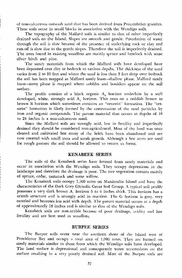
of non-calcareous outwash sand that has been derived from Precambrian granites .These soils occur in small blocks in association with the Wendigo soils .
The topography o£ the Mallard soils is similar to that of other imperfectlydrained soils on the Island . Slopes are smooth and gentle . Percolation of waterthrough the soil is slow because of the presence of underlying rock or clay andrun-off is slow due to the gentle slopes. Therefore the soil is imperfectly drained.The trees found in existing woodlots are mainly spruce and hemlock with somesilver birch and pine .
The sandy materials from which the Mallard soils have developed havebeen deposited over clay or bedrock to various depths . The thickness of the sandvaries from 2 to 10 feet and where the sand is less than 3 feet deep over bedrockthe soil has been mapped as Mallard sandy loam-shallow phase. Mallard sandyloam-stony phase is mapped where cobbles and boulders appear on the soilsurface.
The profile consists of a black organic AO horizon underlain by a welldeveloped, white, strongly acid A= horizon . This rests on a reddish brown tobrown B horizon which sometimes contains an "ortstein" formation. The "ortstein" formation is likely formed by the cementation of the sand particles byiron and organic compounds. The parent material that occurs at depths of 18to 24 inches is a non-calcareous sand .
Since the Mallard soils are strongly acid, low in fertility and imperfectlydrained they should be considered non-agricultural . Most of the land was oncecleared and cultivated but many of the fields have been abandoned and arenow covered with small trees and scrub growth . Although a few acres are usedfor rough pasture the soil should be allowed to return to forest .
KENABEEK SERIESThe soils of the Kenabeek series have formed from sandy materials and
occur in association with the Wendigo soils . They occupy depressions in thelandscape and therefore the drainage is poor . The tree vegetation consists mainlyof spruce, cedar, tamarack and some willow .
The Kenabeek soils occupy 7,500 acres on Manitoulin Island and have thecharacteristics of the Dark Grey Gleisolic Great Soil Group. A typical soil profilepossesses a very dark brown A, horizon 5 to 6 inches thick . This horizon has acrumb structure and is strongly acid in reaction . The G horizon is grey, verymottled and becomes less acid with depth. The parent material occurs at a depthof approximately 18 inches and is similar to that of the Wendigo soils .
Kenabeek soils are non-arable because of poor drainage, acidity and lowfertility and are best used as woodlots.
BURPEE SERIESThe Burpee soils occur near the southern shore of the Island west of
Providence Bay and occupy a total area of 1,000 acres. They are formed onsandy materials similar to those from which the Wendigo soils have developed .The land surface is depressional and consequently water accumulates on thesurface resulting in a very poorly= drained soil . Most of the Burpee soils are
37
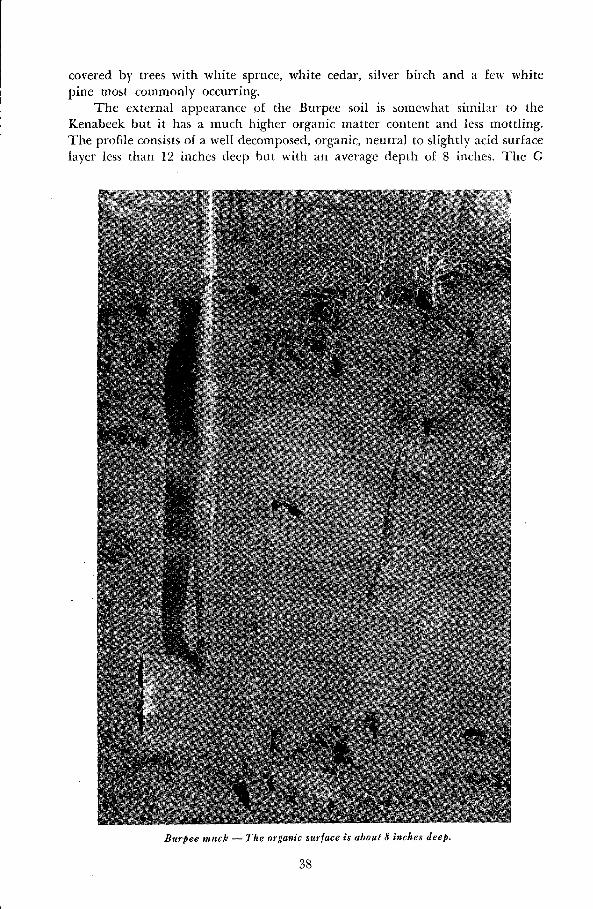
covered by trees with white spruce, white cedar, silver birch and a few whitepine most commonly occurring.
The external appearance of the Burpee soil is somewhat similar to theKenabeek but it has a much higher organic matter content and less mottling.The profile consists of a well decomposed, organic, neutral to slightly acid surfacelayer less than 12 inches deep but with an average depth of 8 inches . The G
8urpee muck -The organic surface is about 8 inches deep .
38

horizon is drab greyish brown slightly mottled and neutral in reaction . Theparent material is non-calcareous sand.
The Burpee soil is non-agricultural because of very poor drainage and isused for growing trees.
BURFORD SERIESThe Burford soils occupy a total area of 14,000 acres or 2.0 per cent of the
Island . The largest of these areas are to be found along the south shore of SmithBay, near the east shore of West Bay and along the west shore of ManitowaningBay. Smaller blocks occur in other parts of the Island .
The topography is smooth, gently sloping except in some places wheresteeper ridges have been formed by wave action . All of these soils are well drainedbut small areas of other imperfectly and poorly drained soils are to be found inthe depressions. Most of the land is forested and sugar maple, silver birch, poplarand spruce are the chief species found as well as a variety of other trees such aspine, oak, ironwood and basswood .
A Burford loam profile. Note the wavy B horizon .
The Burford series has been classified into two types; loam and sandy loam .Two hundred acres of the Burford loam is underlain by bedrock at depths ofless than three feet and these areas are mapped as Burford loam - shallow phase.
Although the soil profile is Grey-Brown Podzolic it is not as well developedas that of the Burford soils found in more southerly parts of the Province . Itconsists of a thin, medium acid, dark greyish brown A, horizon underlain by ayellowish brown A, horizon which becomes lighter in colour with depth. Thisis followed by a dark brown, slightly acid to neutral B horizon which contains
39

more clay than the soil above or below it. The B horizon is wavy and as a resultthe depth of the solum varies considerably . This profile rests on calcareous, palebrown stratified gravel and has no unaltered parent material . Stones and graveloccur in varying amounts throughout the profile .
Although the Burford soils are fairly well suited to the growing of generalfarm crops and certain specialized crops a large part of the land remains undertree cover. In some locations the lack of cultivation of the land is likely due tothe presence of large numbers of stones and boulders strewn about the surfaceof the soil .
Where the land is cultivated, yields of grasses and clovers are good . Alfalfaproduces well due to the abundance of lime and the good drainage of the soils .However, these soils are low in fertility and have a low moisture reserve and thebest yields are obtained only in seasons of adequate rainfall and when the soilsreceive sufficient amounts of commercial fertilizers .
BRISBANE SERIES
The Brisbane soils occupy a total area of only 600 acres on the Island andare therefore of minor importance agriculturally . They are situated on the verygentle slopes that occur in the depressions of the Burford soils . The drainage isimperfect because of seepage of water from the surrounding higher land . Theloam is the only soil type in the Brisbane series mapped on the Island .
The soil profile possesses a dark coloured AI horizon which is often thickerand contains more organic matter than the A1 horizon of the Burford soils . Thishorizon has a granular structure and is slightly acid in reaction . The AZ horizonis mottled, yellowish brown and is more acid than the Al . A brown, mottled Bhorizon occurs at a depth of about 12 inches which contains more clay than thesoil above or below it but is less well developed than the similar horizon in theBurford soils . This profile rests on stratified gravel similar to that on which theBurford profile rests . However, as with the Burford, this gravel material is notthe same material from which the profile developed .
This kind of soil development may be considered to be a weak form ofGrey-Brown Podzolic or, on the other hand, a transitional form from Grey-BrownPodzolic to Dark Grey Gleisolic .
Most of the land is forested and tree species such as poplar, balsam andspruce are most commonly found. Cleared areas are used for rough pasture. TheBrisbane soils on Manitoulin Island have not been cultivated because of slowdrainage and stoniness .
GILFORD SERIES
The soils of the Gilford series occupy a total area of 1,900 acres and usuallyoccur in small blocks that are found in the depressional areas among the Burfordsoils . They are poorly drained because water accumulates in the depressions andremains for a large part of the year. The soils are stony and both granite andlimestone boulders occur at the surface and throughout the soil mass . Most ofthe Gilford soils are wooded and tree species such as elm, soft maple, poplar,spruce and willow most commonly occur.
40

Gilford loam (1,600) and Gilford sandy loam (300) are the types in theGilford series mapped on the Island .
A typical soil profile has a black A1 horizon 6 to 8 inches thick. This horizonhas a granular structure and is slightly alkaline in reaction . The G horizon isgreyish brown, very mottled and has a blocky structure . This rests on calcareous,stratified gravel .
The Gilford soils that occur on the Island are non-arable and are used fortrees and rough pasture. Because of the poor drainage and the stony nature ofthese soils it is doubtful that any program of land improvement would be prac-tical . These soils are best used for forestry .
C. Soils Developed on Sands Underlain by Silty ClayBUCKE SERIES
The Bucke soils occur in small blocks in the vicinity of Gore Bay andMindemoya and have been mapped in other parts of Northern Ontario, par-ticularly in the southeastern part of the Temiskaming District . They occupy atotal area of 2,100 acres or 0.3 per cent of the area of the Island . These soils havedeveloped from non-calcareous sand that has been deposited to a depth of lessthan 3 feet over calcareous silty clay .
The topography of the Bucke soils is not as rugged as many of the otherwell drained soils on the Island . In general, slopes are smooth and gentle exceptfor an area south of Gore Bay where they are more rolling . Water percolatesrapidly through the sandy materials until it reaches the less permeable silty clay .At this point it runs over these finer materials and into the drainage waters . Muchof the land has been cleared but where trees remain silver birch, pine, sugarmaple and beech are the main species found.
Except for the presence of silty clay at depths of 3 feet and less and theabsence of sand parent material the Bucke profile resembles that of the Wendigo.Sandy loam and fine sandy loam soil types are mapped on the Island . A typicalvirgin soil profile has a thin very dark grey A� horizon which is composed of leaflitter and roots . The Al horizon is light grey and is strongly acid in reaction. Thishorizon is about 2 inches thick and rests on a yellowish brown B horizon thatbecomes lighter in colour with depth. The B horizon is underlain by varved,calcareous silty clay that is unlike the material from which the profile developed .
In some locations, where the soil surface has been disturbed, a thin, darkgrey mineral layer is found below the organic surface layer, and where the soilhas been cultivated the surface and subsurface have been more or less intermixedwith the upper portion of the subsoil resulting in a greyish brown surface layerabout six inches thick.
The Bucke soils are dry, strongly acid and of low fertility . Where they arecultivated the Bucke soils are used for general farming and sometimes forgardening. Although the natural fertility is low it can be improved considerably .The ability of the soil to retain moisture and plant nutrients can be increasedby plowing down buckwheat or clover . Growers report yields obtained with theuse of some manure but without commercial fertilizer, on the Bucke sandy loam,average 1 to 11/2 tons per acre for hay, 20 to 30 bushels per acre for oats and 150-200 bushels per acre for potatoes. Yields on the Bucke fine sandy loam are some-
4 1
what higher because of its higher natural fertility . Increased yields can beexpected when commercial fertilizer is used . The analysis and rate of fertilizer tobe used depends upon the crop to be grown and the soil test . Lime is necessaryfor the normal growth of clover, especially alfalfa.
OTTERSKIN SERIESThe Otterskin soils are imperfectly drained, occur in association with
the Bucke soils and occupy 3,200 acres of the total land area of Manitoulin Island.They are stonefree soils and consist of medium or . fine sands deposited over siltyclay at depths of 3 feet or less .
The topography is smooth, very gently sloping which is characteristic ofmany of the imperfectly drained soils on the Island . Because of the very gentleslopes water run-off is low. Water percolation is rapid through the sandy materialsin the upper part of the soil but is slowed down considerably when it reachesthe underlying clay . The trees found in existing woodlots consist mainly ofpoplar, spruce and pine . Both sandy loam and fine sandy loam soil types havebeen mapped.
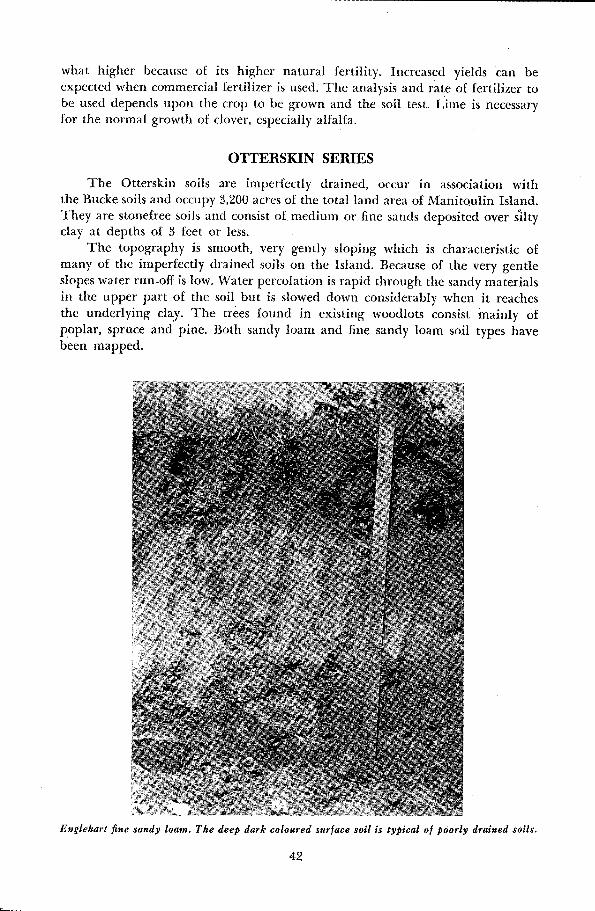
Englehart fine sandy loam. The deep dark coloured surface soil is typical of poorly drained soils .
42
These are acid, leached soils having a Podzol type of soil development. Avirgin profile possesses a very dark grey Ao horizon 2 inches thick. This horizonis composed of raw humus and roots and is strongly acid in reaction. The A,,horizon is light grey and is often more acid than the layer above or below it .The B horizon is yellowish brown and becomes lighter in colour with depth.Unweathered sand parent materials are absent and the profile rests on varved,calcareous silty clay .
Although the average depth of sand over silty clay is 20 inches there isconsiderable variation in the depth of the sand and therefore some variabilityin soil profile . Where the sandy overburden is thin a subsoil horizon is sometimesdeveloped from the silty clay materials and where the sandy overburden is closeto 3 feet deep non-calcareous sandy parent material may occur over the silty clay .
Most of the Otterskin soils are cleared and cultivated and are used forgeneral farming. Hay, pasture and oats are the chief crops grown but yields arelow because of the poor fertility of these soils . Hay yields range from 3/ to 1 ton,oat yields from 20 to 30 bushels and potatoes yield from 100 to 200 bushels per acre .However, these yields can be increased by the use of manure, fertilizer and lime .
Manure should be added to the soil each year and it can be plowed into thesoil during cultivation or applied as a topdressing on hay and pasture crops.The kind and amount of fertilizer to use is best determined by a soil test althoughin general, crops will respond to applications of fertilizers high in nitrogen andphosphorus . Lime is required by the clovers in the hay and pasture mixturesbeing grown on these soils and is best applied the year before seeding down.
ENGLEHART SERIESThe soils of the Englehart series occur in small scattered areas throughout
the central portion of the Island and occupy a total area of 2,000 acres. They aremade up of medium or fine sand which is underlain by silty clay at depths ofthree feet or less . The Englehart soils occur in the depressions of the associatedBucke and Otterskin soils and since they are found in such depressional areaswater accumulates and they are therefore poorly drained. The organic mattercontent of the surface soil is higher than that in the surface of associated soilsfound on the better drained sites .
The soil types occurring in the Englehart series are the fine sandy loamand the sandy loam . These soils are classified as Dark Grey Gleisolic and thesoil profile possesses a black A1 horizon about 6 inches thick . This horizon hasa crumb structure and a strongly acid reaction . The G horizon is mottled, greyand strongly acid and rests on calcareous, silty clay.
The Englehart soils that occur on the Island are non-arable . However, theyare used for natural hay and pasture land and although they are wet they servesome useful purpose as grazing land. Pasture land could be improved by sprayingto kill the weeds that interfere with the growth of the native grasses . These soilsare suited for the growth of certain tree species, especially spruce, cedar andpoplar which are the dominant species found in existing woodlots .
43

D. Soils Developed on Lacustrine DepositsTHWAITES SERIES
The Thwaites soils consist of non-calcareous silt loam one to three feetdeep that is underlain by calcareous silty clay . They occupy a total, area of 3,100acres and occur near the northeastern shore of Lake Kagawong . The topographyis smooth, moderately sloping except near the banks of streams. Here the rapidlymoving water has washed the soil away and steeper slopes have developed .Although percolation of water through the soil. is slow, because. of the finenessof the material's, the -rolling land' provides high run-off and 'a - well drained soilhas
formed .
.
. ` .
.
_ .
' .
.
-
�
.
a
-
. .
The upper part of a virgin Thwaites soil profile °is a Podzol and possessesa thin organic'A, horizon that is very -dark grey in~.coloun and'strongly acid inreaction . The A~ horizon is a white, strongly * acid' layer about 2 inches thickand is underlain by a yellowish brown B horizon. The -B horizon' becomes lighterin colour to a depth of°about is inches. At this point a yellowish brown B horizonof a Grey Wooded soil is present that contains more clay than the soil above it .This profile rests . on:light brownish .grey, calcareous silty clay which is similarto the parent materials of the Gordon soils described on one of the followingpages of this report . This kind of soil development may be considered as atransition from' Grey Wooded to Podzol since * the profile consists of a Podzolsuperimposed on the B horizon of what may be a Grey Wooded soil .
Thwaites silt loam is the only type'mapped . in. the series and is used forgeneral farming. Hay, pasture, oats, and some wheat are grown - and yields arefair. The follow* ing'yields per acre may be considered as averages : hay, 1i/2 to2 tons ; oats, 30 'to 40 . bushels ;- fall wheat, 25 to 35 bushels. Potatoes should besuited to this soil and yields of 300 to 350 bushels can be obtained when adequateamounts of fertilizer are used . Pastures are generally fair but the excess acidityof the soil favours the rapid growth of weeds such as horsetail and: sorrel .
The Thwaites soils can be improved by the application, of manure andcomplete fertilizers to'improve soil fertility and the use of lime to correct soilacidity. In general, crops respond to applications of nitrogen ; phosphorus andpotassium.
'CASEY SERIES
The Casey soils occupy only a small part of the Island and small blocks,covering a total area of 1,000 acres, occur in the central part of the Island . Thesesoils have developed from non-calcareous silt loam that is underlain by siltyclay at an average depth of 24 inches . Slopes are smooth and gentle and thereforewater runs off the soil surface slowly. The imperfect drainage of these soils isthe result of this low run-off as well as slow percolation of moisture through thefine materials . Most- of the Casey soils have been cleared but trees in the remain-ing woodlots are mainly elm, spruce and maple.
Casey silt loam is the only type mapped and except for the presence ofreddish coloured mottles in the subsurface and subsoil and -less well developedhorizons it. i s similar- in appearance to the Thwaites soil .
',This soil is used for general farming and is fairly well suited to growing
most of the crops on the Island . The main crops grown are hay, pasture and oatsall of which are used to feed the livestock on the farms. -Yields are medium to
44

low but could be improved by additions of manure, commercial fertilizer andlime .
EVANTUREL SERIESThe Evanturel soils consist of a stonefree silt loam that has been derived
chiefly from limestones . They occupy a total area of 6,700 acres or approximately1 per cent of the Island area and are found in the vicinity of Lake 1Vlindemoya
A profile of Evanturel silt loam .
and the town of Gore Bay. In general these soils have a smooth, moderatelysloping relief but steep slopes occur in some localities particularly where smallstreams have dissected the land . All of these soils are well drained but smallareas of Earlton and Cane soils are to be found in the depressions .
The silt loam is the only type in the Evanturel series mapped on the Island .However, a shallow phase of the silt loam has been mapped where the depth ofsoil over bedrock was between one and three feet . Where numerous stonesoccurred on the soil surface a stony phase of the silt loam was mapped.
45
A typical soil profile has a< grey -A, horizon 3 inches thick . This horizon hasa granular structure and is medium acid in reaction . The AZ horizon is paleyellowish brown and becomes lighter in colour with depth. A yellowish brownB horizon occurs below the subsurface: at depths of 18 to 24 inches . This horizoncontains more clay than the soil above or below it and also . becomes lighter withdepth.
The parent material that occurs at depths o£ 30 to 36 inches is a palebrown, calcareous silt loam. The kind of development outlined by the abovedescription may be considered to be a weak form of Grey Wooded or on theother hand a transitional form from Grey Wooded to Podzol especially when,in some virgin locations, a Podzol profile has developed in the subsurface ofthe Grey Wooded soil . Although the surface layer is thicker and better developedthan is common for Grey Wooded soils it is assumed that the highly leachedsubsurface and the presence of calcareous materials is associated with the de-velopment of the Grey Wooded characteristics.
Most of the Evanturel soils on the Island have been cleared and are usedto considerable extent for pasture, hay and oats . They are fertile and good yieldscan be obtained when the soils are well managed. Although the Evanturel soilsare productive, manure and phosphatic fertilizer are required to maintain pro-duction at a reasonable level. Yields vary from year to year due to differencesin weather and management. The yield of oats averages 60 bushels per acreand that of hay is about 2 tons per acre .
Evanturel soils are susceptible to erosion and they should be managed insuch a way that excessive soil loss is prevented . It might be wise to keep thesteep slopes under a permanent cover of grass or trees.
EARLTON SERIESThe Earlton soils are relatively important soils on the Island because of
their wide agricultural uses . Like the Evanturel soils they consist of a silt loamlacustrine material that is calcareous . These soils occupy a total area of 11,600acres or 1 .7 per cent of the Island area . The largest area of these soils is to befound in the vicinity of Lake Mindemoya. However, smaller blocks are foundin association with the Evanturel soils . These soils occur under similar situationsin other parts of the Province andwere first found in the New Liskeard-Englehartarea of the Temiskaming District .
The topography is smooth, gently sloping and, as a result, water run-offis slow. The percolation of moisture through the soil is also slow and, therefore,the soil is imperfectly drained . Most of the land has been cleared of trees andis being cultivated. However, species such as sugar maple, elm, spruce, silverbirch and alder are found in the woodlots that remain .
Earlton silt loam and stony or shallow phases of this type are mapped onthe Island . A typical profile has a dark grey A, horizon 3 inches thick. Thishorizon has a granular structure and is medium acid in reaction . The A2 horizonis light grey in colour, 4 to 8 inches thick, mottled and is the most acid layer inthe soil . This horizon is underlain by a light olive brown B horizon that containsmore clay than the soil above or below it . The parent material that occurs atdepths of 24 to 30 inches is the same as that of the Evanturel soils.
46

47
A profile of Earlton silt loam. The surface is thicker than is common in virginlocations .
This kind of soil development may be considered to be Grey Wooded or,on the other hand, a transition form from Grey Wooded to Dark Grey Gleisolic .
The Earlton soils are among the most fertile in the surveyed area . They areused for dairying, livestock raising, and mixed farming and crops such as hay,pasture, spring grains, and wheat are grown. Hay yields average 2 tons per acre .Good stands of red clover have been observed and alfalfa does well when climaticconditions are good. When adequate amounts of fertilizer and manure are addedto the soil the average yield for oats is 75 bushels, for barley is 55 bushels, for fieldpeas is 50 bushels, for fall wheat is 35 bushels and for silage corn is 18 tons peracre . Yields of oats over 100 bushels per acre have been reported . Root crops suchas mangels and turnips do well on this soil and are an excellent cattle feed, butdue to the amount of hand labour required are not extensively grown.
Additions of manure and commercial fertilizer are necessary to maintaincrop production . The use of phosphorus will increase the yields of all crops aswill additions of potassium. If hay crops are emphasized the chemical fertilizershould be applied at the time of seeding down, having applied the manure to thehoed crop previously in the rotation . Experiments show that pasture yields canbe increased over 50 per cent by adding fertilizer .

CANE SERIESThe Cane soils occur in association with soils o£ the Evanturel and Earlton
series and, on ManitOUlin Island, they occupy a total area of 4,700 acres . The per-colation of water through the soil is low and excess water runs off very slowly dueto the flatness of the land . As a result these soils are poorly,drained . Tree speciessuch as spruce, silver birch and alder are found in the woodlots .
Cane silt loam and the stony or shallow phases of this type are mapped onthe Island . The soil profile has a very dark grey A, horizon 6 inches thick . ThisAi horizon is neutral in reaction and has granular structure . The G horizon is avery mottled pale yellow colour, slightly alkaline in reaction and is underlainby a very mottled light yellowish brown subsoil . The parent material that occursat depths of 24 to 30 inches is the same as that of the.Evanturel and Earlton soils .This is typical of a Dark Grey Gleisolic soil .
The land is not reliable for growing most agricultural crops because of poordrainage and as a result much of the land is used for pasture . In order to preventwater-logging of the soil, ditches or drains with good outlets are needed . Surfacedrainage can be improved by ploughing the land up in ridges and leaving a deadfurrow between the ridges . It is then possible for surface water to run from theridges into the furrow and down to the drainage outlet .
The Cane soils when drained, will produce good yields of oats, barley andhay but present yields are medium to low. As a matter of fact during wet seasonsit is often impossible to sow or harvest a crop. When drainage is improved soilfertility must be maintained by additions of manure and chemical fertilizers .
CAMPBELL SERIESThe Campbell soils are stonefree and consist of a calcareous lacustrine de-
posit with a silty clay texture . These soils occupy a total area of -5,500 acres andoccur in small blocks in the central and western portions of the Island . Slopes aresmooth and moderate, much like those of the Evanturel soils . Although the per-colation of moisture through the soil is low because of the impermeability of theclay materials, water runs rapidly off the rolling slopes and the soil is welldrained . This rapid run-off results in the removal of valuable topsoil, partic-ularly where the soil is cultivated and left without vegetative cover . Most o£ theland is cleared but some woodlots remain in which elm arid sugar maple arethe dominant tree species .
Campbell silty clay loam is the only type mapped . A shallow phase of thistype has been mapped where the depth of soil over bedrock varies from 12 to 36inches . A stony phase of the silty clay loam was mapped where numerous stoneswere present both on the soil surface and throughout the soil mass and wherethe soil was both shallow and stony a shallow-stony phase was delineated. Thesoil profile is somewhat similar to that of the Evanturel silt loam but contains agreater amount of clay. The cultivated profile has a dark grey A, horizon about6 inches thick which is underlain by a light grey, medium acid A= horizon . TheB horizon is brown in'colour and contains more clay than the soil above or belowit . This B horizon is neutral in reaction and has a blocky structure . The parentmaterial that occurs at depths of 18 to 24 niches is a calcareous light brownishgrey silty clay. In undisturbed locations a Podzol development consisting of a
48
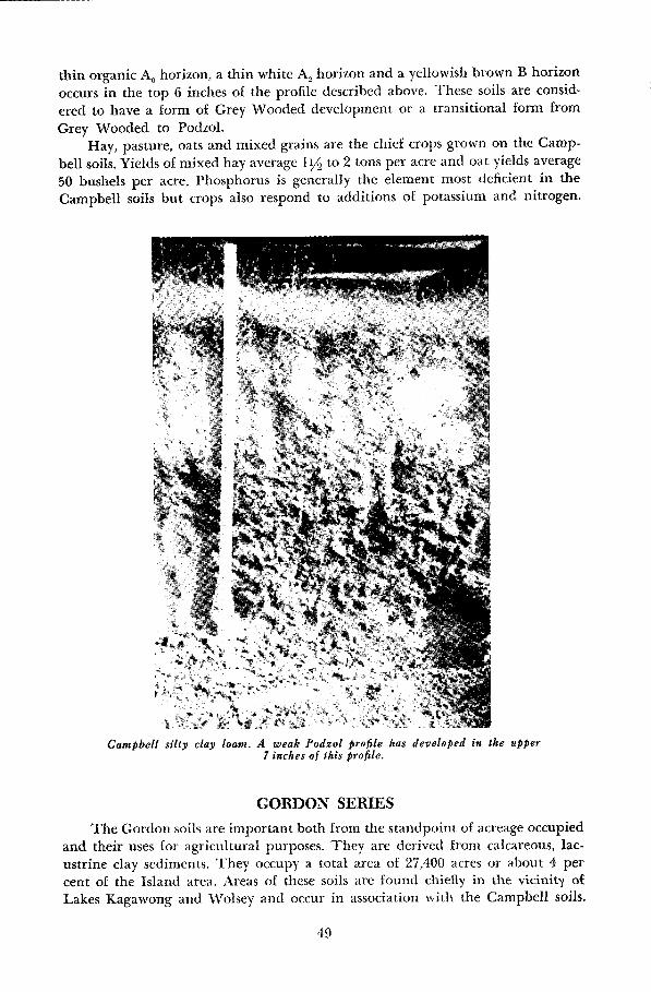
thin organic Ao horizon, a thin white A_ horizon and a yellowish brown B horizonoccurs in the top 6 inches of the profile described above. These soils are consid-
ered to have a form of Grey Wooded development or a transitional form from
Grey Wooded to Podzol .Hay, pasture, oats and mixed grains are the chief crops grown on the Camp-
bell soils . Yields of mixed hay average 11/2 to 2 tons per acre and oat yields average
50 bushels per acre . Phosphorus is generally the element most deficient in theCampbell soils but crops also respond to additions of potassium and nitrogen .
Campbell silty clay loam . A weak Podzol profile has developed in the upper7 inches of this profile .
GORDON SERIESThe Gordon soils are important both from the standpoint of acreage occupied
and their uses for agricultural purposes . They are derived from calcareous, lac-ustrine clay sediments. They occupy a total area of 27,400 acres or about 4 percent of the Island area . Areas of these soils are found chiefly in the vicinity ofLakes Kagawong and Wolsey and occur in association with the Campbell soils .
49

In some parts of the Island they occupy the gently sloping plains between thelong, cigar-shaped till ridges or drumlins .The Gordon soils are imperfectly drained . Percolation through the soil is
slow because of the fineness of the materials . Most of the soils are cleared butsmall woodlots, in which elm are the dominant species, are found in some districts.Silty clay loam is the only type mapped as well as the stony, shallow and shallow-stony phases of this type.
The cultivated soil profile has a dark grey A1 horizon about 6 inches thick .This horizon has a nuciform structure and is slightly acid in reaction . The A?horizon is mottled, very pale brown and is the most acid layer in the profile . It isunderlain by a brown, mottled B horizon that contains more clay than the soil
A profile of Gordon silty clay loam .
above or below it . The parent material that occurs at depths of 15 to 20 inchesis the same as that of the Campbell soils . This kind of soil development is con-sidered. to be Grey Wooded.
The Gordon soils are among the most fertile in the area and are used forlivestock raising and mixed farming. The land is well suited to hay and produces
50

2 to 21/2 tons per acre . Crops such as oats, mixed grains, barley, wheat and foddercorn are grown as well as hay and pasture but the acreages of these crops arerelatively small. When adequate amounts of manure are added to the soil theaverage yield for oats is 55 bushels, for barley is 45 bushels and for winter wheatis 30 bushels.
Although these soils are quite productive they are low in phosphorus andorganic matter . Additions of barnyard manure will help to maintain the organicmatter content and phosphorus levels can be increased by using chemical fertilizershigh in that element.
The stony phase of Gordon silty clay loam is generally too stony to cultivateand is used for rough pasture. The stones could be removed by heavy machinerybut this may prove to be uneconomical . The shallow phase tends to be droughtyand the growth of roots is restricted for some plants .
WOLSEY SERIESThe Wolsey soils are the poorly drained soils associated with the Campbell
and Gordon soils and are derived from the same kind of soil material . Theyoccupy a total area of 11,500 acres or 1 .6 per cent of the Island area . The drainageis poor because the percolation of the water through the fine soil materials isslow and excess water runs off very slowly because of the flatness of the land .Water collects and tends to remain at or near the surface for a large part of theyear. The tree cover in the woodlots consists mainly of elm, alder and spruce .
Silty clay loam is the only soil type mapped but this type has been subdividedinto stony, shallow and shallow-stony phases. The cultivated surface of the soil pro-file is a very dark grey, moderately friable to hard, slightly acid silty clay loam .This is underlain by a very mottled dark greyish brown G horizon which becomeslighter in colour and more alkaline with depth . The pale greyish brown, calcar-eous, silty clay parent materials that occur at depths of 15 to 20 inches are thesame as those of the Campbell and Gordon soils .
The Wolsey soils are fertile and produce good yields of hay and springgrains, if climatic conditions are favourable . Hay yields of 21/2 to 3 tons havebeen reported . Excess moisture in the spring retards planting and a wet fallprevents harvesting on these flat poorly drained soils . These soils should beworked under optimum moisture conditions for if they are worked when too wetthey puddle and bake on drying, which has a poor effect on the growing crop .If the soils are cultivated when too dry they will remain too lumpy for a satis-factory seed bed.
Excess water can be removed by a system of open ditches or by under drain-age. The most efficient system is by under drainage . However the cost of instal-lation of a good tile drainage system is high, and monetary returns from thecrops grown may not be great enough to make it profitable .
Yields on the Wolsey soils can be increased by additions of phosphatic fer-tilizers and barnyard manure . The stony phase of Wolsey silty clay loam is toostony for cultivation and is best used for trees or rough pasture.
5 1

PIKE SERIESThe Pike soils have developed partly on lacustrine deposits and partly on
residual material derived from weathered grey calcareous shale. They occupy atotal area of 1,800 acres and are found south of Little Current in the vicinity ofBass and Pike lakes.
The topography is very rugged and slopes are steep. Surface run-off istherefore rapid and much of the surface soil has been eroded .
Pike clay and Pike clay - stony phase are two separations made in this series .The profile horizons are not as well defined in these soils as they are on otherwell drained soils on the Island . This may be due to the slight percolation ofwater through the profile and hence a lessening of the movement of minerals,clay, and humus within the profile. However, the soil profile has a light brownishgrey A1 horizon 2 inches thick which is underlain by a light grey A, horizon. Thissubsurface layer has nuciform structure, very plastic consistency and is slightlyacid . The B horizon is mottled, yellowish brown and contains more clay thanthe soil above it . The parent material that occurs at depths of 14 to 18 inchesis a calcareous grey clay . This kind of soil development may be considered to beweakly developed Grey Wooded or a transitional form from Regosolic to GreyWooded .
The gentle slopes of these soil areas are used for pasture and the steep slopesare kept under a cover of trees and grass . Pasture should not be overgrazed orgrazed during periods of excess moisture . The use of Pike soils as permanentforest sites should be encouraged .
BASS SERIESThe soils of the Bass series consist of Bass clay and Bass clay - stony phase and
they are derived from materials similar to those of the Pike soils. They occupy atotal area . of 1,100 acres . Since these soils occupy the depressions associated withthe Pike soils the drainage is slow . and water accumulates readily.
The soil profile is similar to that of the Pike except that it is not as welldeveloped and is mottled . A typical soil profile has a dark grey A, horizon 3inches thick underlain by a pale brown, mottled A: horizon. The B horizon is amottled light yellowish brown colour and contains more clay than the soil aboveit. The parent materials that occur at depths of 12-15 inches are the same asthose of the Pike soils .
Approximately half of the area occupied by Bass clay is under cultivationand is used for general farming. The remainder of the Bass soil is forested andspecies such as elm and spruce commonly occur. Bass soils are moderately toslightly acid, fertile, but very difficult to handle since they contain more claythan most of the soils in the district. Ploughing and other cultivation practicesrequire much power and can be carried out only when the land has an optimumamount of moisture .
The maintenance of good structure is of prime importance on this soil .Apart from cultivating at proper moisture conditions, the granular structure canbe maintained or improved by draining, by liming and by generous addition oforganic matter .
52

Mixed hay, pasture, oats and mixed grains are grown and although no defi-nite data have been obtained on the yields of the different crops the followingestimates may be given : mixed hay 1 to 1 V2 tons per acre ; oats 30 to 40 bushelsper acre .
PERCH SERIESThe Perch soils are the poorly drained soils associated with the Pike and
Bass soils and are derived from the same kind of parent material . This smooth,very gently sloping land occupies a total area of 1,500 acres . Water movementover the surface and through the soil is very slow and, as a result, water accumu-lates on the surface during periods of high moisture . Elm is dominant in thewoodlots and small numbers of spruce and alder also occur.
Perch clay and Perch clay -- stony phase are both mapped. The soil profileconsists of a very dark grey A, horizon 6 inches thick that is sticky when wet andvery hard when dry. The G horizon is brownish grey, very mottled, massivelayer that becomes greyer with depth. The parent material that occurs at depthsof 12-16 inches is calcareous mottled grey clay .
The soil where cultivated, is commonly used for general farming and theprincipal crops grown are pasture and mixed hay. Yields are dependent on theproper amount of rainfall .
A Perch clay profile .
53

Drainage problems are serious on the Perch soils since the clay is compar-atively impervious and the land is flat . Rounded ploughing or under drainagecan be used to get rid of excess water as quickly as possible .
Great care should be taken to keep the cultivated soil in good physical con-dition . Additions of organic matter will help in maintaining soil structure.
E. Shallow SoilsFARMINGTON SERIES
The Farmington soils are shallow and consist of a till that is derived fromlimestone and is less than one foot deep . In some areas the underlying limestonebedrock appears at the surface and the till can only be seen in the crevasses of therock . These soils occupy a total area of 429,200 acres or approximately 60 percent of the Island .
The topography is level except where it is broken by rocky ledges. Theseledges are very steep and form the perpendicular cliffs common in many partsof the Island . The soils are well drained and are droughty during the summermonths .
Within the areas mapped as Farmington are small areas of somewhat deepersoils and soils of poorer drainage . The deeper soils rarely exceed a depth of 20inches and have developed from the same calcareous till as the Farmington soils.They commonly have a weakly developed AZ horizon between the A1 and Bhorizons described for the Farmington soils. These deeper soils and soils of poorerdrainage occur to such a small extent that they cannot be separated except on amuch more detailed survey. The profile varies . In very shallow soils there is sel-dom more than a thin organic layer over the bedrock but in the somewhat deeper
Much of the Island consists of flat rock plains covered by a thin layer of soil.
54

soils the dominant horizon is a brown to dark brown subsoil layer just belowthe surface soil . The parent material is a calcareous, stony loam. This kind ofsoil development may be considered to be Brown Forest .
Forestry and grazing are the two chief uses of this soil . Poplar is commonwhere there are a few inches of soil . In the deeper crevasses hard maple growsvery well . In the original forest, maple was doubtless the dominant tree specieson the shallow limestone plains . Since clearing, and the subsequent loss of organicmatter and soil, the areas able to produce maple have been considerably reduced.Reforestation with maple would appear to be highly desirable in many sections .
Large areas are devoted to grazing. This appears to provide the farmer witha living, providing that he has sufficient acreage or can supplement his incomefrom other sources. For crop production this soil must be considered a marginaltype . Lack of moisture reduces the efficiency of methods of improving soil fertilitywhich have proven economical on other types. Large investments in fertilizerswould not be economical . However, clovers can be grown with fair success infavourable seasons. By growing clovers frequently and using all available farm-yard manure and crop residues, a fair state of fertility can be maintained . Limingis not necessary.
The best planned economy for these lands would appear to be the establish-ment of comparatively large holdings for a single operator which would belargely used for grazing and forestry . The houses of the operators should befairly well centred in a community so as to provide transportation and socialfacilities at a minimum of cost . Deeper pockets of soil could be used advanta-geously to provide for household needs. To a degree this is the present situationin many sections, as many o£ the farm buildings have been abandoned and theland taken over by neighbours . This has resulted in a very scattered settlement .
KAGAWONG SERIES
The Kagawong silt loam occupies a total o£ 5,600 acres. This soil is developedon gently undulating to level silt loam materials of less than one foot in depthover limestone bedrock. Most of these materials, although lacustrine in origin,are somewhat stony. The drainage is good to excessive.
Commonly the profile consists of a dark grey surface layer 4 inches thick.This surface layer has a granular structure and is neutral in reaction . The subsoilis yellowish brown, slightly alkaline and has a weak nuciform structure. The palebrown, calcareous parent material only appears where the soil is 8 to 11 inchesdeep over the bedrock. In a few locations, where the soil approaches 12 inchesin depth, a very thin leached subsurface layer occurs . This kind of soil develop-ment is Brown Forest or a transitional form from Brown Forest to Grey Wooded.The Kagawong silt loam is used for grazing in much the same way as the Farm-ington . However, greater content of fine materials gives the Kagawong a highermoisture reserve and level of natural fertility than the Farmington .
LITTLE CURRENT SERIES
Little Current clay occupies a total area of 1,700 acres near the town of LittleCurrent. It consists of less than 12 inches of clay over calcareous, shale bedrock.
5 5

The topography is level and the drainage is good . The profile is similar to thoseof the other shallow soils ranging from a thin organic layer over the rock to aprofile having a very dark grey surface soil followed by a very dark greyish brownsubsoil layer. This subsoil layer is slightly alkaline and has a massive structure.The soil appears to have weathered directly from the shale bedrock, and is con-sidered to be residual . It has a Brown Forest type of profile development.
The soil is used for grazing. Grazing should not be permitted during periodsof excess moisture since plants are punched out and killed by the hoofs of - theanimals and soil structure is destroyed.
F. Organic Soils
MUCKMuck soils occupy about 3 per cent or 22,700 acres of the surveyed area .
These organic deposits are formed mainly by the decomposition of grasses, sedgesand wood debris . The black organic deposit is well decomposed and rests onvarved clay, silt loam, sand or bedrock. The muck varies from 18 inches to 10feet deep but it is generally about 3 feet deep .
Few of the muck soils are cultivated and most of them are covered by treevegetation composed of spruce, willow and alder. In Manitoulin Island mucksoils have not been used to any extent for vegetables because of the long, coldwinters. The muck may be used as a source of organic matter for mineral soils.
G. Miscellaneous Soils
MARSHAreas that are covered by water for a long time and lack a well developed
profile are mapped and designated as Marsh. These areas occuping 1,300 acresare covered by water-loving plants such as cattails and sedges and by scrub vegetation, the chief of which is willow. The soil surface may consist of sand, clay orthin muck deposits . These areas are unsuitable for agricultural purposes .
ROCK-WENDIGO COMPLEX (9,200 acres)Adjacent to the Lake Huron shore of the Island there are areas of limestone
bedrock pocketed with small areas of sand . It was found impossible to separatethe components of this mixed area on a map of scale 1 inch equals one mile andwas mapped as a complex. The dominant components of the complex, areexposures of bedrock and Wendigo sand . Small pockets of Mallard series,Kenabeek series and Muck also occur in the complex. These soils have beendescribed previously in this report .
The Rock-Wendigo complex is unsuitable for agricultural purposes and isbest used for recreation or forestry .
ROCK (400 acres)In the Sheguiandah area there appears a ridge of white quartzite of Pre-
cambrian age protruding through the Palaeozoic strata . This ridge has little orno covering of soil and has been mapped as Rock .
Grasses and trees, dominantly maple, get their nutrients from the soil andorganic material that has accumulated in the cracks and crevasses in the rock .The area mapped as Rock is not suitable for agricultural purposes and shouldbe reforested where possible .
56

AGRICULTURAL METHODS AND MANAGEMENTThe kinds of crops grown on Manitoulin Island are limited because of the
cool climate and the small acreage of deep soils suitable for cultivation . Timothy,clover, alfalfa, oats and mixed grains are the chief crops grown. Small acreages ofspring wheat, fall wheat, barley, fall rye, buckwheat, peas, silage corn and potatoesare also grown. The Statistics Branch of the Ontario Department of Agriculturereports the acreage of field crops on Manitoulin Island in 1955 shown in Table 7.
TABLE 7ACREAGE OF FIELD CROPS IN MANITOULIN ISLAND
(Agricultural Statistics for Ontario 1956)
Hay is one of the chief crops grown on the Island.
57
The agriculture on the island tends to follow two main patterns . The deepersoils are used for the growing of mixed grains, oats, hay and silage corn, whilethe stony and shallow soils are used only for grazing. Many farmers own 100 acresin the areas of better soil and keep small herds of breeding stock . In addition they
Hay 38,297Oats 7,513Mixed grains 5,990Winter wheat 791Corn for fodder 714Barley 352Potatoes 324Spring wheat 98Buckwheat 89Corn for husking 84Peas 45Field Roots 31Fall rye 11

have several hundred acres of rangeland on which they pasture their growinganimals during the summer. Hereford cattle predominate because of theiradaptability to range conditions . The island cattle are in great demand amongthe farmers of Southern Ontario who purchase them for feeders. Dairying is ofminor importance but there are a few good dairy herds which furnish the localmilk supply.
jThe emphasis on grazing is confirmed by the figures for livestock - which
are 23,000 cattle - most of them beef breeds - and 14,000 sheep. A noteworthyenterprise on the Island is the raising of turkeys. In 1955 about 25,000 weremarketed. Another specialty is fur farming.
Much of Manitoulin remains in forest but most of the good saw-timber hasbeen removed. Spruce and poplar are cut for pulpwood . At one time the fishingindustry was very important and in 1931 the catch was more than 3,000,000pounds . However, in recent years fishing has greatly decreased.
The crops are generally grown in a four-year rotation . The first year of therotation includes : oats, barley, barley-oats mixture, or potatoes . The second yearoats or barley - oats mixture are seeded down with a mixture of red clover,alsike clover, timothy and sometimes alfalfa. Hay is harvested during the twofollowing years and hay aftermaths may be used to supplement the pasture. Onfarms where there is little or no permanent pasture the rotation may be leng-thened to six years and the hay fields used as pastures for the last two years.
All the farm manure is spread on the land . The quantity of manure usedvaries greatly depending on the number of cattle kept . On farms where largequantities of manure are used annually the soils are rich in humus, have a highfertility level and good physical condition.
Very little commercial fertilizer is used by the farmers because of the cost oftransportation . High cost of transportation has also prevented the use of lime onthe farms.
Soil Management
The term soil management refers to the various practices that are used orrecommended in the use of soils for the growing of agricultural crops. Thesepractices vary with different soils and with different crops and the farmer learnsthrough experience the kind of practices that give the best results. The reasonwhy many different methods are necessary is that soils may be too hilly, too sandy,too dry, too wet or too infertile for good farming. Whatever the limitations ofthe soil of a particular farm may be the central problem of soil management isto develop and maintain a proper relationship between the plant and the soil inwhich it grows.
Success in the growing of crops depends therefore on the farmer knowing twosets of factors: the requirements of the different plants he can grow and the char-acteristics of the soil on his farm . Almost any kind of soil can be modified bymanagement to grow any climatically adapted plant if one is willing to go to thetrouble. Most successful farmers try to find satisfying combinations of plantsthat require a minimum of soil change for good growth .
As mentioned in previous pages most soils consist of a series of definitelayers or horizons one above the other, with different colours and other properties .
58
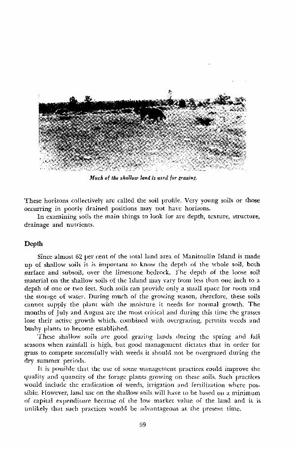
Much of the shallow land is used for grazing.
These horizons collectively are called the soil profile. Very young soils or thoseoccurring in poorly drained positions may not have horizons .
In examining soils the main things to look for are depth, texture, structure,drainage and nutrients.
Depth
Since almost 62 per cent of the total land area of Manitoulin Island is madeup of shallow soils it is important to know the depth of the whole soil, bothsurface and subsoil, over the limestone bedrock. The depth of the loose soilmaterial on the shallow soils of the Island may vary from less than one inch to adepth of one or two feet . Such soils can provide only a small space for roots andthe storage of water. During much of the growing season, therefore, these soilscannot supply the plant with the moisture it needs for normal growth . Themonths of July and August are the most critical and during this time the grasseslose their active growth which, combined with overgrazing, permits weeds andbushy plants to become established .
These shallow soils are good grazing lands during the spring and fallseasons when rainfall is high, but good management dictates that in order forgrass to compete successfully with weeds it should not be overgrazed during thedry summer periods .
It is possible that the use of some management practices could improve thequality and quantity of the forage plants growing on these soils . Such practiceswould include the eradication of weeds, irrigation and fertilization where possible. However, land use on the shallow soils will have to be based on a minimumof capital expenditure because of the low market value of the land and it isunlikely that such practices would be advantageous at the present time .
59

TextureThis term refers to the relative proportion of sand, silt and clay that make
up the soil material . The texture in most soils changes from horizon to horizonand extremes are often present when one kind of deposit overlies another. Inmany of the soil series described the subsoil or B horizon contains more claythan the soil above or below it .
The classes o£ soil texture start with sand which has only a little silt and clay.Then with increasing amounts of clay the principal classes are loamy sand, sandyloam, loam, silt loam, clay loam and clay. The classes can be distinguished bysqueezing a moist sample between the fingers . The sands are harsh and grittyand the particles scarcely hold together . At the other extreme clay can be rolledinto a smooth sticky ball .
In general, soils of intermediate texture such as sandy loams, loams and siltloams are easiest to handle . Sands and loamy sands are open and water drainsreadily through them so they hold rather small quantities of water and are saidto be droughty soils . However, their water holding capacity can be increased tosome extent by adding liberal amounts of barnyard manure or other forms oforganic material . Clays, on the other hand, tend to become hard and stick to-gether in clods unless they are handled carefully .
StructureThe individual soil particles - sand, silt or clay - group themselves to form
various kinds of aggregates which are called structure. The ideal structures arethose which are small and soft such as granular or crumb. The next best are thesmall blocky nut-like aggregates, between which water and roots can move .
The formation of desirable soil aggregates is generally enhanced by organicmatter, that is the dead portions of plant materials which are added to soilseither by the death of plants at the surface or the decay of plant roots. In cultivated soils where crops are continually being removed there is little return madeto the soil of this very important material .
In sandy soils each grain of sand is often by itself. Clayey soils on the otherhand, if deficient in organic matter, becomes cloddy if ploughed when too wetor too dry. Wherever they occur within the depth of normal rooting of plantssuch hard, cloddy soils must be reworked to make them granular or blocky . It isnot enough to break up massive clods . Organic matter must be added as is doneby the addition of barnyard manure or the ploughing clown of green manure inorder that fragments will not flow back together into masses when they are wetagain.
DrainagePoorly drained soils are rarely, if ever, productive . It is possible for grass
crops to survive and frequently flourish under extremely wet conditions but mostcultivated plants cannot remain too long in soils that are saturated with water.
In most cases the drainage condition of the soil can be determined by itsposition in the landscape . Often, however, there is little evidence in the surfacesoil alone of poor drainage beneath. Therefore it is important that such condi-
60

tions be identified by an examination of the soil profile . The conditions of soildrainage are indicated fairly reliably by soil colours . Bright solid colours ofbrown or yellow suggest fairly good drainage, but in low ground, grey and mot-tled horizons indicate poor drainage .
A summary of the drainage conditions of the soils occurring on NfanitoulinIsland is given in the following table.
Nutrients
TABLE 8DRAINAGE OF MANITOULIN ISLAND SOILS
The remedy that must be applied to conditions of poor drainage must bedetermined for each individual field, Where open ditches and high crowns maybe satisfactory for one field, tile drainage may only be suitable for another. In allcases the cost of installation and maintenance of a drainage system in relation tothe price of the crop produced, will need to be considered.
Nutrients are the food that plants derive from the soil . They cannot beseen in the soil but they can be estimated from the vigor of growing plants . Ameasure of nutrients contained in the soil can be obtained accurately in thelaboratory from samples collected by the individual farmer . Soil sample boxesand the procedure for collecting samples can be obtained from the office of thelocal Agricultural Representative at Gore Bay. The samples are tested freeof charge in the laboratory at the Agricultural College, Guelph .
Some general statements can be made with respect to the nutrient elementsthat will apply to all soils occurring in this area .
One of the most important conditions required for good plant growthis that there be a balance of plant nutrients in the soil . All plants take atleast 12 essential elements from the soil . The most common elements foundto be deficient are nitrogen, phosphorus and potassium . "These are the elementscontained in mixed fertilizers . Calcium and magnesium are included in limingmaterials and small amounts are usually present in mixed fertilizers . The otherelements used in lesser amounts are sulphur, iron, boron, manganese, copper,zinc and molybdenum .
Each of the above elements is contained in manure, but since it wouldtake a long time to build up the phosphorus content of a phosphorus deficientsoil with manure alone, it is more practical to use chemical fertilizer inaddition to organic matter . Deficiencies of nitrogen can be remedied bymanure, nitrogenous fertilizers or by the growing of leguminous crops such asred clover and alfalfa particularly if it is ploughed down while a good stand isstill remaining . But only a part of the phosphorus and sulphur supplied tocrops is derived from this organic matter . The remaining portion is derivedfrom the inorganic fraction of the soil .
6 1
DRAINAGE CLASS ACREAGEOF
TOTAL AREAARABLE(ACRES)
NON-ARABLE(ACRES)
Good 558,500 79 .8 98,600 459,900Imperfect 67,300 10 .7 65,000 2,300Poor 40,000 6 .0 20,700 19,300Very Poor 25,800 3 .5 - 25,800
The inorganic or mineral fraction makes up the bulk of most soils. It isderived from rocks of various kinds and their degradation products . Thenutrient supplying power of the larger particles - that is, the sand and silt -are quite different from those of the fine particles or clay fraction . Since thenutrient elements are held in the soil mainly by the finer particles, claytextured soils are commonly considered to have a higher nutrient supplythan coarser textured soils .
In order to estimate the amounts of fertilizer that it is necessary to apply toachieve a balance of plant nutrients in the soil several things need to be deter-mined: the nutrients already in the soil, plus those normally added in manure;the general requirements of the plants to be grown; and the amounts of thenutrients contained in the various fertilizer materials available for use.
This information is being obtained for a great many specific soil typesby the research being done on experimental stations and experimental farmsand by . soil testing laboratories . Differences in climate, soil, and plants meanthat the research must be conducted in many locations . For localities in which noresearch results are available, recommendations are based on results obtained inrelated conditions .
Experiments conducted at the District Experimental Substation at Minde-moya indicate that the use of phosphorus alone or in combination with potashand nitrogen gave the largest increases in yields of the crops tested . Nitrogenand potassium alone produced less consistent results but complete fertilizersat moderate rates produced increased yields . The complete fertilizers in thecase of most soils should contain substantial amounts of phosphorus, mediumlevels of potassium and variable amounts of nitrogen depending on othermanurial treatments. Manure gives increased yields on all soils . It not onlysupplies nitrogen and to a lesser degree phosphorus and potassium but alsoimproves the physical condition and increases the moisture holding capacity ofthe soil . In general the nitrogen needed for the grain crops can be suppliedby growing legumes. In this way the nitrogen is supplied and the soil is keptin good physical condition . For specific recommendations with regard tofertilizer analyses and rates to be used on crops grown on the Island the readeris referred to the recommendations given by the Advisory Fertilizer Board forOntario.
Lime is deficient in some of the soils on Manitoulin Island . Lime isrequired on the Wendigo, Mallard, Thwaites, Casey, Bucke, and Otterskinsoils . Soil tests should be used to determine the need for lime on the other soilsof the surveyed area . The limestone rock in the area could be used as a sourceof lime if crushed and finely pulverized . For quick effects, it is desirable to usea product the most of which will pass through a 100-mesh screen.
Sources of Information
Agricultural colleges and the Experimental Farm system can give muchinformation that is useful in solving soil management problems for any particular
62
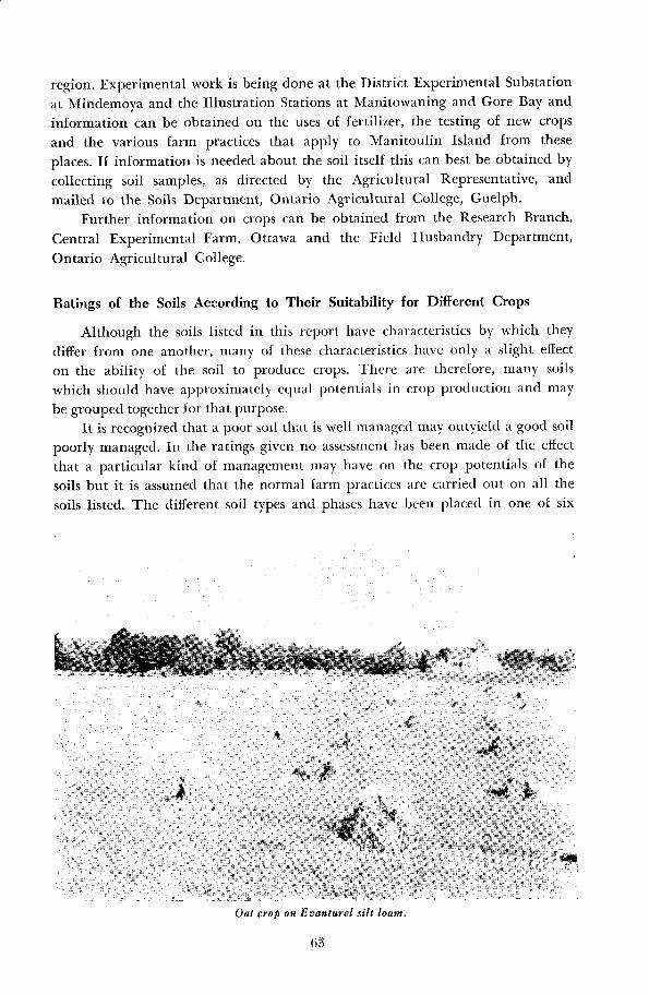
region . Experimental work is being done at the District Experimental Substationat Mindemoya and the Illustration Stations at Manitowaning and Gore Bay andinformation can be obtained on the uses of fertilizer, the testing of new cropsand the various farm practices that apply to Manitoulin Island from theseplaces . If information is needed about the soil itself this can best be obtained bycollecting soil samples, as directed by the Agricultural Representative, andmailed to the Soils Department, Ontario Agricultural College, Guelph .
Further information on crops can be obtained from the Research Branch,Central Experimental Farm, Ottawa and the Field Husbandry Department,Ontario Agricultural College.
Ratings of the Soils According to Their Suitability for Different Crops
Although the soils listed in this report have characteristics by which theydiffer from one another, many of these characteristics have only a slight effecton the ability of the soil to produce crops. There are therefore, many soilswhich should have approximately equal potentials in crop production and maybe grouped together for that purpose.
It is recognized that a poor soil that is well managed may outyield a good soilpoorly managed. In the ratings given no assessment has been made of the effectthat a particular kind of management may have on the crop potentials of thesoils but it is assumed that the normal farm practices are carried out on all thesoils listed . The different soil types and phases have been placed in one of six
Oat crop on Evanturel silt loam .
63
groups namely, good cropland, good to fair cropland, fair cropland, fair to poorcropland, poor cropland and unsuitable for crops .
This rating represents an estimate of the crop producing ability of the soilbased on the characteristics of the soil itself and the crops observed on the soil,together with information supplied by farmers and experimental workers . Although the reliability of these groupings have not been verified by crop yieldfigures they have in other counties proven to be reasonably accurate for purposesof farm management and land use planning .
The meanings of the letters used in the tables are as follows : G-Good, G-FGood to Fair, F-Fair, F-P Fair to Poor, P-Poor.
TABLE 9CROP ADAPTABILITY RATINGS FOR GOOD CROPLAND
MIXED RED
The soil types included in this group give higher yields and are adaptableto a greater variety of crops than any other soils occurring in the district . Theypossess the ideal texture for this region ; they are stone free and have sufficientdepth for root development and storage of moisture . The Earlton and Gordonsoils can be improved by draining and in this respect are inferior to the Campbelland Evanturel soils . The latter are subject to surface erosion by water, a problemthat is serious only where the soil is left bare during heavy rainy seasons .
TABLE 10CROP ADAPTABILITY RATINGS FOR GOOD TO FAIR CROPLAND
MIXED RED
The soils in this group possess certain limitations in crop production thatmake them less suitable and less productive than the previous group . The Burfordsoils have only a moderate water holding capacity and are frequently stony .The Thwaites soil is susceptible to water erosion . The Buzwah soils are stonyand the stones are so numerous that they must be removed before cultivation .In general these soils produce only moderate yields of oats and mixed grainsbut are probably as good as the first group of soils in the production of hay .Satisfactory yields of grain or hay require frequent use . of commercial fertilizers .Some application of lime may also be necessary on the Thwaites soils.
64
SOIL TYPE OATS GRAINS ALFALFA CLOVER ALSIKE TIMOTHY POTATOES PASTURE
Earlton silt loam G G F G G G F GGordon silty clay loam G-F G-F F G G G F GEvanturel silt loam G-F G-F G-F G G G F-P GCampbell silty clay loam G-F F F G-F G-F G F-P G
SOIL TYPE OATS GRAINS ALFALFA CLOVER ALSIKE TIMOTHY POTATOES PASTURE
Buzwah clay loam F F G-F G-F G-F G-F P G-FBuzwah silty clay loam F F G-F G-F G-F G-F P G-FBurford loam G-F G-F F F F F F G-FThwaites silt loam G-F G-F F-P F-P F G-F G-F G-F

TABLE 11CROP ADAPTABILITY RATINGS FOR FAIR CROPLAND
MIXED RED
This group includes those soils which have severe limitations in crop pro-
duction, as a result of poor texture or shallowness over bedrock. Both of these
conditions control the moisture supply in the soil so that cereal and hay crops
are affected in spite of good management practices. Stones interfere with cultiva-
tion on the Vasey and Dumfries soils and require constant removal as they occur
in the soil mass as well as at the surface.These soils can be used for growing both grain and hay but such crops will
require the use of commercial fertilizers . Since the yields of grain can be expected
to be lower on these soils than on the soils of the better groups, cost of pro-
duction may eliminate their use for that purpose.
TABLE 12CROP ADAPTABILITY RATINGS FOR FAIR TO POOR CROPLAND
MIXED RED
types included in this group possess characteristics that limit theira few crops or to agricultural uses that do not require cultivation .
The problems associated with these soils are drainage, shallowness, low fertility,
susceptibility to erosion and stoniness. Any one or a combination of several ofthese problems may be associated with a particular soil in this group. A soil may
be improved without entirely correcting or overcoming the problem. Such im-
The soilsuitability to
65
SOIL TYPE OATS GRAINS ALFALFA CLOVER ALSIKE TIMOTHY POTATOES PASTURE
Casey silt loam F F F-P F-P F F G FEarlton silt loam-shallow
phase F F F-P F-P F F F G-FCampbell silty clay
loam-shallow phase F F F-P F F F F-P FEvanturel silt
loam-shallow phase F F F-P F F F F-P FGordon silty clay
loam-shallow phase F F F-P F-P F F F-P FBurford sandy loam F-P F-P F F F F F-P F
Cane silt loam F F P F-P F F F-P FVasey loam F F F-P F F F P F-PWolsey silty clay loam F-P F-P P F F F P FDumfries loam F-P F-P P F F F P F-P
SOIL TYPE OATS GRAINS ALFALFA CLOVER ALSIKE TIMOTHY POTATOES PASTURE
Leech clay loam F-P F-P F-P F F F P F-PLeech silty clay loam F-P F-P F-P F F F P F-PBuzwah clay loam-shallow
phase F-P F-P F-P F-P F F P FDonnybrook sandy loam P P F F F F P FBucke fine sandy loam F-P F-P P P F-P F G-F F-PWendigo fine sandy loam F-P F-P P P P F G-F F-PLeech silty clay
loam-shallow phase F-P F-P F-P F-P F F P FLeech clay loam-shallow
phase F-P F-P F-P F-P F F P FPike clay F-P P F-P F-P F-P F P FOtterskin fine sandy loam F-P F-P P P P F-P F F-PBurford loam-shallow
phase P P F-P F-P F-P F-P P FBrisbane loam F-P P P F-P F-P F-P P F-PHowland loam F-P F-P P P F-P F-P P F-P

provement, although only partial improvement for potential hay and pastureland, may be economical . The soil types that have some potential uses for cerealsare the Leech soils .
TABLE 13CROP ADAPTABILITY RATINGS FOR POOR CROPLAND
MIXED RED
This group includes a large number of minor soil types which are used chieflyfor grazing or for forestry . However, many of the soil types here could be usedfor growing a wider range of crops if improved . Soils such as Wendigo sandyloam, Bucke sandy loam, Otterskin sandy loam and Mallard sandy loam arebeing used successfully for specialized crops elsewhere in the province.
Wolsey silty clay loam-stony phaseCampbell silty clay loam-shallow, stony phaseGordon silty clay loam-shallow, stony phaseKagawong silt loamPhipps clay loam-shallow phaseBass clay-stony phasePerch clayLeech silty clay loam-stony phaseCane silt loam-stony phaseWolsey silty clay loam-shallow, stony phasePhipps silty clay loam-stony phasePerch clay-stony phase
TABLE 14NON-ARABLE LAND
66
Buzwah silty clay loam-stony phaseFarmington loamLittle Current clayDonnybrook sandy loamEvanturel silt loam-stony phaseEarlton silt loam-stony phaseCampbellsilty clayloam-stonyphaseGordon silty clay loam-stony phasePike clay-stony phaseMuck
The soils included in this group comprise about 72 per cent of the landarea of Manitoulin Island . With the exception of the Farmington soils mostof them occur as small isolated areas and can serve as woodlots or grazing land .The Farmington soils make up 60 per cent of the land area and although theyare unsuitable for the growing of cultivated crops they are the grazing land soilsof Manitoulin Island .
SOIL TYPE OATS GRAINS ALFALFA CLOVER ALSIKE TIMOTHY POTATOES PASTURE
Howland sandy loam F-P P P P F-P F-P P F-PBucke sandy loam F-P F-P P P P P F-P F-PBass clay F-P F-P P P P F-P P F-PVasey loam-shallow phase P P P F-P F-P F-P P F-PWolsey silty clay
loam-shallow phase F-P F-P P P P F-P P F-POtterskin sandy loam F-P F-P P P P P F-P PCane silt loam-shallow
phase P P P P P F-P P FHowland loam-shallow
phase P P P P F-P F-P P F-PEnglehart fine sandy loam P P P P P F-P P F-PWendigo sandy loam P P P P P P F-P PWendigo sand P P P P P P F-P PPhipps clay loam P P P P P P P F-PPhipps silty clay loam P P P P P P P F-PEnglehart sandy loam P P P P P P P PMallard sandy loam P P P P P P P P

Gilford loamGilford sandy loamKillean loamLily loamLyons loamKenabeek sandy loamMallard sandy loam-shallow phaseMallard sandy loam-stony phase
TABLE 15UNSUITED FOR AGRICULTURE
Lyons loam-shallow phaseBridgman sandBurpee muckMarshRock-WendigoRock
The soils included in this group are unsuited to agriculture since they can-
not be cultivated nor can they be used for grazing. In some places the soils arecovered with stones and trees and grass is sparse ; in others, there is no cover ofany kind and the bare rock or soil materials are exposed. The soils should bereforested .
APPENDIX
TAXONOMIC CLASSIFICATION, PROFILE DESCRIPTIONS
AND ANALYTICAL DATA
In the following pages profile descriptions of each soil series are presentedtogether with analytical data for selected soils . The analyses of surface samplesare included to indicate comparative levels of plant nutrients in the surface soilsof the island .
The methods of analysis were as follows:
59 :7-9, 1945.
DUMFRIES SERIES
LOCALITY : Lot 3, Con. VI, Howland Twp.PARENT MATERIAL : Stony calcareous, sandy loam till*CLASSIFICATION : Great Soil Group - Grey-Brown Podzolic
Soil Group - Orthic Grey-Brown PodzolicFamily - Dumfries
DESCRIPTION :
A, -Thin layer of partially decomposed leaves, twigs, etc.A, - 0-3 inches loam ; dark brown (10 YR 4/3) ; fine granular
structure; friable consistency; frequent stones ; pH - 6.5 .A,,-3-6 inches loam ; yellowish brown (10 YR 5/4); weak platy;
friable; few stones ; pH - 6 .3 .A,2-6-10 inches loam ; pale brown (10 YR 6/3) ; weak platy ;
friable; occasional stones ; pH - 6.0.B, - 10-13 inches loam ; dark yellowish brown (10 YR 4/4) ;
fine nuciform ; friable; moderately stony; pH - 6.5 .BZ - 13-20 inches clay loam ; dark brown (10 YR 4/3) ; medium
nuciform ; friable; very stony; pH - 7.0 .C -Stony sandy loam till ; light grey (10 YR 7/2) ; single grain;
loose; calcareous; pH - 7 .8 .
'The classification of each series, into Soil Group and Family is made on the basis of thedefinitions given by the National Soil Survey Committee 1958 .
68
Mechanical Analysis - Bouyoucos Hydrometer Method,Soil Science, Vol. 42, 1936,p. 225.
Reaction - Atkinson H. .J . et al ., Contribution169, Canada Department ofAgriculture 1955 .
Base Exchange Capacity and - Schollenberger Method, SoilExchangeable Bases Science, 51 :1, 1945 .Organic Matter - Walkley Method, Soil Science
63 :251-264, 1947.Calcium and Magnesium - Cheng Methods, Soil Science
72 :449-558, 1951 and SoilScience 75 :37-40, 1953 .
Fusion Analysis - Robinson Method, Soil Science

KILLEAN SERIESLOCALITY : Lot 5, Con. IV, Howland Twp.PARENT MATERIAL : Stony, calcareous, sandy loam tillCLASSIFICATION : Great Soil Group - Grey-Brown Podzolic
Soil Group - Gleyed Grey-Brown PodzolicFamily - Killean
DESCRIPTION :
A o -Thin layer of partially decomposed leaves, twigs, etc.A 1 - 0-5 inches loam ; very dark greyish brown (10 YR 3/2) ; fine
granular structure; friable consistency; pH - 6.8 .A, - 5-12 inches loam ; yellowish brown (10 YR 5/4) ; slightly
mottled; weak platy; friable ; very stony; pH - 6.4 .B_ - 12-20 inches loam; dark brown
(10 YR 4/3) ; mottled;medium nuciform ; friable; very stony; pH - 7 .0 .
C - Stony sandy loam till ; light grey (10 YR 7/2) ; single grain;loose; many stones and boulders ; calcareous ; pH - 7.4 .
LILY SERIESLOCALITY : Lot 3, Con. IV, Howland Twp.PARENT MATERIAL : Stony, calcareous, sandy loam tillCLASSIFICATION : Great SOIL Group - Dark Grey Gleisolic
Soil Group - Orthic Dark Grey GleisolicFamily - Lyons
DESCRIPTION :
A o -Thin layer of partially decomposed leaves, twigs, etc.A 1 -0-7 inches loam; black (10 YR 2/1) ; fine granular struc-
ture ; friable consistency; very stony; pH - 7.2 .G - 7-20 inches loam ; greyish brown (10 YR 5/2) ; very mottled;
weak medium nuciform ; friable; very stony; pH - 7.3 .C - Coarse sandy loam till ; light grey (10 YR 7/2) ; many stones
and boulders ; calcareous ; pH - 7.6 .
VASEY SERIESLOCALITY:
Lot 21, Con. IX, Robinson Twp.PARENT MATERIAL: Calcareous, loam or sandy loam tillCLASSIFICATION : Great Soil Group - Grey-Brown Podzolic
Soil Group - Bisequa Grey-Brown PodzolicFamily - Vasey
DESCRIPTION : A,, - Thin layer of partially decomposed leaves, twigs, etc.A, - 0-9_ inches loam ; very dark greyish brown (10 YR 3/2) ;
medium granular structure; friable consistency ; very stony;pH - 5.6 .
B,,p - 2-12 inches loam ; dark brown (7.5 YR 4/4) ; weak mediumnuciform ; friable; moderately stony; pH - 5.8 .
B__p - 12-19 inches loam; yellowish brown
(10 YR 5/6) ; weakfine nuciform ; friable; moderately stony; pH - 6.0 .
69

TABLE 16CHEMICAL AND PHYSICAL ANALYSES OF VASEY LOAM
MECHANICAL ANALYSES EXCHANGEABLE BASES
HORIZON 0~SILT PH
%O.M .
EXCHANGECAPACITYM.E./100 Ca Mg K S102 R203 FC2O3 A120 3 Ca0 MgO K20
%%0 M.E ./ M.E./ M.E ./
% % % % % % %SAND .05- CLAY gm . 100 100 1001- .05 .002 <.002 gm . gm, gm.mm mm mm
AI 49 .7 38 .2 12 .1 5 .6 3 .3 14 .7 10 .7 2 .5 0 .1 71 .6 18 .7 4 .8 15 .2 2 .4 1 .2 2 .8
B21 47 .2 40 .0 12 .8 5 .8 0 .4 5 .6 3 .6 0 .8 0 .08 70 .8 18 .9 5 .4 15 .3 2 .3 0 .9 2 .7
B22 48 .4 40 .4 11 .2 6 .0 0 .1 5 .1 3 .1 0 .7 0.06 70 .6 20 .2 5 .1 15 .7 2 .4 0 .8 2 .6
A2G.B .P . 52 .1 36.9 11 .0 6 .1 0 .0 4.0 2 .8 0 .4 0 .04 78 .3 14 .3 2 .3 11 .9 1 .9 0.6 2 .6
B2G.B.P. 49 .2 35 .2 15 .6 6 .7 0 .0 7 .3 6 .0 0 .9 0 .1 70 .2 20 .4 5 .9 15 .4 2 .7 1 .1 2 .7
C 57 .9 30 .5 11 .6 7 .8 0 .0 3 .9 16 .5 2 .1 0 .08 66 .6 18 .6 5 .0 12 .6 7 .6 2 .3 2 .5
Azsbp19-30 inches loam ; very pale brown (10 YR 7/4) ; weakfine platy; friable; moderately stony; pH - 6.1 .
BZSbp30-34 inches loam ; yellowish brown (10 YR 5/4); weakmedium nuciform ; friable; moderately stony; pH - 6.7 .
C - Loam till ; pale brown (10 YR 6/3) ; friable; very stony;calcareous ; pH - 7.8 .
HOWLAND SERIES
LOCALITY : Lot 51, Con. 11, Assiginack Twp.PARENT MATERIAL : Calcareous, loam or sandy loam tillCLASSIFICATION : Great Soil Group - Grey-Brown Podzolic
Soil Group - Gleyed Grey-Brown PodzolicFamily - London
DESCRIPTION :
A� - Thin layer of partially decomposed leaves, twigs, etc.A, - 0-3 inches loam ; very dark greyish brown (10 YR 3/2) ;
medium granular structure; friable consistency; very stony;pH - 6.0 .
A,,-3-14 inches loam ; brown (10 YR 5/3) ; slightly mottled ;weak medium nuciform ; friable; moderately stony; pH -6.3 .
A=:-14-23 inches loam ; light yellowish brown (10 YR 6/4) ;mottled; weak fine nuciform ; friable; moderately stony;pH - 6 .4 .
B, - 23-26 inches loam ; yellowish brown (10 YR 5/6); mottled;weak fine nuciform ; friable; moderately stony; pH - 7.0 .
C -Loam till ; pale brown (10 YR 6/3) ; friable; very stony;calcareous ; pH - 7 .8 .
LYONS SERIES
LOCALITY : Lot 29, Con. Xl, Dawson Twp .PARENT MATERIAL :
Calcareous, loam or sandy loam tillCLASSIFICATION : Great Soil Group - Dark Grey Gleisolic
Soil Group - Orthic Dark Grey GleisolicFamily - Lyons
DESCRIPTION : A.-Thin layer of partially decomposed leaves, twigs, etc.A, - 0-6 inches loam ; black
(10 YR 2/1) ; medium granularstructure; friable consistency ; very stony; pH - 7 .4 .
G - 6-20 inches loam ; dark grey
(10 YR 4/1) ; very mottled;weak medium nuciform ; friable; very stony; pH - 7.0 .
C -Loam till ; light yellowish brown (10 YR 6/4) ; very mottled;very stony; calcareous ; friable; pH - 7.8 .
BUZWAH SERIES
LOCALITY : Lot 15, Con. 11, Tehkummah Twp.PARENT MATERIAL : Layers of reddish clay loam till and greyish loam till ;
often mixed to form variegated colored till . Tills derivedfrom Medina and Trenton bedrock.
7 1

CLASSIFICATION : Great Soil Group - Grey WoodedSoil Group - Orthic Grey WoodedFamily - Haileybury
.DESCRIPTION : A0--Thin layer of partially decomposed leaves, .twigs, etc.
Al - 0-2 inches clay loam; very dark greyish brown (10 YR 3/2) ;medium granular structure; friable consistency; very stony;pH - 6.2.
A21-2-5 inches clay loam ; yellowish brown (10 YR 5/6) ; mediumgranular ; friable; very stony; pH - 6.0 .
A2,-5-15 inches loam ; very pale brown (10 YR 7/4) ; weak fineplaty; friable; moderately stony; pH - 5 .7 .
AB-15-20 inches clay loam ; yellowish brown (10 YR 5/4) ;medium nuciform ; firm ; aggregates coated with very palebrown material; stony; pH - 6.4 .
B: - 20-26 inches clay loam ; dark brown (7.5 YR 4/4) ; mediumnuciform; firm ; very stony; pH - 6.8 .
C - Clay loam till ; pinkish grey (7 .5 YR 6/2) ; and pale brown(10 YR 6/3) ; hard; calcareous ; moderately to very stony;pH - 7.8 .
TABLE 17CHEMICAL AND PHYSICAL ANALYSES OF THE CULTIVATED SURFACE OF
SOME BUZWAH SOILS
LEECH SERIESLOCALITY : Lot 45, Con. 11, Assiginack Twp.PARENT MATERIAL : A variegated layering of calcareous clay loam and loam
tills.CLASSIFICATION : Great Soil Group - Grey Wooded
Soil Group - Gleyed Grey WoodedFamily - Renfrew
DESCRIPTION : A.-Thin layer of partially decomposed leaves, twigs, etc.A1 - 0-2 inches clay loam ; very dark greyish brown (10 YR 3/2) ;
fine nuciform structure; friable consistency; moderatelystony; pH - 6 .4 .
72
Location MechanicalAnalyses
Ex-
ExchangeableBases
change p/O/C Silt % m e/1100 Ca Mg K pH O.M .
Townshiphip Conc. Lot Sand -'05 Clay gm . m.e ./.e ./ m .e ./ m.e ./1-,05 .002 <.002 100 100 100mm mm mm gm . gm. gm .
CultivatedSurface Sandfield VI 22 31 .0 41 .2 27 .8 20 .18 13 .57 1 .66 0 .15 5.9 6 .0
" Sandfield IV 15 33 .4 42.4 24 .2 23 .75 16 .95 2.81 0 .17 6.2 8 .2" Tehkummah III 20 34 .8 34 .0 31 .2 24 .17 18 .94 2 .04 0 .13 6.4 5 .5" Sandfield XI 16 34 .5 36 .0 29 .5 28 .66 21 .32 4 .47 0 .24 6.5 8 .7" Assiginack II 27 37 .2 23 .1 39 .7 25 .76 24 .36 3 .73 0 .45 6.8 7 .5

A, - 2-9 inches clay loam ; very pale brown (10 YR 7/3) ; mottled;weak fine platy ; friable; moderately stony; pH - 6.0 .
AB-9-12 inches clay loam ; pale brown (10 YR 6/3) ; mottled;medium nuciform ; firm ; aggregates coated with very palebrown material; stony; pH - 6.4 .
B_ - 9-18 inches clay loam ; brown (7.5 YR 5/2) ; mottled; fineblocky; plastic when wet, hard when dry; moderately stony;pH - 6.8 .
C - Clay loam till ; pinkish grey (7.5 YR 6/2) ; and grey (10 YR6/1) ; hard; calcareous ; moderately stony; pH - 7.8 .
PHIPPS SERIES
LOCALITY: Lot 10, Con VII, Barrie IslandPARENT MATERIAL : A variegated layering of calcareous clay loam and loam
tillCLASSIFICATION : Great Soil Group - Dark Grey Gleisolic
Soil Group - Orthic Dark Grey GleisolicFamily - Brookston
DESCRIPTION : A.-Thin layer of partially decomposed leaves, twigs, etc.A, - 0-5 inches clay loam ; black
(10 YR 2/l); fine nuciformstructure; friable consistency ; moderately stony; pH - 6.6 .
G -5-19 inches clay loam ; grey (l0 YR 5/1) ; very mottled;mottles strong brown (7 .5 YR 5/6 ) in colour; coarse blocky ;hard when dry, plastic when wet; moderately stony; pH -7.0 .
C - Clay loam till ; pinkish grey (7 .5 YR 6/2) and grey (10 YR6/1) ; very mottled; hard when dry, plastic when wet; cal-careous; moderately stony; pH - 8.0 .
DONNYBROOK SERIES
LOCALITY : Lot 6, Con. VII, Howland Twp.PARENT MATERIAL : Stony, gravelly, calcareous outwashCLASSIFICATION : Great Soil Group - Grey-Brown Podzolic
Soil Group - Orthic Grey-Brown PodzolicFamily - Dumfries
DESCRIPTION :
Ao - Thin layer of partially decomposed leaves, twigs, etc.A, - 0-4 inches gravelly sandy loam ; dark grey-brown (10 YR
4/2) ; fine crumb structure; very friable consistency; moder-ately to very stony; pH - 7.2 .
A,,-4-6 inches gravelly sandy loam ; yellowish brown (10 YR5/6) ; weak fine platy; very friable; pH - 6.9 .
A__-6-10 inches gravelly sandy loam ; pale brown (10 YR 6/3) ;single grain; loose; pH - 6.7 .
B2 - 10-16 inches gravelly sandy loam ; dark brown (10 YR 4/3);weak fine nuciform; friable ; very stony; pH - 7 .2 .
C - Sand and gravel ; very pale brown (10 YR 7/3) ; single grain ;loose; calcareous ; very stony; pH - 8.0.
73

TABLE 18CHEMICAL AND PHYSICAL ANALYSES OF WENDIGO SANDY LOAM
MECHANICAL ANALYSES EXCHANGEABLE BASES
%
EXCHANGECAPACITY $102 R203 Fe203 A1203 CaO MgO K20
HORIZON % SILT % PH O.M . M.E./100 Ca Mg K % % % % % 0/0M.E ./ M.E ./ M.E ./SAND .05- CLAY grn. 100 100 1001- .05 .002 <.002mm mm mm gm. gm. gm .
!12 70 .3 27 .0 2 .7 4.8 0.62 2 .18 0 .39 0 "17 0.04 82 .7 11 .6 0,8 10.4 1 .4 0 .1 2 .1
B2 81 .3 16 .4 2 .3 5.6 0.93 4.53 0 .28 0.14 0 .07 74 .2 16 .4 3 .0 13 .2 2.1 0.6 1 .8
B3 86 .8 13 .6 1 .6 5.9 0.35 2 .62 0 .45 0 .18 0 .04 75 .6 15 .9 2 .8 12 .9 2.1 0 .7 1 .8
C 95 .6 4 .2 0.2 6.2 0.00 0,91 0 .11 0 .05 0 .02 75.6 15.5 2 .8 12 .6 2 .3 1 .0 1 .9

WENDIGO SERIES
LOCALITY: Lot 8, Con. V1, Billings Twp.PARENT MATERIAL : Non-calcareous outwash sandCLASSIFICATION : Great Soil Group - Podzol
Soil Group - Orthic PodzolFamily - Wendigo
DESCRIPTION :
A o - 1-0 inches raw humus and roots; very dark grey (10 YR3/1) ; pH - 5.2 .
A 2 - 0-3 inches sand ; white (10 YR 8/2) ; single grain structure ;loose consistency; pH - 5.0 .
B21-3-12 inches sand ; yellowish brown
(10 YR 5/8) ; singlegrain; loose; pH - 5.5 .
B22-12-26 inches sand ; light yellowish brown
(10 YR 6/4) ;single grain; loose; pH - 5.8.
C -Sand; very pale brown
(10 YR 7/2) ; single grain; loose;non-calcareous ; pH - 6.0 .
MALLARD SERIES
LOCALITY: Lot 12, Con. VIII, Billings Twp.PARENT MATERIAL : Non-calcareous outwash sandCLASSIFICATION : Great Soil Group - Podzol
Soil Group - Gleyed PodzolFamily - Rubicon
DESCRIPTION :
Ao - 1-0 inches raw humus and roots, very dark grey
(10 YR3/1) ; pH - 5.0 .
A 2 - 0-4 inches sandy loam ; white
(10 YR 8/2) ; single grainstructure; loose consistency; pH - 4.5 .
B2 - 4-20 inches sandy loam ; brown
(10 YR 5/3) ;
mottled;single grain ; occasionally cemented ; pH - 5.6 .
C - Sandy loam; pale brown (10 YR 7/3) ; mottled; single grain;pH-6.1 .
KENABEEK SERIESLOCALITY: Lot 11, Con. VII, Billings Twp.PARENT MATERIAL : Non-calcareous outwash sandCLASSIFICATION : Great Soil Group - Dark Grey Gleisolic
Soil Group - Orthic Dark Grey GleisolicFamily - Kenabeek
DESCRIPTION :
A,-0-5 inches sandy loam ; very dark brown (10 YR 2/2) ;highly organic; fine crumb structure ; friable consistency;pH - 5.2 .
G - 5-18 inches sandy loam ; grey (10 YR 6/1) ; very mottled;single grain; loose ; pH - 6 .0 .
C -Sandy loam; very pale brown (10 YR 7/3) ; very mottled;single grain; loose; pH - 6.6 .
75

BURPEE SERIESLOCALITY : Lot 21, Con. X111, Campbell Twp.PARENT MATERIAL : Non-calcareous outwash sandCLASSIFICATION : Great Soil Group - Gleysol
Soil Group - Peaty GleysolFamily - Burpee
DESCRIPTION :
Ao - 6-0 inches ; well decomposed organic material ; black
(10YR 2/1) ; pH - 6.5 .
G, - 0-12 inches sand ; greyish brown
(10 YR 5/2) ;
slightlymottled; single grain structure; loose consistency; pH - 6 .7 .
G~ - 12-24 inches sand ; brown
(10 YR 5/3) ; slightly mottled;single grain; loose ; pH - 6.8 .
C - Sand ; dark greyish brown
(10 YR 4/2) ; slightly mottled;single grain; loose ; pH - 6.9 .
BURFORD SERIESLOCALITY: Lot 3, Con. 1, Billings Twp.PARENT MATERIAL : Loam and sandy loam deposits underlain by gravelCLASSIFICATION : Great Soil Group - Grey-Brown Podzolic
Soil Group - Orthic Grey-Brown PodzolicFamily - Burford
DESCRIPTION : A,,-Thin layer of partially decomposed leaves, twigs, etc.A, - 0-3 inches loam; very dark greyish brown
(10 YR 3/2) ;fine granular structure; friable consistency; few stones ;pH - 6.0 .
A,,-4-17 inches loam ; yellowish brown (10 YR 5/4) ; weak fineplaty; very friable ; few stones ; pH - 5.4 .
Ar,-17-20 inches gravelly loam; light yellowish brown . (10 YR6/4) ; weak fine platy; very friable; pH - 6.2 .
B.-20-33 inches gravelly loam ; dark brown (10 YR 4/3) ;medium nuciform structure; hard consistency; gravelly ;moderately stony; pH - 6.8 .
D -Gravel and sand; pale brown (10 YR 6/3) ; single grainstructure; loose consistency; calcareous ; pH - 7.8 .
BRISBANE SERIESLOCALITY: Lot 27, Con. V1, Howland Twp.PARENT MATERIAL : Loam and sandy loam deposits underlain by gravelCLASSIFICATION : Great Soil Group - Grey-Brown Podzolic
Soil Group - Gleyed Grey-Brown PodzolicFamily - Brady
DESCRIPTION : A,,-Thin layer of partially decomposed leaves, twigs, etc.A,-0-6 inches loam; very dark greyish brown (10 YR 3/2) ;
fine granular structure; friable consistency; moderatelystony; pH - 6.6 .
Az -6-10 inches loam; yellowish brown
(10 YR 5/4) ; slightlymottled ; weak fine platy; friable; very stony ; pH - 6.0 .
76

B~ - 10-22 inches gravelly loam ; dark brown
(10 YR 4/3) ;mottled; medium nuciform; firm ; moderately stony; pH -7.0 .
D -Gravel and sand ; pale brown (10 YR 6/3), single grain;loose, calcareous ; pH - 7.8 .
GILFORD SERIES
LOCALITY: Lot 30, Con. V, Howland Twp.PARENT MATERIAL : Loam and sandy loam deposits underlain by gravelCLASSIFICATION :
Great Soil Group - Dark Grey GleisolicSoil Group - Orthie Dark Grey GleisolicFamily - Granby
DESCRIPTION :
A, _Thin layer of partially decomposed leaves, twigs, etc.Al - 0-6 inches loam ; very dark brown (10 YR 2/2) ; fine granu-
lar structure; friable consistency ; very stony ; pH - 7.0 .G -6-16 inches loam ; greyish brown (10 YR 5/2) ; mottled;
medium blocky ; friable; moderately stony; pH - 7 .2 .D - Gravelly outwash; pale brown (10 YR 6/3) ; single grain;
loose; calcareous ; pH - 7 .8 .
BUCKS SERIES
LOCALITY: Lot 38, Con. VII, Burpee Twp.PARENT MATERIAL :
Non-calcareous outwash sand underlain by calcareous siltyclay at depths of less than 3 feet
CLASSIFICATION : Great Soil Group - PodzolSoil Group - Orthic PodzolFamily - Bucke
DESCRIPTION :
Ao - 1-0 inches raw humus and roots; very dark grey ;
(10 YR3/1) ; pH - 5.2 .
AZ - 0-2 inches fine sandy loam ; light grey (10 YR 7/2) ; singlegrain structure; loose consistency; stonefree; pH - 6.3 .
B,,-2-9 inches fine sandy loam ; (10 YR 5/8) ; single grain; loose;stonefree; pH - 6.3 .
B,,-9-18 inches fine sandy loam ; brownish yellow (10 YR 6/6) ;mottled; weak fine nuciform ; loose ; stonefree; pH - 6.4 .
D - Silty clay ; light brownish grey (10 YR 6/2) ; varved ; veryplastic when wet, very hard when dry ; stonefree; calcareous ;pH - 7.8 .
OTTERSKIN SERIES
LOCALITY: Lot 7, Con. VII, Carnarvon Twp.PARENT MATERIAL :
Non-calcareous outwash sand underlain by calcareous siltyclay at depths of less than 3 feet .
CLASSIFICATION : Great Soil Group - PodzolSoil Group - Gleyed PodzolFamily - Locksley
77
DESCRIPTION :
Ao - 2-0 inches raw humus and roots; very dark grey (10 YR3/1) ; pH-5.0.
Az - 0-2 inches sandy loam; light grey (10 YR 7/1); single grainstructure; loose consistency ; stonefree; pH - 4.8 .
B2,-2-18 inches sandy loam ; yellowish brown (10 YR 5/6);mottled; single grain; loose; stonefree; pH - 5.4 .
Bz2-18-25 inches sandy loam ; brownish yellow (10 YR 6/6) ;mottled; single grain; loose; stonefree; pH - 5:8 .
D -Silty clay ; light brownish grey (10 YR 6/2); varved ; veryplastic when wet, very hard when dry; stonefree; calcareous ;pH - 7.8 .
ENGLEHART SERIESLOCALITY : Lot 18, Con. IV, Gordon Twp.PARENT MATERIAL :
Non-calcareous outwash sand underlain by calcareous siltyclay at depths of less than 3 feet
CLASSIFICATION : Great Soil Group - Dark Grey GleisolicSoil Group - Orthic Dark Grey GleisolicFamily - Kenabeek
DESCRIPTION :
Ao -Thin layer o£ partially decomposed leaves, twigs, etc.A, - 0-5 inches fine sandy loam ; very dark brown (10 YR 2/2);
fine crumb structure; very friable consistency; stonefree;pH - 5.2 .
G - 5-16 inches fine sandy loam ; grey (10 YR 6/1) ; very mot-tled ; single grain; loose; stonefree; pH - 5.4 .
D -Silty clay ; light brownish grey (10 YR 6/2) ; varved ; veryplastic when wet, very hard when dry; stonefree; pH - 7.8 .
THWAITES SERIESLOCALITY: Lot 28, Con. IX, Billings Twp.PARENT MATERIAL:
Non-calcareous silt loam underlain by silty clay at depthsof less than 3 feet
CLASSIFICATION : Great Soil Group - Grey WoodedSoil Group - Bisequa Grey WoodedFamily - Evanturel
DESCRIPTION :
Ao - 1-0 inches raw humus and roots; very dark grey ; (10 YR3/1) ; pI-I - 5 .2 .
A2P - 0-2 inches silt loam ; white (10 YR 8/2) ; fine platy struc-ture ; soft consistency ; stonefree; pH - 5.2 .
B2P - 2-10 inches silt loam ; yellowish brown (10 YR 5/6); weakplaty; soft ; stonefree; pH - 5.3 .
A:gw- 10-18 inches silt loam ; very pale brown (10 YR 7/3) ; weakplaty; soft ; stonefree; pH - 5 .3 .
B,gw- 18-26 inches silty clay loam ; yellowish brown
(10 YR5/4) ; medium nuciform ; friable; stonefree; pH - 5.6 .
D - Silty clay ; light brownish grey ;
(10 YR 6/2) ; massivestructure; very plastic when wet, very hard when dry;stonefree; calcareous ; pH - 7 .8 .
78
CASEY SERIESLOCALITY: Lot 26, Con. VII, Billings Twp.PARENT MATERIAL :
Non-calcareous silt loam underlain by calcareous silty clayat depths of less than 3 feet.
CLASSIFICATION :
Great Soil Group - Grey WoodedSoil Group - Gleyed Grey WoodedFamily - Earlton
DESCRIPTION :
A o - 1-0 inches raw humus and roots ; very dark grey ; (10 YR3/1) ; pH - 5.3 .
A, - 0-2 inches silt loam ; white (10 YR 8/2) ; fine platy struc-ture ; soft consistency; stonefree ; pH - 5.0 .
B,P - 2-8 inches silt loam ; yellowish brown (10 YR 5/8) ; slightlymottled; weak platy ; soft ; stonefree ; pH - 5.2 .
A2gw 8-15 inches silt loam ; very pale brown
(10 YR 7/3) ;mottled; weak platy; soft ; stonefree; pH - 5.2 .
B2gw 15-24 inches silty clay loam; brown (10 YR 5/3) ; mottled;medium nuciform ; friable; stonefree ; pH - 5.7 .
D - Silty clay ; light brownish grey (10 YR 6/2) ; massive;very plastic when wet, very hard when dry; stonefree ;calcareous ; pH - 7.8 .
EVANTUREL SERIES
LOCALITY : Lot 22, Con. 11, Carnarvon Twp.PARENT MATERIAL : Calcareous, stonefree, silt loamCLASSIFICATION : Great Soil Group - Grey Wooded
Soil Group - Bisequa Grey WoodedFamily - Evanturel
DESCRIPTION : Ao - Thin layer of partially decomposed leaves, twigs, etc.A1 - 0-2 inches silt loam ; grey (10 YR 5/1) ; medium granular
structure ; friable consistency; stonefree; pH - 6.1 .B,P - 2-15 inches silt loam ; light yellowish brown (10 YR 6/4) ;
medium granular ; friable; stonefree ; pH - 5.6 .A2gw- 15-18 inches silt loam ; very pale brown (10 YR 8/3) ;
fine platy; friable; stonefree; pH - 5.5 .ABgw-18-23 inches silty clay loam ; yellowish brown (10 YR
5/4) ; medium nuciform ; firm ; aggregates coated withvery pale brown materials ; stonefree; pH - 5.9 .
B2gw- 23-30 inches silty clay loam ; yellowish brown (10 YR 5/4) ;medium blocky ; firm ; stonefree; pH - 6.2 .
Cl - 30-38 inches silt loam ; pale brown (10 YR 6/3) ; mottled;mottles brownish yellow (10 YR 6/6) ; laminar; firm ;stonefree; pH - 7.4 .
C2 - Silt loam ; pale brown (10 YR 6/3) ; laminar; friable ;stonefree ; calcareous ; pH - 8.0.
79

EARLTON SERIESLOCALITY : Lot 17, Con. IV, Billings Twp.PARENT MATERIAL : Calcareous, stonefree silt loamCLASSIFICATION : Great Soil Group - Grey Wooded
Soil Group - Gleyed Grey WoodedFamily - Earlton
DESCRIPTION :
Ao -Thin layer of partially decomposed leaves, twigs, etc .Al - 0-3 inches silt loam ; dark grey (10 YR 4/1) ; fine granular
structure ; friable consistency ; stonefree ; pH - 6 .0 .A Z - 3-8 inches silt loam; light grey
(2.5 Y 7/2) ; mottled ; fineplaty ; friable ; stonefree ; pH - 5 .6 .
AB-8-17 inches silty clay loam ; light yellowish brown (2.5 Y6/4) ; mottled ; fine nuciform ; firm ; aggregates coated withlight grey materials ; stonefree ; pH - 6.5 .
BZ -17-26 inches silty clay loam; light olive brown (2.5 Y 5/4) ;mottled ; medium nuciform ; firm ; stonefree ; pH - 7.0 .
C - Silt loam; pale brown (10 YR 6/3) ; laminar ; friable ; stone-free ; calcareous ; pH - 8.0 .
TABLE 19CHEMICAL AND PHYSICAL ANALYSES OF CULTIVATED SURFACE FROM SOME
EARLTON SOILS
CANE SERIESLOCALITY: Lot 4, Con. XI, Carnarvon Twp.PARENT MATERIAL : Calcareous, stonefree silt loamCLASSIFICATION : Great Soil Group - Dark Grey Gleisolic
Soil Group - Orthic Dark Grey GleisolicFamily - Colwood
DESCRIPTION : A.-Thin layer of partially decomposed leaves, twigs, etc .Al - 0-6 inches silt loam; very dark grey (10 YR 3/1) ; medium
granular structure ; friable consistency ; stonefree ; pH - 6.7 .Gl - 6-20 inches silt loam ; pale yellow
(2.5 Y 7/4) ; very mot-tled ; mottles olive yellow (2.5 Y 6/8) ; laminar ; friable ;pH - 7.0 .
G, - 20-29 inches'silt loam; light yellowish brown (2.5 Y 6/4) ;very mottled ; massive ; friable; stonefree; pH - 7 .4 .
80
Location MechanicalAnalyses
Ex-
ExchangeableBases
changeHorizon % % Capacity Ca Mg K pH
Township Cone . Lot Sand Silt Clay m.e ./100 m.e ./ m .e ./ m.e ./ O.M .1- .05 .05-
~'02 gm . 100 100 100
mm .002MM mm gm . gm . gm .
CultivatedSurface Carnarvon X 3 31 .2 56 .5 12 .3 9 .82 3 .85 0 .62 0 .13 5:7 2 .7
" Carnarvon IX 2 13 .9 65 .1 21 .0 13 .23 11 .13 2 .35 0 .09 6.9 2 .9" Gordon VIII 19 28 .7 50 .5 20 .8 12 .94 9 .67 2 .46 0 .14 6.5 3 .3

C - Silt loam ; light grey (10 YR 7/2) ; laminar; friable; stone-
free ; calcareous ; pH - 8.0 .
CAMPBELL SERIES
LOCALITY : Lot 7, Con. X, Campbell Twp.PARENT MATERIAL :
Calcareous, stonefree silty clayCLASSIFICATION : Great SOIL Group - Grey Wooded
Soil Group - Orthic Grey WoodedFamily - Haileybury
DESCRIPTION :
Ao -Thin layer of partially decomposed leaves, twigs, etc.Al - 0-1 inches silty clay loam ; dark grey
(10 YR 4/1) ; finenuciform structure; friable consistency; stonefree; pH - 5.8 .
A=- 1-9 inches silty clay loam ; light grey (10 YR 7/2); fineplaty; firm; stonefree; pH - 6.2 .
AB-9-16 inches clay ; pale brown (10 YR 6/3) ; medium blocky ;hard ; aggregates coated with light grey materials; stonefree;
pH - 6.5 .Bz - 16-21 inches clay ; brown (10 YR 5/3) ; coarse blocky ; very
hard when wet, very plastic when dry; stonefree; pH - 6.7 .
C -Silty clay ; light brownish grey (10 YR 6/2) ; very hardwhen dry, very plastic when wet; stonefree; calcareous ;
pH - 7.8 .
GORDON SERIES
LOCALITY : Lot 25, Con. VII, Burpee Twp.PARENT MATERIAL :
Calcareous, stonefree silty clayCLASSIFICATION : Great Soil Group - Grey Wooded
Soil Group - Gleyed Grey WoodedFamily - Renfrew
DESCRIPTION :
Ao - Thin layer of partially decomposed leaves, twigs, etc.Al -0-2 inches silty clay loam ; dark grey
(10 YR 4/1) ; finenuciform structure; friable consistency ; stonefree; pH - 6.4 .
A, - 2-7 inches silty clay loam ; very pale brown (10 YR 7/3) ;mottled ; weak fine platy; friable; stonefree; pH - 6.3 .
AB-7-11 inches clay ; pale brown (10 YR 6/3) ; mottled; mediumblocky ; hard; aggregates coated with very pale brownmaterials; stonefree ; pH - 6 .5 .
B, - 11-17 inches clay ; brown
(l0 YR 5/3) ; mottled; mediumblocky ; very hard when dry, very plastic when wet; stone-free ; pH - 6 .9 .
C - Silty clay ; light brownish grey (10 YR 6/2) ; very hard whendry, very plastic when wet, stonefree ; calcareous ; pH - 7.8 .
81
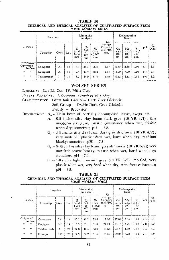
TABLE 20CHEMICAL AND PHYSICAL ANALYSES OF CULTIVATED SURFACE FROM
SOME GORDON SOILS
WOLSEY SERIESLOCALITY :
Lot 25, Con. IV, Mills Twp.PARENT MATERIAL : Calcareous, stonefree silty clay .CLASSIFICATION : Great Soil Group - Dark Grey Gleisolic
Soil Group - Orthic Dark Grey GleisolicFamily - Brookston
DESCRIPTION : A,,-Thin layer of partially decomposed leaves, twigs, etc.A,-0-5 inches silty clay loam ; dark grey (10 YR 4/1) ; fine
nuciform structure; plastic consistency when wet, friablewhen dry; stonefree; pH - 6 .8 .
G, - 5-9 inches silty clay loam ; dark greyish brown (10 YR 4/2) ;very mottled; plastic when wet, hard when dry; mediumblocky ; stonefree; pH - 7.1 .
G., - 9-15 inches silty clay loam ; greyish brown (10 YR 5/2) ; verymottled; coarse blocky ; plastic when wet, hard when dry;stonefree; pH - 7.4.
C - Silty clay light brownish grey (10 YR 6/2) ; mottled; veryplastic when wet, very hard when dry; stonefree; calcareous ;pH - 7.8 .
TABLE 21CHEMICAL AND PHYSICAL ANALYSES OF CULTIVATED SURFACE FROM
SOME WOLSEY SOILS
82
Location MechanicalAnalyses
Ex-
ExchangeableBases
changeHorizon
lye Silt % mae/100a Ca Mg K pH O.M .
Township Conc. Lot sand .OS- Clay gm . Me./ m.e ./ m .e ./1- .05 .002 C .002 100 100 100mm mm mm gm, gm . gm .
CultivatedSurface Campbell XI 15 15 .0 58.5 26 .5 14 .87 9 .59 2 .39 0.16 6 .1 3.3
" Campbell X 15 19 .4 47.4 33 .2 16 .61 8 .09 2 .00 0 .20 5 .7 3 .1
' Tehkummah 1 15 13 .7 54.9 31 .4 14.09 9 .42 2 .43 0 .15 6 .4 3 .2
Location MechanicalAnalyses -
Ex-
ExchangeableBases
change cHorizon % % 0/0 Capacity Ca Mg K pH o
O.M .Township Conc . Lot Sand Silt Clay m,e ./100 m.e./ m .e./ m .e ./1- .05 .05- < .002 901. 100 100 100mm .002
mmmm gm . gm . gm .
Cultivated Carnarvon IV 16 20.2 40 .2 39 .6 18 .96 17 .04 3 .54 0 .18 7 .4 3.4Surface
" Robinson VI 14 13 .9 55.1 31 .0 27 .23 24 .13 3 .76 0,19 7 .0 5 .9
" Tehkummah A 23 21 .6 48 .4 30 .0 25 .80 23 .76 4.89 0 .19 7 .6 5 .3
" Dawson IX 26 17.3i
51 .2 31 .5 23 .36 20 .05 3.72 0 .18 7 .1 4 .9
PIKE SERIESLOCALITY : Lot 5, Con. X1, Bidwell Twp.PARENT MATERIALS
Calcareous, stonefree clayCLASSIFICATION : Great Soil Group - Grey Wooded
Soil Group - Orthic Grey WoodedFamily - Haileybury
DESCRIPTION :
A o- Thin layer of partially decomposed leaves, twigs, etc.A l - 0-2 inches clay ; light brownish grey
(10 YR 6/2) ; finenuciform structure ; very plastic consistency when wet,friable when dry; stonefree ; pH - 6.4 .
A, - 2-5 inches clay ; light grey (10 YR 7/2) ; medium nuciform ;very plastic when wet, very hard when dry; stonefree ;pH - 6.4 .
AB-5-9 inches clay ; pale brown (10 YR 6/3) ; coarse nuciformstructure; very plastic when wet, very hard when dry;stonefree; pH - 6 .7 .
B_ - 9-15 inches clay ; yellowish brown
(10 YR 5/4) ; mottled;massive; very plastic when wet, very hard when dry; stone-free ; pH - 7 .2 .
C - Clay ; grey (10 YR 6/1) ; mottled; massive; very plastic whenwet, very hard when dry; stonefree ; pH - 7 .6 .
BASS SERIESLOCALITY : Lot 7, Con. I, Howland Twp.PARENT MATERIAL: Calcareous, stonefree clay .CLASSIFICATION :
Great Soil Group - Grey WoodedSoil Group - Gleyed Grey WoodedFamily - Renfrew
DESCRIPTION : AO -Thin layer of partially decomposed leaves, twigs, etc.A,-0-3 inches clay ; dark grey (10 YR 4/1) ; fine nuciform
structure; very plastic consistency when wet, friable consist-ency when dry; stonefree; pH - 6.1 .
A,-3-7 inches clay ; pale brown (10 YR 6/3) ; mottled; finenuciform ; very plastic when wet, very hard when dry;stonefree ; pH - 6.1 .
B2 - 7-14 inches clay ; light yellowish brown (10 YR 6/4) ; mot-tled ; coarse nuciform ; very plastic when wet, very hard whendry; stonefree ; pH - 6.8 .
C - Clay ; grey
(10 YR 6/1) ; mottled; very plastic when wet,very hard when dry; stonefree; calcareous ; pH - 7 .6 .
PERCH SERIESLOCALITY: Lot 9, Con. 1, Howland TwpPARENT MATERIAL : Calcareous, stonefree clayCLASSIFICATION :
Great Soil Group - Dark Grey GleisolicSoil Group - Orthic Dark Grey GleisolicFamily - Welland
83

DESCRIPTION :
Ao -Thin layer of partially decomposed leaves, twigs, etc.Al - 0-6 inches clay ; very dark grey (10 YR 3/1) ; fine nuciform
structure; very plastic consistency when wet, friable whendry; stonefree; pH - 6.6 .
G - 6-15 inches clay ; light brownish grey
(10 YR 6/2) ; verymottled. massive ; very plastic when wet, very hard whendry; stonefree; pH - 7 .0 .
C - Clay ; grey (10 YR 6/1) ; very mottled ; massive; very plasticwhen wet, very hard when dry; stonefree; calcareous ; pH -
7.6 .
FARMINGTON SERIES
LOCALITY :
Lot 14, Con. X1, Allan Twp.PARENT MATERIAL : Calcareous loam till over limestone bedrock at depths of
less than 1 foot .CLASSIFICATION : Great Soil Group - Brown Forest
Soil Group - Orthic Brown ForestFamily - Farmington
DESCRIPTION : A,,-Thin layer of partially decomposed leaves, twigs, etc.A1 - 0-5 inches loam ; very dark greyish brown (10 YR 3/2) ; fine
granular structure; friable consistency; moderately stony;pH - 7.2 .
BZ - 5-9 inches loam ; dark brown (10 YR 4/3) ; weak mediumnuciform ; friable; moderately stony; pH - 7.6 .
C -9-10 inches gravelly loam till ; pale brown (10 YR 6/3);loose; stony; calcareous ; pH - 8 .0 .
D - Limestone bedrock.
KAGAWONG SERIES
LOCALITY : Lot 16, Con. X1, Billings Twp.PARENT MATERIAL : Calcareous, stonefree silt loam over limestone bedrock at
depths of less than 1 foot .CLASSIFICATION : Great Soil Group - Brown Forest
Soil Group - Orthic Brown ForestFamily - Ameliasburg
DESCRIPTION :
Ao - Thin layer of partially decomposed leaves, twigs, etc.A1 - 0-4 inches silt loam ; dark grey (10 YR 4/1); medium gran-
ular structure; friable consistency ; moderately stony; pH -6.8 .
B: - 4-8 inches silt loam ; yellowish brown (10 YR 5/6) ; weakmedium nuciform ; friable; stonefree; pH - 7.2 .
C - 8-10 inches silt loam ; pale brown
(10 YR 6/3) ; laminar;
firm ; calcareous ; pH - 7 .8 .D - Limestone bedrock.
84
LITTLE CURRENT SERIES
LOCALITY : Lot 17, Con. X1, Howland Twp.PARENT MATERIAL : Calcareous clay over shale bedrock at depths of less than
1 foot .CLASSIFICATION :
Great Soil Group - Brown ForestSoil Group - Orthic Brown ForestFamily - Ameliasburg
DESCRIPTION:
Ao-Thin layer of partially decomposed leaves, twigs, etc.Al - 0-4 inches clay ; very dark grey (10 YR 3/1) ; fine nuciform
structure ; very plastic when wet, friable when dry; stone-free ; pH - 6.5 .
Bz - 4-8 inches clay ; very dark greyish brown (10 YR 3/2) ; veryplastic when wet, very hard when dry; stonefree; pH - 7.2 .
D -Shale bedrock.