-noom volcanic activity in the aleutian arc - alaska...
TRANSCRIPT

-noom mmILIICBe Volcanic Activity in the Aleutian Arc By ROBERT R. COATS
C O N T R I B U T I O N S TO G E N E R A L G E O L O G Y , 1950
G E O L O G I C A L S U R V E Y B U L L E T I N 9 7 4 - 8
Including a lirt of aN Lown volcanoes and rr summary of activity between 1760 land 19.48
UNITED STATES GOVERNMENT PRINTING OFFICE, WASHINGTON t I950
IJNTC&D STATES DEPARTMENT OF TRE lNTERIOR
tkar L. Chapman, m w y
GEOLOGICAL SURVEY
W. %. Wrather. Dfrecfar

CONTENTS
Abetmot ,,,,, ,, , , , - - - - , - - , - - - - - - - - - , , - - , , - - , - - , - - , , , - , - - - , , , , - , , , , Xntmduation ,,,,,,,,--,,--,,-----,-- *--.---------,---.- ---.- ---..- Diatri bution of volanoea ,,-- me -, me - - ---,-,--, - -- -, -, - -, ---. - -, - -, , , Data of historio e n r p l o n ~ ~ ,,,, ,,,, , ,,- ,,-- --- - - ,- ,. .- , - -- , , . -- Periodicity of erupti~ns,,,,,,-------------,-----,-,.--.---~--.----- Nature of volcenio activity, -,--------,-,-,-,,,----.---",-.m--p----m
C P d e r ~ ,,,, , , , , , , , , , , - - - -- - -- - - - - - - - - - - - - - - - - , - - - - - , - , - - - - -. Yoloanio dames -,,--- - -- - -- - - --- -.. +- - +-- - - -- ,- , -- - , -- - - - , ,, , Petmgraphio c h a w of the volcanic mb,, ....................
=lation of volcsnbrn to Btructure ,,,,,,,,,,,lalalalalalalalalalalalalalalalalalalalala,,,
'Referenass ~iced,,,,,,,,,,,,,,---------------,--------------------~- Index- ,, , , , , , . . , . . , , . , , . , , , -- - -- - -- - -- - - - - ,-, - - - -- - - -. -. . , , , ., , , , , ,
Ptam I. Map o t the Aleutian Zdsndn ~ n d the A b k a Penjnsula, showing the loation of the prinaipal voloanoaa- -,-,---,------ Tn poclret
hawm 16. Five-year moving average! of nurnhrn of wlcnnoea in m p tion in the Aleutian arum ,, , , ,, , , , , - ,. , , ,---------, -, -, 42
TABLES
TAB= 1. VoIcanaee of the Aleutian are .............................. 98 2. Bummary of volcanic activity in the Aleutian am, 1760-1948, fa pooket 8. Calderas of the Aleutian arc,, , , , ,, , ,,,,, ,, , ,- - , - , , . ,, - - - -- 48


VOLCANIC ACTIVITY IN THE ALEUTIAN ARC
At Iewt 76 major volcanoes, actlve and exttnct, haye Been recognlmd in the Aleutian arc, estendlng from Baldlr Island on the wwt to Mount: Spurr on the east. Of thme, 36 are indicated aB hadng been active slnCe 1780. When plotted agalnd time, the activity of the an: shows some nl- of periodicity, the intern18 between maxima being multiglm of 20 gears. In U s report the geographic positiow and altrtndea of all the known volcanoes are tabulated, together with all known eruptive activlty between 1780 and 1948. The kind of activlty that haa characterfied the arc b dmrfbed briefly; a list of 17 calderas, 9 of them hitherto unmentioned in the literatnre, f ~ l given; and the relation of volcanim to the Btmcture of the arc is reviewed.
This report is intended ta present a brief summary of the present stah of geographic and volcanologic information mnceming the v o l c m ~ of the Aleutian arc. It deals with the place, time, and nature of the activity of those volcanoes whom fmi of srupkion still are easily discernibIe and whose products form conspicuous, indhid- ualimd landscape features at the present day. The term tLAleutim am'' is here med to includs the entire arc of tha Aleutian Islands and its atnrctural d n s i o n s , the Alaska Peninsula and the Aleutim Range. Of the volcanic arcs that fringe the Pacific Ocean, that which
sbtches from Buldir Island to Mount Spurr is one of the least h o r n . Remoteness from centers of population and the disagreeable climate have combined to discourag~ geologists from undertaking the study of this chain of volcanoes. The energies of Government geologists have been largely focused on problems that appeared to be of more immediate economic interest, and from this standpoint there was little jmtXcation for the study of these volcmoes. In the eastern part of the arc, studies have been made of mineral deposits and of the occur- rence of petroleum in the older rocks that form the foundation on which the volcanoes sit, but in the western part of the arc, in the 'Aleutian Islands proper, there appeared to be little to beckon the prospector or to justify geoIogic studies intended to assist him.
Until the middle of the nineteenth century, moat of the infomation on the volcanoes of the arc had been derived from the more or less
85

wmal obeewations of gealogista or &hex scientists attached to several exploring expeditions; ~ information waa summarized by Grewingk (18501, who% compilation has been been0 most useful and accessible mum of information on the Aleutian an: to that date. Since the publication of @rewingkb volume, the principal m m of infoma- lion have been the repom of Dall (1918$, of Beckar (1898), and of several Suva y geologists, who, while engaged in petroleum investiga- tions on the h k a Peninsula, made incidental ohmations on the volcanossl. l%pecially worthy of mention are W. W. Atwood, W. R. Smith, A. A. Baker, R. S. Gappen, and F. H. MoffiL The famous eruption of Katmai in 1912 led to much careful work in that a m by G r i m (1821), Fexlner, and their assmiah The events of the went war have magnified the importance of the
Aleutian arc: in the geography of war and paw. Enormous sums of money have been spent in the development of army and naval bases and of airfields adequate for beav-y bombers and transport pl~nes. The chain of bases sxtends the entire length of the Maska Peninsula and the Aleutian Islands. In these eircumshnms, the tempom1 and spatial distribution and the nature of the volcanic activity along tho arc become of considerable importance to those who are responsible for the installations and for the personnel in this area, which during the war was, in all probability, more densely populated than at any time in its previous history.
importance of a howledge of the volcanoes of the are was emphatsiead dramatically by the eruption, beginning in June 1848, of a mall cone within the great caldera of Okmok on Umnak Island. As a consequence of this eruption, which was reported by Rabinsoa (1948), the United States Geological Survey undertook a program of voIcanologic studies in the Aleutian Islands and the Alaska Penin- mla. This program began in the %dl of 1945, The assembling of a11 amilable data on the earlier volcanic achiivity was considered a necessary preliminary to field work, and this report represents that compilation, modified to some extent by the reaulb of field work done in the summers of 1948,1947, and 1948.
The writer's fieId work has been limited to the western Aleutians; therefore, statmeats concerning other parts of the arc are based on published information, on a study of aerial photographs, or on in- formation contributed by colle,agues in the Geological Survey. The autho~ is particularly indebted to Frank 8. Simons, who worked on Great Sitkin; David M. Hopkins, who worked on Umnak; Frank M. Byers, Jr., who has mapped extensively on Umnak, Wnrtlask4 h n , and Akutan; and George C. Kmedy and H. H. W~ldron, who pro- vided information concerning the activity of Frosty and the volcanoe~ of the P1bv1of area.
VOLCANIC ACTIYITY IN THE ALEIfiIAN ARC 37
DIBTRIBWION OF VOLCANOEB
The known gedogio record in the BJmtian arc extends, with grmt gam aa far back as the lah Paleozoic; it is dominated throughout by volcanic m k s and sediments derived from them, The gaps are due in part rto conditions unfavorable for the preservation of fossils, in part to a pancity of exposures, and in part to incomplete geoloaio studies. -use of limited exposures, little can ba said about the geographic distribution of the older volcanic activity, but the youngest cones, as ha9 been prePiously noted by many observers (Capps, 1934, p. 1461, are restricted in their spatial distribution with respect to tho axis of the arc (pl. 1). In the wastern part of the arc, as far east as Ahtan, th,hese volcanoes tend fm lie to the north of the older volcanic rocks of the Aleutian Islands. Along Unimak Island and the Alaska Peninsulr~ they lie in general along the axis of the peninsula as far norhhwest as Mount Peulik, beyond which the main axis of the peninsula is northwest of the oalcanic arc.
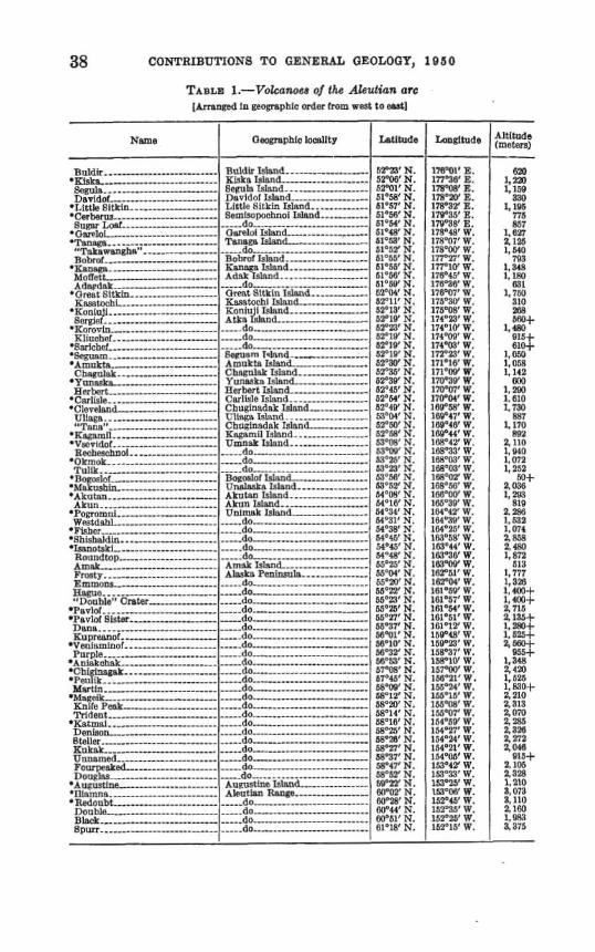
About 76 major volcanoes are slpread in the h a d arc that extends about 1,700 miles from Buldir Island, eastward through the Aleutiaa Islands, along the Alaska Peninsalm and the mainland of Alaska to Mount Spun. Both active and extinct volcanoes are included, but all form independent structures of considerable size and either are h o r n to have been active in historic time or ahow featurea indicating that they were probably act i~e in Pleistocene or Recent tima Most of them are shown an the accompanying map (pl. I), and a11 are listed with their heighta and pasitions in the following table. The latitude end longitude given refer in some instances to the highest point on the caldera rim; in others, to the highest cone occupying the caldera. The 36 vobanma marked with an asterisk (*) are be- lieved to have h e n active in historic t i m e t h a t is, since 1780. The narnaa of numerous upp posed volcanoes that have appeared in
&a litmature have h e n omitted from the fowgohg list; suficient in- formation is now at hand to d i s c d i t many reported discoveries. Some of them were probably due to the inaccurate location of actual volwoeq others to a confusion in names, and still othem to the mi+ taken identification of fog streamers and cloud caps as eruption clouda. h many earlier lists, too, actual volcanic cantem in fwnarolic atages have been rep* as active volcanm bemuse of the confnsion of fummlic &earn with an eruption cloud. For this reason, some volcanoes for which eruptions have besn reported are here removed h m the CJI~SS of ~ctiw aolcanoea
Sitignak Island, listed by Sapper (1937, p. 588) on Grewingk's au- thority as th8 site of an eruption in 1716, does not mmpond with any existing island, as Sappr himself remars; nor does %t Island, which Sapper suggests rrsr the most probable site of the reported emp
CONTRIBUTIONS TO GENERAL GEOLOGY, 1010
T A B L ~ I.-Vdwnw of Zlis Aleutian ore In -pale order lrom rrsst ta srrt]
Name
B* *.--,.,...,----- mm&, , - - - - I - . - - Bew ls....--. D i d - I .
*Little Gltkln ,...,-,. mCmhrus ..--..---..I
~ U R H F ~ ~ ! ---- . - - - - m O ~ l ~ i ...------------ *Tan* .-...--.---------*,-.- .,,------
1 .,,....,..-- mKnnRpa ..----......-.. MOT?-tt I - - - - - - . I . Arlopdak - -
*Or,,nt Sit- ----,.,..,--- K w w h
aKoniu]i ..-.,-.,.--- R e , -
.Korovin ,,..,.-...--- lilluchd .---......,..,
*cS$rleh~t -,...,..--- * S m m ----- m . 4 m u k t r Chapulak --.---,,,-...
* Y U ~ I L F ~ B Rrrlu.rt .,-----------
wCnrlislv.. .-- ,,. * C ~ ~ T I . ~ H ~ L ..,-------
Cllnpn . . . - , , ,, - 7 t~t:rP__--.-------------
K : -....,.,, .Vwv~dol.,,.,--,.
H r c h t ~ c h a o l . - . - - - . - . . - - - ' O k ~ o k ..----..--.--.---------- TuILP .._-----..... .. ..... -
mlloaoslol ----.---I-I h k *Akutnn ..,,...,,,--,, Akun . . 2 , - , , - ,
*Yomtrmni Wvutdnbl ...,..,--------
' l r~bcr ........,.,,,. n$h~sbalrila.. 'Isnnotakl-,..--..--- . ---+
Rour~qitop Am& . . . . - - .... Frouty. ,-,---.----..-....,-- Emmn- ..,-..,.... a n p u n , . . . , , '41hub!~'1 C, -....--
*Pr~vlnf . . - . mI'nulol $latea .,, ]Inns ...--+.--- K - -
*Vsnlammof ...-,... I'utp!e.-- --------------
*Aninkchak ,..,..,.------- *Cbimsgsk ...... e l . . r
1 K n ~ f e P w L .-..-..,. c t
' K ~ t r n n i . ., Tleniuon- .,....,. t o . . I - - Wt~t~nmetl----,---~--- ~ ~ ~ ~ a k e d - - - - - -
&xm~Wa WltY
Rttldlr lshmd - - - . . , - K h k ~ bland ------------*" 6rnlln Tdmd .-..-,----- Davlrlol 1 s l a n L -,-, 1,ictlr. Ritkul rshnd ...,..,...- Gemimimchnoi Island . - . . . ..--- .............. ..... do .------
h r e l o i ~slxnd .-.-...,..,,- Tans~g Ishod-- ,--....-
--..do -----.......------ Bobmi bland ..,.,.....,,- K w Islnnd . . , , Adnk Tsl~nd.
.-_..do Great Sftkln hhd ..,. Ra~?torhi Isbland--.. u j I n - - AtC3 IRIIL~ICI ..-.,.-, ...- (lo . d o , - . - ..... dn BBI1Um T-hrtRltd -....,.,- Amukta I s l a n d - - ............. Cl~~cu lak Ialsnd ,.. Sunaskn l s l a n r l -,,...,.,- nrrhert ISlRnd .----,-------, I:nrl~sle Island .......,.-..,- C h u ~ I n ~ d a k Island a d . . Chrl~inkdnk Tsland - - Kspnmil tslen4. .-..----.-- a 1 1 1 1 1 . .
,-..do ---..do .-...+...-.---.- ....- du ----. -----I--- BopmIoI I s l s s L --------.-- I n a n d AhrjtKn ldmd . . A I Unlmak Islund ----,,-,. +.--.do ..... ..... rlo ...-,--.,,.*,------ d o ..... do -,,,-,..._.--- ---.do -------...... ..--- Amzk I s h L ---.-.,...-.--- A h k a Peninsah ....--,.-,---
----.do -.L2..-..,..---.,.,. d o ..-.do -.--..--.-.-. d o - - d o ,-.., -. ,.da .-..---.-..---- d o _---do ,,-------.. -.do -------------- .--.do ---------- --do --...-....... - - d d o . ,,..-
rlo -----_-.-,, d o - - d o . , . . , ..... do - - d o - - d o - - ,,do -.-.......,.., ---do
WB' N. S P M ' N. 5 2 W r N. 61'58' N. al057WN. 5l05i?' N. jlmM'N.
I ~ o r ~ a l s s .--,-,...,.....,,. o A ~ p u ~ t ~ n e . . gIll~imnr& ._--,_..*------ d u t
noublo , - L k Bpurr ..,.------
siors* N. 61'3' N. 51":~2 N. 61-55' N. ESo55' N. 6 1 N. ht"sV' N. tZ0I14' N. W11" N, 2 . P l O ' h'. 3 ' . 5"LW N. OTIQ' N. 52'19' N. 5 3. 52'3.5' N. 6930' N. b2'45'N. 62'44' N. 6Z04V N. V'fi'M' N. 2 N. bT'A' N. 3 ' . b3"rNl' N. 6ca2'~' N. b1'23' N. fi:IUM' Y. 5 N. 4 N 1 ' , 6 4 9 8 N. M031' N. 54'38' h'. ' M-45' N. 54'48' N. 6 5 ' 5 ' N. 55"W N. 6 5 ' ~ ' N. $ 2 ' N. 550n1 N. K,"P' N. bh-27' N. bh'37' N. ' . IA01O' N. W"3Y S. wq:a' N. 5:'0(19* N- h7'45'N. b8'W N. 58'12' N. .SSom'N. W 1 4 ' N. 68'16' N. 8 ' ..
17B"W W. 177"T'W. IV'lO'W. 176'45'W. 176"3A' W. 176T7'W. l i 5 9 W W. 176"OR' W. l i d a = ' W. 174°1W W. I74"W' W. 174'W' W. I:?P2I1 W. 171'18' W. 171°4W W. liOSY W. 170"K'W. 7 W 18v"R' W. 1611'17' 8. 1UD846' W. 1AU044' W, 169"42' W. 14S973'W. 1%C03' W. 1M65C03'1Y. l%'W W. Ifis" 5' W. 0 165"39* W. lCda4'2' W. 4 . 1M025' W. 1 ' W 1f::ja44* W. 1G190' W. IRl'W W. 162'51' W. 1fiTW W. 161'5S' W. 1 6 l ' ~ i ' W . 1fi)'M' W.
1 161e51'W. 1Gl01Y W, 1 160'23' W. 158":47' W. 15Yq1O1 W. 357%)' W. 15R02L' W. 155'24'W. I5S01fi' W. ILS?W'W. I55"Of'W. 15495G'W. 164'27' W.
2.8% 3,210 8.073 3.110 2.100 1,m a3ij
1, MO 7113
l . 3 4 H 1 , lHU
K?. 1 1,7W
310 2% w L 4M
&DM 1.0a 1,142
r~ 1 2W 1: 6t0 1,730
F.V7 1,170
P91 1,1111 1, WO I , O i 2 1,252
m+ La36 1,293
s18
? 1,0i4 Z W 2 4UJ 1,872
AI:I 1,717 1 32R
I :':::$ 4 711i 4 1 . d 1,5W$.
l ,aa 2,4573 1, U25
2:;' 4313 a070 2 3-5
WOW N. 154'24'W. %On' W. 154m?t' W. W"3i' N. 154'06'W. 4 . 4 .
d o ,.-...........--..-, 1 A Aleutian Rawge. .-,,,
d o . do , . . .
..... (10 - . . . . . . - - - +*--- do----- , .
3%: 2,046
815+ a 105
UhSY N. 1>T0U' W. . I . WPUY N. 153'05'W. 0 % ' N. 15145' W. cllP44(*N. 15213j'W. 5 N 152'25' 1V. 1 1 . 152015' W.

VOLCANIC ACmYJTY IN THIM ALEUTIAN ARC 39
tiaq appear to have been the sits of any p1ogically recent volcanic d p i t y . Tha eruption reported by arewingk probably should have been, and is here, attributed to Little Sitgin.
Adak Island (Sapper, 19'27, p, 8381, given in some c~mpil~~tim aa the location of a so-mlled White Mountain or White Volcano active in 1760 and 1784, has mrhinIy not been the site of any eruption in geologically recent time. The ascription of the White (Belap) Volcano to Adak is probably due to a misreading by some geologist of an early mport by Vasyutinsky. This interpretation is guggyted by the wording of the translation of his report by Jochelmn (1933, p. 71, in which it ia not made quite clear whether the mention of the White Mountain refera to Adak TsIsIand or Great Sitkin Island. The Gnat, Sitkin volcano is much higher than any mountain on Ad& and, with its permanent glaciers and large snow fields, merits the ad je~t ive t'whitan
Mount Dutton (Medvenikovsky), at latitude 65'08' N., longitude 162"04' W., has bean described as a volcano (Sapper, 1927, p. 341), but nccording to Q. C. Kennedy and H. H. WaIdm, who mapped that area in 1948, it is not volcank Moreover, saaeral volcanoes are mi$- tak?edy indicated on a map a~l~rnpanying a report by P. S. Smith (1939, pl. 16) 1 Kagahkrt Island is certanly not the site of any vol- cano, Conical Mountain on Atka Island is not volcano, and Mai Mountain-amording tm Jamb Fresdman, who worked in the area- is not volcanic. Walrus Peak (Moorshowsky), aE latitude 54'69' N., longitude 162'51' W., has teen reported (Becker, 1898) as active in 1768 but also is nonvolcmic. The geodetic positions of the summits of the volcanoes have baen
waled f nrm Aleutian Islands FLight Charts 1,2, and 3 of the Army Air Force's 1944 editions. In a few inshncea, more accurate data w m obtained from later maps, principally detailed topographic maps prepared by the Army engineem. The flight charts a h are m u m for mmt of the heights given on pIata I, but more recent information from the Coast and Geodetic Survey haa introduwd a few diffmenm betwcm the f i p w on the map and t h a in the table, which embodies changw made since the drafting of the map. Where summit eleva- tions were determind by the highest closed contour on the map, the value of this contour ie used for the height, with a plus ign I+) to indicate the approximation. As the contour heights on -sting msp am given in feet, the figures in meters are not in even hundreds or thousands. An tattempt was made to determine whether them is any r e g u l a ~ 9
or system to the spacing of active and probably active volcanoes along the principal arc, The distanoes separating sumwive volmoss

40 COWTRIBIJTIONS TO GENERAL GEOLOGY, 1 9 50
shown an plats 1 were tabulated by class intervals of 8 kilometem No welId&ed mode is present. Many of the distances fall in class intervals of 10 kilometers or under ; these distances are appropriate for subsidiary and parasitic: centers about a main focus of eruption. Qther distances fall in cIsss intervals up to 130 kilometers. Grtain diffemces are more apparent when the arc is divided into three seg- men-ne from Buldir to Seguam, one from Seguam to Dana, and one from Dana to Redoubt. In the fi& segment the class intervals bstwwn 66 and 76 kilometem are besE filled; in the third segment those from 48 ta 75 are best filled. OR the average, the volcan6es a,m more closely spaced in the central part of the arc; insofar ns closeness of spacing of active centers is a masare of the degree of activity, this part of the m may be considered the most active segment. As will be shown later, this segment also contains the POI- canoes for which the historic record of activity is most volnminous.
The dates of the known eruptions in the Aleutian arc from 1760 to 1948 tare shown in the "Summary of volcanic mtivity in the Aleutian arc" that constitutas hble 2. Data concerning the past activity of the active volcsnm listed on pago 38 were largely derived £ram thb refemnces given at the end of the report and from notes in three periodicals-the United States Weather Dureau*s Climato10giml Data, Alaska Section, volumes 1-34 (191448) ; VoIcano httem 1-502 (1025-PS) of tha Hawaiian VoIcana Research Association; and the Gitschrift fiir Vulkanologie, BKnrle 1-17 (1914-38), published in Ber- lin. The primary mums of information yere published m r d s ~f ex- plorations containing eyewitness accounts of eruptions, newspaper reports quoting accounts obtained from eyewitnesses, official weather reports and other xientific findings, and 6rsbhmd manuscript reports from observers. The principal secondary sources were mmrtries, obtained chiefly from the technical press.
Numerous gaps and inaccuracies are undoubtedly present in thn information gathered from so many and such diverse soumes. The literate population of the Aleutian Islands, until the beginning of t h e recent emergency, has never been large, and most of jt b m been aoacentrated in a few viaages for the greater part of the year. More- over, the weather is not favorabIe for obsarvations. The same con&- tiom exist in lesser degree throughout the Alaska Peninsula, although them the activity of the s h o n fishermen has provided opportunity for observations that otherwise would not have found their way into the literature. No newspapers of general circulation are publi~hed in that part of Mm& and published local records are practically non-

VOLCANIC ACTIVITY IN THE ALE- ARC 41
existent^ Many of the earlier descriptions of volcanoes are in Russian and have been accessible to the author only in translation.
Oxle probtmbZe source of much confusion in the m r d is the popular tendency to 4 1 the cloud that results from the condensation of watar vapor Usrnoke."' When the accompanying summary of volcanic ac- tivity was compiled, the extent of this confusion was not realized Because of it, an undetermined part of dl records that do not specify the natum of the activity, as well as all the recards that indicate Stsrnokq'F should be regarded with considerable suspicion.
Some valmnoes, that hitherto hnve been l i d as historidly active are themfom relegated to the solfataric class. h, for example, has been reported active by Grewingk and Sappar, but F. M Byem, Jr., told the author in 1948 that it haa almost mainly been in a sol- fataric stage during all of historic tirna Ku kak (Kutlpkhat, Kugak, Rugat} also has been reported in a solfataric stage, and one report of ash eruption (Dorushin, 1870) was doubtfully attributed to this peak; but aa Kukak is deeply glaciated, the report is perhaps erroneous. ,
Still other volcanoes that have bmn listed as active may be a n - sidered suspect. The depth of erosion an Koniuji suggasp that the' report of its activity may be wrong, and the ascription of an eruption to Fisher Caldera may not be justified. Thia ascription is brtd on a statement by Grewingk (1850, pp. 113-114) that is very indddta as to location; however, Grewingk distinguishes dl the other well-dehed' volcanoes on Unjmak I~land, and his mention of white ash suggests. that this may have been the caldera-forming eruption. G m t thick- nesses of fighkolored ash are now present on the slapcs of the mountah around the caldera; presumably they accumulated rtt the time the caldera. wns formed. On the basis of the type of information available, discrimination
between major and minor explosive eruptions is v e q dacnlt, Prob- Aly many inaccuracies that may be attributd to lthis diilidty are p m n t in the summary as given,
Figure 18 shows 5-year moving averages of the numbers of volcanoss in eruption in the Aleutian arc, Successive p i n k were plotted at 1-year internla on the time scale, each point representing the werage number of valcanom in eruption for the year plotted and t h e two pre- ceding and two auccwding years. The points have loeen connectsd by a solid line.
Inspection of the graph indicates fairly well d&ed maxim in the years 1768,1790, 1828, 1908, and 1929. The corresponding saccessive intervals are 22,38,80, and 21 years, respectively. The curve suggwts,

42 CQNTRTBWTIONS T O GENERAL GEOLOGY, 1950
alm, that the higher the peak of activity, the longer the perid of relative mpcm be£ ore the next maximum, but several objbiom may be r a i d against the uneguivocal ameptgnca of the apparent demon- stration of periodicity. 1. For the period of the Russim occupation of AEaska, most of the
recorded information concerning volcanic eruptions is in the scientific publications rmulting from tt very smaIl number of exploring m e - ditions. Two of these expeditions, those of Billings and Liitke, coincide approximately with two maxima indicated on &we 16. The times of other expeditions, however, show no discernible mlationship to maxima. . 2. The long and nearly complete hiatus in the activity of the west-
~01~1tnm mg& by the Marks in the summary (table 2) ffom a b u t 1830 ta the first decade of this century m y be merely a
DhT E
FIG- lk-Fiv~-year moving averam oi numbrs oi volcauoes in eruptlon fn the llleutlan are
gap in reporting, due ta the relative infqn&ng of travel in the weat- ern part of the arc during that period.
a. The well-known high fquency of acthity on the part of Makushm, Shishaldin, and Pavlof is obvious from an inspaction of the summary. Gxewingk recognized that the mountain^ toward the eastern end of the arc are, on the average, higher than those toward the west. For mountain8 in the same stage of erosion, this may in- dicate more frequent activity, a longer history of activity, or more material erupted per nnit of time. The apparsnt periodicity indicated by figare 16 is the periodicity
of the activity of the arc .as a whole and not of my individual volcano, h~tasmuch as the volcanoss whose activities are repre~nted by one maximum on the chart a m not idantical with those represented by other maxima.

Ailthough the study of the volcanoes of the AIentim are is far from completed (many of them have not yet been examined even in a man- naissance way), certain generalizations based on the work done to date may be dered with considerable confidence that they wiU not be in- validated by further work. The older volcanoea of the arc warn to include both shield volcanoas,
characterized by many relatively thin flom, wit6 a ma11 proportion of fragmental material, accumulated on slopea of 1aw declivity, and stratovolcanoes or composite cones, made up both of flows and frag- mental materid, the sIopes of which approach the angle of repose of the h p e n t a l materiaL T h e major active volcanoes of tho am are without exception composite cones.
A striking featnre of the sletutian arc is the premnce of many calderas, some of great siz& For the purpose of this reporf the defr- nition of Williams (1941, p. 242) will be gdophd: "Calderas are large volcnnic depressions, more or less circular + * * in f o m * * *." The lower limit to the diameter suggested by Williams is 1 mile. The list that fallowa includes 811 calderas known to the writer at the date of writing (May 19491, but others doubtless will be discovered, espe- cially where e d o n has s lbd the characteristic tapographic form sufficiently to disguise iS origin. Many of the calderas in the list have been seen only from the air or in aerid photographs, but the c h a w teristic form and relation to the structure exposed in the rimming cliffs are seldom ambiguoue.
I One nffum h d l m h dlm- where t a o figarpsi sivaa, Faldapa Is notsb eIIIptlrs1. Exmined In the field since 1846 by the writer or hrs oolleapuea of the U. S.%eolodcni B u r n .
t Cerborus VoIrano (p. 331 Is a ywnger mtd Bane in Pemimnochnoi C a l d m Suanrtoat llea wWe It. a Kanogn Volmeo (p. a) fa a y c w e r central cone in W a r n Cdd- (~mts: iw7. p. 88).
~ ~ ~ t l o n
U. 8. Coast Pnot, A M m , p t 2, 1847. 1680.
Dunn solrert, 1% pp. M- Maddkn, A., IP19 pp. 28&B8. xfncb, R. R., 1936: pp. 186IBO,
Wddmn E H pemma1 am- rnuaici~o~, 184.
Knappan, R. 8., IBaB, pp. %POI. Do.
Bmitb W. R., lWb, pp. 198-118. aringi, R. F., iar,
Wmme a-hlo M i t y k!%z I)avldd-. ..,--.-,. ., Zittte8ttkIn ..-.,,.--- Bamimpochaol .-.-...-- lhn~.@ 1 ------=-+*-------- ~Takawrnghm" 2 --*em-
Kmhton l a -___A_-
i Yunmka ,,,,-
O k m k * -.,. ,. ..,..,- MaRusbln t ...,,.,,- ~ k ~ t a n a ,-.,, Piyhrr .......,..--- .,, Frosty (MonbM) 1 ,-,-
Veulmhol,..,,,, l'urple ...-.,,,,,.,- A n l ~ k c b k ,,-,,. E n t o ~ u l .....,.,,.,...--
Davldof Mmd ,.....,. Little Pltkfn Islmd .....-- Rrrnlmpochnoi I s h d .,--- Tmnm I ~ l m d ----------
1 .---. dd .---------------- KBnnRa Island .-.,----- n t k n I4snrl..._---_-_ Yttunska I s l a n d , -
OmnaR lsTsnd - Unslsska I s I d ---,-,- A ~ , I U ~ I S I ~ I ~ ..--- I-nimRk 1513~d .--- AI~sk8 Pwlnwls ...---
,--do--- - d o - , --_do -- d o - - -
2.4 ..-.- 4.6 .----.-. 6.1 by 7.6- tkk ----- 32+. .--- 4 4.6& 2.9 by 2 L
12 --,----- 2.4 by 8.2- a 10 by lI--- 6.6
8.4 -.---, 2.7 by 2.5.- U.lby B.C. 2.1 by a..,

The -galtion of m& of these caldema mmot be ragadd as a mry ditEcnlt achievemen& given the availability of detaild b p graphic maps or of aerial photographs. Whers no sourn of infor- mation is given, tbe writer is the q n s i b l s mum; otherw+ recognition of the caldem is d t e d to the first h o r n h r v e r de- wribing it as such or, in the case of discoveries get unpublished, to the first observer known ta tha author to have recognized ita origin, regardless of whether he m f e d to it as a caldera or B crater.
It should be noted that &e dimensions given are minima, scaled to the. base of the lowest aiccessible part of the bounding cliff. This accounts for the fact that many of the dimensions are smaIIer than those in tha original reports referred to.
The farm "volcanic domen is used to mean tr steepgided viacow pro- trusion of lava forming a more or less dome-shaped mass around ite vent. (See Williams, 1932, p. 59) Such protrusions are common, a~ Powers (1916) has shown, in the vicinity of many volcanm of the .circum-Pacific zone; mmmonly they mupy the summit crater and pat a temporary or permanent halt to the activity of the mne. Othem f o m on the flanks of tho volcano. Tha vol&c domes of Novarupts, near Katmai, and of BogosIof are wen known; others have been d+ scribed from Adak Idand (Coats, 1947, pp. 81-82) and from Great Sitkin f gland ( S h o w and Mathmson, 1947, p 63). F'= M. Byera, Jr., according to a personal mmmmication, has raog&d an obsidian dome on Umnak and W. F. Thompson, Jr. (1949, p. 480), a dome in the crater of Mount Augusthe. Doma am known to be p~e98nt on Buldir Island, on Bobrof Island, in Klinchef Volcano, and st the mumnit of Roundtop on Unimak. Miany "plng~'~ mapped by Raap- pen an the flanks of Venkminof and AnFnkchak a m probably do-. O n tha whoIe, however, domes are m in the Aleutian a m compared, for -ample, with the southern part of the C d e Range- in Oregon and California,
The volcanic rock of the Aleutian arc h g e from alipine basalt to rhyolite. They include basah charackkd by olivine and andmitm without olivine, in both of which hornblende and hypersthen@ mur separately or together. Relatively high gercentagea of conspicuous calcic pIagidase cr~rsta1s and usually less conspicuow green augite charttchrize mod of the rocks. Those that are mmpmtively rich in silica, such dacifes and rhyolites, are much JEW plentiful ; most of them am prewnt either as small bodies of highly g m lava or as blankeh of light-colored pumice.

VOLCAETZC AtXWt!tT W THE ALEUTIAN ARC 45
RELATXON OF VOLCKNIBM TO BTRUC'XZTRN
Tha most mnqimous mtive element in the atntctum of the 'Teutian arc is the p t curdinear ridge extending eouthward and wastward to Attu from f i e Alaskan mainland, where if mergea at ths northeastern end with the AIaska Range. The ridge is notably wider at the eastern end than at the westen. From it a branch about 800 miles long extends northward and weatwad from Semisapochnoi Island, forming a submarine mountain ridge rising in places 12,000 feet abwe the sea floor.
The main ridge is bounded on the north by the lowlmdn of the Alaska Peninsula and by the Bering Sea. The a a s b psrt of the Bering Sea, as fa r west as a line extending northwestward from Uni- matk Pass, is very ahallow. The western part of the Bering Sea i8 deep, and large amas of the bottom form extensive plains at depth close to 9,000 fathoms (3,700 meters). On the south, the ridge of the Aleutian Islands is bordered by the Aleutian Trench (Mumy, 1945), a typical marginal deep extending to depths of about 4,200 fathoms (7,700 meters), In general, the volcanoas are supe~cirrl stmctnm, built upon a bas+
mant of Tertimy and older rocks that is expcwd at intervats through- out the length of the arc. The nature of the structures that have d e h h n e d the p i t i o n of the eruptive centers can be datermined in few places. Some writem have thought that the line of volcanae43, because of ita narrowness, represents the trace of a great thrust pIane or fault, movement on which is thought to be responsible for the fre- quent earthquakes. In detail, the voIcranie line d m not form a per- fectly grnple arc, but consists of segments of different lengths; the included angles between adjacent segments may be as little as 140". Certsin volcanoes, like Bogoslof and Arnak, lie some distance away from the main line, on the concave side of the arc. In the Anialtchak r e o n , Rnappen mapped a tension fault with an east-wmt trend, along or close to which several volcanic structures are &lined; ha con&dered that the site of the eruptive canter was determined by the existRnce of the fault. It is probable that similar relationahips mist elsewhere in the arc and that most of the volcanoes have had their sj tes detellained by minor tensional fractures striking at an angle to the major over- thrast eon= The distance of w vdcano from the major active mne of movement ia probably dependent upon the depth et which such a tensional fracture, originating in and limited ta an overthrust block, taps eruptible magma. The minor tensional faults, by thisl hypothesis, bar s spatial relationship to the hypothetical major active zone simi- lar to that of the "feather fractures'' of CIoos (1932, pp. 887495).
The distribution of earthquake foci (Guknberg and Richter, 1941, p. 25; 1945, pp. 654455) is such that the epicenters of shallow earth-
+

46 CONTRIBUTIONS TO E E ~ T E R A ~ GEOLOGY, I Q ~ O
quakes tend ta ba south of the chain ; thm of TntermediaMepth earth- quakw (deeper than 60 kiIomekers) are in the islands or north of the chain. P t geeme probable that the general sEructura1 picture of the Aleutian Islands, when more information is available, will memble that p m t e d by Gutenberg and Richter for the gtmctwally similar Japanese am [lM, p. 110). The distribution of deep and intarme- diate earthqu& fmi will pmbrtbly fall slung an active zone or surfaca, which will be sllown tb reach ths surface of the crust along the north- ern slope of the Aleutian Trench and to dip northward at a moderate angle.
The older & of the Aleutian arc, in some places dating back to the Paleozoic, am both folded and faulted. The folding in general is relatively open, and dips are moderat@. Major faulh are reverse fauIts, trending nearly parallel ta the tmnd of the arc; the north ~ i d e has'genernlly moved south and up with respect to the south side. In the hiakchak area (Knappn, 1929, p. 2W), the northwestern over- thrust block has generally moved northeast and up with mpect ta the gouthaastern block. Tensional f aultg trending at an angle to the trend of the arc: also have been noted.
REFERENCES C I m D
Becker, GI. F., 1898, Iieconnaisaanee of the gold fields of muthem Ahska, with some n o w on general geology : U. S. W I . Survey 18th Ann. Rept., pt. 8, PP. 14-6.
Camls, 8. R., I W , Notes on the geology of the Alaska Peniosdla and Almtian lalands : U. I. Cfeol. gurney Eull. 857-D, pp. 141-153.
Glm, Ernst, 1852, "Feather jbints" as hdicators of the direction of movements on hnlts, thrum&, joinb, and magmatic contacts: h'at. Acad, Sd. Prm., pol. IS, pp. 387-395.
Coat#, Robert, 1947a, Geulogy of northern Ad& bland: W. S. GeoL Rumeg Alas Ban Volcnno Iuve,stlgatIons Rept. 2, pt. 5, pp. M (Ilmlted distrlbutton).
-, 3 W b , Geology of northern Kanaga Island: 73. 5. Geol. Sumey Ala~kan Yolcnna Investlgatlons Rept. 2, pt. 8, pp. EbW (limlted dlstriiution).
-14 W. H.. 1018, Reminiscences of Alaskan volcanoes: Scl. Month&, voL 7, pp 80-80.
Z)dmMn, P. F., 1879, O dektorykh v u l k m : Russ, FL mfn. Oesell. Verb., ad ser., vol. 25, p 44, St. Petemburg trans. by Bf. M. EIlas).
Dnnn, Robert, 1008, On the c h a ~ e for voolcarrtlws : Oattrig Mag., vot Sl , p E4%. Finch, R. H., TW5, Aknhn volcaoo: Zeitsebr. Vnlkanologie. Band 16, Heft 3,
pp. 155-160. CtrewIngk t.nstnntIn, 1850, Beitrag zar KenntnIss der oro$raphhchefl tmd ge-
oanohltlschen Bmbaffenheit der NordwestkIiste Amerikas. mIt dm an- liegenden Inseln, St. Petemburg, K. Kray (prevlonerlg pnbWed in Rnsa. R. mh. Gemell. Verb.. 1848-49).
UrIggs, 8. F., 1921, The Katmal National Monument and the Valley of Ten Thonsnnd Smokes : Scienre, pol. 49, pp. ZSB-m.
Gutenberg, Beno, and Richter, C. F., 1941, Selsrnldty of the earth: Geot. Roc . America Sgeclnl P n p r 34.
-, 1945, Selsm hl ty of the earth : OeoI. Soc. AmesIca BulL, vol. 56, pp. tM34E8,

_ VOLCAMC ACMTITP IN THE ATAEUTXAM ARC 47
JmheUon, Waldemar, 1953, Ehtorg, ethology and anthrapolw of the dieat: Carn&e Inst Washington Pub 832, p. 7.
lhappen, R. S., 1929, -logy and mineral r e s o w of the aniakchilk met: TJ. 8. Geol. Survey Bnll. 797-I?, pp. 161a.
Maddren. A. G., 1919, Sulphur on Umlnska and Ahm Islands and near 8tepovak Bag : U. IS. Qeol. Survey Bnll. m E , pp. S29&
Murray, E W., 1M5, Profiles of the Aleutian Wench : CfeoL Roc. America Bnll., pol, 56, pp. 757-781.
Powem, Sidney, 1916, Polcanlc doma in the Paci-Gc: Am. Joor. M, 4th ser., vol. 42$ pp. 281-214,
Rubhaon. Q. D., 1948, Exploring Aleutian volcanoes: Hat. Oeog. Mag., vot 99, no. 4, pp 539-522.
Happer, Karl, 1927, Pulkanknnde, pp. 83%3&2, Rtuttgart. S d a , P. a, Areal geologg of &&a: ,W. S. W1. B m e y Pmf. Paper
P. 80. Smith, W. R., 19% Anlakchak Crater, AIaska Peninanla: U. 8. Qeol. B m e y F r d
Paper 13W, pp. 139449. Tho-n, W. F, Jr., 1949, Obrvatlona in Kamishak, Alaska: Qeog. Rev,,
pp. M 7 1 . United states Coast and Gmdetic Surrey, IM7, U, S5, C h t r t Pilot, Alask~, paft 2. Williams, Howel, 1832, Tbe history and character of volcanic domes: Calif. Dnlv-
Dept. Oeol. e l . , ]Boll., vol. 21, no. 5, pp. 61-146, -, 1941, Calderaa and their origin : Calif. Univ., Dept Cfeot Bci., Bull., VOL
S, no, 6, pp, BW40,

INDEX - m
A- ................................. 88 A~~~ .............*............ Qa ...................... Altlbde d 88; pl. 1
Orldsrw ,,.,........ ..................... 4 a 4
Dmtm Q I ~ E U .................. 404; tnbIe B .............. DLrtributton of wlamm. 3740; PI. 1 Domas, v o l d ............................. H
E u t h q d m -....,....-..-----.---------- 4H8 ................ EmptIm. d m &- sw; &bb 2 perlaaidty of, .,...,..,.-.,..-...., 41-42 1
pdneta of ........................... H
fdmtlhtlon d M l l s n of-.-.. 87, ,aP
m a ..................... 1 hlwmstlnn. muma of...-.....,. 48-47 Znwmtimtlom fn area, M t t m ~ a L - ........... 3HM
psi Tmatlmdwlasmra ..................... S3;pl.x
-*Idty Of -------**-------------- Ct-lf P m P m ....-*...*........*........... 44
hlarewsadted .-.--.. * * ------- w 7 Rwgs, ~ o M a C( ..............................
........... B m , mhtion ot v- tO. 4 H 6 B u d t mUom, how d~tPamIoed .-.----.--- 88
.................... V h m , 8lHtuda OL BS; PI. 1 M*-------------- tabha
m d t l m o f i d e n m - - - - - - - - - - - - - - - - 99 dtstrlbntlm of-. .................... 81M; pl. 1 list of .................................... I lmtion at.. ..................*........ pl. 1 nature ol d M g M .............. table 3 types represaakd ........................ UI
49 0

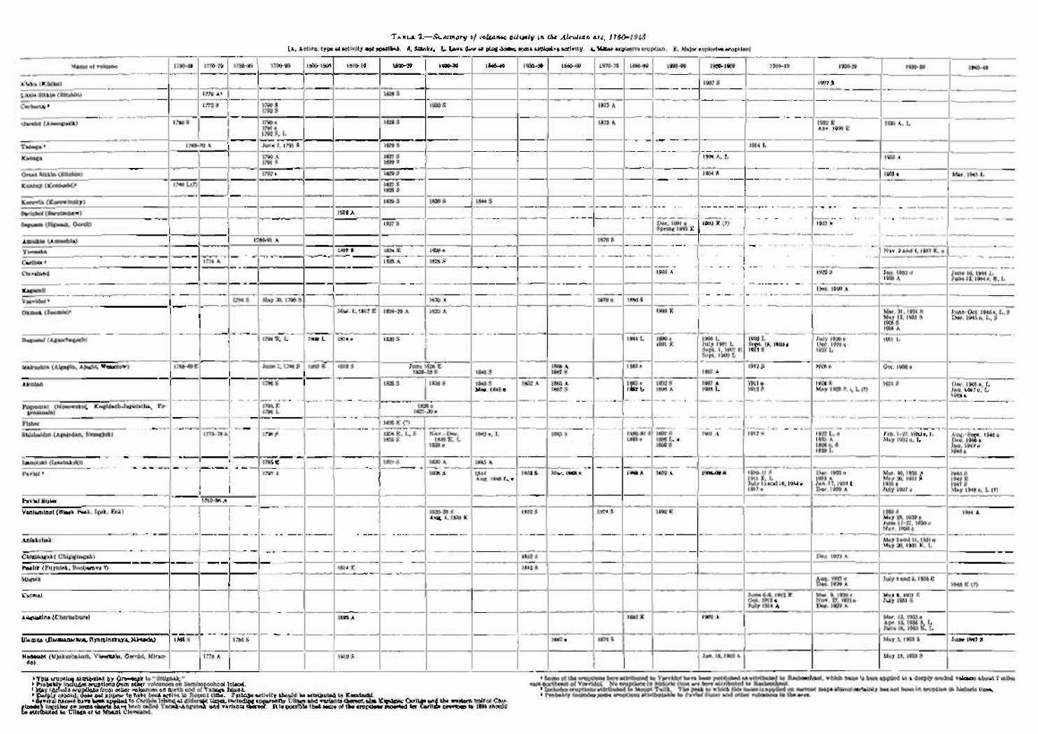
TABLE 2.-Summary of volcanic activity in the Aleuiian arc, 1760-1948
[A, Active; type of activity not speciflrtd. S, Smoke. L. Lava flow or plug dome; some explosive activity. e, Minor explosive eruption. E, Major explosive eruption] - -... . . --- -- - - - -. - -.
I ---
Name of volcano liwm l77tig j 1780-89 1790-99 / lBatlm l n l t l g 1820-29 1830-39 1840-49 1850-59 1860-69 1870-70 1W-89 1890-w 1900-1909 1910-19 1920-29 1930-39 -- .. . - - -- - -- -- -- - - - -- - 1940-48
--
Kiska (Kiiska) -- .- - - -- - 1927 S -
1776 A1 / 1828 S -
Little Sitkin (Sitchin) - - -. -- -- . -- -- -.-A - - a -, - -- .- -. -- - -- -- _ -- .- -. - -- --
Cerberus 1 1772 S / 1790 S 1830 S 1873 A 1 1792 S
__ .. .- - - --- -- -- -- -. . - .. .- . - I - - 1 ~ ---- ~_
Uareloi (Anangusik) 1790 e 1828 S 1873 A 1922 E 1791 e
1930 A, L Apr. 19% E
1792 9, L -- -.
Tanaga 8 1763-70 A June 7. 1791 8 1829 S
I I . ~
1914 L -- - - --
Kanaga 1790 A 1827 S 1904 A, I, 1933 A 1791 S 1829 S - - - --- - - -- -- pp -- _ _
Great Sitkin (Sitchin) 1792 e 1829 8 1804s 1933 e -- - -- - - - .... - ._ ---, - Mar. 1945 L
Koniuji (Koniushi)d 1760 L(7) i 1827 S
- -- -- 1825 S - -.
Korovin (Korowinsky) -. - - - -- - -. -- -- 1829 S 1830 S 1844 S
Sarichef (Ssrutschew) p- -- -- - -- -- 1812 A _ - - -_ _ .~ .... - - ~
Seguam (Biguam, Goreli) 1827 S I Dec. 1891 e 1902 E (P)
--- I -- Spring 1892 E
Amukta (Amuchta) 178691 A I -- -- ~
Yunaska 1817 S 1824 E 1830 e NOV. 3 and 4,1937 E, e . - -- - -- -- . -. - - --
Carlisle 6 - -
Cleveland I Jan. 1932 8 June 10 1914 L 1938 A June 12: 1944 e, E, L
Kagamil I 1 -- -- - -- -- -- I -
Vsevidof 6 May 30, 1790 S .
1830 A 1878 e 1880 S
Okmok (Zoomie)' Mar 1, 1817 E 1824-29 A 1830 A 1899 E
i - --. - -- - -
Bogoslof (Agnschagoch)
I_______ Mar. 21 1931 S June-Oct. l945e L, S May 13,' 1931 S Dec. 1945 e, L, 4 1936 S 1938 A -- ~- ~ - ~ - - .~ .--~.. / 1884 L I 18W n 1 1936 I. / 1910 1. July 1926 e
1891 E July 1907 L Scpt. 18, 1910 e Uec. 1926 e Soot. 1.1907 E 1913 S 1927 I.
-- - I - . - I . . I -- ~ -. - -- -- - - .. ---. .. . .. .- A
~ ~ ~ - Pogromni (Nosowskoj, Kugidach-Jagutscha, Po- 1795 F: 1820 e
gromnaia) --
1 1 _ 1796 L . 1827-30 e ~ . . --. .. -. -- - ~ ---
~ - -- - - Fisher
Shishaldin (Agajedan, Sissagjuk) 1790 d 1824 E, I,, S Nov.-Dec. 1842 e, I, 1865 S 1880-81 S 1897 S 1901 A 1912 S 1922 I., c Feb. 1-27.193'2e, 1, Aug.-Sept. 1946 e 1825 S 1830 E, L 1883 e 1898 L, o 1925 A May 1932 e, L Dec. 1946 e
1838 e 1899 S 1928 o, S Jan. 1947 e 1929 L 1948 e
' - -- Makushin (Algagin, Ajagin, Wesselow) 1768-693 June 7, 1790 S 1S02 E 1818 S June 1826 E 1865 A 1883 e 1912 S 19% e Oct. 1038 e
- -- . -
Isanotski (Issanakski) -. .~
Pavlof 9 1790 A 1838 S Mar. 30,1931 h 1945 S hug. 1846 I,, o 1911 E L 1923 A May 20,1931 S 1942 E
~ u l y l i and 16,1914 e Jan. 17,1924 E 1936 e 1917 S
.- -- - 1917 e Doc. 1929 A July 19'37 e May 1948 e, L (7)
Pavlof Sister 1762-86 4 -1- Veniaminof (Black Peak, Igek, Eek)
-- -
- - I I 8338 S I I 1852 S 1 Aug. 4,1838 E
-- 1930 d I- 1944 A May 23, 193P e June 17-27,1939 e
I Nov. 1939 c
Akutan --
I May 2and 11,1931 o Mav 20.1931 E. L
- - . - - - - - -. I I--- I /-----/1~14- i i Peulik (Puvulek. Bocharova 7) 1852 S I
- 1790 S
Mageik I 1 I I I I I I I I l l I I Aog. 1927 e / July 4aud 5,1936 E Dec. 1929 A 1 1948 E (1)
-- - -
I -- - - - -- -- - - I
Katmai I I I I I I I I---/ June 6-8.1912 E Mar. 9,1920 e May 8, 1931 S Oct. 1912 e Nov 27, 1921e July 1931 S July 1914 A Dec. 1929 A -I
1826-38 S
1838 S I
Iliamna (Ilnemanschen, Ilyaminskaya, Miranda) 117685 / 1 7 8 6 s 1 I I i I I I /1867e I
1 1876 S / / May 5, 1933 S 1 June 1947 S
1845 S
1845 S Mar. 1848 e
-- - - - - - --
I i Augustino (Chernabura) 1812 A
I
I I I I I I -- -
Redoubt (Ujakushatsch, Viesokaia, Goreloi, Miran- 1819 S I 1 Jan. 18,1902A May 25, 1933 S do) I I
1 This eruption attributed by Qrewingk to "Sitignak." 1 Prnhnhlv includes pnintinna Rnm nthnr vnlcnnnea nn Semimnnchnni Island
--I Mar. 13, 1935 e Apr. 15, 1935 S, L June 18, 1935 E, I,
, Ma-y-rnnEiu-d-e-i~;;;ti-~n-srf-r-om- oiher ;olEanoe-s-onno;t-h endo rT-a-iii-a- fsiGd-dd 4 Deeply eroded. does not appear to have been active in Recent time. Perhaps activity should be attributed to Kasatochi. 8 Several names have been ap lied to Carlisle Island at different times including apparently Uliaga and variants thereof also Kigdgln. Carlisle and the western half of Chu-
ainadak together on some charts gave been &led Tanak-Angunak and /ariants thereof. It is mssible that some of the skotions wwrtAd for Carlisle c rev lo us to 1896 should
1867 S
--
a Some of the eruptions here attributed to Vsevidof have been published as attributed to Recheschnoi, which nane is here applied to a deeply eroded volcano about 7 miles east-northeast of Vsevidof. No eruptions in historic time nre here attributed to Recheschnoi.
1 Includes eruptions attributed to Mount Tulik. The peak to which this nameis applied on current maps almostcertainly has not been in eruption in historic time. Probably includes some eruptions attributable to Pavlof Sister and other volcanoes in the area.
- 1892 S 1896 A
1852 A
be attributed to Uliaga or to Mount Cleveland.
1907 A
1907 A 1908 I.
1865 A 1867 S
1883 e 1887 L
-- 1911 e 1912 S
1928 S May 1929 S, c, L (7)
1931 9 Dec. 1946 e, I, Jan. 1947 e , I, 1048 e