pocahontas · pocahontas is an active community and most of the pedestrian circulation occurs on...
TRANSCRIPT
I o w a D e p a r t m e n t o f T r a n s p o r t a t i o n T r e e s F o r e v e r I S U L a n d s c a p e A r c h i t e c t u r e E x t e n s i o n I S U E x t e n s i o n C o m m u n i t y a n d E c o n o m i c D e v e l o p m e n t Summer 2014
PocahontasLandscape Architect and Intern: RDG Planning & Design - Jen Cross, PLA, ASLA and Anne HundleyRecreational Trails
510TH ST
240T
H A
VE
ELM AVE 520TH ST
230T
H A
VE
3RD AVE NW
2ND AVE NW
4TH AVE NW
NE
6TH
ST
220T
H A
VE
225T
H A
VE
1ST AVE SW
3RD AVE NE
5TH AVE NW
2ND AVE SW
4TH AVE NE
3RD AVE SW
NW
7TH
ST
NW
4TH
ST
NW
2N
D S
T
2ND AVE NE
RAILROAD ST
NE
1S
T S
T
NW
3R
D S
T
NE
5TH
ST
NW
9TH
ST
NW
8TH
ST
1ST AVE NW
S M
AIN
ST
SW
7TH
ST
N M
AIN
ST
SW
2N
D S
T
SW
6TH
ST
6TH AVE NW
SW
4TH
ST
NW
12T
H S
T
SW
1S
T S
T
FRONT AVE
1ST AVE NE
SW
5TH
ST
4TH AVE SE
NW
13T
H S
T
NW
5TH
ST
5TH AVE SE
NE
4TH
ST
PRAIRIE ESTATES DR
SUNSET DR COURT SQUARE
4TH AVE SW
NE
2N
D S
T
NW
6TH
ST
NW
10T
H S
T
HU
DS
ON
ST
BENEKE ST
SW
3R
D S
T
SE
3R
D S
T
CLE
AR
VIE
W D
R
N M
AIN
ST
520TH ST
NW
13T
H S
T
220T
H A
VE
RAILROAD ST
1ST AVE NE
230T
H A
VE
225T
H A
VE
NE 4TH
ST
530TH ST
County
C37County
C37County
C37
4
4
3 3 3
0 0.55 1.10.275 milesN
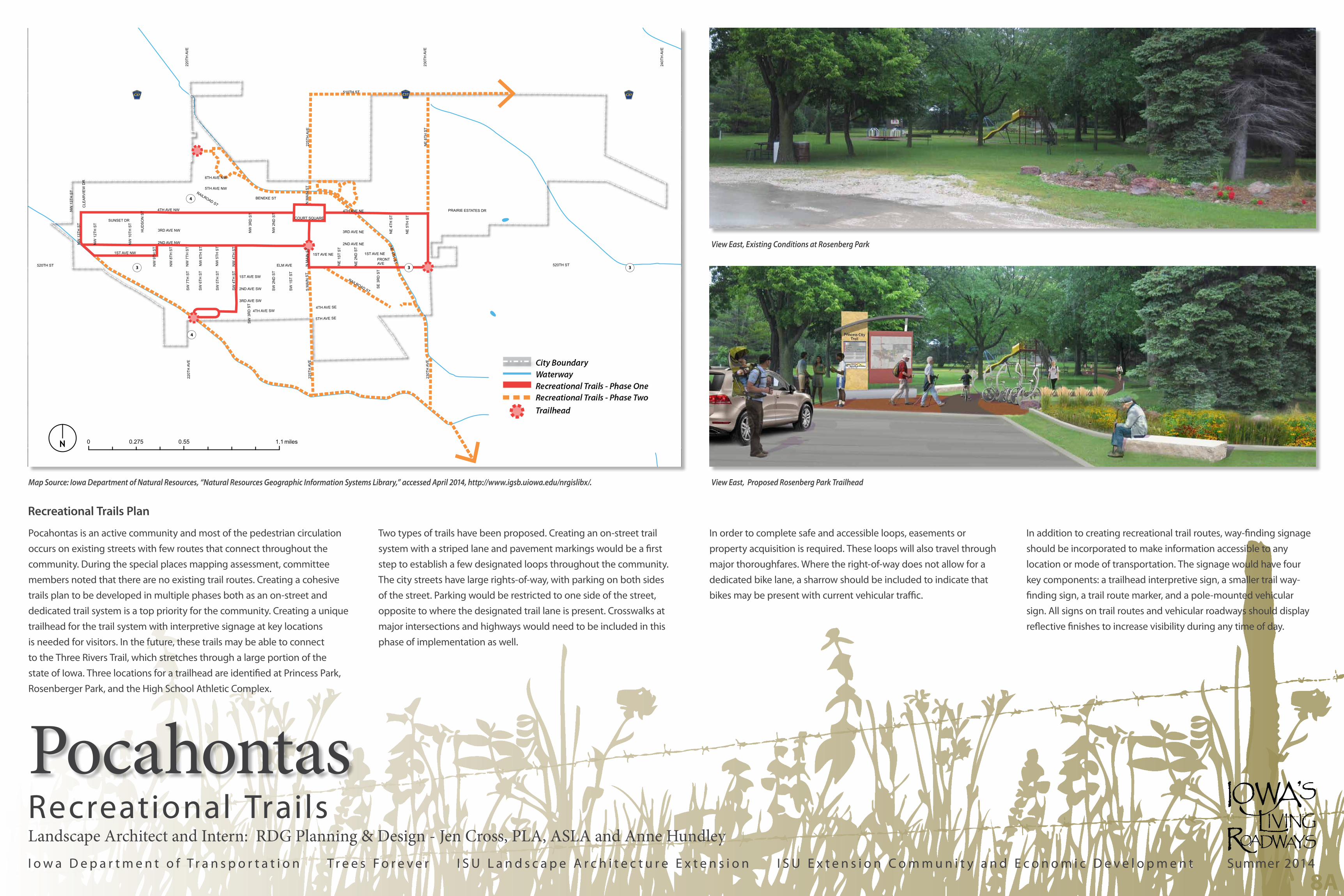
Map Source: Iowa Department of Natural Resources, “Natural Resources Geographic Information Systems Library,” accessed April 2014, http://www.igsb.uiowa.edu/nrgislibx/.
8A
View East, Proposed Rosenberg Park Trailhead
View East, Existing Conditions at Rosenberg Park
Pocahontas is an active community and most of the pedestrian circulation
occurs on existing streets with few routes that connect throughout the
community. During the special places mapping assessment, committee
members noted that there are no existing trail routes. Creating a cohesive
trails plan to be developed in multiple phases both as an on-street and
dedicated trail system is a top priority for the community. Creating a unique
trailhead for the trail system with interpretive signage at key locations
is needed for visitors. In the future, these trails may be able to connect
to the Three Rivers Trail, which stretches through a large portion of the
state of Iowa. Three locations for a trailhead are identified at Princess Park,
Rosenberger Park, and the High School Athletic Complex.
Two types of trails have been proposed. Creating an on-street trail
system with a striped lane and pavement markings would be a first
step to establish a few designated loops throughout the community.
The city streets have large rights-of-way, with parking on both sides
of the street. Parking would be restricted to one side of the street,
opposite to where the designated trail lane is present. Crosswalks at
major intersections and highways would need to be included in this
phase of implementation as well.
In order to complete safe and accessible loops, easements or
property acquisition is required. These loops will also travel through
major thoroughfares. Where the right-of-way does not allow for a
dedicated bike lane, a sharrow should be included to indicate that
bikes may be present with current vehicular traffic.
In addition to creating recreational trail routes, way-finding signage
should be incorporated to make information accessible to any
location or mode of transportation. The signage would have four
key components: a trailhead interpretive sign, a smaller trail way-
finding sign, a trail route marker, and a pole-mounted vehicular
sign. All signs on trail routes and vehicular roadways should display
reflective finishes to increase visibility during any time of day.
Recreational Trails Plan
I o w a D e p a r t m e n t o f T r a n s p o r t a t i o n T r e e s F o r e v e r I S U L a n d s c a p e A r c h i t e c t u r e E x t e n s i o n I S U E x t e n s i o n C o m m u n i t y a n d E c o n o m i c D e v e l o p m e n t Summer 2014
PocahontasLandscape Architect and Intern: RDG Planning & Design - Jen Cross, PLA, ASLA and Anne HundleyPrincess Park and Trail Signage
8B
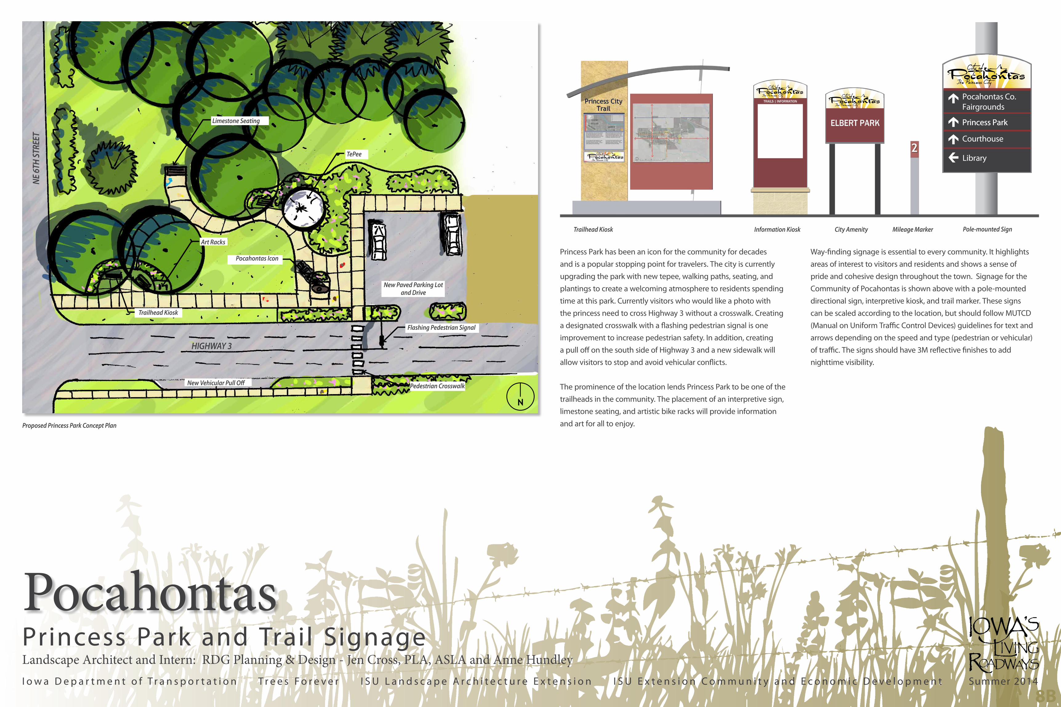
Princess Park has been an icon for the community for decades
and is a popular stopping point for travelers. The city is currently
upgrading the park with new tepee, walking paths, seating, and
plantings to create a welcoming atmosphere to residents spending
time at this park. Currently visitors who would like a photo with
the princess need to cross Highway 3 without a crosswalk. Creating
a designated crosswalk with a flashing pedestrian signal is one
improvement to increase pedestrian safety. In addition, creating
a pull off on the south side of Highway 3 and a new sidewalk will
allow visitors to stop and avoid vehicular conflicts.
The prominence of the location lends Princess Park to be one of the
trailheads in the community. The placement of an interpretive sign,
limestone seating, and artistic bike racks will provide information
and art for all to enjoy.
Way-finding signage is essential to every community. It highlights
areas of interest to visitors and residents and shows a sense of
pride and cohesive design throughout the town. Signage for the
Community of Pocahontas is shown above with a pole-mounted
directional sign, interpretive kiosk, and trail marker. These signs
can be scaled according to the location, but should follow MUTCD
(Manual on Uniform Traffic Control Devices) guidelines for text and
arrows depending on the speed and type (pedestrian or vehicular)
of traffic. The signs should have 3M reflective finishes to add
nighttime visibility.
Flashing Pedestrian Signal
TePee
Pocahontas Icon
New Paved Parking Lotand Drive
New Vehicular Pull Off
Trailhead Kiosk
Pedestrian Crosswalk
Trailhead Kiosk City Amenity Mileage Marker Pole-mounted Sign
Pocahontas Co. Fairgrounds
Princess Park
Courthouse
Princess Park
Library
TRAILS | INFORMATION
ELBERT PARK
Information Kiosk
Limestone Seating
Art Racks
HIGHWAY 3
NE 6T
H ST
REET
Proposed Princess Park Concept Plan
N