· web viewanticipated responses may include: protesting, going to jail for their beliefs,...
TRANSCRIPT

Understanding Our WorldAn Open-Source Literacy-Focused Social Studies Curriculum
Curric
INSTRUCTOR MANUALLevel: Grade 4
Exploring the World
Developed ByChristopher C. Martell and Jennifer R. Bryson
Boston University School of Education
INTRODUCTION

Starting in the early elementary grades, all children should receive regular instruction in the social studies, which includes history, civics, geography, and economics. However, there are real pressures on schools and teachers to increase the amount of instruction in other subject areas, which often comes at the expense of their social studies time.
This curriculum was built to help elementary teachers regularly enact powerful and authentic social studies in their classrooms that will also meet essential literacy goals (linking every lesson to the Common Core State Standards). In other words, it leverages the richness of social studies content to help students learn to read, write, speak, and think critically while exploring the past and present world around them. It aims to make every single lesson culturally relevant, connecting to the racial, ethnic, gender, class, language, and immigration experience of the increasingly diverse United States.
ORGANIZATIONThese lessons are meant to supplement the school or district social studies curriculum. They are free and open source. Teachers are encouraged to modify and adapt these lesson plans for the individual needs and diverse cultural backgrounds of their students. They are only a guide, or perhaps better a “starter kit” to implementing lessons with important disciplinary questions and social studies content. Moreover, these social studies lessons should be supported with rich English language arts (ELA) texts on related topics.
This curriculum is organized by grade level, with an organizing theme, and each grade is color coated for quick reference. Within each grade level, it is organized by lesson. At the beginning of each grade level, there is a roadmap for that shows the individual lesson topics. Additionally, each lesson plan follows the same lesson plan template (adapted from the Boston University Elementary Education Program) and always includes a thought-provoking inquiry question for the students to answer and primary/secondary sources to use as evidence. All lessons for the primary grades (1-2) are expected to be 30 minutes in length and the intermediate grades (3-5) are expected to be 45 minutes in length. However, depending on the pace of your students, lessons may need to span two or more 30- or 45-minute periods.
This curriculum was designed for students in the Boston Public Schools and each lesson cites the Massachusetts Curriculum Framework for History and the Social Sciences (aligned with the national College, Career, and Civic Life Framework for Social Studies State Standards) and Common Core State Standards. However, this curriculum can be easily adapted for other communities, including districts using other state curriculum frameworks. Some lessons are specifically about history and current events in Dorchester, Boston, and Massachusetts. Teachers from other cities/towns and states are encouraged to adapt these lessons for their particular communities.
Understanding Our World: An Open-Source Literacy-Focused Social Studies CurriculumLEVEL: GRADE 4Version 2.1 (2018)
Page 2

HOW TO USE THE CURRICULUM RESOURCESThis curriculum includes three separate resources. The Instructor Manual includes all of the lesson plans, including materials, standards, procedures, and evaluation instructions. The Student Workbook includes all of the student handouts and other materials that teachers need to print for the various activities. The Student Sourcebook includes all of the documents that students are expected to use during the various inquiry activities, which teachers need to print for the various activities.
We encourage teachers or principals to have the materials in the Student Sourcebook color-printed into bound packets, so they can be used in multiple classrooms or over multiple years. If students are using a bounded sourcebook, avoid having them highlight/underline as some lesson instructions suggest.
In this Instructor Manual, each title listed in the Table of Contents is a hyperlink to that specific lesson. This will help you quickly locate each lesson plan.
Understanding Our World: An Open-Source Literacy-Focused Social Studies CurriculumLEVEL: GRADE 4Version 2.1 (2018)
Page 3

GRADE 4Exploring the World
GRADE 4 CONTENT OVERVIEW
We live in a globalized society. Students today can speak instantaneously through the Internet with their peers in China, Brazil, or Nigeria. In a rapidly changing world, it is crucial that we are preparing global citizens who, from an early age, have a strong understanding of the world’s history and recognize the role of the United States within a much larger global community. These lessons are designed to help students develop a spatial, cultural, and historical understanding of the world. Grade 3’s lessons help students learn that the rich history of each continent and the people who live there, but it also highlights difficult events in our world’s past and present. By the end of Grade 4, students should understand the many overlapping world stories and realize that the world’s history is actually composed of conflicting histories.
GRADE 4 LEARNING GOALS
1. Students Should Be Able to Construct ArgumentsBefore grade 4, students have begun forming basic arguments. While opinions are claims that are not necessarily based in evidence, arguments include both claims and evidence. In grade 4, students should be able to use evidence to support their claims. While these argumentation skills may still be developing, students should be able to construct relatively logical arguments.
2. Students Should Recognize Inequities and Their CausesBefore grade 4, most students have developed a strong understanding of fairness. Students are also able to recognize racial, gender, and other social differences (there is evidence that most children can detect racial and gender differences by about age 2). In grade 4, students should be able to recognize inequities and the larger social forces that cause inequities. They should be able to suggest ways to improve our communities to make them more fair and just.
3. Students Should Understand Differences Between Present and Past PerspectivesBefore grade 4, students are beginning to understand that different people may experience the same situations differently. The have begun to examine how people may think differently in the past compared to today. In grade 4, students should examine examples of people thinking differently about the same events in the past and present. They should be able to recognize that people in the past lived in a world very different to today and that impacted the way they understood the world.CONCEPTS
Understanding Our World: An Open-Source Literacy-Focused Social Studies CurriculumLEVEL: GRADE 4Version 2.1 (2018)
Page 4

Synopsis Content Thinking Skills1. Earth While most people will
say there are 7 continents, geographers debate that the number is between 4 and 7.
While most people will say there are 4 oceans, geographers and scientists debate that the number is between 1 and 5.
Maps are tools to help us understand the world around us. There are many different maps that show the earth from different perspectives and present different information.
The United Nations is an international organization where nations make worldwide decisions.
Recognize that maps portray the land and water masses of the earth differently based on purpose.
Identify the names of continents and oceans.
Compare different arguments for the number of continents and oceans on earth.
Evaluate the ability of nations to make worldwide decisions.
2. Africa Humans began in Africa.
Africa has a long history, including several great empires.
Europeans invaded Africa, which caused many problems for the African people.
Africa has 54 independent countries with different languages and cultures.
Identify Africa as the beginning place of humankind.
Compare different African empires’ histories.
Recognize Africa’s contributions to the world.
Identify and compare several modern African nation’s cultures and governments.
3. Asia The majority (60%) of the world’s people live in Asia.
Compare different Asian empires’ histories.
Understanding Our World: An Open-Source Literacy-Focused Social Studies CurriculumLEVEL: GRADE 4Version 2.1 (2018)
Page 5

Asia has a long history, including several great empires.
Europeans invaded Asia, which caused many problems for the African people.
Africa has 48 independent countries with different languages and cultures.
Recognize Asia’s contributions to the world.
Identify and compare several modern Asian nation’s cultures and governments.
4. Americas North and South America has a long history, including several great empires.
Europeans invaded the Americas, which caused many problems for the Indigenous people.
South America has 12 and North America has 23 independent countries with different languages and cultures.
Compare different American empires’ histories.
Recognize the America’s contributions to the world.
Identify and compare several modern American nation’s cultures and governments.
5. Europe Europe has a long history, including several great empires.
Europe has 44 independent countries with different languages and cultures.
Compare different European empires’ histories.
Recognize Europe’s contributions to the world.
Identify and compare several modern European nation’s cultures and governments.
Understanding Our World: An Open-Source Literacy-Focused Social Studies CurriculumLEVEL: GRADE 4Version 2.1 (2018)
Page 6

GRADE 4 FIELD EXPERIENCES
It is strongly recommended that students engage regularly in social studies field experiences to connect their learning inside school to the world outside school. The Grade 4 curriculum covers the world and its history, civics, geography, and economics. There are several field trip locations in the Boston area that would provide an excellent real world connection to this curriculum. We recommend the following:
Mappariumwww.marybakereddylibrary.org/project/mapparium/
Museum of Science IMAX (Greece Secrets of the Past) www.mos.org/imax/
Museum of Fine Arts (Asia, Africa, the Americas, and Europe Collections)www.mfa.org
Boston Children’s Museum (Exhibit: Japanese House, Program: Cultures)www.bostonchildrensmuseum.org
Understanding Our World: An Open-Source Literacy-Focused Social Studies CurriculumLEVEL: GRADE 4Version 2.1 (2018)
Page 7

GRADE 4 PROJECT-BASED LEARNING
These lessons are meant to supplement the school or district social studies curriculum. In addition, teachers are strongly encouraged to have students engage in project-based learning related to the content of these lessons. The Grade 4 curriculum covers the world and its history, civics, geography, and economics. Below are several suggested long-term projects that we recommend teachers use in conjunction with these lessons. These projects may include producing a report and/or brief presentations in the form of poster boards, digital slideshows, performances that highlight the positive and negative aspect to each historical event or person.
Project 1: AfricaTo extend on lessons 4-1 to 4-8, students will research the nations of Africa.
Project 2: AsiaTo extend on lessons 4-9 to 4-14, students will research the nations of Asia.
Project 3: The AmericasTo extend on lessons 4-15 to 4-27, students will research the nations of North and South America.
Project 4: EuropeTo extend on lessons 4-28 to 4-30, students will research the nations of Europe.
Project 5: Global IssuesTo extend on lessons 4-1 to 4-30, students will research important current-day global issues of their choosing (the environment, access to water, health care, hunger, etc.) and present possible United Nation resolutions to help solve these problems.
Understanding Our World: An Open-Source Literacy-Focused Social Studies CurriculumLEVEL: GRADE 4Version 2.1 (2018)
Page 8

GRADE 4 CHILDREN’S LITERATURE
These lessons can be supported with accurate and rich social studies texts within the language arts classroom. Below is a partial list of picture books and chapter books (with topics in parentheses) that we recommend accompany this curriculum during students’ language arts time or in a class library.
Since social studies sometimes involves difficult topics, teachers should always preview texts for their classroom to make sure they are appropriate for their students.
National Geographic Kids Readers: Ancient Egypt (Ancient Egypt)By Stephanie Warren Drimmer
Encounter (Columbus)By Jane Yolen and David Shannon
If the World Were a Village: A Book about the World's People (World’s Population)By David J. Smith and Shelagh Armstrong
The Great Voyages of Zheng He (Chinese Explorers)by Demi and Renee Ting
Hilde and Eli (Holocaust)By David A. Adler and Karen Ritz
Hiroshima No Pika (Hiroshima/Atomic Bomb)By Toshi Maruki
Nelson Mandela (South Africa Apartheid)By Kadir Nelson
Penguin’s “What Was?” History Series (Various Topics)
Penguin’s “The Who Is/Was?” Biography Series (Various Topics)
The Princess and the Warrior: A Tale of Two Volcanoes (Aztecs) By Duncan Tonatiuh
Pyramid (Ancient Egypt)By David Macaulay
Riding on a Caravan: A Silk Road Adventure (Silk Road)by Laurie Krebs and Helen Cann
Understanding Our World: An Open-Source Literacy-Focused Social Studies CurriculumLEVEL: GRADE 4Version 2.1 (2018)
Page 9
GRADE 4 ROAD MAP
LESSON 4-1
Lesson Title: How Many Continents and Oceans Are There?
Inquiry Question: How many continents and oceans are there?
LESSON 4-2
Lesson Title: Which Way Is Up? Seeing the World Through Different Maps
Inquiry Question: Which map is best?
LESSON 4-3
Lesson Title: Africa: Where Humans Began
Inquiry Question: What was the most important event of early human in Africa?
LESSON 4-4
Lesson Title: Ancient Egypt
Inquiry Question: If you could be in any ancient Egyptian social class, which would you choose and why?
LESSON 4-5
Lesson Title: The Great African Empires: Ghana, Kongo, Ethiopia, and Zimbabwe
Inquiry Question: If you could live in any African empire, which one would it be and why?
LESSON 4-6
Lesson Title: Timbuktu: How Trade Shaped a City
Inquiry Question: Why was Timbuktu so important?
LESSON 4-7
Understanding Our World: An Open-Source Literacy-Focused Social Studies CurriculumLEVEL: GRADE 4Version 2.1 (2018)
Page 10
Lesson Title: Apartheid in South Africa: A Movement for Freedom
Inquiry Question: What can we learn from the Anti-Apartheid Movement in South Africa?
LESSON 4-8
Lesson Title: Africa Today: Diverse Nations, Diverse People
Inquiry Question: If you were to visit Africa today, what country would you choose and why?
LESSON 4-9
Lesson Title: The Great Asian Empires: China, Japan, India, and Persia
Inquiry Question: If you could live in any Asian empire, which one would it be and why?
LESSON 4-10
Lesson Title: The Silk Road: Connecting the Continents
Inquiry Question: What was life like on the Silk Road?
LESSON 4-11
Lesson Title: Việt Nam: A Country of Waterways
Inquiry Question: Are the human changes to the Mekong River more positive or negative?
LESSON 4-12
Lesson Title: Asian Megacities: Would You Want to Live There?
Inquiry Question: Would you like to live in an Asian megacity?
LESSON 4-13
Lesson Title: World Religions: Hinduism, Confucianism, Buddhism, and Islam
Inquiry Question: What is each religion’s greatest contributions to the world?
Understanding Our World: An Open-Source Literacy-Focused Social Studies CurriculumLEVEL: GRADE 4Version 2.1 (2018)
Page 11

LESSON 4-14
Lesson Title: Asia Today: Diverse Nations, Diverse People
Inquiry Question: If you were to visit Asia today, what country would you choose and why?
LESSON 4-15
Lesson Title: The Great American Empires: Aztec, Maya, Inca, and Mississippi
Inquiry Question: If you could live in any American empire, which one would it be and why?
LESSON 4-16
Lesson Title: Columbus: Hero or Villain?
Inquiry Question: Did Columbus’s voyages have more of a positive or negative impact on the world?
LESSON 4-17
Lesson Title: Haiti: What Type of Revolution?
Inquiry Question: What type of revolution did Toussaint Louverture lead in Haiti?
LESSON 4-18
Lesson Title: The History of Mexico
Inquiry Question: What was the most important event in Mexican history?
LESSON 4-19
Lesson Title: Road Trip: Mexico
Inquiry Question: If you were to visit Mexico, what part would you travel to?
LESSON 4-20
Lesson Title: The History of Canada
Inquiry Question: What was the most important event in Canadian history?LESSON 4-21
Understanding Our World: An Open-Source Literacy-Focused Social Studies CurriculumLEVEL: GRADE 4Version 2.1 (2018)
Page 12

Lesson Title: Road Trip: Canada
Inquiry Question: If you were to visit Canada, what city would you travel to?
LESSON 4-22
Northeast (U.S. Regions Mini-Unit)
Inquiry Question: What is the most important city in the Northeast United States?
LESSON 4-23
Southeast (U.S. Regions Mini-Unit)
Inquiry Question: What tourist destination in the Southeast United States would you most like to visit?
LESSON 4-24
Midwest (U.S. Regions Mini-Unit)
Inquiry Question: If you were to start a business in the Midwest United States, what would it be?
LESSON 4-25
Southwest (U.S. Regions Mini-Unit)
Inquiry Question: What natural area in the Southwest United States is most important to protect?
LESSON 4-26
West (U.S. Regions Mini-Unit)
Inquiry Question: If you had to move to the West United States, which metropolitan area would you move to?
LESSON 4-27
Latin America Today: Diverse Nations, Diverse People
Understanding Our World: An Open-Source Literacy-Focused Social Studies CurriculumLEVEL: GRADE 4Version 2.1 (2018)
Page 13

Inquiry Question: If you were to visit Latin America today, what country would you choose and why?
LESSON 4-28
Lesson Title: The Great European Empires: Greece, Rome, Spain, France, and Britain
Inquiry Question: If you could live in any European empire, which one would it be and why?
LESSON 4-29
Lesson Title: Irish Independence: A New Country from an Ancient People
Inquiry Question: Why was Irish independence from England so important to its people?
LESSON 4-30
Lesson Title: Backpacking Across Europe: Diverse Nations, Diverse People
Inquiry Question: If you were to backpack across Europe today, what country would you most want to visit and why?
Understanding Our World: An Open-Source Literacy-Focused Social Studies CurriculumLEVEL: GRADE 4Version 2.1 (2018)
Page 14
GRADE 4 PRE-TEST: ANSWERS
At the beginning of the Understanding Our World Curriculum Grade 4, it is recommended that teachers administer the Grade 4 Pre-Test, which is located after the Grade 4 Roadmap in the Student Workbook. The Grade 4 Pre-Test is a 10-question assessment of the main concepts that should have been learned in previous years (questions 1-5) and new concepts that are included in this curriculum (questions 6-10). This assessment will give an indication of the students’ prior social studies knowledge, but also of supporting lessons that could be added before or during use of this curriculum.
Below are the answers to the pre-test. NOTE: You should save a copy of the students’ pre-tests, so their answers can be compared to the post-test administered at the end of the year.
After each answer, there are recommendations for additional lessons that might be included before or during use of this curriculum to help support students. There are additional resources listed (with web links) at the end of this instructor manual that include lessons on the recommended topics that are not included in this curriculum.
Question 1. What does it mean to be an Indigenous person?
Answer 1. The first people in a place, the Native people, American Indians/Indians, or names specific nations/tribes.
Recommendation: This is a Grade 1 standard. If less than 50% of students answered this question correctly, consider adding a lesson on the different Indigenous people found across the Earth.
Question 2. What is an immigrant?
Answer 2. Someone who moves to a new country/leaves their birth country or another country.
Recommendation: This is a Grade 2 standard. If less than 50% of students answered this question correctly, consider adding a lesson on immigration.
Question 3. What is slavery?
Answer 3. It is when someone is forced to work for free for someone or is owned by another person.
Recommendation: This is a Grade 2 standard. If less than 50% of students answered this question correctly, consider adding a lesson on slavery and how enslaved people resisted slavery.
Understanding Our World: An Open-Source Literacy-Focused Social Studies CurriculumLEVEL: GRADE 4Version 2.1 (2018)
Page 15

Question 4. Name the oceans on Earth.
Answer 4. Artic, Atlantic, Indian, Pacific, Southern (correct order or spelling is not necessary)
Recommendation: This is a Grade 3 standard. If less than 50% of students answered this question correctly (must have at least Atlantic and Pacific Oceans listed-which were previously studied), consider adding a lesson on the above five oceans.
Question 5. Label each continent on the picture below: Antarctica, Africa, Asia, Australia, Europe, North America, South America.
Answer 5.
Recommendation: This is a Grade 1 standard. If less than 50% of students answered this question correctly, consider adding a lesson on identifying the continents.
Understanding Our World: An Open-Source Literacy-Focused Social Studies CurriculumLEVEL: GRADE 4Version 2.1 (2018)
Page 16

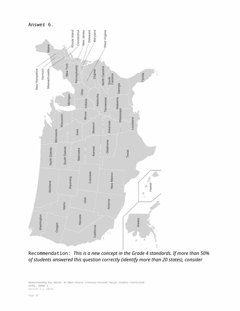
Question 6. Label as many states as you can on the picture below.
Understanding Our World: An Open-Source Literacy-Focused Social Studies CurriculumLEVEL: GRADE 4Version 2.1 (2018)
Page 17
Answer 6.
Recommendation: This is a new concept in the Grade 4 standards. If more than 50% of students answered this question correctly (identify more than 20 states), consider adding additional lessons on the state capitals or differences between the states to challenge students.
Understanding Our World: An Open-Source Literacy-Focused Social Studies CurriculumLEVEL: GRADE 4Version 2.1 (2018)
Page 18

Question 7. Explain where humans first began.
Answer 7. Humans began in Africa and then migrated or moved to the other parts of Earth.
Recommendation: This is a new concept in the Grade 4 standards. If more than 50% of students answered this question correctly, consider adding additional lessons on early man in Africa and migration.
Question 8. Name as many religions as you can.
Answer 8. Answers may vary, but could include Christianity/Christians (Catholicism, Protestantism, Quakers, etc.), Islam/Muslims, Judaism/Jews, Buddhism/Buddhists, Hinduism/Hindus, Shintoism, no religion/atheists.
Recommendation: This is a new concept in the Grade 4 standards. If more than 50% of students answered this question correctly (could identify at least 3 religions), consider adding additional lessons on world religions.
Question 9. What continent has the most people?
Answer 9. Asia
Recommendation: This is a new concept in the Grade 4 standards. If more than 50% of students answered this question correctly, consider adding additional lessons on world population.
Question 10. What countries border the United States?
Answer 10. Mexico and Canada
Recommendation: This is a new concept in the Grade 4 standards. If more than 50% of students answered this question correctly, consider adding additional lessons on the neighboring countries of the United States.
Understanding Our World: An Open-Source Literacy-Focused Social Studies CurriculumLEVEL: GRADE 4Version 2.1 (2018)
Page 19

LESSON PLAN 4-1: How Many Continents and Oceans Are There?
MATERIALS
Seven Continents Song Video (Lesson4-1Video1) [Located in the UOW Video Library: www.christophercmartell.com/understandingourworld]Five Oceans Song Video (Lesson4-1Video2) [Located in the UOW Video Library: www.christophercmartell.com/understandingourworld]Clipboards (not supplied)Continents and Oceans Notes (WORKSHEET 4-1.A)Source 1: 8 Continents Argument (SOURCEBOOK 4-1.B)Source 2: 7 Continents Argument (SOURCEBOOK 4-1.C)Source 3: 5 Continents Argument (SOURCEBOOK 4-1.D)Source 4: 3 Continents Argument (SOURCEBOOK 4-1.E)Source 5: 5 Oceans Argument (SOURCEBOOK 4-1.F)Source 6: 4 Oceans Argument (SOURCEBOOK 4-1.G)Source 7: 3 Oceans Argument (SOURCEBOOK 4-1.H)Source 8: 1 Ocean Argument (SOURCEBOOK 4-1.I)Continents and Oceans: Exit Ticket (ASSESSMENT 4-1.J)
STANDARDS
Massachusetts History and Social Science Framework
MA-HSS.4.CS.1: Use map and globe skills to determine absolute locations (latitude and longitude) of places studied. (G)
MA-HSS.4.8: On a map of the world, locate … Atlantic and Pacific Oceans.
MA-HSS.2.1: On a map of the world, locate all of the continents: North America, South America, Europe, Asia, Africa, Australia, and Antarctica. (G)
MA-HSS.2.3: Locate the oceans of the world: the Arctic, Atlantic, Indian, Pacific, and Southern Oceans. (G)
Common Core: Literacy
CCSS.ELA-Literacy.RI.4.9: Integrate information from two texts on the same topic in order to write or speak about the subject knowledgeably.
CCSS.ELA-Literacy.RI.4.10: By the end of year, read and comprehend informational texts, including history/social studies, science, and technical texts, in the grades 4–5 text complexity band proficiently, with scaffolding as needed at the high end of the range.
Understanding Our World: An Open-Source Literacy-Focused Social Studies CurriculumLEVEL: GRADE 4Version 2.1 (2018)
Page 20

CCSS.ELA-Literacy.W.4.8: Recall relevant information from experiences or gather relevant information from print and digital sources; take notes and categorize information, and provide a list of sources.
CCSS.ELA-Literacy.W.4.9: Draw evidence from literary or informational texts to support analysis, reflection, and research.
PROCEDURES
Inquiry Question: How many continents and oceans are there?
PREPARATION
1. Set Up Carousel ActivityAround the room, post the eight sources: 8 Continents Argument (SOURCEBOOK 4-1.B), 7 Continents Argument (SOURCEBOOK 4-1.C), 5 Continents Argument (SOURCEBOOK 4-1.D), 3 Continents Argument (SOURCEBOOK 4-1.E), 5 Oceans Argument (SOURCEBOOK 4-1.F), 4 Oceans Argument (SOURCEBOOK 4-1.G), 3 Oceans Argument (SOURCEBOOK 4-1.H), 1 Ocean Argument (SOURCEBOOK 4-1.I)
Sources 1-4 (Continents) should be posted on top of Sources 5-8 (Oceans), so that you can pull of the second set of sources to reveal them in the second part of the lesson.
2. Post Definitions of Continent and OceanPost the definitions of continent and ocean on the board or chart paper hidden from view. Continent: Large land masses separated from others by water. Ocean: A large body of water.
A. OPENER (10 minutes)
3. Watch the Seven Continents Song VideoShow the students a short video involving a nursery rhyme to remember the seven continents (Lesson4-1Video1). After watching the video, ask the students, “How many of you have learned that there are seven continents, like they say in this song?” Count how many students raise their hands. Then tell students that we don’t know how many continents there are, because it is debatable. Most people in English speaking countries say there are seven: North America, South America, Europe, Africa, Asia, Australia, and Antarctica, but that is debatable. In fact, the idea of continents was invented by humans. In some cultures, people say there are anywhere between 3 and 6, while geographers, people who study the Earth including how we map it, think there may be 3 and 9. We will debate this today.
4. Watch the Five Oceans Song Video
Understanding Our World: An Open-Source Literacy-Focused Social Studies CurriculumLEVEL: GRADE 4Version 2.1 (2018)
Page 21

Show the students a short video involving a nursery rhyme to remember the five oceans (Lesson4-1Video2). After watching the video, ask the students, “How many of you have learned that there are five oceans, like they say in this song?” Count how many students raise their hands. Then tell students that just like continents we do not know how many oceans there are, because it is debatable. Most people in English speaking countries say there are five: Atlantic, Pacific, Indian, Artic, Southern, but that is debatable. In fact, the idea of oceans was invented by humans. In some cultures, people say there are anywhere between 3 and 5, while scientists and some geographers, argue that there is only one connected ocean. We will debate this today.
B. DEVELOPMENT (20 minutes)
5. Engage in a Carousel Activity on the Number of Continents Give each student pencil and clipboard with the Continents and Oceans Notes (WORKSHEET 4-1.A) on it. Ask students to go to each of the four stations (4-1.B, 4-1.C, 4-1.D, 4-1.E). At each station, the students should take notes on the arguments about how many continents there are.
Once students have gone to each of the four stations, they should return to their seats. Put students in small groups. Have them look at their note sheets and debate which argument was most compelling or agreeable.
6. Engage in a Carousel Activity on the Number of OceansRemove all of the Continent Sources to reveal the Ocean Sources. Use tape or a magnet to put the Continent Sources up on the board or a section of the wall for future reference.
Students should continue to use their pencil and clipboard with the Continents and Oceans Notes (WORKSHEET 4-1.A) on it. Ask students to go to each of the four stations (4-1.F, 4-1.G, 4-1.H, 4-1.I). At each station, the students should take notes on the arguments about how many continents there are.
Once students have gone to each of the four stations, they should return to their seats. Students should again meet in small groups. Have them look at their note sheets and debate which argument was most compelling or agreeable.
C. CLOSING (15 minutes)
7. Write Up Argument on the Continents and Oceans For the evaluation task, have the students complete the exit ticket (ASSESSMENT 4-1.J), where they write their own personal response to the lesson’s Inquiry Question: “How many continents and oceans are there?” Tell students to cite at least three pieces of evidence from the sheets on the walls. Tell students that the evidence they use can be something that they wrote on the sheets. Encourage students to get up and look at the sheets on the wall, when they need evidence to write on their sheet.
Understanding Our World: An Open-Source Literacy-Focused Social Studies CurriculumLEVEL: GRADE 4Version 2.1 (2018)
Page 22

Before using the exit ticket, consider using a graphic organizer or two column notes to prepare students for the writing task. Consider using sentence starters and modeling to help the students with their answer to the inquiry question.
EVALUATION
ASSESSMENT 4-1.J
Before using the exit ticket, consider using a graphic organizer or two column notes to prepare students for the writing task (generic examples are available in the Organizers section at the end of this Instructor Manual-before “Writing Rubric”). Consider using sentence starters and modeling to help the students with their answer to the inquiry question.
A generic writing rubric for evaluating exit tickets is located at the end of this Instructor Manual-before “Additional Resources.”
What to look for?
The students should take a stance on the number of continents and oceans. All arguments should cite at least 3 pieces of evidence from the sources.
Some information that students may include in their answer to the question:
Continents: 8 Most scientific Uses the plate tectonics of the Earth Has the most continents
Continents: 7 Most widely used Most historical They had two houses, near the ocean (the first “beach side condo”) and the
woods They could house many families; this allowed families to be close Will be recognized by the most people around the world
Continents: 5 Closest to the dictionary definition Shows Eurasia and the Americas as single continent (clearly no oceans divide
them) Commonly used in many parts of Europe and South America.
Understanding Our World: An Open-Source Literacy-Focused Social Studies CurriculumLEVEL: GRADE 4Version 2.1 (2018)
Page 23

Continents: 3 Groups the major land masses and counts islands with the contents nearby Has the least continents
Oceans: 5 Has the most number of oceans Helpful for ocean navigation Used by many people today (although not most common) Includes the new Southern Ocean (2000)
Oceans: 4 Most widely used The Antarctic Ocean should not be counted, because it is really just the southern
part of the Atlantic, Pacific, and Indian Oceans.
Oceans: 3 Most historical Should not count Artic or Antarctic Oceans
Oceans: 1 Most scientific definition All of the oceans are connected Has the least number of oceans
Understanding Our World: An Open-Source Literacy-Focused Social Studies CurriculumLEVEL: GRADE 4Version 2.1 (2018)
Page 24

LESSON PLAN 4-2: Which Way Is Up? Seeing the World Through Different Maps
MATERIALS
Clipboards (not supplied)Making Maps Video (Lesson4-2Video1) [Located in the UOW Video Library: www.christophercmartell.com/understandingourworld]Various World Maps (MATERIALS 4-2.A) [This activity supplies standard handout-sized maps. This activity would work better if those maps were printed as large as possible or secure larger sized professionally produced maps using the same projections: Mercator Projection, Robinson Projection, Gall-Peters Projection, Atlantic-Centric, Pacific-Centric, Southern Hemisphere-Centric [South Up Map])Note Taking Sheet (WORKSHEET 4-2.B)Map Perspectives: Exit Ticket (ASSESSMENT 4-2.C)
STANDARDS
Massachusetts History and Social Science Framework
MA-HSS.4.CS.1: Use map and globe skills to determine absolute locations (latitude and longitude) of places studied. (G)
MA-HSS.4.8: On a map of the world, locate … Atlantic and Pacific Oceans.
MA-HSS.2.1: On a map of the world, locate all of the continents: North America, South America, Europe, Asia, Africa, Australia, and Antarctica. (G)
MA-HSS.2.3: Locate the oceans of the world: the Arctic, Atlantic, Indian, Pacific, and Southern Oceans. (G)
Common Core: Literacy
CCSS.ELA-Literacy.RI.4.9: Integrate information from two texts on the same topic in order to write or speak about the subject knowledgeably.
CCSS.ELA-Literacy.RI.4.10: By the end of year, read and comprehend informational texts, including history/social studies, science, and technical texts, in the grades 4–5 text complexity band proficiently, with scaffolding as needed at the high end of the range.
CCSS.ELA-Literacy.W.4.8: Recall relevant information from experiences or gather relevant information from print and digital sources; take notes and categorize information, and provide a list of sources.
CCSS.ELA-Literacy.W.4.9: Draw evidence from literary or informational texts to support analysis, reflection, and research.
Understanding Our World: An Open-Source Literacy-Focused Social Studies CurriculumLEVEL: GRADE 4Version 2.1 (2018)
Page 25
PROCEDURES
Inquiry Question: Which map is best?
PREPARATION
1. Set Up Carousel ActivityAround the room, post the six maps: Mercator Projection, Robinson Projection, Gall-Peters Projection, Atlantic-Centric, Pacific-Centric, Southern Hemisphere-Centric [South Up Map]) (MATERIALS 4-2.A) or professionally produced versions of the same maps. Be sure to post the map and correct description next to it.
A. OPENER (10 minutes)
2. Watch the Making Maps VideoShow the students a short video explaining the history and problems with map making (Lesson4-2Video1). During the video, stop it and highlight/ask questions about how it is difficult to make a globe flat, and the distortions that happen. Write the definition of distortion on the board or chart paper as “changing something so it is inaccurate or not completely true.” After watching the video, ask the students, did some of the maps the video showed us look weird or unusual to you? Why do you think that is? Anticipated student responses may include: we are used to looking at only one type of map, it is hard to make a globe flat, some maps make Africa and South America look smaller than they actually are.
B. DEVELOPMENT (20 minutes)
3. Examine the Maps Posted Around the RoomGive each student pencil and clipboard with the Note Taking Sheet (WORKSHEET 4-2.B) on it. Ask students to go to each of the six maps. At each map, the students should take notes on what they are seeing and feeling. There is a generic question listed to prompt them: What locations are at the center and top of this map? How does this look the same or different than maps you are using to looking at? Which maps do you think are more or less helpful (and for who)?
Once students have gone to each of the four stations, they should return to their seats. Put students in small groups. Have them look at their note sheets and debate which argument was most compelling or agreeable.
C. CLOSING (15 minutes)
4. Write Up Argument on the Continents and Oceans
Understanding Our World: An Open-Source Literacy-Focused Social Studies CurriculumLEVEL: GRADE 4Version 2.1 (2018)
Page 26

For the evaluation task, have the students complete the exit ticket (ASSESSMENT 4-2.C), where they write their own personal response to the lesson’s Inquiry Question: “Which map is best?” Tell students to cite at least three pieces of evidence from the maps and descriptions on the walls. Tell students that the evidence they use can be something that they wrote on their note taking sheets. Encourage students to get up and look at the maps and descriptions on the wall, when they need evidence to write on their sheet.
Before using the exit ticket, consider using a graphic organizer or two column notes to prepare students for the writing task. Consider using sentence starters and modeling to help the students with their answer to the inquiry question.
EVALUATION
ASSESSMENT 4-2.C
Before using the exit ticket, consider using a graphic organizer or two column notes to prepare students for the writing task (generic examples are available in the Organizers section at the end of this Instructor Manual-before “Writing Rubric”). Consider using sentence starters and modeling to help the students with their answer to the inquiry question.
A generic writing rubric for evaluating exit tickets is located at the end of this Instructor Manual-before “Additional Resources.”
What to look for?
The students should take a stance on the best map. All arguments should cite at least 3 pieces of evidence from the sources.
Some information that students may include in their answer to the question:
Mercator Projection It is the most helpful for navigation, because it will show you the most direct
angle from one point to the other. It is commonly used by Global Positioning Systems (GPS) maps, such as Google
Maps. It is the one that most Americans are used to using.
Robinson Projection It projects a globe on a rounded flat surface. It attempts to show the actual relative sizes of the land on earth comparing north
to south.
Understanding Our World: An Open-Source Literacy-Focused Social Studies CurriculumLEVEL: GRADE 4Version 2.1 (2018)
Page 27

Gall-Peters Projection It shows the correct ratios of land mass across the Earth. This means that it shows the exact size of one continent versus another. Shows the true size of each country in land size.
Atlantic-Centric and Physical Map It is most commonly used by people in the Americas, Europe, and Africa. It shows the areas where they often trade goods over the ocean. It can show you the elevation (how high or low) the land and water are, as well as
where you can find different terrain types.
Pacific-Centric and Political Map It is most commonly used by people in Asia. It shows the areas where they often trade goods over the ocean. It shows country’s boundaries, so you where they start and end.
Southern Hemisphere-Top This map makes you question what is up and what is down on a map. Since there is no true up or down in space, this map reminds us of that.
Understanding Our World: An Open-Source Literacy-Focused Social Studies CurriculumLEVEL: GRADE 4Version 2.1 (2018)
Page 28

LESSON PLAN 4-3: Africa: Where Humans Began
MATERIALS
The First Human Video (Lesson4-3Video1) [Located in the UOW Video Library: www.christophercmartell.com/understandingourworld]Source 1: Tools (SOURCEBOOK 4-3.A)Source 2: Fire! (SOURCEBOOK 4-3.B)Source 3: Y Chromosome Adam: Everyone’s Ancestor (SOURCEBOOK 4-3.C)Source 4: Agricultural (SOURCEBOOK 4-3.D)Africa: Where Man Began: Exit Ticket (ASSESSMENT 4-3.E)
STANDARDS
Massachusetts History and Social Science Framework
MA-HSS.4.CS.1: Use map and globe skills to determine absolute locations (latitude and longitude) of places studied. (G)
MA-HSS.7.1: Describe the great climatic and environmental changes that shaped the earth and eventually permitted the growth of human life. (H)
MA-HSS.7.4: Explain the importance of the invention of metallurgy and agriculture (the growing of crops and the domestication of animals). (H)
Common Core: Literacy
CCSS.ELA-Literacy.RI.4.9: Integrate information from two texts on the same topic in order to write or speak about the subject knowledgeably.
CCSS.ELA-Literacy.RI.4.10: By the end of year, read and comprehend informational texts, including history/social studies, science, and technical texts, in the grades 4–5 text complexity band proficiently, with scaffolding as needed at the high end of the range.
CCSS.ELA-Literacy.W.4.8: Recall relevant information from experiences or gather relevant information from print and digital sources; take notes and categorize information, and provide a list of sources.
CCSS.ELA-Literacy.W.4.9: Draw evidence from literary or informational texts to support analysis, reflection, and research.
PROCEDURES
Understanding Our World: An Open-Source Literacy-Focused Social Studies CurriculumLEVEL: GRADE 4Version 2.1 (2018)
Page 29

Inquiry Question: What was the most important event of early humans in Africa?
A. OPENER (10 minutes)
1. Watch First Human VideoShow the students a short video on the first human in Africa 160,000-70,000 years ago (Lesson4-3Video1). Ask the students if they were surprised to learn that all humans came from one person? Are you surprised to learn that all humans were originally from Africa? What did the video tell us help humans spread all over the world? Solicit students’ responses to these questions.
Tell students that today we are going to study the beginning of man in Africa.
B. DEVELOPMENT (20 minutes)
2. Read About the Different Events of Early Humans in AfricaPut students in small groups and assign them one of the sources: Tools (SOURCEBOOK 4-3.A), Fire! (SOURCEBOOK 4-3.B), Y Chromosome Adam: Everyone’s Ancestor (SOURCEBOOK 4-3.C), Agricultural (SOURCEBOOK 4-3.D). Have one student from each group read their source. As the student reads, tell the other group members to underline or highlight any important information.
3. Engage in a Jig Saw About Early Humans in AfricaHave students participate in a jig saw activity. Make new groups where at least one student from each of the original groups is included. This will create several new groups of three students, one is an expert on 4-3.A, 4-3.B, 4-3.C, 4-3.D. Have each student describe their document to the other members of their group.
Ask students to use the sources to answer the following inquiry question: “What was the most important event of early humans in Africa?” In answering this question, students should debate between the four different worksheets. After students have discussed the question, they should complete the exit ticket in the following step. Circulate the room, helping the students who may have difficulty choosing one asset.
C. CLOSING (15 minutes)
4. Write Up Argument on the Early Humans in AfricaFor the evaluation task, have the students complete the exit ticket (ASSESSMENT 4-3.E), where they write their own personal response to the lesson’s Inquiry Question: “What was the most important event of early humans in Africa?” Tell students to cite at least three pieces of evidence from the sources for this lesson.
Before using the exit ticket, consider using a graphic organizer or two column notes to prepare students for the writing task. Consider using sentence starters and modeling to help the students with their answer to the inquiry question.
Understanding Our World: An Open-Source Literacy-Focused Social Studies CurriculumLEVEL: GRADE 4Version 2.1 (2018)
Page 30

EVALUATION
ASSESSMENT 4-3.D
Before using the exit ticket, consider using a graphic organizer or two column notes to prepare students for the writing task (generic examples are available in the Organizers section at the end of this Instructor Manual-before “Writing Rubric”). Consider using sentence starters and modeling to help the students with their answer to the inquiry question.
A generic writing rubric for evaluating exit tickets is located at the end of this Instructor Manual-before “Additional Resources.”
What to look for?
The students should take a stance on the most important event of early humans. All arguments should cite at least 3 pieces of evidence from the sources.
Some information that students may include in their answer to the question:
Tools By eating meat from animals, the first humans were able to grow stronger due to
the proteins and nutrients in meat. Unlike many plants, most meat does not include toxins (so it was a safer food),
but it does spoil faster than plants. Meat is also more quickly digested, so the body can save energy for the brain
and other organs. Hunting mean can also be dangerous and many humans were killed during
hunts.
Fire! Fire gave humans warmth during the cold. It helped protect them from other animals. It helped them stay awake for longer amounts of time. It helped them cook their food (which meant food would be safer to eat, as heat
killed deadly parasites). Fire allowed humans to settle in one place. This had a positive impact on families
(moving around all the time could be difficult) and helped create languages (spending time in one place allowed time for humans to speak to one and other).
Fire may have also lead to the first human art works, as many were cave drawings done with soot from a fire.
Y Chromosome Adam: Everyone’s Ancestor All humans are descendant from a male in Africa (Y Chromosome Adam) Humans migrated within and outside Africa. This migration made humans a
diverse species.
Understanding Our World: An Open-Source Literacy-Focused Social Studies CurriculumLEVEL: GRADE 4Version 2.1 (2018)
Page 31
Over time, the environment influenced skin color and eye shape.
Agricultural About 23,000-12,000 years ago, man began to farm (agriculture). Before humans farmed, people needed to travel to follow the animals and plants
that were their food; humans could now settle in one place and form communities.
Humans started to grow plants and animals around the same time. They also used those animals for work.
Farming also allowed humans to move into colder climates. It allowed them to grow food and store it for winter. Also, having more stable food allowed humans to better survive, as they were not always having periods of starvation.
Understanding Our World: An Open-Source Literacy-Focused Social Studies CurriculumLEVEL: GRADE 4Version 2.1 (2018)
Page 32

LESSON PLAN 4-4: Ancient Egypt
MATERIALS
Wooden blocks (100 block set is recommended; not supplied)Blank drawing paper (not supplied)Ancient Egypt Social Class Cards (SOURCEBOOK 4-4.A)Ancient Egypt: Exit Ticket (ASSESSMENT 4-4.B)
STANDARDS
Massachusetts History and Social Science Framework
MA-HSS.4.CS.1: Use map and globe skills to determine absolute locations (latitude and longitude) of places studied. (G)
MA-HSS.7.13: Describe the kinds of evidence that have been used by archaeologists and historians to draw conclusions about the social and economic characteristics of Ancient Nubia (the Kingdom of Kush) and their relationship to the social and economic characteristics of Ancient Egypt. (H, G)
Common Core: Literacy
CCSS.ELA-Literacy.RI.4.9: Integrate information from two texts on the same topic in order to write or speak about the subject knowledgeably.
CCSS.ELA-Literacy.RI.4.10: By the end of year, read and comprehend informational texts, including history/social studies, science, and technical texts, in the grades 4–5 text complexity band proficiently, with scaffolding as needed at the high end of the range.
CCSS.ELA-Literacy.W.4.4: Recall relevant information from experiences or gather relevant information from print and digital sources; take notes and categorize information, and provide a list of sources.
CCSS.ELA-Literacy.W.4.5: Draw evidence from literary or informational texts to support analysis, reflection, and research.
PROCEDURES
Inquiry Question: If you could be in any ancient Egyptian social class, which would you choose and why?
PREPARATION
Understanding Our World: An Open-Source Literacy-Focused Social Studies CurriculumLEVEL: GRADE 4Version 2.1 (2018)
Page 33

1. Review the Roles listed on the Ancient Egypt Social Class CardCarefully review and familiarize yourself with the 5 different roles on the Ancient Egypt Social Class Cards (SOURCEBOOK 4-4.A) for this lesson.
While the students should receive all of the cards in a packet, you should circle or highlight the card that they have individually been assigned to. The largest number of students should be peasants and workers, with smaller numbers being priests and soldiers, and only one person should be the pharaoh. The gender of the card does not need to be the same as the gender of the student.
A. OPENER (20 minutes)
2. Participate in an Ancient Egypt Social Class SimulationTell students that today we are going to pretend we are in Ancient Egypt, which was an Empire in Africa. Each student will represent a specific person who existed in Ancient Egypt: Pharaoh, Priests, Soldiers, Workers, Peasants. Give the students the worksheet titled (with all of the social classes) Ancient Egypt Social Class Cards (WORKSHEET 4-4.A) that describes each social class and their directions. There are five different social class listed on the cards.
Some of the activities students may be asked to do: Priests: Pray quietly in a circle. Choose where to build and grow crops. Soldiers: Go to war (walk back and forth from two walls of the pharaoh’s
choosing). Workers: Build pyramid and other building structures. Peasants: Grow crops (drawing pictures of wheat).
Tell the students to each read their social class card. Do this one by one until all the students have heard the rules for the five social classes. Next, have them look at their card and underline or highlight their social class and the details of their day-to-day life.
Tell students that they are now in Ancient Egypt and they will need to follow the rules listed under the directions for their social class card.
Have students take part in the social class simulation. They should interact with each other using the directions on their cards.
After the simulation is over, write the names of the five social classes on the board or chart paper. Have students in each social class list what their life was like and take notes about these under each category. After, ask students which people they thought were at the top or had the most power. Ask students which people were at the bottom or had least power (The current order shows most powerful to least powerful: Pharaoh, Priests, Soldiers, Workers, Peasants).
B. DEVELOPMENT (15 minutes)
Understanding Our World: An Open-Source Literacy-Focused Social Studies CurriculumLEVEL: GRADE 4Version 2.1 (2018)
Page 34

3. Write Up Argument on the Ancient Egypt Social ClassFor the evaluation task, have the students complete the exit ticket (ASSESSMENT 4-4.B), where they write their own personal response to the lesson’s Inquiry Question: “If you could be in any ancient Egyptian social class, which would you choose and why?” Tell students to cite at least three pieces of evidence from the Ancient Egypt Social Class Cards.
Before using the exit ticket, consider using a graphic organizer or two column notes to prepare students for the writing task. Consider using sentence starters and modeling to help the students with their answer to the inquiry question.
C. CLOSING (10 minutes)
4. Share ArgumentsHave students share their arguments about social class with the class. Draw comparisons between the different students’ stories and list them on the board or chart paper.
EVALUATION
ASSESSMENT 4-4.B
Before using the exit ticket, consider using a graphic organizer or two column notes to prepare students for the writing task (generic examples are available in the Organizers section at the end of this Instructor Manual-before “Writing Rubric”). Consider using sentence starters and modeling to help the students with their answer to the inquiry question.
A generic writing rubric for evaluating exit tickets is located at the end of this Instructor Manual-before “Additional Resources.”
What to look for?
The students should take a stance on the ancient Egyptian social class that they would want to be a part of. All arguments should cite at least 3 pieces of evidence from the sources.
Some information that students may include in their answer to the question:
Pharaoh (not allowed to write about)
Priests They made many choices, where to build buildings or grow food Had a lot of power; right under the pharaoh
Understanding Our World: An Open-Source Literacy-Focused Social Studies CurriculumLEVEL: GRADE 4Version 2.1 (2018)
Page 35

Negative: Did not have much freedom over what to eat or wear
Soldiers Were respected by many people Had more power than workers or peasants Negative: Died in war; had to march far distances
Workers Did an important and skilled job building things for the empire Had more power than peasants Did not have to fight in wars Could eat and wear whatever they wanted Negative: Dies in accidents
Peasants Did an important job of growing everyone’s food Did not have to fight in wars Could eat and wear whatever they wanted Negative: Least power
Understanding Our World: An Open-Source Literacy-Focused Social Studies CurriculumLEVEL: GRADE 4Version 2.1 (2018)
Page 36

LESSON PLAN 4-5: The Great African Empires: Ghana, Kongo, Ethiopia, and Zimbabwe
MATERIALS
History of Metal (Lesson4-5Video1) [Located in the UOW Video Library: www.christophercmartell.com/understandingourworld]Clipboard (not supplied)Source 1: Ghana (SOURCEBOOK 4-5.A)Source 2: Kongo (SOURCEBOOK 4-5.B)Source 3: Ethiopia (SOURCEBOOK 4-5.C)Source 4: Zimbabwe (SOURCEBOOK 4-5.D)Note Taking Sheet (WORKSHEET 4-5.E)The Great African Empires: Exit Ticket (ASSESSMENT 4-5.F)
STANDARDS
Massachusetts History and Social Science Framework
MA-HSS.4.CS.1: Use map and globe skills to determine absolute locations (latitude and longitude) of places studied. (G)
MA-HSS.WHI.19: Describe important political and economic aspects of the African empires. (H, E)
Common Core: Literacy
CCSS.ELA-Literacy.RI.4.9: Integrate information from two texts on the same topic in order to write or speak about the subject knowledgeably.
CCSS.ELA-Literacy.RI.4.10: By the end of year, read and comprehend informational texts, including history/social studies, science, and technical texts, in the grades 4–5 text complexity band proficiently, with scaffolding as needed at the high end of the range.
CCSS.ELA-Literacy.W.4.8: Recall relevant information from experiences or gather relevant information from print and digital sources; take notes and categorize information, and provide a list of sources.
CCSS.ELA-Literacy.W.4.9: Draw evidence from literary or informational texts to support analysis, reflection, and research.
Understanding Our World: An Open-Source Literacy-Focused Social Studies CurriculumLEVEL: GRADE 4Version 2.1 (2018)
Page 37

PROCEDURES
Inquiry Question: If you could live in any African empire, which one would it be and why?
PREPARATION
1. Set Up Carousel ActivityAround the room, post the four sources: Ghana (SOURCEBOOK 4-5.A), Kongo (SOURCEBOOK 4-5.B), Ethiopia (SOURCEBOOK 4-5.C), Zimbabwe (SOURCEBOOK 4-5.D).
A. OPENER (10 minutes)
2. Watch the History of Metal VideoShow the students a short video describing the invention of metal in Africa (Lesson4-5Video1). After watching the video, ask the students to tell you all the things they can think of that are made of metal. List the items on the board or chart paper. Ask students, why do they think that being able to make metal is important and what would life be like today without metals.
Tell the students that today we are going to study four of the Great African Empires, which were groups of people who were grouped together to form large nations that protected each other and had a single ruler (much like the pharaoh of Ancient Egypt). These empires were able to happen, in part, because of metal. Many of these empires became powerful by trading metals to people in Europe and Asia.
B. DEVELOPMENT (20 minutes)
3. Engage in a Carousel Activity on the Number of Continents Give each student pencil and clipboard with the Note Taking Sheet (WORKSHEET 4-5.E) on it. Ask students to go to each of the four stations (4-5.A, 4-5.B, 4-5.C, 4-5.D). At each station, the students should take notes on the different Great African Empires.
Once students have gone to each of the four stations, they should return to their seats. Put students in small groups. Have them look at their note sheets and debate which empire they think would be the place where they would want to live.
C. CLOSING (15 minutes)
4. Write Up Argument on the Great African Empires
Understanding Our World: An Open-Source Literacy-Focused Social Studies CurriculumLEVEL: GRADE 4Version 2.1 (2018)
Page 38

For the evaluation task, have the students complete the exit ticket (ASSESSMENT 4-5.F), where they write their own personal response to the lesson’s Inquiry Question: “If you could live in any African empire, which one would it be and why?” Tell students to cite at least three pieces of evidence from the sheets on the walls. Tell students that the evidence they use can be something that they wrote on the sheets. Encourage students to get up and look at the sheets on the wall, when they need evidence to write on their sheet.
Before using the exit ticket, consider using a graphic organizer or two column notes to prepare students for the writing task. Consider using sentence starters and modeling to help the students with their answer to the inquiry question.
EVALUATION
ASSESSMENT 4-5.F
Before using the exit ticket, consider using a graphic organizer or two column notes to prepare students for the writing task (generic examples are available in the Organizers section at the end of this Instructor Manual-before “Writing Rubric”). Consider using sentence starters and modeling to help the students with their answer to the inquiry question.
A generic writing rubric for evaluating exit tickets is located at the end of this Instructor Manual-before “Additional Resources.”
What to look for?
The students should take a stance on what African empire they would live in. All arguments should cite at least 3 pieces of evidence from the sources.
Some information that students may include in their answer to the question:
Ghana My ancestors came from there Located in West Africa Desert climate with hot and dry year-round with some rain in the winter Medium empire (30,000 people) Became very rich from mining and trading iron and gold Use camels to bring it to other empires across the Sahara Desert People lived in large houses with extended family Muslims were the largest religious group
Kongo My ancestors came from there Located in Central Africa Tropical climate with hot and dry summers, and warm and rainy winters
Understanding Our World: An Open-Source Literacy-Focused Social Studies CurriculumLEVEL: GRADE 4Version 2.1 (2018)
Page 39
Very large empire (500,000 people) Empire became very rich from mining and trading iron and copper They would sell much of their metals to Europe through ports on the Atlantic People lived in small houses with immediate family, but were close to other
relatives A native religion was the largest religious group
Ethiopia My ancestors came from there Located in East Africa Tropical climate with hot and rainy summers, and warm and dry winters Small empire (20,000) Became very rich from mining and trading iron, gold, and salt (more than just
metals) They would sell much of their metals to Europe and the Middle East, as they
were near the Silk Road (best trade location) People lived in small houses with immediate family Christianity was the largest religious group
Zimbabwe My ancestors came from there Located in Southern Africa Subtropical climate with warm and rainy winters and dry and hot summers Small empire (18,000) The Zimbabwe Empire became very rich from mining and trading copper, iron,
and gold Build large granite structures People lived in small houses with immediate family Shona was the largest religious group
Understanding Our World: An Open-Source Literacy-Focused Social Studies CurriculumLEVEL: GRADE 4Version 2.1 (2018)
Page 40

LESSON PLAN 4-6: Timbuktu: How Trade Shaped a City
MATERIALS
Images (SOURCEBOOK 4-6.A)Source 1: Trade (SOURCEBOOK 4-6.B)Source 2: Education (SOURCEBOOK 4-6.C)Source 3: Religion (SOURCEBOOK 4-6.D)Timbuktu: Exit Ticket (ASSESSMENT 4-6.E)
STANDARDS
Massachusetts History and Social Science Framework
MA-HSS.4.CS.1: Use map and globe skills to determine absolute locations (latitude and longitude) of places studied. (G)
MA-HSS.WHI.19: Describe important political and economic aspects of the African empires. (H, E)
Common Core: Literacy
CCSS.ELA-Literacy.RI.4.9: Integrate information from two texts on the same topic in order to write or speak about the subject knowledgeably.
CCSS.ELA-Literacy.RI.4.10: By the end of year, read and comprehend informational texts, including history/social studies, science, and technical texts, in the grades 4–5 text complexity band proficiently, with scaffolding as needed at the high end of the range.
CCSS.ELA-Literacy.W.4.8: Recall relevant information from experiences or gather relevant information from print and digital sources; take notes and categorize information, and provide a list of sources.
CCSS.ELA-Literacy.W.4.9: Draw evidence from literary or informational texts to support analysis, reflection, and research.
PROCEDURES
Inquiry Question: Why was Timbuktu so important?
PREPARATION
Understanding Our World: An Open-Source Literacy-Focused Social Studies CurriculumLEVEL: GRADE 4Version 2.1 (2018)
Page 41

This lesson uses a method called Visual Thinking Strategy (VTS). The key to VTS is that you as a teacher only do two things: (1) Ask the following questions and (2) repeat as precisely as possible exactly what the students say.
Visual Thinking Strategy Questions: Open with: “What’s going on in this picture?”
Summarize student responses using conditional language (“Raoul thinks this could be…”). This keeps the conversation open to other interpretations by other students.
If appropriate: “What do you see that makes you say that?”This encourages students to back up their statements with things they see in the work of art.
Ask the group: “What more can we find?”This continues the conversation.
If this is your first time using VTS, I would recommend reading this description (with a video example from Grade 1) of it from the Milwaukee Art Museum: http://teachers.mam.org/collection/teaching-with-art/visual-thinking-strategies-vts/
A. OPENER (10 minutes)
1. Engage in a Visual Thinking Strategy (VTS) on Timbuktu ImagesGive students Images (SOURCEBOOK 4-6.A). Do not reveal that these are images of Timbuktu or Africa. Project the first image (Lettered “A”) and tell the students to look at the image closely and quietly. Give them about one minute. Next, begin the VTS question about the image. Use the above questions, following VTS instructions. Have students inquire about the question using the above questions for about 2-3 minutes.
Project the second image (Lettered “B”) and tell the students to look at the image closely and quietly. Give them about one minute. Next, begin the VTS question about the image. Use the above questions, following VTS instructions. Have students inquire about the question using the above questions for about 2-3 minutes.
Tell students that today we will be learning about the city of Timbuktu in Africa. It was the heart of trade with many goods being transported through it. Picture A was a picture from today of the Mosque in the center if the city and Picture B was what the city looked like hundreds of years ago. You had many good observations of the pictures. From the pictures, what do you think life was and is like in Timbuktu? Anticipated responses may include: it is in a desert, it was very large, some people there are Muslim (Mosque), it was very important. Tell the students that we will learn today about the many different parts of Timbuktu and it will have to decide what was most important. B. DEVELOPMENT (20 minutes)
2. Read About the Different Parts of Timbuktu
Understanding Our World: An Open-Source Literacy-Focused Social Studies CurriculumLEVEL: GRADE 4Version 2.1 (2018)
Page 42

Put students in small groups and assign them one of the sources: Trade (SOURCEBOOK 4-6.B), Education (SOURCEBOOK 4-6.C), Religion (SOURCEBOOK 4-6.D). Have one student from each group read their source. As the student reads, tell the other group members to underline or highlight any important information.
3. Engage in a Jig Saw About TimbuktuHave students participate in a jig saw activity. Make new groups where at least one student from each of the original groups is included. This will create several new groups of three students, one is an expert on 4-6.B, 4-6.C, 4-6.D. Have each student describe their document to the other members of their group.
Ask students to use the sources to answer the following inquiry question: “Why was Timbuktu so important?” In answering this question, students should debate between the four different worksheets. After students have discussed the question, they should complete the exit ticket in the following step. Circulate the room, helping the students who may have difficulty choosing one asset.
C. CLOSING (15 minutes)
4. Write Up Argument on the Most Important Part of TimbuktuFor the evaluation task, have the students complete the exit ticket (ASSESSMENT 4-6.E), where they write their own personal response to the lesson’s Inquiry Question: “Why was Timbuktu so important?” and choose the part they think was most important. Tell students to cite at least three pieces of evidence from the sources for this lesson.
Before using the exit ticket, consider using a graphic organizer or two column notes to prepare students for the writing task. Consider using sentence starters and modeling to help the students with their answer to the inquiry question.
EVALUATION
ASSESSMENT 4-6.E
Before using the exit ticket, consider using a graphic organizer or two column notes to prepare students for the writing task (generic examples are available in the Organizers section at the end of this Instructor Manual-before “Writing Rubric”). Consider using sentence starters and modeling to help the students with their answer to the inquiry question.
A generic writing rubric for evaluating exit tickets is located at the end of this Instructor Manual-before “Additional Resources.”What to look for?
The students should take a stance on why Timbuktu was so important. All arguments should cite at least 3 pieces of evidence from the sources.
Understanding Our World: An Open-Source Literacy-Focused Social Studies CurriculumLEVEL: GRADE 4Version 2.1 (2018)
Page 43

Some information that students may include in their answer to the question:
Trade It was a center of trade in Africa, selling sugar, nuts, salt, cloth, books, and glass. It became one of the wealthiest cities in the world. It had goods from all over the world.
Education Important place for schools and learning. Libraries had over 700,000 books, about art, medicine, philosophy, science, and
religion. Many people would travel there from all over Africa and the world to learn.
Religion A large mosque or Muslim place of worship was built there by Mansa Musa I. People would travel all over the world to learn about religion (Islam) there. They would copy religious books there.
Understanding Our World: An Open-Source Literacy-Focused Social Studies CurriculumLEVEL: GRADE 4Version 2.1 (2018)
Page 44

LESSON PLAN 4-7: Apartheid in South Africa: A Movement for Freedom
MATERIALS
“Nelson Mandela” by Kadir Nelson (not supplied)Source 1: European Imperialism (SOURCEBOOK 4-7.A)Source 2: Apartheid Laws (SOURCEBOOK 4-7.B)Source 3: Anti-Apartheid Protests (SOURCEBOOK 4-7.C)Source 4: Jailed Protesters (SOURCEBOOK 4-7.D)Anti-Apartheid: Exit Ticket (ASSESSMENT 4-7.E)
STANDARDS
Massachusetts History and Social Science Framework
MA-HSS.4.CS.1: Use map and globe skills to determine absolute locations (latitude and longitude) of places studied. (G)
MA-HSS.WHII.44 Explain the reasons for the fall of apartheid in South Africa, including the influence and ideas of Nelson Mandela. (H)
Common Core: Literacy
CCSS.ELA-Literacy.RI.4.9: Integrate information from two texts on the same topic in order to write or speak about the subject knowledgeably.
CCSS.ELA-Literacy.RI.4.10: By the end of year, read and comprehend informational texts, including history/social studies, science, and technical texts, in the grades 4–5 text complexity band proficiently, with scaffolding as needed at the high end of the range.
CCSS.ELA-Literacy.W.4.8: Recall relevant information from experiences or gather relevant information from print and digital sources; take notes and categorize information, and provide a list of sources.
CCSS.ELA-Literacy.W.4.9: Draw evidence from literary or informational texts to support analysis, reflection, and research.
PROCEDURES
Inquiry Question: What can we learn from the Anti-Apartheid Movement in South Africa?
PREPARATION
Understanding Our World: An Open-Source Literacy-Focused Social Studies CurriculumLEVEL: GRADE 4Version 2.1 (2018)
Page 45

1. Post Definition of Discrimination
Post the definitions of migration on the board or chart paper hidden from view. Discrimination: Unfair treatment, especially because of a person’s race, gender, religion, or age.
A. OPENER (15 minutes)
2. Read “Nelson Mandela” by Kadir NelsonBefore reading the text, tell students that today we are going to read a story about a man who spoke out against discrimination in South Africa. Ask students if they know what discrimination means. Reveal the definition of discrimination as “Unfair treatment, especially because of a person’s race, gender, religion, or age.” Ask students if they can think of any examples from the past or today when people were discriminated against? Anticipated responses may include: laws against African Americans before the civil rights movement, Martin Luther King, personal or family examples.
Read “Nelson Mandela.” This is a picture book that tells the true story of a Nelson Mandela who was a leader to the Anti-Apartheid movement in South Africa. As you read the text, be sure to ask questions to the students about Mandela’s experiences and choices. Connect this story to the work the students have done in previous grades related to slavery, segregation, and civil rights.
Tell students that today, we are going to learn about the Apartheid laws that existed in South Africa and what people did there to try and stop it.
B. DEVELOPMENT (15 minutes)
3. Examine Sources As a Whole ClassAsk the students to read aloud (using choral, partner, or independent reading) the three documents on Apartheid Laws (SOURCEBOOK 4-7.A), Anti-Apartheid Protests (SOURCEBOOK 4-7.B), Jailed Protesters (SOURCEBOOK 4-7.C), Help from Other Countries (SOURCEBOOK 4-7.D). After reading each document, solicit from students what important facts should be underlined and highlighted about each source. Make sure they highlight examples of how the Apartheid was problematic (i.e. segregation laws), but also acts of resistance to it (i.e. being jailed for protesting, boycotts).
4. Discuss the Struggles that Black and Asian People Faced in South AfricaPut students in small groups (3-4 students). Tell students that after listening to “Nelson Mandela” and reading these sources, I would like you to talk about ways that life was difficult for Black and Asian people in South Africa under Apartheid, but also ways that people did things to stop Apartheid because it was wrong.
After students have had 5-7 minutes to discuss, lead the class in a whole class discussion. On the board or chart paper, take notes on what the students say.
Understanding Our World: An Open-Source Literacy-Focused Social Studies CurriculumLEVEL: GRADE 4Version 2.1 (2018)
Page 46

Anticipated responses may include: protesting, going to jail for their beliefs, boycotting rules, spreading the word around the world.
C. CLOSING (15 minutes)
5. Answer the Inquiry QuestionFor the evaluation task, have the students complete the exit ticket (ASSESSMENT 4-7.E), where they write their own personal response to the lesson’s Inquiry Question: “What can we learn from the Anti-Apartheid Movement in South Africa?” Tell students to cite at least three pieces of evidence from the book (Nelson Mandela) and the sources for this lesson.
Before using the exit ticket, consider using a graphic organizer or two column notes to prepare students for the writing task. Consider using sentence starters and modeling to help the students with their answer to the inquiry question.
EVALUATION
ASSESSMENT 4-7.E
Before using the exit ticket, consider using a graphic organizer or two column notes to prepare students for the writing task (generic examples are available in the Organizers section at the end of this Instructor Manual-before “Writing Rubric”). Consider using sentence starters and modeling to help the students with their answer to the inquiry question.
A generic writing rubric for evaluating exit tickets is located at the end of this Instructor Manual-before “Additional Resources.”
What to look for?
The students should take a stance on what we can learn from the Anti-Apartheid Movement. All arguments should cite at least 3 pieces of evidence from the sources.
Some information that students may include in their answer to the question:
Ways that protesters worked to end Apartheid: Protesting. Going to jail for their beliefs. Boycotting rules. Spreading the word around the world.
Understanding Our World: An Open-Source Literacy-Focused Social Studies CurriculumLEVEL: GRADE 4Version 2.1 (2018)
Page 47

LESSON PLAN 4-8: Africa Today: Diverse Nations, Diverse People
MATERIALS
Carmen Sandiego Introduction Video (Lesson4-8Video1) [Located in the UOW Video Library: www.christophercmartell.com/understandingourworld]Drawing paper (not supplied)Markers (not supplied)Lined paper (not supplied)Clipboards (not supplied)Carmen Sandiego Questions and Crime Bucks (MATERIALS 4-8.A)Source 1: Egypt (SOURCEBOOK 4-8.B)Source 2: Morocco (SOURCEBOOK 4-8.C)Source 3: Nigeria (SOURCEBOOK 4-8.D)Source 4: Zimbabwe (SOURCEBOOK 4-8.E)Source 5: Kenya (SOURCEBOOK 4-8.F)Source 6: South Africa (SOURCEBOOK 4-8.G)Source 7: Cape Verde (SOURCEBOOK 4-8.H)Source 8: Madagascar (SOURCEBOOK 4-8.I)Africa Today: Exit Ticket (ASSESSMENT 4-8.J)
STANDARDS
Massachusetts History and Social Science Framework
MA-HSS.4.CS.1: Use map and globe skills to determine absolute locations (latitude and longitude) of places studied. (G)
MA-HSS.6.A.2: Use a map key to locate countries and major cities in Africa. (G, E)
Common Core: Literacy
CCSS.ELA-Literacy.RI.4.9: Integrate information from two texts on the same topic in order to write or speak about the subject knowledgeably.
CCSS.ELA-Literacy.RI.4.10: By the end of year, read and comprehend informational texts, including history/social studies, science, and technical texts, in the grades 4–5 text complexity band proficiently, with scaffolding as needed at the high end of the range.
CCSS.ELA-Literacy.W.4.8: Recall relevant information from experiences or gather relevant information from print and digital sources; take notes and categorize information, and provide a list of sources.
CCSS.ELA-Literacy.W.4.9: Draw evidence from literary or informational texts to support analysis, reflection, and research.
Understanding Our World: An Open-Source Literacy-Focused Social Studies CurriculumLEVEL: GRADE 4Version 2.1 (2018)
Page 48

PROCEDURES
Inquiry Question: If you were to visit Africa today, what country would you choose and why?
PREPARATION
1. Cut Out Carmen Sandiego BucksMake 15 copies of the Crime Bucks (MATERIALS 4-8.A) sheet and cut them out.
2. Set Up Carousel ActivityAround the room, post the eight sources: Egypt (SOURCEBOOK 4-8.B), Morocco (SOURCEBOOK 4-8.C), Nigeria (SOURCEBOOK 4-8.D), Zimbabwe (SOURCEBOOK 4-8.E), Kenya (SOURCEBOOK 4-8.F), South Africa (SOURCEBOOK 4-8.G), Cape Verde (SOURCEBOOK 4-8.H), Madagascar (SOURCEBOOK 4-8.I)
A. OPENER (15 minutes)
3. Play the “Where in the World Is Carmen Sandiego” GameDivide the class into three groups: Team Izzat, Team Ajay, and Team Jamal (the contestants in the video that they are about to watch).
Show the students a short video that is the opening to the PBS show “Where in the World Is Carmen Sandiego” (Lesson4-8Video1). After watching the video, tell the students that today we are going to start class by being contestants on “Where in the World Is Carmen Sandiego” and the episode “Diamonds Are a Crook’s Best Friend.” As you saw in the video, The Contessa has stolen diamonds from South Africa. Tell the students that they will each start with $50 Carmen Sandiego Bucks. For each question about Africa that they get right, they will earn $10 Carmen Sandiego Bucks. At the end of the game, the team with the most Carmen Sandiego Bucks catches The Contessa and her diamonds and wins the game. Are you ready to play gumshoes?
You will then read the questions about Africa found on the Carmen Sandiego Questions (MATERIALS 4-8.A). Each group will talk among themselves and write their answer to the question using a marker on a sheet of drawing paper. After each team holds up their answer, give students $10 Carmen Sandiego Bucks if they get it correct. Tabulate the total for each team (starting with all teams getting $50). At the end of the game count up the totals and declare a team(s) the winner. Tell the students that they successful caught The Contessa.
Tell the students that their next challenge is to find Carmen Sandiego. She is hiding somewhere in Africa. You will get a chance to look at eight different African countries and what life is like there today. You will choose which country you would most like to visit. At the end of the lesson, I will reveal where Carmen Sandiego is hiding and we can see if she decided to go to the same country as you.
Understanding Our World: An Open-Source Literacy-Focused Social Studies CurriculumLEVEL: GRADE 4Version 2.1 (2018)
Page 49

B. DEVELOPMENT (15 minutes)
4. Engage in a Carousel Activity on African Countries Handout lined paper and clipboards. Ask students to go to each of the eight stations (4-8.B, 4-8.C, 4-8.D, 4-8.E, 4-8.F, 4-8.G, 4-8.H, 4-8.I). At each station, the students should write the country’s name and take notes on each.
Once students have gone to each of the eight stations, they should return to their seats. Put students in small groups. Have them look at their notes and discuss with their classmates which country they would like to travel to.
C. CLOSING (15 minutes)
5. Write Up Argument on African Countries For the evaluation task, have the students complete the exit ticket (ASSESSMENT 4-8.J), where they write their own personal response to the lesson’s Inquiry Question: “If you were to visit Africa today, what country would you choose and why?” Tell students to cite at least three pieces of evidence from the sheets on the walls. Tell students that the evidence they use can be something that they wrote on their notes. Encourage students to get up and look at the sheets on the wall, when they need evidence to write on their sheet.
Before using the exit ticket, consider using a graphic organizer or two column notes to prepare students for the writing task. Consider using sentence starters and modeling to help the students with their answer to the inquiry question.
6. Reveal the Location of Carmen SandiegoAt the end of the lesson, reveal that Carmen Sandiego is hiding in South Africa. Just like The Contessa, she also wanted to steal the jewels. Have students give a round of applause for the students who chose the same country as Carmen Sandiego.
EVALUATION
ASSESSMENT 4-8.J
Before using the exit ticket, consider using a graphic organizer or two column notes to prepare students for the writing task (generic examples are available in the Organizers section at the end of this Instructor Manual-before “Writing Rubric”). Consider using
Understanding Our World: An Open-Source Literacy-Focused Social Studies CurriculumLEVEL: GRADE 4Version 2.1 (2018)
Page 50
sentence starters and modeling to help the students with their answer to the inquiry question.
A generic writing rubric for evaluating exit tickets is located at the end of this Instructor Manual-before “Additional Resources.”
What to look for?
The students should take a stance on what country in Africa would they like to visit. All arguments should cite at least 3 pieces of evidence from the sources.
Some information that students may include in their answer to the question:
Egypt Visiting the famous pyramids and the Sphinx. Seeing the Nile River. Visiting Cairo. It is a large country (89 million people). Visiting a country run by the military. Being in a place where they speak Arabic. Visiting a place where Muslims and Christians live. Visiting a desert. Like the climate/weather (hot and dry in the summer and cool and humid with
occasional rain in the winter).
Morocco Visiting amazing markets (Fes). Visiting a place where Arab, Berber, and French culture comes together. Visiting a country with a king. Visiting a medium sized country (32 million people). Being in a place where they speak Arabic, Berber, and French. Visiting a place where Muslims live. Visiting a desert. Like the climate/weather (hot and dry in the summer and cool and humid with
occasional rain in the winter).
Nigeria Visiting large cities. Visiting Lagos (the New York City of Africa). Visiting a country with over 500 ethnic groups and languages. Visit a country with an elected president. Visit a large country (167 million people). Visit a place where Muslims, Christians, and people with indigenous faiths live.
Like the tropical climate/weather (cool and dry in the summer and warm and rainy in the winter).
Zimbabwe
Understanding Our World: An Open-Source Literacy-Focused Social Studies CurriculumLEVEL: GRADE 4Version 2.1 (2018)
Page 51

See the nature and/or Victoria Falls. Visit a place with 16 different languages (including English, Shona, and
Ndebele). Visit a place that has only had one leader (recently). Visit a small country (13 million people). Visit a place where Christians live. Like the subtropical climate/weather (warm and rainy winters and dry and hot
summers).
Kenya See its animals or go on a safari. Visit a country with an elected president. Visit a medium sized country (42 million people). Visit a country where they speak English and Swahili. Visit a place where Muslims, Christians, and people with indigenous faiths live. Like the tropical climate/weather (warm and dry for most of the year).
South Africa Visit its large cities, like Cape Town and Johannesburg. Visit its beautiful coastlines. See were the 2010 World Cup of Soccer was played. Visit a country with an elected president. Visit a medium sized country (50 million people). Visit a country with 11 languages, including English, Afrikaans, and Zulu. Visit a place where Muslims, Christians, and people with indigenous faiths live. Like the temperate climate/weather (warm and dry for most of the year).
Cape Verde Visit an island nation. Visit the beautiful beaches/spend time on a boat. Visit a country with an elected president. Visit a small nation (500,000 people). Visit a country where they speak Portuguese/ Cape Verdean Creole. Visit a place where Catholics live. Like the arid climate/weather (warm and dry for most of the year).
Madagascar Visit a large island nation/fourth largest island in the world. See the unique wildlife, including lemurs, mongoose, chameleon, flying fox (bat),
frogs, and crocodiles. Look at nature/Madagascar trees. Visit a country with an elected president. Visit a medium sized nation (21 million people). Visit a country where they speak Malagasy and French. Visit a place where Christians and people with indigenous faiths live.
Understanding Our World: An Open-Source Literacy-Focused Social Studies CurriculumLEVEL: GRADE 4Version 2.1 (2018)
Page 52

Like the monsoonal climate/weather (hot and heavy rains in the winter and dry summers).
Understanding Our World: An Open-Source Literacy-Focused Social Studies CurriculumLEVEL: GRADE 4Version 2.1 (2018)
Page 53

LESSON PLAN 4-9: The Great Asian Empires: China, Japan, India, and Persia
MATERIALS
Zoom In Inquiry Activity (SOURCEBOOK 4-9.A)Source 1: Qin China (SOURCEBOOK 4-9.B)Source 2: Heian Japan (SOURCEBOOK 4-9.C)Source 3: Gupta India (SOURCEBOOK 4-9.D)Source 4: Achaemenid Persia (Iran) (SOURCEBOOK 4-9.E)The Great Asian Empires: Exit Ticket (ASSESSMENT 4-9.F)
STANDARDS
Massachusetts History and Social Science Framework
MA-HSS.4.CS.1: Use map and globe skills to determine absolute locations (latitude and longitude) of places studied. (G)
MA-HSS.4.6: Describe how the First Emperor unified China by subduing warring factions, seizing land, centralizing government, imposing strict rules, and creating with the use of slave labor large state building projects for irrigation, transportation, and defense (e.g., the Great Wall). (H, C, E)
Common Core: Literacy
CCSS.ELA-Literacy.RI.4.9: Integrate information from two texts on the same topic in order to write or speak about the subject knowledgeably.
CCSS.ELA-Literacy.RI.4.10: By the end of year, read and comprehend informational texts, including history/social studies, science, and technical texts, in the grades 4–5 text complexity band proficiently, with scaffolding as needed at the high end of the range.
CCSS.ELA-Literacy.W.4.8: Recall relevant information from experiences or gather relevant information from print and digital sources; take notes and categorize information, and provide a list of sources.
CCSS.ELA-Literacy.W.4.9: Draw evidence from literary or informational texts to support analysis, reflection, and research.
PROCEDURES
Inquiry Question: If you could live in any Asian empire, which one would it be and why?PREPARATION
Understanding Our World: An Open-Source Literacy-Focused Social Studies CurriculumLEVEL: GRADE 4Version 2.1 (2018)
Page 54
This lesson uses a method called Zoom In Inquiry. The key to Zoom In Inquiry is that you as a teacher allow the students to explore an image in three successive “zoom ins.”
Zoom In Inquiry: The teacher has students start by looking at only a specific part of an image
(Zoom 1) and not the entire image. The teacher asks, “What do you think this may be?” and “What can you tell from what you see?” or “What clues do you see?”
The teacher then reveals a slightly larger view of the image (Zoom 2). The teacher asks, “What do you think this may be?” and “What can you tell from what you see?” or “What clues do you see?”
Finally, the teacher shows the entire image (Zoom 3) to the students. The teacher asks, “What do you think this may be?” and “What can you tell from what you see?” or “What clues do you see?”
Finally, the teacher explains what the image is of and connects it to the lesson.
If this is your first time using Zoom In Inquiry, we recommend watching this video example from Grade 4 produced by Explorify: https://vimeo.com/205234946
A. OPENER (10 minutes)
1. Zoom In Inquiry ActivityPut students in small groups. Give students the Zoom 1 image (SOURCEBOOK 4-9.A). Project the Zoom 1 image for the class. Tell the students to look at the image closely. In their groups, they should look at the details or clues and make educated guesses as to what the picture may be of. Ask the following questions: “What do you think this may be?”, “What can you tell from what you see?”, “What clues do you see?” Anticipated responses may include: a door, a castle, a bridge. Have students examine the source for about 2-3 minutes.
Give students the Zoom 2 image (SOURCEBOOK 4-9.A). Project the Zoom 2 image for the class. Tell the students to look at the image closely. In their groups, they should look at the details or clues and make educated guesses as to what the picture may be of. Ask the following questions: “What do you think this may be?”, “What can you tell from what you see?”, “What clues do you see?” Anticipated responses may include: a door, a castle, a bridge, a fort, a mountain ranger station. Have students examine the source for about 2-3 minutes.
Give students the Zoom 3 image (SOURCEBOOK 4-9.A). Project the Zoom 3 image for the class. Tell the students to look at the image closely. In their groups, they should look at the details or clues and make educated guesses as to what the picture may be of. Ask the following questions: “What do you think this may be?”, “What can you tell from what you see?”, “What clues do you see?” Anticipated responses may include: a door, a castle, a bridge, a fort, a mountain ranger station, a wall (Great Wall of China). Have students examine the source for about 2-3 minutes.
Understanding Our World: An Open-Source Literacy-Focused Social Studies CurriculumLEVEL: GRADE 4Version 2.1 (2018)
Page 55

Tell students that this is an image of the Great Wall of China. Show students the Great Wall of China Map. Tell students that today we will be studying the Great Empires of Asia. One of those empires was Qin (pronounced chin) China (“Qin” is where the word China comes from). To stop invasions from the Mongolians and other people from the north and west, the first Chinese emperor, a man named Qin Shi Huang (pronounced chin-sure-hwong), made this wall. It would eventually be 5,500 miles, which is the distance from Boston to Hawaii.
B. DEVELOPMENT (20 minutes)
2. Read About the Great Asian EmpiresPut students in small groups and assign them one of the sources: Qin China (SOURCEBOOK 4-9.B), Heian Japan (SOURCEBOOK 4-9.C), Gupta India (SOURCEBOOK 4-9.D), Achaemenid Persia (Iran) (SOURCEBOOK 4-9.E). Have one student from each group read their source. As the student reads, tell the other group members to underline or highlight any important information.
3. Engage in a Jig Saw on Great Asian EmpiresHave students participate in a jig saw activity. Make new groups where at least one student from each of the original groups is included. This will create several new groups of three students, one is an expert on 4-9.B, 4-9.C, 4-9.D, 4-9.E. Have each student describe their document to the other members of their group.
Ask students to use the sources to answer the following inquiry question: “If you could live in any Asian empire, which one would it be and why?” In answering this question, students should debate between the four different worksheets. After students have discussed the question, they should complete the exit ticket in the following step. Circulate the room, helping the students who may have difficulty choosing one asset.
C. CLOSING (15 minutes)
4. Write Up Argument on Great Asian EmpiresFor the evaluation task, have the students complete the exit ticket (ASSESSMENT 4-9.F), where they write their own personal response to the lesson’s Inquiry Question: “If you could live in any Asian empire, which one would it be and why?” Tell students to cite at least three pieces of evidence from the sources for this lesson.
Before using the exit ticket, consider using a graphic organizer or two column notes to prepare students for the writing task. Consider using sentence starters and modeling to help the students with their answer to the inquiry question.EVALUATION
ASSESSMENT 4-9.E
Before using the exit ticket, consider using a graphic organizer or two column notes to prepare students for the writing task (generic examples are available in the Organizers
Understanding Our World: An Open-Source Literacy-Focused Social Studies CurriculumLEVEL: GRADE 4Version 2.1 (2018)
Page 56

section at the end of this Instructor Manual-before “Writing Rubric”). Consider using sentence starters and modeling to help the students with their answer to the inquiry question.
A generic writing rubric for evaluating exit tickets is located at the end of this Instructor Manual-before “Additional Resources.”
What to look for?
The students should take a stance on what Asian empire they would choose to live in. All arguments should cite at least 3 pieces of evidence from the sources.
Some information that students may include in their answer to the question:
Qin China My ancestors came from there It was a large empire with 20 million people (half the size of Rome). The climate is subtropical with hot, humid, and rainy summers and mild winters. People lived with their families in small farming villages and rarely left their
homes. The government made everyone use the same measurements and languages to
unite the people. They created the Terracotta Army, which includes 8,000 soldiers, 130 chariots,
and 670 horses to guard the emperor’s tomb.
Heian Japan My ancestors came from there It was a small empire with 7 million people (quarter the size of Rome). The climate is temperate with hot, humid, and rainy summers and cold winters. People lived with their families in small farming villages. The emperor created a group of elite soldiers called samurai. This was also a period of important Japanese art, poems, novels, essays, and
music.
Gupta India My ancestors came from there It was a large empire with millions of people (historians are not exactly sure how
many people lived there). The climate there is tropical monsoonal with hot, humid, and rainy summers and
dryer and warm winters. People lived with their families in small farming villages. The empire was known for its gold coins that were made for trade.
Understanding Our World: An Open-Source Literacy-Focused Social Studies CurriculumLEVEL: GRADE 4Version 2.1 (2018)
Page 57

It was also a period of great buildings, including the Dashavatara Temple.
Achaemenid Persia (Iran) My ancestors came from there It was a large empire with 35 million people (more than half the size of the
Roman Empire in Europe). The climate there is desert with hot and dry climate year-round. People lived with their families in small farming villages. It was a time of peace, so most people were not afraid of war. Many men were recruited into the Persian army. They may have invented the first mail system, which carried letters by horse from
city to city. Unlike other Asian civilizations, many jobs were done by both men and women.
Understanding Our World: An Open-Source Literacy-Focused Social Studies CurriculumLEVEL: GRADE 4Version 2.1 (2018)
Page 58

LESSON PLAN 4-10: The Silk Road: Connecting Continents
MATERIALS
Silk Road Video (Lesson4-10Video1) [Located in the UOW Video Library: www.christophercmartell.com/understandingourworld]Silk Road Map (SOURCEBOOK 4-10.A)Source 1: Stop 1—Guangzhou (SOURCEBOOK 4-10.B)Source 2: Stop 2—Chang’an (SOURCEBOOK 4-10.C)Source 3: Stop 3—Pataliputra (SOURCEBOOK 4-10.D)Source 4: Stop 4—Persepolis (SOURCEBOOK 4-10.E)Source 5: Stop 5—Constantinople (SOURCEBOOK 4-10.F) The Silk Road: Exit Ticket (ASSESSMENT 4-10.G)
STANDARDS
Massachusetts History and Social Science Framework
MA-HSS.4.CS.1: Use map and globe skills to determine absolute locations (latitude and longitude) of places studied. (G)
MA-HSS.4.4: Describe important technologies of China such as bronze casting, silk manufacture, and gunpowder. (H, E)
Common Core: Literacy
CCSS.ELA-Literacy.RI.4.9: Integrate information from two texts on the same topic in order to write or speak about the subject knowledgeably.
CCSS.ELA-Literacy.RI.4.10: By the end of year, read and comprehend informational texts, including history/social studies, science, and technical texts, in the grades 4–5 text complexity band proficiently, with scaffolding as needed at the high end of the range.
CCSS.ELA-Literacy.W.4.8: Recall relevant information from experiences or gather relevant information from print and digital sources; take notes and categorize information, and provide a list of sources.
CCSS.ELA-Literacy.W.4.9: Draw evidence from literary or informational texts to support analysis, reflection, and research.
PROCEDURES
Understanding Our World: An Open-Source Literacy-Focused Social Studies CurriculumLEVEL: GRADE 4Version 2.1 (2018)
Page 59

Inquiry Question: What was life like on the Silk Road?
A. OPENER (10 minutes)
1. Watch the Silk Road VideoShow the students a short video about the Silk Road (Lesson4-10Video1). Stop the video to explain any concepts that may be difficult for students. After watching the video, ask the students, “How was the Silk Road similar and different from how we transport goods today?” Anticipated responses may include: we use planes and ships, it took much longer back then, they did not have factories, they did not have e-mail or telephones. Tell the students that today we are going to pretend that we are traveling on the Silk Road. We will be keeping a diary and you will have to write about each stop along the way. Pass out and have students look at the Silk Road Map (SOURCEBOOK 4-10.A). Ask them if they recognize any of the cities or empires from our last lesson. Tell the students that the silk road happened because of trade between the main empire of Asia, which included Qin China, Heian Japan, Gupta India, and Achaemenid Persia. Tell students they should use this map to help write their diary entries.
B. DEVELOPMENT (20 minutes)
2. Read About the Silk RoadPass out the sources: Stop 1—Guangzhou (SOURCEBOOK 4-10.B), Stop 2—Chang’an (SOURCEBOOK 4-10.C), Stop 3—Pataliputra (SOURCEBOOK 4-10.D), Stop 4—Persepolis (SOURCEBOOK 4-10.E), Stop 5—Constantinople (SOURCEBOOK 4-10.F)
Have students take turns reading aloud (using choral, partner, or independent reading) each source.
3. Write Diary EntryDivide the class in half. Explain that a diary is a journal or writing that people do once a day to remember things about their day. They are going to write a diary entry pretending that they are traveling on the Silk Road from Constantinople in Turkey to Guangzhou in China. Tell them to include in their diary entries some of the information in the sources, especially what items they are trading and the people who they are trading with. Before they start writing, make a list of possible items to include on the board or chart paper.
The diary entries (ASSESSMENT 4-10.G) will serve as the evaluation task. Students’ diary entries will address the lesson’s Inquiry Question: “What was life like on the Silk Road?” Tell students to cite at least three pieces of evidence from the sources for this lesson.
C. CLOSING (15 minutes)
4. Share Letters
Understanding Our World: An Open-Source Literacy-Focused Social Studies CurriculumLEVEL: GRADE 4Version 2.1 (2018)
Page 60

Have students share their diary entries with the class. Draw comparisons between the different students’ stories and list them on the board or chart paper.
EVALUATION
ASSESSMENT 4-10.G
Before using the exit ticket, consider using a graphic organizer or two column notes to prepare students for the writing task (generic examples are available in the Organizers section at the end of this Instructor Manual-before “Writing Rubric”). Consider using sentence starters and modeling to help the students with their answer to the inquiry question.
A generic writing rubric for evaluating exit tickets is located at the end of this Instructor Manual-before “Additional Resources.”
What to look for?
The students should create diary entries. All entries should cite at least 3 pieces of evidence from the sources.
Some information that students may include in their diary entries:
Guangzhou China's greatest international seaport. Many of the items traded on the silk road started here. Products include tea and ceramics. Stock up on items that Europeans and Africans desire. It is on the ocean and where items traded on the Silk Road may be put on ships
and sent out to places in the Indian and Pacific Oceans.
Chang’an Inland Chinese city on the Silk Road. Built just south of the Great Wall. Became the capital of the Qin Chinese Empire. The main starting point on the Silk Road for silk and other clothes. Trade tea and ceramics here for silk or other clothes.
Pataliputra Near the Ganges River. Became the capital of the Indian Empire for a brief period of time. Had a wooden wall nine miles long surrounding the city with 470 towers and a
moat that was 900 feet wide.
Understanding Our World: An Open-Source Literacy-Focused Social Studies CurriculumLEVEL: GRADE 4Version 2.1 (2018)
Page 61

Stock up on rare oils and chilies.
Persepolis On the Silk Road near the Pulvar and Kur Rivers. Became the capital of the Achaemenid Persian Empire. Known for its Gate of Xerxes, which was a massive gateway that greeted visitors. Stock up on rugs, cloth, and dates.
Constantinople Was at the end of the Silk Road. On the Sea of Marmara, which connects to the Aegean Sea and eventually the
Mediterranean Sea. Allowed goods to be transported from Constantinople to Europe and Africa. Stock up on metal, gold, silver, wool, spices, and other goods brought there from
Europe and Africa.
Understanding Our World: An Open-Source Literacy-Focused Social Studies CurriculumLEVEL: GRADE 4Version 2.1 (2018)
Page 62

LESSON PLAN 4-11: Việt Nam: A Country of Waterways
MATERIALS
Mekong Floating Market Video (Lesson4-11Video1) [Located in the UOW Video Library: www.christophercmartell.com/understandingourworld]Map of the Mekong River (SOURCEBOOK 4-11.A)Source 1: Transportation (SOURCEBOOK 4-11.B)Source 2: Economy (SOURCEBOOK 4-11.C)Source 3: Illegal Wildlife Trade (SOURCEBOOK 4-11.D)Source 4: Pollution and Climate Change (SOURCEBOOK 4-11.E)Preparation for the Corner Debate (WORKSHEET 4-11.F)STRONGLY AGREE, AGREE, DISAGREE, STRONGLY DISAGREE signs
(MATERIALS 4-11.G)Việt Nam: A Country of Waterways: Exit Ticket (ASSESSMENT 4-11.H)
STANDARDS
Massachusetts History and Social Science Framework
MA-HSS.4.CS.1: Use map and globe skills to determine absolute locations (latitude and longitude) of places studied. (G)
MA-HSS.4.16: Identify major immigrant groups that live in Massachusetts and where they now live in large numbers (e.g., English, Irish, Italians, French Canadians, Armenians, Greeks, Portuguese, Haitians, and Vietnamese). (H, G)
MA-HSS.6.SEAO.3: Explain how the following five factors have influenced settlement and the economies of major countries of Southeast Asia and Oceania. (G, E)
A. absolute and relative locationsB. climateC. major physical characteristicsD. major natural resources
E. population size
Common Core: Literacy
CCSS.ELA-Literacy.RI.4.9: Integrate information from two texts on the same topic in order to write or speak about the subject knowledgeably.
CCSS.ELA-Literacy.RI.4.10: By the end of year, read and comprehend informational texts, including history/social studies, science, and technical texts, in the grades 4–5 text complexity band proficiently, with scaffolding as needed at the high end of the range.
Understanding Our World: An Open-Source Literacy-Focused Social Studies CurriculumLEVEL: GRADE 4Version 2.1 (2018)
Page 63

CCSS.ELA-Literacy.W.4.8: Recall relevant information from experiences or gather relevant information from print and digital sources; take notes and categorize information, and provide a list of sources.
CCSS.ELA-Literacy.W.4.9: Draw evidence from literary or informational texts to support analysis, reflection, and research.
PROCEDURES
Inquiry Question: Are the human changes to the Mekong River more positive or negative?
A. OPENER (10 minutes)
1. Watch Mekong Floating Market VideoShow the students a short video of the Mekong River’s floating market in Việt Nam (Lesson4-11Video1). Stop the video to ask questions about what the students notice about the market and how it is similar or different to the places where the students shop. At the end of the video, ask students what they know about the country of Việt Nam. Anticipated responses may include: they were born there or have relatives born there, the government is communist, the U.S. fought a war there, there are many rivers, they speak Vietnamese there. Project the Map of the Mekong River (SOURCEBOOK 4-11.A). Explain that the river starts in the mountains of China, goes through six countries and the last country is Việt Nam. We call that last part the Mekong River Delta of Việt Nam, because it is where the river meets the ocean.
B. DEVELOPMENT (20 minutes)
2. Examine Evidence About the Mekong RiverPass out the sources: Transportation (SOURCEBOOK 4-11.A), Economy (SOURCEBOOK 4-11.B), Illegal Wildlife Trade (SOURCEBOOK 4-11.C), Pollution and Climate Change (SOURCEBOOK 4-11.D) As a class, have students take turns reading aloud (using choral, partner, or independent reading) each source.
3. Participate in a Corner Debate on the Mekong River ChangesHave students individually think about each Mekong River changes question using Preparation for the Corner Debate (WORKSHEET 4-11.E).
Ask students to bring their preparation sheets with them and stand up in the middle of the room. Post in the four corners of the room the signs that say “STRONGLY AGREE, “AGREE,” “DISAGREE,” “STRONGLY DISAGREE” (MATERIALS 4-11.F).
Read each of the questions. Tell students if they think would be a good choice, they should stand under “STRONGLY AGREE” or “AGREE,” or a bad choice, they should stand under “DISAGREE” or “STRONGLY DISAGREE.” Ask students to explain why they agree or disagree. Repeat this with the other questions. If there are no agrees or
Understanding Our World: An Open-Source Literacy-Focused Social Studies CurriculumLEVEL: GRADE 4Version 2.1 (2018)
Page 64

disagrees for a question, you should stand there and give a reason why it might be a good or bad choice.
After the students have heard a discussion of each choice, have students return to their seats. They should discuss with their classmates in small groups the inquiry question: “Are the human changes to the Mekong River more positive or negative?” After they have had time to listen and discuss, they should form their own arguments.
C. CLOSING (15 minutes)
4. Write Up Argument on Mekong River ChangesFor the evaluation task, have the students complete the exit ticket (ASSESSMENT 4-11.E), where they write their own personal response to the lesson’s Inquiry Question: “Are the human changes to the Mekong River more positive or negative?” Tell students to cite at least three pieces of evidence from the sources or our class debate.
Before using the exit ticket, consider using a graphic organizer or two column notes to prepare students for the writing task. Consider using sentence starters and modeling to help the students with their answer to the inquiry question.
EVALUATION
ASSESSMENT 4-11.E
Before using the exit ticket, consider using a graphic organizer or two column notes to prepare students for the writing task (generic examples are available in the Organizers section at the end of this Instructor Manual-before “Writing Rubric”). Consider using sentence starters and modeling to help the students with their answer to the inquiry question.
A generic writing rubric for evaluating exit tickets is located at the end of this Instructor Manual-before “Additional Resources.”
What to look for?
The students should take a stance on if the human changes to the Mekong River are positive or negative. All arguments should cite at least 3 pieces of evidence from the sources.
Some information that students may include in their answer to the question:
Changes to the Mekong River are more positive: The roads are currently very full; using the river for transportation reduces traffic. It is an important part of the Vietnamese economy. Many people make their living from trading goods on the Mekong River.
Understanding Our World: An Open-Source Literacy-Focused Social Studies CurriculumLEVEL: GRADE 4Version 2.1 (2018)
Page 65

People can use boats to get around.
Changes to the Mekong River are more negative: Some people smuggle rare animals from the Mekong River and sell them. Boats create pollution in the Mekong. Climate change is causing certain animals to go extinct in the Mekong River. Climate change is causing flooding along the Mekong River, effecting people’s
homes and businesses.
Understanding Our World: An Open-Source Literacy-Focused Social Studies CurriculumLEVEL: GRADE 4Version 2.1 (2018)
Page 66

LESSON PLAN 4-12: Asian Megacities: Would You Want to Live There?
MATERIALS
Japanese Micro-Apartment Video (Lesson4-12Video1) [Located in the UOW Video Library: www.christophercmartell.com/understandingourworld]Megacities Map (SOURCEBOOK 4-12.A)Source 1: Tokyo and Transportation (SOURCEBOOK 4-12.B)Source 2: Seoul and Technology (SOURCEBOOK 4-12.C)Source 3: Shanghai and Housing (SOURCEBOOK 4-12.D)Source 4: Beijing and Pollution (SOURCEBOOK 4-12.E)Asian Megacities: Exit Ticket (ASSESSMENT 4-12.F)
STANDARDS
Massachusetts History and Social Science Framework
MA-HSS.4.CS.1: Use map and globe skills to determine absolute locations (latitude and longitude) of places studied. (G)
MA-HSS.6. NEA.2 Use a map key to locate the countries and major cities in the various regions of East Asia. (G, E)
Common Core: Literacy
CCSS.ELA-Literacy.RI.4.9: Integrate information from two texts on the same topic in order to write or speak about the subject knowledgeably.
CCSS.ELA-Literacy.RI.4.10: By the end of year, read and comprehend informational texts, including history/social studies, science, and technical texts, in the grades 4–5 text complexity band proficiently, with scaffolding as needed at the high end of the range.
CCSS.ELA-Literacy.W.4.8: Recall relevant information from experiences or gather relevant information from print and digital sources; take notes and categorize information, and provide a list of sources.
CCSS.ELA-Literacy.W.4.9: Draw evidence from literary or informational texts to support analysis, reflection, and research.
PROCEDURES
Inquiry Question: Would you like to live in an Asian megacity?
A. OPENER (10 minutes)
Understanding Our World: An Open-Source Literacy-Focused Social Studies CurriculumLEVEL: GRADE 4Version 2.1 (2018)
Page 67

1. Watch Japanese Micro-Apartment VideoShow the students a short video of Japanese micro-apartments (Lesson4-12Video1). Stop the video to ask questions about what the students notice about these homes are different and similar to their own homes. At the end of the video, ask students if they would want to live in a micro-apartment. Project the Megacities Map (SOURCEBOOK 4-12.A). Explain that a megacity is any city with over 10 million people (which includes their suburbs). There are only two in the U.S., New York and Los Angeles. Tell students that today we are going to study these megacities in Asia.
B. DEVELOPMENT (20 minutes)
2. Read About the Asian MegacitiesPut students in small groups and assign them one of the sources: Tokyo and Transportation (SOURCEBOOK 4-12.B), Seoul and Technology (SOURCEBOOK 4-12.C), Shanghai and Housing (SOURCEBOOK 4-12.D), Beijing and Pollution (SOURCEBOOK 4-12.E). Have one student from each group read their source. As the student reads, tell the other group members to underline or highlight any important information.
3. Engage in a Jig Saw on Asian MegacitiesHave students participate in a jig saw activity. Make new groups where at least one student from each of the original groups is included. This will create several new groups of three students, one is an expert on 4-12.B, 4-12.C, 4-12.D, 4-12.E. Have each student describe their document to the other members of their group.
Ask students to use the sources to answer the following inquiry question: “Would you like to live in an Asian megacity?” In answering this question, students should debate between the four different worksheets. After students have discussed the question, they should complete the exit ticket in the following step. Circulate the room, helping the students who may have difficulty choosing one asset.
C. CLOSING (15 minutes)
4. Write Up Argument on Asian MegacitiesFor the evaluation task, have the students complete the exit ticket (ASSESSMENT 4-12.F), where they write their own personal response to the lesson’s Inquiry Question: “Would you like to live in an Asian megacity?” Tell students to cite at least three pieces of evidence from the sources.
Before using the exit ticket, consider using a graphic organizer or two column notes to prepare students for the writing task. Consider using sentence starters and modeling to help the students with their answer to the inquiry question.
EVALUATION
ASSESSMENT 4-12.F
Understanding Our World: An Open-Source Literacy-Focused Social Studies CurriculumLEVEL: GRADE 4Version 2.1 (2018)
Page 68

Before using the exit ticket, consider using a graphic organizer or two column notes to prepare students for the writing task (generic examples are available in the Organizers section at the end of this Instructor Manual-before “Writing Rubric”). Consider using sentence starters and modeling to help the students with their answer to the inquiry question.
A generic writing rubric for evaluating exit tickets is located at the end of this Instructor Manual-before “Additional Resources.”
What to look for?
The students should take a stance on if they would want to live in an Asia megacity. All arguments should cite at least 3 pieces of evidence from the sources.
Some information that students may include in their answer to the question:
Reasons to live in an Asian megacity: Affordable (if you are okay with a small apartment) Technologically advanced Good public transportation (do not need a car)
Reasons to not live in an Asian megacity: Pollution is a major problem Too many people in a small area Too busy (which can be stressful)
Understanding Our World: An Open-Source Literacy-Focused Social Studies CurriculumLEVEL: GRADE 4Version 2.1 (2018)
Page 69

LESSON PLAN 4-13: World Religions: Hinduism, Confucianism, Buddhism, and Islam
MATERIALS
World Religions Video (Lesson4-13Video1) [Located in the UOW Video Library: www.christophercmartell.com/understandingourworld]4 Newspapers (not supplied)FoldersSource 1: Hinduism (SOURCEBOOK 4-13.A)Source 2: Confucianism (SOURCEBOOK 4-13.B)Source 3: Buddhism (SOURCEBOOK 4-13.C)Source 4: Islam (SOURCEBOOK 4-13.D)World Religions Newspaper Checklist (ASSESSMENT 4-13.E)
STANDARDS
Massachusetts History and Social Science Framework
MA-HSS.4.CS.1: Use map and globe skills to determine absolute locations (latitude and longitude) of places studied. (G)
MA-HSS.4.5: Identify who Confucius was and describe his writings on good government, codes of proper conduct, and relationships between parent and child, friend and friend, husband and wife, and subject and ruler. (H, C)
Common Core: Literacy
CCSS.ELA-Literacy.RI.4.9: Integrate information from two texts on the same topic in order to write or speak about the subject knowledgeably.
CCSS.ELA-Literacy.RI.4.10: By the end of year, read and comprehend informational texts, including history/social studies, science, and technical texts, in the grades 4–5 text complexity band proficiently, with scaffolding as needed at the high end of the range.
CCSS.ELA-Literacy.W.4.8: Recall relevant information from experiences or gather relevant information from print and digital sources; take notes and categorize information, and provide a list of sources.
CCSS.ELA-Literacy.W.4.9: Draw evidence from literary or informational texts to support analysis, reflection, and research.
PROCEDURES
Understanding Our World: An Open-Source Literacy-Focused Social Studies CurriculumLEVEL: GRADE 4Version 2.1 (2018)
Page 70

Inquiry Question: What is each religion’s greatest contributions to the world?
1. Two Day LessonThis lesson spans over two days. Day 1 involves learning about major religions that started in Asia and Day 2 includes creating and sharing newspapers on the major religions that started in Asia.
DAY 1
A. OPENER (15 minutes)
2. Watch Spread of World Religions VideoShow the students a short video of world religions video (Lesson4-13Video1). Stop the video to ask questions about what the students notice about the spread of different religions around the world. Highlight the religious that started in Asia that students will be studying today (Hinduism, Buddhism, Islam) and religions students will study later (Judaism, Christianity).
3. Brainstorm About Hinduism, Buddhism, and IslamOn the board or chart paper, make three columns: Hinduism, Buddhism, Islam. Start by asking students if they have heard about Hinduism by doing a “thumbs up, if yes, thumbs down, if no.” Ask students to tell you what they know about each religion, starting with Hinduism. Write what students say on the board or chart paper. Repeat this with Buddhism and then Islam (the order in which these religions began). Anticipated student responses may include: Hinduism: Many of its followers are from India, they cannot eat beef, they worship many gods, they celebrate the holiday of Diwali; Buddhism: Many of its followers are in Asia (Japan, China, Vietnam, Cambodia, Thailand, etc.), their founder was the Buddha (Siddhārtha Gautama), Buddhists want to become enlightened; Islam: Many of its followers are in the Middle East and Africa, it was started by Muhammad (Muslim people may say “peace be upon him” after saying his name out of respect), its book is called the Quran (cu-ron), some people say bad things about Muslims or connect them to the September 11 attacks (NOTE: This is a place for an important teachable moment. If this comes up, remind students that a small group of people claiming to be Muslims do acts of terrorism and most Muslims feel these events go against the teaching of Islam. It would be wrong to blame everyone of one religion for something bad that a small group of people did). Tell students that we will look at your list at the end of class and decide which things we wrong down are true about each religion.
NOTE: Be aware that students may know very little about each religion and that is expected. The purpose of this activity is for you to gauge what the students already know. Also, be aware that students may belong to some of these religions and have a deep understanding of them, while other students may have a negative view of these religions (based on their own religious views or what they have heard from family members or the media). It is important during this activity to emphasize the purpose of is to better understand all religions and how they are the same and different.
Understanding Our World: An Open-Source Literacy-Focused Social Studies CurriculumLEVEL: GRADE 4Version 2.1 (2018)
Page 71

B. DEVELOPMENT (20 minutes)
4. Read About the World Religions: Hinduism, Confucianism, Buddhism, and IslamPut students in small groups and assign them one of the sources: Hinduism (SOURCEBOOK 4-13.A), Confucianism (SOURCEBOOK 4-13.B), Buddhism (SOURCEBOOK 4-13.C), and Islam (SOURCEBOOK 4-13.D). Have one student from each group read their source. As the student reads, tell the other group members to underline or highlight any important information.
5. Review Brainstorm from the Beginning of ClassAfter students have read and taken notes on their assigned religion, ask students to help you circle things that are correct about their religion, put a line through things that were incorrect, and put a question mark next to things that we are still unsure about. Tell students that you will look up information about those with question marks and share what you find next time. NOTE: You may also want to put this in a “parking lot” on the classroom board and have students look up the answer on a classroom computer at a later point.
C. CLOSING (10 minutes)
6. Introduce and Plan NewspapersWhen all groups are finished reading, explain that they will now design a newspaper about their religion. Ask students if they know what a newspaper is. If they have heard of a newspaper, ask them to describe what a newspaper includes. Anticipated student responses may include: it includes stories about events that happened recently, it has the sport scores, it includes pictures, it is sometimes printed, on a phone/tablet, or a computer. Handout one newspaper to each group. Have students look at the cover page and turn the pages. Explain that newspapers include articles which are stories that report what happened and pictures of the event. Each article has a title and includes the name of the person who wrote it and the location or place where they are. Next, give students white paper. Ask them to begin planning their pictures and stories. Have students use the Religion Newspaper Checklist (ASSESSMENT 4-13.E) to make sure they do not miss anything. Circulate the room, helping the students who may need help. Collect student work in folders at the end of the lesson.
DAY 2
A. OPENER (5 minutes)
7. Review Plan from Last Class
Understanding Our World: An Open-Source Literacy-Focused Social Studies CurriculumLEVEL: GRADE 4Version 2.1 (2018)
Page 72

Distribute work folders to groups. Have students review their plans from the previous class.
B. DEVELOPMENT (30 minutes)
8. Create Newspaper on Asian ReligionsIn their groups, students should take their plans from last class and create their newspaper. As they work, have students use the Religion Newspaper Checklist (ASSESSMENT 4-13.E) to make sure they do not miss anything. If they have time, have students practice reading their newspapers. Circulate the room, helping the students who may need help.
C. CLOSING (10 minutes)
9. Share NewspapersHave students share their newspapers with the class. They should be allowed to read from their newspapers (no need to memorize, unless they want to).
EVALUATION
ASSESSMENT 4-13.E
Before using the exit ticket, consider using a graphic organizer or two column notes to prepare students for the writing task (generic examples are available in the Organizers section at the end of this Instructor Manual-before “Writing Rubric”). Consider using sentence starters and modeling to help the students with their answer to the inquiry question.
A generic writing rubric for evaluating exit tickets is located at the end of this Instructor Manual-before “Additional Resources.”
What to look for?
The students should create newspapers. All newspapers should cite at least 3 pieces of evidence from the sources.
Some information that students may include in their newspaper articles and pictures (all newspapers should have two articles and three pictures):
Newspapers on Hinduism may include: The supreme God is Brahman and Hindus believe in many gods It is one of the oldest religions Puruṣārthas are four goals: The first is Dharma, which is to be good person. The
second is Artha, which is to work hard. The third is Kama, which is to have passion. The last is Moksha, which is to have freedom or to let go.
Understanding Our World: An Open-Source Literacy-Focused Social Studies CurriculumLEVEL: GRADE 4Version 2.1 (2018)
Page 73

Hindus believe in karma, or that after you die, your soul is reborn in another being over and over again.
Hindus view cows as a sacred animal and they will not hurt or kill them. An important holiday for Hindus is Diwali, which is a celebration of light, where
people light up diyas (lamps and candles) inside and outside their homes. Hindus believe in Ahimsa, which means that you should fight injustice (when
something is wrong) and evil without using any physical force. The meditation and exercise known as Yoga comes from Hinduism.
Newspapers on Confucianism may include: Confucianism involves rules that help a society, including how families should run
and what a good ruler or leader should do. Its beliefs are found in the Analects. Rulers/leaders should be examples for their people and teachers should be
examples for their students. We should respect our ancestors and our leaders. They believe that people can become perfect through their choices, rather than
being born perfect. Education is very important. People should try to live in harmony. An important holiday is Confucius’s birthday. Confucius has many important sayings still repeated by people today.
Newspapers on Buddhism may include: Buddhists live by the Five Moral Precepts, which includes not harming living
things, not to take what was not given, not lying or gossiping, not to use drugs or alcohol.
Buddhists try to live as Buddha did. They will meditate and use prayer beads. The main holidays celebrate the Buddha's birth, enlightenment, and death. Buddhists believe that after you die, your soul is reborn in another being over and
over again (their symbol is the wheel of life that shows this). What you did in your current life will influence your next life. When the rebirths end because a person reaches a perfect state, it is called nirvana.
A main idea of Buddhism is to have peace across the world.
Newspapers on Islam may include: Muslims believe in one God, who is called Allah in Arabic. They have a holy book called the Quran (cu-ron). Muslims believe in Five Pillars, which include:
o To declare or say they believe in God (Shahada)o To pray five times a day (Salat)o To give money to charity and the poor (Zakah)o To fast at certain times of the year (Sawm)o To go to Mecca at least once in their life (Hajj)
Understanding Our World: An Open-Source Literacy-Focused Social Studies CurriculumLEVEL: GRADE 4Version 2.1 (2018)
Page 74

Muslims cannot eat pork, because it is considered unclean. The idea of the library is from Islam.
Understanding Our World: An Open-Source Literacy-Focused Social Studies CurriculumLEVEL: GRADE 4Version 2.1 (2018)
Page 75

LESSON PLAN 4-14: Asia Today: Diverse Nations, Diverse People
MATERIALS
30 Days-7 Countries in Asia Video (Lesson4-14Video1) [Located in the UOW Video Library: www.christophercmartell.com/understandingourworld]Clipboard (not supplied)8 Asian Countries Notes and Asia Map (WORKSHEET 4-14.A)Source 1: Taiwan (SOURCEBOOK 4-14.B)Source 2: Vietnam (SOURCEBOOK 4-14.C)Source 3: India (SOURCEBOOK 4-14.D)Source 4: Mongolia (SOURCEBOOK 4-14.E)Source 5: South Korea (SOURCEBOOK 4-14.F)Source 6: United Arab Emirates (SOURCEBOOK 4-14.G)Source 7: Japan (SOURCEBOOK 4-14.H)Source 8: Nepal (SOURCEBOOK 4-14.I)Asia Today: Exit Ticket (ASSESSMENT 4-14.J)
STANDARDS
Massachusetts History and Social Science Framework
MA-HSS.4.CS.1: Use map and globe skills to determine absolute locations (latitude and longitude) of places studied. (G)
MA-HSS.6. NEA.2 Use a map key to locate the countries and major cities in the various regions of East Asia. (G, E)
Common Core: Literacy
CCSS.ELA-Literacy.RI.4.9: Integrate information from two texts on the same topic in order to write or speak about the subject knowledgeably.
CCSS.ELA-Literacy.RI.4.10: By the end of year, read and comprehend informational texts, including history/social studies, science, and technical texts, in the grades 4–5 text complexity band proficiently, with scaffolding as needed at the high end of the range.
CCSS.ELA-Literacy.W.4.8: Recall relevant information from experiences or gather relevant information from print and digital sources; take notes and categorize information, and provide a list of sources.
CCSS.ELA-Literacy.W.4.9: Draw evidence from literary or informational texts to support analysis, reflection, and research.PROCEDURES
Understanding Our World: An Open-Source Literacy-Focused Social Studies CurriculumLEVEL: GRADE 4Version 2.1 (2018)
Page 76

Inquiry Question: If you were to visit Asia today, what country would you choose and why?
PREPARATION
1. Set Up Carousel ActivityAround the room, post the eight sources: Taiwan (WORKSHEET 4-14.B), Vietnam (WORKSHEET 4-14.C), India (WORKSHEET 4-14.D), Mongolia (WORKSHEET 4-14.E), South Korea (WORKSHEET 4-14.F), United Arab Emirates (WORKSHEET 4-14.G), Japan (WORKSHEET 4-14.H), Nepal (WORKSHEET 4-14.I)
A. OPENER (10 minutes)
2. Watch 30 Days-7 Countries in Asia VideoShow the students a short video of Czech citizen Jan Fiala (yawn fe-ah-la) as he travels to 7 Asian countries in one month (Lesson4-14Video1). Stop the video to ask questions about the countries that Jan travels to and how they are different and similar to the United States. At the end of the video, tell students that today, just like Jan, you will look at 8 different countries in Asia and have to decide which one you most want to travel to.
B. DEVELOPMENT (20 minutes)
3. Engage in a Carousel Activity on 8 Asian CountriesGive each student a pencil and clipboard with the 8 Asian Countries Notes (WORKSHEET 4-1.A) on it. Ask students to go to each of the eight stations (4-14.B, 4-14.C, 4-14.D, 4-14.E, 4-14.F, 4-14.G, 4-14.H). At each station, the students should take notes on each country.
Once students have gone to each of the eight stations, they should return to their seats. Put students in small groups. Have them look at their note sheets and discuss the top 3 Asian countries that they would like to visit and explain why they would like to visit those countries.
C. CLOSING (15 minutes)
4. Write Up Argument on 8 Asian CountriesFor the evaluation task, have the students complete the exit ticket (ASSESSMENT 4-14.I), where they write their own personal response to the lesson’s Inquiry Question: “If you were to visit Asia today, what country would you choose and why?” Tell students to cite at least three pieces of evidence from the sources.
Before using the exit ticket, consider using a graphic organizer or two column notes to prepare students for the writing task. Consider using sentence starters and modeling to help the students with their answer to the inquiry question.
EVALUATION
Understanding Our World: An Open-Source Literacy-Focused Social Studies CurriculumLEVEL: GRADE 4Version 2.1 (2018)
Page 77

ASSESSMENT 4-14.I
Before using the exit ticket, consider using a graphic organizer or two column notes to prepare students for the writing task (generic examples are available in the Organizers section at the end of this Instructor Manual-before “Writing Rubric”). Consider using sentence starters and modeling to help the students with their answer to the inquiry question.
A generic writing rubric for evaluating exit tickets is located at the end of this Instructor Manual-before “Additional Resources.”
What to look for?
The students should take a stance on the Asian country that they would most like to visit and explain why. All arguments should cite at least 3 pieces of evidence from the sources.
Some information that students may include in their answer to the question:
Reasons to choose Taiwan: I have family members/friends/ancestors who live there I love nature I love hiking
Reasons to choose Vietnam: I have family members/friends/ancestors who live there I want to go to a place with so many cultures come together I love eating food
Reasons to choose India: I have family members/friends/ancestors who live there I want to visit the Taj Mahal or Ganges River I love learning about history
Reasons to choose Mongolia: I have family members/friends/ancestors who live there I want to visit the ger (yurts) and see the sheep, goat, and yak herders I like the idea of a house that you can move
Reasons to choose South Korea: I have family members/friends/ancestors who live there I want to visit Seoul I love fashion and/or technology I love shopping
Reasons to choose United Arab Emirates:
Understanding Our World: An Open-Source Literacy-Focused Social Studies CurriculumLEVEL: GRADE 4Version 2.1 (2018)
Page 78

I have family members/friends/ancestors who live there I want to visit a desert I want to see a man-made island I like vacationing in warm weather
Reasons to choose Japan: I have family members/friends/ancestors who live there I want to visit Mt. Fuji I want to ride on a bullet train/Shinkansen I love looking at pretty scenery/nature
Reasons to choose Nepal: I have family members/friends/ancestors who live there I want to climb Mt. Everest I want to meet the expert Nepalese climbers (Sherpas) I love hiking and climbing I love the cold
Understanding Our World: An Open-Source Literacy-Focused Social Studies CurriculumLEVEL: GRADE 4Version 2.1 (2018)
Page 79

LESSON PLAN 4-15: The Great American Empires: Aztec, Maya, Inca, and Mississippi
MATERIALS
Image (SOURCEBOOK 4-15.A)Source 1: Aztec (SOURCEBOOK 4-15.B)Source 2: Maya (SOURCEBOOK 4-15.C)Source 3: Inca (SOURCEBOOK 4-15.D)Source 4: Mississippi (SOURCEBOOK 4-15.E)American Empires: Poster Instructions (WORKSHEET 4-15.F)The Great American Empires: Exit Ticket (ASSESSMENT 4-15.G)
STANDARDS
Massachusetts History and Social Science Framework
MA-HSS.4.CS.1: Use map and globe skills to determine absolute locations (latitude and longitude) of places studied. (G)
MA-HSS.5.2: Identify the three major pre-Columbian civilizations that existed in Central and South America (Maya, Aztec, and Inca) and their locations. (H, G, E)
Common Core: Literacy
CCSS.ELA-Literacy.RI.4.9: Integrate information from two texts on the same topic in order to write or speak about the subject knowledgeably.
CCSS.ELA-Literacy.RI.4.10: By the end of year, read and comprehend informational texts, including history/social studies, science, and technical texts, in the grades 4–5 text complexity band proficiently, with scaffolding as needed at the high end of the range.
CCSS.ELA-Literacy.W.4.8: Recall relevant information from experiences or gather relevant information from print and digital sources; take notes and categorize information, and provide a list of sources.
CCSS.ELA-Literacy.W.4.9: Draw evidence from literary or informational texts to support analysis, reflection, and research.
PROCEDURES
Understanding Our World: An Open-Source Literacy-Focused Social Studies CurriculumLEVEL: GRADE 4Version 2.1 (2018)
Page 80

Inquiry Question: If you could live in any American empire, which one would it be and why?
PREPARATION
This lesson uses a method called Visual Thinking Strategy (VTS). The key to VTS is that you as a teacher only do two things: (1) Ask the following questions and (2) repeat as precisely as possible exactly what the students say.
Visual Thinking Strategy Questions: Open with: “What’s going on in this picture?”
Summarize student responses using conditional language (“Raoul thinks this could be…”). This keeps the conversation open to other interpretations by other students.
If appropriate: “What do you see that makes you say that?”This encourages students to back up their statements with things they see in the work of art.
Ask the group: “What more can we find?”This continues the conversation.
If this is your first time using VTS, I would recommend reading this description (with a video example from Grade 1) of it from the Milwaukee Art Museum: http://teachers.mam.org/collection/teaching-with-art/visual-thinking-strategies-vts/
1. Two-Day LessonThis lesson spans over two days. Day 1 involves learning about the American empires and drafting advertisement posters. Day 2 includes presenting posters.
2. Reference Books and Computer AccessBefore the lesson, the teacher should prepare 2-3 reference books (possibly with the help of a librarian) on the history of these empires: Aztec, Maya, Inca, and Mississippi. While this lesson can be done with reference books alone, it is recommended that the students also have access to computers to do independent research on their empires. Computer access would be needed on Day 1.
3. Note About This TopicAll four of these American empires practiced different forms of human sacrifice. Students may come across information on this during any independent research. Human sacrifice may be a difficult topic to explain to elementary students and would require extensive explanation and historical context to be addressed properly (and probably not something able to be covered in only one lesson). It may be best to acknowledge that it was true that these groups practiced human sacrifice and explain that it was something commonly practiced throughout history in the Americas and worldwide, including Europe (examples include ancient European tribes and the witch trials of the 1500s and 1600s). Additionally, it would be good to remind the students that
Understanding Our World: An Open-Source Literacy-Focused Social Studies CurriculumLEVEL: GRADE 4Version 2.1 (2018)
Page 81

human sacrifice was not something practiced by most of the people in these empires and that it should not be the focus of their advertisements.
DAY 1
A. OPENER (10 minutes)
4. Engage in a Visual Thinking Strategy (VTS) on Aztec ImageGive students Images (SOURCEBOOK 4-15.A). Do not reveal that this is an image of Tenochtitlan, which was the center of the Aztec civilization in modern day Mexico. Project the image and tell the students to look at the image closely and quietly. Give them about one minute. Next, begin the VTS question about the image. Use the above questions, following VTS instructions. Have students inquire about the question using the above questions for about 2-3 minutes.
Tell students that today we will be learning about four American empires. They were the heart of trade in the Americas and had cities that were larger than most European cities at the time. Tell students that the image that we just looked at was a mural painted by famous Mexican artist Diego Rivera. It is called El Mercado de Tlatelolco (Tlatelolco Market) and shows the Aztec people trading goods. You had many good observations of the pictures. From the pictures, what do you think life was like in the Aztec empire? Anticipated answers may include: they lived in a large city, they had many different items to trade, people look very busy, they lived near mountains and water, it seems like it is warm/hot there.
B. DEVELOPMENT (15 minutes)
5. Examine Sources About the American EmpiresPut students into four groups. Assign each group an empire: Aztec, Maya, Inca, and Mississippi. Give them the corresponding source to their group: Aztec (SOURCEBOOK 4-15.B), Maya (SOURCEBOOK 4-15.C), Inca (SOURCEBOOK 4-15.D), and Mississippi (SOURCEBOOK 4-15.E). Have students take turns reading aloud (using choral, partner, or independent reading) the sources to the whole class.
6. Plan Advertisements for the American EmpiresTell students that this is a two-day lesson. Today, we will be doing research on our assigned empires and creating a poster to advertise it to others in the class. Next class, we will have a “American Empires Showcase,” where students will pretend that they are traveling in the American empires and they will have to pick a place to settle.
In their small groups, have the students read their specific source again. As the student reads, tell the other group members to underline or highlight any important information. Pass out reference books and/or give students access to computers. Read to students the directions on the sheet called American Empires: Poster Instructions (WORKSHEET 4-15.F).
Understanding Our World: An Open-Source Literacy-Focused Social Studies CurriculumLEVEL: GRADE 4Version 2.1 (2018)
Page 82

Students should collect information about their empires based on the questions listed on American Empires: Poster Instructions (WORKSHEET 4-15.F). Students should draft their posters using a piece of drawing paper. Circulate the room answering questions and giving groups guidance.
C. CLOSING (20 minutes)
7. Create Advertisements for the American EmpiresStudents should create a poster advertising their empires to the class based on the questions listed on American Empires: Poster Instructions (WORKSHEET 4-15.F). It should include three sections on way of life, climate, and trade, as well as three drawings related to the empire.
DAY 2
A. OPENER (10 minutes)
8. Complete Advertisements for the American EmpiresStudents should finish their posters advertising their empires to their peers based on the questions listed on American Empires: Poster Instructions (WORKSHEET 4-15.F). It should include three sections on way of life, climate, and trade, as well as three drawings related to the empire.
B. DEVELOPMENT (20 minutes)
9. Share Posters During American Empires ShowcaseStudents should walk around the room looking at the different posters. One group member should stay behind to help persuade the other students to come to their empire. Halfway through the period, that student should switch with another person in their group, allowing them to look at all the posters.
C. CLOSING (15 minutes)
10. Write Up Argument on the American EmpiresFor the evaluation task, have the students complete the exit ticket (ASSESSMENT 4-15.G), where they write their own personal response to the lesson’s Inquiry Question: “If you could live in any American empire, which one would it be and why?” Tell students to cite at least three pieces of evidence from the posters or sources.
Before using the exit ticket, consider using a graphic organizer or two column notes to prepare students for the writing task. Consider using sentence starters and modeling to help the students with their answer to the inquiry question.
EVALUATION
ASSESSMENT 4-15.G
Understanding Our World: An Open-Source Literacy-Focused Social Studies CurriculumLEVEL: GRADE 4Version 2.1 (2018)
Page 83

Before using the exit ticket, consider using a graphic organizer or two column notes to prepare students for the writing task (generic examples are available in the Organizers section at the end of this Instructor Manual-before “Writing Rubric”). Consider using sentence starters and modeling to help the students with their answer to the inquiry question.
A generic writing rubric for evaluating exit tickets is located at the end of this Instructor Manual-before “Additional Resources.”
What to look for?
The students should take a stance on what American empire they would live in. All arguments should cite at least 3 pieces of evidence from the sources or their independent research.
Some information that students may include in their answer to the question:
Aztec My ancestors came from there It was the largest empire (350,000 people) It was on a lake Good climate: never too hot or cold with dry winters and rainy summers Large pyramids Traded many items: rabbits, birds, dogs, fish, turkeys, chili peppers, maize
(corn), tomatoes, shoes, clothes, pots, and dishes
Maya My ancestors came from there It was a medium sized empire (50,000 people) It was on the Yucatán Peninsula and Caribbean Sea Known for their music and art Hieroglyphics and calendar Good climate: year-round rain and warm winters and hot summers Traded many items: food, clothes, and other items
Inca My ancestors came from there It was a larger empire (150,000 people) It was on Andes Mountains Elaborate road and communication network Good climate: cool and dry Traded many items: potatoes, weavings, and rugs
Mississippi My ancestors came from there
Understanding Our World: An Open-Source Literacy-Focused Social Studies CurriculumLEVEL: GRADE 4Version 2.1 (2018)
Page 84

It was a small empire (20,000 people) It was in North America along the Mississippi River Built large mounds Large trade network from Mexico to Canada Good climate: warm rainy summers and cool rainy winters Traded many items: salt and copper
Understanding Our World: An Open-Source Literacy-Focused Social Studies CurriculumLEVEL: GRADE 4Version 2.1 (2018)
Page 85
LESSON PLAN 4-16: Columbus: Hero or Villain?
MATERIALS
Columbus Day News Story Video (Lesson4-16Video1) [Located in the UOW Video Library: www.christophercmartell.com/understandingourworld]Overview: Christopher Columbus (SOURCEBOOK 4-16.A)Source 1: Christopher Columbus’s Journal (SOURCEBOOK 4-16.B)Source 2: 1917 Elementary School Textbook (SOURCEBOOK 4-15.C)Source 3: Bartolomé de las Casas’s Writings (SOURCEBOOK 4-16.D)Source 4: Howard Zinn’s Book (SOURCEBOOK 4-16.E)Source 5: Columbian Exchange Chart (SOURCEBOOK 4-16.F)Positive-Negative Chart (WORKSHEET 4-16.G)Columbus: Exit Ticket (ASSESSMENT 4-16.H)
STANDARDS
Massachusetts History and Social Science Framework
MA-HSS.4.CS.1: Use map and globe skills to determine absolute locations (latitude and longitude) of places studied. (G)
MA-HSS.5.3: Explain why trade routes to Asia had been closed in the 15th century and trace the voyages of [Christopher Columbus]. Describe what each explorer sought when he began his journey, what he found, and how his discoveries changed the image of the world, especially the maps used by explorers. (H, G, E)
Common Core: Literacy
CCSS.ELA-Literacy.RI.4.9: Integrate information from two texts on the same topic in order to write or speak about the subject knowledgeably.
CCSS.ELA-Literacy.RI.4.10: By the end of year, read and comprehend informational texts, including history/social studies, science, and technical texts, in the grades 4–5 text complexity band proficiently, with scaffolding as needed at the high end of the range.
CCSS.ELA-Literacy.W.4.8: Recall relevant information from experiences or gather relevant information from print and digital sources; take notes and categorize information, and provide a list of sources.
CCSS.ELA-Literacy.W.4.9: Draw evidence from literary or informational texts to support analysis, reflection, and research.
PROCEDURES
Understanding Our World: An Open-Source Literacy-Focused Social Studies CurriculumLEVEL: GRADE 4Version 2.1 (2018)
Page 86

Inquiry Question: Did Columbus’s voyages have more of a positive or negative impact on the world?
PREPARATION
1. Two-Day OptionThis lesson can be divided into two days, if time permits. Day 1 would involve preparing for the debate. Day 2 would involve the debate.
A. OPENER (5 minutes)
2. Brainstorm on ColumbusOn the board or chart paper, write the name “Christopher Columbus.” Start by asking students if they have heard about Christopher Columbus by doing a “thumbs up, if yes, thumbs down, if no.” Ask students to tell you what they know about Christopher Columbus. Write what students say on the board or chart paper. Anticipated student responses may include: he has a holiday, he discovered America, he didn’t discover America, he was from Europe/Italy/Spain, he wore funny hats or clothes, he sailed in three boats: Niña, Pinta, and Santa María, he was nice/not nice to the Native people.
Tell students that today Christopher Columbus is someone who people debate about. He is liked by some people and disliked by others. Some people claim he discovered America and helped Europeans come here. Other people claim that he hurt and killed the Indigenous or Native people. This has led to many communities changing the name of Columbus Day to Indigenous People’s Day. On Indigenous People’s Day, they celebrate the Native or Indigenous people instead of Columbus.
A Note on the Topic: This curriculum uses the term Indigenous people to describe the first people of the Americas or uses the specific name of a tribe or nation, which is preferred (i.e. Arawak, Taíno, Algonquian, Mohawk). This term is the most accurate, as it reflects that the native people were the original people to inhabit the area. However, it should be noted that Native, Indian, or American Indian are all appropriate and acceptable terms. While the term Native American is generally used by the United States government, First Nations/People and Aboriginal are generally used by the Canadian government, and Indian or American Indian is the most commonly used term among Indigenous people. Here is a good article on usage: www.learnnc.org/lp/editions/nc-american-indians/5526
3. Watch Columbus Day News Story VideoShow the students a short news clip video on Lincoln, Nebraska changing Columbus Day to Indigenous Peoples’ Day (Lesson4-16Video1). Ask the students if they were surprised to learn that Columbus had done some bad things and some people want to
Understanding Our World: An Open-Source Literacy-Focused Social Studies CurriculumLEVEL: GRADE 4Version 2.1 (2018)
Page 87

change the name of Columbus Day? Ask students if they think Columbus should have his own holiday by doing a “thumbs up, if yes, thumbs down, if no.” Tell the students that today we will do some research to see if what we think about Columbus will change or stay the same.
B. DEVELOPMENT (25 minutes)
4. Introduce the Possible Arguments About ColumbusTell students that today we will be debating if Christopher Columbus was more positive (good) or negative (bad). You will learn that Columbus did both good and bad things, but we will need to decide if he did more good or more bad. Ask the students to read aloud as a class (using choral, partner, or independent reading) the Overview: Christopher Columbus (SOURCEBOOK 4-16.A).
5. Prepare for the Debate on ColumbusDivide the class into two groups, one will represent the “Positive” Perspective and the other will represent the “Negative” Perspective. Tell both groups to look at their documents that are labeled either “Positive” (Christopher Columbus’s Journal [SOURCEBOOK 4-16.B]; 1917 Elementary School Textbook [SOURCEBOOK 4-15.C], “Negative” (Bartolomé de las Casas’s Writings [SOURCEBOOK 4-16.D]; Howard Zinn’s Book [SOURCEBOOK 4-16.E]), or both (Columbian Exchange Chart [SOURCEBOOK 4-16.F]). Students should first read the sources that relate to their group: positive or negative (using choral, partner, or independent reading). As the student reads, tell the other group members to underline or highlight any important information. When they are done, they should read the sources that relate to the other side. As the student reads, tell the other group members to underline or highlight any important information.
Ask students to discuss in their groups, based on what they read, their position (Columbus is positive or negative) and the reasons why. Have them make a list of facts that support that Columbus is positive or negative on the Positive-Negative Chart (WORKSHEET 4-16.G) to help make your argument (students should only complete the notes for their debate side at this point). Have students use a piece of paper to prepare an opening speech. Tell students to choose one student to read their opening speech. Circulate the room helping students complete their opening speech.
6. Participate in the Columbus DebateHave students put their chairs in a position where the two groups of the debate can see each other. Tell students that we will now have a debate about which idea we think is more likely. Tell students that there will be three rules for our debate:
1. We must respect each other. There is no one right answer and everyone’s ideas are important.
Understanding Our World: An Open-Source Literacy-Focused Social Studies CurriculumLEVEL: GRADE 4Version 2.1 (2018)
Page 88

2. We should only have one person speaking at a time (you may consider using a talking stick or item for this activity-where only the student holding that stick/item has the right to speak)
3. We should be listening when others speak.
Have one of the debate sides read their opening speech. Next, have the other debate side read their opening speech [NOTE: It does not matter which side goes first].
After the opening speeches are read, tell the first team that they get to speak for 3 minutes and the other team cannot interrupt them. This is their chance to say why they think their idea is right.
Tell the second team that they get to speak for 3 minutes and the other team cannot interrupt them. This is their chance to say why they think their idea is right.
Have students make points or ask questions to the other side and allow the other side time to respond. This should last 5-7 minutes. Go back and forth having each side ask and the other side answer their question/respond to their statement.
Tell the students that the debate is now over and that they will have a chance to make up their own mind, which may be different than the debate side that they were on. Before they make up their own mind, tell them that we will review the arguments from each side. Ask the class to remind us of the arguments for “Positive.” List these ideas on the board or chart paper. Have students add them to their worksheets, if they are not already recorded from the debate preparation. Ask the class to remind us of the arguments for “Negative.” List these ideas on the board or chart paper. Have students add them to their worksheets, if they are not already recorded from the debate preparation.
Have students complete the evaluation task and then share their answers.
C. CLOSING (10 minutes)
7. Write Up Argument on ColumbusFor the evaluation task, have the students complete the exit ticket (ASSESSMENT 4-16.H), where they write their own personal response to the lesson’s Inquiry Question: “Did Columbus’s voyages have more of a positive or negative impact on the world?” Tell students to cite at least three pieces of evidence from the sources for this lesson.
Before using the exit ticket, consider using a graphic organizer or two column notes to prepare students for the writing task. Consider using sentence starters and modeling to help the students with their answer to the inquiry question.
8. Share Arguments Have students share their arguments with the class. Draw comparisons between the different students’ arguments and list them on the board or chart paper.
Understanding Our World: An Open-Source Literacy-Focused Social Studies CurriculumLEVEL: GRADE 4Version 2.1 (2018)
Page 89

EVALUATION
ASSESSMENT 4-16.H
Before using the exit ticket, consider using a graphic organizer or two column notes to prepare students for the writing task (generic examples are available in the Organizers section at the end of this Instructor Manual-before “Writing Rubric”). Consider using sentence starters and modeling to help the students with their answer to the inquiry question.
A generic writing rubric for evaluating exit tickets is located at the end of this Instructor Manual-before “Additional Resources.”
What to look for?
The students should take a stance on if Columbus was more positive or negative. All arguments should cite at least 3 pieces of evidence from the sources.
Some information that students may include in their answer to the question:
Columbus was positive He helped Europeans find the “New World” or Americas This led to Europeans coming to the Americas He was a brave sailor This helped new products go to Europe (squash, pumpkin, turkeys, potatoes,
tomatoes, maize/corn) and the Americas (onions, citrus fruits like oranges and lemons, grapes, olives, turnips, coffee, peaches, pears, bananas, sugar, honey bees, wheat, livestock like cows, pigs, horses, and sheep)
It was his sailors, but not him, who killed and hurt Native people
Columbus was negative His sailors killed and hurt Native people (possibly as many as 50 million) He only wanted gold and slaves (and writes about this in his own diary) This led to many diseases coming to the Americas (smallpox, influenza, typhoid,
measles, malaria, diphtheria, pertussis) He wanted to be rich and famous He did not care about the Arawaks/Native people
Understanding Our World: An Open-Source Literacy-Focused Social Studies CurriculumLEVEL: GRADE 4Version 2.1 (2018)
Page 90

LESSON PLAN 4-17: Haiti: What Type of Revolution?
MATERIALS
“Toussaint L’Ouverture: The Fight for Haiti's Freedom” by Walter Dean Myers and Jacob Lawrence (not supplied)Source 1: Timeline of the Haitian Revolution (SOURCEBOOK 4-17.A)Source 2: Toussaint Louverture’s Constitution (SOURCEBOOK 4-17.B)Source 3: Letter from Toussaint Louverture to Napoléon (SOURCEBOOK 4-17.C)Source 4: Columbian Centinel American Newspaper on the Haitian Revolution (SOURCEBOOK 4-17.D)Haitian Revolution: Exit Ticket (ASSESSMENT 4-17.E)
STANDARDS
Massachusetts History and Social Science Framework
MA-HSS.4.29: Identify the different languages used in different countries in the Caribbean region today (e.g., Spanish in Cuba, French in Haiti, English in Barbados and Jamaica). (H)
MA-HSS.4.30: Identify when the countries in the Caribbean and in Central America became independent nations and explain how independence was achieved. (H, G)
Common Core: Literacy
CCSS.ELA-Literacy.RI.4.9: Integrate information from two texts on the same topic in order to write or speak about the subject knowledgeably.
CCSS.ELA-Literacy.RI.4.10: By the end of year, read and comprehend informational texts, including history/social studies, science, and technical texts, in the grades 4–5 text complexity band proficiently, with scaffolding as needed at the high end of the range.
CCSS.ELA-Literacy.W.4.8: Recall relevant information from experiences or gather relevant information from print and digital sources; take notes and categorize information, and provide a list of sources.
CCSS.ELA-Literacy.W.4.9: Draw evidence from literary or informational texts to support analysis, reflection, and research.
PROCEDURES
Understanding Our World: An Open-Source Literacy-Focused Social Studies CurriculumLEVEL: GRADE 4Version 2.1 (2018)
Page 91

Inquiry Question: What type of revolution did Toussaint Louverture lead in Haiti?
PREPARATION
1. Post Definitions of Rebellion and Revolution
Post the definitions of revolution on the board or chart paper hidden from view. Revolution (1): An uprising or revolt against a government. Revolution (2): A major change in ideas.
2. Note About This BookIn the book “Toussaint L‘Ouverture: The Fight for Haiti's Freedom,” the cruelty of slavery and war is depicted in historically accurate ways, but it may be difficult for some students. Be sure to preview the book beforehand and decide if there are any parts that you think should be omitted.
A. OPENER (10 minutes)
3. Read “Toussaint Louverture: The Fight for Haiti's Freedom” by Walter Dean Myers and Jacob LawrenceBefore reading the text, tell students that today we are going to read a story about a man who was born into slavery and would lead a slave army to take over a country. That country was Haiti, which is an island in the Caribbean that was then ruled by France. France had brought many Africans there to be slaves in the sugar plantations. Ask students if they know what revolution means. Reveal the two different definitions of revolution as “Revolution (1): An uprising or revolt against a government” and “Revolution (2): A major change in ideas.”
Read select pages of “Toussaint L’Ouverture: The Fight for Haiti's Freedom.” This is a picture book that tells the true story of Toussaint Louverture who led a revolution against the French government and slavery in Haiti. As you read the text, be sure to ask questions about Toussaint Louverture’s experiences and choices. Connect this story to the work the students have done in previous grades related to slavery, segregation, and civil rights. Start with page 5 (not numbered-“On the twentieth of May…) and read to page 10 (not numbered-“Toussaint’s small force…”). Start again at page 22 (not numbered-“Toussaint L’Ouverture controlled most of…”) and stop at page 24 (not numbered-“But on the other side of the ocean…”). Start again at page 28 (not numbered-“Toussaint understood that if the French sent…”) and end at page 32 (not numbered-“But the struggle that Toussaint L’Ouverture had begun…”).
Tell students that today, we are going to learn about the slavery that existed in Haiti and what people did there to try and stop it, which would lead to Haiti becoming its own country.
B. DEVELOPMENT (25 minutes)
Understanding Our World: An Open-Source Literacy-Focused Social Studies CurriculumLEVEL: GRADE 4Version 2.1 (2018)
Page 92
4. Introduce the Possible ArgumentsRemind students of the two different definitions of revolution as “Revolution (1): An uprising or revolt against a government” and “Revolution (2): A major change in ideas.”
Tell students that today we will be learning about the Haitian Revolution and you will have to decide if it was revolution 1, a revolt against the government, or revolution 2, a change in ideas. You will have to decide if what the people of Haiti did only changed who their ruler was OR it changed the way people thought about the world.
5. Examine Sources As a Whole ClassAsk the students to read aloud (using choral, partner, or independent reading) the three documents on Timeline of the Haitian Revolution (SOURCEBOOK 4-17.A), Toussaint Louverture’s Constitution (SOURCEBOOK 4-17.B), Letter from Toussaint Louverture to Napoléon (SOURCEBOOK 4-17.C), Columbian Centinel American Newspaper on the Haitian Revolution (SOURCEBOOK 4-17.D).
After reading each document, solicit from students what important facts should be underlined and highlighted about each source. Make sure they highlight examples of how the slavery was problematic, but also the acts of resistance to it. It is important that the students realize that enslaved people did not just accept their condition.
6. Discuss the Struggles that Black People Faced in Haiti and What They Did in ResponsePut students in small groups (3-4 students). Tell students that after listening to “Toussaint L’Ouverture: The Fight for Haiti's Freedom” and reading these sources, I would like you to talk about ways that life was difficult for Black people in Haiti under slavery, but also ways that people did things to stop slavery because it was wrong. You will need to decide if what Toussaint Louverture and other Haitians did was only changing their government or if it changed the way that the world thought about Haitians and Black people.
After students have had 5-7 minutes to discuss, lead the class in a whole class discussion. On the board or chart paper, take notes on what the students say. Anticipated responses may include: it showed that enslaved people will do whatever they can to stop slavery, it showed that people should not be in slavery, it showed that when someone believes something is wrong, they can stop it, it showed it takes a group of people working together to change the world.
C. CLOSING (10 minutes)
7. Write Up Argument on Haiti’s RevolutionFor the evaluation task, have the students complete the exit ticket (ASSESSMENT 4-17.E), where they write their own personal response to the lesson’s Inquiry Question: “What type of revolution did Toussaint Louverture lead in Haiti?” Tell students to cite at least three pieces of evidence from the book (Toussaint L’Ouverture: The Fight for Haiti's Freedom) and the sources for this lesson.
Understanding Our World: An Open-Source Literacy-Focused Social Studies CurriculumLEVEL: GRADE 4Version 2.1 (2018)
Page 93

Before using the exit ticket, consider using a graphic organizer or two column notes to prepare students for the writing task. Consider using sentence starters and modeling to help the students with their answer to the inquiry question.
EVALUATION
ASSESSMENT 4-17.E
Before using the exit ticket, consider using a graphic organizer or two column notes to prepare students for the writing task (generic examples are available in the Organizers section at the end of this Instructor Manual-before “Writing Rubric”). Consider using sentence starters and modeling to help the students with their answer to the inquiry question.
A generic writing rubric for evaluating exit tickets is located at the end of this Instructor Manual-before “Additional Resources.”
What to look for?
The students should take a stance on if Toussaint Louverture was more positive or negative. All arguments should cite at least 3 pieces of evidence from the sources.
Some information that students may include in their answer to the question:
Chooses revolution (1): an uprising or revolt against a government It was to end slavery It was meant to get rid of the French government
Chooses revolution (2): A major change in ideas It was one of the first countries to ban slavery in the world It made all men equal in its Constitution It showed the world that Black people could lead their own nation
Understanding Our World: An Open-Source Literacy-Focused Social Studies CurriculumLEVEL: GRADE 4Version 2.1 (2018)
Page 94

LESSON PLAN 4-18: The History of Mexico
MATERIALS
Lined paper (not supplied)Mexican History Dates (MATERIALS 4-18.A)Mexican History Events (SOURCEBOOK 4-18.B)Mexican History: Exit Ticket (ASSESSMENT 4-18.C)
STANDARDS
Massachusetts History and Social Science Framework
MA-HSS.4.23: On a map of North America, locate Mexico and its major cities. (G)
MA-HSS.4.24: Describe the climate, major physical characteristics, and major natural resources of Mexico and explain their relationship to the Mexican economy. (G)
MA-HSS.4.24: Identify when Mexico became an independent nation and describe how independence was achieved. (H, G)
Common Core: Literacy
CCSS.ELA-Literacy.RI.4.9: Integrate information from two texts on the same topic in order to write or speak about the subject knowledgeably.
CCSS.ELA-Literacy.RI.4.10: By the end of year, read and comprehend informational texts, including history/social studies, science, and technical texts, in the grades 4–5 text complexity band proficiently, with scaffolding as needed at the high end of the range.
CCSS.ELA-Literacy.W.4.8: Recall relevant information from experiences or gather relevant information from print and digital sources; take notes and categorize information, and provide a list of sources.
CCSS.ELA-Literacy.W.4.9: Draw evidence from literary or informational texts to support analysis, reflection, and research.
PROCEDURES
Understanding Our World: An Open-Source Literacy-Focused Social Studies CurriculumLEVEL: GRADE 4Version 2.1 (2018)
Page 95

Inquiry Question: What was the most important event in Mexican history?
A. OPENER (15 minutes)
1. Event Sorting ActivityPut students into small groups. Students will be given seven different events from Mexican history: Maya Inventions, Aztec Empire Grows, Hernán Cortés Arrives, Father Manuel Hidalgo and the Independence Movement, Mexico Creates a Constitution, Mexican Revolution, and Mexico Hosts the Olympics (WORKSHEET 4-18.B). Be sure to scramble these events, so they are not in chronological order. These events will have descriptions and images, but no dates. Next, students will be given seven dates (years). Tell the students to put those dates in order from longest ago to most recent. Walk around the room and make sure the groups’ dates are in order. Tell students that today we will be looking at the history of Mexico. Your challenge is to try to put the events in order from longest ago to most recent and match the events to the dates. Circulate the room, helping the students who may have difficulty choosing one asset.
After 10 minutes, take another set of dates and post them on the board or wall. Next, reveal the correct events that go with each date. As you reveal each event, have a student volunteer to read the caption. Next, have students write the date on each source. The dates should be: 250-Maya Inventions, 1325-Aztec Empire Grows, 1519-Hernán Cortés Arrives, 1810-Father Manuel Hidalgo and the Independence Movement, 1857-Mexico Creates a Constitution, 1910-Mexican Revolution, and 1968-Mexico Hosts the Olympics. Tell students that today, your goal will be to decide which of these events was most important in the creation of a Mexican nation.
B. DEVELOPMENT (20 minutes)
2. Examine Sources As a GroupIn their groups, ask the students to read aloud (using choral, partner, or independent reading) the seven documents: Maya Inventions, Aztec Empire Grows, Hernán Cortés Arrives, Father Manuel Hidalgo and the Independence Movement, Mexico Creates a Constitution, Mexican Revolution, and Mexico Hosts the Olympics (SOURCEBOOK 4-18.B). Have one student from each group read their source. As the student reads, tell the other group members to underline or highlight any important information.
3. Discuss the Events that Are Most ImportantHandout lined paper. Tell students that after reading the sources, I would like you to talk with your group about which events you think are most important. As a group, students should decide what the top 3 most important events are. Students should then discuss which is the most important. Tell students to use the lined paper to write down reasons why that is the most important event.After students have had 5-7 minutes to discuss, have students report out what their most important event is and why. On the board or chart paper, take notes on what the students say.
Understanding Our World: An Open-Source Literacy-Focused Social Studies CurriculumLEVEL: GRADE 4Version 2.1 (2018)
Page 96

C. CLOSING (10 minutes)
4. Write Up Argument on Mexican HistoryFor the evaluation task, have the students complete the exit ticket (ASSESSMENT 4-18.C), where they write their own personal response to the lesson’s Inquiry Question: “What was the most important event in Mexican history?” Tell students that they can also reference other events as less important. Tell students to cite at least three pieces of evidence from the sources and their group discussion.
Before using the exit ticket, consider using a graphic organizer or two column notes to prepare students for the writing task. Consider using sentence starters and modeling to help the students with their answer to the inquiry question.
EVALUATION
ASSESSMENT 4-18.C
Before using the exit ticket, consider using a graphic organizer or two column notes to prepare students for the writing task (generic examples are available in the Organizers section at the end of this Instructor Manual-before “Writing Rubric”). Consider using sentence starters and modeling to help the students with their answer to the inquiry question.
A generic writing rubric for evaluating exit tickets is located at the end of this Instructor Manual-before “Additional Resources.”
What to look for?
The students should take a stance on which event in Mexican history was most important. All arguments should cite at least 3 pieces of evidence from the sources.
Students answers will vary based on which event they chose.
Understanding Our World: An Open-Source Literacy-Focused Social Studies CurriculumLEVEL: GRADE 4Version 2.1 (2018)
Page 97
LESSON PLAN 4-19: Road Trip: Mexico
MATERIALS
Kids Visit Mexico Video (Lesson4-19Video1) [Located in the UOW Video Library: www.christophercmartell.com/understandingourworld]Places in Mexico Notes (WORKSHEET 4-19.A)Source 1: Mexico City (SOURCEBOOK 4-19.B)Source 2: Baja California (SOURCEBOOK 4-19.C)Source 3: Yucatán Peninsula (SOURCEBOOK 4-19.D)Source 4: Chihuahua (SOURCEBOOK 4-19.E)Road Trip, Mexico: Exit Ticket (ASSESSMENT 4-19.F)
STANDARDS
Massachusetts History and Social Science Framework
MA-HSS.4.23: On a map of North America, locate Mexico and its major cities. (G)
MA-HSS.4.24: Describe the climate, major physical characteristics, and major natural resources of Mexico and explain their relationship to the Mexican economy. (G)
MA-HSS.4.25: Identify the language, major religion, and peoples of Mexico. (H)
Common Core: Literacy
CCSS.ELA-Literacy.RI.4.9: Integrate information from two texts on the same topic in order to write or speak about the subject knowledgeably.
CCSS.ELA-Literacy.RI.4.10: By the end of year, read and comprehend informational texts, including history/social studies, science, and technical texts, in the grades 4–5 text complexity band proficiently, with scaffolding as needed at the high end of the range.
CCSS.ELA-Literacy.W.4.8: Recall relevant information from experiences or gather relevant information from print and digital sources; take notes and categorize information, and provide a list of sources.
CCSS.ELA-Literacy.W.4.9: Draw evidence from literary or informational texts to support analysis, reflection, and research.
PROCEDURES
Inquiry Question: If you were to visit Mexico, what part would you travel to?
A. OPENER (15 minutes)
Understanding Our World: An Open-Source Literacy-Focused Social Studies CurriculumLEVEL: GRADE 4Version 2.1 (2018)
Page 98

1. Watch the Kids Visit Mexico VideoShow the students a short video about two kids who travel to a town in Mexico (Lesson4-19Video1). During the video, stop it and highlight/ask questions about how a town in Mexico is similar and different to a town in the United States. After watching the video, ask the students to list ways that the town in Mexico was similar and different to a town in the United States. List their ideas on the board or chart paper within two columns: “similar” and “different.” Anticipated student responses may include: they have playgrounds, they eat tamales, they use piñatas, they have stores, they have beaches, they have restaurants (the column that these are listed in with vary based on your community).
Tell students that today, we are going to take a road trip around Mexico, just like the kids in the video. You will get to know a little bit about four different places in Mexico and you will have to decide, if you could only go to one place in Mexico, where would it be.
B. DEVELOPMENT (20 minutes)
2. Engage in a Carousel Activity on Places in MexicoGive each student pencil and clipboard with the Places in Mexico Notes (WORKSHEET 4-19.A) on it. Ask students to go to each of the four stations (4-19.B, 4-19.C, 4-19.D, 4-19.E). At each station, the students should take notes on the arguments about how many continents there are. Everyone time that you have students switch, you should ask them to get back in the car and drive to the next place (to make these seem more like a road trip).
Once students have gone to each of the four stations, they should return to their seats. Put students in small groups. Have them look at their note sheets and discuss which place in Mexico they would most like to visit and why.
C. CLOSING (10 minutes)
3. Write Up Argument on Visiting MexicoFor the evaluation task, have the students complete the exit ticket (ASSESSMENT 4-19.F), where they write their own personal response to the lesson’s Inquiry Question: “If you were to visit Mexico, what part would you travel to?” Tell students to cite at least three pieces of evidence from the sources. You may want to encourage students to get up and look at the information at a particular station, if it will help them answer the inquiry question.
Before using the exit ticket, consider using a graphic organizer or two column notes to prepare students for the writing task. Consider using sentence starters and modeling to help the students with their answer to the inquiry question.
EVALUATION
Understanding Our World: An Open-Source Literacy-Focused Social Studies CurriculumLEVEL: GRADE 4Version 2.1 (2018)
Page 99

ASSESSMENT 4-19.F
Before using the exit ticket, consider using a graphic organizer or two column notes to prepare students for the writing task (generic examples are available in the Organizers section at the end of this Instructor Manual-before “Writing Rubric”). Consider using sentence starters and modeling to help the students with their answer to the inquiry question.
A generic writing rubric for evaluating exit tickets is located at the end of this Instructor Manual-before “Additional Resources.”
What to look for?
The students should take a stance on the place in Mexico that they would most like to visit. All arguments should cite at least 3 pieces of evidence from the sources.
Some information that students may include in their answer to the question:
Mexico City Large city with many people Many attractions (universities, museums, concert halls, cathedrals) Shopping Public transportation Aztec old city at Teotihuacán
Baja California Visit Tijuana (on San Diego border) Dancing and music at clubs Food and restaurants Oceanside resorts and beaches
Yucatán Peninsula Natural areas on land and in the water Swimming and snorkeling Cenote Samulá sinkhole Seeing turtles
Chihuahua Visit a desert See interesting plants and animals: cactus, shrubs, grasses, rattlesnakes, hawks,
coyote, gray wolves, roadrunners, rabbits, and lizards Go hiking or mountain biking See the place with the same name as the small dog
Understanding Our World: An Open-Source Literacy-Focused Social Studies CurriculumLEVEL: GRADE 4Version 2.1 (2018)
Page 100

Understanding Our World: An Open-Source Literacy-Focused Social Studies CurriculumLEVEL: GRADE 4Version 2.1 (2018)
Page 101

LESSON PLAN 4-20: The History of Canada
MATERIALS
Lined paper (not supplied)Heritage Minute: Jacques Cartier (Lesson4-20Video1) [Located in the UOW Video Library: www.christophercmartell.com/understandingourworld]Heritage Minute: Sir John Macdonald and the Confederation (Lesson4-20Video2) [Located in the UOW Video Library: www.christophercmartell.com/understandingourworld]Heritage Minute: Halifax Explosion (Lesson4-20Video2) [Located in the UOW Video Library: www.christophercmartell.com/understandingourworld]Canadian History Timeline (WORKSHEET 4-20.A)Source 1: Indigenous Canadians (SOURCEBOOK 4-20.B)Source 2: French Canadians (SOURCEBOOK 4-20.C)Source 3: Anglo Canadians (SOURCEBOOK 4-20.D)Source 4: Black Canadians (SOURCEBOOK 4-20.E)Source 5: Asian Canadians (SOURCEBOOK 4-20.F)Canadian History: Exit Ticket (ASSESSMENT 4-20.G)
STANDARDS
Massachusetts History and Social Science Framework
MA-HSS.4.19: Describe the major ethnic and religious groups of modern Canada. (G, H, C, E)
MA-HSS.4.20: Identify when Canada became an independent nation and explain how independence was achieved. (H, G)
Common Core: Literacy
CCSS.ELA-Literacy.RI.4.9: Integrate information from two texts on the same topic in order to write or speak about the subject knowledgeably.
CCSS.ELA-Literacy.RI.4.10: By the end of year, read and comprehend informational texts, including history/social studies, science, and technical texts, in the grades 4–5 text complexity band proficiently, with scaffolding as needed at the high end of the range.
CCSS.ELA-Literacy.W.4.8: Recall relevant information from experiences or gather relevant information from print and digital sources; take notes and categorize information, and provide a list of sources.
CCSS.ELA-Literacy.W.4.9: Draw evidence from literary or informational texts to support analysis, reflection, and research.
Understanding Our World: An Open-Source Literacy-Focused Social Studies CurriculumLEVEL: GRADE 4Version 2.1 (2018)
Page 102

PROCEDURES
Inquiry Question: What was the most important event in Canadian history?
A. OPENER (15 minutes)
1. Watch Heritage Minute: Jacques Cartier VideoTell the students that we are going to watch three short clips about Canadian history. Show the students a short video describing the first group of French people to arrive in Canada (Lesson4-20Video1). You should pause and read to the students the subtitles of the Iroquoian language. After watching the video, ask the students, “What happened in the video?” “What did the Indigenous people say?” “What did the French people say?” “What does this tell you about the relationship between the two groups?” “Who were the first people to live in Canada?” Anticipated responses may include: The French people (Jacques Cartier) came and were the first people to meet the Iroquois (Indigenous/Native), the French people misunderstood the Iroquois word for village (kanata) as their country, the French named the place Canada. Tell the students that the Indigenous people, which Canadians call the First Nations, were the first people to live in Canada. The first Europeans to come to Canada were the Vikings, who briefly lived on the Atlantic Ocean coast, but then left. Next came the French, led by a man named Jacques Cartier (jzahk car-te-ay).
2. Watch Heritage Minute: John Macdonald and Confederation VideoShow the students a short video describing how John Macdonald united all of the British colonies of Canada into one nation on July 1, 1867 (Lesson4-20Video2). John Macdonald is worried the Maritimes (New Brunswick, Nova Scotia, and Prince Edward Island) will not join. After watching the video, ask the students, “What were the concerns of the people who first united Canada?” “How did John Macdonald unite the colonies?” Anticipated responses may include: They felt the colonies were isolated and weak, they were worried about the American Civil War, he bought them champagne, they made one united Canada, John Macdonald became the first prime minister of Canada. Tell the students that unlike the United States, Canada did not become a country because of a war. Instead, it was a peaceful uniting of the colonies into one “Dominion of Canada.” This took a lot of work. He had to convince the French people in Lower Canada (Québec) that they could keep their Catholic religion and speak French if they joined English and Protestant Upper Canada (Ontario). He had to convince the people in the Maritimes that they would be unfairly used for their shipping and fishing resources. In the end, all of the colonies would join together.
3. Watch Heritage Minute: Halifax Explosion VideoShow the students a short video describing the Halifax Explosion of December 6, 1917 (Lesson4-20Video3). A ship was carrying weapons going to Europe for World War I exploded when another ship ran into it. After watching the video, ask the students,
Understanding Our World: An Open-Source Literacy-Focused Social Studies CurriculumLEVEL: GRADE 4Version 2.1 (2018)
Page 103

“What happened in the video?” “Why did so many die and get hurt?” Anticipated responses may include: The ship was carrying weapons, many people were near the shore, they didn’t get the word fast enough to get away. Tell the students that 2,000 people were killed and 9,000 people were injured in the explosion. Much of the city of Halifax, Nova Scotia was destroyed in the blast. Since Boston is the closest city to Halifax, the people there sent many supplies and workers to help the people there. Since it was around Christmas time, to this day, Nova Scotia sends Boston Christmas trees for Boston Common and elsewhere to say thank you for your help.
B. DEVELOPMENT (20 minutes)
4. Read About the Different Events in Canadian History from Different PerspectivesPut students in small groups and assign them one of five groups: Indigenous Canadians/First Nations (SOURCEBOOK 4-20.B), French Canadians (SOURCEBOOK 4-20.C), Anglo Canadians (SOURCEBOOK 4-20.D), Black Canadians (SOURCEBOOK 4-20.E), Asian Canadians (SOURCEBOOK 4-20.F). Have students take turns reading aloud (using choral, partner, or independent reading) the sources to their group. As the student reads, tell the other group members to underline or highlight any important information.
5. Whole Class Discussion About Canadian HistoryPass out the Canada History Timeline (WORKSHEET 4-20.A). Project the chart found on the timeline worksheet’s last page. Take notes on what each group says about each event on the projected chart. Tell students to fill in notes on their chart, as each group speaks.
Write the definition for benefit and disadvantage on the board or chart paper. Benefit: To gain from something. Disadvantage: To lose from something.
Start with the first event on the timeline. Read the description of each event. When you get to the first gray highlighted event (1541: Jacques Cartier explores the St. Lawrence River), ask students to say what their position is on that event: do they support it, oppose it, or something else? Next, ask students which groups will benefit and which groups will be disadvantaged from the events.
Repeat the same steps for the other gray highlighted events: 1763: Britain takes over Canada, 1837-38: Patriote movement and rebellion, 1867 Dominion of Canada, December 6, 1917: Halifax Explosion, 1982: Canada Act/Constitution.
Ask students to use the sources and the timeline chart to answer the following inquiry question: “What was the most important event in Canadian history?” In answering this question, students should be thinking about all of the different groups in Canada: Indigenous people, Anglo Canadians, French Canadians, Black Canadians, and Asian Canadians. After students have discussed the question, they should complete the exit ticket in the following step. They do not need to answer the question from their assigned
Understanding Our World: An Open-Source Literacy-Focused Social Studies CurriculumLEVEL: GRADE 4Version 2.1 (2018)
Page 104

role; instead, they should be encouraged to consider all of the different groups in Canada when choosing the most important event. Circulate the room, helping the students who may need extra help.
C. CLOSING (10 minutes)
6. Write Up Argument on Canadian HistoryFor the evaluation task, have the students complete the exit ticket (ASSESSMENT 4-20.G), where they write their own personal response to the lesson’s Inquiry Question: “What was the most important event in Canadian history?” Tell students to cite at least three pieces of evidence from the sources and their group discussion.
Before using the exit ticket, consider using a graphic organizer or two column notes to prepare students for the writing task. Consider using sentence starters and modeling to help the students with their answer to the inquiry question.
EVALUATION
ASSESSMENT 4-20.G
Before using the exit ticket, consider using a graphic organizer or two column notes to prepare students for the writing task (generic examples are available in the Organizers section at the end of this Instructor Manual-before “Writing Rubric”). Consider using sentence starters and modeling to help the students with their answer to the inquiry question.
A generic writing rubric for evaluating exit tickets is located at the end of this Instructor Manual-before “Additional Resources.”
What to look for?
The students should take a stance on which event in Canadian history was most important. All arguments should cite at least 3 pieces of evidence from the sources.
Some information that students may include in their answer to the question:
1541: Jacques Cartier explores the St. Lawrence River It was the first major interaction between Indigenous people and Europeans It is where the name Canada comes from It was the beginning of the European’s mistreatment of the Indigenous people It marked the beginning of New France
Understanding Our World: An Open-Source Literacy-Focused Social Studies CurriculumLEVEL: GRADE 4Version 2.1 (2018)
Page 105

1763: Britain takes over Canada It is a change of power between the French and British It began Canada as an English-speaking country It was the beginning of the Anglo Canadian’s mistreatment of the French
Canadians
1837-38: Patriote movement and rebellion It almost resulted in a civil war between French and Anglo Canadians, but was
prevented It led to come reforms that helped unite Canada
1867 Dominion of Canada It was the official beginning of Canada as an independent country It was not a result of a war It united all of Canada John Macdonald was elected the first prime minister Some groups did not support the confederation
December 6, 1917: Halifax Explosion Worst man-made disaster in Canadian history with 2,000 people killed and 9,000
people injured Many people came together to help Halifax, including Boston and Québec The deaths of Indigenous and Black Canadians are often forgotten
1982: Canada Act/Constitution It made Canada completely independent from Britain It protected the rights of all Canadians, including democracy, speech, press,
protest, and religion It protected the rights of Indigenous people
Understanding Our World: An Open-Source Literacy-Focused Social Studies CurriculumLEVEL: GRADE 4Version 2.1 (2018)
Page 106

LESSON PLAN 4-21: Road Trip: Canada
MATERIALS
Kids Visit Canada Video (Lesson4-21Video1) [Located in the UOW Video Library: www.christophercmartell.com/understandingourworld]Source 1: Vancouver, British Columbia (SOURCEBOOK 4-21.A)Source 2: Iqaluit, Nunavut (SOURCEBOOK 4-21.B)Source 3: Toronto, Ontario (SOURCEBOOK 4-21.C)Source 4: Montréal, Québec (SOURCEBOOK 4-21.D)Road Trip, Canada: Exit Ticket (ASSESSMENT 4-21.E)
STANDARDS
Massachusetts History and Social Science Framework
MA-HSS.4.17: On a map of North America, locate Canada, its provinces, and major cities. (G)
MA-HSS.4.18: Describe the climate, major physical characteristics, and major natural resources of Canada and explain their relationship to settlement, trade, and the Canadian economy. (G, E)
MA-HSS.4.19: Describe the major ethnic and religious groups of modern Canada. (G, H, C, E)
Common Core: Literacy
CCSS.ELA-Literacy.RI.4.9: Integrate information from two texts on the same topic in order to write or speak about the subject knowledgeably.
CCSS.ELA-Literacy.RI.4.10: By the end of year, read and comprehend informational texts, including history/social studies, science, and technical texts, in the grades 4–5 text complexity band proficiently, with scaffolding as needed at the high end of the range.
CCSS.ELA-Literacy.W.4.8: Recall relevant information from experiences or gather relevant information from print and digital sources; take notes and categorize information, and provide a list of sources.
CCSS.ELA-Literacy.W.4.9: Draw evidence from literary or informational texts to support analysis, reflection, and research.
PROCEDURES
Understanding Our World: An Open-Source Literacy-Focused Social Studies CurriculumLEVEL: GRADE 4Version 2.1 (2018)
Page 107

Inquiry Question: If you were to visit Canada, what city would you travel to?
A. OPENER (15 minutes)
1. Watch the Kids Visit Canada VideoShow the students a short video about two kids who travel to a town in Canada (Lesson4-21Video1). During the video, stop it and highlight/ask questions about how a town in Canada is similar and different to a town in the United States. After watching the video, ask the students to list ways that the town in Canada was similar and different to a town in the United States. List their ideas on the board or chart paper within two columns: “similar” and “different.” Anticipated student responses may include: their town does/does not have totem poles, they have/do not history books, they do/do not perform dances, they do/do not dress up in masks (i.e. Halloween), they do/do not sing songs.
Tell students that today, we are going to take a road trip around Canada, just like the kids in the video. You will get to know a little bit about four different places in Canada. You will have to decide, if you could only go to one place in Canada, where would it be?
B. DEVELOPMENT (20 minutes)
2. Read About the Different Places in CanadaPut students in small groups and assign them one of the sources: Vancouver, British Columbia (SOURCEBOOK 4-21.A), Iqaluit, Nunavut (SOURCEBOOK 4-21.B), Toronto, Ontario (SOURCEBOOK 4-21.C), Montréal, Québec (SOURCEBOOK 4-21.D). Have one student from each group read their source. As the student reads, tell the other group members to underline or highlight any important information.
3. Engage in a Jig Saw About Place in CanadaHave students participate in a jig saw activity. Make new groups where at least one student from each of the original groups is included. This will create several new groups of three students, one is an expert on 4-21.A, 4-21.B, 4-21.C, 4-21.D. Have each student describe their document to the other members of their group.
Ask students to use the sources to answer the following inquiry question: “If you were to visit Canada, what city would you travel to?” In answering this question, students should debate between the four different worksheets. They may decide to agree as a group or choose different cities. After students have discussed the question, they should complete the exit ticket in the following step. Circulate the room, helping the students who may have difficulty choosing one place.
C. CLOSING (10 minutes)
4. Write Up Argument on Visiting Canada
Understanding Our World: An Open-Source Literacy-Focused Social Studies CurriculumLEVEL: GRADE 4Version 2.1 (2018)
Page 108

For the evaluation task, have the students complete the exit ticket (ASSESSMENT 4-21.E), where they write their own personal response to the lesson’s Inquiry Question: “If you were to visit Canada, what city would you travel to?” Tell students to cite at least three pieces of evidence from the sources.
Before using the exit ticket, consider using a graphic organizer or two column notes to prepare students for the writing task. Consider using sentence starters and modeling to help the students with their answer to the inquiry question.
EVALUATION
ASSESSMENT 4-21.E
Before using the exit ticket, consider using a graphic organizer or two column notes to prepare students for the writing task (generic examples are available in the Organizers section at the end of this Instructor Manual-before “Writing Rubric”). Consider using sentence starters and modeling to help the students with their answer to the inquiry question.
A generic writing rubric for evaluating exit tickets is located at the end of this Instructor Manual-before “Additional Resources.”
What to look for?
The students should take a stance on the city in Canada that they would most like to visit. All arguments should cite at least 3 pieces of evidence from the sources.
Some information that students may include in their answer to the question:
Vancouver Skiing and mountains Seafood: salmon, oysters, crabs First Nations (indigenous people) and their totem poles Site of the 2010 Winter Olympics
Iqaluit Inuit people and people speak the Inuit language Very cold winters Canoes and dog sleds Inuksuk sculptures
Toronto Canada’s largest city Niagara Falls CN Tower Hockey Hall of Fame
Understanding Our World: An Open-Source Literacy-Focused Social Studies CurriculumLEVEL: GRADE 4Version 2.1 (2018)
Page 109

Over 140 languages spoken there
Montréal French Canadian people and people speak the French language Stade Olympique: Biôdome, botanical garden, movie theater, indoor and outdoor
stadiums Rollercoasters at La Ronde amusement park Known for French Canadian food: maple syrup, meat pies, pea soup, and
poutine Site of the 1976 Summer Olympics
Understanding Our World: An Open-Source Literacy-Focused Social Studies CurriculumLEVEL: GRADE 4Version 2.1 (2018)
Page 110

LESSON PLAN 4-22: Northeast (U.S. Regions Mini-Unit)
MATERIALS
The Amazon Race Introduction Video (Lesson4-22-26Video1) [Located in the UOW Video Library: www.christophercmartell.com/understandingourworld]Clipboards (not supplied)Lined paper (not supplied)Amazing Race Challenge 1: Northeast Map (WORKSHEET 4-22.A)Source 1: Boston, Massachusetts (SOURCEBOOK 4-22.B)Source 2: New York, New York (SOURCEBOOK 4-22.C)Source 3: Pittsburgh, Pennsylvania (SOURCEBOOK 4-22.D)Source 4: Philadelphia, Pennsylvania (SOURCEBOOK 4-22.E)Source 5: Baltimore, Maryland (SOURCEBOOK 4-22.F)Amazing Race Challenge 2: Clues About Northeast Cities (WORKSHEET 4-22.G)Northeast: Exit Ticket (ASSESSMENT 4-22.H)
STANDARDS
Massachusetts History and Social Science Framework
MA-HSS.4.9: On a map of North America, locate the current boundaries of the United States (including Alaska and Hawaii). Locate the New England, Middle Atlantic, Atlantic Coast/Appalachian, Southeast/Gulf, South Central, Great Lakes, Plains, Southwest Desert, and Pacific states and the Commonwealth of Puerto Rico. (G)
MA-HSS.4.10: Identify the states, state capitals, and major cities in each region. (G)
MA-HSS.4.11: Describe the climate, major physical features, and major natural resources in each region. (G)
MA-HSS.4.15: Describe the diverse nature of the American people by identifying the distinctive contributions to American culture
Common Core: Literacy
CCSS.ELA-Literacy.RI.4.9: Integrate information from two texts on the same topic in order to write or speak about the subject knowledgeably.
CCSS.ELA-Literacy.RI.4.10: By the end of year, read and comprehend informational texts, including history/social studies, science, and technical texts, in the grades 4–5 text complexity band proficiently, with scaffolding as needed at the high end of the range.
Understanding Our World: An Open-Source Literacy-Focused Social Studies CurriculumLEVEL: GRADE 4Version 2.1 (2018)
Page 111

CCSS.ELA-Literacy.W.4.8: Recall relevant information from experiences or gather relevant information from print and digital sources; take notes and categorize information, and provide a list of sources.
CCSS.ELA-Literacy.W.4.9: Draw evidence from literary or informational texts to support analysis, reflection, and research.
PROCEDURES
Inquiry Question: What is the most important city in the Northeast United States?
PREPARATION
1. The Amazing Race ChallengeThis is lesson 1 of 5 that form a mini-unit on United States regional geography. This mini-unit will use the popular world-traveling game show Amazing Race as an organizing theme. Students should be put in pairs, just like on the game show, to complete in “geography challenges” (which appear between the opener and development, as well as the development and closure) where they were earn team points. You can choose to assign partners or let students choose their own partners (if you assign teams, be sure to have them determined before this lesson). Throughout the mini-unit, you should keep track of team points on the board or chart paper throughout the 5 lessons and consider announcing a winning team at the end of the mini-unit.
NOTE: To have time for the Amazing Race challenges, the lesson plans for the mini-unit on United States regional geography are 10 minutes longer than normal (55 minutes total). You should plan the block time accordingly.
2. Set Up StationsThis activity will involve stations where students will learn about different Northeast cities. Before this block, put desks into 5 groups. Each group of desks will be the station for one city. At each station, put one (or multiple) copies of the handout for that station (i.e. SOURCEBOOK 4.22-B, 4.22-C, 4.22-D, 4.22-E, 4.22-F). Consider putting each in a sheet protector or dry erase pockets to protect them.
A. OPENER (10 minutes)
3. Watch the Amazing Race Introductory VideoShow the students a short video clip from the beginning of the show Amazon Race (Lesson4-22-26Video1). After watching the short video clip, ask students if they have ever seen this game show and, if so, could they explain it. If no student can explain it, tell the students that it is a show where people race around the world learning about different places and cultures, and completing challenges. For the next 5 lessons, we are going to have our own class “amazing race.” Instead of racing around the Earth, we will race around the regions of the United States. Normally, the last team to complete the task on the game show is asked to leave. The last team remaining wins. In our class, all
Understanding Our World: An Open-Source Literacy-Focused Social Studies CurriculumLEVEL: GRADE 4Version 2.1 (2018)
Page 112

teams will get to compete until the end and we will be adding up your points. At the end, the team with the most points will win.
4. Assign TeamsPut students into their teams (either chosen in advance or allow them to choose). Each team should be a pair of two. Let students know that they will be in these teams throughout the whole Amazing Race mini-unit (consider allowing them to make up appropriate team names-or just list students’ names and write those names on the board for score keeping). Tell the students, “Alright teams, let’s begin our Amazing Race around the United States.”
5. Amazing Race Challenge 1: Identify the Northeast StatesDisplay the Northeast Map (WORKSHEET 4-22.A) through a projector. Tell students, “This is the region where we will start the amazing race. This is the Northeast United States.”
Tell students that today we will be traveling to the major cities of the Northeast. You will need to decide which Northeast city you think is most important. Before we do that, we will have our first Amazing Race challenge.
Handout the blank map, which is page 1 of the Northeast Map (WORKSHEET 4-22.A) face down (so students cannot see it yet). Do not pass out the answer key.
Tell students on the count of three, each team should flip over the map and try to identify all the states in green (or darker gray, if it is not in color). Since the states are small, they can use abbreviations (like MA for Massachusetts). You might want to post the names of the states on the board, as a word bank. First team who thinks they have labeled all the states right should bring it to the teacher. Check their answers. The first team to identify all of the states will get 5 points, second team will get 3 points, and third team will get 1 point (if no team gets all of the states, award the points to the groups that had the most states correct first). Tell students, “3, 2, 1, go.”
While students are trying to identify the states, wait in the front of the room. Use the answer key to identify the states. Award points to the first three teams on the board or chart paper. After about 5 minutes tell students to stop. Have a student come up to the board and identify all the states correctly while each student fills in the state name correctly.
B. DEVELOPMENT (35 minutes)
6. Travel to Each Northeast City at the Stations
Understanding Our World: An Open-Source Literacy-Focused Social Studies CurriculumLEVEL: GRADE 4Version 2.1 (2018)
Page 113

Give students a clipboard with lined paper on it. Tell students that at each group of desks there is a different station that will teach you about a different city. Equally distribute students to each station.
Ask students to look at the map of the Northeast that we labeled. Ask them, “have you been to any cities in the Northeast, tell us what it was like?” Anticipated student responses may include: New York City is very large with tall buildings, Philadelphia has many historical sites, Baltimore has a famous baseball field called Camden Yards. Ask students to describe the different places they have been in the Northeast. It is okay if some or many of your students have never visited many cities in the Northeast; this is to allow students that have to share their experiences and connect to the lesson topic.
Write the word “Megalopolis” on the board or chart paper. Tell the students that the Northeast is the most urban region of the United States, meaning it has the most cities, where people live close together. In fact, about one in five Americans live in an area called the Megalopolis that goes from Washington, D.C. through Baltimore, Philadelphia, and New York, to Boston. So, today, we will be learning about all of the important cities of the Northeast United States.
Write on the board, “City name and 2-3 facts” and tell students that at each station they should write down the city’s name and list 2-3 reasons why it is an important city in the United States. Tell students that these facts will help them in the next Amazing Race challenge and to do today’s exit ticket. Give students five minutes to read the posted handout at their first station and take notes.
Tell students to move clockwise and have them attend the next station (or, you can also rotate the sources and have the students stay stationary). Give students five minutes to read the posted handout at their second station and take notes.
Tell students to move clockwise and have them attend the next station. Give students five minutes to read the posted handout at their third station and take notes.
Tell students to move clockwise and have them attend the next station. Give students five minutes to read the posted handout at their fourth station and take notes.
Tell students to move clockwise and have them attend the next station. Give students five minutes to read the posted handout at their fifth station and take notes.
7. Amazing Race Challenge 2: Identify the Northeast CitiesHave students return to their seats, but sit next to their Amazing Race teammate. Handout the clues sheet (WORKSHEET 4-22.G) face down (so students cannot see it yet). Tell students that before they decide which Northeast city they think is most
Understanding Our World: An Open-Source Literacy-Focused Social Studies CurriculumLEVEL: GRADE 4Version 2.1 (2018)
Page 114

important, we will have our next Amazing Race challenge. They will need to use their notes on the Northeast cities to answer to five questions.
Tell students on the count of three, each team should flip over the sheet and try to answer all the questions correctly. First team who thinks they have labeled all the cities correctly should bring it to the teacher. Check their answers. The first team to identify all of the cities will get 5 points, second team will get 3 points, and third team will get 1 point. Tell students, “3, 2, 1, go.”
While students are trying to answer the questions, wait in the front of the room. Use the answer key to identify the correct cities. Award points to the first three teams on the board or chart paper. After about 5 minutes tell students to stop. Have a student come up to the board and identify all the correct answers.
C. CLOSING (10 minutes)
8. Write Up Argument on the Northeast For the evaluation task, have the students complete the exit ticket (ASSESSMENT 4-22.H), where they write their own personal response to the lesson’s Inquiry Question: “What is the most important city in the Northeast United States?” Tell students to cite at least three pieces of evidence from the sources.
Before using the exit ticket, consider using a graphic organizer or two column notes to prepare students for the writing task. Consider using sentence starters and modeling to help the students with their answer to the inquiry question.
EVALUATION
ASSESSMENT 4-22.H
Before using the exit ticket, consider using a graphic organizer or two column notes to prepare students for the writing task (generic examples are available in the Organizers section at the end of this Instructor Manual-before “Writing Rubric”). Consider using sentence starters and modeling to help the students with their answer to the inquiry question.
A generic writing rubric for evaluating exit tickets is located at the end of this Instructor Manual-before “Additional Resources.”
What to look for?
The students should take a stance on what Northeast city is most important. All arguments should cite at least 3 pieces of evidence from the sources.
Some information that students may include in their answer to the question:
Understanding Our World: An Open-Source Literacy-Focused Social Studies CurriculumLEVEL: GRADE 4Version 2.1 (2018)
Page 115
Boston, Massachusetts Where the American Revolution started (Cradle of Liberty) America’s College Town (Harvard, MIT, Tufts, BU, BC, Northeaster, UMass
Boston) Sports teams have one championships in each sport (baseball, basketball,
hockey, football) Seafood (lobsters, clams, and chowder), whale watches, and aquarium Important museums and hospitals
New York, New York Largest city in the U.S. (fourth largest in the Americas) Famous skyline: Empire State Building, One World Trade Center, Chrysler
Building, Statue of Liberty World’s capital (United Nations and many immigrants) Center of business (NY Stock Exchange/Wall Street) Famous museums and theaters, including Broadway and Times Square
Pittsburgh, Pennsylvania Center of the steel industry Has the Duquesne Incline, which is a mountain railway Is the home of Mister Roger and Daniel Tiger’s Neighborhood
Philadelphia, Pennsylvania Second largest city on the east coast First capital of the U.S. The place of the Liberty Bell and Independence Hall Home of the first newspaper in the U.S.
Baltimore, Maryland One of the largest ports in the U.S. Many of the products you buy come through there on container ships Where the national anthem was written Home of poet Edgar Allen Poe Known for its blue crab and crab cakes Near Washington, D.C.
Understanding Our World: An Open-Source Literacy-Focused Social Studies CurriculumLEVEL: GRADE 4Version 2.1 (2018)
Page 116

LESSON PLAN 4-23: Southeast (U.S. Regions Mini-Unit)
MATERIALS
The Amazon Race Introduction Video (Lesson4-22-26Video1) [Located in the UOW Video Library: www.christophercmartell.com/understandingourworld]Clipboards (not supplied)Lined paper (not supplied)Amazing Race Challenge 3: Southeast Map (WORKSHEET 4-23.A)Source 1: Miami Beach (Florida) (SOURCEBOOK 4-23.B)Source 2: New Orleans (Louisiana) (SOURCEBOOK 4-23.C)Source 3: Charleston (South Carolina) (SOURCEBOOK 4-23.D)Source 4: Smoky Mountains (North Carolina and Tennessee) (SOURCEBOOK 4-23.E)Source 5: Nashville (Tennessee) (SOURCEBOOK 4-23.F)Amazing Race Challenge 4: Clues About Southeast Attractions (WORKSHEET 4-23.G)Southeast: Exit Ticket (ASSESSMENT 4-23.H)
STANDARDS
Massachusetts History and Social Science Framework
MA-HSS.4.9: On a map of North America, locate the current boundaries of the United States (including Alaska and Hawaii). Locate the New England, Middle Atlantic, Atlantic Coast/Appalachian, Southeast/Gulf, South Central, Great Lakes, Plains, Southwest Desert, and Pacific states and the Commonwealth of Puerto Rico. (G)
MA-HSS.4.10: Identify the states, state capitals, and major cities in each region. (G)
MA-HSS.4.11: Describe the climate, major physical features, and major natural resources in each region. (G)
MA-HSS.4.15: Describe the diverse nature of the American people by identifying the distinctive contributions to American culture
Common Core: Literacy
CCSS.ELA-Literacy.RI.4.9: Integrate information from two texts on the same topic in order to write or speak about the subject knowledgeably.
CCSS.ELA-Literacy.RI.4.10: By the end of year, read and comprehend informational texts, including history/social studies, science, and technical texts, in the grades 4–5 text complexity band proficiently, with scaffolding as needed at the high end of the range.
Understanding Our World: An Open-Source Literacy-Focused Social Studies CurriculumLEVEL: GRADE 4Version 2.1 (2018)
Page 117

CCSS.ELA-Literacy.W.4.8: Recall relevant information from experiences or gather relevant information from print and digital sources; take notes and categorize information, and provide a list of sources.
CCSS.ELA-Literacy.W.4.9: Draw evidence from literary or informational texts to support analysis, reflection, and research.
PROCEDURES
Inquiry Question: What tourist destination in the Southeast United States would you most like to visit?
PREPARATION
1. The Amazing Race ChallengeThis is lesson 2 of 5 that form a mini-unit on United States regional geography. This mini-unit will use the popular world-traveling game show Amazing Race as an organizing theme. Students should be put in pairs, just like on the game show, to complete in “geography challenges” (which appear between the opener and development, as well as the development and closure) where they were earn team points. You can choose to assign partners or let students choose their own partners (if you assign teams, be sure to have them determined before this lesson). Throughout the mini-unit, you should keep track of team points on the board or chart paper throughout the 5 lessons and consider announcing a winning team at the end of the mini-unit.
NOTE: To have time for the Amazing Race challenges, the lesson plans for the mini-unit on United States regional geography are 10 minutes longer than normal (55 minutes total). You should plan the block time accordingly.
2. Set Up StationsThis activity will involve stations where students will learn about different Southeast tourist attractions. Before this block, put desks into 5 groups. Each group of desks will be the station for one attraction. At each station, put one (or multiple) copies of the handout for that station (i.e. SOURCEBOOK 4.23-B, 4.23-C, 4.23-D, 4.23-E, 4.23-F). Consider putting each in a sheet protector or dry erase pockets to protect them.
A. OPENER (10 minutes)
3. Watch the Amazing Race Introductory VideoShow the students a short video clip from the beginning of the show Amazon Race (Lesson4-22-26Video1) to get students excited about today’s challenges. Remind the students of the team points earned so far and that the team with the most points at the end will win.
4. Assign Teams
Understanding Our World: An Open-Source Literacy-Focused Social Studies CurriculumLEVEL: GRADE 4Version 2.1 (2018)
Page 118

Put students into their teams (chosen during Lesson 4-22). Each team should be a pair of two. Tell the students, “Alright teams, let’s begin day two of our Amazing Race around the United States.”
5. Amazing Race Challenge 3: Identify the Southeast StatesDisplay the Southeast Map (WORKSHEET 4-23.A) through a projector. Tell students, “Today we will travel to this region during the amazing race. This is the Southeast United States.”
Tell students that today we will be traveling to the major tourist attractions of the Southeast. You will need to decide which famous site you would most like to visit. Before we do that, we will have our first Amazing Race challenge.
Handout the blank map, which is page 1 of the Southeast Map (WORKSHEET 4-23.A) face down (so students cannot see it yet). Do not pass out the answer key.
Tell students on the count of three, each team should flip over the map and try to identify all the states in green (or darker gray, if it is not in color). Since the states are small, they can use abbreviations (like GA for Georgia). You might want to post the names of the states on the board, as a word bank. First team who thinks they have labeled all the states correctly should bring it to the teacher. You will check the answers. The first team to identify all of the states will get 5 points, second team will get 3 points, and third team will get 1 point (if no team gets all of the states, award the points to the groups that had the most states correct first). Tell students, “3, 2, 1, go.”
While students are trying to identify the states, wait in the front of the room. Use the answer key to identify the states. Award points to the first three teams on the board or chart paper. After about 5 minutes tell students to stop. Have a student come up to the board and identify all the states correctly while each student fills in the state name correctly.
B. DEVELOPMENT (35 minutes)
6. Travel to Each Southeast Attraction at the StationsGive students a clipboard with lined paper on it. Tell students that at each group of desks there is a different station that will teach you about a different attraction. Equally distribute students to each station.
Tell the students that the Southeast includes several of the top tourist destinations in the United States. Each year, millions of Americans visit the Southeast, especially in the winter, to enjoy its warming winters and tourist attractions. Ask students to look at the map of the Southeast that we labeled. Ask them, “if you have traveled to the Southeast, tell us where you have been and, if you visited an attraction, what was it?” Anticipated student responses may include: Disney World in Florida, the Martin Luther King Center or Coca-Cola Museum in Atlanta, French Quarter in New Orleans, the nation’s capital in Washington, D.C. Ask students to describe the different places they have been in the
Understanding Our World: An Open-Source Literacy-Focused Social Studies CurriculumLEVEL: GRADE 4Version 2.1 (2018)
Page 119

Southeast. It is okay if some or many of your students have never visited the Southeast; this is to allow students that have to share their experiences and connect to the lesson topic.
Write on the board, “Tourist attraction and 2-3 facts” and tell students that at each station they should write down the attraction’s name and list 2-3 reasons why people would visit it. Tell students that these facts will help them in the next Amazing Race challenge and to do today’s exit ticket. Give students five minutes to read the posted handout at their first station and take notes.
Tell students to move clockwise and have them attend the next station (or, you can also rotate the sources and have the students stay stationary). Give students five minutes to read the posted handout at their second station and take notes.
Tell students to move clockwise and have them attend the next station. Give students five minutes to read the posted handout at their third station and take notes.
Tell students to move clockwise and have them attend the next station. Give students five minutes to read the posted handout at their fourth station and take notes.
Tell students to move clockwise and have them attend the next station. Give students five minutes to read the posted handout at their fifth station and take notes.
7. Amazing Race Challenge 4: Identify the Southeast AttractionsHave students return to their seats, but sit next to their Amazing Race teammate. Handout the clues sheet (WORKSHEET 4-23.G) face down (so students cannot see it yet). Tell students that before they decide which Southeast attraction they will choose to visit, we will have our next Amazing Race challenge. They will need to use their notes on the Southeast attractions to answer to five questions.
Tell students on the count of three, each team should flip over the sheet and try to answer all the questions correctly. First team who thinks they have labeled all the places correctly should bring it to the teacher. Check their answers. The first team to identify all of the attractions will get 5 points, second team will get 3 points, and third team will get 1 point. Tell students, “3, 2, 1, go.”
While students are trying to answer the questions, wait in the front of the room. Use the answer key to identify the correct places. Award points to the first three teams on the board or chart paper. After about 5 minutes tell students to stop. Have a student come up to the board and identify all the correct answers.
C. CLOSING (10 minutes)
8. Write Up Argument on the Southeast
Understanding Our World: An Open-Source Literacy-Focused Social Studies CurriculumLEVEL: GRADE 4Version 2.1 (2018)
Page 120

For the evaluation task, have the students complete the exit ticket (ASSESSMENT 4-23.H), where they write their own personal response to the lesson’s Inquiry Question: “What tourist destination in the Southeast United States would you most like to visit?” Tell students to cite at least three pieces of evidence from the sources.
Before using the exit ticket, consider using a graphic organizer or two column notes to prepare students for the writing task. Consider using sentence starters and modeling to help the students with their answer to the inquiry question.
EVALUATION
ASSESSMENT 4-23.H
Before using the exit ticket, consider using a graphic organizer or two column notes to prepare students for the writing task (generic examples are available in the Organizers section at the end of this Instructor Manual-before “Writing Rubric”). Consider using sentence starters and modeling to help the students with their answer to the inquiry question.
A generic writing rubric for evaluating exit tickets is located at the end of this Instructor Manual-before “Additional Resources.”
What to look for?
The students should take a stance on what Southeast attraction that they would like to visit. All arguments should cite at least 3 pieces of evidence from the sources.
Some information that students may include in their answer to the question:
Miami Beach (Florida) Go to the beach (white sand beaches) Old hotels on Ocean Drive Experience the Cuban and Haitian communities (i.e. food, art, music, culture) Experience warm weather Avoid hurricanes Visit relatives who live there
New Orleans (Louisiana) Experience all of the different cultures (i.e. African American, Indigenous/Native,
French, Spanish, Italian) Listen to jazz being played on the streets Ride the trollies on Canal Street Visit the French Quarter and St. Louis Cathedral
Understanding Our World: An Open-Source Literacy-Focused Social Studies CurriculumLEVEL: GRADE 4Version 2.1 (2018)
Page 121
Eat beignets See alligators See the Mississippi River Visit relatives who live there
Charleston (South Carolina) Learn about the history of the South Understand the history of slavery and slave revolts/see the former slave
plantations Visit old houses Walk around the city Ride in a horse and carriage Go to museums Visit relatives who live there
The Smoky Mountains (North Carolina and Tennessee) Go hiking or camping Climb mountains See the famous “smoke” or mountain fog Observe all of the animals (i.e. hawks, owls, woodpeckers, bats, bears, elk, trout,
bass, and rattlesnakes) Examine salamanders or flying squirrels
Nashville (Tennessee) Listen to country music/perform as a musician Meet a country music star Buy country clothes or boots Go to famous civil rights places/remember what the Fish University students
(Diane Nash, John Lewis) did during their protests of segregated schools, lunch counters, and businesses
Understanding Our World: An Open-Source Literacy-Focused Social Studies CurriculumLEVEL: GRADE 4Version 2.1 (2018)
Page 122

LESSON PLAN 4-24: Midwest (U.S. Regions Mini-Unit)
MATERIALS
The Amazon Race Introduction Video (Lesson4-22-26Video1) [Located in the UOW Video Library: www.christophercmartell.com/understandingourworld]Clipboards (not supplied)Lined paper (not supplied)Amazing Race Challenge 5: Midwest Map (WORKSHEET 4-24.A)Source 1: Trade Stocks and Futures in Illinois (SOURCEBOOK 4-24.B)Source 2: Corn Farm in Iowa (SOURCEBOOK 4-24.C)Source 3: Shipping Company in Ohio (SOURCEBOOK 4-24.D)Source 4: Cheese Factory in Wisconsin (SOURCEBOOK 4-24.E)Source 5: Cattle Ranch in North Dakota (SOURCEBOOK 4-24.F)Amazing Race Challenge 6: Clues About Midwest Industries (WORKSHEET 4-24.G)Midwest: Exit Ticket (ASSESSMENT 4-24.H)
STANDARDS
Massachusetts History and Social Science Framework
MA-HSS.4.9: On a map of North America, locate the current boundaries of the United States (including Alaska and Hawaii). Locate the New England, Middle Atlantic, Atlantic Coast/Appalachian, Southeast/Gulf, South Central, Great Lakes, Plains, Southwest Desert, and Pacific states and the Commonwealth of Puerto Rico. (G)
MA-HSS.4.10: Identify the states, state capitals, and major cities in each region. (G)
MA-HSS.4.11: Describe the climate, major physical features, and major natural resources in each region. (G)
MA-HSS.4.15: Describe the diverse nature of the American people by identifying the distinctive contributions to American culture
Common Core: Literacy
CCSS.ELA-Literacy.RI.4.9: Integrate information from two texts on the same topic in order to write or speak about the subject knowledgeably.
CCSS.ELA-Literacy.RI.4.10: By the end of year, read and comprehend informational texts, including history/social studies, science, and technical texts, in the grades 4–5 text complexity band proficiently, with scaffolding as needed at the high end of the range.
Understanding Our World: An Open-Source Literacy-Focused Social Studies CurriculumLEVEL: GRADE 4Version 2.1 (2018)
Page 123

CCSS.ELA-Literacy.W.4.8: Recall relevant information from experiences or gather relevant information from print and digital sources; take notes and categorize information, and provide a list of sources.
CCSS.ELA-Literacy.W.4.9: Draw evidence from literary or informational texts to support analysis, reflection, and research.
PROCEDURES
Inquiry Question: If you were to start a business in the Midwest United States, what would it be?
PREPARATION
1. The Amazing Race ChallengeThis is lesson 3 of 5 that form a mini-unit on United States regional geography. This mini-unit will use the popular world-traveling game show Amazing Race as an organizing theme. Students should be put in pairs, just like on the game show, to complete in “geography challenges” (which appear between the opener and development, as well as the development and closure) where they were earn team points. You can choose to assign partners or let students choose their own partners (if you assign teams, be sure to have them determined before this lesson). Throughout the mini-unit, you should keep track of team points on the board or chart paper throughout the 5 lessons and consider announcing a winning team at the end of the mini-unit.
NOTE: To have time for the Amazing Race challenges, the lesson plans for the mini-unit on United States regional geography are 10 minutes longer than normal (55 minutes total). You should plan the block time accordingly.
2. Set Up StationsThis activity will involve stations where students will learn about different Midwest businesses. Before this block, put desks into 5 groups. Each group of desks will be the station for one industry found in different states. At each station, put one (or multiple) copies of the handout for that station (i.e. SOURCEBOOK 4.24-B, 4.24-C, 4.24-D, 4.24-E, 4.24-F). Consider putting each in a sheet protector or dry erase pockets to protect them.
A. OPENER (10 minutes)
3. Watch the Amazing Race Introductory VideoShow the students a short video clip from the beginning of the show Amazon Race (Lesson4-22-26Video1) to get students excited about today’s challenges. Remind the students of the team points earned so far and that the team with the most points at the end will win.
4. Assign Teams
Understanding Our World: An Open-Source Literacy-Focused Social Studies CurriculumLEVEL: GRADE 4Version 2.1 (2018)
Page 124

Put students into their teams (chosen during Lesson 4-22). Each team should be a pair of two. Tell the students, “Alright teams, let’s begin day three of our Amazing Race around the United States.”
5. Amazing Race Challenge 5: Identify the Midwest StatesDisplay the Midwest Map (WORKSHEET 4-24.A) through a projector. Tell students, “Today we will travel to this region during the amazing race. This is the Midwest United States.”
Write the word “Industry” on the board or chart paper. Tell the students that the states in the Midwest have many different industries. Ask students if they know what the word “industry” means. After students have guessed, write on the board the definition of “businesses that make and trades different items (like corn, steel, or cars).” In fact, the Midwest is often called America’s breadbasket, because it produces so much wheat and other grains that are used to make bread.
Tell students that today we will be traveling to the major industries found in the states of the Midwest. You will need to decide which business that you would most like to start, if you lived there. Before we do that, we will have our first Amazing Race challenge.
Handout the blank map, which is page 1 of the Midwest Map (WORKSHEET 4-24.A) face down (so students cannot see it yet). Do not pass out the answer key.
Tell students on the count of three, each team should flip over the map and try to identify all the states in green (or darker gray, if it is not in color). Since the states are small, they can use abbreviations (like MN for Minnesota). You might want to post the names of the states on the board, as a word bank. First team who thinks they have labeled all the states correctly should bring it to the teacher. You will check the answers. The first team to identify all of the states will get 5 points, second team will get 3 points, and third team will get 1 point (if no team gets all of the states, award the points to the groups that had the most states correct first). Tell students, “3, 2, 1, go.”
While students are trying to identify the states, wait in the front of the room. Use the answer key to identify the states. Award points to the first three teams on the board or chart paper. After about 5 minutes tell students to stop. Have a student come up to the board and identify all the states correctly while each student fills in the state name correctly.
B. DEVELOPMENT (35 minutes)
6. Travel to Each Midwest Industries at the Stations
Understanding Our World: An Open-Source Literacy-Focused Social Studies CurriculumLEVEL: GRADE 4Version 2.1 (2018)
Page 125

Give students a clipboard with lined paper on it. Tell students that at each group of desks there is a different station that will teach you about a different industry. Equally distribute students to each station.
Tell the students that the Midwest includes several of United States most important industries or types of businesses. We get much of the food we eat and lumber or steel that make our buildings from the Midwest. Ask students to look at the map of the Midwest that we labeled. Ask them, “if you have traveled to the Midwest, tell us what it was like?” Anticipated student responses may include: it was flat, it was on the Great Lakes, there was a silver dome in Chicago, there was a large arch in St. Louis, there were many highways. Ask students to describe the different places they have been in the Midwest. It is okay if some or many of your students have never visited the Midwest; this is to allow students that have to share their experiences and connect to the lesson topic.
Write on the board, “State, industry (business), and 2-3 facts” and tell students that at each station they should write down the state’s name, the industry listed, and list 2-3 reasons why someone would go into that line of work. Tell students that these facts will help them in the next Amazing Race challenge and to do today’s exit ticket. Give students five minutes to read the posted handout at their first station and take notes.
Tell students to move clockwise and have them attend the next station (or, you can also rotate the sources and have the students stay stationary). Give students five minutes to read the posted handout at their second station and take notes.
Tell students to move clockwise and have them attend the next station. Give students five minutes to read the posted handout at their third station and take notes.
Tell students to move clockwise and have them attend the next station. Give students five minutes to read the posted handout at their fourth station and take notes.
Tell students to move clockwise and have them attend the next station. Give students five minutes to read the posted handout at their fifth station and take notes.
7. Amazing Race Challenge 6: Identify the Midwest IndustriesHave students return to their seats, but sit next to their Amazing Race teammate. Handout the clues sheet (WORKSHEET 4-24.G) face down (so students cannot see it yet). Tell students that before they decide which Midwest industry that they would choose to be a part of, we will have our next Amazing Race challenge. They will need to use their notes on the Midwest industries to answer to five questions.
Tell students on the count of three, each team should flip over the sheet and try to answer all the questions correctly. First team who thinks they have labeled all the states/industries correctly should bring it to the teacher. Check their answers. The first team to identify all of the states/industries will get 5 points, second team will get 3 points, and third team will get 1 point. Tell students, “3, 2, 1, go.”
Understanding Our World: An Open-Source Literacy-Focused Social Studies CurriculumLEVEL: GRADE 4Version 2.1 (2018)
Page 126
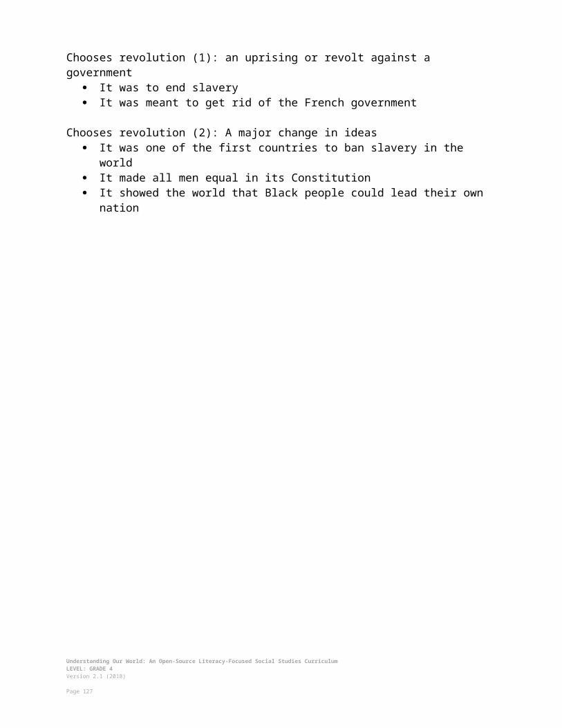
While students are trying to answer the questions, wait in the front of the room. Use the answer key to identify the correct places. Award points to the first three teams on the board or chart paper. After about 5 minutes tell students to stop. Have a student come up to the board and identify all the correct answers.
C. CLOSING (10 minutes)
8. Write Up Argument on the MidwestFor the evaluation task, have the students complete the exit ticket (ASSESSMENT 4-24.H), where they write their own personal response to the lesson’s Inquiry Question: “If you were to start a business in the Midwest United States, what would it be?” Tell students to cite at least three pieces of evidence from the sources.
Before using the exit ticket, consider using a graphic organizer or two column notes to prepare students for the writing task. Consider using sentence starters and modeling to help the students with their answer to the inquiry question.
EVALUATION
ASSESSMENT 4-24.H
Before using the exit ticket, consider using a graphic organizer or two column notes to prepare students for the writing task (generic examples are available in the Organizers section at the end of this Instructor Manual-before “Writing Rubric”). Consider using sentence starters and modeling to help the students with their answer to the inquiry question.
A generic writing rubric for evaluating exit tickets is located at the end of this Instructor Manual-before “Additional Resources.”
What to look for?
The students should take a stance on what type of business that they would start related to Midwest industries. All arguments should cite at least 3 pieces of evidence from the sources.
Some information that students may include in their answer to the question:
Trade Stocks and Futures in Illinois Would be an interesting job to have for numerous reasons Trading would be inside all day Invest in stocks, or own parts of companies Invest in futures, or make money from change prices in the future Be involved in the trading of corn, wheat, or cows
Understanding Our World: An Open-Source Literacy-Focused Social Studies CurriculumLEVEL: GRADE 4Version 2.1 (2018)
Page 127

Could make a lot of money or could lose a lot of money
Corn Farm in Iowa Would be an interesting job to have for numerous reasons Farming would be outside all day They produced more corn than any state Corn can be eaten and made into many different products (sweeteners,
vegetable oil, soap, paint) Most people eat corn
Shipping Company in Ohio Would be an interesting job to have for numerous reasons Shipping would be outside most of the time/be on a boat Shipping is very important ($1 billion dollars for Cleveland alone) Without ships, items cannot get sold Transport goods around the world
Cheese Factory in Wisconsin Would be an interesting job to have for numerous reasons Cheese making would be inside all day Wisconsin produces more cheese than any state There is a long history of cheese making in Wisconsin brought there by
European immigrants Cheese tastes good It would be fund to cheer for the Packers wearing a cheese hat
Cattle Ranch in North Dakota Would be an interesting job to have for numerous reasons Ranching would be outside all day Get to ride a horse Get to work at/near your house Could also be a veterinarian, economist, or meat seller
Understanding Our World: An Open-Source Literacy-Focused Social Studies CurriculumLEVEL: GRADE 4Version 2.1 (2018)
Page 128

LESSON PLAN 4-25: Southwest (U.S. Regions Mini-Unit)
MATERIALS
The Amazon Race Introduction Video (Lesson4-22-26Video1) [Located in the UOW Video Library: www.christophercmartell.com/understandingourworld]Clipboards (not supplied)Lined paper (not supplied)Amazing Race Challenge 7: Southwest Map (WORKSHEET 4-25.A)Source 1: Carlsbad Caverns (New Mexico) (SOURCEBOOK 4-25.B)Source 2: Monument Valley (Utah) (SOURCEBOOK 4-25.C)Source 3: Caddo Lake (Texas) (SOURCEBOOK 4-25.D)Source 4: Pikes Peak (Colorado) (SOURCEBOOK 4-25.E)Source 5: Petrified Forest (Arizona) (SOURCEBOOK 4-25.F)Amazing Race Challenge 8: Clues About Southwest Natural Areas
(WORKSHEET 4-25.G)Southwest: Exit Ticket (ASSESSMENT 4-25.H)
STANDARDS
Massachusetts History and Social Science Framework
MA-HSS.4.9: On a map of North America, locate the current boundaries of the United States (including Alaska and Hawaii). Locate the New England, Middle Atlantic, Atlantic Coast/Appalachian, Southeast/Gulf, South Central, Great Lakes, Plains, Southwest Desert, and Pacific states and the Commonwealth of Puerto Rico. (G)
MA-HSS.4.10: Identify the states, state capitals, and major cities in each region. (G)
MA-HSS.4.11: Describe the climate, major physical features, and major natural resources in each region. (G)
MA-HSS.4.15: Describe the diverse nature of the American people by identifying the distinctive contributions to American culture
Common Core: Literacy
CCSS.ELA-Literacy.RI.4.9: Integrate information from two texts on the same topic in order to write or speak about the subject knowledgeably.
CCSS.ELA-Literacy.RI.4.10: By the end of year, read and comprehend informational texts, including history/social studies, science, and technical texts, in the grades 4–5 text complexity band proficiently, with scaffolding as needed at the high end of the range.
Understanding Our World: An Open-Source Literacy-Focused Social Studies CurriculumLEVEL: GRADE 4Version 2.1 (2018)
Page 129

CCSS.ELA-Literacy.W.4.8: Recall relevant information from experiences or gather relevant information from print and digital sources; take notes and categorize information, and provide a list of sources.
CCSS.ELA-Literacy.W.4.9: Draw evidence from literary or informational texts to support analysis, reflection, and research.
PROCEDURES
Inquiry Question: What natural area in the Southwest United States is most important to protect?
PREPARATION
1. The Amazing Race ChallengeThis is lesson 4 of 5 that form a mini-unit on United States regional geography. This mini-unit will use the popular world-traveling game show Amazing Race as an organizing theme. Students should be put in pairs, just like on the game show, to complete in “geography challenges” (which appear between the opener and development, as well as the development and closure) where they were earn team points. You can choose to assign partners or let students choose their own partners (if you assign teams, be sure to have them determined before this lesson). Throughout the mini-unit, you should keep track of team points on the board or chart paper throughout the 5 lessons and consider announcing a winning team at the end of the mini-unit.
NOTE: To have time for the Amazing Race challenges, the lesson plans for the mini-unit on United States regional geography are 10 minutes longer than normal (55 minutes total). You should plan the block time accordingly.
2. Set Up StationsThis activity will involve stations where students will learn about different Southwest natural area. Before this block, put desks into 5 groups. Each group of desks will be the station for one natural area found in different states. At each station, put one (or multiple) copies of the handout for that station (i.e. SOURCEBOOK 4.25-B, 4.25-C, 4.25-D, 4.25-E, 4.25-F). Consider putting each in a sheet protector or dry erase pockets to protect them.
A. OPENER (10 minutes)
3. Watch the Amazing Race Introductory VideoShow the students a short video clip from the beginning of the show Amazon Race (Lesson4-22-26Video1) to get students excited about today’s challenges. Remind the students of the team points earned so far and that the team with the most points at the end will win. 4. Assign Teams
Understanding Our World: An Open-Source Literacy-Focused Social Studies CurriculumLEVEL: GRADE 4Version 2.1 (2018)
Page 130

Put students into their teams (chosen during Lesson 4-22). Each team should be a pair of two. Tell the students, “Alright teams, let’s begin day four of our Amazing Race around the United States.”
5. Amazing Race Challenge 7: Identify the Southwest StatesDisplay the Southwest Map (WORKSHEET 4-25.A) through a projector. Tell students, “Today we will travel to this region during the amazing race. This is the Southwest United States.”
Tell students that today we will be traveling to the important natural areas found in the states of the Southwest. You will need to decide which natural area that you think is most important to protect. Before we do that, we will have our first Amazing Race challenge.
Handout the blank map, which is page 1 of the Southwest Map (WORKSHEET 4-25.A) face down (so students cannot see it yet). Do not pass out the answer key.
Tell students on the count of three, each team should flip over the map and try to identify all the states in green (or darker gray, if it is not in color). Since the states are small, they can use abbreviations (like NM for New Mexico). You might want to post the names of the states on the board, as a word bank. First team who thinks they have labeled all the states correctly should bring it to the teacher. You will check the answers. The first team to identify all of the states will get 5 points, second team will get 3 points, and third team will get 1 point (if no team gets all of the states, award the points to the groups that had the most states correct first). Tell students, “3, 2, 1, go.”
While students are trying to identify the states, wait in the front of the room. Use the answer key to identify the states. Award points to the first three teams on the board or chart paper. After about 5 minutes tell students to stop. Have a student come up to the board and identify all the states correctly while each student fills in the state name correctly.
B. DEVELOPMENT (35 minutes)
6. Travel to Each Southwest Natural Area at the StationsGive students a clipboard with lined paper on it. Tell students that at each group of desks there is a different station that will teach you about a different natural area. Equally distribute students to each station.
Tell the students that the Southwest includes natural areas that are very special. Some of these natural areas have things that exist only in few places around the world. These natural areas also face environmental problems because of climate change and damage caused by tourists. You will have to decide which natural area is most important to protect.
Understanding Our World: An Open-Source Literacy-Focused Social Studies CurriculumLEVEL: GRADE 4Version 2.1 (2018)
Page 131

Ask students to look at the map of the Southwest that we labeled. Ask them, “if you have traveled to the Southwest, tell us what it was like?” Anticipated student responses may include: it was dry, people wore cowboy hats, it has cactuses, they visited the Grand Canyon, they went hiking or skiing there, they have family who live there. Ask students to describe the different places they have been in the Southwest. It is okay if some or many of your students have never visited the Southwest; this is to allow students that have to share their experiences and connect to the lesson topic.
Write on the board, “State, natural area, and 2-3 facts” and tell students that at each station they should write down the state’s name, the natural area listed, and list 2-3 reasons why it is important and needs to be protected. Tell students that these facts will help them in the next Amazing Race challenge and to do today’s exit ticket. Give students five minutes to read the posted handout at their first station and take notes.
Tell students to move clockwise and have them attend the next station (or, you can also rotate the sources and have the students stay stationary). Give students five minutes to read the posted handout at their second station and take notes.
Tell students to move clockwise and have them attend the next station. Give students five minutes to read the posted handout at their third station and take notes.
Tell students to move clockwise and have them attend the next station. Give students five minutes to read the posted handout at their fourth station and take notes.
Tell students to move clockwise and have them attend the next station. Give students five minutes to read the posted handout at their fifth station and take notes.
7. Amazing Race Challenge 8: Identify the Southwest Natural AreasHave students return to their seats, but sit next to their Amazing Race teammate. Handout the clues sheet (WORKSHEET 4-25.G) face down (so students cannot see it yet). Tell students that before they decide which Southwest natural area that they should protect, we will have our next Amazing Race challenge. They will need to use their notes on the Southwest natural areas to answer to five questions.
Tell students on the count of three, each team should flip over the sheet and try to answer all the questions correctly. First team who thinks they have labeled all the states/natural areas correctly should bring it to the teacher. Check their answers. The first team to identify all of the states/industries will get 5 points, second team will get 3 points, and third team will get 1 point. Tell students, “3, 2, 1, go.”
While students are trying to answer the questions, wait in the front of the room. Use the answer key to identify the correct places. Award points to the first three teams on the board or chart paper. After about 5 minutes tell students to stop. Have a student come up to the board and identify all the correct answers.
C. CLOSING (10 minutes)
Understanding Our World: An Open-Source Literacy-Focused Social Studies CurriculumLEVEL: GRADE 4Version 2.1 (2018)
Page 132

8. Write Up Argument on the SouthwestFor the evaluation task, have the students complete the exit ticket (ASSESSMENT 4-25.H), where they write their own personal response to the lesson’s Inquiry Question: “What natural area in the Southwest United States is most important to protect?” Tell students to cite at least three pieces of evidence from the sources.
Before using the exit ticket, consider using a graphic organizer or two column notes to prepare students for the writing task. Consider using sentence starters and modeling to help the students with their answer to the inquiry question.
EVALUATION
ASSESSMENT 4-25.H
Before using the exit ticket, consider using a graphic organizer or two column notes to prepare students for the writing task (generic examples are available in the Organizers section at the end of this Instructor Manual-before “Writing Rubric”). Consider using sentence starters and modeling to help the students with their answer to the inquiry question.
A generic writing rubric for evaluating exit tickets is located at the end of this Instructor Manual-before “Additional Resources.”
What to look for?
The students should take a stance on what natural area we should most protect. All arguments should cite at least 3 pieces of evidence from the sources.
Some information that students may include in their answer to the question:
Carlsbad Caverns (New Mexico) Deep caverns with stalactites and stalagmites in New Mexico Over 250 million years old Former ocean reef Was discovered by a boy who loved nearby Climate change is damaging the stalactites and stalagmites, because the cave
temperature is increasingMonument Valley (Utah)
Many sandstone buttes in Utah Located on the Navajo Reservation Many movies were filmed there, including Cars, The Lego Movie, Forrest Gump,
Back to the Future, Transformers, and Mission Impossible They mined uranium there for power plants and bombs Since there are expensive minerals there, some people want to dig them up and
ruin the environment
Understanding Our World: An Open-Source Literacy-Focused Social Studies CurriculumLEVEL: GRADE 4Version 2.1 (2018)
Page 133

Caddo Lake (Texas) Bayou and lake along the Texas-Louisiana border Named after the Caddo, who are a group of Indigenous people living in the area Largest area of flooded cypress tree forests in the United States Many animals live there, including owls, snakes, water birds, eagles, and
alligators Some people claim to have seen a “big foot” monster there The bayou and lake are being damaged by boats that hurt or kill wildlife and
pollute the water with oil and gas
Pikes Peak (Colorado) Highest mountain in the southern Rocky Mountains of Colorado The Ute people first saw it 2,500 years ago Spanish explorers called it El Capitán Has the highest railroad in North America Many animals live there, including raccoons, skunks, various squirrels, deer,
bears, and mountain lions With all of the cars, trucks, and houses in the area, there is often a lot of smog or
air pollution
Petrified Forest (Arizona) One of the largest collections of preserved pieces of wood or a “petrified forest”
in Arizona Petrified wood is wood that has turned to stone and is very rare Many people try to steal the petrified wood Hikers often do damage to the animal habitats or trees and plants in the area
Understanding Our World: An Open-Source Literacy-Focused Social Studies CurriculumLEVEL: GRADE 4Version 2.1 (2018)
Page 134

LESSON PLAN 4-26: West (U.S. Regions Mini-Unit)
MATERIALS
The Amazon Race Introduction Video (Lesson4-22-26Video1) [Located in the UOW Video Library: www.christophercmartell.com/understandingourworld]Clipboards (not supplied)Lined paper (not supplied)Amazing Race Challenge 9: West Map (WORKSHEET 4-26.A)Source 1: San Francisco Bay Area (California) (SOURCEBOOK 4-26.B)Source 2: Greater Los Angeles (California) (SOURCEBOOK 4-26.C)Source 3: Puget Sound (Washington) (SOURCEBOOK 4-26.D)Source 4: Willamette Valley (Oregon) (SOURCEBOOK 4-26.E)Source 5: Island of O’ahu (Hawaii) (SOURCEBOOK 4-26.F)Amazing Race Challenge 10: Clues About Metropolitan Areas in the West
(WORKSHEET 4-26.G)West: Exit Ticket (ASSESSMENT 4-26.H)
STANDARDS
Massachusetts History and Social Science Framework
MA-HSS.4.9: On a map of North America, locate the current boundaries of the United States (including Alaska and Hawaii). Locate the New England, Middle Atlantic, Atlantic Coast/Appalachian, Southeast/Gulf, South Central, Great Lakes, Plains, Southwest Desert, and Pacific states and the Commonwealth of Puerto Rico. (G)
MA-HSS.4.10: Identify the states, state capitals, and major cities in each region. (G)
MA-HSS.4.11: Describe the climate, major physical features, and major natural resources in each region. (G)
MA-HSS.4.15: Describe the diverse nature of the American people by identifying the distinctive contributions to American culture
Common Core: Literacy
CCSS.ELA-Literacy.RI.4.9: Integrate information from two texts on the same topic in order to write or speak about the subject knowledgeably.
CCSS.ELA-Literacy.RI.4.10: By the end of year, read and comprehend informational texts, including history/social studies, science, and technical texts, in the grades 4–5 text complexity band proficiently, with scaffolding as needed at the high end of the range.
Understanding Our World: An Open-Source Literacy-Focused Social Studies CurriculumLEVEL: GRADE 4Version 2.1 (2018)
Page 135

CCSS.ELA-Literacy.W.4.8: Recall relevant information from experiences or gather relevant information from print and digital sources; take notes and categorize information, and provide a list of sources.
CCSS.ELA-Literacy.W.4.9: Draw evidence from literary or informational texts to support analysis, reflection, and research.
PROCEDURES
Inquiry Question: If you had to move to the West United States, which metropolitan area would you move to?
PREPARATION
1. The Amazing Race ChallengeThis is lesson 5 of 5 that form a mini-unit on United States regional geography. This mini-unit will use the popular world-traveling game show Amazing Race as an organizing theme. Students should be put in pairs, just like on the game show, to complete in “geography challenges” (which appear between the opener and development, as well as the development and closure) where they were earn team points. You can choose to assign partners or let students choose their own partners (if you assign teams, be sure to have them determined before this lesson). Throughout the mini-unit, you should keep track of team points on the board or chart paper throughout the 5 lessons and consider announcing a winning team at the end of the mini-unit.
NOTE: To have time for the Amazing Race challenges, the lesson plans for the mini-unit on United States regional geography are 10 minutes longer than normal (55 minutes total). You should plan the block time accordingly.
2. Set Up StationsThis activity will involve stations where students will learn about different West metropolitan areas. Before this block, put desks into 5 groups. Each group of desks will be the station for one metropolitan area found in different states. At each station, put one (or multiple) copies of the handout for that station (i.e. SOURCEBOOK 4.26-B, 4.26-C, 4.26-D, 4.26-E, 4.26-F). Consider putting each in a sheet protector or dry erase pockets to protect them.
A. OPENER (10 minutes)
3. Watch the Amazing Race Introductory VideoShow the students a short video clip from the beginning of the show Amazon Race (Lesson4-22-26Video1) to get students excited about today’s challenges. Remind the students of the team points earned so far and that the team with the most points at the end will win. 4. Assign Teams
Understanding Our World: An Open-Source Literacy-Focused Social Studies CurriculumLEVEL: GRADE 4Version 2.1 (2018)
Page 136

Put students into their teams (chosen during Lesson 4-22). Each team should be a pair of two. Tell the students, “Alright teams, let’s begin day five of our Amazing Race around the United States. This will be our final day, and today, we will learn who wins the Amazing Race!”
5. Amazing Race Challenge 9: Identify the West StatesDisplay the West Map (WORKSHEET 4-26.A) through a projector. Tell students, “Today we will travel to this region during the amazing race. This is the West United States.”
Tell students that today we will be traveling to the major metropolitan areas found in the states of the West. You will need to decide which metropolitan area that you think would be best to move to. Before we do that, we will have our first Amazing Race challenge.
Handout the blank map, which is page 1 of the West Map (WORKSHEET 4-26.A) face down (so students cannot see it yet). Do not pass out the answer key.
Tell students on the count of three, each team should flip over the map and try to identify all the states in green (or darker gray, if it is not in color). Since the states are small, they can use abbreviations (like CA for California). You might want to post the names of the states on the board, as a word bank. First team who thinks they have labeled all the states correctly should bring it to the teacher. You will check the answers. The first team to identify all of the states will get 5 points, second team will get 3 points, and third team will get 1 point (if no team gets all of the states, award the points to the groups that had the most states correct first). Tell students, “3, 2, 1, go.”
While students are trying to identify the states, wait in the front of the room. Use the answer key to identify the states. Award points to the first three teams on the board or chart paper. After about 5 minutes tell students to stop. Have a student come up to the board and identify all the states correctly while each student fills in the state name correctly.
B. DEVELOPMENT (35 minutes)
6. Travel to Each West Metropolitan Area at the StationsGive students a clipboard with lined paper on it. Tell students that at each group of desks there is a different station that will teach you about a different area. Equally distribute students to each station.
Write the word “Metropolitan” on the board or chart paper. Tell the students that the West has several large metropolitan areas. Ask students if they know what the word metropolitan means. Anticipated student responses may include: large, many people, far away. Next, write the definition of metropolitan as, “a city and surrounding towns where people live.” In the West, there is a lot of country side and these few very large cities and suburbs (towns outside cities) where most people live. For instance, there are as many people in the San Francisco Bay Area alone (about 7 million people) as the entire state of Massachusetts. Greater Los Angeles has 18 million people, which is
Understanding Our World: An Open-Source Literacy-Focused Social Studies CurriculumLEVEL: GRADE 4Version 2.1 (2018)
Page 137

more than two times more people than Massachusetts. You will have to decide, if you were to move to the West, which metropolitan area would you move to.
Ask students to look at the map of the West that we labeled. Ask them, “if you have traveled to the West, tell us what it was like?” Anticipated student responses may include: it was dry, it was sunny, there are many cars there, there were palm trees. Ask students to describe the different places they have been in the West. It is okay if some or many of your students have never visited the West; this is to allow students that have to share their experiences and connect to the lesson topic.
Write on the board, “Metropolitan area, and 2-3 facts” and tell students that at each station they should write down the area’s name and list 2-3 reasons why it is important and you may want to move there. Tell students that these facts will help them in the next Amazing Race challenge and to do today’s exit ticket. Give students five minutes to read the posted handout at their first station and take notes.
Tell students to move clockwise and have them attend the next station (or, you can also rotate the sources and have the students stay stationary). Give students five minutes to read the posted handout at their second station and take notes.
Tell students to move clockwise and have them attend the next station. Give students five minutes to read the posted handout at their third station and take notes.
Tell students to move clockwise and have them attend the next station. Give students five minutes to read the posted handout at their fourth station and take notes.
Tell students to move clockwise and have them attend the next station. Give students five minutes to read the posted handout at their fifth station and take notes.
7. Amazing Race Challenge 10: Identify the West Metropolitan AreasHave students return to their seats, but sit next to their Amazing Race teammate. Handout the clues sheet (WORKSHEET 4-26.G) face down (so students cannot see it yet). Tell students that before they decide which West metropolitan area that they would move to, we will have our next Amazing Race challenge. They will need to use their notes on the West metropolitan areas to answer to five questions.
Tell students on the count of three, each team should flip over the sheet and try to answer all the questions correctly. First team who thinks they have labeled all the states/natural areas correctly should bring it to the teacher. Check their answers. The first team to identify all of the states/industries will get 5 points, second team will get 3 points, and third team will get 1 point. Tell students, “3, 2, 1, go.”
While students are trying to answer the questions, wait in the front of the room. Use the answer key to identify the correct places. Award points to the first three teams on the board or chart paper. After about 5 minutes tell students to stop. Have a student come up to the board and identify all the correct answers.
Understanding Our World: An Open-Source Literacy-Focused Social Studies CurriculumLEVEL: GRADE 4Version 2.1 (2018)
Page 138

C. CLOSING (10 minutes)
8. Write Up Argument on the WestFor the evaluation task, have the students complete the exit ticket (ASSESSMENT 4-26.H), where they write their own personal response to the lesson’s Inquiry Question: “If you had to move to the West United States, which metropolitan area would you move to?” Tell students to cite at least three pieces of evidence from the sources.
Before using the exit ticket, consider using a graphic organizer or two column notes to prepare students for the writing task. Consider using sentence starters and modeling to help the students with their answer to the inquiry question.
EVALUATION
ASSESSMENT 4-26.H
Before using the exit ticket, consider using a graphic organizer or two column notes to prepare students for the writing task (generic examples are available in the Organizers section at the end of this Instructor Manual-before “Writing Rubric”). Consider using sentence starters and modeling to help the students with their answer to the inquiry question.
A generic writing rubric for evaluating exit tickets is located at the end of this Instructor Manual-before “Additional Resources.”
What to look for?
The students should take a stance on where they would move. All arguments should cite at least 3 pieces of evidence from the sources.
Some information that students may include in their answer to the question:
San Francisco Bay Area (California) Technology industry (companies like Google, Apple, Facebook, Intel, and
Hewlett-Packard) Important landmarks: Golden Gate Bridge and cable cars Like the weather: foggy and cool Personal connection (like family live there)
Greater Los Angeles (California) Movie and music industry (studios like Disney, Warner Brothers, Sony,
Paramount) Important landmarks: Hollywood Sign Like the weather: sunny and warm Personal connection (like family live there)
Understanding Our World: An Open-Source Literacy-Focused Social Studies CurriculumLEVEL: GRADE 4Version 2.1 (2018)
Page 139

Puget Sound (Washington) Natural areas (orca whales and mountains) Important landmarks: Space Needle Like the weather: cool and rainy Personal connection (like family live there)
Willamette Valley (Oregon) Art and farming (grapes, berries, vegetables) Important landmarks: White Stag Sign Like the weather: hot and dry summer; cool and rainy winter Personal connection (like family live there)
Island of O’ahu (Hawaii) Beautiful beaches and important history (Kingdom of Hawaii) Important landmarks: Iolani Palace, Diamondhead Like the weather: warm and sunny Personal connection (like family live there)
Understanding Our World: An Open-Source Literacy-Focused Social Studies CurriculumLEVEL: GRADE 4Version 2.1 (2018)
Page 140

LESSON PLAN 4-27: Latin America Today: Diverse Nations, Diverse People
MATERIALS
Traveling Across Latin America Video (Lesson4-27Video1) [Located in the UOW Video Library: www.christophercmartell.com/understandingourworld]Clipboard (not supplied)8 Latin American Countries Notes and Latin America Map (WORKSHEET 4-27.A)Source 1: Ecuador (SOURCEBOOK 4-27.B)Source 2: Peru (SOURCEBOOK 4-27.C)Source 3: Argentina (SOURCEBOOK 4-27.D)Source 4: Brazil (SOURCEBOOK 4-27.E)Source 5: Guatemala (SOURCEBOOK 4-27.F)Source 6: Haïti (SOURCEBOOK 4-27.G)Source 7: Dominican Republic (SOURCEBOOK 4-27.H)Source 8: Jamaica (SOURCEBOOK 4-27.I)Latin America Today: Exit Ticket (ASSESSMENT 4-27.J)
STANDARDS
Massachusetts History and Social Science Framework
MA-HSS.4.29: Identify the different languages used in different countries in the Caribbean region today (e.g., Spanish in Cuba, French in Haiti, English in Barbados and Jamaica). (H)
MA-HSS.4.30: Identify when the countries in the Caribbean and in Central America became independent nations and explain how independence was achieved. (H, G)
Common Core: Literacy
CCSS.ELA-Literacy.RI.4.9: Integrate information from two texts on the same topic in order to write or speak about the subject knowledgeably.
CCSS.ELA-Literacy.RI.4.10: By the end of year, read and comprehend informational texts, including history/social studies, science, and technical texts, in the grades 4–5 text complexity band proficiently, with scaffolding as needed at the high end of the range.
CCSS.ELA-Literacy.W.4.8: Recall relevant information from experiences or gather relevant information from print and digital sources; take notes and categorize information, and provide a list of sources.
CCSS.ELA-Literacy.W.4.9: Draw evidence from literary or informational texts to support analysis, reflection, and research.
Understanding Our World: An Open-Source Literacy-Focused Social Studies CurriculumLEVEL: GRADE 4Version 2.1 (2018)
Page 141

PROCEDURES
Inquiry Question: If you were to visit Latin America today, what country would you choose and why?
PREPARATION
1. Set Up Carousel ActivityAround the room, post the eight sources: Ecuador (SOURCEBOOK 4-27.B), Peru (SOURCEBOOK 4-27.C), Argentina (SOURCEBOOK 4-27.D), Brazil (SOURCEBOOK 4-27.E), Guatemala (SOURCEBOOK 4-27.F), Haïti (SOURCEBOOK 4-27.G), Dominican Republic (SOURCEBOOK 4-27.H), Jamaica (SOURCEBOOK 4-27.I)
A. OPENER (10 minutes)
2. Watch Traveling Across Latin America VideoShow the students a short video of French Canadian citizen Frank as he travels to 15 Latin American countries over five months (Lesson4-27Video1). At the end of the video, tell students that today, just like Frank, you will look at 8 different countries in Latin America and have to decide which one you most want to travel to.
Tell the students that “Frank traveled around Latin America. Latin America includes the countries of the Caribbean, Central American, and South America. We use that name, because they use languages that come from Latin, including Spanish, Portuguese, and French” (NOTE: As a Patois- and English-speaking country, Jamaica is not usually included in Latin America. It is included in this lesson because it has an important role in Caribbean culture). Show students on the map where the Caribbean is, where Central America is, and where South America is. Explain that in Latin America most people live in cities, called urban areas, located near natural areas that often very rural, or have fewer people living there.
B. DEVELOPMENT (20 minutes)
3. Engage in a Carousel Activity on 8 Latin American CountriesGive each student a pencil and clipboard with the 8 Latin American Countries Notes and Latin America Map (WORKSHEET 4-27.A) on it. Ask students to go to each of the eight stations (4-27.B, 4-27.C, 4-27.D, 4-27.E, 4-27.F, 4-27.G, 4-27.H). At each station, the students should take notes on each country.
Once students have gone to each of the eight stations, they should return to their seats. Put students in small groups. Have them look at their note sheets and discuss the top 3 Latin American countries that they would like to visit and explain why they would like to visit those countries.
C. CLOSING (15 minutes)
Understanding Our World: An Open-Source Literacy-Focused Social Studies CurriculumLEVEL: GRADE 4Version 2.1 (2018)
Page 142

4. Write Up Argument on 8 Latin American CountriesFor the evaluation task, have the students complete the exit ticket (ASSESSMENT 4-27.I), where they write their own personal response to the lesson’s Inquiry Question: “If you were to visit Latin America today, what country would you choose and why?” Tell students to cite at least three pieces of evidence from the sources.
Before using the exit ticket, consider using a graphic organizer or two column notes to prepare students for the writing task. Consider using sentence starters and modeling to help the students with their answer to the inquiry question.
EVALUATION
ASSESSMENT 4-27.I
Before using the exit ticket, consider using a graphic organizer or two column notes to prepare students for the writing task (generic examples are available in the Organizers section at the end of this Instructor Manual-before “Writing Rubric”). Consider using sentence starters and modeling to help the students with their answer to the inquiry question.
A generic writing rubric for evaluating exit tickets is located at the end of this Instructor Manual-before “Additional Resources.”
What to look for?
The students should take a stance on the Latin American country that they would most like to visit and explain why. All arguments should cite at least 3 pieces of evidence from the sources.
Some information that students may include in their answer to the question:
Reasons to choose Ecuador: I have family members/friends/ancestors who live there I love science or nature Want to visit the Galapagos Islands (i.e. tortoises, penguins, iguanas) Want to visit a city in the Andes Mountains Want to be in a Spanish-speaking place
Reasons to choose Peru: I have family members/friends/ancestors who live there I love history/want to know more about the Incas Want to visit Machu Picchu Want to climb mountains Want to see alpacas and llamas Want to learn about Quechua people and the Quechua language
Understanding Our World: An Open-Source Literacy-Focused Social Studies CurriculumLEVEL: GRADE 4Version 2.1 (2018)
Page 143

Want to be in a Spanish-speaking place
Reasons to choose Argentina: I have family members/friends/ancestors who live there I love technology and computers Want to work for a technology/computer company Want to visit a place with a lot of technology Think an online travel agent is a good idea Want to be in a Spanish-speaking place
Reasons to choose Brazil: I have family members/friends/ancestors who live there I love yhe beach and nature Want to visit Rio de Janeiro/beaches Want to climb to the top of Sugarloaf or Cristo Redentor statue Want to visit the Amazon River and rainforest/see the animals there Want to be in a Portuguese-speaking place
Reasons to choose Guatemala: I have family members/friends/ancestors who live there I love hiking and camping Want to visit Tikal and the heart of the Maya Empire/climb the temple Want to see a volcano/Acatenango Volcano Want to go hiking and camping Want to be in a Spanish-speaking place
Reasons to choose Haïti: I have family members/friends/ancestors who live there I love busy cities and shopping at markets Want to see the colorful houses of Port-au-Prince Want to buy Haitian clothes and goods Want to eat Haitian food, like riz national (rice and beans usually served with fish,
chicken, or goat) and legume (vegetable stew) Want to be in a Haitian Creole-speaking place
Reasons to choose the Dominican Republic: I have family members/friends/ancestors who live there I love dancing and baseball Want to be in a place with warm nights Want to see future Major League baseball players Want to be in a Spanish-speaking place
Reasons to choose Jamaica: I have family members/friends/ancestors who live there I love athletes, music (reggae), and food
Understanding Our World: An Open-Source Literacy-Focused Social Studies CurriculumLEVEL: GRADE 4Version 2.1 (2018)
Page 144

Want to cheer for Usain Bolt, who is the world’s fastest runner Want to visit the home/listen to the music of Bob Marley, who brought reggae to
the rest of the world Want to eat Jamaican food, like jerk chicken, curry goat, and rice and peas Want to be in a Patois or English-speaking place
Understanding Our World: An Open-Source Literacy-Focused Social Studies CurriculumLEVEL: GRADE 4Version 2.1 (2018)
Page 145

LESSON PLAN 4-28: The Great European Empires: Greece, Rome, Spain, France, and Britain
MATERIALS
Lined paper (not supplied) Image (SOURCEBOOK 4-28.A)Source 1: Greece (SOURCEBOOK 4-28.B)Source 2: Rome (SOURCEBOOK 4-28.C)Source 3: Spain (SOURCEBOOK 4-28.D)Source 4: France (SOURCEBOOK 4-28.E)Source 5: Britain (SOURCEBOOK 4-28.F)European Empires: Digital Slideshow Instructions (WORKSHEET 4-28.G)The Great European Empires: Exit Ticket (ASSESSMENT 4-28.H)
STANDARDS
Massachusetts History and Social Science Framework
MA-HSS.4.14: Identify the five different European countries (France, Spain, England, Russia, and the Netherlands) that influenced different regions of the present United States at the time the New World was being explored and describe how their influence can be traced to place names, architectural features, and language. (H, G)
Common Core: Literacy
CCSS.ELA-Literacy.RI.4.9: Integrate information from two texts on the same topic in order to write or speak about the subject knowledgeably.
CCSS.ELA-Literacy.RI.4.10: By the end of year, read and comprehend informational texts, including history/social studies, science, and technical texts, in the grades 4–5 text complexity band proficiently, with scaffolding as needed at the high end of the range.
CCSS.ELA-Literacy.W.4.8: Recall relevant information from experiences or gather relevant information from print and digital sources; take notes and categorize information, and provide a list of sources.
CCSS.ELA-Literacy.W.4.9: Draw evidence from literary or informational texts to support analysis, reflection, and research.
PROCEDURES
Understanding Our World: An Open-Source Literacy-Focused Social Studies CurriculumLEVEL: GRADE 4Version 2.1 (2018)
Page 146

Inquiry Question: If you could live in any European empire, which one would it be and why?
PREPARATION
This lesson uses a method called Visual Thinking Strategy (VTS). The key to VTS is that you as a teacher only do two things: (1) Ask the following questions and (2) repeat as precisely as possible exactly what the students say.
Visual Thinking Strategy Questions: Open with: “What’s going on in this picture?”
Summarize student responses using conditional language (“Raoul thinks this could be…”). This keeps the conversation open to other interpretations by other students.
If appropriate: “What do you see that makes you say that?”This encourages students to back up their statements with things they see in the work of art.
Ask the group: “What more can we find?”This continues the conversation.
If this is your first time using VTS, I would recommend reading this description (with a video example from Grade 1) of it from the Milwaukee Art Museum: http://teachers.mam.org/collection/teaching-with-art/visual-thinking-strategies-vts/
1. Two-Day LessonThis lesson spans over two days. Day 1 involves learning about the European empires and drafting slideshows. Day 2 includes presenting slideshows. You should choose whatever digital slideshow platform that you feel is best for your students and is available to your school (i.e. PowerPoint, Google Slides, Prezi).
2. Reference Books and Computer AccessBefore the lesson, the teacher should prepare 2-3 reference books (possibly with the help of a librarian) on the history of these empires: Greece, Rome, Spain, France, and Britain. Students will need computer access (lab or laptops) to create their digital slide shows and a computer projector for the presentations.
DAY 1
A. OPENER (10 minutes)
Understanding Our World: An Open-Source Literacy-Focused Social Studies CurriculumLEVEL: GRADE 4Version 2.1 (2018)
Page 147

3. Engage in a Visual Thinking Strategy (VTS) on Greek Acropolis ImageGive students Images (SOURCEBOOK 4-28.A). Do not reveal that this is an image of the Greek Acropolis in Ancient Greece, which was the center of the Greek civilization and housed the Parthenon. Project the image and tell the students to look at the image closely and quietly. Give them about one minute. Next, begin the VTS question about the image. Use the above questions, following VTS instructions. Have students inquire about the question using the above questions for about 2-3 minutes.
Tell students that today we will be learning about five European empires. They ruled over large parts of Europe at different times. Tell students that the image that we just looked at was an artist’s painting of what the Acropolis would have looked like. The Acropolis was the center of the Greek Empire and had several famous buildings (many still standing today) like the Parthenon and the Temple of Nike (the Greek god that the shoe company is named after). You had many good observations of the pictures. From the pictures, what do you think life was like in the Greek empire? Anticipated answers may include: they lived in a large city, people look very busy/many people, they lived on a hill.
B. DEVELOPMENT (15 minutes)
4. Examine Sources About the European EmpiresPut students into five groups. Assign each group an empire: Greece, Rome, Spain, France, Britain. Give them the corresponding source to their group: Greece (SOURCEBOOK 4-28.B), Rome (SOURCEBOOK 4-28.C), Spain (SOURCEBOOK 4-28.D), France (SOURCEBOOK 4-28.E), and Britain (SOURCEBOOK 4-28.F). Have students take turns reading aloud (using choral, partner, or independent reading) the sources to the whole class.
5. Plan Slideshows for the European EmpiresTell students that this is a two-day lesson. Today, we will be doing research on our assigned empires and creating a slideshow. Next class, each group will present on their European empire using a digital slideshow. Students will use their presentations to convince their peers to choose their empire as the place where they would want to live. We will have a vote at the end.
In their small groups, have the students read their specific source again. As the student reads, tell the other group members to underline or highlight any important information. Pass out reference books and/or give students access to computers. Read to students the directions on the sheet called European Empires: Digital Slideshow Instructions (WORKSHEET 4-28.G).
Students should collect information about their empires based on the questions listed on European Empires: Digital Slideshow Instructions (WORKSHEET 4-28.G). Students should build their digital slideshows using a computer and the digital slideshow platform chosen by the teacher (i.e. PowerPoint, Google Slides, Prezi).
Understanding Our World: An Open-Source Literacy-Focused Social Studies CurriculumLEVEL: GRADE 4Version 2.1 (2018)
Page 148

C. CLOSING (20 minutes)
6. Create Slideshows for the European EmpiresStudents should create a digital slideshow for their empires based on the questions listed on European Empires: Digital Slideshow Instructions (WORKSHEET 4-28.G). It should include three sections on way of life, climate, and trade, as well as three images related to the empire.
DAY 2
A. OPENER (10 minutes)
7. Complete Slideshows for the European EmpiresStudents should finish their slideshows advertising their empires to their peers based on the questions listed on European Empires: Digital Slideshow Instructions (WORKSHEET 4-28.G). It should include three sections on way of life, climate, and trade, as well as three images related to the empire. Have students practice giving their presentation at least once. Tell students that each group member should speak at least once during the presentation.
B. DEVELOPMENT (20 minutes)
8. Share Slideshows on European EmpiresStudents will listen and take notes on lined paper on the various presentations. Write on the board: “2 facts that support living in this empire and 2 facts that are against living in this empire.” Pass out lined paper.
Each group member should stand up at the front of the room and help give the presentation. Each student should speak at least once.
NOTE: There may be students that have disabilities that prevent them from speaking in front of the class. Be mindful of this and find different ways that they can contribute to the presentation.
C. CLOSING (15 minutes)
9. Write Up Argument on the European EmpiresFor the evaluation task, have the students complete the exit ticket (ASSESSMENT 4-28.H), where they write their own personal response to the lesson’s Inquiry Question: “If you could live in any European empire, which one would it be and why?” Tell students to cite at least three pieces of evidence from their notes on the presentation. They may
Understanding Our World: An Open-Source Literacy-Focused Social Studies CurriculumLEVEL: GRADE 4Version 2.1 (2018)
Page 149

speak with the presentation group members, if they need more information or did not write something down.
Before using the exit ticket, consider using a graphic organizer or two column notes to prepare students for the writing task. Consider using sentence starters and modeling to help the students with their answer to the inquiry question.
EVALUATION
ASSESSMENT 4-28.G
Before using the exit ticket, consider using a graphic organizer or two column notes to prepare students for the writing task (generic examples are available in the Organizers section at the end of this Instructor Manual-before “Writing Rubric”). Consider using sentence starters and modeling to help the students with their answer to the inquiry question.
A generic writing rubric for evaluating exit tickets is located at the end of this Instructor Manual-before “Additional Resources.”
What to look for?
The students should take a stance on what European empire they would live in. All arguments should cite at least 3 pieces of evidence from the sources or their independent research.
Some information that students may include in their answer to the question:
Greece My ancestors came from there It was a large empire with many people, including 315,000 in its capital of Athens It was on a peninsula in the Mediterranean Sea Good climate: warm and rainy winters (never gets below freezing) and hot and
dry summers Had democracy where all men voted on issues Had important buildings on the Acropolis, including the Parthenon and Temple of
Nike Traded many items: olive oil, wine, pottery, and metal They had a better (or worse) class system
Rome My ancestors came from there It was a large empire with many people, including 1 million in its capital of Rome It was on a peninsula in the Mediterranean Sea Had democracy where men elected politicians to make decisions for them
Understanding Our World: An Open-Source Literacy-Focused Social Studies CurriculumLEVEL: GRADE 4Version 2.1 (2018)
Page 150

Good climate: warm and rainy winters (never gets below freezing) and hot and dry summers
Had gladiator fights in the Coliseum They were great warriors Traded many items: olive oil, wine, pottery, and papyrus They had a better (or worse) class system
Spain My ancestors came from there It was a large empire with many people, including 400,000 in its capital of Madrid It was on a peninsula in Atlantic Ocean and Mediterranean Sea Had a king and queen Good climate: warm and rainy winters (never gets below freezing) and hot and
dry summers Were explorers Traded many items: including spices (but also weapons and enslaved people,
which was bad)
France My ancestors came from there It was a large empire with many people, including 600,000 in its capital of Paris It was on the Seine River on the European continent Had a king, then a dictator, then a king Good climate: cool and rainy winters (with dustings of snow) and warm summers Good military Traded many items: wine, olive oil, dyes, but much of their wealth came from
bringing items to Europe from other countries (imports)
Britain My ancestors came from there It was a large empire with many people, including 1 million in its capital of
London It was on the River Thames on an island in the Atlantic Ocean Had a king or queen Good climate: cool and rainy winters (with dustings of snow) and warm summers Good navy Much of their wealth came from bringing items to Europe from other countries
(imports)
Understanding Our World: An Open-Source Literacy-Focused Social Studies CurriculumLEVEL: GRADE 4Version 2.1 (2018)
Page 151

LESSON PLAN 4-29: Irish Independence: A New Country from an Ancient People
MATERIALS
A Brief History of Ireland (Lesson4-29Video1) [Located in the UOW Video Library: www.christophercmartell.com/understandingourworld]Source 1: Ancient Celtic History (SOURCEBOOK 4-29.A)Source 2: Treatment by the British (SOURCEBOOK 4-29.B)Source 3: Self-Rule and Free State (Government) (SOURCEBOOK 4-29.C)Irish Independence: Exit Ticket (ASSESSMENT 4-29.D)
STANDARDS
Massachusetts History and Social Science Framework
MA-HSS.4.16: Identify major immigrant groups that live in Massachusetts and where they now live in large numbers (e.g., English, Irish, Italians, French Canadians, Armenians, Greeks, Portuguese, Haitians, and Vietnamese). (H, G)
Common Core: Literacy
CCSS.ELA-Literacy.RI.4.9: Integrate information from two texts on the same topic in order to write or speak about the subject knowledgeably.
CCSS.ELA-Literacy.RI.4.10: By the end of year, read and comprehend informational texts, including history/social studies, science, and technical texts, in the grades 4–5 text complexity band proficiently, with scaffolding as needed at the high end of the range.
CCSS.ELA-Literacy.W.4.8: Recall relevant information from experiences or gather relevant information from print and digital sources; take notes and categorize information, and provide a list of sources.
CCSS.ELA-Literacy.W.4.9: Draw evidence from literary or informational texts to support analysis, reflection, and research.
PROCEDURES
Inquiry Question: Why was Irish independence from England so important to its people?
A. OPENER (10 minutes)
Understanding Our World: An Open-Source Literacy-Focused Social Studies CurriculumLEVEL: GRADE 4Version 2.1 (2018)
Page 152

1. Watch the Brief History of Ireland VideoShow the students a short cartoon video explaining the history of Ireland (Lesson4-2Video1). During the video, stop it and highlight/ask questions about how the major events of Irish history, including the Celts settling in the area, St. Patrick bringing Christianity there, the Vikings, the Norman invasion, James I takes over Ireland, English take Irish farms, Irish potato famine/Irish people immigrate to Liverpool, England, and America, Easter Rising/Irish War of Independence, become a republic/independent. After watching the video, ask the students, did something in the video show us why the Irish people wanted independence or to have their own country (not be part of Britain). Anticipated student responses may include: the Celts settled the island first, they were forced to be part of Britain, they had their land taken away, many people left during the potato famine, they were not allowed to have their own government, the British fought them several times.
B. DEVELOPMENT (20 minutes)
2. Read About the Different Reasons for Irish IndependencePut students in small groups and assign them one of the sources: Ancient Celtic History (SOURCEBOOK 4-29.A), Treatment by British (SOURCEBOOK 4-29.B), Self-Rule and Free State (Government) (SOURCEBOOK 4-29.C). Have one student from each group read their source. As the student reads, tell the other group members to underline or highlight any important information.
3. Engage in a Jig Saw About Irish IndependenceHave students participate in a jig saw activity. Make new groups where at least one student from each of the original groups is included. This will create several new groups of three students, one is an expert on 4-29.A, 4-29.B, 4-29.C. Have each student describe their document to the other members of their group.
Ask students to use the sources to answer the following inquiry question: “Why was Irish independence from England so important to its people?” In answering this question, students should debate between the three different worksheets. After students have discussed the question, they should complete the exit ticket in the following step. Circulate the room, helping the students who may have difficulty choosing one asset.
C. CLOSING (15 minutes)
4. Write Up Argument on Irish IndependenceFor the evaluation task, have the students complete the exit ticket (ASSESSMENT 4-29.D), where they write their own personal response to the lesson’s Inquiry Question: “Why was Irish independence from England so important to its people?” and choose the part they think was most important. Tell students to cite at least three pieces of evidence from the sources for this lesson.
Understanding Our World: An Open-Source Literacy-Focused Social Studies CurriculumLEVEL: GRADE 4Version 2.1 (2018)
Page 153

Before using the exit ticket, consider using a graphic organizer or two column notes to prepare students for the writing task. Consider using sentence starters and modeling to help the students with their answer to the inquiry question.
EVALUATION
ASSESSMENT 4-29.D
Before using the exit ticket, consider using a graphic organizer or two column notes to prepare students for the writing task (generic examples are available in the Organizers section at the end of this Instructor Manual-before “Writing Rubric”). Consider using sentence starters and modeling to help the students with their answer to the inquiry question.
A generic writing rubric for evaluating exit tickets is located at the end of this Instructor Manual-before “Additional Resources.”
What to look for?
The students should take a stance on why Irish independence was so important. All arguments should cite at least 3 pieces of evidence from the sources.
Some information that students may include in their answer to the question:
Ancient Celtic History The Celts have a long history of living on the island of Éire or Ireland (since 500
BCE) Normans (from France) took over their island In the 1600s, King James I of England invaded Ireland and made it part of the
British empire This lead to the Irish having a strong identity People continued to speak Gaelic (or Irish), celebrate Irish holidays, eat Irish
foods, and practice Catholicism
Treatment by the British When the British took over Ireland in the early 1600s, they treated the Irish
people very poorly The English brought English and Scottish colonists to Ireland, where they owned
the land and oversaw farms They were a different religion and did not respect the Catholicism of the Irish
people Between 1845-49 there was a terrible famine (An Gorta Mór) and the British
landowners still demanded that the Irish people pay them money or crops (despite many people starving)
3 million people died or left Ireland
Understanding Our World: An Open-Source Literacy-Focused Social Studies CurriculumLEVEL: GRADE 4Version 2.1 (2018)
Page 154

Self-Rule and Free State (Government) Starting in the 1880s, the Irish people began protesting for “home rule” or the
power to be their own government In 1919, the Irish fought a war of independence against the British government
(Irish Republican Army) 14 people were killed while watching a Gaelic football match during Bloody
Sunday (November 21, 1920) At the end of the war the British government gave southern Ireland its
independence The Irish people created the Oireachtas, which was their own democratic
government
Understanding Our World: An Open-Source Literacy-Focused Social Studies CurriculumLEVEL: GRADE 4Version 2.1 (2018)
Page 155

LESSON PLAN 4-30: Backpacking Across Europe: Diverse Nations, Diverse People
MATERIALS
Backpacking Europe Video (Lesson4-30Video1) [Located in the UOW Video Library: www.christophercmartell.com/understandingourworld]Drawing paper (not supplied)Markers and crayons (not supplied)Source 1: United Kingdom (SOURCEBOOK 4-30.A)Source 2: France (SOURCEBOOK 4-30.B)Source 3: Spain (SOURCEBOOK 4-30.C)Source 4: Italy (SOURCEBOOK 4-30.D)Source 5: Greece (SOURCEBOOK 4-30.E)Source 6: Germany (SOURCEBOOK 4-30.F)Source 7: Poland (SOURCEBOOK 4-30.G)Source 8: Sweden (SOURCEBOOK 4-30.H)Backpacking Europe: Travel Brochure Instructions (WORKSHEET 4-30.I)Backpacking Europe: Exit Ticket (ASSESSMENT 4-30.J)
STANDARDS
Massachusetts History and Social Science Framework
MA-HSS.4.16: Identify major immigrant groups that live in Massachusetts and where they now live in large numbers (e.g., English, Irish, Italians, French Canadians, Armenians, Greeks, Portuguese, Haitians, and Vietnamese). (H, G)
Common Core: Literacy
CCSS.ELA-Literacy.RI.4.9: Integrate information from two texts on the same topic in order to write or speak about the subject knowledgeably.
CCSS.ELA-Literacy.RI.4.10: By the end of year, read and comprehend informational texts, including history/social studies, science, and technical texts, in the grades 4–5 text complexity band proficiently, with scaffolding as needed at the high end of the range.
CCSS.ELA-Literacy.W.4.8: Recall relevant information from experiences or gather relevant information from print and digital sources; take notes and categorize information, and provide a list of sources.
CCSS.ELA-Literacy.W.4.9: Draw evidence from literary or informational texts to support analysis, reflection, and research.PROCEDURES
Understanding Our World: An Open-Source Literacy-Focused Social Studies CurriculumLEVEL: GRADE 4Version 2.1 (2018)
Page 156

Inquiry Question: If you were to backpack across Europe today, what country would you most want to visit and why?
1. Reference Books and Computer AccessBefore the lesson, the teacher should prepare 2-3 reference books (possibly with the help of a librarian) on each of the included countries: United Kingdom, France, Spain,Italy, Greece, Germany, Poland, and Sweden. While this lesson can be done with reference books alone, it is recommended that the students also have access to computers to do independent research on their countries. Computer access would be needed on Day 1.
2. Two- or Three-Day LessonThis lesson spans over two or three days. Day 1 and Day 2 involves learning about eight different European countries and drafting travel brochures for those countries. Day 2 or 3 includes presenting the travel brochures. This lesson works best over three days but may be reduced to three days to save time.
DAY 1
A. OPENER (10 minutes)
3. Watch the Backpacking Europe VideoShow the students a short video made by Richard Salinas, who is an American documenting his backpacking trip in 2016 around Europe (Lesson4-30Video1). During the video, stop it and highlight/ask questions about how the places in Europe are similar and different the students hometown. After watching the video, ask the students to list ways that Europe is similar and different to the United States. List their ideas on the board or chart paper within two columns: “similar” and “different.” Anticipated student responses may include: airplanes/trains/boats, we don’t have an Eiffel Tower, tall buildings/churches, beaches, ancient buildings, art/music/dancing, windmills, marketplaces/farmers markets.
Tell students that today, we are going to learn about different countries in Europe and you will make travel brochures advertising fun and exciting places your classmates might decide to visit. At the end, you will have to decide what country would be most important to visit if you, like Richard, were backpacking across Europe.
B. DEVELOPMENT (15 minutes)
4. Assign Groups and Examine Sources About CountryPut students into 8 different groups. Assign each group a specific country: United Kingdom, France, Spain, Italy, Greece, Germany, Poland, and Sweden that coincides with the sources. Tell students that this is a two-day lesson. Today, we will be doing research on our assigned country and creating a travel brochure to advertise it to others in the class. Next class, we will have a “Travel Fair,” where students will pretend that
Understanding Our World: An Open-Source Literacy-Focused Social Studies CurriculumLEVEL: GRADE 4Version 2.1 (2018)
Page 157

they will be backpacking to Europe and they will have to pick the country that they would most like to visit.
In their small groups, have the students read their specific source: United Kingdom (SOURCEBOOK 4-30.A), France (SOURCEBOOK 4-30.B), Spain (SOURCEBOOK 4-30.C), Italy (SOURCEBOOK 4-30.D), Greece (SOURCEBOOK 4-30.E), Germany (SOURCEBOOK 4-30.F), Poland (SOURCEBOOK 4-30.G), Sweden (SOURCEBOOK 4-30.H). As the student reads, tell the other group members to underline or highlight any important information. Pass out reference books and/or give students access to computers. Read to students the directions on the sheet called Backpacking Europe: Travel Brochure Instructions (WORKSHEET 4-30.I) Students should collect information about their countries based on the questions listed on Backpacking Europe: Travel Brochure Instructions (WORKSHEET 4-30.I). Students should draft their travel brochures using a piece of drawing paper. They should fold it into three parts (making 6 panels). These panels will include at least a cover page, 3 text sections, and 2 drawings. Circulate the room answering questions and giving groups guidance.
C. CLOSING (20 minutes)
5. Create Travel Brochures for the CountriesStudents should create a travel brochure for their country to encourage people to visit it based on the questions listed on Backpacking Europe: Travel Brochure Instructions (WORKSHEET 4-30.I). It should include three sections on attractions, people and culture, and general information, as well as at least two drawings.
DAY 2
A. DEVELOPMENT (45 minutes)
6. Complete Travel Brochures for the CountriesStudents should finish their brochures advertising their countries to prospective tourists based on the questions listed on Backpacking Europe: Travel Brochure Instructions (WORKSHEET 4-30.I). It should include four sections on way of life, climate, trade, relationships between White, Black, and Indigenous people, as well as three drawings related to the colony.
NOTE: After Day 2, you should photocopy each group’s brochure in between classes (enough copies for each student in the classroom). Students will use these to share about their country at the Travel Fair. If you plan on doing this lesson in 2 days, this should be done after class on Day 1.
DAY 3
A. DEVELOPMENT (25 minutes)
Understanding Our World: An Open-Source Literacy-Focused Social Studies CurriculumLEVEL: GRADE 4Version 2.1 (2018)
Page 158

7. Share Travel BrochuresHave each group present in order. The group should stand up at the front of the room. Have a student give a copy of their group’s brochure to all of the students in the class. Have the group present their country and read through the information on the brochure (time them for about 2-3 minutes).
B. CLOSING (20 minutes)
8. Write Up Argument on Backpacking EuropeFor the evaluation task, have the students complete the exit ticket (ASSESSMENT 4-30.J), where they write their own personal response to the lesson’s Inquiry Question: “If you were to backpack across Europe today, what country would you most want to visit and why?” Tell students to cite at least three pieces of evidence from the sources and/or their classmates’ brochures.
Before using the exit ticket, consider using a graphic organizer or two column notes to prepare students for the writing task. Consider using sentence starters and modeling to help the students with their answer to the inquiry question.
EVALUATION
ASSESSMENT 4-30.J
Before using the exit ticket, consider using a graphic organizer or two column notes to prepare students for the writing task (generic examples are available in the Organizers section at the end of this Instructor Manual-before “Writing Rubric”). Consider using sentence starters and modeling to help the students with their answer to the inquiry question.
A generic writing rubric for evaluating exit tickets is located at the end of this Instructor Manual-before “Additional Resources.”
What to look for?
The students should take a stance on the country in Europe that they would most like to visit during a backpacking trip. All arguments should cite at least 3 pieces of evidence from the sources.Some information that students may include in their answer to the question:
United Kingdom I have family members/friends/ancestors who live there Want to see a country with four countries in it (England, Wales, Scotland, and
Northern Ireland) Want to see the queen or where the monarchy lives
Understanding Our World: An Open-Source Literacy-Focused Social Studies CurriculumLEVEL: GRADE 4Version 2.1 (2018)
Page 159

Want to visit Parliament, see Big Ben, or ride the London Eye or double-decker bus
Want to see the River Thames, London Bridge, or Tower of London (Crown Jewels)
Want to see small villages and rolling green hills
France I have family members/friends/ancestors who live there Want to enjoy art, music, and food Want to visit the Eiffel Tower, Notre Dame Cathedral, or the Louvre Art Museum
(Mona Lisa) Want to see the Seine River/hear people playing music there Want to eat cuisine/fancy food that looks like art
Spain I have family members/friends/ancestors who live there Want to see old castles and churches Want to go to sandy beaches (like San Sebastián on the Atlantic Ocean and the
islands of Ibiza and Mallorca in the Mediterranean) Want to see the Running of the Bulls in Pamplona Want to see Sagrada Família Cathedral (a very large and unique church that
they have been building for over 130 years)
Italy I have family members/friends/ancestors who live there Want to see ancient Roman history and culture, like the Colosseum Want to see the Pope and the center of the Catholic Church Want to buy fashion/clothes in Milan Want to ride a gondola in Venice Want to each pizza and pasta
Greece I have family members/friends/ancestors who live there Want to visit all of the islands Want to see the Acropolis, Parthenon, and Temple of Nike Want to eat Greek food, like pita, feta cheese, Greek salads, baklava, and
moussaka Want to see where the ancient and/or modern Olympics were held Want to see small villages near the sea
Germany I have family members/friends/ancestors who live there Want to see the Alps Mountains (skiing, hiking) Want to see the Autobahn and fast German cars Want to see where the Berlin Wall was
Understanding Our World: An Open-Source Literacy-Focused Social Studies CurriculumLEVEL: GRADE 4Version 2.1 (2018)
Page 160

Want to each German food, like meats (schnitzel), sausages (bratwurst), and cabbage (sauerkraut)
Poland I have family members/friends/ancestors who live there Want to visit a medieval country (old; from the Middle Ages) Want to visit old town squares in Warsaw and Kraków Want to visit Wieliczka, one of the oldest and once largest salt mines in the world
(and see the salt statues and rooms) Want to see the Vistula River Want to buy folk crafts and folk outfits
Sweden I have family members/friends/ancestors who live there Want to see where the Vikings are from Want to visit a peaceful country Want to visit a place that like learning/school Want to see someone get a Nobel Prize Want to eat Swedish food, like fish (herring and salmon), crawfish, lingonberry
sauce, Swedish meatballs, and cookies (or Swedish Fish)
Understanding Our World: An Open-Source Literacy-Focused Social Studies CurriculumLEVEL: GRADE 4Version 2.1 (2018)
Page 161

GRADE 4 POST-TEST: ANSWERS
At the end of the Understanding Our World Curriculum Grade 4, it is recommended that teachers administer the Grade 4 Post-Test, which is located after Lesson 4-30 in the Student Workbook. The Grade 4 Post-Test is a 12-question assessment of the main concepts that should have been learned in previous years (questions 1-5) and new concepts that are included in this curriculum (questions 6-12). This assessment will give an indication of the students’ current social studies knowledge and their results can be compared to the pre-test that they took at the beginning of the year.
Below are the answers to the post-test.
Question 1. What does it mean to be an Indigenous person?
Answer 1. The first people in a place, the Native people, American Indians/Indians, or names specific nations/tribes.
Question 2. What is an immigrant?
Answer 2. Someone who moves to a new country/leaves their birth country or another country.
Question 3. What is slavery?
Answer 3. It is when someone is forced to work for free for someone or is owned by another person.
Question 4. Name the oceans on Earth.
Answer 4. Artic, Atlantic, Indian, Pacific, Southern (correct order or spelling is not necessary)
Question 5. Label each continent on the picture below: Antarctica, Africa, Asia, Australia, Europe, North America, South America.
Answer 5.
Understanding Our World: An Open-Source Literacy-Focused Social Studies CurriculumLEVEL: GRADE 4Version 2.1 (2018)
Page 162

Question 6. Label as many states as you can on the picture below.
Understanding Our World: An Open-Source Literacy-Focused Social Studies CurriculumLEVEL: GRADE 4Version 2.1 (2018)
Page 163

Answer 6. (Abbreviations are allowed; spelling is not important-Should be able to identify at least 20)
Understanding Our World: An Open-Source Literacy-Focused Social Studies CurriculumLEVEL: GRADE 4Version 2.1 (2018)
Page 164

Question 7. Explain where humans first began.
Answer 7. Humans began in Africa and then migrated or moved to the other parts of Earth.
Question 8. Name as many religions as you can.
Answer 8. Answers may vary, but should be able to identify at least 5 religions that could include Christianity/Christians (Catholicism, Protestantism, Quakers, etc.), Islam/Muslims, Judaism/Jews, Buddhism/Buddhists, Hinduism/Hindus, Shintoism, no religion/atheists.
Question 9. What continent has the most people?
Answer 9. Asia
Question 10. What countries border the United States?
Answer 10. Mexico and Canada
Question 11. If you could move to any other country, which would it be and why?
Answer 11. Answers will vary. Students should use at least three pieces of evidence to support their answer.
Question 12. If you could move to any other state in the United States, which would it be and why?
Answer 12. Answers will vary. Students should use at least three pieces of evidence to support their answer.
Understanding Our World: An Open-Source Literacy-Focused Social Studies CurriculumLEVEL: GRADE 4Version 2.1 (2018)
Page 165

ORGANIZERS
Venn Diagram
Understanding Our World: An Open-Source Literacy-Focused Social Studies CurriculumLEVEL: GRADE 4Version 2.1 (2018)
Page 166
Thought Web
Understanding Our World: An Open-Source Literacy-Focused Social Studies CurriculumLEVEL: GRADE 4Version 2.1 (2018)
Page 167

Paragraph Sandwich
Understanding Our World: An Open-Source Literacy-Focused Social Studies CurriculumLEVEL: GRADE 4Version 2.1 (2018)
Page 168

Two Column Notes
Main Idea Details
Understanding Our World: An Open-Source Literacy-Focused Social Studies CurriculumLEVEL: GRADE 4Version 2.1 (2018)
Page 169

WRITING RUBRIC
4 3 2 1Argument Made an
argumentDescribed an opinion (stated a side with no evidence)
Only explained; did not take a side
Did not answer question
Evidence Included more than 3 pieces of evidence
Included 3 pieces of evidence
Included less than 3 pieces of evidence
Included no evidence
Links Evidence to Argument
Connected each piece of evidence to the argument
Connected most pieces of evidence to the argument
Connected few pieces of evidence to the argument
Did not connect evidence to argument/did not have an argument or evidence
Understanding Our World: An Open-Source Literacy-Focused Social Studies CurriculumLEVEL: GRADE 4Version 2.1 (2018)
Page 170

ADDITIONAL RESOURCES
Below is a list of lesson plan and unit resources from other organizations, which in conjunction with Understanding Our World, may help teachers develop a content-rich elementary social studies curriculum.
Boston Public Schools: History and Social Studies DepartmentK-12 Curriculum Resourceshttps://sites.google.com/a/bostonpublicschools.org/history/curriculum-documents/
Massachusetts Department of Elementary and Secondary EducationModel Curriculum Units (Elementary-Level; Social Studies)http://www.doe.mass.edu/candi/model/download_form.aspx
C3 TeachersInquirieshttp://www.c3teachers.org/
New York State Education DepartmentNew York State K-12 Social Studies Resource Toolkithttps://www.engageny.org/resource/new-york-state-k-12-social-studies-resource-toolkit
Teaching ToleranceElementary Resourceshttp://www.tolerance.org/activities
Facing History and OurselvesEducator Resourceshttps://www.facinghistory.org/educator-resources
Primary SourceOnline Curriculumhttps://www.primarysource.org/for-teachers/online-curriculum
Share My Lesson (American Federation of Teachers)Educator Resourceshttps://sharemylesson.com
Better Lesson (National Education Association)Educator Resourceshttps://betterlesson.com
Understanding Our World: An Open-Source Literacy-Focused Social Studies CurriculumLEVEL: GRADE 4Version 2.1 (2018)
Page 171
ABOUT THE DEVELOPERS
Christopher C. Martell, Ed.D.Chris Martell is a Clinical Associate Professor and Program Director of Social Studies Education at the Boston University Wheelock College of Education & Human Development. He teaches courses on elementary and secondary social studies methods. He was a social studies teacher for eleven years in urban and suburban contexts. For most of his teaching career, Chris taught in Framingham, Massachusetts, which is a racially and economically diverse urban school outside Boston with large immigrant populations from Brazil, Central America, and the Caribbean. His research and professional interests focus on social studies teachers in urban and multicultural contexts, critical race theory, culturally relevant pedagogy, and historical inquiry.
Jennifer R. Bryson, Ed.M.Jenn Bryson is a former elementary classroom teacher in the Chelsea Public Schools and specializes in the professional preparation of elementary education teachers at the Boston University Wheelock College of Education & Human Development. Her responsibilities include coordination and supervision of student teachers in the elementary education program and the student-teaching abroad programs in London, England, Sydney, Australia, and Quito, Ecuador. She also facilitates the elementary pre-practicum placements for juniors and graduate students. In addition, Jenn teaches a course on urban education, leads field seminars on classroom management, and facilitates a book club entitled “Dads Read” at the William Monroe Trotter School in Dorchester, Massachusetts.
Understanding Our World: An Open-Source Literacy-Focused Social Studies CurriculumLEVEL: GRADE 4Version 2.1 (2018)
Page 172