· web viewabove, the document should explicitly address expected uncertainty issues with regard...
TRANSCRIPT
Main Office: 422 Oakland Valley Rd. Cuddebackville, NY 12729
Phone 845-754-7951 E-mail: [email protected]
A Clean Environment* Green Purchasing* Pollution Prevention* Healthy People* Green Jobs* Zero Waste
A Healthy Economy* A Sustainable Future
May 24, 2018
Mr. Martin KrentzWest Valley Demonstration Project Sent via email toUS Department of Energy [email protected] Rock Springs Rd. AC-DOE [email protected] Valley, NY 14171-9799
Re: Final Scoping Comments
Dear Mr. Krentz,
In this last set of Scoping comments we re-emphasize some of our main points from earlier comments, and discuss new reference material. Since we present a large amount of material from other documents, what we are saying is identified in ITALICS. The words of others from a document are found in Regular Print.
I There must be a Science Basis for Decision-Making in the Final SEIS and based on the record since 2010, we have no confidence that the Agencies will develop a sound science basis.
The Final 2010 EIS and Record of Decision established a plan for correcting or filling in the gaps associated with the inadequate scientific analyses in the 2010 EIS. Following the ROD, the Agencies established a scientific process that included Subject Matter Expert teams and an Independent Scientific Panel to review the work and findings of the SME teams. The public was asked to provide any additional recommendations for Phase 1 studies, which we provided in correspondence. The public was also permitted to submit comments on the work of the SME teams.
Since 2010, the list of scientific studies identified in 2010 (Phase 1 studies) have been reduced to two.
Important and even critical studies are no longer planned. There is no clarity, even in the scoping notice, about how each of the studies identified in
2010 will be completed. We have only been told verbally that somehow the SEIS will cover the additional analyses.
This tells us that when the SEIS is released in 2022, it is likely to repeat the same problems we found in the 2010 FEIS--- the lack of science and analyses upon which to make decisions.
For eight years post the release of the 2010 FEIS and ROD we have stressed the importance of a Site Stability analysis and the likelihood that Climate Change would lead to the loss of waste containment. We understood that the Engineered Barriers study would still be completed, but we learned that was cancelled during scoping hearings.
During scoping we were also informed that the Independent Scientific Panel had been disbanded and there has been no explanation.
II The Independent Scientific Panel offered important comments on the work of the Erosion Working Group.1 However, these were early comments. The Agencies need to explain how and who will be reviewing the adequacy of the subsequent work of the Erosion Working Group. Our comments are found in Italics below.
Summary of ISP Findings related to the Erosion Study
The Main Objective of the Studies Should be Clearly Articulated
Unmitigated erosion could breach waste locations and contribute to the release and spread of radionuclides in the environment where receptors could be exposed. The principal threat to the waste locations from erosion is thought to be from gully advance. Erosion studies, if properly done, could provide valuable additional scientific information that could be used in a risk assessment of the principal erosion threat. The main objective of the studies should be framed with this in mind. Accordingly, the recommendations document should include a discussion of the ability of the CHILD model to address the principal erosion threat and to provide predictions of erosion behavior for future time periods of concern, including annual, decadal, century-long, millennial, and multi-millenial. In addition to characterizing the likelihood of gullies intersecting the waste locations over these different future time periods, it would be informative to have estimates of potential consequences from such events.
ISP Footnote It should be noted that rapid catastrophic failure from slope instability or seismic ground motion may pose greater risks to waste locations than gully advance; however, these risks will be addressed by other SME groups and are not directly addressed by the erosion studies. Hence, gully advance is considered to be the principal erosion threat.
The public has regularly provided comment particularly as it relates to the adequacy of the scientific approach to the Phase 1 studies. The Erosion Study was the first study that the ISP reviewed. We believe the ISP provided important comments related to the important evaluation of Gully Erosion at West Valley. However, it should be noted that an important caveat is related to the first footnote. The reason gully advance is identified, as the principal threat to waste locations, is directly related to the fact that catastrophic failure from slope instability or seismic ground motion had not yet been evaluated by other Subject Matter Expert working groups. Unfortunately, the Agencies cancelled this plan for Phase 1 studies and slope instability and seismic ground motion have not been evaluated.
The ISP tended to make simple, declarative statements. The ISP called for establishing the main objective and defined the nature of the problem or threat—breaching and release of radionuclides from waste locations. Members of the public repeatedly argued in correspondence for goals or objectives to be established for each Phase 1 study. Currently despite the release of multiple studies it is impossible to find a clear statement of the Overall Goal for nuclear waste
1 The Independent Scientific Panel Review of the Erosion Working Group Recommendations, January 2, 2013
2

facilities at West Valley. In correspondence we and other members of the public have articulated the main performance goal as- Preventing the Loss of Radiological Containment. The fact that this goal is nowhere to be found in Agency or contractor work products, tells us clearly that our goal must be Full Cleanup of the site as soon as possible.
A contractor has been hired to conduct a Probablistic Performance Assessment, so the question of how well existing waste facilities will perform over time should be obvious for the scope of work. Unfortunately, the assessment has been reduced to three letters, PPA, and no details such as what performance is being evaluated have been provided.
The ISP notes that Agency consensus may be a consequence of achieving the main objective.
Because the recommendations document emphasizes facilitating agency consensus as an important objective, the document should include a discussion of the specific agency dissensus issues, and which of these issues the document hopes to illuminate; however, agency consensus may be a desired consequence of achieving the true main objective, rather than being the objective itself. Carefully articulating the main objective, viz. evaluating the threat to waste locations from gully advance, should also serve to focus the studies in a direction that solves a defined problem and avoids wasting time and resources in unproductive areas.
At the scoping hearings in March 2018 we learned that the Agencies had reached consensus on some issues, but there still remained areas where there was no consensus. All of the issues related to consensus are scientific ones and important for the public to know about as the SEIS is being developed. However, no details on this were provided by the Agencies at the scoping hearings. Areas of consensus for the Agencies must be fully supported by credible scientific work to have a science basis for decisions science. Where there is no consensus there needs to be detail regarding the areas of no consensus and the planned work that will be done to address the scientific issues in order to aid final decision-making.
Emphasis Should be Placed on Basing the Studies on Sound Science
The erosion recommendations mention "filling data gaps" and "building on" previous studies. Given the criticism of some previous studies, the recommendations should make it clear that previous studies, models, and data will be weighed carefully (and published criticism of the studies will also be weighed carefully) and evaluated as to whether they are scientifically defensible. Previous studies and data that are scientifically defensible should be used as applicable; studies, models, and data that are questionable should only be considered with full consideration of their limitations. Study plans should address how data and model quality will be assessed, both for existing data and models and for new data and models.
The Erosion Recommendations Should Address Uncertainty in More Detail
The document states that differences in perceptions of uncertainty lie at the root of agency differences on erosion prediction. Given the importance of uncertainty, and consistent with No.1
3

above, the document should explicitly address expected uncertainty issues with regard to the principal erosion threat (gully advance) more fully, and include consideration of the following:
Irreducible residual uncertainty may be too great to be the sole basis for decision-making, but together with other lines of evidence, analysis of uncertainties can certainly aid the decision-making process.
A preliminary assessment of the potential of these studies to reduce uncertainty as it relates to the principal erosion threat is recommended.
Expected contributions from epistemic uncertainty that results from a lack of knowledge and that sometimes can be reduced, and aleatory uncertainty that results from variability and that cannot be reduced.
Uncertainties regarding erosion predictions for future decades, centuries, and millennia.
Uncertainties regarding various climate, institutional, and governmental assumptions.
Sources of uncertainty.
Deterministic versus probabilistic methods for evaluating uncertainty - advantages and disadvantages of each with respect to evaluating the principal erosion threat.
Uncertainty is a major issue identified by the ISP. However, we have not seen any evidence that the agencies are appropriately dealing with uncertainty in the context of the Phase 1 studies.
Collaboration With Other Working Groups is Important There should be collaboration with the scoping of the studies of the other working groups, particularly with the engineered barriers group, to assure a systems perspective on developing information that will aid the decision-making to achieve an integrated and economical clean-up and decommissioning program.
This comment along with the ISP Footnote highlights the importance of identifying a main objective or goal. In that way all relevant issues connected to the main objective can more easily be identified. Clearly the Engineered Barriers working group is also needed to address: Preventing a breach of waste facilities and a spread of radioactivity
Stakeholder Comments Provide Useful Technical Suggestions and Valuable insight
The stakeholder comments ( members of the public) reviewed by the ISP cover a broad spectrum of topics, including topics outside the ISP scope. Many of the stakeholder technical comments touch on the themes discussed above. The ISP has reflected on, and has given due consideration to the input, and believes that the stakeholder comments include good suggestions and provide valuable insight into issues of concern to the commenters.
4

The Agencies Should Provide Guidance to the EWG on Needed Data Quality Objectives so that the EWG Can Opine on Whether Additional Studies Can Meet the Objectives
Before committing any additional time and resources to further erosion studies, the agencies should engage the EWG on the question of whether the state of the practice of erosion prediction over timeframes that span annual, decadal, century-long, millenial, and multi-millenial periods is sufficiently developed to provide quantitative predictions with a level of precision and/or accuracy that will facilitate agency consensus. Much of earth science is descriptive rather than quantitative in nature, and the irreducible uncertainty associated with quantitative erosion prediction over the time periods cited above may be unacceptable regardless of contributions from additional studies. A data quality objectives (DQO) type of framework could be a way to approach this issue. Under this process, before any studies begin or continue, the agencies first would attempt to frame the questions that would need to be answered (including the annual, decadal, millennial, or multi-millenial time periods to which these questions apply) to facilitate consensus, along with the level of precision and accuracy desired. Next, the EWG would provide its best estimate of whether the desired goals could be met. Without a clear answer to this question, the agencies risk expending time and resources without having confidence that, at the conclusion of the process, there will be any greater prospect of consensus than existed at the Final Environmental Impact Statement (FEIS) stage.
Here the ISP raises key issues regarding whether current erosion modelling is capable of long term predictions in thousands of years, and whether it will be sufficiently quantitative to provide the answers the Agencies need for final decisions. It is our understanding that geological understanding of key processes is not sufficiently developed to enable predictive modelling for earthquakes, landslides & debris flows, as well as erosion. It is largely the rationale for implementing monitoring to gain information about the early signs for these events. Earth science is described above as descriptive. While is a natural tendency to want to use new technology, such as a specific computer model, it is essential that the model rest on considerable data based on empirical information, how the model should be used, what its degree of accuracy is and over what time frame. It is essential that the Agencies commit to full and complete disclosure regarding the methods and tools they use, and their limitations in the SEIS.
Our view is that the ISP provided coherent, logical and significant comments designed to address what the Agencies would need to make sound final decisions related to erosion. We have never been provided with a written response by the Agencies to the ISP comments and recommendations. The Agencies also never provided a verbal presentation of their thoughts regarding the ISP erosion review.
The ISP review was solely for the planned erosion studies. If the ISP was still in place, the experts could have reviewed the voluminous documents that were recently released and provided a summary of their findings to the public. Unfortunately the erosion studies are far from transparent and thus the information is not available for the majority of participants in the Citizens Task Force and the Quarterly Public Meetings. Meaningful Public participation can only take place if scientific information is reasonably accessible to the public.
5
Clearly the important recommendations of the ISP have not carried through to the final reports of the Erosion WG. How could the EWG not focus on the main goal or objective for at least the State Disposal Area? Rather than mention the critical issue of preventing the loss of containment, the Erosion WG talks about everything, but the current situation with the SDA. While Buttermilk capture of Franks’s Creek is not Off-topic, the fact that the SDA is now surrounded by 6 sizeable gullies in close proximity deserved extensive treatment in the Erosion Study. We can only surmise that deliberate efforts were made to avoid studying what is most important to be studied, in the hope that the public will believe that the SDA is stable and not in danger of releasing its radioactive contents into local waterways.
III The Last Review of the Independent Scientific Panel involved the early review of the planned Exhumation studies in June 2014. 2
General Comments: To engender public support, the studies should be transparent as to their assumptions.
Organization and Analysis to Enhance Transparency
The ISP recommends clearer organization of the studies to make them transparent when comparing the outcomes of the studies against other alternatives for protecting the public and the environment. Knowing what the options are for making decisions and including performance measures will help facilitate the right decision such as risks, benefits and costs of the options. Given the long time frames and the uncertainties involved, every study must have appropriate sensitivity and uncertainty analysis, so that conclusion and decision drivers are obvious. There should be clarification of where it is not possible to reduce uncertainty in predictions, given the irreducible uncertainty in long term ( 1000+ years) hydrogeological models.
Where experts don’t know the frequency based distribution, deep uncertainty typically cannot be reliably characterized by probabilities. Three problems were identified that limit the ability to represent uncertainty by a probability distribution. Two correctives are recommended in order for performance assessors to achieve empirical control and have results that will appear credible.
Here the ISP emphasizes organization and transparency in order to facilitate the future comparision of alternatives. It clarified that in some cases it is not possible to reduce uncertainty in predictions and that there is irreducible uncertainty associated with long term hydrogeological models. The ISP also identifies the existence of deep uncertainty that cannot be addressed by probability analysis.
2 The Independent Scientific Panel Review of the Exhumation Working Group Recommendations, June 14, 2014
6
Clarity on Risk-Cost-Benefit Analysis, Use of Scenarios in Analysis
The ISP recommends that the risk-cost-benefit analysis take into consideration the Full Cost Accounting Study by Synapse Energy Economics and show precisely why Synapse is correct or incorrect in concluding that full exhumation is the cheapest option.
A scoping analysis should be done to determine where uncertainty can impact the risk measures of the different options or scenarios. The use of scenarios will connect sources of exposure to receptors through environmental pathways and exposure routes, specific to the remedial approach being evaluated.
Risk-cost-benefit analysis should be conducted in 30 year increments given the fact that engineering erosion control practices have lifetimes of about 30 years. Both the DOE and NRC set a performance period of 1000 years for commercial low level waste facilities, However the ISP cautions that the performance period may not be adequate given the presence of buried transuranics, which must comply with EPA standards.
Concerns of stakeholders and analysts stress that 1000 years may not be adequate to understand the risks over time. While decay of radionuclides is predictable, other aspects of site performance are less certain and uncertainties increase with time. Analyses must be done to determine when peak doses occur as they may occur beyond 1000 years. It is important that the choice of a short time frame not be allowed to bias decision making toward one option over another.
While DOE and NRC set a performance period of 1000 years for commercial low level waste facilities, state governments are required to assume the future responsibilities for these facilities under 10 CFR 61, thus potentially leaving the state with a long term burden. The EPA made it clear that the major waste facilities at West Valley need to comply with EPA standards 40 CFR 191 for transuranics and high level wastes for up to 10,000 years.
See excerpt below from P. Giardina of EPA Letter to B. Bower of DOE, Sept. 1, 2009.3
3 Giardina, Paul of EPA, Letter to Bryan Bower of DOE, During EIS comment period, Sept, 1, 2009
7
Relationship of Decision making to Future Site Use
While not directly related to the focus of the Exhumation Working group, come consideration of future site uses in integral to the ultimate decision. Based on our knowledge of other sites, we encourage the Agencies to engage regional planners, county and municipal governments and stakeholders in dialogue about potential future uses sooner rather than later.
Coordination with Other Working Groups
The ISP recommends some coordination between working groups. In addition, the groups should consider the impacts of climate change in relation to their work and be provided with access to climate change expertise.
Comments related to Proposed Studies
Study 1 Waste Inventory Analysis
The ISP finds that “the level of effort in conducting another Waste Inventory Analysis may not produce sufficient new inventory information to reduce uncertainty in light of the larger risks associated with ‘what can go wrong’ scenarios that would overwhelm the uncertainties in the inventory.”
The ISP felt that effort would be better spent on understanding the outcome of the different options: full versus partial exhumation and the costs, including re- disposal.
It recommended that the EXWG estimate the amount of Greater than Class C waste that would be exhumed from all waste areas, since there is no current disposal pathway for this waste.
It is clear that the ISP believed that the larger risks involved ‘what can go wrong’ scenarios rather than uncertainties associated with the inventory information.
Study 2 Evaluation of Methods to Address Inventory Uncertainty
Once again the ISP says that while uncertainties in the inventory exist, they are overwhelmed by uncertainties elsewhere, such as erosion.
The ISP recommends instead a focus on better understanding of partitioning of radionuclides between the solid waste, the trench water, and entrapment in soil with concentrations in each. They also recommended models and analyses for groundwater release pathways, and evaluation of disposal area slope stabilities and non-seismic slope failures.
The ISP encouraged pilot exhumation studies to reduce uncertainties. It also recommended sampling of soil gases and use of remote sensing technology.
Finally, the EXWG should address the question of how important uncertainty about the inventory is to the ultimate decision to exhume all or part of the waste.
8

Study 3 Review of Precedent Projects
The ISP recommended utilizing the considerable experience under the Superfund program as possible precedent projects, as well as considering private and commercial projects instead of focusing on government projects exclusively. It recommended collecting information on costs for exhumation, transportation and re-disposal. It recommended consideration of treatments to reduce mobility and leachability.
The ISP also recommended use of conveyor systems with integral radiation measurement capability such as “segmented gate systems.” Other technologies should be studied such as tunnel boring machines.
In both cases Erosion and Exhumation, the ISP offered valuable comments. However we have seen little evidence that the Agencies supported the ISP recommendations and implemented any of the recommendations with the Working Groups. We discuss the issue of uncertainty and the ISP under the next Roman numeral.
IV The Issue of Uncertainty and the Independent Scientific Panel
At some point the public was hearing from the Agencies that they were putting a hold on the working groups, so the Engineered Barriers work group was on hold. This hold lasted for some time, at least for several quarterly public meetings. We only heard that the Agencies were trying to resolve the matter of uncertainty with the ISP and no details were provided. Eventually we learned that they had resolved the Issue of Uncertainty successfully and the subject matter experts would be able to move forward. No details were ever provided about what areas of uncertainty had been problematic or what was involved in the resolution. At the time there were three work groups- Erosion, Exhumation and Engineered Barriers. See Chapter on Uncertainly by an ISP member.4
The ISP was disbanded. The public never learned about this fact and the rationale for this action until the scoping hearing, when we asked questions about the ISP. At that time we also learned that the Engineered Barriers work group was cancelled. Today we are left to assume that, in fact, uncertainty was never resolved. More importantly the Agencies acted arbitrarily to throw over the entire scientific process, they established for Phase 1 studies, by disbanding the ISP. It is also clear that they had never incorporated the scientific recommendations of the ISP made related to the two studies- erosion and exhumation.
The Agencies have now substituted a Supplemental EIS for the scientific process officially established in accordance with the 2010 FEIS and Record of Decision. Yet to date, we have almost no information that assures us that there will be any credible science basis in the SEIS to be able to make final decisions.
4 Shrader-Frechette, Kristin, “Uncertainty Analysis, Nuclear Waste and Million-Year Predictions”, Book chapter of The Argumentative Turn in Policy Analysis, Logic, Argumentation and Reasoning, Editors- S.O.Hanson &G. Hirsch Hadorn, 10, DOI 10.1007/978-3-319-30549-3_12
9

Several other characteristics define this sorry chapter: a lack of transparency and failure to treat the public as a legitimate partner in the task of cleaning up West Valley.
V Landslides, Mass Wasting and Erosion are a Real and Significant Problem for the State Disposal Area, which currently requires ongoing monitoring and remediation, as well as reporting to the NYS DEC.
West Valley Site Management Program, Erosion Monitoring Plan, Oct. 20145
Under a Consent Order with EPA and DEC, NYSERDA implements an Erosion Monitoring Plan pertaining to the State Disposal Area. While its title specifies only erosion, the plan itself addresses other processes, such as landslides and mass wasting. Monthly visual inspections are required, in addition to inspection after heavy rain events. Written reports are made to DEC.
“Gully Erosion A number of gullies serve as tributaries to Frank’s Creek and Erdman Brook. The majority of these gullied areas have resulted from the concentration of runoff from the plateau on which the SDA is located. A number of gullies in the vicinity of the SDA have undergone engineered erosion control; however, all gullies have some potential to further widen and incise their slopes, and to advance upslope toward the SDA via knickpoint erosion. Gully erosion can be exacerbated by mass movements (e.g., slumps and slides), shallow groundwater flow (e.g., seepage), and stream channel incision (e.g., knickpoint erosion and bank undercutting/failure). Extensive gullying of the SDA slopes may increase the probability of mass movement and landsliding.”
“Landsliding Because of the proximity of the north disposal trenches to the Erdman Brook Valley, gradual surface erosion of the North Slope over time could lead to the integrity of the SDA being compromised. Landsliding, however, which may occur instantaneously, or block slumping, which may occur over a relatively short period of time (e.g., days to months), pose the greatest threats to the integrity of the SDA. Both landsliding and slumping may be exacerbated by stream incision and bank failure due to knickpoint migration or meandering, gully widening and advancement, destabilizing effects of groundwater flow, and/or seismic activity. Topographic surveys of selected points on the North Slope were initially conducted in 1982-83 and have been repeated annually from 1991 to present. Covering the trenches with geomembrane and directing the stormwater to the detention basins with controlled stormwater discharge on the SDA has helped protect the North Slope from surface water runoff.”
Knickpoints“Several knickpoints have recently been mitigated on Erdman Brook and Frank’s Creek. These knickpoints had been observed to migrate on the order of 10 feet per year. This incision of the stream channels and potential erosion of bank-toe material increased the potential for gullying and mass wasting of the slopes adjacent to the SDA. For these reasons, mitigation actions were taken.”
We have only selected a few passages from the Erosion Monitoring plan for these comments. It is important to note however, that consultants now preparing documents related to the West Valley site are either not being provided with factual information about the site or are being told to not include certain information in their reports. For example the Conceptual Site Model prepared by
5 NYSERDA Erosion Monitoring Plan, under joint agreement with NYDEC, Oct. 2014.
10
Neptune Consultants discusses the August 2009 rainfall event that caused extensive erosion damage several times, but leaves out the very important large landslide of the Buttermilk Valley Wall, which moved the valley wall closer to the SDA. See Appendix for Ray Vaughan’s write up of his site tour following the Aug. 2009 rainfall and landslide event.
At the same time the Erosion WG does not adequately deal with the key issue: Erosion threatening the containment of radionuclides in disposal areas. The loss of radionuclides could be the loss of solids or the loss of contaminated leachate to nearby waterways.
The future SEIS must be grounded in science or it will be useless. Why should the federal government spend a large amount of money on an inadequate EIS like the 2010 version? That EIS rested solely on the promises related to future scientific studies, many of which have never even been launched.
VI Important research6 on a Debris-Avalanche-Flow (DAF) or a Flowslide, explores an event in Oso, Washington involving glacial till and other similarities to West Valley.
A total of 14 authors, worked on this research following the March 2014 event, one with the NOAA National Weather Service, one with the University of Washington, and all the others with the US Geological Survey.
The severity of landslide threats depends largely on landslide speed and travel distance, collectively referred to as “mobility.” The landslide occurred on March 22, 2014 near Oso, Washington following a period of saturating rainfall. Its mobility exceeded that of comparable landslides elsewhere. With 43 fatalities it ranks second only to a 1985 event in Puerto Rico. The volume of the Oso landslide was 8 million cubic meters. Due to its high mobility and variegated deposits, the authors describe it as a “debris-avalanche-flow” or a “flowslide.”
Unusual for this type of event was that the height of the slope was only 180 meters high and its incline was less than 20 degrees. Landslides that transform into mobile high-speed flows almost invariably begin on slopes greater than 20 degrees.
A geologic map of the area depicts abundant landslide deposits mantling a thick sequence of Pleistocene glacial till and outwash sediments that form the walls of the river valley. At the base of this stratigraphic sequence lies a glaciolacustrine silt-and-clay unit, similar to units in British Columbia, Canada, that have been prone to abrupt failure and landsliding.
The Oso debris-avalanche-flow (DAF) was found to score higher on mobility using 3 different methods than other events elsewhere in the world.
The slopes at West Valley are steeper than 20 degrees and twice as high. Climate projections for extreme rainfall could increase these types of events. See recent articles related to climate change provided here. This landslide was also the subject of a PBS documentary, Killer Land-
6 Iverson, R.M., et.al, “Landslide mobility and hazards: implications of the 2014 Oso disaster,” Earth and Planetary Science Letters 412 (2015) 197-208.
11

slides, that is inexpensive to purchase and fascinating. Extensive research is ongoing related to DAFs. I spoke to one of the authors of the article.
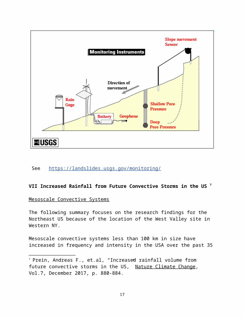
Real-Time Monitoring is being employed to learn more about initiating factors for these types of events. This monitoring is certainly something that the Agencies might want to consider on the steep slopes at West Valley.
See https://landslides.usgs.gov/monitoring/
VII Increased Rainfall from Future Convective Storms in the US 7
Mesoscale Convective Systems
The following summary focuses on the research findings for the Northeast US because of the location of the West Valley site in Western NY.
7 Prein, Andreas F., et.al, “Increased rainfall volume from future convective storms in the US,” Nature Climate Change, Vol.7, December 2017, p. 880-884.
12
Mesoscale convective systems less than 100 km in size have increased in frequency and intensity in the USA over the past 35 years causing fatalities and economic losses. Unfortunately, Traditional climate models hamper understanding of them and relevant changes to MCSs in the future. Authors work finds that intense summertime MCS frequency will more than triple in North America. The combined effect of 15-40% increase in maximum precipitation rates and a significant spreading of regions impacted by heavy precipitation results in up to 80% increases in the total MCS precipitation volume, focused in a 40 km radius around the storm center. These typically neglected increases substantially raise future flood risk. Findings need to be taken into account to improve climate adaptation efforts. (Both direct quotes and paraphrasing used in this summary.)
Economic losses from MCSs are increasing and currently exceed $20 Billion annually in the USA. Many of these losses are caused by MCSs that produce flash floods, debris flows, landslides, high winds and hail. Flash floods cause the highest fatalities per year other than heat. Extreme daily precipitation has increased in all regions of the US from 1958-2012. Authors used both a model that addresses MCSs and a storm-tracking algorithm to investigate climate change effects in the future during the months of June, July and August.
In the central US, MCSs with maximum precipitation of less than 40 mm per hour (1.57 inches per hr.) decrease by 30%, but extreme MCSs with maximum precipitation of more than 90 mm per hour (3.54 inches per hr.) increase by 380%. The highest relative increases in MCS frequency occur in Canada and the US Northeast where MCSs with maximum precipitation of greater than 80 mm per hour (3.15 inches per hr.) are almost unrepresented currently but become frequent in the future.
The factors that are important in these mesoscale systems are frequency, rainfall amounts, and size. Total precipitation volume hourly (P total) increases with the square of the distance from where the hourly maximum precipitation falls. (P max) Higher P max and a larger MCS results in a significant increase in the hourly total rainfall. The future predictions indicate that the mid to high latitudes will experience hourly total rainfalls for MCSs that are 20-40% increased. Note: Slow motion can be a characteristic of these storms, however this is not found in the Northeast.
They provide NY City as an example, because total rainfall increases are largest on a scale of major cities. The increase in total rainfall is expected to be 60%, which is roughly equivalent to adding 6 times the Hudson River discharge to an extreme MCS in the current climate. Authors assign the rainfall increase – 1/3 to a larger precipitation maximum and 2/3 to a larger size MCS.
In Western NY we have a different situation—extreme rainfall is problematic in riverine communities, where large drainage areas deliver rainfall to narrow rivers and valleys. Where there is no outlet for the water to spread out to a floodplain, water quantity increases and also moves faster, often scouring valley walls. This is what occurred in 2009 leading to a landslide removing 15 feet of the South Plateau and moving the valley wall closer the State Disposal Area.
Note reference to NOAA hazardous statistics: 74 year List of Severe Weather Fatalities, Footnote #6 from the article
13

An article from the same issue of Nature Climate change adds the following facts. 8
Mesoscale convection systems are the largest type of intense thunderstorms on Earth ranging in size from 100 to several hundred kilometers. These storms produce well over half of the spring and summer rainfall in the central US and comprise the majority of extreme rainfall events with a 100 year return period.
VIII Future Climate Risk from Compound Events9
In this article authors shift their focus from traditional risk assessment methods where one driver or hazard is studied at a time, potentially leading to an underestimation of risk. Instead they examine compound events where interacting processes can result in extreme events. They believe focusing on compound events associated with climate change can provide important information for planning around climate adaptation.
Examples: In the summer of 2010, Russia experienced a heat wave. Below-normal precipitation for the first seven months of the year induced a summer drought—exacerbating the heatwave. The dry and hot conditions led to widespread wildfires, which also resulted in large-scale air pollution, adding to deaths from the heat. The combination of these multiple dependent hazards caused devastating impacts, well beyond that caused by any single hazard in isolation. Farther afield the destruction of Russian crops led to an export ban, raising global wheat prices and contributing to instability and uprising in Egypt. Parallel to the Russian heatwave, Pakistan experienced a record-breaking flood that affected 20 million people. There is strong evidence that these events were connected through atmospheric dynamics.
Two additional examples were Hurricane Sandy in 2012 and Hurricane Harvey in 2017. While it might be assumed that these events have a low probability in the future, accounting for dependencies between all climate drivers and /or hazards may make such events foreseeable and predictable.
“Multiple drivers, conditional dependencies, a complex chain of processes and extreme return times; these are all characteristics of extreme climate events that lead to devastating impacts.” Unfortunately most previous climate-related studies of hazards focus on single drivers, and given the evidence that events that are particularly worrisome are multivariate in nature, the authors argue that a paradigm shift is needed to incorporate compound events in climate impact analysis. If this shift does not occur risks of catastrophic impacts will be underestimated. Bottom-up approaches are recommended for the paradigm shift rather than top-down or system-centric approaches.
8 Feng, Zhe, “Near doubling of storm rainfall,” Nature Climate Change, Vol.7, December 2017, p.855-856.
9 Zscheischler, Jakob, et.al, “Future climate risk from compound events,” Nature Climate Change, published online May 14, 2018. The article is the result of a workshop.
14
A helpful chart of definitions is provided including:
Risk – probability of events or trends x consequences -- where consequences are a function of the intensity of hazard (event or trend), exposure and vulnerability.
Previously we have commented on multiple interacting factors that could spell disaster at West Valley, these include:
Siting factors that West Valley violates: stability, sole source aquifer, groundwater discharge to surface water
Vulnerabilities- erosion, landslides, steep slopes, wetlands, streams, climate change impacts, earthquakes
Engineered features- earthen dams
We talked about these factors as additive or synergistic. This article is talking about compound events in contrast to hazards that look at only single drivers.The analysis of climate change is complex, but it must be done. It forms a significant part of the science basis for final decisions related to the nuclear waste facilities.
IX Empirical knowledge versus theoretical approach
Increasingly in modern times scientists and engineers are fascinated by new tools that help us measure and better understand the real world. Unfortunately, this fascination with theories and new models can lead us away from ensuring that the work is adequately grounded.
We found two passages from a 2010 Nuclear Waste Technical Review Board report that help to clarify this issue.10 Notably the Board’s findings ( on an unrelated issue) stressed the need for more research and an inspection program to collect real observational data. They rejected modeling data that relied on results not relevant to the issue under study.
It is critical that Models used and modelling done for West Valley be completely transparent about how the analyses was constructed, including all the inputs and assumptions, so that scientists can judge the value of the results.
“With respect to an engineering problem that is inherently uncertain, there are two fundamentally different approaches that may be employed to address the uncertainty: 1) the empirical/extrapolation/observational path and 2) the theoretical/modeling/validation path. An empirical approach is a traditional engineering method, especially in civil engineering. Observations are made and collected, that are then applied to a subject area such as concrete deterioration. In searching to understand patterns in the observations, empirical relationships are developed and may be extrapolated. Subsequent observations alert the engineer for the need to adjust the empirical relationships or initiate corrective action. A clear theoretical understanding
10 US Nuclear Waste Technical Review Board, Evaluation of the Technical Basis for Extended Dry Storage and Transportation of Used Nuclear Fuel, Dec. 2010.
15
of the phenomena involved is not necessary, though it is helpful. On the other hand, the theoretical approach requires sufficient knowledge of significant physical processes, appropriate conceptual models, and boundary condition values in order for an engineer to be able to quantitatively predict what will happen. Scientists and engineers are sometimes more confident in their predictions than the subsequent results would indicate, and for this reason validation exercises are necessary. Decision-makers may elect to use a combination of these two paths. The choice of approach will determine what data and informational needs are required, and what kind of observation activities and research are important to support and fund.” P. 114, 2nd para
“The long record of engineering applications has demonstrated that scientific and engineering applications of theoretical modeling or empirical knowledge to predict future behavior often are not sufficient. It is important that conceptual knowledge and supporting assumptions be validated with actual observational knowledge, to the extent possible. Because of incomplete knowledge, assumptions made, limited data, simplified models of nature, and overconfidence, it is essential that all important assumptions and conceptual models underlying predictions be validated to justify confidence in the predictions.” P.124
X Transparency related to Modelling used in the SEIS.
All inputs, parameters and variables should be explicitly listed and discussed in a stepwise manner so that the basic methodology is easily understood. A public audience should be used in order to identify logical questions and make any adjustments that are needed for the methods and inputs to be clear. Expert opinion is not sufficient –factual sources must be documented along with rationale.
We support Ray Vaughan’s recommendation for a workshop presentation and meeting with experts who can address the issue of uncertainty and appropriate development of variables for the models used.
XI Erosion Modeling
The erosion work suffers from a serious lack of transparency. Members with a science background, but not in erosion are severely constrained in understanding this work.
a) The Major goal or objective of this work should have been analyzing the potential the loss of radiological containment. An extraordinary amount of work was devoted elsewhere to the detriment of answering the most important question.
b) All six erosion analysis site for the SDA appear to be located on the geomembrane cover. Your study identified plateau rims as most vulnerable. Yet none of the selected sites were located in the 6 gullies located on the northwest or northeast of the SDA or on the rim, but outside of the reach of the cover material. Given that the cover would be maintained in the near term, how exactly was erosion modeled? How was rainfall and runoff handled in the erosion model to account for less rainfall on the cover and more rain falling elsewhere as runoff?
16
c) It seems that the actual erosion modeling results are nowhere near the downcutting observed over 13,000 years.
“Geomorphic analysis and age dating by the Erosion Working Group suggests that But-termilk Creek and its tributaries cut their present-day valleys sincethe last glacial retreat, which appears to have occurred approximately 13,000 years ago(Wilson and Young, 2018). The average rate of postglacial downcutting on ButtermilkCreek, at roughly 13 feet (4 meters) per thousand years, was rapid by global standards(see, for example, review of landscape evolution studies by Tucker (2015)). If similarlyrapid rates of stream and gully erosion continue into the future, then it is reasonable toconclude that landscape evolution in and around the site over the coming millennia mayinvolve substantial changes in the terrain itself, possibly leading to the release of radiological and/or toxic materials.” p. 32 of EWG modelling report:
Four thousand meters of downcutting in 13,000 years but only a few feet at the S. Plateau in 10,000 years? (This requires reading maps with colored areas and no specific num-bers.) This finding is questionable. It appears to indicate a major problem with the model. Note we should have some actual measurements of erosive changes from the net-work installed at the WV site. The empirical data should be used to fix the model. By keeping good records, we should be able to use real WV data in the future following an extreme rainfall or other event.
d) Thirty-seven erosion long- term erosion models were used. The main experiment in-volved 8200 model evaluations and the second involved 16,000 evaluations. This looks like system overload. More doesn’t necessarily mean more thorough work. How many of these models have been validated for predictive erosion modeling out to 10,000 years? We are not aware of any predictive model for the long- term associated with geological processes—erosion, landslides, earthquakes.
e) The EWG does mention that landslides were not considered in this modeling and said a geotechnical expert would need to examine this issue. Landslides could impact topography and subsequent erosion. However, a landslide resulted from a raging Buttermilk Creek in Aug. 2009--- how was the power of this stream evaluated for its potential future impact related to hillside erosion or landsliding? Since water flow was the primary component of erosion modeling this should have been examined. See Ray Vaughan’s observations & pictures of this landslide in Appendix.
f) Rainfall, particularly since extreme rainfall will be increasing associated with climate change, needs to be directly represented in the model rather than subsumed as an erodibility factor.
g) Models need to be fully transparent for the public. We cannot have trust in black boxes in which we cannot fathom what was done and how.
h) We also cannot understand how PPA contractors are supposed to work with this model or is it a model? or is it 37 models x 16,000 evaluation methods?
17
i) This erosion model and any other models used at the site must be able to adequately capture the real changes in weather extremes expected with climate changes including mesoscale convection systems and compound events, discussed earlier in these comments. Extreme rainfall has more erosive force than merely increasing average rainfalls. Was wind & rain included in the erosion model?
Finally, we support the detailed comments on the Erosion Modeling provided by Ray Vaughan.
Thank you for your attention.
Respectfully submitted,
Barbara J. WarrenExecutive Director
Enclosure: Appendix
18
Appendix
Summary of West Valley site landslide and associated stormRay Vaughan 8/20/09
A large landslide occurred on the West Valley nuclear site following heavy rain on August 9-10,2009. The slide was on the west bank of Buttermilk Creek at a location where slumping has beenan ongoing problem. The top of the steep bank at this location is about 160 feet above the levelof Buttermilk Creek (roughly the same height as Niagara Falls), and a strip of land about 15 feetwide has been lost from the top of the bank. The strip of land, broken into several pieces, slidonly partway down the slope, and the grass and trees on the strip of land are still largely intact but displaced downward many feet from the top of the bank where they had been growing. Based on past experience at this loca-tion, the grass, trees, and their platforms of earth will continue to slide down-ward at an irregular pace during the upcoming weeks and months, and they will eventually be washed away by the creek.
This strip of land at the top of the bank slid downward after the layers of earth beneath itcollapsed and tumbled down the steep slope as a result of the rainfall. At this location, theunderlying layers included a thick gray clayey layer of Lavery Till (perhaps fifty feet thick at thislocation), and a sandy-gravelly “Kent Recessional” layer beneath the Lavery Till. The collapsewas apparently triggered by heavy rain in same general manner seen at many other landslides,where a rain-swollen creek undercuts the base or “toe” of a hillslope, remov-ing part of thesupport for the upper part of the slope. At the same time, groundwater seep-age through theupper part of the slope tends to increase during heavy rain, loosening and/or lubricating blocks oftill and other layers that form the steep slope. Sometimes the end result is simply a slowdownward slumping or sliding, but it appears that a large portion of the But-termilk Creek bankgave way suddenly in this event, causing a large quantity of Lavery Till to break into irregular
19

blocks that tumbled down toward (and partly into) the creek, accompanied by quantities of theless cohesive Kent Recessional sediments. In all, thousands of tons of Lavery Till, KentRecessional, etc., were involved in this landslide. Most of this material 1 re-mains in a jumbled pile of irregular blocks at the base of the slope. Based on past experience, it will be washed away by the creek over a period of weeks or months.
The August 9th-10th rainfall that triggered this landslide also caused onsite reservoirs to overflow and was responsible for extensive offsite damage, es-pecially in the village of Gowanda which is located further downstream in the Cattaraugus Creek watershed. One resident of Gowanda drowned when swept into the raging floodwaters. Despite the clear evidence of massive flooding and erosion within the Cattaraugus Creek watershed, there is no ac-curate record of the amount of rain that fell. A rain gauge that normally oper-ates at the West Valley site was inoperative for part of the storm due to power outages and a lack of reliable connection1“Thousands of tons” is a conservative estimate of the amount of material that fell in thislandslide. The estimate is based on a bank height of 160 feet and a loss of 15 feet of bank at thetop (either continuing downward as a 15-foot-thick “slice” or tapering to zero thickness at thebase of the slope), and extending for at least 100 feet along the top of the bank. Any suchvolume is at least 100,000 ft3 and weighs at least several thousand tons.
to the site’s emergency backup generators. Rain gauges in other locations (e.g., Buffalo, Dunkirk, Eden) were outside the area of heaviest rainfall. The total rainfall during the two-day event appears to have been about 5 inches, when averaged over the entire 436 mi2 watershed area of Cattaraugus Creek upstream from Gowanda.2 Some parts of the Cattaraugus Creek basin pre-sumably received less than 5 inches while other parts received more, but in the absence of data the 5-inch basinwide average is probably the best esti-mate that can be assigned to the West Valley site for this rainfall event.
A 5-inch rainfall, while clearly devastating, falls far short of larger rainfall events that haveoccurred elsewhere in New York and Pennsylvania under current climatic conditions.3 However,current conditions should not be considered a reliable guide for the future, as larger and morefrequent rainfall events are an expected consequence of climate change.4 Thus, even though therecent 5-inch storm produced clearly observable effects such as landsliding and erosion at theWest Valley site, not only along Buttermilk Creek but in other onsite creeks such as Erdman
20

Brook, Franks Creek, and Quarry Creek,5 the disproportionately larger effects of larger stormsneed to be assessed and addressed. Due to its steep topography, erodible soils, and pervasiveslumping and landsliding, the site is ill-prepared to deal with a larger rainfall such as 10 inches,and it is not clear that engineered barriers can deal with the effects. Climate change will aggravate the problem by delivering even larger, more frequent storms, causing the site to unravel at an even faster rate.2Estimate by Raymond C. Vaughan, Ph.D., based on integration of the flow recorded athalf-hour intervals at the USGS stream gage on Cattaraugus Creek in Gowanda and based on anassumed basinwide runoff/precipitation ratio of 0.6. The latter ratio is based approx-imately onRandall, USGS Open-File Report 96-395.3For example, as described by Knuepfer, GSA 2007 Northeastern Section presenta-tion,“Binghamton, NY, and surrounding areas experienced a flood of historic proportions June 27-July 1, 2006 due to heavy rains (up to 13-15 inches over 4 days in some lo-cations) superimposed on moderately saturated soils.”4For example, see T.R. Karl et al., Weather and Climate Extremes in a Changing Cli-mate,U.S. Climate Change Science Program, Synthesis and Assessment Product 3.3, June 2008, onlineat www.climatescience.gov/Library/sap/sap3-3/final-report/sap3-3-final-all.pdf.5 Observations by Vaughan, August 19, 2009.
Photos Below
21
22

23