€¦ · web viewppt parts per thousand. ... which appears in the swrcb's may 1995 wqcp, is...
TRANSCRIPT

WATER QUALITY CONTROL PLANfor the
San Francisco Bay/Sacramento-San Joaquin
Delta Estuary
MAY 1995
STATE WATER RESOURCES CONTROL BOARDCALIFORNIA ENVIRONMENTAL PROTECTION AGENCY

STATE WATER RESOURCES CONTROL BOARDRESOLUTION NO. 95-24
ADOPTION OF THE WATER QUALITY CONTROL PLANFOR THE
SAN FRANCISCO BAY/SACRAMENTO-SAN JOAQUIN DELTA ESTUARY
WHEREAS:
1. The State Water Resources Control Board (SWRCB) is responsible for the regulation of activities and factors which may affect the quality of the waters of the state. (Wat. Code §§ 13000, 13001.)
2. The SWRCB has undertaken a proceeding under its water quality authority at Water Code section 13000 et seq. to establish a water quality control plan that will supersede (1) the Water Quality Control Plan for Salinity for the San Francisco Bay/Sacramento-San Joaquin Delta Estuary adopted May 1991 (1991 Plan) in SWRCB Resolution No. 91-34 and (2) the Water Quality Control Plan for the Sacramento-San Joaquin Delta and Suisun Marsh, adopted August 1978 in SWRCB Resolution No. 78-43.
3. The SWRCB commenced this proceeding on March 25, 1994 by issuing a notice of a series of public workshops to review the existing standards for the San Francisco Bay/Sacramento-San Joaquin Delta Estuary (Bay-Delta Estuary). The SWRCB held six public workshops in April through October 1994 and the SWRCB staff held three additional public workshops in September and October 1994. Notice of all workshops was sent to all parties who indicated an interest in receiving notice.
4. During the workshops, the SWRCB urged the interested parties to develop alternatives for revising the previous water quality objectives for the Bay-Delta Estuary. The Department of Fish and Game, Bay Institute of San Francisco, Delta Wetlands and United States Environmental Protection Agency developed proposals for the SWRCB to consider. The SWRCB evaluated these alternatives in its environmental review for the development of a draft Bay-Delta plan. After negotiations, a number of parties reached an agreed-upon recommendation to the SWRCB for changes in the Bay-Delta water quality objectives. This agreement is called the "Principles for Agreement" and was signed on behalf of numerous interest groups and governmental agencies on December 15, 1994. The SWRCB used several elements of this agreement (with some modifications) and the

other recommendations from interested parties in preparing the draft plan.
5. The SWRCB released the first draft of the Water Quality Control Plan for the San Francisco Bay/Sacramento-San Joaquin Delta Estuary (Bay-Delta Plan) for public review and comment on December 15, 1994. On January 3, 1995, the SWRCB issued a notice of public hearing for consideration of the plan, in accordance with state and federal requirements. The notice was sent to all interested parties and was published. On January 24, 1995, the SWRCB released a draft environmental report appendix to the draft Bay-Delta Plan. The SWRCB held the public hearing on February 23, 1995. The comment period for the draft Bay-Delta Plan and the appended Environmental Report closed March 10, 1995.
6. The Bay-Delta Plan will protect the same beneficial uses that were protected by the 1991 Plan. The definitions of the beneficial uses, however, have been changed nonsubstantively to ensure consistency with the SWRCB's current policy and uniform direction to the Regional Water Quality Control Boards.
The water quality objectives for municipal and industrial beneficial uses and for agricultural beneficial uses are unchanged from the 1991 Plan except that the effective date of the agricultural salinity objectives for the southern Delta stations on the Old River has been extended from January 1, 1996 to December 31, 1997.
The objectives for fish and wildlife beneficial uses for salinity and temperature in the 1991 Plan, and the flow and operational objectives in the 1978 Plan that were not superseded by the 1991 Plan have been replaced with a complete new set of objectives for fish and wildlife.
7. The SWRCB has considered all the oral and written comments that were submitted and, in accordance with the SWRCB's regulations (23 Cal. Code Regs. § 3779), has prepared responses to the comments containing significant environmental points as well as responding to other comments.
8. The portions of the Bay-Delta Plan consisting of the Water Quality Control Plan for the San Francisco Bay/Sacramento-San Joaquin Delta Estuary and the appended Environmental Report, have been revised in response to the comments received from the interested parties and the Responses to Comments has been added as a second appendix.
3.

9. The Bay-Delta Plan will be reviewed periodically in compliance with Water Code section 13240 and federal Clean Water Act section 303(c) (33 U.S.C. § 1313(c)).
10.The Bay-Delta Plan supplements the other water quality control plans that cover the Bay-Delta Estuary; together they include all necessary elements of water quality control plans in accordance with Water Code sections 13241 and 13242 and federal requirements.
11. In compliance with the California Environmental Quality Act, the SWRCB has prepared the Bay-Delta Plan under a program certified under Public Resources Code section 21080.5 as a substitute document for an environmental impact report or a negative declaration. The SWRCB has reviewed the Environmental Report which is appended to the Bay-Delta Plan and has considered the information in it.
12.Appendix I of the Bay-Delta Plan, at Chapter XIV, identifies significant or potentially significant environmental effects that may or will occur if the Bay-Delta Plan is implemented, and makes findings with respect to the measures that may be used to mitigate any significant environmental effects of implementation. Those findings are incorporated herein by reference. (See Pub. Res. Code §§ 21080.5(d)(2)(i) and 21081, 14 Cal. Code Regs. §§ 15091 and 15093, and 23 Cal. Code Regs. § 3780.)
13.Newly adopted water quality standards and water quality standards that have been revised after a periodic review are to be submitted to the United States Environmental Protection Agency (U.S. EPA) for approval. Other portions of water quality control plans, such as the program of implementation are to be submitted to U.S. EPA as part of the continuing planning process but do not require approval. The SWRCB does not concede that it is required under the federal Clean Water Act to submit all parts of this plan to the U.S. EPA for approval. In the view of the SWRCB, the objectives for flow and operations are not subject to U.S. EPA approval, although the SWRCB recognizes that the U.S. EPA may disagree.
THEREFORE BE IT RESOLVED:
1. That the SWRCB adopts the Bay-Delta Plan in accordance with Water Code section 13170, including the appended Environmental Report and the Responses to Comments.
4.

2. That the Executive Director is directed to forward the Bay-Delta Plan to the U.S. EPA for review and approval in accordance with requirements of the federal Clean Water Act (33 U.S.C. § 1251 et seq.).
CERTIFICATION
The undersigned, Administrative Assistant to the Board, does hereby certify that the foregoing is a full, true, and correct copy of a resolution duly and regularly adopted at a meeting of the State Water Resources Control Board held on May 22, 1995.
AYE: John P. CaffreyMary Jane ForsterMarc Del PieroJames M. StubchaerJohn W. Brown
NO: None
ABSENT: None
ABSTAIN: None
/s/ Walt Pettit, for Maureen Marché
Administrative Assistant to the Board
5.

TABLE OF CONTENTS
PageList of Figures........................................................................................iiList of Tables.........................................................................................iiList of Abbreviations................................................................................iiiList of Acronyms....................................................................................iiiChapter I. Introduction............................................................................ 1
A. Purpose and Scope..................................................................... 3B. Background.............................................................................. 4C. Legal Authority........................................................................ 7
Chapter II. Beneficial Uses.......................................................................12Chapter III. Water Quality Objectives..........................................................14
A. Water Quality Objectives for Municipal and IndustrialBeneficial Uses.....................................................................14
B. Water Quality Objectives for Agricultural Beneficial Uses....................14
C. Water Quality Objectives for Fish and Wildlife Beneficial Uses..............14Chapter IV. Program of Implementation.......................................................27
A. Implementation Measures Within SWRCB Authority OverWater Diversion and Use.........................................................27
B. Implementation Measures Requiring SWRCB Water Quality andWater Rights Authority and Multi-Agency
Cooperation....................28C. Recommendations to Improve Habitat
Conditions...............................33D. Monitoring and Special Studies Program..........................................41
i.
iii

Appendix 1: Environmental Report, Appendix 1 to Water Quality Control Plan for the San Francisco Bay/Sacramento-San Joaquin Delta Estuary (bound separately)
Appendix 2: Response to Comments, Appendix 2 to Water Quality Control Plan for the San Francisco Bay/Sacramento-San Joaquin Delta Estuary (bound separately)
ii.
iii

LIST OF FIGURES
Figure Page
1Bay-Delta Estuary..................................................................2
2Bay-Delta Estuary Monitoring Stations........................................45
LIST OF TABLES
Table Page
1 Water Quality Objectives for Municipal and IndustrialBeneficial Uses.....................................................................16
2 Water Quality Objectives for Agricultural Beneficial Uses................17
3 Water Quality Objectives for Fish and WildlifeBeneficial Uses.....................................................................18
4 Water Quality Compliance and Baseline Monitoring........................43
iii.
iii
LIST OF ABBREVIATIONS
BODbiochemical oxygen demandcfs cubic feet per secondDO dissolved oxygenEC electrical conductivityMAFmillion acre-feetmg/l milligram(s) per litermmhos/cm millimhos per centimeterNDOI Net Delta Outflow Indexppt parts per thousandTAF thousand acre-feet
LIST OF ACRONYMS
CVP Central Valley ProjectCVPIA Central Valley Project Improvement ActDFA California Department of Food and AgricultureDFGCalifornia Department of Fish and GameDWR California Department of Water ResourcesFED Federal Ecosystem DirectorateFERC Federal Energy Regulatory CommissionIEP Interagency Ecological ProgramMOU Memorandum of UnderstandingNMFS National Marine Fisheries ServiceNRCS U.S. Natural Resources Conservation Service (formerly Soil Conservation Service)RWQCB Regional Water Quality Control BoardSDWA South Delta Water AgencySJVDP San Joaquin Valley Drainage ProgramSMPA Suisun Marsh Preservation AgreementSRCD Suisun Resource Conservation DistrictSWPState Water ProjectSWRCB State Water Resources Control BoardUSBR U.S. Bureau of ReclamationUSEPA U.S. Environmental Protection AgencyUSFWS U.S. Fish and Wildlife ServiceUSGS U.S. Geological Survey
iv.
iii
BAY-DELTA PLAN
Water Quality Control Plan for theSan Francisco Bay/Sacramento-San Joaquin Delta Estuary
CHAPTER I. INTRODUCTION
The San Francisco Bay/Sacramento-San Joaquin Delta Estuary (Bay-Delta Estuary or Estuary) (Figure 1) is important to the natural environment and economy of California. The watershed of the Bay-Delta Estuary provides drinking water to two-thirds of the State's population and water for a multitude of other urban uses, and it supplies some of the State's most productive agricultural areas, both inside and outside of the Estuary. The Bay-Delta Estuary itself is one of the largest ecosystems for fish and wildlife habitat and production in the United States. However, historical and current human activities (e.g., water development, land use, wastewater discharges, introduced species, and harvesting), exacerbated by variations in natural conditions, have degraded the beneficial uses of the Bay-Delta Estuary, as evidenced by the declines in the populations of many biological resources of the Estuary.
The State Water Resources Control Board (SWRCB) has previously adopted water quality control plans and policies to protect the water quality and to control the water resources which affect the beneficial uses of the Bay-Delta Estuary. These plans and policies have been adopted consistent with section 13000 et seq. of Division 7 of the California Water Code (Stats. 1969, Chapter 482) and pursuant to the authority contained in section 13170 (Stats. 1971, Chapter 1288). This plan supersedes both the Water Quality Control Plan for the Sacramento-San Joaquin Delta and Suisun Marsh, adopted August 1978 (1978 Delta Plan), and the Water Quality Control Plan for Salinity for the San Francisco Bay/Sacramento-San Joaquin Delta, adopted May 1991 (1991 Bay-Delta Plan). The SWRCB will review this plan every three years to ensure that it adequately protects beneficial uses. The SWRCB will implement this plan principally through the adoption of a water right decision.
Documentation of the SWRCB's considerations in developing this water quality control plan is contained in the appendix titled "Environmental Report, Appendix 1 to Water Quality Control Plan for the San Francisco Bay/Sacramento-San Joaquin Delta Estuary". SWRCB responses to
1.
26

comments received in conjunction with the public hearing on this plan is contained in the appendix titled "Response to Comments, Appendix 2 to Water Quality Control Plan for the San Francisco Bay/Sacramento-San Joaquin Delta Estuary".
2.
26

Figure 1, Bay-Delta Estuary, which appears in the SWRCB's May 1995 WQCP, is a graphic not compatible with this word processing program, and, thus, cannot be shown here.
3.
26

A. Purpose and Scope
The purpose of this plan is to establish water quality control measures which contribute to the protection of beneficial uses in the Bay-Delta Estuary. Like all water quality control plans, this plan consists of: (1) beneficial uses to be protected; (2) water quality objectives for the reasonable protection of beneficial uses; and (3) a program of implementation for achieving the water quality objectives. Together, the beneficial uses and the water quality objectives established to protect them are called water quality standards under the terminology of the federal Clean Water Act.
This plan provides the component of a comprehensive management package for the protection of the Estuary's beneficial uses that involves salinity (from saltwater intrusion and agricultural drainage) and water project operations (flows and diversions), as well as a dissolved oxygen objective. This plan supplements other water quality control plans adopted by the SWRCB and regional water quality control boards (RWQCBs), and State policies for water quality control adopted by the SWRCB, relevant to the Bay-Delta Estuary watershed. These other plans and policies establish water quality standards and requirements for parameters such as toxic chemicals, bacterial contamination, and other factors which have the potential to impair beneficial uses or cause nuisance.
Water quality control policies and plans relevant to the protection of beneficial uses of the Bay-Delta Estuary include: (1) Statement of Policy With Respect to Maintaining High Quality Waters in California (SWRCB Resolution No. 68-16); (2) State Policy for Water Quality Control (adopted by motion on July 6, 1972); (3) Water Quality Control Policy for Enclosed Bays and Estuaries (SWRCB Resolution No. 74-43); (4) Water Quality Control Policy on the Use and Disposal of Inland Waters Used for Power Plant Cooling (SWRCB Resolution No. 75-58); (5) Water Quality Control Plan for Control of Temperature in the Coastal and Interstate Waters and Enclosed Bays and Estuaries of California (adopted by the SWRCB on September 18, 1975); (6) Policy With Respect to Water Reclamation in California (SWRCB Resolution No. 77-1); (7) Sources of Drinking Water Policy (SWRCB Resolution No. 88-63); (8) Pollutant Policy Document for the San Francisco Bay/Sacramento-San Joaquin Delta (SWRCB Resolution No. 90-67); (9) Water Quality Control Plan, San Francisco Bay Basin (including future changes to this plan as the changes take effect); and (10) Water Quality Control Plans, Central Valley Basin (including future changes to these plans as the changes take effect).
This plan establishes water quality objectives that will ensure reasonable protection of the beneficial uses and will prevent nuisance. It also recommends other controls. Overall, this document provides planning for
4.
26

reasonable controls on the factors which have been identified as likely contributors to the declines in aquatic resources in the Bay-Delta Estuary. Consistent with the intent of the State Legislature, as expressed in the Porter-Cologne Water Quality Control Act of 1969, as amended (Porter-Cologne Act) (Wat. Code §13000 et seq.), these objectives and recommendations are intended to attain the goal of the highest water quality which is reasonable, considering all demands being made and to be made on those waters and the total values involved, beneficial and detrimental, economic and social, tangible and intangible. Reasonably foreseeable effects of implementation of this plan are evaluated in the environmental report appended to this plan. Other effects of implementation must be evaluated as the precise measures to implement this plan are developed.
This plan, in conjunction with RWQCB plans, other SWRCB plans and policies, and programs under the jurisdictions of other agencies, such as the Central Valley Project Improvement Act (CVPIA), provides a coordinated and comprehensive ecosystem approach to protection of the beneficial uses of the Bay-Delta Estuary.
Most of the objectives in this plan will be implemented by assigning responsibilities to water rights holders because the factors to be controlled are primarily related to flows and diversions. This plan, however, is not to be construed as establishing the responsibilities of water rights holders. Nor is this plan to be construed as establishing the quantities of water that any particular water rights holder or group of water rights holders may be required to release or forego to meet objectives in this plan. The SWRCB will consider, in a future water rights proceeding or proceedings, the nature and extent of water rights holders' responsibilities to meet these objectives. Water Code section 1258 charges the SWRCB, when it acts on water appropriations, to consider water quality control plans, and it authorizes the SWRCB to subject the appropriations to terms and conditions that are necessary to carry out the plans. It does not, however, impair the SWRCB's discretion to decide whether to impose such conditions or the conditions to be imposed. If necessary after the water rights proceeding, this plan could be amended to reflect any changes that may be needed to ensure consistency between the plan and the water right decision.
B. Background
Regulation of the Bay-Delta Estuary has occurred through the adoption of water right decisions, water quality control policies, and water quality control plans. A brief summary of the principal decisions, policies, and plans relevant to the Estuary is provided below.
5.
26
In February 1961, the State Water Rights Board (predecessor to the SWRCB) adopted Water Right Decision 990, which approved water rights for the federal Central Valley Project (CVP). The Board did not attach specific water quality standards as terms and conditions of the CVP permits; however, it did reserve jurisdiction to impose such requirements in the future.
The development of water quality standards for the Sacramento-San Joaquin Delta (Delta) began with the adoption of agricultural salinity standards as terms and conditions of Water Right Decision 1275, which approved water rights for the State Water Project (SWP) in May 1967. In response to the concern by the Secretary of the Interior that existing standards for the Delta did not adequately protect municipal, industrial, agricultural, and fishery uses, the SWRCB (newly created by the amalgamation of the State Water Rights Board and the State Water Quality Control Board) adopted a water quality control policy for the Delta through Resolution 68-17 in 1968. This policy supplemented a water quality control policy for the Delta that was developed by the Central Valley RWQCB and adopted by the SWRCB in June 1967. In accordance with a commitment made in Resolution 68-17 to supplement the salinity standards, the SWRCB adopted Water Right Decision 1379 (D-1379) in July 1971. D-1379, which required the CVP and the SWP to meet standards for non-consumptive fish and wildlife uses in addition to agricultural, municipal, and industrial consumptive uses, was stayed by action of the court in October 1971 as a result of litigation.
In 1971, the RWQCBs adopted, and the SWRCB approved, interim water quality control plans for the 16 planning basins in the State, including the Delta and Suisun Marsh. These regional water quality control plans marked the completion of the first phase of a comprehensive statewide planning effort. Subsequently, long-term standards for the Delta and Suisun Marsh were established in the regional plans for the Sacramento-San Joaquin Delta Basin and the San Francisco Bay Basin, which were approved by the SWRCB in 1975 and 1976, respectively. Meanwhile, in April 1973, the SWRCB adopted a water quality control plan, through Resolution 73-16, which supplemented the State water quality control policies for the Delta.
In August 1978, the SWRCB exercised its reservation of jurisdiction over the water right permits for the CVP and the SWP by adopting Water Right Decision 1485 (D-1485). At the same time, the SWRCB adopted the 1978 Delta Plan. Together, the 1978 Delta Plan and D-1485 revised existing standards for flow and salinity in the Delta's channels and ordered the Bureau of Reclamation (USBR) and the Department of Water Resources (DWR) to meet these standards by either reducing pumping, or releasing water stored in upstream reservoirs, or both. To address the continuing uncertainty associated with possible future project facilities and the need for
6.
26

additional information on the Estuary's ecosystem, the SWRCB committed to review the 1978 Delta Plan in 10 years.
In July 1987, the SWRCB began proceedings to reexamine water quality objectives for the Bay-Delta Estuary and consider how water right permits would be modified to meet the new objectives. In May 1991, the SWRCB adopted the 1991 Bay-Delta Plan with objectives for salinity, dissolved oxygen, and temperature. The 1991 Bay-Delta Plan was subsequently submitted to the U.S. Environmental Protection Agency (USEPA) for approval. In September 1991, the USEPA approved all of the salinity objectives for municipal, industrial, and agricultural beneficial uses, and the dissolved oxygen objective for fish and wildlife beneficial uses. The USEPA stated that the other fish and wildlife objectives were disapproved because of their failure to protect estuarine habitat and other fish and wildlife beneficial uses. As required under federal regulations (40 CFR 131.22) when a state does not adopt changes in standards recommended by the USEPA upon notification of approval or disapproval of a state's standards, the USEPA initiated promulgation of water quality standards for the Bay-Delta Estuary. In January 1994, the USEPA published draft standards for the Estuary in the Federal Register (59 Fed. Reg. 813).
7.
26

To coordinate the parallel State and federal Bay-Delta resource management activities, the Governor's Water Policy Council of the State of California (Council) and the Federal Ecosystem Directorate (FED), comprised of State and federal resource agencies collectively known as CALFED, entered into a Framework Agreement in June 1994. The purpose of the agreement is to establish a comprehensive program for coordination and communication between the Council and the FED regarding environmental protection and water supply dependability in the Bay-Delta Estuary and its watershed. The CALFED agreement identifies three areas where both State and federal interests and responsibilities are interrelated, and coordination and cooperation are particularly important: (1) formulation of water quality standards for the Estuary; (2) improved coordination of federal and State water project operations with regulatory requirements; and (3) development of a long-term solution to fish and wildlife, water supply reliability, flood control, and water quality problems in the Bay-Delta Estuary. In accordance with the Framework Agreement, the administrator of the USEPA signed final federal standards for the Estuary on December 14, 1994 (published in January 1995 at 60 Fed. Reg. 4664)1.
Meanwhile, in March 1994, the SWRCB commenced proceedings to review the 1978 and 1991 Bay-Delta plans. A series of six SWRCB public workshops and three SWRCB staff workshop sessions were held from April through October 1994 to seek comments and recommendations regarding the content of a new water quality control plan for the Bay-Delta Estuary. Several issues were addressed at the workshops including: the selection of standards for review; level of protection; effects of Delta and upstream diversions on beneficial uses; causes of declines in aquatic resources; methods for analyzing water supply, environmental, economic, and social effects of proposed standards; Endangered Species Act issues; interim implementation of standards by the CVP and the SWP; and the technical bases for alternative sets of proposed standards submitted to the SWRCB during the proceedings. The SWRCB released the first draft of this plan on December 15, 1994 and subsequently released a draft Environmental Report, which is appended to the plan and documents the SWRCB's analysis of the needs for and the effects of implementing the plan, for public review.
In the workshops that preceded the December 15, 1994 draft of this plan, the SWRCB encouraged the parties to submit proposals for standards to be included in this plan. The SWRCB further encouraged the parties to
1 ? The preamble to the USEPA's December 15, 1993 proposed rule for Bay-Delta standards states that "it is EPA's longstanding policy that the federal regulations will be withdrawn if a State adopts and submits standards that in the Agency's judgment meet the requirements of the [Clean Water] Act." (59 Fed. Reg. 813, January 6, 1994). Also, the Principles for Agreement, discussed in this section, commits the USEPA to withdraw the federal standards when the SWRCB adopts a final plan consistent with the Principles for Agreement.
8.
26

negotiate agreements with other parties in which the parties would jointly recommend standards to the SWRCB for inclusion in this plan. These proposals are included in the discussion of alternative sets of standards in Chapter XI of the Environmental Report. They include the USEPA's September 1994 draft standards, a proposal submitted by the Department of Fish and Game (DFG), and the "Principles for Agreement on Bay-Delta Standards Between the State of California and the Federal Government" (Principles for Agreement). Only the Principles for Agreement, which was formulated by CALFED and representatives of several urban, agricultural, and environmental groups, is a broad-based agreement that represents most of the interest groups involved in the SWRCB's proceedings. On December 15, 1994, the participating interest groups signed the Principles for Agreement.
The Principles for Agreement, which is intended to be effective for three years, contains proposed Bay-Delta water quality objectives and outlines additional agreements regarding the federal Endangered Species Act, funding for non-flow related measures, and other institutional issues. This water quality control plan is based on the record compiled by the SWRCB during its proceedings and is consistent with the Principles for Agreement.
C. Legal Authority
1. General. The SWRCB has prepared this water quality control plan under the Porter-Cologne Act. The RWQCBs have the primary responsibility for formulating and adopting water quality control plans for their respective regions (Wat. Code §13240), but the SWRCB also is authorized, under Water Code section 13170, to adopt water quality control plans in accordance with the provisions of section 13240 et seq2. The SWRCB's authority includes, but is not limited to, waters for which water quality standards are required by the federal Clean Water Act. (Wat. Code §13170) When the SWRCB adopts a water quality control plan, it supersedes regional water quality control plans for the same waters to the extent of any conflict. (Wat. Code §13170) Before adopting a water quality control plan pursuant to section 13170, the SWRCB must consider all relevant management agency agreements which are intended to protect a specific beneficial use of water. (Wat. Code §13170.1)
Fundamentally, a water quality control plan consists of establishment, for the waters within a specified area, of the beneficial uses to be protected, water quality objectives, and a program of implementation. (Wat. Code §13050(j)) Components in this plan will, when implemented: (1) carry out provisions of the reasonable use doctrine (Cal. Const. Art. X, §2; Wat. Code 2 ? The SWRCB also has authority to adopt State policy for water quality control under Water Code section 13140.
9.
26

§§100, 275, and 1050); (2) protect public trust resources (See National Audubon Society v. Superior Court (1983) 33 Cal.3d 419, 189 Cal.Rptr. 346); and (3) carry out statutory principles pertaining to water rights (Wat. Code §§183, 1243, 1243.5, 1251, 1253, and 1256-1258). This plan addresses the interrelated fields of water quality and water supply and plans for their coordination. Because this plan will be implemented principally through changes in water rights, it necessarily plans for as-yet undetermined water rights changes that will accomplish its purposes.
This plan includes an environmental report prepared in compliance with Public Resources Code section 21080.5. As discussed in the Environmental Report in section B.3 of Chapter I, the SWRCB's basin planning program has been certified by the Secretary for Resources as meeting the requirements of Public Resources Code section 21080.5. (14 Cal. Code Regs. §15251(g)) Section 21080.5 authorizes State agencies acting under a certified program to assess the environmental effects of their actions within the decision-making document instead of in a separate environmental impact report or negative declaration.
The basin planning program under Water Code section 13000 et seq. includes not only the fundamental components of a water quality control plan but also other components, as needed, for carrying out the SWRCB's broad obligations and policies under the Porter-Cologne Act. The complete plan will, when implemented, affect water rights, water supply, pollutants that are discharged to the waters of the Bay-Delta Estuary, and activities of other agencies who will carry out recommendations in this plan.
A discussion of the legal authority pertaining to each of the three fundamental components of a water quality control plan follows.
2. Beneficial Uses. A water quality control plan must establish beneficial uses. (Wat. Code §13050(j)) Beneficial uses serve as a basis for establishing water quality objectives. The beneficial uses to be protected were established in the 1978 Delta Plan and the 1991 Bay-Delta Plan. Since all of the beneficial uses exist and there were no requests for changes in the beneficial uses, these uses are carried over in this plan from the earlier plans. Their definitions, however, have been modified nonsubstantively to ensure consistency and uniformity with the use definitions in other plans.
3. Water Quality Objectives. A water quality control plan must contain such water quality objectives as are needed to ensure the reasonable protection of beneficial uses and the prevention of nuisance. (Wat. Code §13241) At the least, the SWRCB must consider, in establishing objectives, the beneficial uses, the environment of the hydrographic unit, the water quality that could be achieved, economic considerations, the need for
10.
26

housing, and the need to develop and use recycled water. (Wat. Code §13241)
The Central Valley and San Francisco Bay RWQCBs have adopted water quality objectives for many properties and characteristics of the Bay-Delta Estuary. In most cases, the SWRCB does not wish to supersede those objectives. Therefore, the SWRCB's Bay-Delta plans historically established or amended primarily objectives for which implementation includes regulation of water diversion and use3; i.e., situations in which water supply activities affect water quality. Until the SWRCB adopted the 1991 Bay-Delta Plan, the Bay-Delta plans contained objectives only for salinity, flow, and water project operations. This plan amends or carries over the objectives for salinity and dissolved oxygen in the 1991 Bay-Delta Plan, and includes objectives for flow and water project operations in the Bay-Delta Estuary.
The objectives for flow and water project operations amend objectives in the 1978 Delta Plan. The SWRCB did not amend these objectives in the 1991 Bay-Delta Plan, but it specifically retained the option of revising these objectives later. Although most water quality control plans do not regulate flow or water project operations, flow and water project operations are within the scope of objectives that can be adopted in a water quality control plan under the Porter-Cologne Act.
The State water quality law encompasses a broad scope of parameters that can be regulated using water quality objectives4. A water quality objective is defined under State law as "the limits or levels of water quality constituents or characteristics which are established for the reasonable protection of beneficial uses of water or the prevention of nuisance within a specific area." (Wat. Code §13050(h)) "Quality of the water" is defined as the "chemical, physical, biological, bacteriological, radiological, and other properties and characteristics of water which affect its use." (Wat. Code §13050(g))
Several features of these definitions support the establishment under State law of objectives for flow and project operations. Water quality, as defined, includes physical properties and characteristics of water which affect its use. (Wat. Code §13050(g)) In the Bay-Delta Estuary, the rate and quantity of
3 ? Some of the Bay-Delta objectives require water quality regulation as well as water supply regulation.4 ? State law differs from federal law in this respect. While objectives can be adopted under State law for all parameters that affect water quality, the federal Clean Water Act does not authorize the USEPA to adopt criteria (the USEPA usually treats criteria as if they are the equivalent of objectives under State law) for the rate of flow of water, salinity intrusion caused by water diversion and use, or water project operations.
11.
26

flow, the direction of flow, and the operations of the water projects, including their export pumping, are physical properties or characteristics of the water. These parameters have an impact on the beneficial uses of the Estuary. A water quality objective sets limits on the water's characteristics, so as to reasonably protect the beneficial uses of the water. (Wat. Code §13050(h))
The Porter-Cologne Act and contemporaneous statutory enactments were intended to coordinate the control of water quality and water rights under State law. (See Stats. 1969, Ch. 482) The legislative history indicates that water quality regulation should be comprehensive and should not stop with water quality impairment that is caused by discharges of waste. Including objectives for flow or water project operations in a water quality control plan adopted under the Water Code is consistent with the legislative intent. (See Final Report of the Study Panel to the California State Water Resources Control Board Study Project, Water Quality Control Program, issued March 1969) Several sections of the Water Code were added or amended to address the need to consider the effects on water quality of water diversions and use. Water Code section 174 (enacted by Stats. 1967, Ch. 284) combines the State's water quality and water rights functions in the SWRCB.
Concurrent with combining the State's water quality and water rights functions, the Legislature linked water rights and water quality proceedings by enacting Water Code section 1258. (Stats. 1967, Ch. 284) Two years later, the Porter-Cologne Act was enacted, establishing the current water quality regulatory framework. (Stats. 1969, Ch. 482) The Porter-Cologne Act also added new sections, and amendments to existing sections, which apply to water rights regulation. Water Code section 1258 was amended to its current form, which requires the SWRCB to consider terms and conditions implementing water quality control plans when it acts on water right applications. Water Code section 1257, as amended, requires the SWRCB, in considering water right applications, to consider the relative benefit to be derived from all beneficial uses of the water concerned, including any uses specified to be protected in any relevant water quality control plan. Water Code section 1242.5 was added, authorizing the SWRCB to approve appropriation by storage of water to be released for the purpose of protecting or enhancing the quality of other waters. Water Code section 1243.5 was added, requiring the SWRCB to take into account when it decides how much water is available for appropriation, if it is in the public interest, the amounts of water needed to remain in the source for protection of beneficial uses. The section provides that beneficial uses include any uses specified to be protected in any relevant water quality control plan.
4. Program of Implementation. A program of implementation for achieving water quality objectives shall include, but not be limited to: (1) a
12.
26

description of the nature of actions which are necessary to achieve the objectives, including recommendations for appropriate action by any entity, public or private; (2) a time schedule for the actions to be taken; and (3) a description of surveillance to be undertaken to determine compliance with the objectives. (Wat. Code §13242)
5. USEPA Approval of This Plan. After adopting this water quality control plan, the SWRCB will submit this plan to the USEPA for approval under the federal Clean Water Act (33 U.S.C. section 1251 et seq.). To the extent that this plan addresses matters outside the scope of the Clean Water Act, this plan will be provided to the USEPA for its consideration as a matter of State/federal comity. When the USEPA approves this plan, the USEPA is expected to withdraw the standards it has adopted. When the USEPA withdraws its standards, the objectives and beneficial uses in this plan that are water quality standards within the meaning of the Clean Water Act will be California's water quality standards for purposes of the Clean Water Act.
In addition to Clean Water Act section 303(c), some of the matters in this plan are within the scope of Clean Water Act section 208 or 319. Some matters also are a part of the continuing planning process under section 303(e). Even though the SWRCB will submit this plan to the USEPA for approval, the SWRCB does not concede that it is required under the Clean Water Act to submit all parts of this plan to the USEPA. In the view of the SWRCB, the objectives for flow and operations are not subject to USEPA approval, but the USEPA may disagree. Assuming the USEPA has authority under the Clean Water Act to approve these objectives, the SWRCB believes that the USEPA could not adopt standards for these parameters under the Clean Water Act5. If the USEPA attempted to adopt such standards, it could fundamentally interfere with the State's water allocation authority under section 101(g) of the Clean Water Act6.5 ? The SWRCB reserves its arguments regarding the USEPA's authority to adopt standards for flow and operations, including standards for salinity intrusion. The SWRCB's legal comments regarding the USEPA's authority are set forth in the SWRCB's comments on the USEPA's January 6, 1994 draft standards, which were provided to the USEPA on March 11, 1994.6 ? The Supreme Court, in PUD No. 1 of Jefferson County v. Washington Dep't of Ecology (1994) 114 S.Ct. 1900, upheld a state's ability to impose an instream flow requirement under Clean Water Act section 401 to protect fish habitat which had been designated as a beneficial use in a water quality standard under Clean Water Act section 303. In reaching this result, the Supreme Court rejected arguments based on Clean Water Act section 101(g) that water quantities could not be regulated under the Clean Water Act. The Supreme Court pointed out that insufficient flows can cause water quality violations, and that reduced habitat caused by low flows may constitute pollution. The Court's narrow interpretation of section 101(g) allows regulation of water users by a state to prevent their having an adverse effect on water quality, but does not go so far as to allow a fundamental interference by the USEPA with a
13.
26

Further, any concerns that the USEPA's approval of standards will enhance its regulatory authority are unfounded. The USEPA's approval of this water quality control plan will not give the USEPA authority to enforce the plan's flow, operations, and salinity intrusion objectives. The USEPA's authority directly to enforce water quality standards is limited to requiring permits for discharges from point sources to navigable waters; all other enforcement of standards is left to the states. (See 33 U.S.C. §1342) None of the flow, operations, and salinity intrusion objectives in this plan can be attained by regulating discharges from point sources.
This does not mean that the USEPA lacks other regulatory authority. The USEPA's regulatory authority to protect beneficial uses is independent of the existence of water quality standards. Under Clean Water Act section 404, the USEPA has authority to veto permits for the discharge of dredged or fill material into navigable waters. With this authority, the courts have allowed the USEPA to veto dredge and fill permits for projects that will result in adverse effects on beneficial uses, even when the construction itself will not directly cause the adverse effects. (See Riverside Irrigation District v. Andrews (1985) 758 F.2d 508; United States v. Akers (1986) 785 F.2d 814; James City County v. Environmental Protection Agency (1993) 12 F.3d 1330, cert. denied 115 S.Ct. 87 (1994)) Thus, even in the absence of federal standards for flow and operations, the USEPA could restrict the construction of new Delta facilities and their operations.
state's water allocation authority.
14.
26

CHAPTER II. BENEFICIAL USES
The waters of the Bay-Delta Estuary serve a multitude of beneficial uses, both within the Estuary and throughout the State. Historically, these beneficial uses have been classified under three broad categories: municipal and industrial, agricultural, and fish and wildlife.
This chapter sets forth the beneficial uses established for the Bay-Delta Estuary which are to be protected by this plan. These uses, and a summary of each, are presented below. These uses are unchanged from the 1991 Bay-Delta Plan; however, nonsubstantive changes to the definitions of the uses have been made to ensure consistency with the SWRCB's current policy and uniform direction to the RWQCBs.
Municipal and Domestic Supply (MUN) - Uses of water for community, military, or individual water supply systems including, but not limited to, drinking water supply.
Industrial Service Supply (IND) - Uses of water for industrial activities that do not depend primarily on water quality including, but not limited to, mining, cooling water supply, hydraulic conveyance, gravel washing, fire protection, and oil well repressurization.
Industrial Process Supply (PROC) - Uses of water for industrial activities that depend primarily on water quality.
Agricultural Supply (AGR) - Uses of water for farming, horticulture, or ranching including, but not limited to, irrigation, stock watering, or support of vegetation for range grazing.
Ground Water Recharge (GWR) - Uses of water for natural or artificial recharge of ground water for purposes of future extraction, maintenance of water quality, or halting of saltwater intrusion into freshwater aquifers.
Navigation (NAV) - Uses of water for shipping, travel, or other transportation by private, military, or commercial vessels.
Water Contact Recreation (REC-1) - Uses of water for recreational activities involving body contact with water, where ingestion of water is reasonably possible. These uses include, but are not limited to, swimming, wading, water-skiing, skin and scuba diving, surfing, white water activities, fishing, or use of natural hot springs.
Non-Contact Water Recreation (REC-2) - Uses of water for recreational activities involving proximity to water, but not normally involving body
15.
26

contact with water, where ingestion of water is reasonably possible. These uses include, but are not limited to, picnicking, sunbathing, hiking, beachcombing, camping, boating, tidepool and marine life study, hunting, sightseeing, or aesthetic enjoyment in conjunction with the above activities.
16.
26

Shellfish Harvesting (SHELL) - Uses of water that support habitats suitable for the collection of filter-feeding shellfish (e.g., clams, oysters, and mussels) for human consumption, commercial, or sports purposes.
Commercial and Sport Fishing (COMM) - Uses of water for commercial or recreational collection of fish, shellfish, or other organisms including, but not limited to, uses involving organisms intended for human consumption or bait purposes.
Warm Freshwater Habitat (WARM) - Uses of water that support warm water ecosystems including, but not limited to, preservation or enhancement of aquatic habitats, vegetation, fish, or wildlife, including invertebrates.
Cold Freshwater Habitat (COLD) - Uses of water that support cold water ecosystems including, but not limited to, preservation or enhancement of aquatic habitats, vegetation, fish, or wildlife, including invertebrates.
Migration of Aquatic Organisms (MIGR) - Uses of water that support habitats necessary for migration or other temporary activities by aquatic organisms, such as anadromous fish.
Spawning, Reproduction, and/or Early Development (SPWN) - Uses of water that support high quality aquatic habitats suitable for reproduction and early development of fish.
Estuarine Habitat (EST) - Uses of water that support estuarine ecosystems including, but not limited to, preservation or enhancement of estuarine habitats, vegetation, fish, shellfish, or wildlife (e.g., estuarine mammals, waterfowl, shorebirds).
Wildlife Habitat (WILD) - Uses of water that support estuarine ecosystems including, but not limited to, preservation and enhancement of terrestrial habitats, vegetation, wildlife (e.g., mammals, birds, reptiles, amphibians, invertebrates), or wildlife water and food sources.
Rare, Threatened, or Endangered Species (RARE) - Uses of water that support habitats necessary, at least in part, for the survival and successful maintenance of plant or animal species established under State or federal law as being rare, threatened, or endangered.
17.
26

CHAPTER III. WATER QUALITY OBJECTIVES
This chapter establishes water quality objectives which, in conjunction with the water quality objectives for the Bay-Delta Estuary that are included in other SWRCB-adopted water quality control plans and in the water quality control plans for the Central Valley and San Francisco Bay basins, when implemented, will: (1) provide reasonable protection of municipal, industrial, and agricultural beneficial uses; (2) provide reasonable protection of fish and wildlife beneficial uses at a level which stabilizes or enhances the conditions of aquatic resources; and (3) prevent nuisance. These water quality objectives are established to attain the highest water quality which is reasonable, considering all demands being made on the waters of the Estuary.
The water quality objectives in this plan apply to the waters of the San Francisco Bay system and the legal Sacramento-San Joaquin Delta, as specified by the objectives. Tables 1, 2, and 3 contain the water quality objectives for the protection of municipal and industrial, agricultural, and fish and wildlife beneficial uses, respectively.
A. Water Quality Objectives for Municipal and Industrial Beneficial Uses
The water quality objectives in Table 1 are included for the reasonable protection of the beneficial uses, MUN, IND, and PROC, from the effects of salinity intrusion. These municipal and industrial objectives also provide protection for the beneficial uses of REC-1, REC-2, and GWR. These objectives are unchanged from the 1991 Bay-Delta Plan.
B. Water Quality Objectives for Agricultural Beneficial Uses
The water quality objectives in Table 2 are included for the reasonable protection of the beneficial use, AGR, from the effects of salinity intrusion and agricultural drainage in the western, interior, and southern Delta. With the exception of the effective date of the salinity objectives for the southern Delta stations on Old River, these objectives are unchanged from the 1991 Bay-Delta Plan.
C. Water Quality Objectives for Fish and Wildlife Beneficial Uses
The objectives for the protection of fish and wildlife beneficial uses are established for the following parameters: dissolved oxygen, salinity (expressed as electrical conductivity), Delta outflow, river flows, export limits, and Delta Cross Channel gate operation. Unlike water quality objectives for parameters such as dissolved oxygen, temperature, and toxic
18.
26

chemicals, which have threshold levels beyond which adverse impacts to the beneficial uses occur, there are no defined threshold conditions that can be used to set objectives for flows and project operations. Instead, the available information indicates that a continuum of protection exists. Higher flows and lower exports provide greater protection for the bulk of estuarine resources up to the limit of unimpaired conditions. Therefore, these objectives must be set based on a subjective determination of the reasonable needs of all of the consumptive and nonconsumptive demands on the waters of the Estuary. As the long-term planning process for the Estuary, cited in the Framework Agreement, is developed and implemented, these objectives will be evaluated and modified, as necessary, to provide a level of protection predicated on more optimal physical facilities and management actions.
The water quality objectives in Table 3 are included for the reasonable protection of the following beneficial uses: EST, COLD, WARM, MIGR, SPWN, WILD, and RARE. These fish and wildlife beneficial uses also provide protection for the beneficial uses of SHELL, COMM, and NAV. The objectives in Table 3, together with the program of implementation and the requirements of other water quality control plans and policies, provide comprehensive protection for the fish and wildlife beneficial uses in the Estuary. These objectives replace the objectives for fish and wildlife in the 1978 Delta Plan and the 1991 Bay-Delta Plan.
A dissolved oxygen objective is included to protect fall-run salmon migration in the lower San Joaquin River. This objective is unchanged, with the exception of including a provision for a compliance schedule, from the 1991 Bay-Delta Plan.
Salinity objectives for the lower San Joaquin River are included to protect striped bass spawning habitat. Salinity objectives for the managed portions of the Suisun Marsh are included for the protection of channel and soil water salinities which affect the vegetative composition of the marshlands. These objectives are based on standards in D-1485 and the Suisun Marsh Preservation Agreement (SMPA) among the DWR, USBR, DFG, and Suisun Resource Conservation District (SRCD). A narrative objective for the brackish tidal marshes of Suisun Bay is included to protect the remnant tidal marshes.
Delta outflow objectives are included for the protection of estuarine habitat for anadromous fishes and other estuarine-dependent species. Sacramento and San Joaquin river flow objectives are included to provide attraction and transport flows and suitable habitat for various life stages of aquatic organisms, including Delta smelt and chinook salmon. A narrative objective
19.
26

for salmon protection is included to ensure increased natural production of salmon.
Objectives for export limits are included to protect the habitat of estuarine-dependent species by reducing the entrainment of various life stages by the major export pumps in the southern Delta. An objective for closure of the Delta Cross Channel gates is included to reduce the diversion of aquatic organisms into the interior Delta where they are more vulnerable to entrainment by the major export pumps and local agricultural diversions.
20.
26

21.
26

22.
26

TABLE 2 WATER QUALITY OBJECTIVES FORAGRICULTURAL BENEFICIAL USES
INTERAGENCYCOMPLIANCE STATION
LOCATION NUMBER (RKI [1]) PARAMETER DESCRIPTION (UNIT) [2]
WESTERN DELTA
Sacramento River D-22 Electrical Con- Maximum 14-day runningat Emmaton (RSAC092) ductivity (EC) average of mean daily EC
(mmhos/cm)
San Joaquin River D-15 Electrical Con- Maximum 14-day runningat Jersey Point (RSAN018) ductivity (EC) average of mean daily EC
(mmhos/cm)
INTERIOR DELTA
South Fork Mokelumne River C-13 Electrical Con- Maximum 14-day runningat Terminous (RSMKL08) ductivity (EC) average of mean daily EC
(mmhos/cm)
San Joaquin River C-4 Electrical Con- Maximum 14-day runningat San Andreas Landing (RSAN032) ductivity (EC) average of mean daily EC
(mmhos/cm)
SOUTHERN DELTA
San Joaquin River at C-10 Electrical Con- Maximum 30-day runningAirport Way Bridge, Vernalis (RSAN112) ductivity (EC) average of mean daily EC
23.
26

-and- (mmhos/cm)San Joaquin River at C-6Brandt Bridge site (RSAN073)
-and- If a three-party contract has been implemented among
Old River near C-8 the DWR, USBR, and SDWA, that contract will be
Middle River [5] (ROLD69) reviewed prior to implementation of the above and, after
-and- also considering the needs of other beneficial uses,
Old River at P-12 revisions will be made to the objectives and
Tracy Road Bridge [5] (ROLD59) compliance/monitoring locations noted, as appropriate.
EXPORT AREA
West Canal at mouth of C-9 Electrical Con- Maximum monthly Clifton Court Forebay (CHWST0) ductivity (EC) average of mean daily EC
-and- (mmhos/cm)Delta-Mendota Canal at DMC-1
Tracy Pumping Plant (CHDMC004)
___________________________________
[1] River Kilometer Index station number.[2] Determination of compliance with an objective expressed as a running average begins on the last day of the averaging period. If the objective is not met on the last day of the averaging period, all days in the averaging period are considered out of compliance.[3] The Sacramento Valley 40-30-30 water year hydrologic classification index (see page 23) applies for determinations of water year type. [4] When no date is shown, EC limit continues from April 1.
[5] The EC objectives shall be implemented at this location by
December 31, 1997.
24.
26


Table 3 Footnotes
[1] River Kilometer Index station number.
[2] Determination of compliance with an objective expressed as a running average begins on the last day of the averaging period. If the objective is not met on the last day of the averaging period, all days in the averaging period are considered out of compliance.
[3] The Sacramento Valley 40-30-30 Water Year Hydrologic Classification Index (see page 23) applies unless otherwise specified.
[4] If it is infeasible for a waste discharger to meet this objective immediately, a time extension or schedule of compliance may be granted, but this objective must be met no later than September 1, 2005.
[5] Compliance will be determined at Jersey Point (station D15) and Prisoners Point (station D29).
[6] This standard does not apply in May when the best available May estimate of the Sacramento River Index for the water year is less than 8.1 MAF at the 90% exceedence level. [Note: The Sacramento River Index refers to the sum of the unimpaired runoff in the water year as published in the DWR Bulletin 120 for the following locations: Sacramento River above Bend Bridge, near Red Bluff; Feather River, total unimpaired inflow to Oroville Reservoir; Yuba River at Smartville; and American River, total unimpaired inflow to Folsom Reservoir.]
[7] The effective date for objectives for this station is October 1, 1995.
[8] The effective date for objectives for this station is October 1, 1997.
[9] A deficiency period is: (1) the second consecutive dry water year following a critical year; (2) a dry water year following a year in which the Sacramento River Index (described in footnote 6) was less than 11.35; or (3) a critical water year following a dry or critical water year.
[10] Water quality conditions sufficient to support a natural gradient in species composition and wildlife habitat characteristic of a brackish marsh throughout all elevations of the tidal marshes bordering Suisun Bay shall be maintained. Water quality conditions shall be maintained so that none of the following occurs: (a) loss of diversity; (b) conversion of brackish marsh to salt marsh; (c) for animals, decreased population abundance of those species vulnerable to increased mortality and loss of habitat from increased water salinity; or (d) for plants, significant reduction in stature or percent cover from increased water or soil salinity or other water quality parameters.
[11] Net Delta Outflow Index (NDOI) is defined on page 25.
[12] For the May-January objectives, if the value is less than or equal to 5,000 cfs, the 7-day running average shall not be less than 1,000 cfs below the value; if the value is greater than 5,000 cfs, the 7-day running average shall not be less than 80% of the value.
[13] The objective is increased to 6,000 cfs if the best available estimate of the Eight River Index for December is greater than 800 TAF. [Note: The Eight River Index refers to the sum of the unimpaired runoff as published in the DWR Bulletin 120 for the following locations: Sacramento River flow at Bend Bridge, near Red Bluff; Feather River, total inflow to Oroville Reservoir; Yuba River flow at Smartville; American River, total inflow to Folsom Reservoir; Stanislaus River, total inflow to New Melones Reservoir; Tuolumne River, total inflow to Don Pedro Reservoir; Merced River, total inflow to Exchequer Reservoir; and San Joaquin River, total inflow to Millerton Lake.]

[14] The minimum daily NDOI shall be 7,100 cfs for this period, calculated as a 3-day running average. This requirement is also met if either the daily average or 14-day running average EC at the confluence of the Sacramento and the San Joaquin rivers is less than or equal to 2.64 mmhos/cm (Collinsville station C2). If the best available estimate of the Eight River Index (described in footnote 13) for January is more than 900 TAF, the daily average or 14-day running average EC at station C2 shall be less than or equal to 2.64 mmhos/cm for at least one day between February 1 and February 14; however, if the best available estimate of the Eight River Index for January is between 650 TAF and 900 TAF, the operations group established under the Framework Agreement shall decide whether this requirement will apply, with any disputes resolved by the CALFED policy group. If the best available estimate of the Eight River Index for February is less than 500 TAF, the standard may be further relaxed in March upon the recommendation of the operations group established under the Framework Agreement, with any disputes resolved by the CALFED policy group. The standard does not apply in May and June if the best available May estimate of the Sacramento River Index (described in footnote 6) for the water year is less than 8.1 MAF at the 90% exceedence level. Under this circumstance, a minimum 14-day running average flow of 4,000 cfs is required in May and June. Additional Delta outflow objectives are contained in Table A on page 26.
[15] The 7-day running average shall not be less than 1,000 cfs below the monthly objective.
[16] Partial months are averaged for that period. For example, the flow rate for April 1-14 would be averaged over 14 days. The 7-day running average shall not be less than 20% below the flow rate objective, with the exception of the April 15-May 15 pulse flow period when this restriction does not apply.
[17] The water year classification will be established using the best available estimate of the 60-20-20 San Joaquin Valley Water Year Hydrologic Classification (see page 24) at the 75% exceedence level. The higher flow objective applies when the 2 ppt isohaline (measured as 2.64 mmhos/cm surface salinity) is required to be at or west of Chipps Island.
[18] This time period may be varied based on real-time monitoring. One pulse, or two separate pulses of combined duration equal to the single pulse, should be scheduled to coincide with fish migration in San Joaquin River tributaries and the Delta. The time period for this 31-day flow requirement will be determined by the operations group established under the Framework Agreement.
[19] Plus up to an additional 28 TAF pulse/attraction flow during all water year types. The amount of additional water will be limited to that amount necessary to provide a monthly average flow of 2,000 cfs. The additional 28 TAF is not required in a critical year following a critical year. The pulse flow will be scheduled by the operations group established under the Framework Agreement.
[20] Combined export rate for this objective is defined as the Clifton Court Forebay inflow rate (minus actual Byron-Bethany Irrigation District diversions from Clifton Court Forebay) and the export rate of the Tracy pumping plant.
[21] This time period may be varied based on real-time monitoring and will coincide with the San Joaquin River pulse flow described in footnote 18. The time period for this 31-day export limit will be determined by the operations group established under the Framework Agreement.
[22] Maximum export rate is 1,500 cfs or 100% of 3-day running average of San Joaquin River flow at Vernalis, whichever is greater. This export restriction does not supersede the export restriction of 35% of Delta inflow. The more restrictive of these two objectives applies from April 15 to May 15. Variations to this maximum export rate are authorized if agreed to by the operations group established under the Framework Agreement. This flexibility is intended to result in no net water supply cost annually within the limits of the water quality and operational requirements of this plan. Variations may result from recommendations of agencies for protection of fish resources, including actions taken pursuant to the State and federal Endangered Species Act. Disputes within the operations group will be resolved by the CALFED policy group. Any agreement on variations will be effective immediately and will be presented to the Executive Director of the SWRCB. If the Executive Director does not object to the variations within 10 days, the variations will remain in effect.

[23] Percent of Delta inflow diverted is defined on page 25. For the calculation of maximum percent Delta inflow diverted, the export rate is a 3-day running average and the Delta inflow is a 14-day running average, except when the CVP or the SWP is making storage withdrawals for export, in which case both the export rate and the Delta inflow are 3-day running averages.
[24] The percent Delta inflow diverted values can be varied either up or down. Variations are authorized subject to the process described in footnote 22.
[25] If the best available estimate of the Eight River Index (described in footnote 13) for January is less than or equal to 1.0 MAF, the export limit for February is 45% of Delta inflow. If the best available estimate of the Eight River Index for January is greater than 1.5 MAF, the February export limit is 35% of Delta inflow. If the best available estimate of the Eight River Index for January is between 1.0 MAF and 1.5 MAF, the export limit for February will be set by the operations group established under the Framework Agreement within the range of 35% to 45%. Disputes within the operations group will be resolved by the CALFED policy group.
[26] For the November-January period, close Delta Cross Channel gates for up to a total of 45 days, as needed for the protection of fish. The timing of the gate closure will be determined by the operations group established under the Framework Agreement.
[27] For the May 21-June 15 period, close Delta Cross Channel gates for a total of 14 days. The timing of the gate closure shall be based on the need for the protection of fish and will be determined by the operations group established under the Framework Agreement. Variations in the number of days of gate closure are authorized if agreed to by the operations group established under the Framework Agreement. Variations shall result from recommendations from agencies for the protection of fish resources, including actions taken pursuant to the State and federal Endangered Species Acts. The process for the approval of variations shall be similar to that described in footnote 22.

Sacramento ValleyWater Year Hydrologic Classification
Year classification shall be determined by computation of the following equation:
INDEX = 0.4 * X + 0.3 * Y + 0.3 * Z
Where: X = Current year’s April – JulySacramento Valley unimpaired runoff
Y = Current October – MarchSacramento Valley unimpaired runoff
Z = Previous year’s index1
The Sacramento Valley unimpaired runoff for the current water year (October 1 of the preceding calendar year through September 30 of the current calendar year), as published in California Department of Water Resources Bulletin 120, is a forecast of the sum of the following locations: Sacramento River above Bend Bridge, near Red Bluff; Feather River, total inflow to Oroville Reservoir; Yuba River at Smartville; American River, total inflow to Folsom Reservoir. Preliminary determinations of year classification shall be made in February, March, and April with final determination in May. These preliminary determinations shall be based on hydrologic conditions to date plus forecasts of future runoff assuming normal precipitation for the remainder of the water year.
Classification IndexMillions of Acre-Feet (MAF)
Wet Equal to or greater than 9.2
Above Normal Greater than 7.8 and less than 9.2
Below Normal Equal to or less than 7.8 and greater than 6.5
Dry Equal to or less than 6.5 and greater than 5.4
Critical Equal to or less than 5.4
FOOTNOTE 2 FOR TABLE 1 AND FOOTNOTE 3 FOR TABLES 2 AND 3

1 A cap of 10.0 MAF is put on the previous year’s index (Z) to account for required flood control reservoir releases during wet years.
2 The year type for the preceding water year will remain in effect until the initial forecast of unimpaired runoff for the current water year is available.

San Joaquin ValleyWater Year Hydrologic Classification
Year classification shall be determined by computation of the following equation:
INDEX = 0.6 * X + 0.2 * Y + 0.2 * Z
Where: X = Current year’s April – JulySan Joaquin Valley unimpaired runoff
Y = Current October – MarchSan Joaquin Valley unimpaired runoff
Z = Previous year’s index1
The San Joaquin Valley unimpaired runoff for the current water year (October 1 of the preceding calendar year through September 30 of the current calendar year), as published in California Department of Water Resources Bulletin 120, is a forecast of the sum of the following locations: Stanislaus River, total flow to New Melones Reservoir; Tuolumne River, total inflow to Don Pedro Reservoir; Merced River, total flow to Exchequer Reservoir; San Joaquin River, total inflow to Millerton Lake. Preliminary determinations of year classification shall be made in February, March, and April with final determination in May. These preliminary determinations shall be based on hydrologic conditions to date plus forecasts of future runoff assuming normal precipitation for the remainder of the water year.
Classification IndexMillions of Acre-Feet (MAF)
Wet Equal to or greater than 3.8
Above Normal Greater than 3.1 and less than 3.8
Below Normal Equal to or less than 3.1 and greater than 2.5
Dry Equal to or less than 2.5 and greater than 2.1
Critical Equal to or less than 2.1
1 A cap of 4.5 MAF is placed on the previous year’s index (Z) to account for required flood control reservoir releases during wet years.
FOOTNOTE 17 FOR TABLE 3

2 The year type for the preceding water year will remain in effect until the initial forecast of unimpaired runoff for the current water year is available.

NDOI = DELTA INFLOW - NET DELTA CONSUMPTIVE USE - DELTA EXPORTS
PERCENT INFLOW DIVERTED = (CCF + TPP) ¸ DELTA INFLOW
NDOI and PERCENT INFLOW DIVERTED 1
The NDOI and the percent inflow diverted, as described in this footnote, shall be computed daily by the DWR and the USBR using the following formulas (all flows are in cfs):
where DELTA INFLOW = SAC + SRTP + YOLO + EAST + MISC + SJR
SAC = Sacramento River at Freeport mean daily flow for the previous day; the 25-hour tidal cycle measurements from 12:00 midnight to 1:00 a.m. may be used instead.
SRTP = Sacramento Regional Treatment Plant average daily discharge for the previous week.
YOLO = Yolo Bypass mean daily flow for the previous day, which is equal to the flows from the Sacramento Weir, Fremont Weir, Cache Creek at Rumsey, and the South Fork of Putah Creek.
EAST = Eastside Streams mean daily flow for the previous day from the Mokelumne River at Woodbridge, Cosumnes River at Michigan Bar, and Calaveras River at Bellota.
MISC = Combined mean daily flow for the previous day of Bear Creek, Dry Creek, Stockton Diverting Canal, French Camp Slough, Marsh Creek, and Morrison Creek.
SJR = San Joaquin River flow at Vernalis, mean daily flow for the previous day.
where NET DELTA CONSUMPTIVE USE = GDEPL - PREC
GDEPL = Delta gross channel depletion for the previous day based on water year type using the DWR's latest Delta land use study.2
PREC = Real-time Delta precipitation runoff for the previous day estimated from stations within the Delta.
and where DELTA EXPORTS 3 = CCF + TPP + CCC + NBA
CCF = Clifton Court Forebay inflow for the current day.4
TPP = Tracy Pumping Plant pumping for the current day.CCC = Contra Costa Canal pumping for the current day.NBA = North Bay Aqueduct pumping for the current day.
_____________________1 Not all of the Delta tributary streams are gaged and telemetered. When appropriate, other methods of estimating stream
flows, such as correlations with precipitation or runoff from nearby streams, may be used instead.2 The DWR is currently developing new channel depletion estimates. If these new estimates are not available, DAYFLOW
channel depletion estimates shall be used.3 The term "Delta Exports" is used only to calculate the NDOI. It is not intended to distinguish among the listed diversions
with respect to eligibility for protection under the area of origin provisions of the California Water Code.
25.
FOOTNOTES 11 AND 23 FOR TABLE 3
52

4 Actual Byron-Bethany Irrigation District withdrawals from Clifton Court Forebay shall be subtracted from Clifton Court Forebay inflow. (Byron-Bethany Irrigation District water use is incorporated into the GDEPL term.)
26.
52

FOOTNOTE 14 FOR TABLE 3TABLE A
Number of Days When Maximum Daily Average Electrical Conductivity of 2.64 mmhos/cm Must Be Maintained at Specified Location [a]
PMI [b]
(TAF)
Chipps Island(Chipps Island Station D10) PMI [b]
(TAF)
Port Chicago (Port Chicago Station C14) [d] PMI [b]
(TAF)
Port Chicago (Port Chicago Station C14) [d]
FEB MAR APR MAY JUN FEB MAR APR MAY JUN FEB MAR APR MAY JUN
500 0 0 0 0 0 0 0 0 0 0 0 5250 27 29 25 26 6
750 0 0 0 0 0 250 1 0 0 0 0 5500 27 29 26 28 9
1000 28 [c] 12 2 0 0 500 4 1 0 0 0 5750 27 29 27 28 13
1250 28 31 6 0 0 750 8 2 0 0 0 6000 27 29 27 29 16
1500 28 31 13 0 0 1000 12 4 0 0 0 6250 27 30 27 29 19
1750 28 31 20 0 0 1250 15 6 1 0 0 6500 27 30 28 30 22
2000 28 31 25 1 0 1500 18 9 1 0 0 6750 27 30 28 30 24
2250 28 31 27 3 0 1750 20 12 2 0 0 7000 27 30 28 30 26
2500 28 31 29 11 1 2000 21 15 4 0 0 7250 27 30 28 30 27
2750 28 31 29 20 2 2250 22 17 5 1 0 7500 27 30 29 30 28
3000 28 31 30 27 4 2500 23 19 8 1 0 7750 27 30 29 31 28
3250 28 31 30 29 8 2750 24 21 10 2 0 8000 27 30 29 31 29
3500 28 31 30 30 13 3000 25 23 12 4 0 8250 28 30 29 31 29
3750 28 31 30 31 18 3250 25 24 14 6 0 8500 28 30 29 31 29
4000 28 31 30 31 23 3500 25 25 16 9 0 8750 28 30 29 31 30
4250 28 31 30 31 25 3750 26 26 18 12 0 9000 28 30 29 31 30
4500 28 31 30 31 27 4000 26 27 20 15 0 9250 28 30 29 31 30
4750 28 31 30 31 28 4250 26 27 21 18 1 9500 28 31 29 31 30
5000 28 31 30 31 29 4500 26 28 23 21 2 9750 28 31 29 31 30
5250 28 31 30 31 29 4750 27 28 24 23 3 10000 28 31 30 31 30
5500 28 31 30 31 30 5000 27 28 25 25 4 >10000 28 31 30 31 30
[a] The requirement for number of days the maximum daily average electrical conductivity (EC) of 2.64 mmhos per centimeter (mmhos/cm) must be maintained at Chipps Island and Port Chicago can also be met with maximum 14-day running average EC of 2.64 mmhos/cm, or 3-day running average NDOIs of 11,400 cfs and 29,200 cfs, respectively. If salinity/flow objectives are met for a greater number of days than the requirements for any month, the excess days shall be applied to meeting the requirements for the following month. The number of days for values of the PMI between those specified in this table shall be determined by linear interpolation.
[b] PMI is the best available estimate of the previous month's Eight River Index. (Refer to Footnote 13 for Table 3 for a description of the Eight River Index.)[c] When the PMI is between 800 TAF and 1000 TAF, the number of days the maximum daily average EC of 2.64 mmhos/cm (or maximum 14-day running average EC of 2.64 mmhos/cm, or 3-day running average NDOI of
11,400 cfs) must be maintained at Chipps Island in February is determined by linear interpolation between 0 and 28 days.[d] This standard applies only in months when the average EC at Port Chicago during the 14 days immediately prior to the first day of the month is less than or equal to 2.64 mmhos/cm.

CHAPTER IV. PROGRAM OF IMPLEMENTATION
The success of this plan in protecting the beneficial uses of the Bay-Delta Estuary as part of a comprehensive management package depends on the adequate and timely implementation of the measures described in this chapter. The program of implementation consists of four general components: (1) measures within SWRCB authority over water diversion and use which implement the water quality objectives; (2) measures requiring a combination of SWRCB water quality and water rights authorities and actions by other agencies to implement the objectives; (3) recommendations to other agencies to improve fish and wildlife habitat conditions; and (4) a monitoring and special studies program. The specific actions identified within these components include time schedules for implementation, if appropriate. If no time schedule is included, implementation should be immediate.
The DWR and the USBR have an ongoing responsibility to implement the municipal and industrial, and agricultural objectives pursuant to D-1485. As discussed above, these objectives are unchanged in this plan. The DWR and the USBR will continue to implement these objectives for now, but the SWRCB may reallocate responsibility for these objectives, as well as the new fish and wildlife objectives, in a water rights proceeding that will be conducted after this plan is adopted. In the water rights proceeding, the SWRCB will consider the responsibilities of all of the water rights holders who divert water from the watershed of the Bay-Delta Estuary. The DWR and the USBR also are required by D-1485 to implement the fish and wildlife objectives in the 1978 Delta Plan.
A. Implementation Measures Within SWRCB Authority Over Water Diversion and Use
The SWRCB will initiate a water rights proceeding following adoption of this water quality control plan. The water rights proceeding will address the water supply-related objectives in this plan through the amendment of water rights under the authority of the SWRCB. The water supply-related objectives include those for Delta outflow, river flows, export limits, the Delta Cross Channel gates, and salinity control for the protection of municipal and industrial supply, agricultural supply (excluding salinity objectives for protection of southern Delta agriculture, which are discussed in section B.4 of this chapter), and fish and wildlife. The water right decision, which is anticipated before June 1998, will allocate responsibility for meeting the objectives among water rights holders in the Bay-Delta Estuary watershed and establish terms and conditions in appropriate water rights.
In appropriate cases, the SWRCB will also use its Clean Water Act section 401 water quality certification authority. In particular, where construction or

operation of a hydroelectric project may affect compliance with water quality objectives and water quality certification is required for issuance or renewal of a Federal Energy Regulatory Commission (FERC) license, the SWRCB will use its water quality certification authority to apply the water quality objectives set by this plan.

Prior to adoption of the water right decision, the USBR intends to meet San Joaquin River flow requirements, in accordance with the March 6, 1995 U.S. Fish and Wildlife Service (USFWS) biological opinion for the threatened Delta smelt, which are consistent with the San Joaquin River flow objectives in this plan. These flows are interim flows and will be reevaluated as to timing and magnitude, up or down, within the next three years. During the three-year period, decisions by the FERC or other regulatory orders may increase flows to the Estuary required of upstream water users. These flows will be considered by the SWRCB in its allocation of responsibility among the water rights holders in the watershed during the water rights proceeding.
B. Implementation Measures Requiring SWRCB Water Quality and Water Rights Authority and Multi-Agency Cooperation
Implementation of four water quality objectives in this plan will require measures by the SWRCB, under both its water quality and water rights authorities, in concert with actions taken by other agencies. These objectives are: (1) the dissolved oxygen objective for the San Joaquin River; (2) the narrative objective for salmon protection; (3) the narrative objective for the tidal brackish marshes of Suisun Bay; and (4) the salinity objectives for southern Delta agriculture. A summary of implementation measures for these objectives is provided below.
1. San Joaquin River dissolved oxygen objective. Factors which contribute to low levels of dissolved oxygen in the lower San Joaquin River include: the Stockton Wastewater Treatment Plant; upstream sources of biochemical oxygen demand (BOD); the deepened Stockton ship channel; the commercial use of the dead-end portion of the ship channel; the enlarged turning basin at the Port of Stockton; and low river flows in the fall. Feasible measures to implement the dissolved oxygen objective in this plan include: (1) regulating the effluent discharged from the Stockton Wastewater Treatment Plant and other upstream discharges that contribute to the BOD load; (2) providing adequate flows in the San Joaquin River; and (3) installing barriers at locations (e.g., head of Old River) to increase flows in the river past Stockton. Wastewater discharges to the river are currently regulated by the Central Valley RWQCB. The RWQCB is requiring the City of Stockton to make improvements in its wastewater treatment plant to achieve reduced BOD loadings. This plan's objectives for flows in the San Joaquin River at Vernalis are expected to contribute to achieving the dissolved oxygen objective, and additional flow-related measures will be considered by the SWRCB during the water rights proceeding. The DWR and the USBR are evaluating the effectiveness of a barrier at the head of Old River, as described more fully in section C.5 of this chapter.
2. Narrative objective for salmon protection. It is uncertain whether implementation of the numeric objectives in this plan alone will result in achieving the narrative objective for salmon protection. Therefore, in

addition to the timely completion of a water rights proceeding to implement river flow and operational requirements which will help protect salmon migration through the Bay-Delta Estuary, other measures may be necessary to achieve the objective of doubling the natural production of chinook salmon from average 1967-1991 levels. This narrative objective is consistent with the anadromous fish doubling goals of the CVPIA; thus, prompt and efficient actions taken to implement this CVPIA goal, in concert with other recommended actions in this plan, are important to achieving the narrative salmon protection objective. Monitoring results will be considered in the ongoing review to evaluate achievement of this objective and the development of numeric objectives to replace it.
3. Narrative objective for brackish tidal marshes of Suisun Bay. Implementation of the numeric objectives in this plan, particularly the Delta outflow objectives, will likely result in achieving the narrative objective for the brackish tidal marshes of Suisun Bay. However, because the extent of the effectiveness of the numeric objectives in providing water quality conditions necessary to achieve a brackish marsh throughout all elevations of tidal marsh bordering Suisun Bay is still uncertain, additional measures by other agencies are recommended under section C.14 of this chapter, including the formation of a Suisun Marsh Ecological Work Group. Among the actions indicated in section C.14, the work group will identify specific measures to implement the narrative objective and make recommendations to the SWRCB in the ongoing review to evaluate achievement of this objective and the development of numeric objectives to replace it.
4. Southern Delta agricultural salinity objectives. Elevated salinity in the southern Delta is caused by low flows, salts imported in irrigation water by the State and federal water projects, and discharges of land-derived salts, primarily from agricultural drainage. Implementation of the objectives will be accomplished through the release of adequate flows to the San Joaquin River and control of saline agricultural drainage to the San Joaquin River and its tributaries. Implementation of the agricultural salinity objectives for the two Old River sites shall be phased in so that compliance with the objectives is achieved by December 31, 1997.
This plan's objectives for flows in the San Joaquin River at Vernalis are expected to contribute to achieving the salinity objectives in the southern Delta. Presently, the USBR is responsible for meeting Vernalis salinity objectives through the release of water from New Melones Reservoir, as required under Water Right Decision 1422. Additional releases from other reservoirs for fish and wildlife protection in San Joaquin River tributaries may be required through ongoing FERC proceedings. Implementation of the SWRCB's Nonpoint Source Management Plan, adopted in 1988, and recommended activities of the multi-agency San Joaquin Valley Drainage Program (SJVDP), discussed below, will also contribute to achieving the salinity objectives. Additionally, the Central Valley RWQCB should continue

its salt load reduction program, initiated in response to adoption of the 1991 Bay-Delta Plan, to reduce annual salt loads discharged to the San Joaquin River by at least 10 percent and to adjust the timing of such discharges from low flow to high flow periods. These source control and drainage management measures will decrease the need for releases of water from New Melones. The SWRCB will evaluate implementation measures for the southern Delta agricultural salinity objectives in the water rights proceeding.
San Joaquin Valley Drainage Program. Agricultural drainage in the San Joaquin Valley is a significant source of salts to the upper Estuary. In December 1991, the USBR, USFWS, U.S. Natural Resources Conservation Service (NRCS), U.S. Geological Survey (USGS), DWR, DFG, Department of Food and Agriculture (DFA), and SWRCB signed a Memorandum of Understanding (MOU) for the implementation of a 1991 multi-agency plan for the management of agricultural subsurface drainage on the westside San Joaquin Valley, titled "A Strategy for Implementation of the Management Plan for Agricultural Subsurface Drainage and Related Problems on the Westside San Joaquin Valley". This MOU outlines agreements made among the agencies to implement the SJVDP's 1990 document, "A Management Plan for Agricultural Subsurface Drainage and Related Problems on the Westside San Joaquin Valley". Implementation of the management measures identified in these documents, including measures for reducing salt loads in the San Joaquin River and for achieving southern Delta salinity objectives, contributes to the protection of beneficial uses in the Bay-Delta Estuary. Although some of the measures are currently underway, further implementation is necessary to achieve the goals of the program. The SWRCB makes the following recommendations regarding salinity management, as described in the 1991 report:
• Source Control. Source control consists mainly of on-farm improvements in the application of irrigation water to reduce the source of deep percolation. Source control also includes land retirement in which irrigation is ceased in areas which: overlay shallow ground water with elevated selenium levels; have soils that are difficult to drain; contribute disproportionately to drainage problems; or have low economic returns. Source control will reduce the amount of drainage water produced.
The SWRCB has supported, and will continue to support, source control projects through the State Revolving Fund loan program. The Central Valley RWQCB should continue its efforts, with the technical support of the NRCS and the DWR, to achieve additional source control on agricultural lands in the San Joaquin Valley. In addition to these efforts, the DWR, USBR, and NRCS should execute their commitments to support demonstration projects for source control. The DFA should execute its commitment to conduct
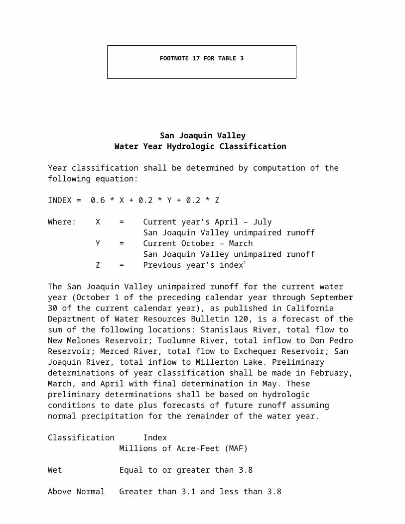
research on the selection of irrigation methods and crops for water and salt management.
• Drainage Reuse. Drainage reuse is a planned system of drainage water reuse on progressively more salt-tolerant plants. Drainage reuse will concentrate salts and trace elements for easier containment and safe disposal.
The ongoing and planned research and demonstration projects to develop drainage reuse technologies, and drainage treatment and disposal technologies, should continue and be completed. These projects include: DWR funding research on the impacts of reuse on wildlife; DFG conducting field studies on the impacts of reuse on wildlife; DFG and USFWS evaluating the potential impacts of agroforestry plantation on wildlife; continued DFA and NRCS testing and demonstrating agroforestry and the

use of halophyte plants; DFA providing quality control and coordination of demonstration projects; NRCS assisting farmers to plan, design, and manage drainage reuse programs; and USGS providing technical assistance and analysis regarding ground water and effluent storage to effect reuse of drainage water.
• Evaporation Systems. Evaporation systems consist of drainage water evaporation ponds planned for storage and evaporation of drainage water. Currently, evaporation ponds are the only means available for storage and disposal of drainage water in much of the southern San Joaquin Valley.
The agencies committed to implementing the programs regarding evaporation systems should continue or initiate the identified activities. These activities include: DWR and USFWS funding, and DFG and USFWS conducting, studies on the impacts of evaporation ponds on wildlife; DWR supporting demonstration projects of evaporation pond design improvements; DFG continuing to coordinate work with the Central Valley RWQCB, which is responsible for ensuring that ponds conform to the applicable water quality control plan; USBR funding demonstration projects for new or improved evaporation pond technologies; and NRCS working with farmers to develop and evaluate pond design and management criteria. In implementing their programs, the DWR, USFWS, and DFG should include field testing and demonstration projects to avoid or minimize wildlife hazards.
• Ground Water Management. Ground water management is planned pumping from deep within the semi-confined aquifer in places where near-surface water tables can be lowered and the water pumped is of suitable quality for irrigation or wildlife habitat.
The activities that are identified in the 1991 report should be implemented. These activities include: DWR development of a monitoring program; USGS hydrologic analyses required to implement demonstration projects to test ground water management; NRCS technical assistance to local agencies and farmers in the development and demonstration of on-farm high water table management; and USBR development of a program to encourage ground water management through incentives provided by water transfers.
• Institutional Measures. Institutional measures include tiered water pricing, improved scheduling of water deliveries, water transfers and marketing, and formation of regional drainage management organizations to aid in implementing other recommendations of the SJVDP.

The agencies committed to supporting institutional changes necessary to implement the SJVDP recommendations should continue or initiate the identified activities. These activities include: DWR actions to encourage and support methods such as tiered water pricing and water marketing; USBR initiation of trial arrangements for funding drainage projects; and USFWS assistance in drafting comprehensive legislation to authorize and fund the SJVDP's 1990 management plan. The SWRCB has committed to participate in a study of the use of an environmental recovery fund and price controls in water markets.
• Discharges to the San Joaquin River. Controlled and limited discharges of agricultural drainage water to the San Joaquin River must occur in a manner that meets water quality objectives. This may be best accomplished by coordinating the release of drainage water with higher flows in the river during the winter and spring periods when more dilution water is available, and when transport of drainage water would be consistent with fish migration needs. Adequate coordination may require the execution of agreements with dischargers, waste discharge requirements that restrict the discharge of drainage water to the river, or time-specific waste discharge prohibitions.
The agencies committed to implementing actions related to the drainage water discharge to the San Joaquin River should continue or initiate the activities identified by the SJVDP. These activities include: completion of the five-year interagency effort by the San Joaquin River Management Program (established and funded by the State Legislature, and led by the DWR) to develop a plan which includes management of agricultural drainage to the river; DWR and USBR real-time salt monitoring program for the river (with the cooperation of the Central Valley RWQCB); USGS investigations of surface water and ground water interaction to evaluate the quantity, quality, and timing of ground water contributions to the river; DFG and USFWS monitoring of the effects of implementing discharge controls to the river on fish and wildlife; and USBR planning for the San Luis Unit which could contribute substitute water supply and provide water control facilities needed to convey drainage water to the San Joaquin River downstream of the confluence with the Merced River. The SWRCB, with the support and cooperation of appropriate entities, is willing to consider the concept of a discharger with high productivity soils purchasing another discharger's waste load allocation, once developed, in the San Joaquin River basin.
In addition to the planned measures identified by the SJVDP, these agencies and the affected water districts should consider taking

advantage of winter flood flows to remove salts from low-lying areas in the San Joaquin Valley, either as part of a flood control program or pursuant to a permit from the SWRCB to appropriate water during high flow events. Also, the operators of wetlands receiving new water from the USBR under the CVPIA should participate in real-time management of their discharges to ensure that they do not cause violation of water quality objectives. If funding is needed for further work on salt discharge management, the Central Valley RWQCB could seek a grant under Clean Water Act section 319(h).
Out-of-Valley Disposal of Salts. In addition to the short-term management measures to reduce salt loading to the San Joaquin River and Delta, described above, it is necessary to begin planning for a long-term solution to the San Joaquin Valley drainage problem. Inadequate drainage, and accumulating salts and trace elements, are increasingly persistent problems in many parts of the San Joaquin Valley. These drainage problems threaten water quality, agriculture, fish and wildlife, and public health. Ultimately, it will be necessary for the in-basin management of salts to be supplemented by the disposal of salts outside of the San Joaquin Valley for protection of these beneficial uses to continue.
The USBR should reevaluate alternatives for completing a drain to discharge salts from agricultural drainage outside of the San Joaquin Valley and pursue appropriate permits. This evaluation should include the development of information on the potential effects on fish and wildlife habitat and populations in the receiving waters, and the physical, institutional, and economic feasibility of the various alternatives. Current State law prohibits the discharge of San Joaquin Valley agricultural drainage water to the Monterey Bay, and it is not the intent of this plan to reopen this issue.
C. Recommendations to Improve Habitat Conditions
There are numerous actions that can be taken, in addition to establishing and implementing water quality objectives for the Bay-Delta Estuary, to improve fish and wildlife beneficial uses in the Estuary. These actions involve improvements to habitat conditions both inside and outside of the Estuary, many of which are under the authorities of other agencies.
The SWRCB acknowledges that, as provided by the Principles for Agreement, there is an ongoing effort by State agencies, the federal government, and agricultural, urban, and environmental interests to identify, fund, and implement, as warranted, measures to address the broader non-flow-related range of factors potentially affecting water quality and habitat in the Bay-Delta Estuary. Potential measures under consideration by these entities include those that would be implemented outside of the Estuary itself. This effort, in connection with the other measures to implement the objectives in this plan, is seen as part of a comprehensive program to provide better

protection for the biological resources that depend on the Bay-Delta Estuary. The SWRCB recognizes that this effort may result in recommendations to other entities, public and private, that are new or different from those included in this plan and described below (parts 1-14). The SWRCB intends to consider incorporating any such recommendations in future proceedings to the extent appropriate.
Funding of these activities is expected to require a substantial financial commitment. Approximately 60 million dollars per year over the next three years should be allocated for this purpose. A portion of the funds needed for these activities will come from a prioritization of existing programs. Additional funds will be secured through a combination of federal and State appropriations, user fees, and other sources, as required. In the multi-party process established under the Principles for Agreement, water users groups, State and federal agencies, and environmental interests will determine priorities and financial commitments for the implementation of these activities. If funding by the parties is not forthcoming, the SWRCB will support legislation and consider other actions to secure funding for these purposes in connection with the water rights proceeding.
1. Reduce losses of all life stages of fishes to unscreened water diversions. Unscreened agricultural, municipal, and industrial water diversions entrain large numbers of eggs, larvae, and juvenile fishes in the Sacramento and San Joaquin river watersheds and the Delta.
To provide better protection for aquatic resources in the Bay-Delta Estuary, the National Marine Fisheries Service (NMFS) should continue its work on requirements for unscreened diversions on the Sacramento River. In addition, the NMFS, USFWS, and DFG should institute a program to evaluate water diversions within the San Joaquin River and the Delta. To reduce entrainment in the rivers and the Delta, these agencies should assess whether: (1) changes in the timing of diversions could be made to avoid peak concentrations of all life stages of fishes; and (2) changes in the management of water uses would be feasible to avoid entraining large numbers of fish. In evaluating Delta diversions, these agencies should: (1) decide where screens are needed; (2) consider whether diversion points should be relocated or consolidated; and (3) give their recommendations on changes in points of diversion to the SWRCB for consideration in a water rights proceeding. The SWRCB may use its authority to allow inspections of diversion facilities in cases where the other agencies are unable to obtain access.
This program should include the collection of data regarding the size and approach velocity of diversions, and the proximity of fish to the diversions when they are operating. The responsible agencies should complete the following actions by the dates indicated:

June 1996 Develop performance criteria for diversions (e.g., screen types and sizes, approach velocities, etc.).
June 1996 Develop testing specifications to assess if diversions are having an unreasonable effect on fish.
June 1996 Develop incentives to encourage diverters to consolidate and relocate diversions to the least environmentally sensitive locations.
June 1997 Notify diverters of the performance criteria (requirements) for their diversions and a time schedule for completing the requirements.
June 1997 Develop a monitoring program to be implemented upon installation of entrainment control devices.
June 1999 Develop necessary environmental documentation and require installation of entrainment control devices at the highest priority diversions.
June 2004 Develop necessary environmental documentation and require installation of entrainment control devices at selected lower priority diversions.

2. Reduce entrainment by, and improve fish survival at, the SWP and CVP export facilities. Despite the presence of screens at the diversions of the SWP and CVP in the southern Delta, substantial fish mortality is associated with the operations of these facilities.
The DWR and the USBR, in consultation with the DFG, USFWS, and NMFS, should evaluate and implement all feasible measures and programs to reduce entrainment and mortality of fish salvaged at the facilities of the Harvey O. Banks and Tracy pumping plants. These measures should include: (1) monitoring entrainment on a real-time basis to identify periods of peak susceptibility of various species; (2) coordinating operations of the two diversions, including interchangeable pumping, to reduce combined losses; (3) increasing screening efficiency; (4) improving fish salvage and handling; and (5) predator control at the SWP and CVP intakes. The SWRCB will consider requiring implementation of these measures and programs in the water rights proceeding following adoption of this plan.
3. Review and modify, if necessary, existing commercial and sport harvesting regulations. Current levels of sport and commercial fishing may be contributing to reduced fish populations in the Bay-Delta Estuary.
The DFG, California Fish and Game Commission, Pacific Fisheries Management Council, and NMFS should take the following actions within their respective authorities: (1) develop and implement a fisheries management program to provide short-term protection for aquatic species of concern through seasonal and area closures, gear restrictions to reduce capture and mortality of sub-legal fish, and other appropriate means; (2) review immediately, and then at least every two years, and modify, if necessary, existing harvest regulations to ensure that they adequately protect aquatic species; and (3) seek changes in trawling methods used by the commercial shrimp industry to reduce the incidental take of other aquatic species, either through an agreement with the industry or through regulations.
4. Reduce illegal harvesting. Illegal harvesting, which has a certain but unquantified impact on fisheries of the Bay-Delta Estuary, is particularly of concern for striped bass and chinook salmon. The DFG estimates that poaching claims about 500,000 undersized striped bass and an uncounted number of salmon annually.
The DWR and the DFG should expand the current illegal harvest enforcement program. Additionally, the DFG should develop and implement an educational program to curb poaching of fishery resources.
5. Evaluate the effectiveness of barriers as a means of improving fish survival in the Delta. The USBR currently operates the Delta Cross Channel gates to meet standards adopted by the SWRCB and other

agencies. The use of additional gates or other barriers in other Delta channels shows promise for helping to improve the survival of certain fish species, especially chinook salmon and steelhead trout. However, the effectiveness of such barriers, including the effects on other species and water quality in the central Delta, requires further evaluation.
The DWR and the USBR, in consultation with the DFG, USFWS, and NMFS, should: (1) test the use of barriers at the head of Old River and at other strategic locations within the lower San Joaquin River and Delta as a means of improving survival of migrating chinook salmon in the spring and fall; and (2) evaluate the advisability of closing Georgiana Slough by using either a physical barrier or an acoustic barrier. The barriers should be constructed if it is determined that they are effective and will neither harm other species, such as Delta smelt, nor have other significant adverse effects on the environment. If construction of barriers makes compliance with the water quality objectives in this water quality control plan problematic, the DWR or the USBR should request a change in this water quality control plan.
6. Reduce the impacts of introduced species on native species in the Estuary. The intentional and accidental introduction of non-native species has caused major changes in the composition of aquatic resources in the Bay-Delta Estuary; however, the exact impacts of existing introduced species on native species in the Estuary are not clear.
The DFG, USFWS, and NMFS should: (1) pursue programs to determine the impacts of introduced species, including striped bass, on the native aquatic resources of the Estuary, and the potential benefits of control measures; and (2) determine where ballast water can be released without posing a threat of infestation or spread of aquatic nuisance species, and limit the release of ballast water to those areas (by new legislation, if needed). The DFG should also: (1) continue its efforts under the Fish and Game Code sections 6430-6439 concerning introduced species, enacted in 1992; and (2) consider preparing a comprehensive management plan under the federal Nonindigenous Aquatic Nuisance Prevention and Control Act of 1990 (U.S.C. §§4701-4751) to obtain technical and financial assistance to eliminate the environmental, public health, and safety risks associated with aquatic nuisance species. Additionally, the California Fish and Game Commission should deny all requests for the introduction of new aquatic species into the watershed of the Bay-Delta Estuary unless it finds, based on strong, reliable evidence, that an introduction will not have deleterious effects on native species.
7. Improve hatchery programs for species of concern. Hatchery production of various fish species that use the Bay-Delta Estuary serves to: mitigate the loss of stream spawning and rearing habitat due to the construction of dams; mitigate increasing harvesting pressure; and provide short-term support for various species until other programs to improve fish

survival in the Estuary and its watershed are implemented. Because hatchery production compromises genetic diversity and often results in increased harvesting pressure on natural fish stocks, it should complement, not substitute, measures to improve the natural production and survival of fish species.
The DFG, NMFS, and USFWS should: (1) carefully examine and periodically reexamine the role and contribution of existing hatchery production for various fish species (e.g., chinook salmon, steelhead trout, striped bass) and experimental hatchery programs (e.g., Delta smelt), including a consideration of the need for genetic diversity and maintaining the integrity of different salmon runs; (2) evaluate strategies for improving the survival of hatchery fish, before and after release, including diet and pre-release conditioning, selection of the life stage and size of fish to be released, timing releases relative to the presence or absence of other species, and using multiple release locations; and (3) with the USBR, take steps to rehabilitate the Coleman Fish Hatchery, and to construct, if advisable, the Keswick Hatchery on the Sacramento River and a hatchery in the San Joaquin River watershed.
8. Minimize losses of salmon and steelhead due to flow fluctuations. Releases of water from the dams on most of the rivers tributary to the Delta can influence the locations where chinook salmon and steelhead trout spawn. Higher flows in the reaches below a dam can lead to spawning at locations in the riverbed that may be dewatered by subsequent reduced flows before the eggs hatch. These reductions in flow can strand fry in side channels and shallow backwaters that are isolated from the main river channel. While short-term increases in flow from storms often cannot be avoided, flow fluctuations due to scheduled releases of water can be managed to reduce adverse impacts on downstream fisheries.
The DFG, USFWS, and NMFS, in consultation with the DWR and the USBR, should: (1) evaluate the impoundment releases upstream of the Delta, considering factors that include the allowable size of flow reductions, appropriate ramping rates for increasing or decreasing flows, and flood control operations; (2) make recommendations, where appropriate, for changes in the operations of those impoundments to minimize adverse impacts on fishes caused by flow fluctuations; and (3) where appropriate, seek agreements from dam operators or make recommendations to the SWRCB for necessary changes in the water rights of these facilities.
9. Expand the gravel replacement and maintenance programs for salmonid spawning habitat. The construction of dams on the major tributaries of the Delta has blocked the movement of gravel eroding from upstream areas and has caused sediments to infiltrate the remaining gravels. Reduction in the availability of the riverbed gravels required for

salmonid spawning limits the success of chinook salmon and steelhead trout reproduction in the watershed of the Bay-Delta Estuary.
The DWR, the USBR, and other agencies that currently conduct gravel replacement and spawning habitat improvement programs on the Sacramento and San Joaquin river systems should continue and, where possible, increase their efforts in the reaches where salmonids are likely to spawn.
10. Evaluate alternative water conveyance and storage facilities of the SWP and CVP in the Delta. The current water diversion facilities of the CVP and the SWP in the southern Delta adversely impact fish populations. These facilities or alternative facilities are needed to meet water supply demands in areas south and west of the Delta. Various alternatives have been identified to minimize impacts to fish while meeting water supply demands. The proposed alternatives include construction of a water diversion intake on the Sacramento

River equipped with state-of-the-art fish screens, isolated and through-Delta water conveyance facilities, and new water storage facilities within and south of the Delta.
Consistent with the Framework Agreement regarding a long-term Bay-Delta Estuary solution, the agreement's signatory agencies should: (1) evaluate the feasibility, biological impacts and benefits, and likely operational criteria of various alternatives to the current water diversion facilities in the southern Delta; and (2) based on the evaluation, develop a project(s) that will meet the dual goals of minimizing impacts to aquatic resources while providing a reasonable supply of water for export.
11. Develop an experimental study program on the effects of pulse flows on fish eggs and larvae in the Delta. The magnitude of freshwater outflow passing through the Delta affects the geographic distribution of many planktonic fish eggs and larvae. The egg and larval stages of many fish species occur in the Delta during a relatively short period of time in the spring (April-June). When there is high freshwater outflow, the planktonic eggs and larvae are moved downstream into Suisun Bay where they are less susceptible to entrainment at the SWP and CVP diversions and at other diversion points within the Delta. Absent high outflows, the eggs and larvae tend to remain in the Delta. Short-term artificial increases in freshwater flows (pulse flows) can be used to move the eggs and larvae downstream into Suisun Bay. To improve the efficiency of water used for this purpose, it would be helpful to experimentally quantify the magnitude and duration of pulse flows needed to move a substantial proportion of fish eggs and larvae into Suisun Bay.
The DWR and the USBR should conduct experiments to investigate and evaluate the biological benefits of pulse flows to move planktonic fish eggs and larvae into Suisun Bay. These experiments, which should be conducted as soon as feasible, should: (1) involve flows released from both the Sacramento and San Joaquin rivers; (2) include real-time biological monitoring to determine the most favorable times for the pulse flows and the effects of the pulse flows on the eggs and larvae; (3) determine whether short-term pulse flows have a lasting benefit or whether, when outflows are reduced after a pulse flow, the larval fish are drawn back into interior Delta areas; and (4) take into account base flows and availability of water supplies. If results of the experiments were obtained soon enough, they could be used to refine potential pulse flow requirements in a water right decision implementing this water quality control plan.
12. Implement actions needed to restore and preserve marsh, riparian, and upland habitat in and upstream of the Delta. Most of the historical fish and wildlife habitat in the Delta and throughout the Central Valley has been eliminated or disturbed. The construction of dams for water storage on nearly all of the Bay-Delta Estuary's tributary streams

and the conversion of natural habitat to croplands eliminated significant amounts of habitat for species in the Central Valley. In the Delta, less than 100,000 acres of the total 738,000 acres remains as marsh, riparian, and upland habitat. The remainder of the area is highly altered due to conversion to agricultural land, industrial and urban development, and actions for flood control and navigation, such as dredging channels and riprapping banks.

Furthermore, many of the alterations that have already occurred require extensive ongoing maintenance, which also disrupts fish and wildlife habitat. Restoration of fish and wildlife habitat in and upstream of the Delta would benefit many species of the Bay-Delta Estuary.
State and federal agencies should require, to the extent of their authorities, habitat restoration in the Delta and upstream of the Delta as a condition of approving projects. For example, the Delta Protection Commission, in all of its actions under the Delta Protection Act of 1992 (Public Resources Code section 29700 et seq.) which provides for the coordination of local land use decisions in the Delta, should consider the need to restore and preserve marsh, riparian, and upland habitat in the Delta. The DFG, when it considers approving stream alterations, and the DFG, USFWS, and NMFS, when they consider projects that affect endangered species, should consider habitat requirements. The U.S. Army Corps of Engineers should consider habitat requirements in connection with applications for permits under Clean Water Act section 404. The Federal Emergency Management Agency should consider habitat requirements in establishing flood insurance requirements and levee standards. Within their authorities, these agencies should provide for: (1) levee setback requirements; (2) improvements in the productivity of aquatic areas throughout the Central Valley; (3) reductions in the depth of selected Delta channels, by using either dredge material from navigational channels or natural infill, to restore more productive shallows and shoals; (4) conversion of low-lying Delta islands to habitat areas; and (5) other habitat enhancement measures. The SWRCB will consider habitat requirements where needed to meet water quality standards under the Clean Water Act when approving section 401 certifications. Additionally, responsible governmental agencies and private parties should institute programs to increase riverine cover in the Bay-Delta Estuary watershed, if demonstrated to be effective in lowering water temperatures by providing shading.
13. Implement temperature control measures to reduce adverse impacts on salmon and steelhead. Cool water temperatures are important for the successful spawning, egg incubation, and juvenile rearing of chinook salmon and steelhead trout in rivers of the Central Valley. Water temperature is primarily influenced by seasonal changes in ambient air temperatures, the temperature of water released from rim reservoirs, and agricultural drainage return flows.
The USBR should, as soon as possible, implement the proposal for constructing a temperature curtain at Shasta Reservoir, which will permit the selective withdrawal of water from various locations within the water column while continuing to generate hydroelectric power. Additionally, the operators of other rim reservoirs should evaluate the impacts of their operations on downstream water temperatures and take actions to correct any significant adverse impacts on salmonid survival due to temperature. The SWRCB will consider incorporating appropriate temperature standards

into water right permits of rim reservoir operators. The Central Valley RWQCB should evaluate best management practices that could be implemented to reduce the impact of agricultural drainage return flows on the temperature of Central Valley rivers.

14. Implement measures to appropriately control Suisun Marsh soil and channel water salinities, including actions identified in the SMPA. The objectives for the Suisun Marsh in this plan regulate salinity in the channels of the marsh for the purpose of providing irrigation water for the managed wetlands that will bring soil water salinities into the range capable of supporting the plants characteristic of a brackish marsh. Four entities, the DWR, DFG, USBR, and SRCD, negotiated and signed the SMPA, which proposes changes in the salinity objectives for Suisun Marsh in certain dry and critical water years. The SMPA objectives, like the objectives adopted for the Suisun Marsh in the 1978 Delta Plan, would regulate channel water salinity. The soil water salinity, which is not directly regulated, depends upon the irrigation practices used by the various property owners of the managed wetlands in the Suisun Marsh. To provide more consistent protection for the managed wetlands in Suisun Marsh and the species these wetlands support, management practices should be used that will promote adequate soil salinity levels. With more uniform water distribution, it may be possible to protect the beneficial uses of water more efficiently than under current practices.
The DWR, USBR, DFG, and SRCD should: (1) continue the actions, including facility plans, identified for implementation of the SMPA; (2) conduct a study to determine the relationship between channel water salinity and soil water salinity under alternative management practices (including an assessment of whether the current channel water salinity objectives are needed to support the beneficial uses and whether different water quality objectives, including soil water salinity objectives, would provide equivalent or better protection for the beneficial uses if favorable management practices also are used); and (3) employ, together with the property owners in the Suisun Marsh, a watermaster to direct the timing and amounts of water diverted in the marsh to ensure that the water is used efficiently and the protection of beneficial uses is maximized. Additionally, pursuant to Public Resources Code section 9962, the SRCD should oversee and enforce water management plans for achieving water quality objectives for salinity in the Suisun Marsh. If possible, the watermaster should be employed under the provisions of Part 4, Division 2 of the Water Code (Wat. C. §§4000-4407), under which the parties could negotiate an agreement that includes the property owners in the marsh. The agreement should determine the rights to the use of water from the channels of the Suisun Marsh among the various claimants, and should specify rules for managing the water in the marsh to maximize the salinity control benefits of the water. To be valid, the agreement would have to be recorded in the office of the county recorder for Solano County, in which the Suisun Marsh is situated. Alternatively or conjunctively, the parties to the SMPA and the San Francisco Bay Conservation and Development Commission should establish a Suisun Marsh watermaster to help implement water management plans on private seasonal wetlands (i.e., managed diked wetlands).

Additionally, the DWR should convene a Suisun Marsh Ecological Work Group, consisting of representatives of the SWRCB, San Francisco Bay RWQCB, DWR, DFG, San Francisco Bay Conservation and Development Commission, USBR, USFWS, NMFS, USEPA, National Biological Survey, SRCD, Ducks Unlimited, California Waterfowl Association, National

Audubon Society, California Native Plant Society, and other interested parties. The work group will: (1) evaluate the beneficial uses and water quality objectives for the Suisun Bay and Suisun Marsh ecosystem; (2) assess the effects on Suisun Bay and Suisun Marsh of the water quality objectives in this plan and the federal Endangered Species Act biological opinions; (3) identify specific measures to implement the narrative objective for tidal brackish marshes of Suisun Bay and make recommendations to the SWRCB regarding achievement of the objective and development of numeric objectives to replace it; (4) identify and analyze specific public interest values and water quality needs to preserve and protect the Suisun Bay/Suisun Marsh ecosystem; (5) identify studies to be conducted that will help determine the types of actions necessary to protect the Suisun Bay area, including Suisun Marsh; (6) perform studies to evaluate the effect of deep water channel dredging on Suisun Marsh channel water salinity; (7) perform studies to evaluate the impacts of urbanization in the Suisun Marsh on the marsh ecosystem; and (8) develop a sliding scale between the normal and deficiency objectives for the western Suisun Marsh7.
D. Monitoring and Special Studies Program
A monitoring and special studies program should be established to provide physical, chemical, and biological data that will: (1) provide baseline information and determine compliance with the water quality objectives in this plan; (2) evaluate the response of the aquatic habitat and organisms to the objectives; and (3) increase understanding of the large-scale characteristics and functions of the Estuary ecosystem to better predict system-wide responses to management options. Since these last two goals include more than routine monitoring elements, they are referred to in this plan as "special studies". The monitoring and special studies program will be implemented by the SWRCB through the water right decision.
The monitoring and special studies program is predicated on the ongoing monitoring efforts of the Interagency Ecological Program (IEP), of which the SWRCB is a participant. The program will be coordinated with both IEP and non-IEP monitoring activities, such as the San Francisco Estuary Institute's San Francisco Estuary Regional Monitoring Program and the monitoring activities associated with the CVPIA, to minimize duplication and facilitate the exchange of data. Between the adoption of this plan and the adoption 7 ? The USBR, DWR, DFG, and SRCD are working together to develop a sliding scale between SMPA normal and deficiency standards for the western Suisun Marsh based on the previous month's Eight River Index. The sliding scale will result in standards more consistent with the hydrologic conditions in the Estuary on a monthly basis, and will more closely reflect the natural hydrodynamic linkage between the Suisun Bay, Suisun Marsh, and the Delta. The sliding scale will also avoid setting western Suisun Marsh standards based on the hydrology for an entire year (normal versus deficiency) in advance. When the four agencies, in cooperation with the entire work group, have developed and agreed upon a sliding scale, they will petition the SWRCB to adopt it for the western Suisun Marsh and will incorporate it into the SMPA.

of the water right decision, the IEP monitoring and special studies program will be revised to account for the requirements of this plan; therefore, only general aspects of the program are presented here.A preliminary compliance and baseline monitoring program is provided in Table 4. Figure 2 shows the locations of the monitoring stations on a map of the Estuary. The SWRCB recognizes that a more appropriate compliance and baseline monitoring program may be developed by the IEP once the participating agencies and interested parties have fully assessed the new information requirements. Until a final compliance monitoring program is established through the water right decision, the SWRCB will work with the DWR, the USBR, and interested parties to develop modifications to the monitoring program.
A special studies program similar to that being conducted by the IEP at the time of adoption of this plan should be continued. As with compliance and baseline monitoring, the SWRCB recognizes that these studies, and their associated monitoring activities, may need to be modified to reflect the objectives in this plan and new knowledge about the Bay-Delta system. The special studies should emphasize understanding the ecological responses of species of special concern to water project operations resulting from implementation of this plan, and should enhance knowledge of how the Estuary responds to factors other than the operational impacts of water development facilities. As a member of the IEP, the SWRCB will work with all interested parties in developing a responsive special studies program.
As it may use the results of special studies as input to any decisions that it will make during the triennial review of this plan, the SWRCB urges the agencies and interested parties to work cooperatively to develop the special studies program. The SWRCB believes that the studies should be subjected to a peer review process to reduce controversy concerning the design of the studies and the interpretation of their results.
The agencies and interested parties are also developing a near-real-time monitoring program to assist the operations group acting pursuant to the Principles for Agreement. The SWRCB will participate in the development of that program, as it will affect the way in which the SWP and the CVP are operated to comply with the objectives in this plan.

Table 4. Water Quality Compliance and Baseline Monitoring
Station Number
StationDescription Cont
.Rec.1
Physical/
Chem-ical2
Multi-para-
meter3
Phyto-plank-ton4
Zoo-plank-ton4
Ben-thos4
C2 Sacramento River @ Collinsville *C3 Sacramento River @ Greens Landing * * *
C4 San Joaquin River @ San Andreas Ldg. *
C5 Contra Costa Canal @ Pumping Plant #1 *
C6 San Joaquin River @ Brandt Bridge site *
C7 San Joaquin River @ Mossdale Bridge *
C8 Old River near Middle River *C9 • West Canal at mouth of CCForebay Intake * *
C10 • San Joaquin River near Vernalis * *C13 Mokelumne River @ Terminous *C14 Sacramento River @ Port Chicago *C19 Cache Slough @ City of Vallejo Intake *
D4 Sacramento River above Point Sacramento * * * *
D6 Suisun Bay @ Bulls Head Pt. nr. Martinez * * * * *
D7 Grizzly Bay @ Dolphin nr. Suisun Slough * * * *
D8 Suisun Bay off Middle Point near Nichols * * *
D10 • Sacramento River @ Chipps Island * *D12 • San Joaquin River @ Antioch Ship Canal * *
D15 San Joaquin River @ Jersey Point *D16 San Joaquin River @ Twitchell Island * *D22 • Sacramento River @ Emmaton *D24 • Sacramento River below Rio Vista Bridge * *
D26 San Joaquin River @ Potato Point * * *D28A Old River near Rancho Del Rio * * * * *D29 San Joaquin River @ Prisoners Point *D41 San Pablo Bay near Pinole Point * * *D41A San Pablo Bay nr. mouth of Petaluma R. *
DMC1 • Delta-Mendota Canal at Tracy Pump. Plt. *
P8 San Joaquin River @ Buckley Cove * * * * *P12 Old River @ Tracy Road Bridge *MD10 Disappointment Slough near Bishop Cut * * *
S21 Chadbourne Slough @ Sunrise Duck Club *
S35 Goodyear Sl. @ Morrow Is. Clubhouse *
S42 • Suisun Slough 300' so. of Volanti Slough * *
S49 Montezuma Slough near Beldon Landing *

S64 Montezuma Slough @ National Steel *
S97 Cordelia Slough @ Ibis Club *NZ032 Montezuma Slough, 2nd bend from mouth *
NZ080 San Joaquin River, 549 meters upstream of light 26 *
(continued) Compliance monitoring station Baseline monitoring station • Compliance and baseline monitoring station
Table 4. Water Quality Compliance and Baseline Monitoring (continued) Station Number StationDescription Cont.
Rec.1
Physical/Chem-ical2
Multi-para-meter3Phyto-plank-ton4
Zoo-plank-ton4 Ben-thos4
--- Sacramento R. (I St. Bridge to Freeport)(RSAC155)
*
--- San Joaquin R. (Turner Cut to Stockton)(RSAN050-RSAN061)
*
--- Barker Sl. at No. Bay Aqueduct (SLBAR3) *
--- Water supply intakes for waterfowl management areas on Van Sickle Island and Chipps Island *
Compliance monitoring station Baseline monitoring station • Compliance and baseline monitoring station
1 Continuous recorder only (EC, dissolved oxygen, and/or temperature) for purpose of compliance. For municipal and industrial intake chlorides objectives, EC can be monitored and converted to chlorides.
2 Physical/chemical monitoring is conducted monthly at discrete sites and includes the following parameters: water column depth, secchi, nutrient series (inorganic and organic N-P), water temperature, dissolved oxygen, electrical conductivity, turbidity, and chlorophyll a. In addition, on-board recording for vertical and horizontal profiles is conducted intermittently for the following parameters: water temperature, dissolved oxygen, electrical conductivity, turbidity, and chlorophyll a.
3 Multi-parameter monitoring is conducted continuously and provides telemetered data on the following parameters: water temperature, pH, dissolved oxygen, electrical conductivity, turbidity, chlorophyll a, wind speed and direction, solar radiation, air temperature, and tidal elevation.
4 Sampling occurs monthly at discrete sites._____________________________________________________________________________________________

Figure 2, Bay-Delta Estuary Monitoring Stations, which appears in the SWRCB's May 1995 WQCP, is a graphic not compatible with this word processing program, and, thus, cannot be shown here.