0 cd v-utab^ocdimage.emnrd.state.nm.us/imaging/filestore/hobbs/wf/257607/... · 1 1 change plans 1...
TRANSCRIPT

0 CD V-Utab^ f ™ 3 1 * 5 UNITED STATES
c h 2 ' 2 ) DEPARTMENT OF THE INTERIOR BUREAU OF LAND MANAGEMENT
SUNDRY NOTICES AND REPORTS ON WELLS Do nor use this form for proposals to drill or to re-enter an
abandoned well. Use Form 3160-3 (APD) for such Prpvosal^ ~
FORM APPROVED OMB No. 1004-0137
Expires: October 31, 2014
0 CD V-Utab^ f ™ 3 1 * 5 UNITED STATES
c h 2 ' 2 ) DEPARTMENT OF THE INTERIOR BUREAU OF LAND MANAGEMENT
SUNDRY NOTICES AND REPORTS ON WELLS Do nor use this form for proposals to drill or to re-enter an
abandoned well. Use Form 3160-3 (APD) for such Prpvosal^ ~
5. Lease Serial No. NM14492
0 CD V-Utab^ f ™ 3 1 * 5 UNITED STATES
c h 2 ' 2 ) DEPARTMENT OF THE INTERIOR BUREAU OF LAND MANAGEMENT
SUNDRY NOTICES AND REPORTS ON WELLS Do nor use this form for proposals to drill or to re-enter an
abandoned well. Use Form 3160-3 (APD) for such Prpvosal^ ~
6. If Indian, Allottee or Tribe Name
SUBMIT IN TRIPUCA TE - O t h e r instructions on page 2. 7. If Unit of CA/Agreement, Name and/or No.
I. Type of"Well g r ; p £ 0 2 0 1 4
G _ Oil Well • Gas Well • Other
7. If Unit of CA/Agreement, Name and/or No.
I. Type of"Well g r ; p £ 0 2 0 1 4
G _ Oil Well • Gas Well • Other 8. Well Name and No,
8105 JV-P Mesa #2H
2. Name of Operator BTA Oil Producers LLC ^ ( R E C E I V E D
9. API Well No. 30-025-41289 ^
3a.'Address 3b, Phone No. (include area code) 104 S Pecos r Midland, TX 79701 432-682-3753
10. Field and Pool or Exploratory Area
Jennings; Upper Bone Spring Shale
4. Location of Well (Footage. Sec. T.Jl.M., or Survey Description) 330' FNL & 430' FWL NWNW Sec. 11 ^ £ ^ _ j j ^ £T / ^ ' ~
11. County or Parish, State
Lea Co., NM
12. CHECK THE APPROPRIATE BOX(ES) TO INDICATE NATURE OF NOTICE, REPORT OR OTHER DATA
TYPE OF SUBMISSION TYPE OF ACTION
1 •/ 1 Notice of Intent
| | Subsequent Report
I | Final Abandonment Notice
1 \ Acidize
1 I Alter Casing
1 1 Casing Repair
1 1 Change Plans
1 | Convert to Injection
1 1 Deepen
1 I Fracture Treat
1 1 New Construction
1 1 Plug and Abandon
1 1 Plug Back
1 1 Production (Start/Resume)
1 I Reclamation
1 1 Recomplete
1 1 Temporarily Abandon
1 1 Water Disposal
1 1 Water Shut-Off
1 I Well Integrity
[Zl Other F r a c P o n d
13. Describe Proposed or Completed Operaiion: Clearly state all pertinent details, including estimaied starting date of any proposed work and approximate duration thereof. If the proposal is to deepen directionally or recomplete horizontally, give subsurface locations and measured and true vertical depths of all pertinent markers and zones. Attach the Bond under which the work will be performed or provide the Bond No. on file with BLM/BIA. Required subsequent reports must be filed within 30 days following completion of the involved operations. If the operation results in a multiple completion or recompletion in a new interval, a Form 3160-4 must be filed once testing has been completed. Final Abandonment Notices must be filed only after all requirements, including reclamation, have been completed and the operator has determined that the site is ready for final inspection.)
BTA respectfully requests approval for a frac pond to service our proposed 8105 JV-P Mesa #2H and 8105 JV-P Mesa #3H (30-025-41290).
Location plat and copy of cultural report (original provided directly to the BLM by Boone Archaeological Services).
14. I hereby certify that the foregoing is true and correct. Name (Printed/Typed)
Pam Inskeep Title Regulatory Administrator
Signature Date 03/25/2014
THIS SPACE FOR FEDERAL OR STATE OFFICE USE
ied. Approval ol this notice does notwa
Approved by
Conditions of approval, if any. are attached. Approval of this notice does not warrant or certify that the applicant holds legal or equitable title to those rights in the subject lease which would entitle the applicant to conduct operations thereon.
FIELD MANAGER Title Date SUM officGARLSBAD FIELD OFFICE
Title 18 U.S.C. Section 1001 and Title 43 U.S.C. Section 1212, make it a crime for any person knowingly and willfully to make to any department or agency of the United States any false, fictitious or fraudulent statements or representations as to any matter within its jurisdiction.
(Instructions on page 2)
SEP 3 0 201f

N89-362'5T 2673.0'
10 GEO "1939" B.C.
1/4 CORNER CLO "1939" B.C.
®
/ / BPJ, _
/
i/4 CORNER J CLO "1939" B.CY
4-W ELEC. LINE
"IZ. •rr"
^- 350 x 300 • EXISTING WELL1 PAD
l
N89'20jt3X_ 263.4' (TIE)
EXIST. 8105 JV-P MESA pH
jP.O.B S89°59'I0"E 375.0'
USA
BERM 300 0' _
CD
5^3ACRES
300 0'
1
BERM N89°59'10"W 375.0'
LEGEND
DENOTES FOUND CORNER AS NOTED
MOTE BEARINGS SHOWN HEREON ARE MERCA TOR GRID AND CONFORM TO THE NEW MEXICO COORDINATE SYSTEM "NEW MEXICO EAST ZONE" NORTH AMERICAN DATUM 1983. DISTANCES ARE SURFACE VALUES.
I, GARY C. EIDSON, NEW MEXICO PROFESSIONAL SURVEYOR No. 12641, DO HEREBY CERTIFY THAT THIS:%RKY:$EAp'AND THE ACTUAL SURVEY ON THE GROUND UPONfVjHICH TT is'-BAS'Ep WERE PERFORMED BY ME OR UNDER MY DlRE'Cli.'-SUPERVlSiON;, THAE %AM RESPONSIBLE FOR THIS SURVEY; THA TiflHIS: SURVE'Y'MEETSTHE MINIMUM STANDARDS FOR SURVEYING IN'NEW MEXICO;'"AND THAT IT IS TRUE AND CORRECT TO THE BEST "OF MY^KtiOY/LEDGE AND:BELIEF. /
DESCRIPTION:
A PROPOSED FRAC POND SITUATED IN THE NORTHWEST QUARTER OF SECTION 11. TOWNSHIP 26 SOUTH, RANGE 32 EAST, N.M.P.M., EDDY COUNTY, NEW MEXICO AND BEING MORE PARTICULARLY DESCRIBED AS FOLLOWS:
BEGINNING AT THE NORTHWEST CORNER OF THE PROPOSED FRAC POND WHICH LIES S00'39'17"E 480.2 FEET AND N89'20'43"E 263.4 FEET FROM THE NORTHWEST CORNER OF SAID SECTION; THEN S89-59'W"E 375.0 FEET; THEN S00V0'50"W 375.0 FEET; THEN N89'59'10"W 375.0 FEET; THEN N00V0'50"E 375.0 FEET TO THE POINT OF BEGINNING AND CONTAINING 3.23 ACRES MORE OR LESS.
200 EEC
200 ECE3ZHZEEC
400 Feet 1
Scale: !"=200'
GARY G. EiDSON P j ^ J l :
DATE: t i M M
r PROVIDING SURVEYING SERVICES SINCE 1916
JOHN WEST SURVEYING COMPANY <«].- N. DAI. PASO HOBBS. N.M. 88240
(S7S) 393-3117 www.jwsc.biz T8PLS* 10021000
BTA OIL PRODUCERS SURVEY FOR 8105 JV-P MESA #2H & U3H FRAC POND
SITUATED IN THE NW/4 OF SECTION 11, TOWNSHIP 26 SOUTH, RANGE 32 EAST, N.M.P.M.
LEA COUNTY, NEW MEXICO
Survey Dote: 2/13/14
W.O. No.: 14110152
CAD Dote: 2/24/14 Drown By. ACK
Rev: Rel. W.O.: Sheel 1 of 1
o*ite>s\F>ot W-iii Pad:; U1IC

NMCRIS No.: 130112
NMCRIS INVESTIGATION ABSTRACT FORM (NIAF)
1. NMCRIS 2a. Lead Agency: 2b. Other Agency: 3. Lead Agency Report No.: Activity No.:
US Bureau of Land Management Carlsbad Field
Activity No.: US Bureau of Land Management Carlsbad Field
130112 Office
4. Title of Report:
Class III Archaeological Survey for BTA Oil Producers Proposed 8105 JV-P Mesa No. 2H and 3H Frac Pond
Author:
Stephen Smith
5. Type of Report
g Negative
r~j Positive
6. Investigation Type
j—[Research Design ^Archaeological Survey/Inventory j—j Architectural Survey/Inventory r-jTest Excavation r—j Excavation
j—j Collections/Non-Field Study [—j Compliance Decision Based on Previous Inventory J—J Overview/Lit Review r—j Monitoring
j—j Ethnographic Study j—jSite/Property Specific Visit j—j Historic Structures Report j—jOther
7. Description of Undertaking (what does the project entail?):
BTA Oil Producers plan to construct the proposed 8105 JV-P Mesa No. 2H and 3H frag pond. On March 12, 2014, Stephen Smith with Boone Arch Services of New Mexico, LLC conducted an intensive pedestrian cultural survey for the proposed frac pond. Although the frac pond was staked at 300 ft by 300 ft, a 100 ft cultural safety buffer was surveyed. The frac pond survey was 500 ft by 500 ft (5.74 acres). Because of interaction with a BLM previous survey (buried pipeline), a 100 ft by 600 ft area (1.38 acres) was deducted from the current survey acres for the frac pond. A total of 4.36 acres was surveyed, all of which is on land administered by the Bureau of Land Management-Carlsbad Field Office.
[ ] Continuation
8. Dates of Investigation: 12-Mar-2014 9. Report Date: 22-Mar-2014
10. Performing Agency/Consultant: Boone Arch Services of New Mexico, LLC
Principal Investigator: Rebecca L. Hill
Field Supervisor: Stephen Smith
Field Personnel Names: Stephen Smith
Historian / Other:
11. Performing Agency/Consultant Report No.:
BASNM 02-14-48
12. Applicable Cultural Resource Permit No(s):
BLM: 190-2920-12-R State: NM-14-157-S

NMCRIS No.: 130112
13. Client/Customer (project proponent):
BTA Oil Producers
Contact: Pam Inskeep
Address: 104 S. Pecos, Midland, TX 79701 Phone: (432)682-3753
14. Client/Customer Project No.: N/A
15. Land Ownership Status (must be indicated on project map):
Land Owner (By Agency) Acres Surveyed Acres in APE
US Bureau of Land Management Carlsbad Field Office 4.36 2.07
TOTALS 4.36 2.07
16. Records Search:
Date of HPD/ARMS File Review: 3-11-14 Name of Reviewer: Stephen Smith
Date of Other Agency File Review: 3-11-14 Name of Reviewer: Stephen Smith Agency: (BLM-CFO) Bruce Boeke I
17. Survey Data:
a. Source Graphics [ ] NAD 27 [X] NAD 83 Note: NAD 83 is the NMCRIS standard.
j^ jUSGS 7.5' (1:24,000) topo map r j O t h e r topo map, Scale:
r^ jGPSUnit Accuracyr j<1.0m r-]1-10m g10-100m r j > 1 0 0 m Q A e r i a l Photo(s)
Other Source Graphic(s):
USGS Quad Code
32103-A6
b. USGS 7.5' Topographic Map Name
Paduca Breaks West, NM (1973)
c. County: Lea
d. Nearest City or Town: Jal, New Mexico
e. Legal Description:
Township (N/S) Range (E/W) Section
26 South 32 East 11
Projected legal description? [ ] Yes [ ] No [ ] Unplatted
f. Other Description (e.g. well pad footages, mile markers, plats, land grant name, etc.):
Plats for the proposed frac pond were submitted by BTA Oil Producers.
[ ] Continuation
18. Survey Field Methods:
Intensity: g 100% coverage j—j<100% coverage
Confiauration: rra block survey units r—i linear survev units (I x w):

NMCRIS No.: 130112
rnoiher survey units (specify):
Scope: r j j non-selective (all sites/properties recorded) r~J selective/thematic (selected sites/properties recorded)
Coverage Method: J7^jsystematic pedestrian coverage
rj]other method (describe):
Survey Interval (m): 15 Crew Size: 1 Fieldwork Dates: 12-Mar-2014
Survey Person Hours: 2.50 Recording Person Hours: 0.00 Total Hours: 2.50
Additional Narrative:
The comers for the proposed 300 ft by 300 ft frac pond were staked. An approximate 100 ft cultural buffer was surveyed around the entire staked block.
[ ] Continuation
19. Environmental Setting (NRCS soil designation; vegetative community; elevation; etc.):
Topography: Slight southeasterly slope, deep sand, south margin of Paduca Breaks, approximately 0.50 miles north of Red Hills Draw
Elevation: 3,240 ft
Vegetation: Shin oak, mesquite, prickly pear, & various grasses
Visibility: 55-65 percent due to vegetative cover NRCS: Pyote-Maljarrtar-Kermit association: Gently undulating and rolling, deep, sandy, soils
[ ] Continuation
20. a. Percent Ground Visibility: 55-65 percent b. Condition of Survey Area (grazed, bladed, undistributed, etc.):
The project area has been disturbed by a buried pipeline and cattle grazing.
[ ] Continuation
21. CULTURAL RESOURCE FINDINGS r j Yes, see next report section g No, discuss why:
Two isolated manifestations were encountered and recorded. See page 5
[ ] Continuation
22. Attachments (check all appropriate boxes):
[X] USGS 7.5 Topographic Map with sites, isolates, and survey area clearly drawn (required)
[X] Copy of NMCRIS Map Check (required)
[ ] LA Site Forms - new sites (with sketch map & topographic map) if applicable
[ ] LA Site Forms (update) - previously recorded & un-relocated sites (first 2 pages minimum)
[ ] Historic Cultural Property Inventory Forms, if applicable
[X] List and Description of Isolates, if applicable
[ ] List and Description of Collections, if applicable
23. Other Attachments:
[ ] Photographs and Log [ ] Other Attachments

24. 1 certify the information provided above is correct and accurate and meets all applicable agency standards.
Principal Investigator/Qualified Supervisor: Printed Name: Rebecca L. Hill
Stephen Smi th^ ' ^ ' j Signature: c Z y f ( K - - , \ A , ^ ^~~%A Date: 3-23-14 Title: Field Supervisor
25. Reviewing Agency 26. SHPO
Reviewer's Name/Date: Reviewer's Name/Date:
Accepted [ ] Rejected [ ] HPD Log #:
Date sent to ARMS:
CULTURAL RESOURCE FINDINGS [fill in appropriate section(s)]
SURVEY RESULTS:
Archaeological Sites discovered and registered: 0
Archaeological Sites discovered and NOT registered: 0
Previously recorded archaeological sites revisited (site update form required): 0
Previously recorded archaeological sites not relocated (site update form required): 0
TOTAL ARCHAEOLOGICAL SITES (visited & recorded): 0
Total isolates recorded: 2 Non-selective isolate recording?
HCPI properties discovered and registered: 0
HCPI properties discovered and NOT registered: 0
Previously recorded HCPI properties revisited: 0
Previously recorded HCPI properties not relocated: 0
TOTAL HCPI PROPERTIES (visited a recorded, including acequias): 0
MANAGEMENT SUMMARY:
Because no significant cultural resources were encountered during this survey, BTA Oil Producers proposed frac pond is recommended as presently staked. If cultural resources are encountered during any construction related activity, construction shouid cease and an archaeologist with the BLM-CFO should be immediately notified.
- [ ] Continuation
IF REPORT IS NEGATIVE, YOU ARE DONE AT THIS POINT.
SURVEY LA/HCPI NUMBER LOG
Sites/Properties Discovered:
LA/HCPI No. Field/Agency No. Eligible? (Y/N/U, applicable criteria)
NMCRIS No.: 130112
Previously recorded revisited sites/HCPI properties:
LA/HCPI No. Field/Agency No. Eligible? (Y/N/U, applicable criteria)
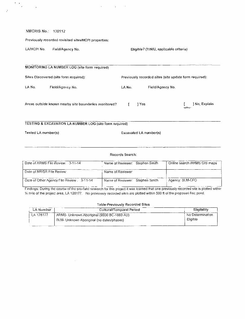
MONITORING LA NUMBER LOG (site form required)
Sites Discovered (site form required): Previously recorded sites (site update form required):
LA No. Field/Agency No. LA No. Field/Agency No.
Areas outside known nearby site boundaries monitored? [ ] Yes [ ] No, Explain
TESTING & EXCAVATION LA NUMBER LOG (site form required)
Tested LA number(s) Excavated LA number(s)
Records Search:
Date of ARMS File Review: 3-11-14 Name of Reviewer: Stephen Smith Online search /ARMS GIS maps
Date of NR/SR File Review: Name of Reviewer:
Date of Other Agency File Review : 3-11-14 Name of Reviewer: Stephen Smith Agency: BLM-CFO
Findings: During the course of the pre-field research for this project it was learned that one previously recorded site is plotted within % mile of the project area, LA 128177. No previously recorded sites are plotted within 500 ft of the proposed frac pond.
Table-Previously Recorded Sites
LA Number Cultural/Temporal Period Eligibility
LA 128177 ARMS- Unknown Aboriginal (9500 BC-1880 AD)
BLM- Unknown Aboriginal (no dates/phases)
No Determination Eligible

Survey for BTA Oil Producers' Proposed 8105 JV-P Mesa No. 2H and No. 3H Frac Pond

HOBSS OCD j 93.-
JUL 2 3 2013 OCD Hobbs
Form 3160-5 (Fcbruarv 2005) . ._• _- ._ . .- : •.
RECEIVED UNITED STATES
DEPARTMENT OF THE INTERIOR BUREAU OF LAND MANAGEMENT
APPLICATION FOR PERMIT TO DRILL OR REENTER
FORM APPROVED 0MB No. 1004-0137 -
' Expircs"Mir~di 11','2007 '
Form 3160-5 (Fcbruarv 2005) . ._• _- ._ . .- : •.
RECEIVED UNITED STATES
DEPARTMENT OF THE INTERIOR BUREAU OF LAND MANAGEMENT
APPLICATION FOR PERMIT TO DRILL OR REENTER
5. Lease Serial No. NM 14492
Form 3160-5 (Fcbruarv 2005) . ._• _- ._ . .- : •.
RECEIVED UNITED STATES
DEPARTMENT OF THE INTERIOR BUREAU OF LAND MANAGEMENT
APPLICATION FOR PERMIT TO DRILL OR REENTER 6. If Indian. Allotee or Tribe Name
la. Type of work: [ 7 ] DRILL E D REENTER
lb. Type or Well: [ T j o i l Well Q Gas Well [ ^O i l i e r [/J.Single Zone Q Multiple Zone
7 If Unit or CA Agreement, Name and No. la. Type of work: [ 7 ] DRILL E D REENTER
lb. Type or Well: [ T j o i l Well Q Gas Well [ ^O i l i e r [/J.Single Zone Q Multiple Zone
I L y i U ^ m i u m i i M l No. Z
1 ^ 1 0 5 JV-P^Wesajt2H ^
2 Name or Operator s 'S BTA Oil Producers, LLC s\ f
9. API Well N Q ^ ^ " 4
3a. Address | 0 4 S , V m K
Mid l i im l .TX 79701
3b. rhone No. (include area ufae)
(432) 682-37S3
10. Field-and Pool, or Exploratory
Jennings; Upper Bone Spring Shale
4. Location of Well (Rejxui lucoiiun clearly and in aixonkuxiti wiih any Stole requirement*. 'J
Aisurfacc 330' FNL & 430' FVVI. NWNW Sec. 11 &
At proposed prod, zone 330' FSL & 430' FWL SWSW Sec. il f%.V\\^-ffl
11. Sec, T. R. M. oi 131k and Survey or Area T>
Sec. 11.T26S-R32E
14. Distance in miles and direction rrom nearest town or post office* 25 miles west from Jal, N M
12. Counry oi Parish 13. State
Lea N M
15 Distance from proposed* location to nearest properly or lease line, ft. (Also to nearest drig. unit line, if any) 3 3 0 '
16. No. of acres in lease
1960
17. Spacing Unit dedicated to this well
160 acres
18. Distance from proposed location' to nearest well, drilling completed, applied for, on this lease, Ii. ' ' 3 1 D H L . to M I L
19, Proposed Deprfi
14,023' M D 9,540' TVD
20 BLM/BIA Bond No. on Me
NM1I95 NMB000849
21. Elevations (Show whether DF, KDB, RT, GL, etc.)
3242' G L
22 Approximate date work will start'
05/01/2013
23. F.stimaicd duration
45 doys
'71
24. Attachments
The following, completed in accordance with the requirements of Onshore Oil and Gas Order No. I, musl be attached io this form:
1. Well plat certified by a registered surveyor.
2. A Drilling Plan.
3. A Surface Use Plan (if the location is on National Forest System Lands, the SUPO must be filed with the appropriate Forest Service Office).
4. Bond to cover the operations unless covered by an existing bond on file (see
Item 20 above).
5. Operator certification
6 Such other site specific information and/or plans as may be required by the BLM.
Name (Printed/Typed)
Pam Inskeep
Date
01/02/2013
Title Regulatory Administrator
Approved by (Sipuuure) /s/George MacDonell
Name (Prinled'Typed) Dal
Title FIELD MANAGER
Office
CARLSBAD HELD O F R C E Application approval does not warrant or certify that the applicant holds legal or equitable title to those rights in the subject lease which would entitle the applicant to
S r ^ X u f l u . y . « attached. A P P R O V A L F O R T W O Y E A R S
Title 18 U.S.C. Section 1001 and Title 43 U.S.C. Section 1212, make it a crime foi any person knowingly and willfully to make to any department or agency of the United Stales any false, fictitious oi fraudulent statements oi representations as to any matter within its jurisdiction.
•(Instructions on page 2)
irlsbad Controlled Water Basin
OPERATOR WILL BE USING A CLOSED-LOOP SYSTEM
SEE ATTACHED FOR CONDITIONS OF APPROVAL
JUL 3 1 2013

OCD Hobbs
HOBBS OCD Form 3160-3 (February 200S) _ _ . .
UNITED STATES ^ i l 2 3 ZOij DEPARTMENT OF THE INTERIOR BUREAU OF LAND MANAGEMENT
RPCEiVED APPLICATION FOR PERMIT TO DRILL OR REENTER
FORM APPROVED 0MB No. 1004-0137
Ex'ps'Marcfc' 31; 2007' ' '
Form 3160-3 (February 200S) _ _ . .
UNITED STATES ^ i l 2 3 ZOij DEPARTMENT OF THE INTERIOR BUREAU OF LAND MANAGEMENT
RPCEiVED APPLICATION FOR PERMIT TO DRILL OR REENTER
5, Lease Serial No. NM 14492
Form 3160-3 (February 200S) _ _ . .
UNITED STATES ^ i l 2 3 ZOij DEPARTMENT OF THE INTERIOR BUREAU OF LAND MANAGEMENT
RPCEiVED APPLICATION FOR PERMIT TO DRILL OR REENTER
6. If Indian, Allotee or Tribe Name
la. Type of work; 0 DRILL Q REENTER
lb. Type of Well: [ / [ o i l Well | |Gas Well | |Olhci f v j s i ng l c Zone | | Multiple Zone
7 If Unit or CA Agreement. Name and No. la. Type of work; 0 DRILL Q REENTER
lb. Type of Well: [ / [ o i l Well | |Gas Well | |Olhci f v j s i ng l c Zone | | Multiple Zone
IJ^^w^^A No. / ^£^8105 JV-r|MesaJ/3H \
2. Name of Opcraior *
H I A Oi l Producers, L L C ^ l M > D 7 >
9 API Well No.
3a. Address 104 s. Pecos
Mid land, TX 79701
3b. Phone No. (include cale)
(432) 682-3753
10. Field and Pool, or Exploratory
.lennings; Upper Bone Spring S h a l e ^
4. Location ol Well (Report lutaliun clearly and in iKxardance with any Sluts requirement*.'}
At surface 265'FSL & 20S 'FWL SWSW S e c t [ \ H \
Al proposed prod zone 330 'FNL & 4 3 0 ' F W L NWNW Sec. 1 ( C f o / ' 4 " 0
11, Sec. T. R. M. or Blk.and Survey or Area
Sec. 1, T26S-RJ2E
14. Distance in miles and direction from nearest town or post office' 25 miles west from J a 1, NM
12. County or Parish 13. Stale
Lea N M
15 Distance from proposed' location to nearest property or lease line, ft. (Also 10 nearest drig. unit line, if any)
16. No. of acres in lease
1960
17. Spacing Unit dedicated to this well
160 acres
18. Distance from proposed location* to nearest well, drilling, completed applied rot. on this lease, ft. " 3 1 4 ' i !HL to BHL
19. Proposed Depth
14,119' M D 9,540' TVD
20. BLM/BIA Bond No. on file
NM1195 NMB000849
21. Elevations (Show whether DF, KDB, RT, GL, etc.)
3280 'GL
22 Approximate date work will start*
06/15/2013
23. Estimated duration
45 days
24. Attachments
The following, completed in accordance with the requirements of Onshore Oil and Gas Order No. 1, must be attached to this form:
1. Well plal certified by a registered surveyor.
2. A Drilling Plan.
3 A Surface Use Plan (if the location is on National Forest System Lands, the SUPO must be filed with the appropriate Forest Service Office),
4. Bond to cover the operations unless covered by an existing bond on file (see Item 20 above).
5. Operator certification
6. Such other site specific information and/or plans as may be required by the BLM.
25. Signature / / / Name (Primed/Typed)
Pam Inskccp
Date
01/02/2013
Regulatory Administrator
Appiovcd by (Signat art:) /s/George MacDonell
F IELD MANAGER
Name (Prinied/Typed) """•JUL 1 b 0̂13 Office C A R L S B A D F I E L D O F F I C E
Application approval does not warrant or certify that the applicant holds legal or equitable title lo those rights in the subject lease which would entitle the applicant io
conduct operalions thereon.
Conditions of approval, if any, are attached. A P P R Q V A L - E Q R T W Q Y F A R S
Title 18 U.S.C. Section 1001 and Title 43 U.S.C. Section 1212, make it a crime for any person knowingly and willfully 10 make to any department or agency of the United States any false, fictitious or fraudulent statements or representations as to any mattet within its jurisdiction.
"(Instructions on page 2)
Carlsbad Controlled Water Basin
O P E R A T O R WILL B E USING A C L O S E D - L O O P S Y S T E M
Approval Subject to General Requirements & Special Stipulations Attached
SEE ATTACHED FOR CONDITIONS OF APPROVAL
JUL 3 12013

BLM LEASE NUMBER: NM 14492 COMPANY NAME: BTA Oil Producers, LLC ASSOCIATED WELL NAME: 8105 JV-P Mesa 2H & 3H
FRAC POND CONDITIONS OF APPROVAL
A copy of the application (APD, Grant, or Sundry Notice) and attachments, including stipulations, survey plat and diagram, will be on location during construction. BLM personnel may request to see a copy of your permit during construction to ensure compliance with all conditions of approval.
Holder agrees to comply with the following conditions of approval to the satisfaction of the Authorized Officer:
1. The Holder shall indemnify the United States against any liability for damage to life or property arising from the occupancy or use of public lands under this permit.
2. The Holder shall comply with all applicable Federal laws and regulations existing or hereafter enacted or promulgated.
3. Required Standard Conditions of Approval:
a. Notification Contact the Supervisory Environmental Protection Specialist, Jim Amos, at 575-234-5909 at least 24 hours prior to starting construction.
b. Freshwater Only The frac pond will only be authorized to contain freshwater and testing of water quality is required. Additives are not allowed without consent of the authorized officer in writing.
c. Contamination If at any time the water in the frac pond becomes polluted with salts or other contaminants, use of the frac pond will cease and desist, and all liquids will be removed from the frac pond and disposed of properly. The operator will preclude releases of oil into open pits. The operator must remove any accumulation of oil, condensate, or contaminant in a pit within 48 hours of discovery.
d. Authorized Disturbance Confine all construction and maintenance activity to the approved authorized area applied for in the application.
e. Facilities Porto-johns and trash containers will be on-location during fracturing operations or any other crew-intensive operations. Grey-water, sewage, and trash shall be removed from the site and disposed of properly at a state approved facility.
f. Escape Ramps The operator will construct and maintain frac ponds to prevent livestock, wildlife, and humans from becoming entrapped. At a minimum, the operator will construct and maintain escape ramps, ladders, or other methods of avian and terrestrial wildlife escape in frac ponds. Escape ramps must be installed at every corner of
1

the frac pond and in the center of each side if that side exceeds 100 feet in length. Escape ramps must be in contact with the side of the frac pond, bottom of the frac pond, and the top of the frac pond berm. Escape ramps cannot be made of metal and cannot be steeper than a 3:1 slope (Horizontal Distance: Vertical Distance) or 30% slope. (Examples of escape ramps: 12" wide wooden planks wrapped in matting, felt lining, etc.)
g. Frac Pond Pipelines Temporary pipelines flowing from the frac pond to the target well will be laid along existing roadways unless an exception has been granted by the authorized officer in writing.
h. Mineral Material from Excavation Mineral materials extracted during construction of the frac pond will be stored on-location and/or used for constructing the frac pond.
i. Frac Pond Liner The frac pond will be lined with at least a 30 mil. plastic liner. The plastic lining will be removed prior to final abandonment.
j . Topsoil Stockpile The operator shall strip at least the top 6 inches of soil (root zone) from the entire frac pond area and stockpile the topsoil approximately 25 feet outside the bermed perimeter of the pond in a low profile manner, reasonably protected from wind and water erosion. Topsoil shall not be used for constructing the frac pond. The topsoil will be used for final reclamation purposes only.
k. Frac Pond Fence The operator will install and maintain exclosure fencing on all sides of the frac pond to prevent access to public, livestock, and large forms of wildlife. The fence shall be installed at the base of the berm and never on top of the berm. Construction of the fence shall consist of steel and/or wooden posts set firmly into natural ground. Hog panel or chain-link fencing must be used as the fence and tied securely to the fence posts. Barbed-wire fencing or electric fences shall not be used. The fence height shall not be shorter than six (6) feet. The erected fence shall be maintained in adequate condition until the frac pond is reclaimed.
1. Erosion Prevention Install earthen erosion-control structures as are suitable for the specific terrain and soil conditions.
m. Reclamation Start I . Reclamation efforts will commence immediately after the frac pond is no
longer needed for the purpose of completing wells. II . Within 3 months of completion of frac operations on associated wells, all
earthwork and final reclamation must be completed. This includes reclaiming and/or removal of:
i. Any roads approved for use with the pond ii. Surface water lines
iii . Tanks, pumps, fencing etc.
Requirements for Operations and Final Reclamation:
2

4. If, during any phase of the construction, operation, maintenance, or termination of the frac pond, any pollutant should be released from the contaminated frac pond, the control and total removal, disposal, and cleaning up of such pollutant, wherever found, shall be the responsibility of holder, regardless of fault.
Upon failure of holder to control, dispose of, or clean up such discharge, or to repair all damages resulting, there-from, the Authorized Officer may take such measures as he deems necessary to control and clean up the discharge and restore the area, including where appropriate, the aquatic environment and fish and wildlife habitats, at the full expense of the holder. Such action by the Authorized Officer shall not relieve holder of any responsibility as provided herein.
5. Any cultural and/or paleontological resources (historic or prehistoric site or object) discovered by the holder, or any person working on his behalf shall be immediately reported to the Authorized Officer. Holder shall suspend all operations in the immediate area of such discovery until written authorization to proceed is issued by the Authorized Officer. An evaluation of the discovery will be made by the Authorized Officer to determine appropriate actions to prevent the loss of significant cultural or scientific values. The holder will be responsible for the cost of evaluation and any decision as to proper mitigation measures will be made by the Authorized Officer after consulting with the holder.
6. The operator shall be held responsible if noxious weeds become established within the areas of operations. Weed control shall be required on the disturbed land where noxious weeds exist, which includes the roads, pads, associated pipeline corridor, and adjacent land affected by the establishment of weeds due to this action. The operator shall consult with the Authorized Officer for acceptable weed control methods, which include following EPA and BLM requirements and policies.
7. After all disturbed areas have been satisfactorily contoured and prepared for seeding the location needs to be revegetated with the seed mixture provided. Seeding may need to be repeated until revegetation is successful. Operators shall contact Jim Amos, Supervisor, Environmental Protection - (575)234-5909, prior to beginning surface reclamation operations.
8. Seeding is required: Use the following seed mix.
( ) seed mixture 1 ( ) seed mixture 3 ( x ) seed mixture 2 ( ) seed mixture 4 ( ) LPC mixture ( ) Aplomado Falcon mix
3

Temporary Freshwater Pipelines (Drilling and Fracturing Operations) CONDITIONS OF APPROVAL
Maintain a copy of your temporary permit and your approved route diagram on location. BLM personnel may request to see a copy of your permit during construction to ensure compliance with all conditions of approval.
Holder agrees to comply with the following conditions of approval to the satisfaction of the Authorized Officer:
1. The Holder shall indemnify the United States against any liability for damage to life or property arising from the occupancy or use of public lands under this permit.
2. Standard Conditions of Approval:
• Pipelines must be removed within 30-45 days from this route unless granted in writing by the authorized officer.
• Pipelines will be placed not farther than 5 to 10 feet off the edge of existing oil and gas maintained roads or other maintained roads.
• Areas impacted (disturbed greater than vegetation compaction) by your project will require full reclamation.
• Pipelines will be empty before disassembly. Flow water back to the designated holding area.
• Do not restrict traffic on existing roads. Place ramps where needed on existing access roads.
• All.pumps and other equipment must be placed on existing surfaced areas (pads, roads, etc.).
3. Any cultural and/or paleontological resources (historic or prehistoric site or object) discovered by the holder, or any person working on his behalf shall be immediately reported to the Authorized Officer. Holder shall suspend all operations in the immediate area of such discovery until written authorization to proceed is issued by the Authorized Officer.
4. Special Stipulations:
1