0~ - cedd.gov.hk · of yuen long and tin shui wai in 1987 this publication is available from: hong...
TRANSCRIPT

~.
0~~Q::0
~Q::~~~>-~~~
~t=(u~
D0~0~DDZ0~~z0:I:
Geotechnical Engineering OfficeCi viI Enginee ring D epartmen tHONG KONG August 1992
@ Government of Hong KongPublished
August 1992
Prepared by:
Geotechnical Engineering Office11fF Civil Engineering Building101 Princess Margaret RoadHomantin, KowloonHong Kong
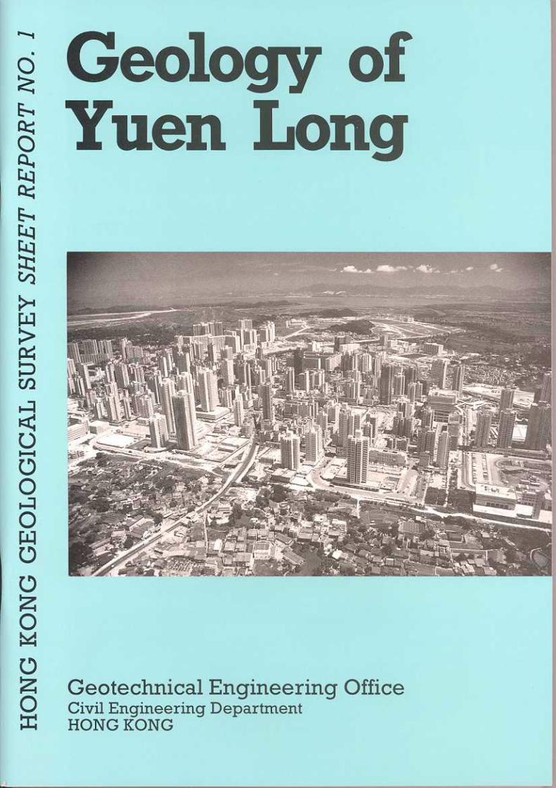
Cover: Oblique aerial viewof Yuen Long and Tin Shui Waiin 1987
This publication is available from:
Hong Kong Geological SurveyGeotechnical Engineering Office11fF Civil Engineering Building
101 Princess Margaret RoadHomantinKowloonHong Kong

This report specifically relates to the Designated Area, which is the part of the northwest NewTerritories defined by the Hong Kong Geological Survey in 1987 as possibly underlain by marble. Thegeology of the area is depicted on twenty sheets of the 1:5 000 Geological Map Series HGP5A andHGP5B. The 1:20 000 Geological Map Sheets 2 (San Tin), 5 (Tsing Shan) and 6 (Yuen Long), andMemoir No.3, Geology of the Western New Territories, also include information about the geology ofthe area covered by the report.
This report forms part of the published results of a programme of systematic geological mapping thatbegan in 1982. This work has greatly enhanced our understanding of Hong Kong's stratigraphy andstructure, and is establishing the geological database necessary for the continuing economicdevelopment of the Territory. The mapping programme is being undertaken by the Hong KongGeological Survey, which is a section of the Planning Division of the GCO. The section was led byMr P. J. Strange and the Division was under the direction of Dr A. D. Burnett during the mappingproject reported here.
The 1:5 000 scale geological survey of the Designated Area was conducted by Dr D. V. Frost of theBritish Geological Survey under a consultancy agreement between Hong Kong Government and theNatural Environment Research Council, United Kingdom. Dr Frost was assisted by Ms N. J. Darigo,Mr D.K.M. Yuen and Mr A.H.P. Chau of Dames & Moore (Hong Kong), and the project wasundertaken between May 1988 and April 1990. Prior to this, preliminary work in the Designated Areahad been carried out by Mr K. W. Lai and Dr R. L. Langford of the Hong Kong Geological Survey.
The Survey benefitted from the co-operation of many organizations and individuals. The co-operationof Dr L. J. Endicott and staff of Dames & Moore (Hong Kong), Acer Freeman Fox Ltd, Binnie &Partners, Fugro (Hong Kong) Ltd, Maunsell Geotechnical Services Ltd, Ove Amp & Partners (HongKong) Ltd, and Electronic and Geophysical Services Ltd is gratefully acknowledged.
This report and the accompanying map sheets will be of interest and value to earth scientists, engineers,planners, developers and educationalists.
A. W. MalonePrincipal Government Geotechnical EngineerApril 1992
3
Page
1
3
5
9
13
13
13
14
18
23
2323232525262627
27
29
29303030
3031
32
32
32
37
37
41
41
41
41
41
44
47
48
54
Chapter 1
Chapter 2
Chapter 3
Chapter 4
Chapter 5
Chapter 6
Chapter 7
Title Page
Foreword
Contents
Map and Report Series Notes
Introduction
Location and Physiography
Previous Work
The Designated Area Project
Outline of Geology
Sedimentary and Volcanic Rocks
Palaeozoic Rocks of the San Tin GroupClassification and DistributionY uen Long Formation
Long Ping MemberMa Tin Member
Lok Ma Chau FormationMai Po MemberTai Shek Mo Member
Mesozoic Sedimentary and Volcanic Rocks
Metamorphic and Igneous Rocks
Metamorphic RocksRegional MetamorphismThermal MetamorphismMetasomatism
Intrusive Igneous RocksGranitoid Rocks and Heat Generation
Structure
Granite Plutons
Volcanic Rocks
Folds
Faults and Joints
Superficial Deposits
Classification and Distribution
Clay Residues
Debris Flow Deposits
Alluvium
Marine Deposits
Estuarine Deposits
Karst
Reactivation of Karst Features
5
Page
56
56
56
56
Chapter 8 HydrogeologyInuoduction
Groundwater Characteristics
Water Quality
References 59
62
Index 67
Appendix
1
2
3
62
64
64
4
5
6
7
Abbreviated Borehole Logs
Classification of Zircons by Colour and Morphology
Heavy Minerals in Cavity Fill and Associated Sedimentsin the Marble of Yuen Long
Microfossil Determinations of Samples from the Carboniferous San Tin Group
Minerals from Insoluble Residues from Yuen Long Marbles
Heavy Minerals from Sandstones in the Yuen Long Area
Carbon 14 Dating of Quaternary Deposits in the District
65
65
66
66
List of TablesTable
10
2
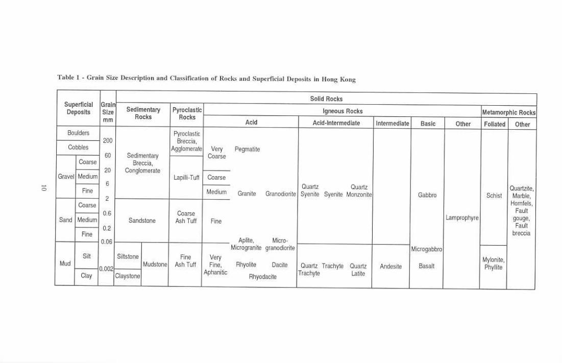
Grain Size Description and Classification of Rocks and Superficial Depositsin Hong Kong
Solid Rocks and Superficial Deposits of the District 19
11
12
3
4
15
2021
24
33
5
6
73435
36
38
8
9
6
Figure
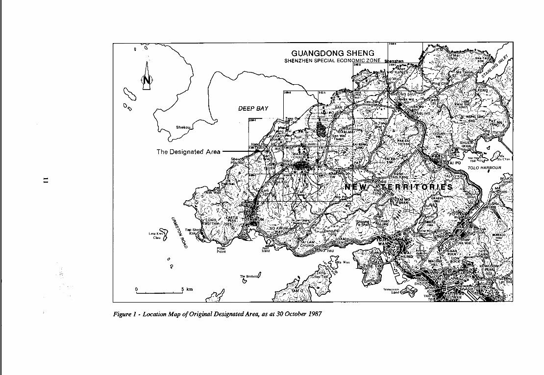
1 Location Map of the Original Designated Area, as at 30 October 1987
2 The Redefined Designated Area in the Northwest New Territories(Scheduled Area No.2)
Location of Boreholes (BGS) Drilled for the Marble Project
Generalised Solid Geology(a) Yuen Long(b) Lok Ma Chau
Generalised Section of the San Tin Group
Ribbon Section Showing the Structural Framework of the Designated Area
Main Structural Features of the District(a) Yuen Long(b) Lok Ma Chau
Marble/Granite Association in a Site Near Tin Shui Wai
Structure of the Long Ping Estate, Yuen Long

Page
39
40
1011
1213
14
42
43
44
15
45
16
1746
47
1850
19
51
20 52
2122
53
55
23
2457
58
Rose Diagram of Faults of the Yuen Long District
Graph Showing Frequency and Inclination of Joints in theMa Tin Road Borehole
Contours on the Base of the Superficial Deposits
Ribbon Section Showing the Superficial Deposits Typical of the District
Contour Map Showing the Base of the Alluvial Deposits Suggesting aPalaeogeography of Meandering Channels
Contours and Isopachytes of Superficial Deposits Overlying Marble ofSite YLTL 313 on the Yuen Long Industrial Estate
Generalised Thickness of Marine Deposits in the District
Generalised Rockhead Contours of the Carboniferous Strata around Yuen LongBetween Marble and Granodiorite Located at Site YLTL313,Yuen Long Industrial Estate
Karst Features on Part of Site YLTL 313, Wang Lok Street,Yuen Long Industrial Estate
Rockhead Contours and Section Showing a Doline Developed along theFaulted Boundary
Contour Map of the Top Karstic Surface of the Marble at Site YLTL 442adjoining Hop Hoi Street, Yuen Long
Cavity Infill Deposits from a Mazier Sample in BGS 2Large
Area of Soft Silt Formed at the Thrust Boundary Between the Mai Po andMa Tin Members of the San Tin Group. Site YLTL 446, Yuen Long
The Shan Poi River Catchment, Yuen Long
Schematic Model of Groundwater Flow Beneath Yuen Long
List of Plates
Plate
1 13
14
16
3
4 17
5
22
6 22
7
2526
27
8
9
10 27
112812
Yuen Long Looking South from the Industrial Estate
Fish and Duck Ponds Northeast of Fairview Park
Large Block of Karst Marble (inverted Ma Tin Member) Excavated from theRockhead at the LRT Site, Yuen Long
Marble Quarry near Shenzhen Showing Palaeokarst Scarp and Dip Topography.A Small Doline Depression on the Extreme Left is Filled with Superficial Deposits
Highly to Completely Weathered Metasiltstone of the Mai Po Member ShowingLiesgang Rings in Ferruginous Concretions; BGS 17, 52.90-53.90 m
Highly to Completely Weathered Metasiltstone of the Mai Po Member ShowingSecondary Growth of Manganese Dioxide (Pyrolusite); BGS17, 42.90-43.90 m
Marble From the Long Ping Member, Yuen Long Fonnation; BGS2
Marble From the Ma Tin Member, Yuen Long Fonnation; BGS3
Metasiltstone and Metasandstone of the Mai Po Member, Lok Ma Chau Fonnation;BGSll,112.55-117.50 m
Graphite Schist of the Mai Po Member, Lok Ma Chau Fonnation, with ProminentWhite Quartz Veins; BGS27, 51.10-54.75 m
Highly to Completely Weatherd Tuffaceous Siltstone with Clasts of Marble,Tin Shui Wai Member, Tuen Mun Formation; BGS8, 91.80-97.40 m
Interbedded Tuffite and Marble-bearing Breccia, Tin Shui Wai Member,Tuen Mun Fonnation; BGS18, 40.62-44.24 m
28
7
Page
29
29
48
48
13
14
15
16
Veined and Fractured Marble Closely Overlying Granodiorite; BGS9. 45.25-49.46m
Granodiorite Showing Stained Joints; BGS6. 22.66-26.17 m
Karst Features in Borehole Cores: Solution Feature Showing Feffilginous Staining
Karst Features in Borehole Cores: Solution Widened Joint Showing Fretted Surface
8
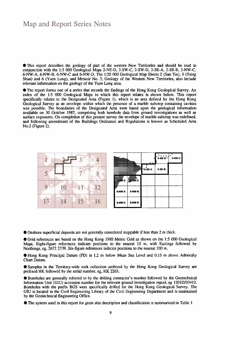
.This report describes the geology of part of the western New Territories and should be read inconjunction with the 1:5 000 Geological Maps 2-NE-D, 2-SW-C, 2-SW-D, 2-SE-A, 2-SE-B, 3-NW-C,6-NW-A, 6-NW-B, 6-NW-C and 6-NW-D. The 1:20000 Geological Map Sheets 2 (San Tin), 5 (TsingShan) and 6 (Yuen Long), and Memoir No.3, Geology of the Western New Territories, also includerelevant information on the geology of the Yuen Long area.
.The report forms one of a series that records the findings of the Hong Kong Geological Survey. Anindex of the 1:5 000 Geological Maps to which this report relates is shown below. This reportspecifically relates to the Designated Area (Figure 1), which is an area defined by the Hong KongGeological Survey as an envelope within which the presence of a marble subcrop containing cavitieswas possible. The boundaries of the Designated Area were based upon the geological informationavailable on 30 October 1987, comprising both borehole data from ground investigations as well assurface exposures. On completion of this present survey the envelope of marble subcrop was redefined,and following amendment of the Buildings Ordinance and Regulations is known as Scheduled AreaNo.2 (Figure 2).
~
.+. .' '2-NE-D~
2-SE-B
3-NW-C I
6-NW-A 6-NW-B I
6-NW-C 6-NW-D I
.Onshore superficial deposits are not generally considered mappable if less than 2 m thick.
.Grid references are based on the Hong Kong 1980 Metric Grid as shown on the 1:5 000 GeologicalMaps. Eight-figure references indicate positions to the nearest 10 m, with Eastings followed byNorthings, eg, 26722739. Six-figure references indicate positions to the nearest 100 m.
.Hong Kong Principal Datum (PD) is 1.2 m below Mean Sea Level and 0.15 m above AdmiraltyChart Datum.
.Samples in the Territory-wide rock collection archived by the Hong Kong Geological Survey areprefixed HK followed by the serial number, eg, HK 2263.
.Boreholes are generally referred to by the drilling contractor's number followed by the GeotechnicalInformation Unit (GIU) accession number for the relevant ground investigation report, eg 1201D/03412.Boreholes with the prefix BGS were specifically drilled for the Hong Kong Geological Survey. TheGIU is located in the Civil Engineering Library of the Civil Engineering Department and is maintainedby the Geotechnical Engineering Office.
.The system used in this report for grain size description and classification is summarized in Table 1
9
~
t'-..
~ ~
ti .c~
I.)
C)
c ~
>-
~
~
~
f.X)
~
~
Q..~
J
~
UJ
~
8 ...
~
~./!>
~
~ ~
~
.~'"
ro ~
Q
) ~
~
~
-0
.S
Q)
.~+
' ...
:g E
C
)O
J ~
~
.-it)
0 In Q
) §
0 ~
~
~
Q)
~
J::. U
. ~
§
I-~
~u
~
-~
?, g
a -~
~
tJ 0
..:.Q
(;>
~
0 ... ~
.~
~
11

UJ
~~~ (!)5
~
Z~
"i
w-
I~
~
cnz
~
0 "5
(!)~
~
Z-J
~
0 <
...
O
()UJ
-C
Cl.
... (!)cn
~
Zz
~«U
J-, :J~
~
(!)~
:I: 0')
cn ~
g
...
>-
~
~
« e
'""-~
;:
-'":t (I)
~J:!>
~,
a. '"
lIJ
~
lIJ ...
a ~
0 -,
z "'t:~
."i<
{ .~~
L.U
~
0::
Q
<{
op.o ~
0
til\ ~
L.U
",5,\0
~
-.J 1)1\
~
c. ~
:J
~
~
0 (Ii ~
~
L.U
"2
~
I ~
u ~
()
:, E
o;;; U
) ,
<1
-==
==
~J
0 ~,
0 !?o/.;>
~"rZ
;
f
12
'" -~
--~
"