02-2020 web mapping service (wms) on-demand request02-2020 . web mapping service (wms) on-demand...
TRANSCRIPT
02-2020
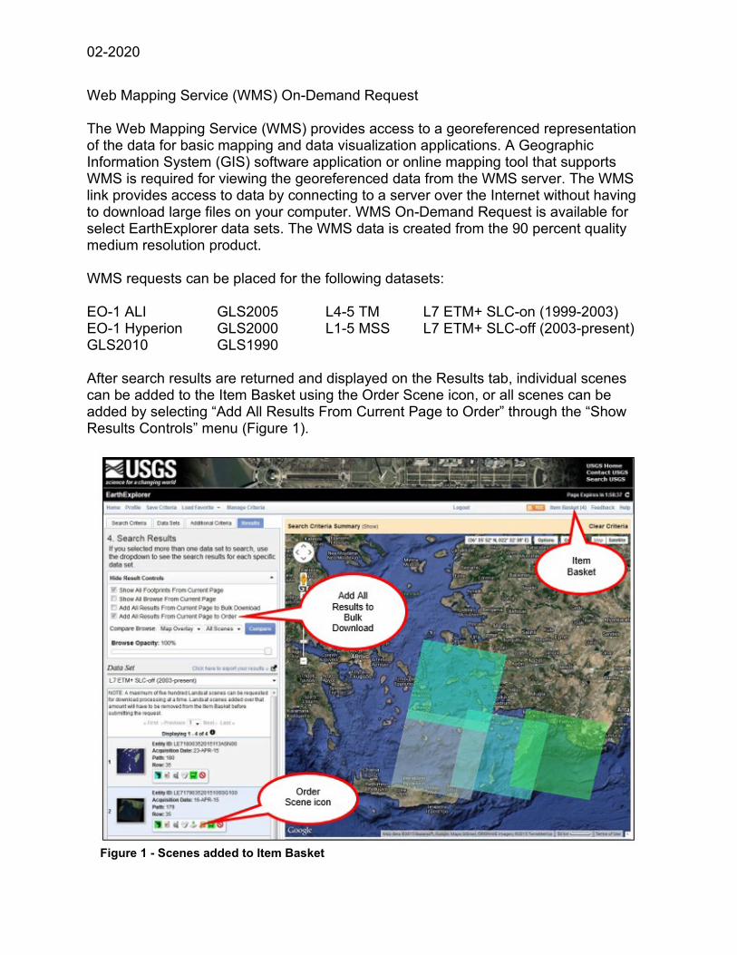
Web Mapping Service (WMS) On-Demand Request The Web Mapping Service (WMS) provides access to a georeferenced representation of the data for basic mapping and data visualization applications. A Geographic Information System (GIS) software application or online mapping tool that supports WMS is required for viewing the georeferenced data from the WMS server. The WMS link provides access to data by connecting to a server over the Internet without having to download large files on your computer. WMS On-Demand Request is available for select EarthExplorer data sets. The WMS data is created from the 90 percent quality medium resolution product. WMS requests can be placed for the following datasets: EO-1 ALI GLS2005 L4-5 TM L7 ETM+ SLC-on (1999-2003) EO-1 Hyperion GLS2000 L1-5 MSS L7 ETM+ SLC-off (2003-present) GLS2010 GLS1990 After search results are returned and displayed on the Results tab, individual scenes can be added to the Item Basket using the Order Scene icon, or all scenes can be added by selecting “Add All Results From Current Page to Order” through the “Show Results Controls” menu (Figure 1).
Figure 1 - Scenes added to Item Basket
02-2020
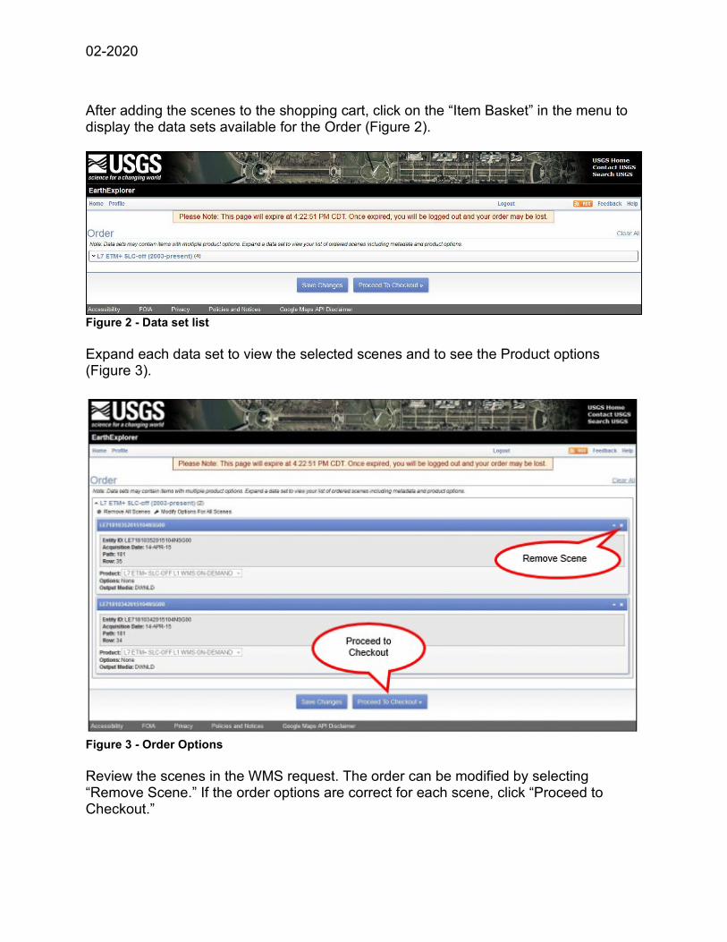
After adding the scenes to the shopping cart, click on the “Item Basket” in the menu to display the data sets available for the Order (Figure 2).
Figure 2 - Data set list Expand each data set to view the selected scenes and to see the Product options (Figure 3).
Figure 3 - Order Options Review the scenes in the WMS request. The order can be modified by selecting “Remove Scene.” If the order options are correct for each scene, click “Proceed to Checkout.”

02-2020
The Order will show the data set and number of scenes. Click “Submit Order” to submit the WMS request for processing (Figure 4).
Figure 4 - WMS On Demand Submittal The Order Summary page shows the order number and displays a list of scenes (Figure 5). Click “Return to EarthExplorer” to conduct another search.
Figure 5-– WMS Order Summary

02-2020
A USGS Online Order Confirmation email will be sent with the order details (Figure 6).
Figure 6 - WMS Order Confirmation Email When compilation of the order is complete, an email notification that contains the WMS link is delivered (Figure 7). The link can be copied into a GIS software package or mapping tool to access the data. (See below for details on using the WMS link.) Please note that the link is not intended to work in a basic web browser or as a download. NOTE: The WMS link will be available for two weeks. If the file is not accessed during this time, it will need to be re-ordered.

02-2020
Figure 7 - Email notification with WMS Link Reminder: The USGS WMS server provides access to a georeferenced representation of the data for basic mapping and data visualization applications, but does not provide access to the actual data files. If more complex analysis is required, return to EarthExplorer to download the Level 1 data products. Viewing the WMS Link A GIS software application or online mapping tool that supports WMS is required for viewing the WMS georeferenced data. A web search for tutorials for a software package along with the version will provide the most useful information for a specific software application. A web search for “online mapping tool wms” or “web map service open source’” will provide a variety of options that support WMS. The example shown below depicts how to use a WMS link in ESRI ArcMap. Other GIS packages may provide similar capabilities. NOTE: The USGS does not endorse or support specific software packages. Any usability questions should be directed to the specific software vendor.

02-2020
To add the WMS layer to ArcMap, select the “Add Data” function (Figure 8).
Figure 8 - Add Data Navigate to “GIS Servers” in the “Add Data” dialog box (Figure 9).
Figure 9 - Add GIS Servers

02-2020
In the ArcMap GIS Servers dialog box, select “Add WMS Server” then click “Add”. (Figure 10).
Figure 10 - Add WMS Server

02-2020
The “Add WMS Server” dialog box allows you to insert the WMS link received in the email into the “URL” field. Paste the WMS link into the URL field and click “Get Layers” (Figure 11).
Figure 11 - Add WMS Server dialog box

02-2020
A list of scenes is displayed in the WMS request. Click “OK” (Figure 12).
Figure 12 - Add Layers in WMS Server dialog box
02-2020
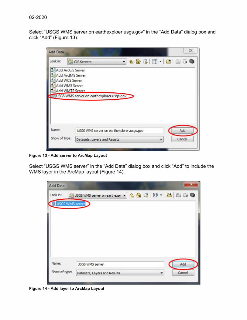
Select “USGS WMS server on earthexploer.usgs.gov” in the “Add Data” dialog box and click “Add” (Figure 13).
Figure 13 - Add server to ArcMap Layout Select “USGS WMS server” in the “Add Data” dialog box and click “Add” to include the WMS layer in the ArcMap layout (Figure 14).
Figure 14 - Add layer to ArcMap Layout

02-2020 Figure 15 is an example of the WMS layer in the ArcMap Table of Contents dialog.
Figure 15 - Example WMS Scenes displayed in the ArcMap Zoom in to view the scenes in the WMS link.