046 thinking spatial networks today:
TRANSCRIPT

SSS10 Proceedings of the 10th International Space Syntax Symposium
046
Thinking spatial networks today: The ‘Vastu Shastra’ way
Priyambada Das Space Syntax, London [email protected] Prachi Rampuria Paul Davis & Partners, London [email protected]
Abstract
This paper is based on the conjecture that, often successful, well-functioning cities or urban areas are the outcome of a heuristic approach to design - an accumulation of trial and error of spatial networks over centuries. Such has been the case of traditional Indian cities like Madurai, one of the oldest continuously inhabited cities in the world; and Jaipur, which was built in the beginning of eighteenth century.
A common denominator for the inception of these cities has been the principles of Vastu Shastra, the ancient Indian science of town planning and architecture, aimed at achieving a balance among functionality, bioclimatic design, religious and cultural beliefs (Ananth, 1998). These Vastu principles having survived centuries of socio-economic, political and cultural changes, in the form of these cities, embed within themselves the essential DNA of an efficient and robust structure for settlements. However, instead of learning from such cities, planning practitioners and academics in the discipline have been incurious about the reasons of overwhelming resilience of these cities. Decoding this DNA could potentially give us a deeper understanding to the design of effective and resilient spatial network.
Therefore, taking Jaipur and Madurai as empirical case studies, this paper aims to decipher their DNA, compare and contrast them in form of a framework of principles that have contributed to the resilience of their spatial networks, over centuries. This is done using various syntactic techniques, which allows us to objectively analyse spatial networks. Understanding the commonalities and differences between spatial structures, in comparison to the current best practice, the paper concludes its transferability in current urban context.
Keywords
Spatial network, decoding DNA, Vastu Shastra, resilience, space syntax.
1. Introduction
Vastu Shastra is one of the oldest Indian ideology based sciences, which has been established for six thousand years. The overriding theme of Vastu is a connection between functionality, auspiciousness and nature wherein one keeps the other alive (Ananth, 1998). The merits of its
P Das & P Rampuria Thinking spatial networks today: The ‘Vastu Shastra’ way
46:1

SSS10 Proceedings of the 10th International Space Syntax Symposium
counter parts like Feng Shui and Geomancy are already well known to the western world1. It is hard to capture Vastu Shastra in a simple definition, as people have approached it in many different ways:
‘‘Vastu is the art of living in harmony with the land, such that one derives the greatest benefits and prosperity from being in perfect equilibrium with Nature ’’(Acharya, 1981, p.14).
“Vastu Shastra is a highly refined method of creating a living space which is a miniature replica of the cosmos as perceived by the Vedas2. It is about emulating the attributes of the cosmic space, about bringing the divine sentinels of cosmic directions into our homes, about creating harmony by creating a living environment where the forces of nature are balanced and at peace with each other”(Gupta, 1995, p.20).
The metaphysical and philosophical nature of Vastu Shastra was rooted since the ancient times and had a significant importance in the Indian way of living. For centuries, Indian people relied on Vastu Shastra to design cities and settlements, builds homes, temples, and palaces. Historically, it has had great contribution towards the environmental design and town planning of many cities that still flourish even today. Having survived centuries of socio-economic, political and cultural changes, these cities embed within themselves the essential DNA of an efficient and robust structure for settlements.
However, most of the planning practitioners and academicians in India are incurious about the overwhelming resilience of cities designed according to Vastu. Presently, Vastu is largely regarded as a pseudo-science, as its theories are based on a complex system of philosophy, astrology, intuition and superstition. They can only be partly explained by modern scientific principles. But we feel this is a rather pessimistic view towards the whole subject, and this ancient science might deserve more positive attention than merely calling it backward, ancient and superstitious.
2. Research aims and objectives
Therefore, our research aim is to analyse the structure of cities designed according to Vastu, using the syntactic methods of space syntax. This would allow us to objectively decipher the spatial structure built on the tenets of this ancient ideology based science, and consequently understand its relevance in the current urban context.
To achieve our aim, therefore, the first objective of this research is to understand the ideologies and concepts of Vastu in relation to urban design and way of life. Furthermore, their spatial implications on design of selected case examples are studied.
The second objective is then to empirically assess the spatial structure of selected case examples using space syntax techniques. This would help us decipher the genetic code of spatial structures based on Vastu that have evolved and expanded ever since.
Finally, the third objective is to study the evolution of the selected case examples over time to understand the notion of resilience that was embedded in their very spatial network.
3. Methodology
Based on the objectives, the methodology and contents of the research is divided into three parts. The first part introduces Vastu Shastra, its ideologies, origins, and the fundamental principles in relation with urban design. As mainly two schools of Vastu Shastra flourished in ancient time, this research includes, as case examples; the of Madurai, based on Dravidian (south Indian) school of Vastu Shastra and Jaipur, which was designed according to the Nagara (north Indian) school of Vastu Shastra. Having survived centuries of socio-economic, political and cultural changes these cities bear testimony of resilience and adaptability of spatial structure over time. Madurai is one of the world’s
1As per ancient scriptures, Chinese monks carried Vedic knowledge with them, which gradually evolved as FengShui 2Oldest scripture of Hinduism
P Das & P Rampuria Thinking spatial networks today: The ‘Vastu Shastra’ way
46:2

SSS10 Proceedings of the 10th International Space Syntax Symposium
oldest continuously inhabited cities and Jaipur being built in the 18th century still continues to thrive and expand.
Having gained an understanding of the application of Vastu rules on the spatial structures for both cities, the second part uses syntactic methods such as spatial accessibility analysis, multi-scale analysis, block size analysis and intelligibility study to empirically assess their spatial structures. Spatial accessibility analysis helps to find out the most chosen or integrated routes within a system, whereas multi scale analysis gives understanding of movement across scales. Block size analysis examines the permeability of urban system and intelligibility study shows legibility of the urban form. It should be noted, with British invasion, the Vastu schools gradually dissolved and after a point in time, these cities were no longer designed according to Vastu principles. Therefore, the spatial extent of the case examples studied in this section is limited to the physical extent of the cities that was designed as per Vastu.
The third part of the research tries to find out how these historic cores perform in present urban context. It uses spatial model of the entire city and examines importance of the historic core by looking at its integration and choice measures. The above-mentioned steps will help us to gain a better understanding of the very first conjecture regarding heuristic approach to design.
4. Ideologies and principles of Vastu Shastra
In Vastu Shastra, the under structure of any design concept emerged out from a philosophic frame of the phenomena of Existence, Space and Time. The phenomenon of Existence is underpinned by the philosophy that all things and their existence are inter-connected. So, the existence of one affects the other. The phenomenon of Space is conceptualized as a dynamic element made of energy particles, wherein the main aim is to create an environment that is in harmony with this subtle energy; and lastly, the ‘notion of Time with regard to cosmos and human life have been explained to coalesce all processes and movements of the universe’(Parikh, 2008, p.28). Based on these ideologies, the built form was designed to be in harmony with the forces of the universe.
According to Parikh and Danielou, Hindu philosophy, its origin, has always maintained that the interpretation of all three phenomenon in continuum leads to an intrinsically dynamic worldview and that they are absolutely essential in order to understand the Indian view of the universe and the forces that affect human life. Any aspect of the manifest world exists in space, the terminologies being mutually definitive. Time is a dimension of space and therefore inseparable from it. ‘Space and Time together form a continuum that regulates each form of existence’ (Parikh, 2008, p.35). Therefore, it can be said that these are not independent phenomenon, but part of a greater continuity, where a seamless cycle of one transforming the other goes on eternally. This makes the continuum of Existence, Space and Time the philosophical frame of Vastu Shastra that finds direct manifestation in the art of urban design and architecture.
The interaction between the three basic phenomena of Existence, Space and Time were also considered to be deeply rooted in the way of life and moral values of the Indian people. According to Parikh (2008, p.47) ‘every action of the people reveals their response to the Hindu philosophy based on the interaction of these basic phenomena’. This makes it clear that the spatial organizational principles of Vastu Shastra ensured that the design of physical spaces responded to the cultural values and way of life of the people. Through literature and experts, it can be gathered that, these spatial organizational principles, based on the interaction of the three phenomena, can be expressed through four key concepts; that informed layout and consequently, the structure of cities (Parikh, 2008; Danielou, 1964; Radhakrishnan, 1951; Vatsyayan, 1991):
1. Co-existence of systems and relative wholeness: Stemming from the individual identity of the underlying ideologies and their seamless continuity, Vastu believes that the components of the physical environment also needs to be complete entities in their context; creating individual centres in continuum wherein each centre is defined by several other sub-centres. This again contains smaller sub-centres, each connected to one another in order to reflect the order of the cosmos. Thus, connectivity and relative wholeness become one
P Das & P Rampuria Thinking spatial networks today: The ‘Vastu Shastra’ way
46:3

SSS10 Proceedings of the 10th International Space Syntax Symposium
of its organizational principles and was applied by the use of Vastu Purusha Mandala3 (Figure 1a). In Hindu literature where the relationship between the Mandala and urban planning is explored, it is suggested that the sacred geometry of the Mandala is essential to establish a secure claim within an active landscape.
2. Individuality within a group: As much as all forms of existence and space can be understood in terms of a system of concentric wholes, centres and sub-centres, each of them have a degree of centeredness; implying independent identities. ‘They have their own regulating systems and specific characteristics that are different from others and make an individual statement’ (Parikh, 2008, p.55). But, no matter how distinct, each element forms a part of each other. The underlying meaning in terms of Vastu Shastra therefore implies how individual buildings or parts of a larger city, even though having an independent identity, need to coexist harmoniously in order to contribute to the overall greater identity of the town or city; making it another of its key organizational principles.
3. Coexistence of extremes and celebration of junctures: All conceptions of Space and Existence are based on the principle of bipolar manifestation, wherein the extremes are considered to be merely different aspects of the same phenomenon, working in a intercommunicative unity and forming a continuum over Time. One is dependent on the other for its existence and effectiveness. Maintaining a balance between the extremes was considered crucial for all aspects of life, including built form. Since Space was believed to be made of energy, this coexistence related to the five kinds of energies namely, ether, air fire, water and earth - the ‘Panchbhootas’. The perfect environment according to Vastu is one where there is a balance of all the energies enhancing mutual existence. This unification of relationships between extremes in the built environment automatically puts a lot of importance to the design of transitions, junctures and thresholds.
4. Timelessness of space: As per the experts, Vastu believes in the concept of multi-layering of Time reflected in the Space as changes within a spatial frame, where the ‘resultant space evolves its independent identity though carrying the shadows of the original one’ (Parikh, 2008, p.67). This concludes adaptability of space with layering of time as one of the organizational principles. This principle works in conjunction with the Vastu belief of being sensitive to the natural context and using the resources of the area sustainably in order to be in tune with the space time continuum.
The application of the above in shaping of the urban form and structure of the cities of Jaipur and Madurai is explained briefly as below.
5. Application of Vastu principles in Madurai
The actual chronology of Madurai’s early existence is impossible to construct for lack of direct evidence. However, its roots can be traced back to the 1st millennia B.C and is associated with the Pandyan dynasty. Simply put, the city’s urban form is a series of concentric streets about a central temple complex (Figure 1d). ‘Nowhere visible as a whole, the organization is experienced only gradually over time’ (Smith, 1969, p.11). According to Smith (1969), ‘what is striking is the use of a fairly simple underlying geometry to express important attitudes towards collective dwelling’. But in Vastu terms this would have needed to be the adaptation of the ‘Vastu-Mandala’ and by extension the ideologies of the Hindu philosophy.
In terms of urban layout, the strict geometry of the mandala does not necessarily translate into a literal ground plan. As per the experts, the Vastu Mandala diagram is meant to explain rather than represent. Madurai is not a city having a rigid grid pattern as its urban form; the basic pattern ‘here is distorted’ (Smith, 1969, p.15). This distortion was the response to the natural landscape and topographical features suggested in the Tiruvilaiyadal Purana’s4 description of Madurai’s early fortifications. Its interpretation by Venkatarama Ayyar suggests that the walls of the fort were
3A symbolic diagram representing model of the Universe 4Ancient Hindu script
P Das & P Rampuria Thinking spatial networks today: The ‘Vastu Shastra’ way
46:4

SSS10 Proceedings of the 10th International Space Syntax Symposium
constructed, as the natural topography of the land would permit. ‘With the river on one side, mechanical symmetry of the layout for the walls would have to be purchased at a very high price’ (Smith, 1969, p.26). The plan thus included several deflections and zigzag shape.
Figure 1a-d: (a) Vastu Purusha Mandala– Brahman (Hindu God) in the form of a Purusha (cosmic man or person) inside the model of the Mandala, a square representing the universe (Source: Murugan et al., 2007); (b) Mandala being used for various configurations and layout illustrating Brahman as the nucleus of Mandala (Source: Gupta, 1995); (c) Various town plans following the notion of Mandala (Source: Acharya, 1980); (d) Historic city of Madurai (Source: Smith, 1969)
However, as per Smith, topologically significant interrelationships of parts were kept intact. The intricate network of connected pathways within the larger divisions of the city have many places where the narrow streets open up and small neighbourhood centres exist, much quieter than the bustle of the main arteries. This quality of connectivity and relative wholeness is also expressed in the festival processions, which take place in the concentric streets and thus delineate the Mandala over the course of the year. Symbolic of its identity, it ‘reconfirms the underlying form and its use as a principle reference for the community’s sense of itself in space and time’ (ibid).
According to Smith and Ayyar, the predominant central core, maintains an unusual quality of presenting itself as a ‘single integrated phenomenon’. Yet, Madurai has a rich diversity within it for local interventions and distortions. ‘The direct involvement with a place at human scale is critical to the understanding of how the principle of ‘individuality within a group’ was reflected through the urban form. The residential enclaves retain an almost village like character. This process of city buildings as village aggregation became a method of combining disparate groups each retaining its local identity within the larger whole. Just as the Mandala is locked in place by specific deity allocations, so Madurai exhibits the analogous distribution of trade groups, giving a ‘cross-grain identity’ to the pattern and enhancing the sense of both individuality and orientation within the urban form.
The larger streets, the main corridors of the city, have their own character. Their gentle meandering softens the momentum of movement along them. This relaxation occurs especially at the corners of the large concentric avenue, which are demarcated for special events or rendered of a special character using physical elements such as a tree to create a distinct sheltered environment. This can be directly related to the principle of sensitive treatment of transitions, nodes and junctures as part of the city building process.
P Das & P Rampuria Thinking spatial networks today: The ‘Vastu Shastra’ way
46:5

SSS10 Proceedings of the 10th International Space Syntax Symposium
Having a brief understanding of the adaptation of the principles and ideologies of Vastu on the urban form of Madurai, we now move to the city of Jaipur.
6. Application of Vastu principles in Jaipur
The principles of being sensitive to the natural context and its natural resources to guide the urban form can be seen in the city of Jaipur as well (Figure 2a). As per the experts, the land being flat, the layout of the streets is fairly regular and their orientation is in accordance to the ‘prevalent winds and light of the sun and moon’ to ensure the ‘purity of streets’ (Acharya, 1981, p.45). The dimensions and form of the Mandala can also be seen to have been affected by the presence of natural features like hills, woodlands and lakes within the site.
Figure 2a-c: (a) The site for Jaipur with its natural features, ascertaining of the cardinal direction, overlaying of Mandala and modification of Mandala to accommodate the natural features; (b) Individual wards or Chawkris of Jaipur given a specific name akin to their identity and streets given specific names according to their functions (Source: Sachdev, 2002); (c) City of Jaipur, where the superimposed Mandala is divided and subdivided by the street layout to form a hierarchy of wards, neighbourhoods, blocks, and individual buildings, each being a whole yet part of a larger whole. (Source: Parikh, 2008)
A structure of relative wholeness is observed in the planning of the city of Jaipur. Jaipur was divided into nine squares (Paramasiya Mandala) by streets, creating large city wards (Sachdev, 2002). These were then divided into neighbourhoods made up of cluster of houses that led to individual houses. The buildings were designed as a set of rooms around a courtyard, which was the centre of all activities. Thus the whole city was designed in terms of ‘cells within a set of cells’ (ibid). All individual units were whole yet linked to the larger whole by the network of streets and open spaces. This connected spatial network was in response to the Vastu principle that it is essential to maintain ‘satatya’ or continuum in the ‘anukram’ or hierarchy of streets and open spaces in accordance to how the supreme creator has made the universe where all things are connected to one another.
According to Vastu expert Arun Naik, just as each individual God is given their own identity and recognition in the Mandala; Jaipur’s urban form considers the distribution of landmark elements like the temple, palace, and city gateways to ensure individuality in the overall city fabric. They not only served as landmark in themselves but also gave a distinctive character to the areas around. Most of them were overlaid with religious and spiritual meaning to ensure that they were respected by the generations. The same was done in the city of Madurai through the use of Gopurams5. Individual
5monumental tower at the entrances of Meenakshi Amman Temple
P Das & P Rampuria Thinking spatial networks today: The ‘Vastu Shastra’ way
46:6

SSS10 Proceedings of the 10th International Space Syntax Symposium
wards or ‘chawkris’ were given specific names akin to their identity. Similar to the city of Madurai, often they were named suggestive of the kind of activity that the street or open space was associated with, and by extension in relation to the occupation or trade that the community was associated with within a particular part of the city. It should be noted the Vastu principles were applicable at all scales ranging from the city’s spatial network to the detailed design of streetscape, buildings and architecture. However, for the purposes of this paper we are more concerned with the application of Vastu on shaping of the city’s overall spatial network.
7. Analysing spatial structure of Jaipur and Madurai
Previous section shows how sacred ethos of Vastu led to certain geometry or spatial order in Madurai and Jaipur. It will be interesting to understand beyond cosmological connotation how these cities were experienced and used by the inhabitants. Therefore, this part of paper reflects on spatial structure of the cities that resulted from specific ordering of space. This research attempts to decode the DNA of these two cities by answering the following questions. How people used to navigate in the spatial system? How land use or distribution of activities was influenced by such movement pattern? How parts and whole correspond to each other? As design of cities often mirrors how a society works, by analysing the spatial structure this research also aims to gain some insight into the former social system. It tries to find out how social hierarchy was manifested in the spatial structure. And how positioning of important urban elements within the spatial network reflect the then social system?
Spatial accessibility analysis of Madurai (Figure 3) shows, though Meenakshi Amman Temple is located at the core of concentric streets, it is not the most integrated6space in the system. Instead South Masi Street gets highlighted as the most integrated space in the city. South Veli Street also possesses high integration value.
Figure 3: Spatial accessibility _ normalised integration, Madurai (Source: Author)
Multi scale analysis of NACh_n and NACh_R800 (Figure 4) illustrates among four concentric streets Masi Street is the most often chosen7 route for both local and global movement. The outermost Veli Street is mostly preferred at global scale, though East and South part of Veli Street show high choice
6‘Integration is a normalized measure of distance from any space of origin to all others in a system’. It shows how close the space is to all other spaces.(source: http://otp.spacesyntax.net/term/integration/) 7Choice represents ‘how likely it is to be passed through - on all shortest routes from all spaces to all other spaces in the system.’ (source: http://otp.spacesyntax.net/term/choice/)
P Das & P Rampuria Thinking spatial networks today: The ‘Vastu Shastra’ way
46:7

SSS10 Proceedings of the 10th International Space Syntax Symposium
value even at local scale. Also, East Chitrai Street adjacent to Pudhu Madapam (old market) and West Avani Moola Street are well chosen for global movement. The most interesting finding of this analysis is the correlation between choice value and commercial activity. Overlapping of highly chosen routes (NACh value greater than 1.2) on current land use plan shows, majority of the city’s commercial activity has flourished along these routes. One can also argue that scale of movement has some influence on the character of trade that developed along the streets. Clustering of trade groups along specific streets, such as cloth merchants in South and East Chitrai Streets, paper merchants in East Avani Moola Street, goldsmith and jewellers in South Avani Moola Street and grain merchants in East Masi Street supports this fact (Smith, 1969). Such distribution not only reflects the notion of ‘individuality within a group’ but also portrays how caste system8was manifested in the spatial layout.
Figure 4: Multi-scale analysis, Madurai (Source: Author)
Presence of Gopuram or monumental tower at the entrances of Meenakshi Amman Temple provides a good sense of orientation in the city. The question remains, whether spatial layout also contributes in legibility of the city. Or how intelligible the city form is? Figure 5a shows Madurai has an intelligibility9 value of 0.159 which implies it is not very easy to interpret the whole system from its parts. In other words, if we ignore the presence of ‘Gopuram’, the city layout does not give enough clues for orientation. Smith’s narrative (1969, p.65-66) makes this argument even stronger, ‘...major streets and axes are not acknowledged with uniform facades or controlled vistas.....There is nowhere within the public realm that one gets an overall view of the city’s layout....The bends in the streets hide their extent; small streets radiating from the gopurams twist and turn...Madurai unfolds its secrets only through moving rather than stationary encounter. It is true experiential space in Choay’s terms...the city diagram is not itself an object of attention....’
8The caste system refers to classification of people into different hierarchy according to their occupation 9‘Intelligibility is calculated by correlating connectivity with integration at the infinite radius...’ (source: http://otp.spacesyntax.net/term/intelligibility/)
P Das & P Rampuria Thinking spatial networks today: The ‘Vastu Shastra’ way
46:8

SSS10 Proceedings of the 10th International Space Syntax Symposium
Figure 5a-b: (a) Scatter plot of integration and connectivity, Madurai (Source: Author); (b) Scatter plot of integration and connectivity, Jaipur (Source: Author)
Cities designed according to Vastu principles followed certain measuring system as prescribed in the ancient script of Manasara. ‘Danda’ and ‘Hasta’10 were the units of measurement for town planning in India (Funo et. al., 2002). It will be interesting to find out which type of urban grain resulted from such measuring system. Block size analysis of Madurai’s historic city (Figure 6a) illustrates majority of blocks have perimeters ranging from 200m to 400m. The next most common range of perimeter lies within 400m to 600m. And this indicates the system is fairly permeable (possible to cover in 5-6 minutes) and therefore convenient for pedestrian movement.
Figure 6a-b: (a) block size analysis, Madurai (Source: Author); (b) block size analysis, Jaipur (Source: Author)
However, when important city elements were superimposed on spatial model of the city, some degree of randomness were observed in their syntactic values11. In contrast to Karimi’s study (2012, p.46) which shows correlation between importance of city elements and their respective position in the spatial structure; example of Madurai illustrates syntactic value of the elements do not necessarily reflect their importance in society. And the probable reason behind such deviation is, both Iranian and English old cities have evolved organically with time, whereas, Madurai emerged from the unique form of Mandala, which contains metaphysical meaning. As the city depicts macrocosmic notion of ‘space time and existence’ through its physical form, location of many city elements was predetermined.
City Elements Name NAInt_n Temple Madanagopalasami Temple 1.4 Kings Palace Tirumala Nayak Palace 1.39 Market/Entrance hall to temple Pudu Mandapam 1.37 Temple Perumal Temple 1.36
10One Danda = 4 Hasta = 6 Feet (approximately) 11‘…calculated by averaging the values of the lines that are parts of these elements or adjacent to them’ (Karimi, 2012, p .45)
P Das & P Rampuria Thinking spatial networks today: The ‘Vastu Shastra’ way
46:9

SSS10 Proceedings of the 10th International Space Syntax Symposium
Temple Meenakshi Sundaresvarar Temple 1.31 Market Central Market 1.21 Water tank Perumal Temple Teppakulam 1.11
The above table shows though Meenakshi Sudaresvara Temple is the most significant city element it is not located at the most integrated part of the system. Whereas Kings Palace, which can be regarded as subordinate to the temple, both according to caste hierarchy and its influence on the society; is located in a position with higher integration value. Similarly, Madanagopalasmi Temple and Perumal Temple though less important than Meenakshi Sundaresvara Temple, have better integrated position within the system. Pudu Mandapam, the old market place which is also associated with some important religious ceremony, is thus located in the vicinity of the temple, instead of at the most integrated part of the system.
Deciphering spatial structure of Jaipur, which was built in a later stage than Madurai, will give us better understanding of Vastu principles. Comparison between the spatial structures of these two cities will also demonstrate how Vastu principles were applied or modified over time.
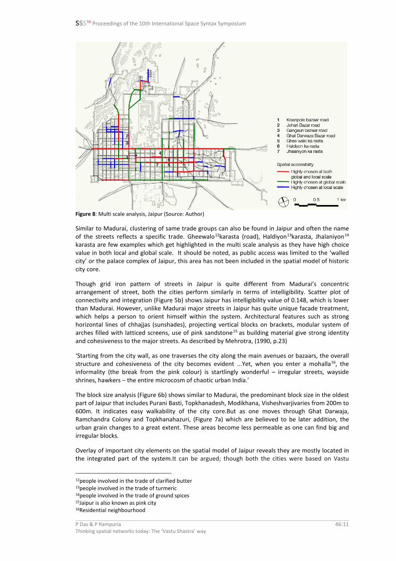
Spatial accessibility analysis of Jaipur (Figure 7) shows the busiest street in the city which connects Chandpole Darwazaa (gate) on the West to Surajpole Darwazaa on the East has the highest integration value. Along this street, which was a long established route from ancient times, many markets such as Chandpole Bazar, Tripolia Bazar, Ramganj Bazar, Surajpole Bazar have flourished. As expected, multi scale analysis of NACh_n and NACh_R400 (Figure 8) reveals this street has high choice value both at local and global scale. Roads perpendicular to this main street also get highlighted in this analysis. For example Kisanpole Bazaar road, Johari Bazar road and Gangauri bazaar road are highly chosen for both global and local movement, GhatDarwaza Bazar road is chosen for local scale movement.
Figure 7a-b: (a) Spatial accessibility _normalised Integration, Jaipur (Source: Author); (b) Different wards of Jaipur (Source: Author)
P Das & P Rampuria Thinking spatial networks today: The ‘Vastu Shastra’ way
46:10
SSS10 Proceedings of the 10th International Space Syntax Symposium
Figure 8: Multi scale analysis, Jaipur (Source: Author)
Similar to Madurai, clustering of same trade groups can also be found in Jaipur and often the name of the streets reflects a specific trade. Gheewalo12karasta (road), Haldiyon13karasta, Jhalaniyon14 karasta are few examples which get highlighted in the multi scale analysis as they have high choice value in both local and global scale. It should be noted, as public access was limited to the ‘walled city’ or the palace complex of Jaipur, this area has not been included in the spatial model of historic city core.
Though grid iron pattern of streets in Jaipur is quite different from Madurai’s concentric arrangement of street, both the cities perform similarly in terms of intelligibility. Scatter plot of connectivity and integration (Figure 5b) shows Jaipur has intelligibility value of 0.148, which is lower than Madurai. However, unlike Madurai major streets in Jaipur has quite unique facade treatment, which helps a person to orient himself within the system. Architectural features such as strong horizontal lines of chhajjas (sunshades), projecting vertical blocks on brackets, modular system of arches filled with latticed screens, use of pink sandstone15 as building material give strong identity and cohesiveness to the major streets. As described by Mehrotra, (1990, p.23)
‘Starting from the city wall, as one traverses the city along the main avenues or bazaars, the overall structure and cohesiveness of the city becomes evident ...Yet, when you enter a mohalla16, the informality (the break from the pink colour) is startlingly wonderful – irregular streets, wayside shrines, hawkers – the entire microcosm of chaotic urban India.’
The block size analysis (Figure 6b) shows similar to Madurai, the predominant block size in the oldest part of Jaipur that includes Purani Basti, Topkhanadesh, Modikhana, Visheshvarjivaries from 200m to 600m. It indicates easy walkability of the city core.But as one moves through Ghat Darwaja, Ramchandra Colony and Topkhanahazuri, (Figure 7a) which are believed to be later addition, the urban grain changes to a great extent. These areas become less permeable as one can find big and irregular blocks.
Overlay of important city elements on the spatial model of Jaipur reveals they are mostly located in the integrated part of the system.It can be argued; though both the cities were based on Vastu
12people involved in the trade of clarified butter 13people involved in the trade of turmeric 14people involved in the trade of ground spices 15Jaipur is also known as pink city 16Residential neighbourhood
P Das & P Rampuria Thinking spatial networks today: The ‘Vastu Shastra’ way
46:11

SSS10 Proceedings of the 10th International Space Syntax Symposium
principles, design of Madurai gave more importance to the metaphysical aspects, whereas Jaipur shows a more rational approach while applying Vastu principles. This in turn supports our initial hypothesis of heuristic approach to design. It can be conjectured trial and error over centuries, learning from Madurai led to a more logical and improvised version of Vastu application in Jaipur. The similar opinion is found in Smith’s writing, (1969, p.84)
‘The pattern of Madurai seems a less obvious but more interesting interpretation of the tradition represented by the Shastras. The later date of city’s17 layout and the existence there of a celebrated astronomical observatory, perhaps suggest an emerging new world order, with its own interpretation of the cosmos.’
City elements Name NAInt_n Temple Laxmi Narayan Temple 2.08
Public open space ChotiChaupar18 1.88 Public open space Badi Chaupar 1.85 Palace of the Winds19 Hawa Mahal 1.63
Entrance gate to city palace complex Sireh Deori Gate 1.63
8. Relevance of historic cores in present urban context
Spatial model of present day Madurai (Figure 9a) shows the historic city core is still an integral part of the whole system. It gets highlighted as the most integrated part of the spatial structure. Spatial accessibility analysis (Figure 9b) illustrates South and East Masi Street are well chosen for global movement. Veli Street also has high choice value. Both the factors help to thrive the commercial activities along these streets while keeping heavy traffic flow away from the main temple precinct.
Figure 9: Spatial accessibility analysis, present day Madurai (Source: Author)
17Reference of Jaipur 18Chowk, used for public gathering 19Five storey high structure from where royal women used to watch day to day events or royal processions happening on the street
P Das & P Rampuria Thinking spatial networks today: The ‘Vastu Shastra’ way
46:12
SSS10 Proceedings of the 10th International Space Syntax Symposium
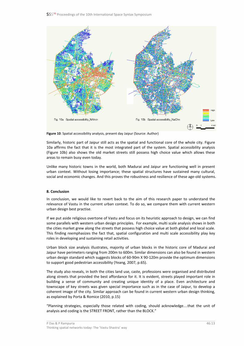
Figure 10: Spatial accessibility analysis, present day Jaipur (Source: Author)
Similarly, historic part of Jaipur still acts as the spatial and functional core of the whole city. Figure 10a affirms the fact that it is the most integrated part of the system. Spatial accessibility analysis (Figure 10b) also shows the old market streets still possess high choice value which allows these areas to remain busy even today.
Unlike many historic towns in the world, both Madurai and Jaipur are functioning well in present urban context. Without losing importance; these spatial structures have sustained many cultural, social and economic changes. And this proves the robustness and resilience of these age-old systems.
8. Conclusion
In conclusion, we would like to revert back to the aim of this research paper to understand the relevance of Vastu in the current urban context. To do so, we compare them with current western urban design best practise.
If we put aside religious overtone of Vastu and focus on its heuristic approach to design, we can find some parallels with western urban design principles. For example, multi scale analysis shows in both the cities market grew along the streets that possess high choice value at both global and local scale. This finding reemphasizes the fact that, spatial configuration and multi scale accessibility play key roles in developing and sustaining retail activities.
Urban block size analysis illustrates, majority of urban blocks in the historic core of Madurai and Jaipur have perimeters ranging from 200m to 600m. Similar dimensions can also be found in western urban design standard which suggests blocks of 60-90m X 90-120m provide the optimum dimensions to support good pedestrian accessibility (Yeang, 2007, p.65).
The study also reveals, in both the cities land use, caste, professions were organised and distributed along streets that provided the best affordance for it. It is evident, streets played important role in building a sense of community and creating unique identity of a place. Even architecture and townscape of key streets was given special importance such as in the case of Jaipur, to develop a coherent image of the city. Similar approach can be found in current western urban design thinking, as explained by Porta & Romice (2010, p.15)
“Planning strategies, especially those related with coding, should acknowledge....that the unit of analysis and coding is the STREET FRONT, rather than the BLOCK.”
P Das & P Rampuria Thinking spatial networks today: The ‘Vastu Shastra’ way
46:13
SSS10 Proceedings of the 10th International Space Syntax Symposium
The research shows both Madurai (0.159) and Jaipur (0.148) possess less intelligible spatial structure. If we compare these values with Bill’s research, (2001, p.4) which discusses intelligibility of different cities around the world, we find Madurai and Jaipur are comparable to Arabic cities (0.160) from intelligibility point of view. Further research is needed to find whether low intelligibility only relates to cities designed as per Vastu or is it a common feature of historic cities in general. It is also a question of understanding how can one embed the quality of legibility even though the spatial structure does not strongly contribute to it, like Madurai had its gopurams to give an overall sense of orientation, corresponding to the European church spires? Effectiveness of legibility as a scalar quality in design? Such questions can be food for further thought.
The above findings point towards the compatibility of Eastern belief with Western approach. We believe that these findings are valuable to the development of both Vastu Shastra and Western Urban Design principles. It reinforces that this Indian philosophy is not just mere superstition, since parallels can be drawn with the rational Western Urban Design principles. This makes it a powerful piece of evidence against the way urban development is happening today in most countries under the influence of globalisation and modernism.
Although Vastu Shastra and Western Urban Design principles seem to be fundamentally compatible, with the core values of both approaches largely overlapping; yet each have its own sanctity, establishing the fact that each and everything do not find their exact equivalent in the other. Therefore, it is probably for the best that they should be left to operate in their own spheres due to consideration of the cultural aspects. It might be more advantageous to apply Vastu in an eastern country due to the acceptance of the subject and its appreciation in the local culture. Similarly, it might be more convincing to apply rational Western Urban Design principles in a western country, without having to understand the symbolic implications of Vastu Shastra.
Coming now more specifically to the Indian context; apart from quantitatively analysing the structure of Madurai and Jaipur, this research also opened up possibilities for further researches. Not many studies have been done to determine the benchmark for walkable urban environment in India. The block size analysis of Madurai and Jaipur could be a good starting point to review and compare existing standards with historic city cores that are performing well even today. It will also be interesting to find out how other Indian cities perform in terms of intelligibility, to better understand Indian cities and its spatial structure from a legibility point of view. Multi-scale analysis of Jaipur and Madurai, shed light on the need to understand the distribution and correlation of land use with the spatial structure from both a design and planning perspective, that could significantly guide future developments.
Keeping in mind the present scenario of Indian cities characterised by unprecedented urban growth under the influence of globalisation and modernism, where there is absence of proper guidelines for design and growth of cities; this research attempts to review the applicability and relevance of Vastu principles. By using space syntax, this study is an endeavour to show its relevance in a scientific and evidence based way. The paper does not encourage application of Vastu principles without questioning them; it only tries to ensure that we do not ignore the ancient knowledge, as it has been enriched by trial and errors over ages.
P Das & P Rampuria Thinking spatial networks today: The ‘Vastu Shastra’ way
46:14

SSS10 Proceedings of the 10th International Space Syntax Symposium
References
Acharya, P. K. (1981), Indian architecture According to Manasara—Silpashastra, Manasara series, New Delhi: Oriental Books
Ananth, S. (1998), Vastu: the classical Indian science of Architecture and Design, New Delhi: Penguin books. Bafna, S. (2000), On the Idea of the Mandala as a governing device in Indian Architectural Tradition; Journal of
the Society of Architectural Historians, Vol. 59 (1), p. 26- 49 Bhargava, D. S. (2003), Environmental Considerations in Vastu Culture for Residential Building Orientation
[Online]; Available at: http://www.ieindia.org/publish/ar/0404/apr04ar1.pdf [Accessed 2nd June 2010] Bowmik, A. (1991), Puranic texts on Architecture with special reference to Matsyapurana, unpublished Ph.D
Dissertation, Jadavpur University Danielou, A. (1964), Hindu polytheism; London: Routledge& K. Paul Funo, S., Yamamoto, N., and Pant, M. (2002); Space Formation of Jaipur City, Rajastan, India An Analysis on City
Maps (1925-28) made by Survey of India. Journal of Asian Architecture and Building Engineering, p.261-269.
Gupta, S. (1995), Vastu Shilpa Shastra: the ancient Indian bio-climatically and socially responsive science of building; [Online], Available at: http://resume.smitagupta.com/publications/solar99.pdf [accessed 23rd April 2010]
Hillier, B. (2001), A Theory of the City as Object Or, how spatial laws mediate the social construction of urban space. 3rd International Space Syntax Symposium. Atlanta: Space Syntax, p.1-28
Jacobs, J. (2004), Architectural Theory of Manasara; Montreal: McGill University, unpublished PhD Dissertation Jain, N. (2001), Connection between Spirituality and Sustainable Development, M.A. Thesis, University of
Calgary, Alberta Karimi, K. (2012), A reflection on 'Order and structure in urban design'. In Journal of Space Syntax, p. 38-48 Malville, J. M. and Gujral, L. M. (2000), Ancient cities, Sacred skies Cosmic Geometries and City Planning in
Ancient India, Delhi: Indira Gandhi National Centre for Arts & Aryan books International. Mehrotra, R. J. (1990), Making Legible City Form, a case for Urban Design. Architecture and Design, p.18-25. Miester, M. (1979), Mandala and practise in Nagara architecture in North India; Journal of the American
Oriental Society, Vol. 99(2), p. 204- 219. Murugan et al. (2007), Reinforcing traditional Indian construction with modern structures [Online]; Available at:
http://nopr.niscair.res.in/bitstream/123456789/6287/1/IJTK%208(4)%20633-637.pdf [Accessed 25th May 2010]
Naik, A. (2008), Vastu Shastra: the divine school of architecture; [Online]; Available at: http://vastusindhu.com/Vastushastra%20-%20The%20Divine%20School%20ofArchitecture.pdf [Accessed 27th May 2010]
Parikh, P. (2008), Hindu Notions of Space Making, Ahemdabad: SID Research Cell. Porta, S., and Romice, O. (2010), Plot-Based Urbanism: Towards Time-Consciousness in Place-Making.
Strathclyde: UDSU – Urban Design Studies Unit, University of Strathclyde, Dept. of Architecture. Radhakrishnan S. (1951), Indian Philosophy, New Delhi: Oxford University Press. Rampuria, P. (2010), Thinking Urban Design Today - The Vastu Shashtra Way, Revisiting 6000 years of tradition,
M.A. Thesis, Oxford Brookes University. Roy, A. K. (1978), History of the Jaipur city, New Delhi, Manohar publications Sachdev, V. et al. (2002), Building Jaipur: the making of an Indian city; London : Reaktion Smith, J. (1969), Madurai, India: The Architecture of a City, M.A. Thesis, Massachusetts Institute of Technology Space Syntax (2015), Online Training Platform; Available at: http://otp.spacesyntax.net/ [Accessed 2nd Feb
2015] Sugirtharajah, S. what makes a ‘Good City’: A Hindu Perspective [Online]; Available at:
http://www.faithsforthecity.org.uk/Papers/Hinduism.pdf [Accessed 21st May 2010] Ter Mors, A (2007), Vastu Shastra: Architecture in resonance with life [Online]; Available at:
http://www.arcplusonline.com/papers/7010.pdf [Accessed 20th May 2010] Yeang, L. D. (2007), Urban Design Compendium, UK, Homes and communities agency, p.65 Vatsyayan, K. (1991), Concept of space: Ancient and Modern, New Delhi, IGNCA
P Das & P Rampuria Thinking spatial networks today: The ‘Vastu Shastra’ way
46:15