080314 final massive 3d geophysical conductive structure ... · Ø 3d model has delineated a...
TRANSCRIPT

Ausmex Mining Group Limited ACN 148 860 299E | [email protected] T | (02) 9248 0104 W | www.ausmexgroup.com.au A | Level 14, 309 Kent Street, Sydney NSW 2000
14thMarch2019
ASXMARKETRELEASE
3DGeophysicalModellingidentifiesmassive>2,000mlong,<400mwideconductivestructure(theconductor),entirelyonAusmex’stenementsinadditiontotheTier1IOCG“Canteen”targetAusmexshareswithNewcrestMiningLimited.Ø Independent Brisbane based, Geophysical Consultants, GeoDiscovery Group complete 3D
geophysicalmodellingcombininghistoricheliSAMsurvey,detailed regionalmagneticdataandVTEMsurveydata.
Ø 3Dmodelhasdelineateda>2,000mstrongconductivedrill targetup to400mwide,andranging from an approximate 200 m to >500 m depth, entirely within Ausmex’s miningtenements including the Golden Mile plunging South towards Newcrest “Canteen” andappearstoextendundertheMtFredaMiningLease.
Ø 3D model results just completed, support Independent expert Emeritus Professor KenCollersonPh.DFAusIMMpreviousfindings–“potentialforalargeIOCGorISCGmineralsourcebelowtheGoldenMile.”(ReferASXrelease25thFebruary2019)
Figure1.Representativeviewsofthe3DSAMMMCmodelandstrong>2,000mconductivefeature.
GoldenMileDrilling
For
per
sona
l use
onl
y

Figure2:Representativeplanviewofthe3DSAMMMCoutputwithintheGoldenMileSubblocks.Notetherelativeshallowdrilltargetdepthsastheconductivetargetplungesfrom~200mfromsurfaceinthenorthadjacenttheGoldenMileto>500mtothesouthundertheAusmexcontrolledMtFredaMiningLicense,withfurthergeologicalinterpretationpossiblyextendstowardsNewcrest“Canteen“drilling.
Projection:GDA(Zone54)
For
per
sona
l use
onl
y

Figure3.SchematicGeologicalinterpretationthatthelargeConductivestructureundertheGoldenMilemaybethesourceofmineralisation.
For
per
sona
l use
onl
y

Ausmex Mining Group (ASX: AMG) (“Ausmex” or “The Company”) recently engaged theGeoDiscovery Group to conduct geophysical processing and 3D modelling based on variousgeophysical data sets, including a detailed heliSAM survey, detailed regionalmagnetic data and aVTEMsurvey.
Thesubsequent3Dmodellingproducedanoutstandingresult,identifyingalargeconductivestructure>2,000minlengththatcorrelateswiththepreviousannouncedindependentexpert’sinterpretationfromProfessorKenCollersonthatalargeIOCGorISCGmineralisedsystemiscloselyassociatedwiththe Golden Mile mineralisation (Refer ASX release 19th February 2019). Professor Ken CollersondescribesthepotentialindetailviathefollowingvideolinkfromtheCompanywebsite:ProfessorKenCollersondiscussesAusmexsignificantIOCGpotential
IOCGdepositsareoftendescribedas“longribbon-likebrecciaormassiveironoxidedepositswithinfaultsorshears”.(Source:“TheGeophysicsoftheErnestHenryCu-Audeposit(N.W)QLD.M.Webb&P.Rowston;ExplorationGeophysics26(3)51-59Published1995.)
AusmexpreviouslyidentifiedalargegraphiticshearzoneassociatedwiththeLittleDukegoldminewithGoldassaysupto8.00g/tGold,1,100ppmCobaltand1.43%CopperwithinDrillholeLD18RC006,[email protected]/tGold!(ReferASXrelease29thNovember2019).TheLittleDukeGoldmineisdirectlyeastabovethelargeconductivestructure,referFigure2above.
Astagetwo3DmodellingprogramiscurrentlybeingdesignedtocontinuemodellingtheconductivestructurefurthersouthtotheEveningStarregion.ThemodellingmayrequirefurtherfieldsurveysincludingSAMandElectromagnetic(EM)andVTEMsurveys.TheEveningStarprojectisapproximately800mnorthoftheNewcrestMiningLimited“Canteen”deepIOCGdrillingcompletedinAugust2018.NewcresthavenotyetreleasedtheCanteendrillingresults.
AUSMEX2019DrillingprogramTheCompanywillcommenceamajordeep(250-650mdepth)10,000metre,RCanddiamondcoredrillingprogramtotestthe2,000mlongConductivestructuredescribedherein,commencingassoonaspracticable,withforwardplanningandrigcontractingalreadyunderwaywiththeassistanceofthirdpartyindependentgeologicalconsultantsinconsultationwiththeAusmexgeologicalteam.Drillingwillalsocontinueonthecompany’sothermajorprojectsincludingtheTrump,EveningStarandGoldenMileoveralreadyidentifiedandknownoxidemineralizationprospects.TheGoldenMileprojectisaJointVenture(AMG80%withEXCO20%)withExcoResources(QLD)PtyLtd(EXCO),a100%subsidiaryofWashingtonH.SoulPattinson,onthetwosubblocksCLON825P&CLON825UfromwithinEPM15923(ReferASXrelease16thApril2018).TheDrillingtodatecompletedbyAusmexwithintheGoldenMilecontinuestodelivershallow,highgradegoldresults,atdepthspotentiallyamenabletoabulkminingoperation.Ends.Forfurtherinformation,pleasecontact:
MattMorgan
ManagingDirector
AusmexMiningGroupLtd
For
per
sona
l use
onl
y

ForwardLookingStatements
Thematerialsmayincludeforwardlookingstatements.Forwardlookingstatementsinherentlyinvolvesubjective judgement, and analysis and are subject to significant uncertainties, risks, andcontingencies,manyofwhichareoutsidethecontrolof,andmaybeunknownto,thecompany.
Actualresultsanddevelopmentsmayvarymateriallyfromthatexpressedinthesematerials.Thetypesofuncertaintieswhicharerelevanttothecompanymayinclude,butarenot limitedto,commodityprices,politicaluncertainty,changestotheregulatoryframeworkwhichappliestothebusinessofthecompanyandgeneraleconomicconditions.Giventheseuncertainties, readersarecautionednottoplaceunduerelianceonforwardlookingstatements.
Any forward-looking statements in thesematerials speak only at the date of issue. Subject to anycontinuingobligationsunderapplicablelaworrelevantstockexchangelistingrules,thecompanydoesnot undertake any obligation to publicly update or revise any of the forward-looking statements,changesinevents,conditionsorcircumstancesonwhichanystatementisbased.
CompetentPersonStatement
Statements contained in this report relating to exploration results and potential are based oninformation compiled byMr.MatthewMorgan, who is amember of the Australasian Institute ofMiningandMetallurgy(AusIMM). Mr.Morgan is theManagingDirectorofAusmexMiningGroupLimitedandGeologistwhomhassufficientrelevantexperienceinrelationtothemineralisationstylesbeingreportedontoqualifyasaCompetentPersonasdefinedintheAustralianCodeforReportingofIdentifiedMineralresourcesandOrereserves(JORCCode2012).Mr.Morganconsentstotheuseofthisinformationinthisreportintheformandcontextinwhichitappears.
For
per
sona
l use
onl
y
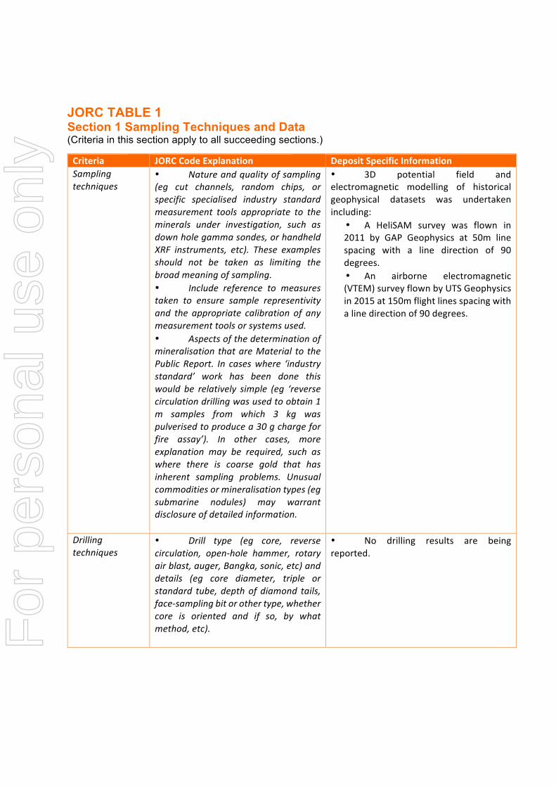
JORC TABLE 1 Section 1 Sampling Techniques and Data (Criteria in this section apply to all succeeding sections.)
Criteria JORCCodeExplanation DepositSpecificInformationSamplingtechniques
• Natureandqualityofsampling(eg cut channels, random chips, orspecific specialised industry standardmeasurement tools appropriate to theminerals under investigation, such asdownholegammasondes,orhandheldXRF instruments, etc). These examplesshould not be taken as limiting thebroadmeaningofsampling.• Include reference to measurestaken to ensure sample representivityand the appropriate calibration of anymeasurementtoolsorsystemsused.• Aspectsofthedeterminationofmineralisation thatareMaterial to thePublic Report. In caseswhere ‘industrystandard’ work has been done thiswould be relatively simple (eg ‘reversecirculationdrillingwasusedtoobtain1m samples from which 3 kg waspulverisedtoproducea30gchargeforfire assay’). In other cases, moreexplanation may be required, such aswhere there is coarse gold that hasinherent sampling problems. Unusualcommoditiesormineralisationtypes(egsubmarine nodules) may warrantdisclosureofdetailedinformation.
• 3D potential field andelectromagnetic modelling of historicalgeophysical datasets was undertakenincluding:
• A HeliSAM survey was flown in2011 by GAP Geophysics at 50m linespacing with a line direction of 90degrees.• An airborne electromagnetic(VTEM)surveyflownbyUTSGeophysicsin2015at150mflightlinesspacingwithalinedirectionof90degrees.
Drillingtechniques
• Drill type (eg core, reversecirculation, open-hole hammer, rotaryairblast,auger,Bangka,sonic,etc)anddetails (eg core diameter, triple orstandard tube,depthofdiamond tails,face-samplingbitorothertype,whethercore is oriented and if so, by whatmethod,etc).
• No drilling results are beingreported.
For
per
sona
l use
onl
y

Criteria JORCCodeExplanation DepositSpecificInformationDrillsamplerecovery
• Method of recording andassessing core and chip samplerecoveriesandresultsassessed.• Measures taken to maximisesample recovery and ensurerepresentativenatureofthesamples.• Whether a relationship existsbetween sample recovery and gradeand whether sample bias may haveoccurredduetopreferentialloss/gainoffine/coarsematerial.
• No drilling results are beingreported.
Logging • Whethercoreandchipsampleshave been geologically andgeotechnicallyloggedtoalevelofdetailto support appropriate MineralResourceestimation,miningstudiesandmetallurgicalstudies.• Whether logging is qualitativeor quantitative in nature. Core (orcostean,channel,etc)photography.• Thetotallengthandpercentageoftherelevantintersectionslogged.
• No drilling results are beingreported.
Sub-samplingtechniquesandsamplepreparation
• Ifcore,whethercutorsawnandwhetherquarter,halforallcoretaken.• If non-core, whether riffled,tube sampled, rotary split, etc andwhethersampledwetordry.• Forallsampletypes,thenature,quality and appropriateness of thesamplepreparationtechnique.• Quality control proceduresadopted for all sub-sampling stages tomaximiserepresentivityofsamples.• Measures taken toensure thatthesamplingisrepresentativeofthein-situ material collected, including forinstance results for fieldduplicate/second-halfsampling.• Whether sample sizes areappropriate to the grain size of thematerialbeingsampled.
• No drilling/sampling results arebeingreported.
For
per
sona
l use
onl
y
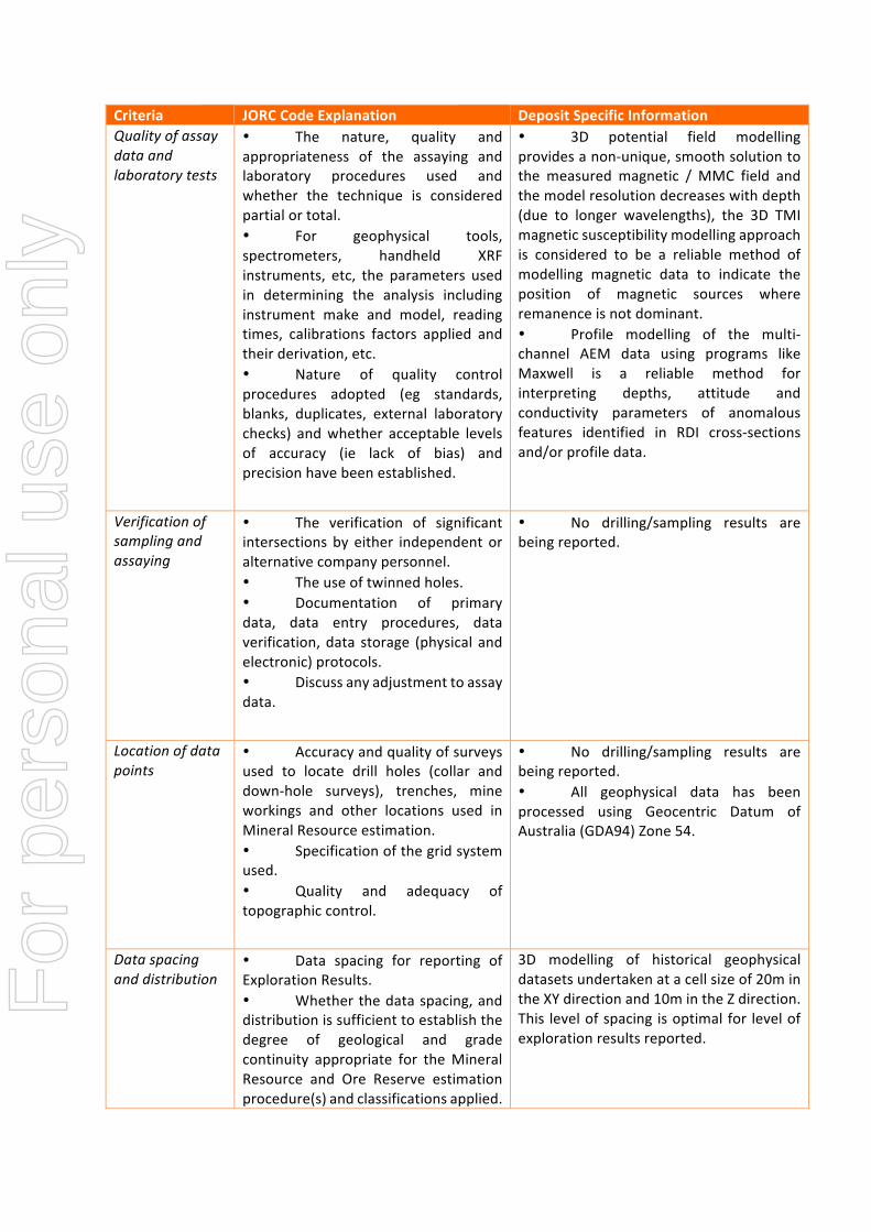
Criteria JORCCodeExplanation DepositSpecificInformationQualityofassaydataandlaboratorytests
• The nature, quality andappropriateness of the assaying andlaboratory procedures used andwhether the technique is consideredpartialortotal.• For geophysical tools,spectrometers, handheld XRFinstruments, etc, the parameters usedin determining the analysis includinginstrument make and model, readingtimes, calibrations factors applied andtheirderivation,etc.• Nature of quality controlprocedures adopted (eg standards,blanks, duplicates, external laboratorychecks) andwhether acceptable levelsof accuracy (ie lack of bias) andprecisionhavebeenestablished.
• 3D potential field modellingprovidesanon-unique,smoothsolutiontothe measured magnetic / MMC field andthemodelresolutiondecreaseswithdepth(due to longer wavelengths), the 3D TMImagneticsusceptibilitymodellingapproachis considered to be a reliable method ofmodelling magnetic data to indicate theposition of magnetic sources whereremanenceisnotdominant.• Profile modelling of the multi-channel AEM data using programs likeMaxwell is a reliable method forinterpreting depths, attitude andconductivity parameters of anomalousfeatures identified in RDI cross-sectionsand/orprofiledata.
Verificationofsamplingandassaying
• The verification of significantintersectionsby either independentoralternativecompanypersonnel.• Theuseoftwinnedholes.• Documentation of primarydata, data entry procedures, dataverification,data storage (physical andelectronic)protocols.• Discussanyadjustmenttoassaydata.
• No drilling/sampling results arebeingreported.
Locationofdatapoints
• Accuracyandqualityofsurveysused to locate drill holes (collar anddown-hole surveys), trenches, mineworkings and other locations used inMineralResourceestimation.• Specificationofthegridsystemused.• Quality and adequacy oftopographiccontrol.
• No drilling/sampling results arebeingreported.• All geophysical data has beenprocessed using Geocentric Datum ofAustralia(GDA94)Zone54.
Dataspacinganddistribution
• Data spacing for reporting ofExplorationResults.• Whetherthedataspacing,anddistributionissufficienttoestablishthedegree of geological and gradecontinuity appropriate for theMineralResource and Ore Reserve estimationprocedure(s)andclassificationsapplied.
3D modelling of historical geophysicaldatasetsundertakenatacellsizeof20mintheXYdirectionand10mintheZdirection.This levelofspacing isoptimalfor levelofexplorationresultsreported.
For
per
sona
l use
onl
y
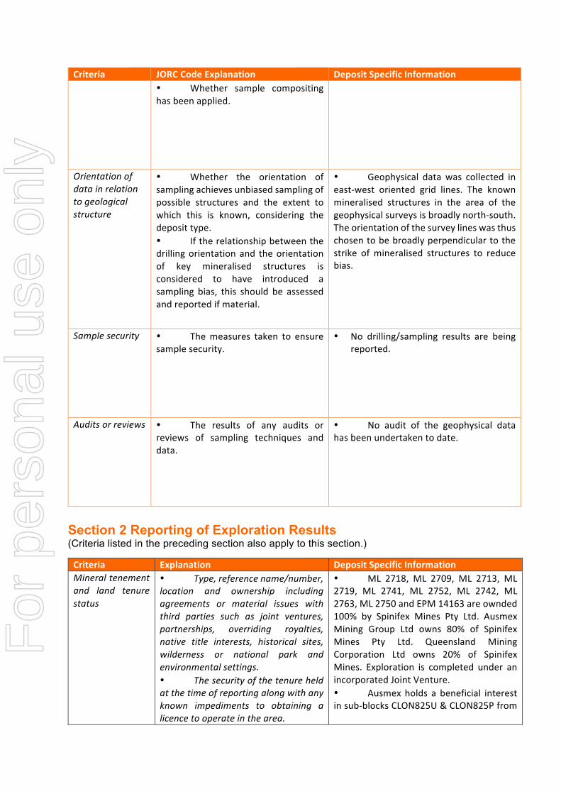
Criteria JORCCodeExplanation DepositSpecificInformation• Whether sample compositinghasbeenapplied.
Orientationofdatainrelationtogeologicalstructure
• Whether the orientation ofsamplingachievesunbiasedsamplingofpossible structures and the extent towhich this is known, considering thedeposittype.• Iftherelationshipbetweenthedrillingorientationand theorientationof key mineralised structures isconsidered to have introduced asampling bias, this should be assessedandreportedifmaterial.
• Geophysical data was collected ineast-west oriented grid lines. The knownmineralised structures in the area of thegeophysicalsurveysisbroadlynorth-south.Theorientationofthesurveylineswasthuschosentobebroadlyperpendiculartothestrike ofmineralised structures to reducebias.
Samplesecurity • Themeasures taken to ensuresamplesecurity.
• No drilling/sampling results are beingreported.
Auditsorreviews • The results of any audits orreviews of sampling techniques anddata.
• No audit of the geophysical datahasbeenundertakentodate.
Section 2 Reporting of Exploration Results (Criteria listed in the preceding section also apply to this section.)
Criteria Explanation DepositSpecificInformationMineraltenementand land tenurestatus
• Type,referencename/number,location and ownership includingagreements or material issues withthird parties such as joint ventures,partnerships, overriding royalties,native title interests, historical sites,wilderness or national park andenvironmentalsettings.• Thesecurityofthetenureheldatthetimeofreportingalongwithanyknown impediments to obtaining alicencetooperateinthearea.
• ML 2718, ML 2709, ML 2713, ML2719, ML 2741, ML 2752, ML 2742, ML2763,ML2750andEPM14163areownded100% by Spinifex Mines Pty Ltd. AusmexMining Group Ltd owns 80% of SpinifexMines Pty Ltd. Queensland MiningCorporation Ltd owns 20% of SpinifexMines. Exploration is completed under anincorporatedJointVenture.• Ausmex holds a beneficial interestinsub-blocksCLON825U&CLON825Pfrom
For
per
sona
l use
onl
y

Criteria Explanation DepositSpecificInformation EPM 15923 under an 80/20 Joint Venture
withCopperChem.• EPM 14475, EPM15858 & EPM18286 are held by Queensland MiningCorporationPtyLtd(QMC).AusmexMiningGroupown80%ofQMC.QMCown20%ofSpinifex Mines Pty Ltd. Exploration iscompleted under an incorporated JointVenture.• ML2549,ML2541andML2517areowned100%byAusmexMiningGroup.• Alltenementsareingoodstanding.
Exploration donebyotherparties
• Acknowledgment andappraisal of exploration by otherparties.
• Thefollowingairbornegeophysicaldatasets were acquired as part of pastcompany exploration (by Exco Resources)andhavebeenusedtoassistinterpretationanddelineateregionsofinterest.• AHeliSAMsurveywasflownin2011by GAP Geophysics and the standardproduct suite includes the Magnetic TMI,the SAM MMC (magneto-metricconductivity) and SAM TFEM (total-fieldEM)channels.• An airborne electromagnetic(VTEM)surveyflownbyUTSGeophysics in2015at150mflightlinesspacing.Aspartofthe standard product suite, a database oftheResistivityDepthImaging(RDI)derivedoverthestudyregionwassuppliedbyUTSGeophysics.• AuxiliaryairbornegeophysicaldatawastakenfromQDME(Cloncurry)openfilesurvey magnetics flown in 2017 (at linespacingof100m).
Geology • Deposit type, geological
settingandstyleofmineralisation.
• Various prospects within theprojectareaoccur,predominantlyasshearhostedandhydrothermalveindeposits(Au-Cu-Co), and intrusion-related Au-Cu-Codeposits.
Drill holeInformation
• A summary of all informationmaterial to the understanding of theexploration results including atabulationofthefollowinginformationforallMaterialdrillholes:eastingandnorthingofthedrillholecollar
• No drilling/sampling results arebeingreported.F
or p
erso
nal u
se o
nly

Criteria Explanation DepositSpecificInformation• elevationorRL(ReducedLevel–elevationabovesealevelinmetres)ofthedrillholecollar• dipandazimuthofthehole• down hole length andinterceptiondepth• holelength.• If the exclusion of thisinformationisjustifiedonthebasisthattheinformationisnotMaterialandthisexclusion does not detract from theunderstanding of the report, theCompetent Person should clearlyexplainwhythisisthecase.
Data aggregationmethods
• In reporting ExplorationResults, weighting averagingtechniques, maximum and/orminimumgradetruncations(egcuttingofhighgrades)andcut-offgradesareusuallyMaterialandshouldbestated.• Where aggregate interceptsincorporateshortlengthsofhigh-graderesultsandlongerlengthsoflow-graderesults, the procedure used for suchaggregationshouldbestatedandsometypicalexamplesofsuchaggregationsshouldbeshownindetail.• The assumptions used for anyreporting of metal equivalent valuesshouldbeclearlystated.
• Nodrilling/samplingresultsarebeingreported.
Relationshipbetweenmineralisationwidths andinterceptlengths
• These relationships areparticularly important inthereportingofExplorationResults.• If the geometry of themineralisationwithrespecttothedrillholeangle isknown, itsnatureshouldbereported.• If it isnotknownandonlythedownhole lengthsarereported,thereshould be a clear statement to thiseffect(eg‘downholelength,truewidthnotknown’).
• No drilling/sampling results arebeingreported.
Diagrams • Appropriatemapsandsections(with scales) and tabulations ofintercepts should be included for anysignificant discovery being reportedTheseshouldinclude,butnotbelimited
• Appropriatemapsanddiagramsareprovidedinthebodyofthisreport.
For
per
sona
l use
onl
y
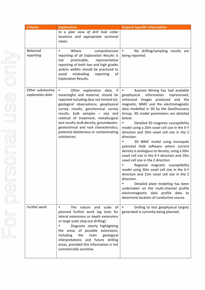
Criteria Explanation DepositSpecificInformationto a plan view of drill hole collarlocations and appropriate sectionalviews.
Balancedreporting
• Where comprehensivereporting of all Exploration Results isnot practicable, representativereportingofbothlowandhighgradesand/or widths should be practiced toavoid misleading reporting ofExplorationResults.
• No drilling/sampling results arebeingreported.
Other substantiveexplorationdata
• Other exploration data, ifmeaningful and material, should bereportedincluding(butnotlimitedto):geological observations; geophysicalsurvey results; geochemical surveyresults; bulk samples – size andmethod of treatment; metallurgicaltestresults;bulkdensity,groundwater,geotechnical and rock characteristics;potentialdeleteriousorcontaminatingsubstances.
• Ausmex Mining has had availablegeophysical information reprocessed,enhanced images produced and themagnetic, MMC and the electromagneticdatamodelled in 3D by the GeoDiscoveryGroup. 3Dmodel parameters are detailedbelow:• Detailed3Dmagneticsusceptibilitymodelusinga20mvoxelcellsizeintheX-Ydirection and 10m voxel cell size in the Zdirection.• 3D MMC model using monopolepotential field software where currentdensityisanalogoustodensity,usinga20mvoxelcellsizeintheX-Ydirectionand10mvoxelcellsizeintheZdirection.• Regional magnetic susceptibilitymodelusing30mvoxel cell size in theX-Ydirection and 15m voxel cell size in the Zdirection.• Detailed plate modeling has beenundertaken on the multi-channel profileelectromagnetic data profile data todeterminelocationofconductivesource.
Furtherwork • The nature and scale ofplanned further work (eg tests forlateralextensionsordepthextensionsorlarge-scalestep-outdrilling).• Diagrams clearly highlightingthe areas of possible extensions,including the main geologicalinterpretations and future drillingareas,providedthisinformationisnotcommerciallysensitive.
• Drilling to test geophysical targetsgeneratediscurrentlybeingplanned.
For
per
sona
l use
onl
y