1 2principal specialist, hrd; 3senior specialist, irm...
TRANSCRIPT

Dr. A.F.M Afzal Hossain1, PEng.
Saad Siddiqui2 PEng.
Md. Jakir Hossain3
Zannatul Ferdous Haque4
1Deputy Executive Director (P&D); 2Principal Specialist, HRD; 3Senior Specialist, IRM, 4Junior Engineer, R&D
Dr. A.F.M Afzal Hossain1, PEng.
Saad Siddiqui2 PEng.
Md. Jakir Hossain3
Zannatul Ferdous Haque4

Introduction Groundwater has been the main source of irrigation and other
uses using a large number of deep (DTW) and shallow
tubewell (STW) both by public and private initiatives
In recent years, decline of groundwater table is observed in
some areas due to over-abstraction of groundwater
Lowering of groundwater table during dry months creates a
problem for operation of STW and hand tubewell (HTW)
Many ponds and tanks become derelict due to lowering of
groundwater table creating shortage of water for both
domestic use and use by the livestock population
Arsenic contamination is also observed in some places of
shallow groundwater along major river banks.

Policy Issues
There are various water policies such as
National Water Policy (NWPo)
Integrated Water Resources Management (IWRM)
National Environmental Management Action Plan
(NEMAP)

Integrated Water Resources Management (IWRM) is aprocess which promotes the coordinated development andmanagement of water, land and related resources in orderto maximize economic and social welfare in an equitablemanner, holistically without compromising thesustainability of vital ecosystems and the environment
Groundwater is a component of IWRM strategies althoughoften neglected. The three E’s of IWRM (Economicefficiency, Environmental sustainability and social Equity)are the drivers of water sector reform, includinggroundwater
Integrated Water Resources Management (IWRM)

Sectoral Use of Groundwater (GW)
Source: http://www.fao.org/nr/water/aquastat/data/query/results.html

Environment9%
Agriculture
32%
Water Supply 3%
Instream56%
Source: WARPO
Proportion of Water Demand (2025)

Trend of Irrigation Water use in Bangladesh
0
1000
2000
3000
4000
5000
6000
19
79-
80
19
80-
81
19
81-
82
19
82-
83
19
83-
84
19
84-
85
19
85-
86
19
86-
87
19
87-
88
19
88-
89
19
89-
90
19
90-
91
19
91-
92
19
92-
93
19
93-
94
19
94-
95
19
95-
96
19
96-
97
19
97-
98
19
98-
99
19
99-
00
20
00-
01
20
01-
02
20
02-
03
20
03-
04
20
04-
05
20
05-
06
20
06-
07
20
07-
08
20
08-
09
20
09-
10
20
10-
11
Irri
ga
tio
n C
ove
rage
('0
00
Ha
)
Year
Trend of Irrigation Development in Bangladesh
SW Irri, GW Irri. Total Irri
Source: BBS, BADC, DAE & BMDA

Geomorphic divisions of Bangladesh
Alam et al, 1990

Groundwater Resources Monitoring
Groundwater monitoring comprises the collection,
analysis and storage of data on a regular basis to
provide information for effective groundwater
management to a variety of stakeholders.

Why Monitor?
Assess and control the impacts and risks of human activities on groundwater quantity and quality
Detect changes in groundwater storage, flow and quality during well field operation.
Bridge knowledge gaps in the general understanding of the resource and its changes in time .
Groundwater is also an indicator of climate change. Monitoring of groundwater levels and recharge rates will help build greater understanding of the resource and the possible impacts of climate change upon it.

Effective Groundwater Monitoring Effective groundwater monitoring should be driven by
a specific objective and the data collected should be systematically stored for future use
The effectiveness of groundwater monitoring may be improved by careful attention to
a) data collection network design b) system implementation and maintenance c) data management, interpretation and use d) accessible monitoring stationse) use indicator determinants to reduce analytical costf) participatory monitoring amongst water users

Groundwater Level Monitoring BWDB has a network of GWL monitoring using 117
Observation wells
IWM conducted a study in 2000 that was funded by JICA
This study was to monitor the groundwater level scenario in
central Dhaka as well as groundwater level at the peripheral
rivers surrounding Dhaka city
It was observed that the
groundwater depletion in central
Dhaka is about 3m whereas at the
peripheral rivers, the groundwater
level depletes 1.5-2m in dry period

Total Groundwater Abstraction (699 Mm3) of
Dhaka City
74%
18%
4% 4%
Domestic supply
Commercial supply
Industrial supply
Community supply
Abstraction balance by subsurface inflow,
vertical recharge and mining
86.29%
13.71%Subsurface inflow and
vertical recharge
Mining
Groundwater Abstraction in Dhaka city (2004-05)

Without conjunctive use1997 - Max depth, 25m
GW - 98%

Without conjunctive use2016 - Max depth, 45m
Population - 9.74 mill Abstraction - 507 Mm3
DTW - 387 Nos
Without conjunctive use2006 - Max depth, 35m
Population - 7.74 mill Abstraction - 408 Mm3
DTW - 312 Nos

With conjunctive use1997 - Max depth, 15m
SW - May-OctGW - Nov-Apr

-1500
-1000
-500
0
500
1000
1500
mm
1997
20062016
-3000
-2000
-1000
0
1000
2000
3000
4000
mm
19972006
2016
-1500
-1000
-500
0
500
1000
1500
2000
2500
mm
20162006
1997
-3000
-2000
-1000
0
1000
2000
3000
4000
mm 1997
20062016
-800
-600
-400
-200
0
200
400
600
800
mm
19972006
2016
-2500-2000-1500-1000-500
0500
10001500200025003000
mm
1997
20062016
-1500
-1000
-500
0
500
1000
1500
2000
2500
1 2 3
Abstraction
Recharge
Surplus
Deficit
Groundwater Balance of Dhaka City

Trend of Groundwater Development in Northwest Region
•Groundwater use for agricultural
production has significantly been
increased over the time in North-
west region
• The other areas where
groundwater is widely used are
the domestic and drinking
purposes
•Contribution of groundwater for
domestic water supply in rural
and urban towns in northwest
region is about 97%
•The wide spread use of
groundwater for drinking purpose
has resulted in significant
reduction in water borne diseases
like cholera, diarrhea, dysentery,
typhoid etc

•In some places of the north-west region, depth to groundwater table goes below 7.0
to 20.0 m
•During the peak time of recharge, groundwater table almost regains to its original
positions except some places of the area such as Tanore Thana
•In these areas, recharge is less compared to the total abstractions
•Decline of groundwater table is mainly occurred due to higher abstraction round the
year

Groundwater Level Monitoring in Coastal Region
-1.3
-1.1
-0.9
-0.7
-0.5
-0.3
-0.1
16-Mar-13 23-Mar-13 30-Mar-13 6-Apr-13 13-Apr-13 20-Apr-13 27-Apr-13
WL (
mP
WD
)
Date
Water LevelObservation Well no: 15, Well ID: KO_L_2_3

Groundwater Quality Monitoring
BWDB has a network of GWQ monitoring using 117 Observation wells
Similarly DPHE, BMDA and BADC have their own monitoring system
IWM installs and collects data from observation well using field kit and lab tests measuring the values of different parameter
The values of each parameter compared with standard for agriculture and drinking to see whether the qualities are within safe limits

In the north-west (NW) region a study was conducted by IWM
There is no Boron and Fluoride toxicity in the NW region
Manganese concentration is high in some places which might
create potability and palatability problems
Nitrate contamination in groundwater is noticed in areas where
open latrine is located in the vicinity of drinking water sources
such as a hand tube well
The study area possess no salinity problem except in a pocket
area of Manda Upazila under Naogaon district
In the early 90’s Arsenic contamination was observed in few
HTWs of Chapai-Nawabgonj district in the southwestern part
of the Barind area. However, in other part of the area, the
arsenic content of groundwater from DTWs is <0.01 mg/L

Groundwater Quality Monitoring in Coastal Region
500
1000
1500
2000
2500
21-Mar-13 28-Mar-13 4-Apr-13 11-Apr-13 18-Apr-13 25-Apr-13
EC
(µ
s/C
m)
Date
Electric Conductivity (EC)Observation Well no: 14, Well ID: KO_L_2_2
4000
4250
4500
4750
5000
5250
5500
5750
6000
1-Jan-13 16-Jan-13 1-Feb-13 16-Feb-13 4-Mar-13 19-Mar-13 4-Apr-13 19-Apr-13 5-May-13
EC
(µ
s/C
m)
Date
Electric Conductivity (EC)Observation Well no: 40, Well ID: KA_R_2_1
Under Joint Action Research project IWM collects data from observation wells

Constraints to GW use

Hard to Reach Areas for Water Supply in Bangladesh
Source: WSP, 2012
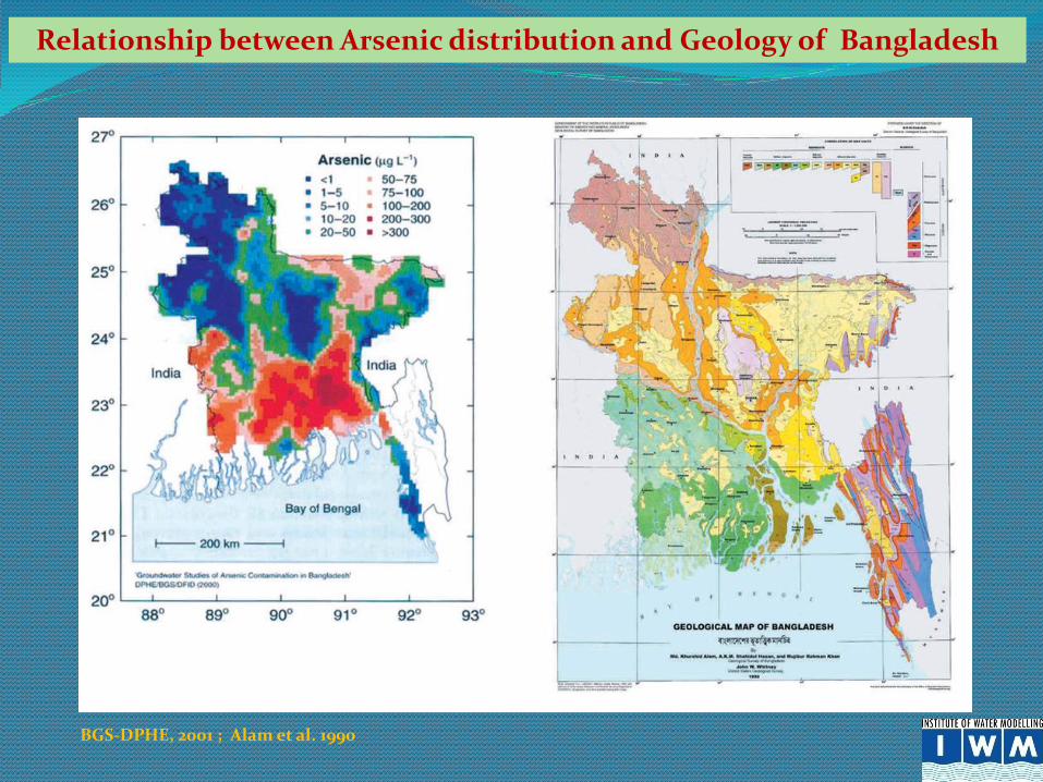
Relationship between Arsenic distribution and Geology of Bangladesh
BGS-DPHE, 2001 ; Alam et al. 1990

Distribution of Arsenic in Bangladesh
Source: DPHE/BGS/DFID, 2000

Groundwater Quality
Source: NWRD, WARPO, 2003

Why Use Groundwater Model
Groundwater models are mainly used for resource assesment
Groundwater models are also used to represent the naturalgroundwater flow in the environment
Groundwater models try to predict the fate and movement ofthe chemical
The models may be used to predict the effects of hydrologicalchanges (like groundwater abstraction or irrigationdevelopments) on the behavior of the aquifer
Groundwater models are used in various water managementplans for urban areas

Being able to model groundwater systems can be
tremendously useful for a wide range of applications
Using a model helps people visualize a system which they
cannot see, and it can illustrate key points of interest or be
used to gather information about a system
People who have difficulty understanding water use
policy and other issues sometimes benefit from instruction
with a groundwater model in which issues are visually
illustrated

Groundwater Modelling Tools:
IWM uses three complete packages of mathematical modelling. These are:
MIKE SHE
MODFLOW
FEFLOW

MIKE SHE is a fully distributed, physically-based
hydrologic model that can simulate water movement over
and under the earth's surface
MIKE SHE can be used for the analysis, planning and
management of a wide range of water resources and
environmental problems related to surface water and
groundwater
Five basic modules of MIKE SHE water movement are:
Overland Flow, Channel/River Flow, Evapotranspiration,
Unsaturated Flow and Saturated/Groundwater Flow

Evapotranspiration
Overland Flow
River Flow
Flow in Unsaturated Zone
Groundwater Flow
Approach

•US Geological Survey (USGS) originated Visual MODFLOW is
an easy-to-use modeling environment for practical applications in
three-dimensional groundwater flow and contaminant transport
simulations
• It is a finite difference model, which solves a system of
equations describing the major flow and related processes in the
hydrological system
• Visual MODFLOW simulates three-dimensional ground-water
flow through a porous medium by using a finite-difference
method

FEFLOW
FEFLOW is the first complete groundwater modeling
software package to successfully combine powerful graphical
features with sophisticated analysis tools and robust numerical
algorithms for:
Density-dependent flow (salt water intrusion)
Transient or steady-state flow
Saturated and unsaturated flow
Multiple free surfaces (perched water table)
Mass and heat transport
FEFLOW has been specifically designed to meet the advanced
technology requirements of expert modeling professionals
involved in complex groundwater modeling projects

B a y o f B e n g a l
Fourth Dhaka Water
Supply Project
Meghna Dhonagoda
Irrigation Project
North Bangla Deep
Tube Well Project
Modelling Technique used in Selected GW Projects
Conjunctive use Model
for SW/GW interaction in
CAD Project for Teesta Barrage
Pilot Conjunctive use Model
for SW/GW interaction in
lower Atrai
Deep Tube Well Installation
Project in Barind Area
BMDA Unit 2
BMDA Phase-III

Coverage of Coarse Groundwater Models at IWM

Case Study on GW Model in Barind Area (Phase-1)
Project Map of 25 Thana in Rajshahi, Nawabganj & Naogaon Districts
Project Covers 25 thana
of Rajshahi, Nawabganj
& Naogaon Districts
Total Area = 750,000 ha
Cultivable Area = 595,760 ha
Population = About 2 million
Rainfall ~ 1200 to 1700 mm
Nos of DTW = 6047
Nos of STW ~ 70,000

Data Collection & Processing
Topography, Cross Section Survey & Geo-referencing
Hydro-meteorological & Hydrological Data
Hydro-geological Investigation
Soil Sample Testing & Analysis
Percolation and Seepage in the Paddy Field
Hydro-Geochemical Investigation
Land Use and Vegetation
Water Abstraction and Irrigation by Different Modes

Objectives of the study
•Assessment of Thana wise available safe groundwater
resources and recharge potential using groundwater model
•Development of guidelines for effective Groundwater
Monitoring System
•Development of Management Information System to store,
review and analyze time series and spatial data
•Irrigation adoption based on model results for an efficient
planning and management of the groundwater resources

Model Calibration
.
Groundwater Level
Calibration Period: 1997-2003
INDIA
BMDA GW Well
BWDB GW Well
IWM GW Well

Model Calibration
Groundwater Level
Calibration Period: 1997-2003
INDIA
BMDA GW Well
BWDB GW Well
IWM GW Well
ObservedSimulated

Model Validation
Groundwater Level
Validation Period: 2004-2005
INDIA
BMDA GW Well
BWDB GW Well
IWM GW Well
Simulated Observed

FindingsThana Area (km2)
Available
Resource (mm)
Useable
Resource (mm)
Irr Requirement
Year: 2005 (mm)
Remaining
Water (mm)
Atrai 284 931 838 399 439
Badalgachi 214 607 546 437 109
Bagha 184 369 332 207 125
Bagmara 363 725 653 422 231
Bholahat 124 696 626 377 249
Charghat 165 343 309 368 -59
Dhamoirhat 301 296 266 462 -196
Durgapur 195 734 661 414 247
Godagari 472 231 208 295 -87
Gomastapur 318 189 170 180 -10
Mohadebpur 398 305 275 482 -208
Manda 376 553 498 251 247
Mohonpur 163 619 557 345 212
Nachole 284 405 365 206 159
Naogaon 276 564 508 455 53
Nawabganj 452 913 822 134 688
Niamatpur 449 236 212 290 -78
Paba 280 542 488 287 201
Patnitala 382 331 298 286 12
Porsha 253 335 302 105 197
Puthia 193 461 415 380 35
Raninagar 258 740 666 521 145
Sapahar 245 510 459 193 266
Shibganj 525 586 527 280 247
Tanore 295 180 162 280 -118

Conclusions of Case Study
It is beneficial to augment surface water irrigation. Groundwater condition is
greatly improved by augmented recharge from surface water irrigation
During peak time, groundwater table almost regains to its original positions
except some areas such as Tanore Upazilas. This is mainly due to higher
abstraction in monsoon period. At the same time, recharge is also less compare
to the total abstractions in these areas
Present withdrawals of groundwater to fulfill the requirement of Boro in excess
of potential recharges and available resources have created the tendency of
continuous lowering of groundwater level in some Upazilas. Monitoring of
groundwater level in these Upazilas need to be carefully continued for future
action

•Major knowledge gaps have been observed on uncertainty in the water
availability under climate change consideration, uncertainty in the upstream
withdrawal, occurrence of Arsenic, water utility, natural and environmental
water requirements
•Many research has already been conducted on Arsenic occurrence and
possible solutions, there are still considerable gaps in the understanding of
release mechanism
•Key areas for high priority research are implications for food safety of
irrigation with Arsenic contaminated water; the horizontal and vertical extent
of contamination;
•Another major issue is prediction of whether aquifer contamination will
change with time, cost-effective solutions for immediate mitigation and long-
term solutions

•The utility of groundwater depends on its quality, the level
from which it must be pumped and its sustainable yield
•Remarkable growth in groundwater use over the last two
decades, both for domestic and irrigation use, implies that
important planning considerations may be explored further
•Relationship between water and the natural environment is not
well understood
•The knowledge gaps exist in both national and basin level
• Filling gaps is seen as an essential and integral component to
meet the basin level water scarcity in future

•Groundwater
quality
particularly
salinity is a major
issue in the
coastal region as
well as in the pilot
areas
• An assessment
of the present
state of ground
water salinity has
been performed
using available
secondary source
data GW Salinity, Dry & Wet Period 2011-2012
Depth upto 150, Pilot Area-1

GW Salinity, Dry & Wet Period 2011-2012
Depth upto 150, Pilot Area-2

Database Development
Location of Nest Wells

Concluding Remarks
As groundwater resource is limited both qualitative and
quantitative monitoring of groundwater is required
Qualitative monitoring is required to assess whether the
groundwater recharge is adequate or not
If recharge is less than withdrawal then there will be
chance of groundwater mining which is alarming
Qualitative monitoring is required to assess whether all
the parameters are within the range or not

It is recognized that water resources problems cannot be
treated in isolation
The problems are seldom isolated and their solution
requires a holistic approach to water management that
must address different, often conflicting, demands for
water
Problems like wetland protection or the conjunctive use of
surface water and groundwater resources require the
integrated management of surface water and groundwater
together with the water chemistry and ecology

Regional model for Surface water is available. But there is no regional model for groundwater
Groundwater model for whole Bangladesh is required for coupling surface water and groundwater model
This will help predicting future scenario of groundwater resources