1. a) normal fault - a geologic fault in which the hanging wall has moved downward relative to the...
TRANSCRIPT
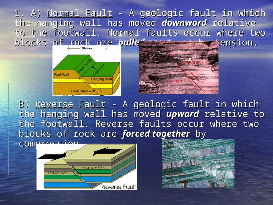
1. A) 1. A) Normal FaultNormal Fault - A geologic fault in which the - A geologic fault in which the hanging wall has moved hanging wall has moved downwarddownward relative to the relative to the footwall. Normal faults occur where two blocks of rock footwall. Normal faults occur where two blocks of rock are are pulled apartpulled apart, as by tension., as by tension.
B) B) Reverse FaultReverse Fault - A geologic fault in which the - A geologic fault in which the hanging wall has moved hanging wall has moved upwardupward relative to the relative to the footwall. Reverse faults occur where two blocks of rock footwall. Reverse faults occur where two blocks of rock are are forced togetherforced together by compression. by compression.

C) Transform Fault - A geologic fault in - A geologic fault in which the crust slides horizontally which the crust slides horizontally apart.apart.

2. Transform Fault2. Transform Fault
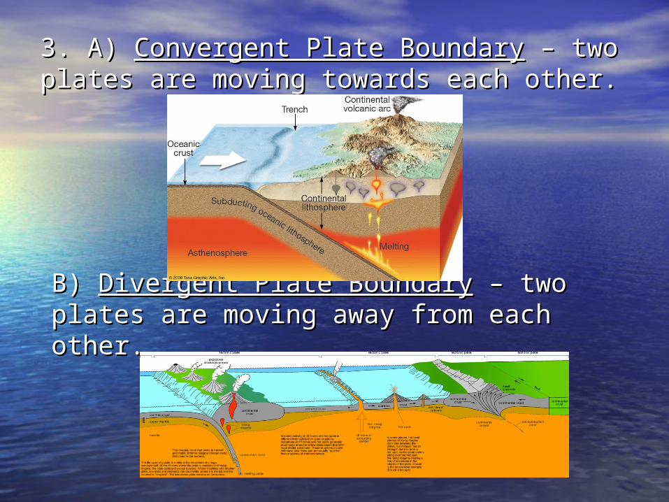
3. A) 3. A) Convergent Plate BoundaryConvergent Plate Boundary – two – two plates are moving towards each other.plates are moving towards each other.
B) B) Divergent Plate BoundaryDivergent Plate Boundary – two plates are – two plates are moving away from each other.moving away from each other.
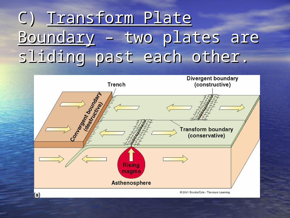
C) C) Transform Plate BoundaryTransform Plate Boundary – – two plates are sliding past two plates are sliding past each other.each other.

4. Volcanic eruptions, mountain 4. Volcanic eruptions, mountain building, and earthquakes.building, and earthquakes.
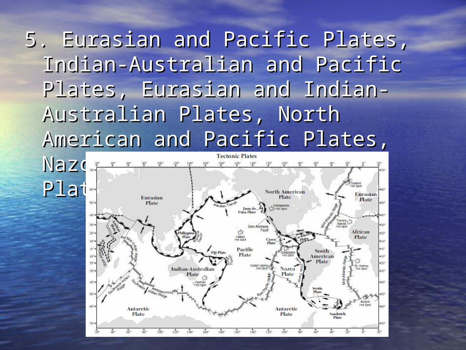
5. Eurasian and Pacific Plates, Indian-5. Eurasian and Pacific Plates, Indian-Australian and Pacific Plates, Australian and Pacific Plates, Eurasian and Indian-Australian Eurasian and Indian-Australian Plates, North American and Pacific Plates, North American and Pacific Plates, Nazca and South American Plates, Nazca and South American Plates.Plates.
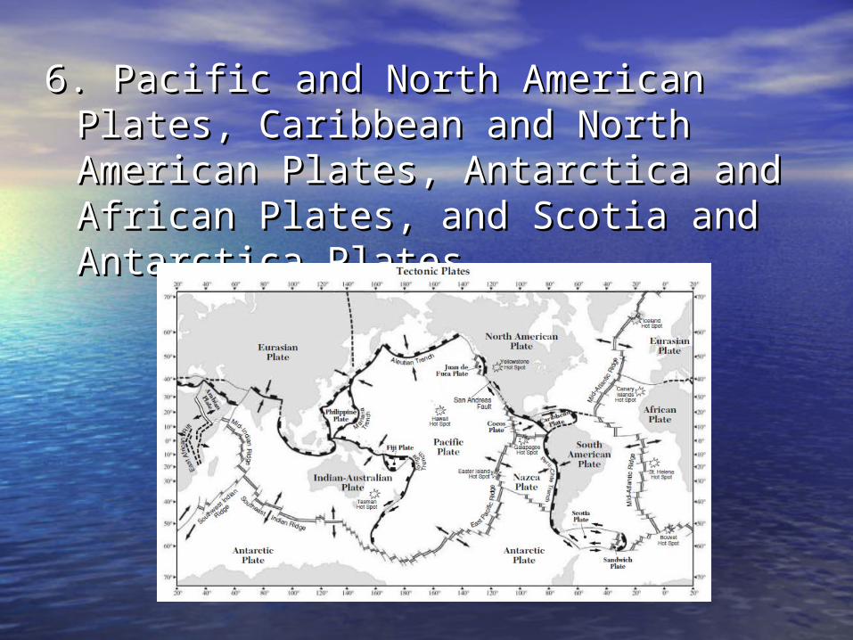
6. Pacific and North American Plates, 6. Pacific and North American Plates, Caribbean and North American Caribbean and North American Plates, Antarctica and African Plates, Plates, Antarctica and African Plates, and Scotia and Antarctica Plates.and Scotia and Antarctica Plates.
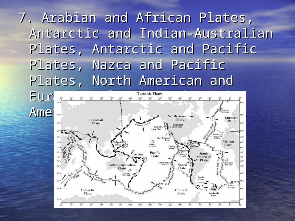
7. Arabian and African Plates, Antarctic 7. Arabian and African Plates, Antarctic and Indian-Australian Plates, and Indian-Australian Plates, Antarctic and Pacific Plates, Nazca Antarctic and Pacific Plates, Nazca and Pacific Plates, North American and Pacific Plates, North American and Eurasian Plates, and South and Eurasian Plates, and South American and African Plates. American and African Plates.
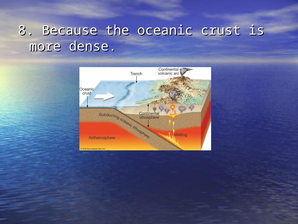
8. Because the oceanic crust is more 8. Because the oceanic crust is more dense.dense.
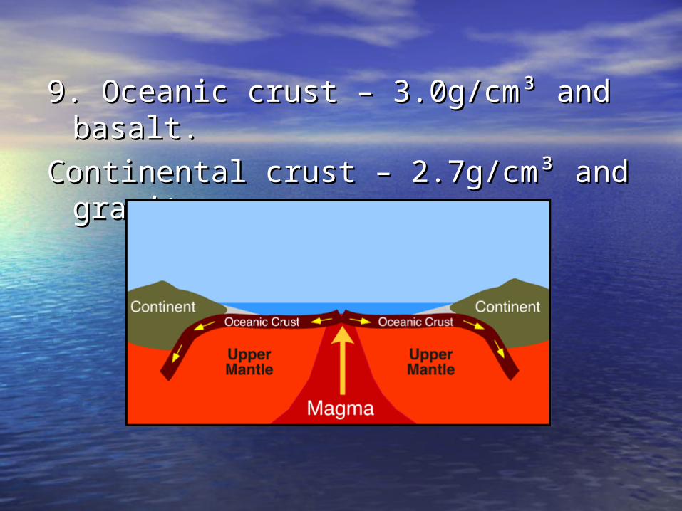
9. Oceanic crust – 3.0g/cm9. Oceanic crust – 3.0g/cm³ and basalt.³ and basalt.
Continental crust – 2.7g/cmContinental crust – 2.7g/cm³ and ³ and granite.granite.
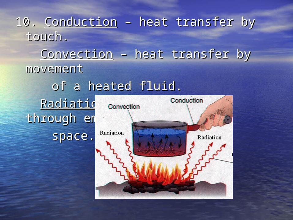
10. 10. ConductionConduction – heat transfer by touch. – heat transfer by touch.
ConvectionConvection – heat transfer by – heat transfer by movement movement
of a heated fluid.of a heated fluid.
RadiationRadiation – heat transfer through – heat transfer through empty empty
space.space.

11. Convection Currents11. Convection Currents
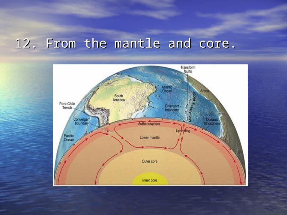
12. From the mantle and core.12. From the mantle and core.

13. Differences in temperature and 13. Differences in temperature and density, and gravity. density, and gravity.

14. 14. AsthenosphereAsthenosphere – plastic-like layer – plastic-like layer in the upper mantle that flows and in the upper mantle that flows and causes plate movement.causes plate movement.

15. 15. LithosphereLithosphere – includes the crust – includes the crust and upper rigid mantle.and upper rigid mantle.

16. Sea-Floor Spreading; found on 16. Sea-Floor Spreading; found on either side of mid-ocean ridges.either side of mid-ocean ridges.
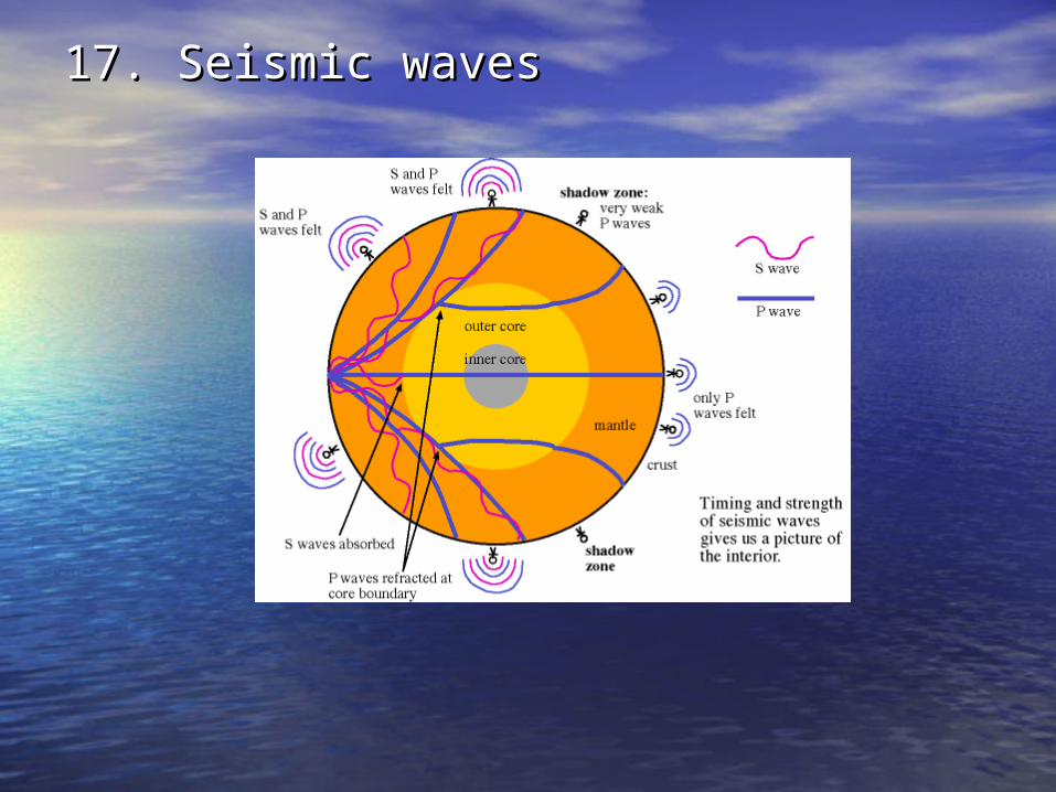
17. Seismic waves17. Seismic waves

18. Movement along fault lines, 18. Movement along fault lines, volcanic eruptions, landslides, or volcanic eruptions, landslides, or movement of large vehicles.movement of large vehicles.
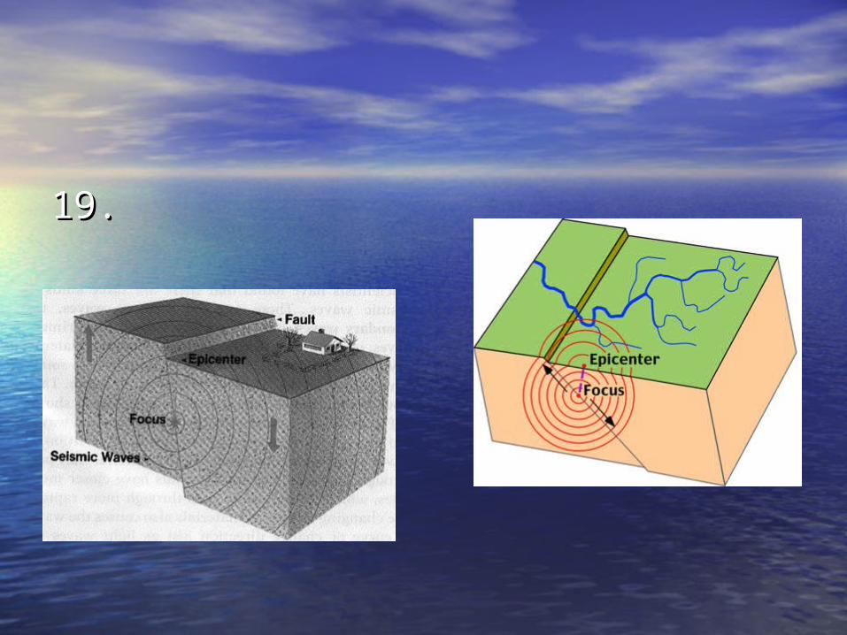
19. 19.
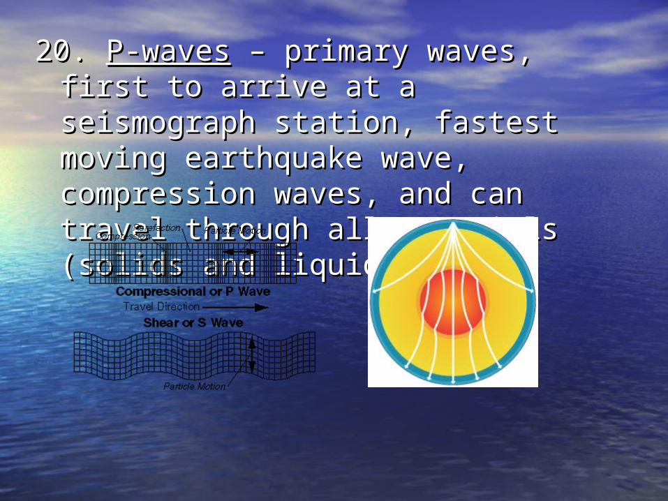
20. 20. P-wavesP-waves – primary waves, first to – primary waves, first to arrive at a seismograph station, arrive at a seismograph station, fastest moving earthquake wave, fastest moving earthquake wave, compression waves, and can travel compression waves, and can travel through all materials (solids and through all materials (solids and liquids).liquids).

21. S21. S-waves-waves – secondary waves, – secondary waves, second to arrive at a seismograph second to arrive at a seismograph station, slower moving earthquake station, slower moving earthquake wave, shear or transverse waves, wave, shear or transverse waves, and can travel ONLY through solids.and can travel ONLY through solids.

22. 12 minutes 40 seconds22. 12 minutes 40 seconds

23. 2 minutes and 10 seconds23. 2 minutes and 10 seconds

24. P-waves are deflected and S-waves 24. P-waves are deflected and S-waves are absorbed.are absorbed.
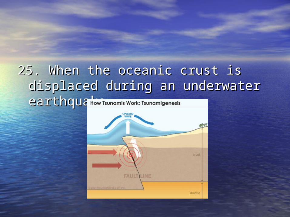
25. When the oceanic crust is 25. When the oceanic crust is displaced during an underwater displaced during an underwater earthquake.earthquake.

26. Oldest rocks are farthest from the 26. Oldest rocks are farthest from the mid-ocean ridge; youngest rocks are mid-ocean ridge; youngest rocks are closest from the mid-ocean ridge.closest from the mid-ocean ridge.

27. 27.
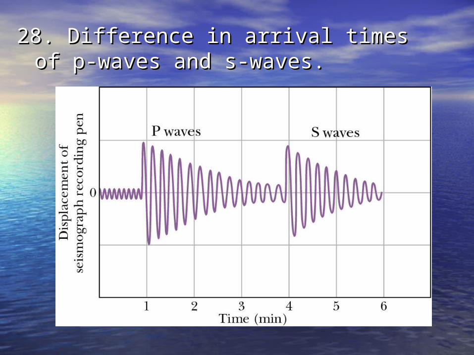
28. Difference in arrival times of p-28. Difference in arrival times of p-waves and s-waves.waves and s-waves.
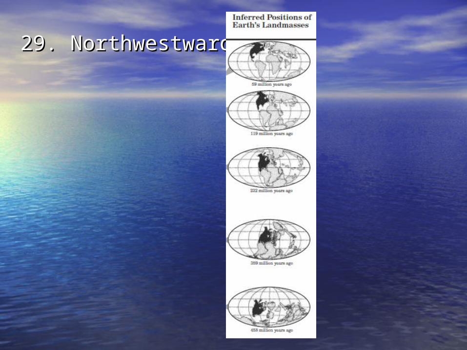
29. Northwestward.29. Northwestward.
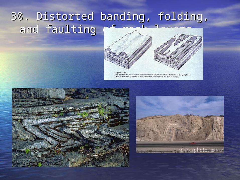
30. Distorted banding, folding, and 30. Distorted banding, folding, and faulting of rock layers.faulting of rock layers.
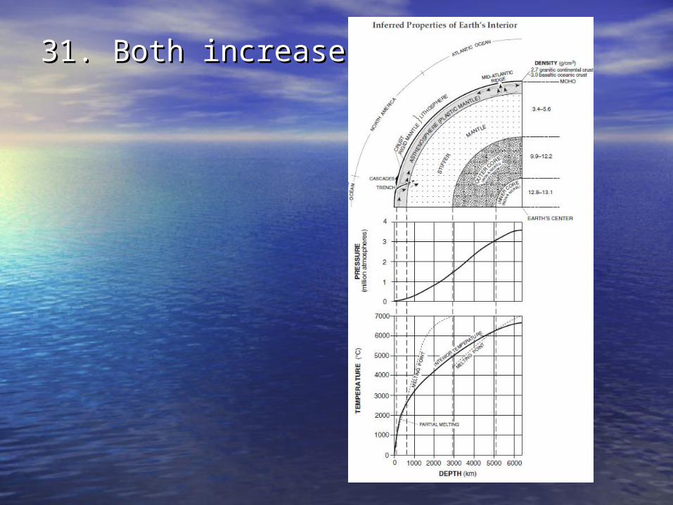
31. Both increases.31. Both increases.

32. 1200 32. 1200 °C°C

33. 33. Theory of Continental DriftTheory of Continental Drift – all the – all the continents were once joined together continents were once joined together as Pangaea and separated to their as Pangaea and separated to their current positions. current positions.
EvidencesEvidences::1) Continents coastlines fit together like 1) Continents coastlines fit together like
a puzzle.a puzzle.2) Same fossils (plant and animal), 2) Same fossils (plant and animal),
rocks types, mountain ranges, and rocks types, mountain ranges, and glacial striations found on different glacial striations found on different continents.continents.
3) Coal deposits found in Antarctica but 3) Coal deposits found in Antarctica but can only form in tropical regions.can only form in tropical regions.

34. Alfred Wegener34. Alfred Wegener
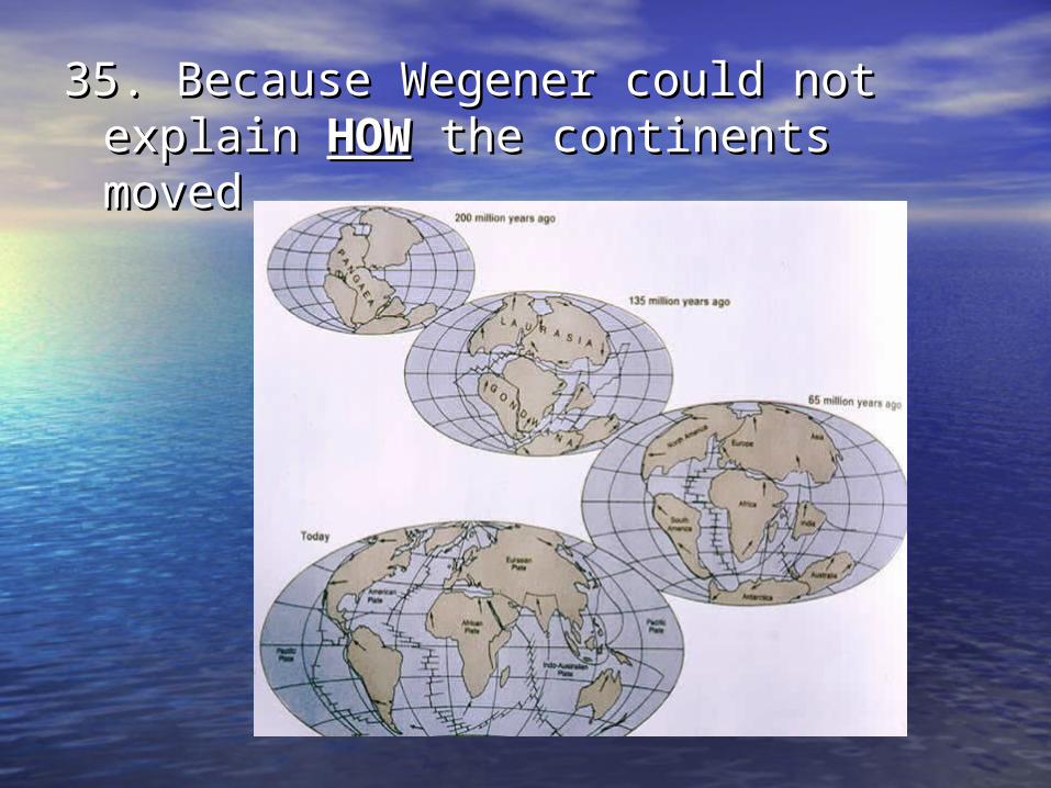
35. Because Wegener could not 35. Because Wegener could not explain explain HOWHOW the continents moved. the continents moved.
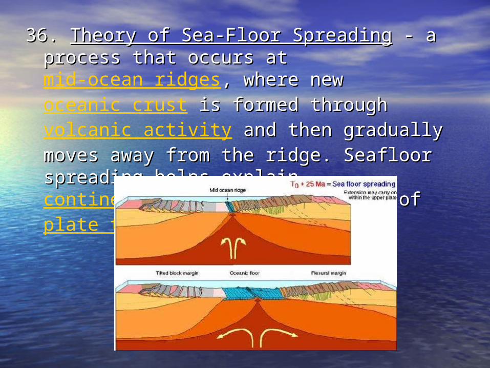
36. 36. Theory of Sea-Floor SpreadingTheory of Sea-Floor Spreading - a - a process that occurs at process that occurs at mid-ocean ridges, , where new where new oceanic crust is formed is formed through through volcanic activity and then and then gradually moves away from the ridge. gradually moves away from the ridge. Seafloor spreading helps explain Seafloor spreading helps explain continental drift in the theory of in the theory of plate tectonics..

Evidences for sea-floor spreading:Evidences for sea-floor spreading:1) Pillow shaped basaltic rocks and rift 1) Pillow shaped basaltic rocks and rift
valleys on either side of the mid-valleys on either side of the mid-ocean ridge.ocean ridge.
2) Same magnetic pole patterns on 2) Same magnetic pole patterns on either side of the mid-ocean ridge.either side of the mid-ocean ridge.
3) Age of rocks on either side of the 3) Age of rocks on either side of the mid-ocean ridge increases from the mid-ocean ridge increases from the ridge towards the coastlines.ridge towards the coastlines.
4) Discovery of deep-ocean trenches.4) Discovery of deep-ocean trenches.
37. 37. Theory of Plate TectonicsTheory of Plate Tectonics - states - states that Earth’s crust is made up of about that Earth’s crust is made up of about a dozen rigid sections called a dozen rigid sections called lithosphericlithospheric plates (~100km thick, plates (~100km thick, includes crust and rigid upper includes crust and rigid upper mantle); these plates are “floating” mantle); these plates are “floating” on the asthenosphere and are on the asthenosphere and are moving slowly by giant convection moving slowly by giant convection currents in the mantle currents in the mantle (asthenosphere section). (asthenosphere section). *This theory *This theory combines Continental Drift and Sea-combines Continental Drift and Sea-Floor Spreading theories to explain Floor Spreading theories to explain HOW the Earth’s has changed. HOW the Earth’s has changed.
Evidences for Plate Tectonics:Evidences for Plate Tectonics:
1. Tilted strata1. Tilted strata
2. Faulting of rocks 2. Faulting of rocks
3. Folding of rocks 3. Folding of rocks
Ex. Anticlines and SynclinesEx. Anticlines and Synclines
4. Displaced fossils 4. Displaced fossils
5. Heat Flow 5. Heat Flow
6. Hot Spots6. Hot Spots
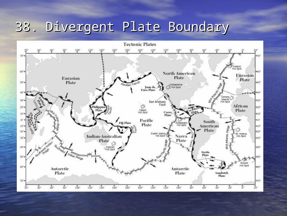
38. Divergent Plate Boundary38. Divergent Plate Boundary

39. Mountains and Trenches are 39. Mountains and Trenches are created by convergent plate created by convergent plate boundaries.boundaries.
Valleys (hot spots, mid-ocean ridges) Valleys (hot spots, mid-ocean ridges) are created by divergent plate are created by divergent plate boundaries.boundaries.
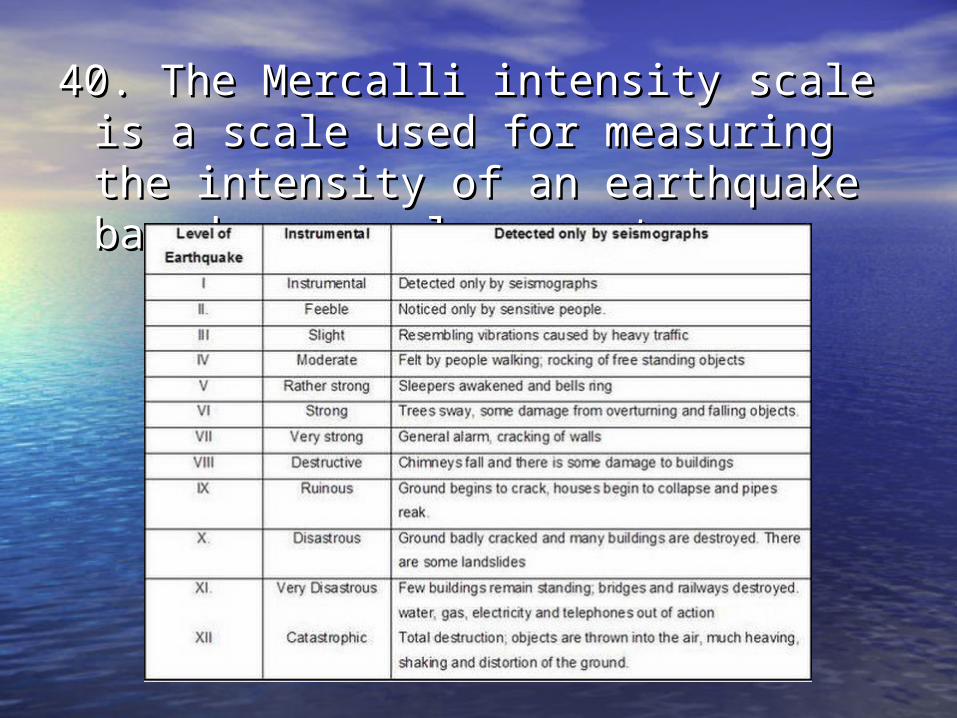
40. The Mercalli intensity scale is a 40. The Mercalli intensity scale is a scale used for measuring the scale used for measuring the intensity of an earthquake based on intensity of an earthquake based on people reports.people reports.
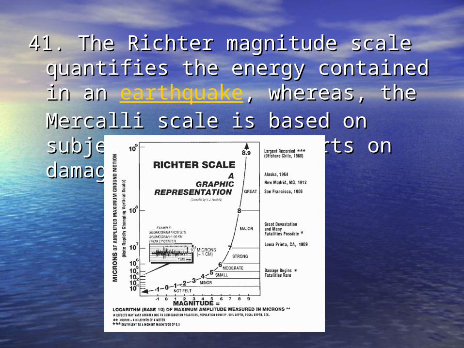
41. The Richter magnitude scale 41. The Richter magnitude scale quantifies the energy contained in an quantifies the energy contained in an earthquake, whereas, the Mercalli , whereas, the Mercalli scale is based on subjective people scale is based on subjective people reports on damage. reports on damage.

42. Richter scale.42. Richter scale.

• Be able to:Be able to:• Find Average Chemical Composition of Earth’s Find Average Chemical Composition of Earth’s
Crust, Hydrosphere, and Troposphere Crust, Hydrosphere, and Troposphere ESRTESRT p.1 p.1• Interpret Tectonics Plates map - be able to Interpret Tectonics Plates map - be able to
determine latitude and longitude of different determine latitude and longitude of different features (Ex. Hot spots, Trenches, etc.) and identify features (Ex. Hot spots, Trenches, etc.) and identify which lithospheric plates (countries) are at which lithospheric plates (countries) are at convergent, divergent, or transform boundaries- convergent, divergent, or transform boundaries- ESRTESRT p.5 p.5
• Determine the Inferred Positions of Earth’s Determine the Inferred Positions of Earth’s Landmasses – Landmasses – ESRTESRT p.9 p.9
• Interpret the Interior Layers of Earth – Interpret the Interior Layers of Earth – ESRTESRT p.10 p.10• Interpret Earthquake P-Wave and S-Wave Travel Interpret Earthquake P-Wave and S-Wave Travel
Time to determine epicenters – Time to determine epicenters – ESRTESRT p.11 p.11• Determine the Selected Properties of Earth’s Determine the Selected Properties of Earth’s
Atmosphere -– Atmosphere -– ESRTESRT p.14 p.14