1 european perspectives on geostationary microwave sounding bizzarro bizzarri cnr istituto di...
TRANSCRIPT

1
European Perspectives on Geostationary Microwave Sounding
Bizzarro Bizzarri
CNR Istituto di Scienze dell’Atmosfera e del Clima, Roma, Italy
Phone +39.06.4426.1604, Fax +39.06.4423.7615, E-mail [email protected]
Content
• European undertaking in the geostationary orbit
• Principle of MW precipitation & sounding from geostationary orbit
• GOMAS (Geostationary Observatory for MW Atmospheric Sounding)
2nd GOES Users Conference, Boulder CO, USA, 1-3 October 2002

2
European undertaking in the geostationary orbit
• Meteosat 1 was launched on 23 November 1977, first of a pre-operational series (Meteosat 1, 2 and 3).
• Meteosat 4 was launched on 6 March 1989, first of an operational series (Meteosat 4, 5, 6 and 7) to be used until 2005.
• All these are spinning satellites, equipped with a 3-channel VIS/IR imager.
• MSG 1 was launched on 28 August 2002, first of a Meteosat Second Generation series (Meteosat 8, 9, 10 and 11) to be used until 2020.
• These are still spinning satellites, equipped with a 12-channel VIS/IR imager (SEVIRI) and an Earth Radiation Budget radiometer (GERB).
• Mission definition of post-MSG, or Meteosat Third Generation, has started, in view of a first launch in 2015. A 1st User Consultation Workshop was held on 13-15 November 2001.

3
PARAMETER OBSERVABLE FROM GEO OBSERVABLE FROM LEO
Temperature and
humidity profile
IR emission from different atmospheric layers by
spectroscopy.
Emission from different layers
by MW/Sub-mm radiometry.
IR/MW emission from different atmospheric
layers by spectroscopy.
Occultation of signals from GPS received by a
LEO satellite.
Windprofile
Motion of water vapour patches by IR imaging
spectrometers with frequent observing cycle.
Tracers motion (clouds, water vapour and ozone
patches)
Tracers motion (clouds, water vapour and ozone patches)
measured byBackscattered light from
aerosol eddies orDerived by 4-D assimilation
of frequent temperature / humidity profiles.
measured by VIS/IR image sequences..
overlapping VIS/IR images at high
latitudes.
molecules by Doppler lidar.
Cloud pattern,
type, and evolution;
water vapour growth
Frequent measurement of scattered and emitted
radiation in several VIS/IR channels covering atmospheric windows and water vapour absorption
bands.
Scattered and emitted radiation in
several VIS/IR channels covering
atmospheric windows and water vapour absorption bands.
Precipitation rate
Derived by 4-D assimilation of frequent temperature /
Correlation with cloud top ice as observed by VIS/IR
MW/Sub-mm radiation in
absorption bands
Correlation with lightning intensity and
Correlation with lightning intensity and
MW backscattering from raindrops by radar -
Profile provided.humidity profiles. radiometry. - Gross profile
possible.flashes/time in a given area.
flashes/time in a given area.
MW radiation in atmospheric windows.
INSTRUMENTIR sounding
spectrometer.VIS/IR imaging
radiometer.MW/Sub-mm radiometer.
Lightning mapper.
LEO technique also applicable to GEO.
LEO instruments not applicable to GEO.
FEASIBILITYDemonstration mission being developed in US.
Current practise. Improvements feasible.
To be demonstrated.
Demonstrated in LEO.
Current or demonstrated.
Demonstrated or planned.
COLOUR CODE Marginal compliance Poor compliance Fair compliance Good compliance Excellent compliance

4
Requi- G l o b a l N W P RegIonal N W P N o w c a s t i n g
rement Unit W M O E U M W M O E U M W M O E U M Target Threshold Target Threshold Target Threshold Target Threshold Target Threshold Target Threshold
x km 50 100 5 100 10 50 3 50 5 50 1 5
r.m.s. mm/h 0.1 1 0.1 1 0.1 1 0.1 1 0.1 1 1 10
t h 1 12 1 12 0.5 6 0.5 3 0.08 1 0.03 0.3
delay h 1 4 1 4 0.5 2 0.5 1 0.08 0.5 0.03 0.1
WMO and EUMETSAT requirements for precipitation observation
(WMO representative of current or near-future, EUM of > 2015)

5
The problem of measuring precipitation
The most long-standing practise makes use of VIS/IR image sequences from GEO:
• The observing frequency is suitable (15 min with MSG)
• The measurement is strongly indirect (VIS/IR only “sees” the cloud top)
• The applicability is mostly addressing convective precipitation.
From LEO, MW images are used (from SSM/I, TRMM, in the near future GPM):• The measurement is direct for low frequencies (10 GHz), less for high frequencies (90 GHz)
• The applicability is better for convective precipitation, but extends to all precipitation types
• The frequency, with GPM, will be around 3 hours
• Global scale will be served optimally, regional scale to a fair extent
• For the mesoscale, fusion between LEO MW images and GEO VIS/IR images will be attempted.
The ideal would be to extend the MW imagery technique to the geostationary orbit, but:• The antenna diameter for a 10-km resolution is 15 m at 90 GHz, 35 m at 37 GHz, 70 m at 19 GHz
• Polarisation diversity is not practical from the geostationary orbit (large and variable -angle).
GEO requires using higher frequencies and exploiting a different physical principle.

6
The physical principle for measuring precipitation from GEO
MW observation from LEO makes use of “atmospheric windows”:• Most common frequencies: 6 GHz, 10 GHz, 19 GHz, 23 GHz, 37 GHz, 90 GHz, 150 GHz• Dual polarisation for roughness effects (over the sea) and scattering from ice (over land).
The proposed principle for GEO exploits absorption bands:• Profiles of temperature and humidity are measured by more bands at different frequencies• Profiles observed exploiting bands of different frequencies are differently sensitive to clouds• Absorption bands at very high frequencies enable using antennas of affordable size• It is not necessary to differentiate polarisations• In absorption bands the measurement is equally effective over sea and land.
The precipitation measurement passes through the sounding one, therefore:• Many more channels are needed, very narrow (< 1 ‰), with SNR > 100• In exchange, one simultaneously gets:
- the temperature vertical profile (also inside clouds)
- the humidity vertical profile (also inside clouds)
- the columnar content (or gross profile) of liquid water in the cloud
- the columnar content (or gross profile) of ice water in the cloud
- the precipitation.

7
Multi-channel image from an airborne radiometer (Gasiewski et al, 1994). Note:
• In absorption bands (183 and 325 GHz) increasing cloud impact moving from the peak to the window (from 183 1 to 183 3 and 183 7; and from 325 1 to 325 3 and 325 9);
• In windows (89, 150, 183 7, 220 e 325 9) increasing cloud impact with increasing frequency.

8
Precipitation images from a cold front on October 7, 1998: NEXRAD precipitation map smoothed to 15 km resolution (left image), and NOAA/AMSU precipitation map obtained using a neural net retrieval technique (right image) (Staelin and Chen, 2000).

9
NOAA-15 AMSU-B 183+/-7 GHz 15-km resolution imagery of small rain cells over the Eastern U.S on August 2, 2000 (from Staelin and Chen, 2000).

10
Comparison between the 118/54 GHz profile ratio from the NAST-M microwave radiometer being flown on the NASA ER-2 aircraft and simultaneous EDOP Doppler radar reflectivity observation. Hurricane Bonnie at 17 GMT on August 26, 1998 (Tsou et al, 2001). The ratio 118/54 is unit in the absence of precipitation or above the precipitation cell, and reduces in the presence of precipitation because of higher attenuation from drops and impact from ice scattering at the higher frequency. The agreement between the two vertical cross-sections is striking. Horizontal maps of this information from GEO at 15 min intervals, will resemble a proxy rain radar operating over continental field of view, particularly over oceans and mountainous terrain.

11
Atmospheric spectrum in the MW/Sub-mm range (Klein and Gasiewski, 2000).
Preferred bands - for O2 (temperature): 54 GHz, 118 GHz, 425 GHz; for H2O: 183 GHz, 380 GHz.

12
Incremental Weighting Functions (IWF) for the selected channels in the bands of oxygen (54, 118 and 425 GHz) and of water vapour (183 and 380 GHz). Note that the sensitivity of 380 and 425 GHz drastically drops in lower troposphere (Klein and Gasiewski, 2000).

13
Retrieval errors for bands 118, 183, 380 e 425 GHz, stand-alone or associated to an IR sounder of the IASI or AIRS class (“GAIRS”). Temperature on the left hand, humidity on the right. On the left hand, GAIRS + 118 + 425 is compared to GAIRS alone and to 118 + 425 alone. For reference, the EOS/Aqua AIRS + AMSU/A + AMSU/B complex also is shown (Blackwell and Staelin, 1996).

14
Initiatives for MW/Sub-mm sounding from GEO
Early proposals:• Staelin D.H. and P.W. Rosenkranz, editors, 1978: "Applications Review
Panel: High resolution passive microwave satellites". A report to NASA.
• Chedin A., D. Pick and R. Rizzi, 1985: "Definition study and impact analysis of a microwave radiometer on a geostationary spacecraft". A report to ESA.
Fresh start:• Staelin D.H., J.P. Kerekes and F.J. Solman III, 1997: "Final Report of the
Geosynchronous Microwave Sounder Working Group". A report to NOAA/NESDIS.
• Staelin D.H., A.J. Gasiewski, J.P. Kerekes, M.W. Shields and F.J. Solman III, 1998: "Concept proposal for a Geostationary Microwave (GEM) Observatory". A proposal to NASA and NOAA.
• Bizzarri B., 2000: "MW/Sub-mm sounding from geostationary orbit". A report to EUMETSAT.
Current projects:• GEM (Geostationary Microwave observatory).
• GOMAS (Geostationary Observatory for Microwave Atmospheric Sounding).
15
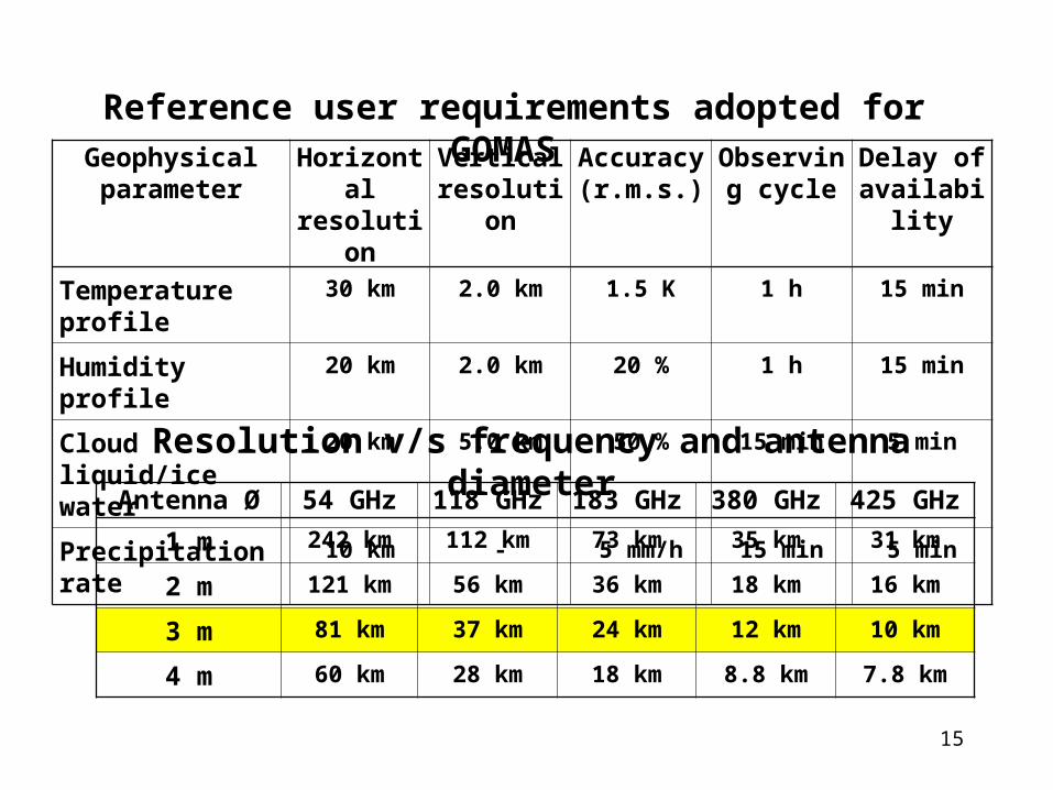
Geophysicalparameter
Horizontal resolution
Vertical resolution
Accuracy (r.m.s.)
Observing cycle
Delay of availability
Temperature profile 30 km 2.0 km 1.5 K 1 h 15 min
Humidity profile 20 km 2.0 km 20 % 1 h 15 min
Cloud liquid/ice water 20 km 5.0 km 50 % 15 min 5 min
Precipitation rate 10 km - 5 mm/h 15 min 5 min
Antenna Ø 54 GHz 118 GHz 183 GHz 380 GHz 425 GHz
1 m 242 km 112 km 73 km 35 km 31 km
2 m 121 km 56 km 36 km 18 km 16 km
3 m 81 km 37 km 24 km 12 km 10 km
4 m 60 km 28 km 18 km 8.8 km 7.8 km
Reference user requirements adopted for GOMAS
Resolution v/s frequency and antenna diameter
16
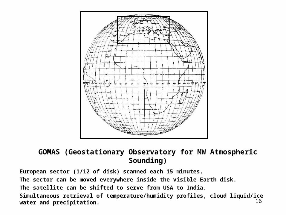
GOMAS (Geostationary Observatory for MW Atmospheric Sounding)
European sector (1/12 of disk) scanned each 15 minutes.
The sector can be moved everywhere inside the visible Earth disk.
The satellite can be shifted to serve from USA to India.
Simultaneous retrieval of temperature/humidity profiles, cloud liquid/ice water and precipitation.

17
(GHz)
(MHz)
Product resolution
IFOV
s.s.p.
Required NET (K)
Expected
NET (K)
Peak of IWF
(GHz)
(MHz)
Product resolution
IFOV
(s.s.p.)
Required NET (K)
Expected
NE T (K)
Peak of IWF
56.325 50 0.6 0.15 27 km 183.310 0.300 300 0.6 0.45 10 km
56.215 50 0.5 0.15 23 km 183.310 0.900 500 0.6 0.35 8.5 km
56.025 250 0.5 0.07 17 km 183.310 1.650 700 2 x 2 pixels 0.5 0.29 7 km
55.520 180 0.4 0.08 13 km 183.310 3.000 1000 (20 km) 24 km 0.3 0.24 6 km
54.950 300 6 x 6 pixels 0.4 0.06 10 km 183.310 5.000 2000 0.4 0.17 5 km
54.400 220 (60 km) 81 km 0.3 0.07 8 km 183.310 7.000 2000 0.6 0.17 4 km
53.845 190 0.3 0.08 5 km 183.310 17.000 4000 0.3 0.18 surface
53.290 360 0.3 0.06 3 km 380.197 0.045 30 0.3 2.36 15 km
52.825 300 0.2 0.06 2 km 380.197 0.400 200 0.5 0.91 13 km
51.760 400 0.1 0.05 1 km 380.197 1.500 500 2 x 2 pixels 0.5 0.58 11 km
50.300 180 0.1 0.08 surface 380.197 4.000 900 (20 km) 12 km 0.5 0.43 9 km
118.750 0.018 6 0.5 1.32 34 km 380.197 9.000 2000 0.4 0.29 7 km
118.750 0.035 12 0.6 0.93 29 km 380.197 18.000 2000 0.3 0.36 6 km
118.750 0.080 20 0.6 0.72 24 km 424.763 0.030 10 0.5 3.40 34 km
118.750 0.200 100 0.5 0.32 19 km 424.763 0.070 20 0.6 2.41 28 km
118.750 0.400 200 3 x 3 pixels 0.5 0.23 15 km 424.763 0.150 60 0.6 1.39 23 km
118.750 0.700 400 (30 km) 37 km 0.5 0.16 12 km 424.763 0.300 100 3 x 3 pixels 0.5 1.08 18 km
118.750 1.100 400 0.4 0.16 9 km 424.763 0.600 200 (30 km) 10 km 0.5 0.76 15 km
118.750 1.500 400 0.4 0.16 7 km 424.763 1.000 400 0.5 0.54 12 km
118.750 2.100 800 0.3 0.11 5 km 424.763 1.500 600 0.5 0.44 8 km
118.750 3.000 1000 0.2 0.10 3 km 424.763 4.000 1000 0.4 0.34 5 km
118.750 5.000 2000 0.1 0.07 surface
380.197 18.000 2000 1 pixel 12 km 1.0 0.72 6 km
424.763 4.000 1000 (10 km) 10 km 1.0 1.02 5 km
NET compliance code Compliant Nearly compliant Compliant on 2 x or 1 h Candidate to be dropped
Radiometric performance assessment for 15 min observing cycle

18
Azimuth Motor& Compensator
Elevation Motor& Compensator
Nodding / MorphingSubreflector
Thin Struts
Space Calibration Tube
BackupStructure
3” Thick Composite Reflector
50-430 GHz Feeds
Receiver Package
The GOMAS instrument with its 3-m antenna

19
S-Band Antenna for TT&C S-band antenna
for LRIT
NORTH DIRECTION
Space Calibration
Tube
NADIR
Solar Wing
3 -meterAntenna
Star Sensors
S-band Antennafor TT&C
The GOMASsatellite
• Mass: 860 kg (“dry": 430 kg)
• Electrical power: 500 W• Volume: 3.0 x 3.0 x 3.0 m3
• Data rate: 128 kbps (S-band, compatible with MSG LRIT).

20
Team leader Institute Team leader Institute
Umberto AMATO CNR Istituto Applicazioni della Matematica, Napoli, Italy Paul MENZEL NOAA/NESDIS Office of Research and Application, Madison Wis., USA
John BATES NOAA/NESDIS, National Climatic Data Center, Asheville NC, USA Jungang MIAO Institute of Environmental Physics, University of Bremen, Germany
Wolfgang BENESCH Deutscher Wetterdienst, Offenbach, Germany Alberto MUGNAI CNR Istituto Scienze dell'Atmosfera e del Clima, Roma, Italy
Stefan BÜHLER Institute of Environmental Physics, University of Bremen, Germany Paolo PAGANO Servizio Meteorologico dell'Aeronautica, Roma, Italy
Massimo CAPALDO Servizio Meteorologico dell'Aeronautica, Roma, Italy Jean PAILLEUX Météo France, Toulouse, France
Marco CERVINO CNR Istituto Science dell'Atmosfera e del Clima, Bologna, Italy Juan PARDO Instituto de Estructura de la Materia, Madrid, Spain
Vincenzo CUOMO CNR Istituto Metodologie Avanzate di Analisi Ambientale, Potenza, Italy Federico PORCU' Department of Physics, University of Ferrara, Italy
Luigi De LEONIBUS Servizio Meteorologico dell'Aeronautica, Roma, Italy Catherine PRIGENT Dep.nt de Radioastronomie Millimetrique, Observatoire de Paris, France
Michel DESBOIS CNRS Laboratoire de Météorologie Dynamique, Palaiseau, France Franco PRODI CNR Istituto Science dell'Atmosfera e del Clima, Bologna, Italy
Stefano DIETRICH CNR Istituto Science dell'Atmosfera e del Clima, Roma, Italy Rolando RIZZI Department of Physics, University of Bologna, Italy
Frank EVANS University of Colorado, Atmospheric & Oceanic Sciences, Boulder Co., USA Guy ROCHARD MétéoFrance, Centre de Météorologie Spatiale, Lannion, France
Laurence EYMARD CNRS Centre études Environnement Terrestres et Planétaires, Vélizy, France Hans Peter ROESLI MétéoSuisse, Locarno-Monti, Switzerland
Albin GASIEWSKI NOAA Environmental Technology Laboratory, Boulder Co., USA Carmine SERIO Dip.nto Ingegneria e Fisica Ambiente, University of Basilicata, Potenza, Italy
Nils GUSTAFSSON Swedish Meteorological and Hydrological Institute, Norrköping, Sweden William SMITH NASA Langley Research Center, Hampton VA., USA
Georg HEYGSTER Institute of Environmental Physics, University of Bremen, Germany Antonio SPERANZA Hydrographic and Mareographic Service, Roma, Italy
Marian KLEIN NOAA Environmental Technology Laboratory, Boulder Co., USA David STAELIN MIT Research Laboratory of Electronics, Cambridge MA., USA
Klaus KÜNZI Institute of Environmental Physics, University of Bremen, Germany Alfonso SUTERA Department of Physics, University of Roma, Italy
Vincenzo LEVIZZANI CNR Istituto Science dell'Atmosfera e del Clima, Bologna, Italy Jung-Jung TSOU NASA Langley Research Center, Hampton VA., USA
Gian Luigi LIBERTI CNR Istituto Science dell'Atmosfera e del Clima, Bologna, Italy Chris VELDEN Cooperative Institute for Meteorological Satellite Studies, Madison Wis.,USA
Ernesto LOPEZ-BAEZA Dep.nt of Thermodynamics, Faculty of Physics, University of Valencia, Spain Guido VISCONTI Department of Physics, University of L'Aquila, Italy
List of Proponents of GOMAS (undertaking to implement the scientific programme)
P.I.: Bizzarro BIZZARRI, for the CNR Istituto Scienze dell'Atmosfera e del Clima, Roma, Italy
21
Conclusions
• Strong requirements exist for frequent precipitation observation.
• From GEO, a new physical principle needs to be exploited.
• GOMAS is proposed as a demonstration mission.
• It would be a precursor for future operational applications.
• From the technical standpoint, and building on the studies conducted in the U.S. on GEM, it is believed that no enabling technology is currently missing.
• The GOMAS satellite could be developed in time for a launch before 2010, in phase with GPM and possible overlap with GIFTS.
• It would provide simultaneous retrieval of: - temperature profile (x 30 km) - humidity profile (x 20 km) - cloud liquid/ice water total column and gross profile (x 20 km) - precipitation rate (x 10 km)
each 15 minutes ! over 1 / 12 of the disk covering sea and land !