1 february 2016 coal of africa limited mineral resources
TRANSCRIPT

017-8100-3349/2/AUSTRALIA
1 February 2016
Coal of Africa Limited
Mineral Resources and Ore Reserves Update
Key Highlights
Makhado Project Resource and Reserve Update
Coal Resources and Ore Reserves completed for Makhado:
Measured, Indicated and Inferred Mineral Resource of 796Mt (Gross Tonnes in Situ)
Probable Ore Reserve estimate of 188 Mt (Mineable Tonnes in Situ)
All Coal Resources and Reserves reported in this Announcement are identical to 27 June 2013 estimations,
which were reported in accordance with the JORC Code (2004 Edition).
The estimation of the Makhado Mineral Resources and Ore Reserves was completed by The MSA Group (Pty)
Ltd (MSA).
Vele Colliery Resource and Reserve Update
Coal Resources and Ore Reserves completed for the Vele:
Measured, Indicated and Inferred Mineral Resource of 794Mt
Proven Ore Reserve estimate of 24Mt and Probable Ore Reserve estimate of 301 Mt
Variation between the 2012 Coal Resource and Reserve statements (which were reported in accordance with
the JORC Code (2004 Edition) and the Coal Resource and Reserve statements in this Announcement (which
were reported in accordance with the JORC Code (2012 Edition) is the result of depletion that occurred during
the operational period of Vele Colliery.
The estimation of the Vele Colliery Mineral Resources and Ore Reserves was completed by VBKom Consulting
(Pty) Ltd (VBKom).
Greater Soutpansberg Project (GSP) Resource Update
Coal Resources completed for the GSP:
Measured, Indicated and Inferred Mineral Resource of 7,161Mt (Gross Tonnes In Situ)
No changes have been made to the GSP Coal Resources since the 29 February 2012 statement, which was
compiled in accordance with the JORC Code (2004 Edition)
The estimation of the GSP Coal Resources on 29 February 2012 were independently signed off by Glanvill
GeoConsulting (Pty) Ltd (Liz de Klerk), Group Geologist of CoAL (John Sparrow) and Venmyn Rand (Pty) Ltd.
The updated 31 December 2015 Coal Resources in this Announcement have been presented by Venmyn
Deloitte (Pty) Ltd (Venmyn Deloitte).
OVERVIEW
On 21 December 2015, Coal of Africa Limited (ASX: CZA) (CoAL or Company) announced that it had lodged an offer
document in relation to its offer to acquire the entire issued and to be issued share capital of Universal (the Offer),
with the Australian Securities and Investments Commission. Under the terms of the Offer, CoAL is offering to
2
017-8100-3349/2/AUSTRALIA
acquire each Universal Share held, subject to eligibility, for A$0.20 in cash and 1 New CoAL Share or a non-
converting, secured Loan Note with a principal amount of A$0.25 per Loan Note (the Acquisition).
The Acquisition, constitutes a reverse takeover for CoAL under the AIM Rules for Companies (AIM Rules) and in
fulfilment one of the conditions precedent of the Acquisition CoAL will be releasing an admission document
(Admission Document) and seeking shareholder approval for the Acquisition at a general meeting. The Company
anticipates that the Admission Document will be published on 1 February 2016 and posted to shareholders on 2
February 2016.
The Admission Document necessitated the preparation of independent competent person's reports in relation to
each of CoAL and Universal’s material projects and as a result, the Company’s Mineral Resources and Ore Reserves
for its material projects (Makhado Project, Vele Colliery and GSP), have been updated from the Australasian Code
for Reporting of Exploration Results, Mineral Resources and Ore Reserves, 2004 Edition (JORC 2004) to Mineral
Resources and Ore Reserves reported in accordance with the Australasian Code for Reporting of Exploration
Results, Mineral Resources and Ore Reserves, 2012 Edition (JORC 2012), necessitating the need for this
Announcement. The Abridged versions of the competent person’s reports will be included in the Admission
Document with full and unadjusted versions of the competent person’s reports. The reports are available on the
Company’s website (www.coalofafrica.com) and this Announcement should be read in conjunction with those
reports.
MAKHADO PROJECT MINERAL RESOURCE AND ORE RESERVE UPDATE
CoAL has completed a review and update to its Mineral Resource and Ore Reserve for the Makhado Project. The
review was undertaken by the MSA, which was commissioned to prepare an independent competent person’s
report in accordance with the AIM Rules in connection with the Admission Document.
MSA reviewed the estimation procedures and independently validated the results. MSA agrees with the Coal
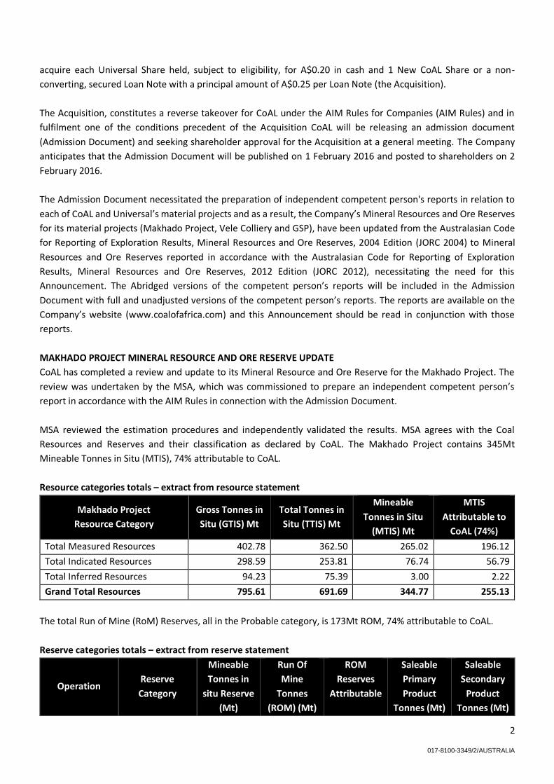
Resources and Reserves and their classification as declared by CoAL. The Makhado Project contains 345Mt
Mineable Tonnes in Situ (MTIS), 74% attributable to CoAL.
Resource categories totals – extract from resource statement
Makhado Project
Resource Category
Gross Tonnes in
Situ (GTIS) Mt
Total Tonnes in
Situ (TTIS) Mt
Mineable
Tonnes in Situ
(MTIS) Mt
MTIS
Attributable to
CoAL (74%)
Total Measured Resources 402.78 362.50 265.02 196.12
Total Indicated Resources 298.59 253.81 76.74 56.79
Total Inferred Resources 94.23 75.39 3.00 2.22
Grand Total Resources 795.61 691.69 344.77 255.13
The total Run of Mine (RoM) Reserves, all in the Probable category, is 173Mt ROM, 74% attributable to CoAL.
Reserve categories totals – extract from reserve statement
Operation Reserve
Category
Mineable
Tonnes in
situ Reserve
(Mt)
Run Of
Mine
Tonnes
(ROM) (Mt)
ROM
Reserves
Attributable
Saleable
Primary
Product
Tonnes (Mt)
Saleable
Secondary
Product
Tonnes (Mt)

3
017-8100-3349/2/AUSTRALIA
to CoAL
(74%)
East Pit
Probable
94.59 86.80 64.23 14.77 24.33
Central Pit 53.47 49.07 36.31 6.75 10.56
West Pit 40.19 36.88 27.29 4.12 9.65
Grand Total Reserves 188.25 172.76 127.83 25.64 44.54
JORC 2012 Mineral Resource and Ore Reserve Summary for the Makhado Project
Mineral Resource Summary
Geology and Geological Interpretation
The Makhado Project area is located in the Tshipise South subdivision of the greater Soutpansberg Coalfield, South
Africa. The Makhado Project is characterised by a number of seams which occur within a 30 to 40 metre thick
carbonaceous zone of the Madzaringwe Formation. All seams comprise interbedded carbonaceous mudstones and
coal. The coal component is usually bright and brittle and contains a high proportion of vitrinite. The seams dip
northwards at approximately 12°. Six potential mining horizons or seams which were identified by CoAL namely:
Upper Seam, Middle Seam, Middle Lower Seam, Bottom Upper Seam, Bottom Middle Seam and Bottom Lower
Seam.
Sampling and Sub-Sampling Techniques
The source data that provided input into the Coal Resource include the following:
• 316 NQ-size diamond core holes drilled by Iscor before. 2007 No wireline logging was completed on these
boreholes.
• 4 PQ3-size diamond core holes drilled by Rio Tinto between 2006 and 2007 with wireline logging data.
These boreholes were excluded from the estimation.
• 172 PQ3-size triple tubed diamond cores holes and 24 large diameter drill (LDD) holes drilled by CoAL
between 2008 and 2010. Both diamond core holes and the LDD have wireline logging data.
• 13 percussion holes drilled by CoAL in 2010 which have wireline logging information.
CoAL conducted whole core sampling and sample intervals were selected on the basis of the geophysical logs.
Samples were numbered from the base upwards and correspond to the same stratigraphic interval in every
borehole. CoAL has identified six potentially mineable seams within the Coal Zone.
Samples are submitted to the laboratory where quality assurance and quality control (QAQC) is checked at the
laboratory by plotting ash versus calorific value (CV) and all samples with a correlation less than 0.90 are re-
analysed.
Drilling Techniques
The first 25 boreholes drilled by CoAL were pre-collared to a depth of 10m with a tri-cone bit prior to diamond drill
coring, in order to penetrate the bouldery regolith that characterises the area. From July 2009, this practice was
abandoned in favour of coring from surface, with steel casing installed to the base of weathering, in order to
investigate occurrences of surface regolith and calcrete. All boreholes were drilled using triple tube techniques in
order to minimise loss of core, particularly of fines. The core size was changed from HQ3 to PQ3 after the initial 25
exploration boreholes in order to obtain more sample material and maximise core recovery. The only percussion

4
017-8100-3349/2/AUSTRALIA
or open hole drilling conducted within the Makhado Project area is that by CoAL in 2010. This programme included
13 straight percussion holes within the area identified for the bulk sample (boxcut).
Criteria Used for Classification
The Resources were presented in the following standard manner for the Makhado Project:
Gross Tonnes in Situ (GTIS), application of mineral tenure boundaries and a 0.5 m seam thickness cut-off.
Total Tonnes in Situ (TTIS), application of geological losses to GTIS; and
MTIS, application of basic mining parameters to TTIS. An example of this would be the application of a minimum
seam cut-off for underground mining or the block layout losses for an opencast operation. The MTIS Resources
have only considered potential open-cast coal mining to a maximum depth of 200 m.
A maximum spacing of 500m between points of observation has been used to determine a measured resource
Category. A maximum spacing of 1,000m between points of observation has been used to determine an indicated
resource Category. A maximum spacing of 4,000m between points of observation has been used to determine an
inferred resource category for this estimation. A measured, indicated and inferred resource has been identified in
the Makhado Project area reflecting the competent person’s level of confidence in the seam structure and quality
continuity, based on the data currently available.
Sample Analysis Method
Samples from the first 25 boreholes drilled by CoAL were sent to the South African Bureau of Standards (SABS)
laboratory in Secunda. SABS is accredited (No T0230) through the South African National Accreditation System
(SANAS) and SABS/ISO/IEC 17025:2005. However, due to delays in the reporting of analytical results, CoAL relocated
all unprocessed samples from SABS to Inspectorate which is also a SANAS accredited laboratory (No T0313). Since
July 2009, two laboratories have been used by CoAL. Core exploration samples have been sent to the CAM Analytical
Laboratories (Pty) Ltd (CAM). CAM is accredited (No.T0476) through SANAS.
Estimation Methodology
All historical and previous exploration data has been collated, by CoAL, into a SableTM database. This database was
used, by CoAL, in the estimation of the coal resources of the Makhado Project. Both the physical and quality
parameters of the various seams were modelled. Grids with a 20m mesh were estimated using the MinexTM general
purpose gridding function using a 2.5km search radius.
The model of the physical parameters of the seam was cut along any significant structures, whilst the quality
parameters were modelled across it. All physical and quality parameters were plotted and visually inspected to
ensure they were acceptable for geological interpretation. In addition, the caking property of coke, phosphorous
content and total sulphur content have been assessed across the deposit using results obtained from approximately
60% of the CoAL boreholes.
Cut-Off Grade(s)
A 30 m depth cut-off was applied to remove any oxidised material. Only the ore within the pit shells was considered
in the estimate. In addition all coal with Volatile content <20% (air dried) excluded from the estimate.
Mining and Metallurgical Methods and Parameters
The following cut-offs or limits are applied to the Resources:
the Resource blocks are limited according to the boundaries of the respective NOPRs;

5
017-8100-3349/2/AUSTRALIA
the Resource blocks are limited to the seam sub-crop;
the Resource blocks are limited to the Resource extrapolation limits;
a minimum seam thickness limit of 0.5 m is applied prior to the reporting of GTIS;
a limit of oxidation of 30 m, based on the actual results from the bulk sampling pit indicate 18m;
a limit of 20% volatile matter. All material less than 20% volatiles were excluded;
a limit of 50 m around all known geological structures and dykes;
maximum depth of 200 m for open cast Resources in the calculation of MTIS; and
geological losses of 10%, 15% and 20% are applied to Measured, Indicated and Inferred Resources, respectively,
prior to the reporting of TTIS. These losses take into account any unforeseen geological features, such as dykes
and faults, which have not been identified in the drilling and which may have a negative impact on the Coal
Resources. The percentages applied increase with decreasing borehole spacing.
Mineral reserves summary
Material Assumptions, Outcomes from 2013 Feasibility Study and Economic Assumptions
A Definitive Feasibility Study (DFS) was completed by CoAL with the assistance of a number of leading independent
industry consulting firms. The DFS defined a 16 year LOM with mining expected to take place at an average rate of
12.6Mtpa ROM in order to produce 2.3Mtpa of hard coking coal and 3.2Mtpa of thermal coal, at a steady state. The
resource will be mined on an opencast basis with the potential for expansion into underground. The DFS
recommendation is that the plant will be owner operated and the mining contractor operated.
An export/ domestic hard coking coal price of USD225 per tonne for the primary product, at an exchange rate of
ZAR7 to the USD. A domestic thermal coal price of ZAR250 per tonne for the middlings product was not considered
in the evaluation during the Whittle Pit Optimisation to define the pit size as this exercise was carried out prior to
the decision to produce the middlings fraction. The inclusion of the middlings fraction would result in upside
potential to the project. Commodity prices and exchange rates used to estimate the economic viability of Coal
Reserves are based on long term forecasts applied at the time the estimate was completed. Even though the
forecast coal prices have retreated in the short term, the significant depreciation of the South African Rand to
~ZAR14.1 to the USD results in no material changes. An average total cash operating cost of ZAR244 per RoM tonne
was utilised in the DFS.
Criteria Used for Classification
The minimum requirements for the conversion of Coal Resources to Coal Reserves and the resultant declaration
and signoff of a Reserve statement requires that a mine plan has been prepared and that the modifying factors
have been considered and applied to the Resource for the conversion process. The modifying factors include
consideration of the mining, processing, metallurgical, infrastructure, economic, marketing, legal, environment,
social and government factors in order to derive an ore Reserve which is demonstrated to be economically
extractable in present day conditions. The Coal Reserves were declared on the basis of the [2013] DFS on the
Makhado Project.
In the case of the Makhado Project, the Competent Person has classified all the Makhado Reserves into the Probable
category, although 85% of the Resources from which they are derived, are classified as Measured Resources. The
reason for this classification relates to the uncertainty around the yields.
Mining Methods and Mining Assumptions

6
017-8100-3349/2/AUSTRALIA
The Makhado Project will mine the coal from three opencast pits (referred to as the West Pit, Central Pit and East
Pit) located east of the N1 National Road and to the south of Provincial Road D745. Intermediate crushers will be
located to the south of each of these pits. The coal processing plant will be located to the south of the East Pit, so
as to minimise the haulage distances. The East Pit will be the largest pit with the greatest portion of the Coal
Reserves.
Processing Methods and Processing Assumptions
DRA Mineral Projects (Pty) Ltd (DRA) was contracted by CoAL to carry out the portion of the DFS covering the coal
handling and processing plant (CHPP) for the Makhado Coal Project. The test work on the bulk sample was
instrumental in determination that a consistent product with ash content closer to 10% ash can be achieved with a
two stage DMS circuit comprising of high gravity (HG) wash followed by a low gravity (LG) wash. The HG wash in
this configuration plays a destoning role prior to final separation in the LG washing stage. The test work was based
on a single stage wash at a medium RD of 1.34, it is expected that a product with ash content closer to 10% ash can
be achieved with a two stage DMS circuit comprising of high gravity (HG) wash followed by a low gravity (LG) wash.
The HG wash in this configuration plays a destoning role prior to final separation in the LG washing stage.
Cut-Off Grade(s)
A 30 m depth cut-off was applied to remove any oxidised material. Only the ore within the pit shells was considered
and all coal with Volatile content <20% (air dried) excluded.
Estimation Methodology
The Coal Reserves were based upon the block model prepared by Mr B Bruwer, VBKom’s Senior Mining Engineer,
the information to which was originally sourced from the Minex model dated 31st August 2011. The MTIS resources
are notably larger than the MTIS reserves, due to the fact that the latter only considers coal that lies within the pit
shells developed during the mine design. It excludes material that cannot be accessed due to economic or practical
mining considerations, for example the resource situated below Mudimeli Village or within the 100yr floodline of
the Mutamba River.
Material Modifying Factors and Approvals
The Makhado Project footprint is in an environmentally and ecologically sensitive area. Thus the necessary diligence
was exercised when consideration was given to the location, placement and orientation of the mine infrastructure
area facilities. Energy efficiency is considered when orientating and designing buildings. Office buildings are where
possible, north-facing.
The Integrated Water Use License has been granted by the Department of Water and Sanitation.
Please refer to the abridged competent person’s report included in the Admission Document and the full,
unadjusted competent person’s report on the Company’s website and the detailed information given in the JORC
Table 1 at the end of this Announcement in Appendix 1.
VELE COLLIERY MINERAL RESOURCE AND ORE RESERVE UPDATE
CoAL has completed a review and update to its Mineral Resource and Ore Reserve for Vele Colliery. The review was
undertaken by VBKom, which was commissioned to prepare an independent competent persons report in
accordance with the AIM Rules in connection with the Admission Document. The following technical discussion is
extracted from the abridged Mineral Resource and Reserve estimate of the Vele Competent Person’s Report (CPR)

7
017-8100-3349/2/AUSTRALIA
which is contained in the Admission Document with the full, unadjusted competent person’s report available on
the Company’s website. It starts off with the abbreviated Resource and Reserve tables below:
Resource categories totals (all tonnages reported is 100% attributable to CoAL) – extract from resource statement
Vele Colliery
Resource Category
Gross Tonnes in Situ
(GTIS) Mt
Total Tonnes in Situ
(TTIS) Mt
Mineable Tonnes in
Situ (MTIS) Mt
Total Measured Resources 148.17 133.35 86.11
Total Indicated Resources 426.85 362.83 200.3
Total Inferred Resources 218.93 175.15 75.15
Grand Total Resources 793.95 671.32 361.57
Variation between the 2012 Coal Resource statements and the Coal Resource statements in this Announcement is
the result of depletion that occurred during the operational period of Vele Colliery.
Reserve categories totals (all tonnages reported is 100% attributable to CoAL) – extract from reserve statement
Operation Reserve Category
Mineable
Tonnes in situ
Reserve (Mt)
Run Of Mine
Tonnes (ROM)
(Mt)
Saleable
Primary
Product
Tonnes (Mt)
Saleable
Secondary
Product
Tonnes (Mt)
Opencast Proven 23.81 25.28 2.70 8.34
Opencast &
Underground Probable
301.37 266.11 28.47 87.82
Grand Total Reserves 325.18 291.39 31.18 96.16
JORC 2012 Mineral Resource and Ore Reserve Summary for the Vele Colliery
Mineral Resource Summary
Geology and Geological Interpretation
The Karoo age Limpopo Coalfield is generally fault bounded, with the southern extent of the basin controlled by
erosion. The Main Coal Zone is present in the Madzaringwe Formation, which is approximately 15m thick. Three
distinct coal horizons occur in the Middle Ecca Group, locally referred to the Top, Middle and Bottom Coal Horizons.
All three coal horizons comprise interbedded coal and mudstone units with varying coal quantities and qualities.
The coal deposition of the Vele Colliery occurred within and intra-continental basin bounded by extensional
faulting. Major faults have been interpreted, through field observations and geophysics, for the area. The faults
divide the deposit in blocks with varying seam depths.
A serious of dolerite dykes trend predominantly east west across the project colliery area, the largest is estimated
to be more than 15m thick. These dykes were emplaced during the extension tectonics that formed the intra
continental basin. The dykes did not have significant displacement associated with their emplacement but have
resulted in minor de-volatilisation of coal in the immediate contact.

8
017-8100-3349/2/AUSTRALIA
The Top, Middle and Bottom seams were all intersected through drilling and mining activities within the Vele
Colliery area. Top and Bottom seams can further be differentiated into a Top Lower, Top Middle, Top Upper,
Bottom Lower and Bottom Upper. The Top Middle and Top Upper are not considered economic.
Sampling and Sub-Sampling Techniques
Sampling of whole core samples (in accordance to SANS10320:2004) was done in intervals of between 50cm and
150cm. Samples were initially sent to SABS laboratory in Secunda, then to Inspectorate M&L, and since December
2008, all samples have been sent to the CAM in Polokwane, Limpopo Province. All the laboratories are SANAS
accredited for coal analyses. CoAL geologists do random validations of the results by doing basic tests on cumulative
results and testing the values with neighbouring drill holes and the seam characteristics.
Drilling Techniques
Drill holes incorporated into the geological model are primarily diamond core drilling with secondary percussion
drilling to verify the structure of the boxcut area, as well as understanding the structural and quality continuity.
The last phase of drilling was LDD holes for metallurgical test work for the plant modification project. All logging of
drill hole data was done in accordance to best practices and has been consistence since CoAL’s involvement in the
project. The data is capture on a SABLETM Database, which is checked by a competent geologist on a regular basis.
All holes drilled during CoAL’s involvement has down-hole geophysics for seam correlation and structural
interpretations. A total of 573 drill holes have been used in the geological model and the Coal Resource estimation.
Criteria Used for Classification
The first Coal Resource classification was based on the spacing between points of observation (point with structural
and / or quality data). This method stated that points of observation spaced at 500m are Measured Resources,
Indicated Resources were spaced at 1000m and Inferred Resources the spacing was 3km.
Coal petrography was done on the coal seams from the Vele Colliery and it indicates that the coal is a medium rank,
high vitrinite content, and C-grade bituminous coal. The coal falls into a semi-soft coking coal category. Figure 1
indicates the coal quality of the Vele Colliery in relation to petrographic images.
Figure 1
Sample Analysis Method

9
017-8100-3349/2/AUSTRALIA
All analytical test work and associated sample preparation is performed to internationally acceptable standards.
All standard procedures are available on request. In short, the following processes were followed by the
laboratories for the preparation and analysis of slim core samples:
Air dry samples received
Determine the raw relative density (RD) of the sample
Crush sample to -25mm and screen out the -0.5mm
Preform a raw coal proximate analysis, CV and total Sulphur (S) on the +0.5mm and -0.5mm size
fractions
Analyse the +0.5mm to -25mm fraction for phosphorous (P2O5)
Conduct float/sink analyses on the +0.5mm to -25mm size fraction at densities ranging from 1,30t/m3
to 1.80t/m3 in increments of 0.05t/m3.
Preform proximate analyses, CV, total sulphur and phosphorous for each float fraction and the sink
product from the 1.80 RD fraction
The float fractions at RD 1.30, 1.35, 1.40 and 1.45 the Free Swelling Index (FSI) and Roga Index was
determined
Drop shatter tests and wet tumble tests are methods to simulate the breakage that occurs in coal processing, prior
to classification (separation into different size fractions) and washing in the preparation plant. The process applies
repeated dropping of lump coal to establish a RoM size description, followed by a wet tumbling phase where the
RoM coal is tumbled in a drum with steel blocks and water to simulate the breakage, which occurs in pumping,
cycloning, and screening phases in the preparation plant. The procedure is as follows:
Standard 20 drops of unbroken coal from two meters
Dry tumble broken coal with 10 steel cubes for three minutes
Wet tumble coal with 18 steel cubes (for a 50kg sample mass) for five minutes
Thereafter the resulting coal package was screened into a +0.25mm to -2mm, +2mm to -12.5mm, +12.5mm to -
25mm and +25mm to -50mm size fractions. Each fraction was submitted for float/sink analyses. The float/sink
analyses was performed on the following RD’s (t/m3); 1.35, 1.38, 1.40, 1.42, 1.45, 1.50, 1.60, 1.80, 2.00 and 2.30.
Proximate analyses were performed on each float fraction.
Estimation Methodology
Over the existence of the project, various coal deposit models have been prepared for the Vele Colliery. In
September 2010, The Mineral Corporation constructed a 3D Minex TM digital model. Mr J Sparrow, a competent
geologist, prepared the current model used for resource estimation and mine planning and designs. Mr Sparrow is
CoAL’s chief consulting geologist and has been involved in the project since 2011. The latest geological model was
created in Minex TM software. The model incorporates all available historical and recent drilling and other geological
information up to January 2015. The model is based on the Mineral Corporation’s model of 2010, with minor
changes based on geological information collected subsequently to the completion of the Mineral Corporation’s
model. From previous audits and reviews by reputable independent consultants, there is a high level of confidence
in the geological model. The upper surface of the model is a digital terrain model (DTM) based on the light detection
and ranging (LIDAR) survey conducted with a high level of spatial accuracy. Figure 2 provides the topography as a
DTM. Dolerite dykes and fault planes were incorporated in the 3D structural model. The structural model assisted
in identifying areas for opencast mining and underground mining.

10
017-8100-3349/2/AUSTRALIA
Figure 2
Cut-Off Grade(s)
The following cut-offs were applied before the GTIS were calculated for the Vele Colliery:
The coal was reported separately for the mining right and prospecting right respectively
The Coal Resource Blocks were limited to the Mineral Right boundaries
The Coal Resources are limited to the seam sub-crop
Coal Resource blocks are limited to the extrapolation limits in the model
Boundary pillars of 50m wide on either side of geological structures and dykes
Coal Resource blocks are limited to the base of oxidation
Coal Resource blocks are limited to the 100m year flood line for the Limpopo River
A seam thickness cut-off of 0.5m are applied
Volatiles less than 18% (dry ash free) to ensure devolatilised coal was excluded
The following cut-off was applied to calculate TTIS:
Geological losses (confidence in structural continuity and oxidation profiles) of 10%, 15% and 20% are
applied to Measured, Indicated and Inferred Coal Resources respectively.
The following cut-off was applied to calculate MTIS resources:
A minimum seam height of 1.4m and a maximum seam height of 4.5m have been applied to the Bottom
Lower Seam for the underground resources.
Mining and Metallurgical Methods and Parameters
Mining, Processing and Environmental factors as per the studies discussed under Technical studies have been
applied to determine the reasonable and realistic prospects for eventual economic extraction. No resources were
excluded based on these criteria.
Mineral reserves summary
Material Assumptions, Outcomes from various feasibility studies and Economic Assumptions

11
017-8100-3349/2/AUSTRALIA
CoAL has done various studies to different degrees of detail (comparable with pre-feasibility study levels), and it is
the opinion of VBKom that the studies are sufficient in detail to warrant the conversion of Coal Resources to Coal
Reserves.
Vele Colliery is an existing operation with Coal Reserves reported for an opencast mine plan and an underground
mine plan. It is important to note that the current business case is only considering a portion of the opencast
reserve blocks (16 years life of mine (LOM)) for financial modelling. The additional Coal Reserves outside the 16-
year period does not significantly influence the NPV of the project. The current business case scenario is referred
to as the Plant Modification Project (PMP).
A high-level financial model was completed where the mining areas that were additional RoM reserve tonnes
(excluded from the financial model). The additional reserves were scheduled consecutively and the results
indicated viability with long-term price forecasts. Due to the planned mining rate, mining the additional reserve
tonnages will be only after the Plant Modification Project’s 16 year LOM.
Criteria Used for Classification
The first Coal Resource classification was based on the spacing between points of observation (point with structural
and / or quality data). This method stated that points of observation spaced at 500m are Measured Resources,
Indicated Resources were spaced at 1000m and Inferred Resources the spacing was 3km.
In order to bring the Coal Resource statement in line with the guidelines of the JORC Code 2012 a correlation cross
was drilled to determine the optimal spacing between drill holes to determine lateral continuity. It was determined
that 500m is sufficient for structural estimation and 1000m for quality estimations. No variography was done, but
resource estimation were done at different grid spacing, which indicated little change to the resource tonnage and
quality within the advised spacing. This indicates that the current classification used by Vele Colliery is a
conservative approach and is acceptable for the current Resource Reporting cycle.
Other criteria was also considered for the Coal Resource Classification criteria, i.e. confidence in drill hole position,
confidence in coal analyses and confidence in structural interpretation of a drill hole. The reserve includes 23.81Mt
proven and 301.37 Mt probable in-situ coal [TTIS]
Mining Methods and Mining Assumptions
After various trade-of studies between only opencast mining, combination of opencast and underground mining
and underground mining the best option was the combination of the two methods. The opencast mining was seen
as a concern in such an environmentally sensitive area, but was opted for due to the economics of the opencast
reserves. Underground mining will target the Bottom Lower Seam only, using a board and pillar mining pattern.
Underground mining has only been considered suitable in those areas where the depth of the roof of the Lower
Seam generally exceeds 60m in depth due to the weak coal strength and poor overburden stability. The board and
pillar mining layout should be achieving a relatively high extraction rate of approximately 65% by virtue of the low
seam height to depth ratio.
The opencast mine will be accessed through two separate boxcuts, one in the central pit and one in the northern
pit. The opencast mining process as designed will not significantly differ or change after the plant modification
process is implemented.
Base case after Plant Modification Project is 2.6Mtpa of RoM at an average strip ratio of 3.6 over a period
of 16 years

12
017-8100-3349/2/AUSTRALIA
The Top Lower, Middle, Bottom Upper and Bottom Lower seams will be extracted
Mining is based on a truck and shovel operation (contract mining) with the following equipment (as used
for the boxcut):
Processing Methods and Processing Assumptions
The current process plant and the proposed modification to the plant is well known technology in the coal mining
industry. The metallurgical test work is based on drop shatter and wet tumble test. The yield distribution per sink
fraction was used to optimise the product mix and the coal preparation plant. The samples tested are
representative for the PMP project. The current plant consists of the following main sections:
Temporary crushing and screening plant;
de-stoning plant (modular);
secondary washing plant (modular);
spiral plant (modular); and
product and discard stockpiles
general plant services and
a slurry pond
The efficiency of the spiral plant, the size distribution produced by the crusher section and the higher revenue
available by producing a dual stream product is the basis for the Plant Modification Project.
A Front End Engineer & Design (FEED) study was performed by Sedgman to modify the existing coal handling and
processing (CHPP) plant to process 500tph RoM and produce a semi soft coking coal and a thermal coal product.
The plant upgrade study included:
A new RoM dual tip hopper, with an 800mm top size,
A new feeder breaker to size the RoM coal to nominal 50mm
New and extending conveyors to transport coal between new plant modules, discard and stockpiles,
A feed bin for surge capacity
Upgrading of the de-stoning plant
New discard bin and discard extraction system
Tertiary screening plant for nuts & peas as well as stacking system
Modification to coking coal plant feed system (larger openings, vibrating feeder chutes)
Upgrading the existing metallurgical DMS cyclone
New thermal coal stockpile facilities
The upgrade for the fines beneficiation by incorporation of reflux classifier and flotation circuit, and
Dewatering using a high frequency screen for thermal coal and screen bowl centrifuge for coking coal.
Dust and fire suppressing systems as well as integrated control and communication system.
Cut-Off Grade(s)
The conversion of Coal Resources to Coal Reserves includes the application of cut-offs. The cut-offs can be
geological, mining related or related to the processing plant. Mining related cut-offs are as follows for the
underground mine at Vele Colliery:
Bord and pillar dimensions (65% coal extraction) and bottom lower seam targeted only
Minimum seam thickness of 1.4m and a maximum seam thickness of 4.5m

13
017-8100-3349/2/AUSTRALIA
Most of the cut-off grades were applied to the Coal Resource in the calculation MTIS resources. The only other
mining cut-off applied is that the Bottom Lower Seam has to be more than 60m underground to be extracted. This
is required to extract the Coal Reserves safely.
Cut-offs related to the opencast mining:
Mining layout
Estimation Methodology
The Coal Resource estimation is done by the gridding algorithm that is part of the MINEXtm, which is a well-
established method for estimation in the coal industry. No domaining was done for the quality estimate, but was
applied with the seam thickness estimation based on faults and dykes
The Mineral Resource estimate was previously done by the Mineral Corporation and Venmyn Rand and was
reviewed by VBKom. The mine extracted 144kt of coal and this was considered in the estimation of the Coal
Resources.
It is noted:
There is no by-products present in the coal deposit.
Sulphur and phosphorous was analysed for and is estimated within the geological model. Sulphur is
reported in the Coal Resource Statement, but phosphorous is excluded due to the low concentrations
present.
The model is based on a grid and not blocks.
All units i.e. seams are modelled based on drill hole seam intersections and down-hole geophysical
survey.
There is a correlation between ash and CV in the deposit and is used as verification of estimated results.
All estimations were constrained within the defined coal seams.
Coal is defined as material below 60% ash content. This is the only form of capping applied.
The data is validated through cross sections and various coal quality plots.
Material Modifying Factors and Approvals
Regulatory Approvals
The application and approval of mineral rights falls under the Department of Mineral Resources and is governed by
the Mineral Resources and Petroleum Development Act 28 of 2002 (MRPDA). Entities (individuals or companies)
apply through regional offices for Prospecting or Mining Rights. Prospecting Rights are granted for an initial five
year period where after is can be renewed for an additional three years. Mining Rights are applied for the period
of operation up to final closure for a maximum period of 30 years.
Mineral and Petroleum Resources Development Act, 28 of 2008 (MPRDA)
Vele Colliery was granted its New Order Mining Right (NOMR) on 19 March 2010, on the following farms:
Overvlakte 125 MS (Portions 3, 4, 5, 6, 13 and Remaining Extent)
Bergen Op Zoom 124 MS
Semple 145 MS
Voorspoed 836 MS

14
017-8100-3349/2/AUSTRALIA
Vele Colliery is in possession of an approved Environmental Management Programme (EMPr) in terms of Section
39 of the MPRDA.
National Environmental Management Act, 109 of 1998 (NEMA)
In July and October 2011, Vele Colliery was granted Section 24G Environmental Authorisations, in terms of the
NEMA. In 2014 the company applied for an amendment to the Environmental Authorisation, which was approved
as granted on 16 January 2015, and subsequently appealed. On 19 November 2015, the Minister dismissed the
appeal lodged against the Vele Colliery’s amended Environmental Authorisation.
National Water Act, 36 of 1998 (NWA)
In terms of the NWA, On 13 Jan 2015 the water use licence was renewed (for a further 20 years) and amended.
Furthermore, the IWUL has been amended in line with the requirements for the Plant Modification Project (PMP)
at the Colliery. During H2 2015, the Company commenced a process to obtain approval relating to a non-perennial
stream diversion. This decision is anticipated in H2 2016. Once this regulatory approval in respect of the Colliery
has been received, the final decision to proceed with the PMP will be placed before the board, which will include
an assessment of forecast global coal prices.
National Environmental Management Waste Act, 59 of 2008 (NEMWA)
The DEA has confirmed that no NEMWA authorisations are required for Vele Colliery. All licences and permits are
in place at Vele Colliery, and the colliery continues to meet all its regulatory obligations while during operations
and under the current care and maintenance scenario, while the upgrade to the plant via the PMP is being planned.
Continues Environmental programs, monitoring, meetings, test studies and assessments
Notwithstanding that Vele Colliery was placed on Care & Maintenance in October 2015, the colliery continues to
meet all its regulatory obligations as it would under operational status. As such, continuous assessments,
inspections and monitoring and site visits continue as required. A number of continuous studies, assessments,
inspections and monitoring meetings are currently conducted/undertaken by specialists/appointed teams and
reported to the relevant licencing and permitting authorities, where required, and are kept updated and
maintained.
Mining Dilution Factors
The Practical yield includes organic plant efficiencies and yield reduction due to dilution for the different streams
to be produced.
Mining recovery factors used (DCF mining layout only)
Additional Geological losses of 5% was subtracted from resource tonnes in the Plant Modification Project opencast
layout plan, as coal affected by small dykes and faults has been identified and removed from the plan, as well as
possible oxidised coal mining strips near the sub-outcrop. A mining recovery of 92% was used in the Phase 1
opencast plan, as an existing opencast exists, with proven extraction. The high recovery is also possible due to free
digging of the coal using a backhoe excavator, enabling lower losses and dilution from blasting.
Calculation of RoM in designed mining blocks of DCF model:
Description: Factor Value Unit
In Situ Tonnes (> 0.5m seam width): 100 t

15
017-8100-3349/2/AUSTRALIA
Description: Factor Value Unit
After geological losses: × 0.95 95 t
After mining losses: × 0.92 87.4 t
RoM: 91.8 t
Primary product: 9.8 t
Primary Product effective yield: 10.7 %
Secondary Product: 30.3 t
Secondary Product effective yield: 33 %
Minimum mining widths used
A minimum mining width of 0.5m of coal seam was used, as multiple layers of seam exist, and blasting of waste and
selective loading methods, enabled the selectivity in seam mining. The PMP LOM schedule accommodated multiple
active coaling seams, requiring more active strips, and the extra waste stripping required to achieve this is included
in the mining plan. Mining strips of varying length were divided into blocks with a width of 50m and length varying
between 50-100m. Blasting blocks were identified based on seam contacts, and no SMU or bench height or bench
elevation was traded off. The underground mine tonnages that was reported by CoAL applied a minimum 1.4m
mining height and 4.5m maximum mining height for underground mining of Bottom Lower coal seam.
Infrastructure requirements
Vele Colliery is an existing opencast operation, currently under care and maintenance. Coal is delivered to
customers through the existing infrastructure, available in Musina, which is able to support the operation. The
nearest town is Musina, which is the seat of the local Municipality with a history of mining activity and there are
active mines in the region. Services include schools, rail linkage, a hospital, wide tar roads and electricity from the
national grid. Distribution and transport of coal include Trucking to siding, FEL (Front End Loader) load train trucks.
The product investigated was selling a SSCC product to a local (South African client) where transport is provided to
the siding at Musina, and Thermal export coal (Free on Board (FOB) at Maputo harbour).
GSP MINERAL RESOURCE UPDATE
CoAL has completed a review and update to its Mineral Resource for GSP. The review was undertaken by Venmyn Deloitte (Pty) Ltd, which was commissioned to prepare an Independent Competent Persons report in accordance with the AIM Rules in connection with the Admission Document. The GSP assets are divided into four groups of projects that are further divided into individual sections, all of which are located in the Limpopo province, South Africa:-
the Mopane Project, comprising the Voorburg and Jutland sections;
the Generaal Project, comprising the Generaal and Mount Stuart sections;
the Chapudi Project, comprising the Chapudi, Chapudi West and Wildebeesthoek sections; and
the Telema and Gray project, comprising Telema and Gray (formerly Makhado Extension).
The Coal Resources for the GSP assets were originally estimated and signed off by CoAL's Competent Person, Mr J Sparrow (Pr.Sci.Nat.) (CoAL's Group Geologist), Venmyn Rand (Pty) Ltd and independent contractor Liz de Klerk (Pr.Sci.Nat) (Glanvill Geoconsulting) on 29 February 2012. .

16
017-8100-3349/2/AUSTRALIA

17
017-8100-3349/2/AUSTRALIA
There has been no material change in the Coal Resource statement since 29 February 2012 and it has accordingly
been re-presented without change in this 2015 CPR.
JORC 2012 Mineral Resource Summary for the GSP Assets PROJECT SECTION RESOURCE
CATEGORY GROSS
TONNES IN SITU (GTIS)
TOTAL TONNES IN SITU (TTIS)
MINEABLE TONNES IN SITU (MTIS)
COAL ATTRIBUTABLE
%
COAL ATTRIBUTABLE
(GTIS)
Mopane Voorburg Measured 109,435,158 98,491,000 94,915,200 *74-100% 105,669,749.86
Makhado Ext. Telema and
Gray
42,244,854 38,020,200 36,240,800 100% 42,244,854.00
TOTAL/WT. AVE MEASURED 151,680,012 136,511,200 131,156,000 *74-100% 147,914,603.86
Mopane Voorburg Indicated 125,033,852 106,271,000 100,500,000 74-100% 119,624,989.06
Makhado Ext. Telema and Gray
29,581,152 25,141,000 23,225,000 100% 29,581,152.00
TOTAL/WT. AVE INDICATED 154,615,004 131,412,000 123,725,000 *74-100% 149,206,141.06
Mopane Voorburg Inferred 36,238,997 28,920,000 23,940,000 *74-100% 31,651,715.60
Generaal Mount Stuart
407,162,828 325,690,000 55,460,000 100% 407,162,828.00
Makhado Ext. Telema and
Gray
12,301,228 9,820,000 7,320,000 100% 12,301,228.00
Chapudi Chapudi 6,399,023,436 5,119,130,000 1,318,420,000 74% 4,735,277,342.64
TOTAL/WT. AVE INFERRED 6,854,726,489 5,483,560,000 1,405,140,000 *74-100% 5,186,393,114
GRAND TOTAL RESOURCES 7,161,021,505 5,751,483,200 1,660,021,000 *74-100% 5,483,513,859
*CoAL has a 100% interest in all right holders(s) except those acquired as part of the Chapudi acquisition transaction. In these right holders
CoAL has a 74% interest.
Mineral Resource Summary
Geology and Geological Interpretation
The Soutpansberg Coalfield is preserved within a down-faulted, graben structure, at the north-eastern edge of the
Kaapvaal Craton. The Karoo-aged coal bearing sediments occur as alternating mudstone laminae and coal bands
within the Middle Ecca or Madzaringwe Formation, dipping between 3° and 20° northwards. Coal horizons are
divided into six potentially economic seams, namely the Upper, Middle Upper, Middle Lower, Bottom Upper
Bottom Middle and Bottom Lower seams.
The region is faulted, becoming more severe in the far east, and has throws of between 60m and 200m, leading to
the formation of horst and graben structures. A further subordinate set of faults, orientated at right angles to that
mentioned above, subdivides the eastern portion of the Soutpansberg Coalfield region into a set of irregular blocks.
The greater Soutpansberg Coalfield has been divided into three subdivisions:-
the Mopane Coalfield, between the towns of Mopane and Waterpoort in the west that hosts the Voorburg
and Jutland Sections;
the Tshipise Coalfield, stretching east of Mopane in the area of the town of Tshipise that hosts the Telema
and Gray Section in the Tshipise South Coalfield and the Mount Stuart Section in the Tshipise North
Coalfield. The Generaal, Chapudi, Chapudi West and Wildebeesthoek Sections are located within an
extension of the Tshipise Coalfield, also known as the Waterpoort Coalfield; and
the Pafuri Coalfield, terminating at the northern limit of the Kruger National Park in the east.

18
017-8100-3349/2/AUSTRALIA

19
017-8100-3349/2/AUSTRALIA
Sampling and Sub-Sampling Techniques
The majority of borehole quality data available for the GSP assets has been obtained from historical drilling
databases. As such the drilling, logging, sampling and surveying methods and standards used is predominantly
unknown.
From the information that is available, it is evident that the different companies adopted different sampling
methods depending on the agenda and only partial coal quality data is available.
Iscor typically took 13 samples from the top to the base of the coal bearing strata, which were numbered
consecutively in this order. Rio Tinto sampled on a ply-by-ply basis.
More detailed information is available for the Seam 6 coking sampling at Chapudi carried out by Rio Tinto. Initially
waste bands and associated coal horizons <50cm were omitted. This methodology then changed where Seam 6 was
sampled over its entire thickness including partings. Finally a more modern and conventional sampling technique
was adopted where all coal and waste intervals were sampled separately allowing recombination of the samples
into a bulk seam, or alternatively into selected mining horizons.
Reverse Circulation (RC) chips were not sampled.
Drilling Techniques
Historically drilling on the GSP assets has been performed by:-
Rapburn (1970s) – early exploration and reconnaissance;
Iscor (1939-1981) – early exploration and reconnaissance;
Trans Natal Mining Company (1970s) – reconnaissance;
Rio Tinto (2002-2009) – reconnaissance and confirmatory; and
CoAL (2009-2012) – confirmatory, infill and resource definition.
Numerous borehole types and sizes have been utilized including NQ (Iscor), 8-inch (Rio Tinto), PQ3 (CoAL), T6146
(CoAL) and RC (Rio Tinto and CoAL). Little is known about the drilling techniques employed during the historical
exploration phases, however, it is assumed that the drilling methods were conventional and pre-date the more
efficient triple-tube wireline techniques that are commonly employed today.
No core recovery information is available for the historical boreholes (except Chapudi).
It is believed that except for deflections all boreholes were drilled vertically and downhole geophysical data is
available for the more recent Rio Tinto drilling programmes and the CoAL boreholes.
Venmyn Deloitte believe that the drilling techniques used historically would have been to a professional standard
considering the companies involved, however cognisance has been taken regarding the lack of information
regarding protocols and core recoveries.
More information is known about the drilling techniques used by Rio Tinto on the Chapudi Project, which was
conducted from 2005 to 2009 on Seam 6 for coking potential. The diamond drilling (PQ3 and large diameter) was
undertaken in four stages and geotechnical and initial lithological logging was carried out whilst the core was in the
split inner tube. Detailed lithological logging was carried out once the depths were finalised after reconciliation with
the geophysical wireline logs and during the sampling process. The detailed coal logging was carried out at the
refrigerator.
For all exploration procedures followed by CoAL for the 2012 drilling programmes the reader is referred to the
protocol document prepared by Venmyn Rand (Pty) Ltd for CoAL on 10 April 2012 named “Coal Exploration Best
Practise Guideline for GSP Prepared for Coal of African Limited (COAL)”, Venmyn Deloitte reference number D1140.

20
017-8100-3349/2/AUSTRALIA
Criteria Used for Classification
The classification, by CoAL, into the various resource categories is primarily based upon the relative spacing of
points of observation with both quantitative and qualitative results. Venmyn Deloitte is confident, having reviewed
the data, that the logging, sampling, data density and distribution are suitable for the Coal Resource estimation.
Resources have been categorised, by CoAL, as Measured, Indicated or Inferred according to observation point halos
in accordance with JORC reporting standards. The resources have not been sub-divided into the proposed
underground and opencast sectors. In order to classify the coal resources, a halo diagram is prepared using only
the boreholes with quality and quantity results. Whilst the halo diagrams are considered when determining
resource classification, cognisance is also taken of the lack of sample information and where deemed appropriate
the resource classification has been restricted to Inferred.
Sample Analysis Method
Historical samples were predominantly analysed for washability at a float density of 1.40 and only a few boreholes
contain raw analyses. The Iscor holes were sampled and sent to their in-house laboratory for analysis. Samples from
the Rio Tinto drilling campaign were analysed at ALS Brisbane (ISO 17025 accredited) and the accredited SABS
laboratory in Secunda (No T0230).
All of the samples taken from the CoAL drilling programmes were sent to Inspectorate’s SANAS accredited
laboratory in Polokwane (No T0476). The ISO and South African National Standard (SANS) has a standard set of
tests and methods that are used for coal analyses by South African laboratories.
An array of different analytical methods have been used across the GSP assets on a mixture of both raw and washed
coal samples, including:
proximates, CV, TS;
ultimate analysis;
forms of sulphur;
ash fusion temperature ;
chlorine;
Hardgrove Grindability Index;
Free Swelling Index;
Grey King Index;
Roga Index;
ash analysis;
petrographic analysis;
dilatation;
fluidity;
vitrinite reflectance; and
drop shatter tests.
Estimation Methodology
The orebody models for the GSP assets have been prepared by Mr. J. Sparrow (Pr.Sci.Nat.), CoAL’s Competent
Person in MinexTM Software. The models take into account all available historical and recent drilling and other
geological information as of the 29th February 2012.
The upper surface of the models were sourced from the surveyed Digital Terrain Models. Both the physical and
quality parameters of the various seams were modelled. Grids with a 25m or 20m mesh depending on borehole

21
017-8100-3349/2/AUSTRALIA
spacing and structural complexity, were estimated using Minex’sTM general purpose gridding function, using a 3km
search radius.
The floor elevation of the bottom-most seam for each section was been modelled, by CoAL, in order to identify any
abrupt elevation changes which would indicate the presence of faulting and also to identify the dip across the
project area. The depth from surface for the top-most seam was also modelled as this will have an impact on
potential mining method.
Due to the lack of raw analytical data for the historical boreholes, the most appropriate and common parameter
available for both sets of data that could be modelled was the analyses of a washed product at a relative density of
1.40.
The model of the physical parameters of the seam was cut along any significant structures, such as dolerite dykes
and faults, whilst the quality parameters were modelled across it. All physical and quality parameters were plotted
and visually inspected to ensure they were acceptable for geological interpretation.
Cut-Off Grade(s)
The Coal Resources for the GSP assets have all been reported at a seam thickness cut-off of >0.50m. In addition
only potential opencast resources have been reported using a maximum depth cut-off of 200m.
In order to exclude devolatolised coal in proximity to dolerite intrusions a volatile matter cut-off was applied to
some projects, as follows:
<20% volatile matter – Voorburg Section and Telema & Gray Section; and
<18% volatile matter – Mount Stuart Section.
For the Chapudi Section the quality results were reported as the -63mm+0.075mm fraction.
Mining and Metallurgical Methods and Parameters
This section does not apply to the GSP assets.
Please refer to the abridged competent person’s report on the GSP contained in the Admission Document and the
full, unadjusted competent person’s report available on the Company’s website as well as the detailed
information given in the JORC Table 1 at the end of this Announcement in Appendix 3.
ENDS
Enquiries:
David Brown Chief Executive Officer Coal of Africa +27 10 003 8000
De Wet Schutte Chief Financial Officer Coal of Africa +27 10 003 8000
Celeste Riekert Investor Relations Coal of Africa +27 10 003 8000
Tony Bevan Company Secretary Endeavour Corporate Services +61 08 9316 9100
Company advisors:
Matthew Armitt/Ross Allister Nominated Adviser and
Broker
Peel Hunt LLP +44 20 7418 8900
Jos Simson/Emily Fenton Financial PR (United
Kingdom)
Tavistock +44 20 7920 3150
Charmane Russell/Jane Kamau Financial PR (South Africa) Russell & Associates +27 11 880 3924 or
+27 82 372 5816
Robert Smith/ Tanya Cesare Nominated JSE Sponsor
Investec Bank +2711 286 7000

22
017-8100-3349/2/AUSTRALIA
About CoAL CoAL is an AIM/ASX/JSE listed coal exploration, development and mining company operating in South Africa. CoAL’s key projects include the Vele Colliery
(coking and thermal coal), the Greater Soutpansberg Project, including CoAL’s Makhado Project (coking and thermal coal).
Competent Person’s Statements
Makhado Project - Mineral Resources and Ore Reserves
Mr Philip Mostert and Mr André Johannes van der Merwe, confirm that they are the Competent Persons for the Makhado Project Mineral
Resources and Ore Reserves summarised in this Report and have read and understood the requirements of the 2012 Edition of the
Australasian Code for Reporting of Exploration Results, Mineral Resources and Ore Reserves (JORC Code, 2012 Edition). Mr Philip Mostert
and Mr André Johannes van der Merwe are both Competent Persons as defined by the JORC Code, 2012 Edition, having more than five years’
experience that is relevant to the style of mineralisation and type of deposit described in the Report and to the activity for which he is
accepting responsibility. Mr Philip Mostert is a Registered Professional Natural Scientist (Pr.Sci.Nat No. 400442/11) with The South African
Council for Natural Scientific Professions and a Member of the Geological Society of South Africa (both being a Recognised Professional
Organisation included in a list posted on the ASX website from time to time). Mr André Johannes van der Merwe is a Member of the
Australasian Institute of Mining and Metallurgy, a Fellow of the Geological Society of South Africa and a Registered Professional Natural
Scientist (Pr.Sci.Nat No. 400329/04) with The South African Council for Natural Scientific Professions (with the latter two organisations both
being a Recognised Professional Organisation included in a list posted on the ASX website from time to time). Mr Philip Mostert and Mr
André Johannes van der Merwe have reviewed the Report to which this Consent Statement applies. Mr Philip Mostert and Mr André Johannes
van der Merwe are both full time employees of MSA Group (Pty) Ltd. Mr Philip Mostert and Mr André Johannes van der Merwe verify that
the Makhado Project Mineral Resources and Ore Reserves section of this Report is based on and fairly and accurately reflects in the form and
context in which it appears, the information in their supporting documentation relating to the Makhado Project Mineral Resources and Ore
Reserves.
Vele Colliery - Mineral Resources and Ore Reserves
Mr Brendan Botha and Mr Ben Bruwer, confirm that they are the Competent Persons for the Vele Colliery Mineral Resources and Ore
Reserves summarised in this Report and have read and understood the requirements of the 2012 Edition of the Australasian Code for
Reporting of Exploration Results, Mineral Resources and Ore Reserves (JORC Code, 2012 Edition). Mr Brendan Botha and Mr Ben Bruwer are
both Competent Persons as defined by the JORC Code, 2012 Edition, having more than five years’ experience that is relevant to the style of
mineralisation and type of deposit described in the Report and to the activity for which he is accepting responsibility. Mr Botha is a registered
Professional Natural Scientist with the South African Council for Natural Scientific Professions (being a Recognised Professional Organisation
included in a list posted on the ASX website from time to time). Mr Ben Bruwer is a Member of the South African Institute of Mining and
Metallurgy (being a Recognised Professional Organisation included in a list posted on the ASX website from time to time). Mr Brendan Botha
and Mr Ben Bruwer have reviewed the Report to which this Consent Statement applies. Mr Brendan Botha and Mr Ben Bruwer are both full
time employees of VBKom Consulting (Pty) Ltd. Mr Brendan Botha and Mr Ben Bruwer verify that the Vele Colliery Mineral Resources and
Ore Reserves section of this Report is based on and fairly and accurately reflects in the form and context in which it appears, the information
in their supporting documentation relating to the Vele Colliery Mineral Resources and Ore Reserves.
Greater Soutpansberg Project - Mineral Resources
Mrs Liz de Klerk and Ms Tarryn Claire Orford, confirm that they are the Venmyn Deloitte Competent Persons responsible for compilation of
the 2015 Greater Soutpansberg Project independent Competent Persons Report and that they have read and understood the requirements
of the 2012 Edition of the Australasian Code for Reporting of Exploration Results, Mineral Resources and Ore Reserves (JORC Code, 2012
Edition). The 2015 GSP Coal Resources are summarised in this Report The 31 December 2015 Coal Resources have not changed since last
reported on 29 February 2012 when Mrs Liz de Klerk was an independent contractor working under Glanvill GeoConsulting. Mrs Liz de Klerk
and Ms Tarryn Claire Orford are both Competent Persons as defined by the JORC Code, 2012 Edition, having more than five years’ experience
that is relevant to the style of mineralisation and type of deposit described in the Report and to the activity for which they are accepting
responsibility. Mrs Liz de Klerk is a Fellow of the Geological Society of South Africa, a member of the South African Institute for Mining and
Metallurgy and is a Professional Natural Scientist of the South African Council for Natural Scientific Professions a (all being a Recognised
Professional Organisation included in a list posted on the ASX website from time to time). Ms Tarryn Claire Orford is a Member of the
Geological Society of South Africa, South African Institute for Mining and Metallurgy and is a Professional Natural Scientist of the South
African Council for Natural Scientific Professions (all being a Recognised Professional Organisations included in a list posted on the ASX
website from time to time). Mrs Liz de Klerk and Ms Tarryn Claire Orford have reviewed the Report to which this Consent Statement applies.
Mrs Liz de Klerk and Ms Tarryn Claire Orford are both full time employees of Venmyn Deloitte (Pty) Ltd. Mr Brendan Botha and Mr Ben

23
017-8100-3349/2/AUSTRALIA
Bruwer verify that the Greater Soutpansberg Project Mineral Resources section of this Report is based on and fairly and accurately reflects
in the form and context in which it appears, the information in their supporting documentation relating to the Greater Soutpansberg Project
Mineral Resources.
Forward-Looking Statements
This Announcement, including information included or incorporated by reference in this Announcement, may contain "forward-looking
statements" concerning CoAL that are subject to risks and uncertainties. Generally, the words "will", "may", "should", "continue", "believes",
"expects", "intends", "anticipates" or similar expressions identify forward-looking statements. These forward-looking statements involve
risks and uncertainties that could cause actual results to differ materially from those expressed in the forward-looking statements. Many of
these risks and uncertainties relate to factors that are beyond CoAL’s ability to control or estimate precisely, such as future market conditions,
changes in regulatory environment and the behaviour of other market participants. CoAL cannot give any assurance that such forward-
looking statements will prove to have been correct. The reader is cautioned not to place undue reliance on these forward looking statements.
CoAL assumes no obligation and does not undertake any obligation to update or revise publicly any of the forward-looking statements set
out herein, whether as a result of new information, future events or otherwise, except to the extent legally required.

017-8100-3349/2/AUSTRALIA
APPENDIX 1
JORC 2012, Table 1 Report for the Makhado Project
1.1 SECTION 1 SAMPLING TECHNIQUES AND DATA
(Criteria in this section apply to all succeeding sections.)
Criteria JORC Code explanation Commentary
Sampling
techniques
Nature and quality of sampling (eg cut channels,
random chips, or specific specialised industry standard
measurement tools appropriate to the minerals under
investigation, such as down hole gamma sondes, or
handheld XRF instruments, etc). These examples should
not be taken as limiting the broad meaning of
sampling.
Include reference to measures taken to ensure sample
representivity and the appropriate calibration of any
measurement tools or systems used.
Aspects of the determination of mineralisation that are
Material to the Public Report.
In cases where ‘industry standard’ work has been done
this would be relatively simple (eg ‘reverse circulation
drilling was used to obtain 1 m samples from which 3
kg was pulverised to produce a 30 g charge for fire
assay’). In other cases more explanation may be
required, such as where there is coarse gold that has
inherent sampling problems. Unusual commodities or
mineralisation types (eg submarine nodules) may
warrant disclosure of detailed information.
A 3 m drill run was drilled and reduced if poor
recoveries or difficult drilling conditions were
experienced.
Core recovery within individual coal plies was
measured with reference to the geophysical logs
and, if found to be acceptable, logging
commenced. Core was not split prior to logging
in order to minimise the effects of oxidation.
Lithological depths were finalised after
reconciliation with the geophysical wireline logs.
Field logs were generated using printed logging
forms and are archived at the CoAL offices in
Johannesburg. The logging data was
subsequently captured in a dedicated Sable™
database.
Borehole core photography using a hand-held
digital camera was initiated in January 2009 and
was sporadic until November 2009. Since that
time, all cores have been photographed.
CoAL defined seams or selected mining cuts by
firstly selecting intervals comprising
predominantly coal and then by identifying the
sample names associated with those intervals
and automatically allocating them to the seam.
Whole core sampling was conducted and sample
intervals were selected on the basis of the
geophysical logs. Samples were numbered from
the base upwards and correspond to the same
stratigraphic interval in every borehole. Six
potentially mineable seams was identified within
the Coal Zone.
Drilling
techniques
Drill type (eg core, reverse circulation, open-hole
hammer, rotary air blast, auger, Bangka, sonic, etc)
and details (eg core diameter, triple or standard tube,
depth of diamond tails, face-sampling bit or other type,
whether core is oriented and if so, by what method,
etc).
The first 25 boreholes drilled by CoAL were pre-
collared to a depth of 10m with a tri-cone bit
prior to diamond drill coring, in order to
penetrate the bouldery regolith that
characterises the area. From July 2009, this
practice was abandoned in favour of coring from
surface, with steel casing installed to the base of
weathering, in order to investigate occurrences
of surface regolith and calcrete.
All boreholes were drilled using triple tube
techniques in order to minimise loss of core,
particularly of fines.

25
017-8100-3349/2/AUSTRALIA
The core size was changed from HQ3 to PQ3
after the initial 25 exploration boreholes in order
to obtain more sample material and maximise
core recovery.
The only percussion or open hole drilling
conducted within the Makhado Project area is
that by CoAL in 2010. This programme included
13 straight percussion holes within the area
identified for the bulk sample (boxcut).
Drill sample
recovery
Method of recording and assessing core and chip
sample recoveries and results assessed.
Measures taken to maximise sample recovery and
ensure representative nature of the samples.
Whether a relationship exists between sample recovery
and grade and whether sample bias may have occurred
due to preferential loss/gain of fine/coarse material.
The core recovery was measured within each
individual coal ply with reference to the
geophysical logs, if found to be acceptable,
logging commenced
A minimum recovery of 98% within coal horizons
and 95% in non-coal sediments was enforced.
Logging Whether core and chip samples have been geologically
and geotechnically logged to a level of detail to
support appropriate Mineral Resource estimation,
mining studies and metallurgical studies.
Whether logging is qualitative or quantitative in
nature. Core (or costean, channel, etc) photography.
The total length and percentage of the relevant
intersections logged.
Core was not split prior to logging in order to
minimise the effects of oxidation. Lithological
depths were finalised after reconciliation with
the geophysical wireline logs. Field logs were
generated using printed logging forms and are
archived at the CoAL offices in Johannesburg.
The logging data was subsequently captured in a
dedicated Sable™ database.
Borehole core photography using a hand-held
digital camera was initiated in January 2009 and
was sporadic until November 2009. Since that
time, all cores have been photographed.
Geotechnical logging has only been incorporated
in the last 15 boreholes on Lukin 643MS and
Salaita188MT.
Sub-
sampling
techniques
and sample
preparation
If core, whether cut or sawn and whether quarter, half
or all core taken.
If non-core, whether riffled, tube sampled, rotary split,
etc and whether sampled wet or dry.
For all sample types, the nature, quality and
appropriateness of the sample preparation technique.
Quality control procedures adopted for all sub-
sampling stages to maximise representivity of samples.
Measures taken to ensure that the sampling is
representative of the in situ material collected,
including for instance results for field duplicate/second-
half sampling.
Whether sample sizes are appropriate to the grain size
of the material being sampled.
Samples were double-bagged with each bag
sealed with cable ties and labelled. Bagged
samples were stored in a locked refrigerated
container prior to transportation to the
laboratory in a closed truck.
Samples are submitted to the laboratory where
QAQC is checked at the laboratory by plotting
ash versus CV and all samples with a correlation
less than 0.90 are re-analysed.
Quality of
assay data
and
laboratory
tests
The nature, quality and appropriateness of the
assaying and laboratory procedures used and whether
the technique is considered partial or total.
For geophysical tools, spectrometers, handheld XRF
instruments, etc, the parameters used in determining
the analysis including instrument make and model,
reading times, calibrations factors applied and their
derivation, etc.
Nature of quality control procedures adopted (eg
standards, blanks, duplicates, external laboratory
Samples from the first 25 boreholes drilled by
CoAL were sent to the SABS laboratory in
Secunda. SABS is accredited (No T0230) through
the South African National Accreditation System
(SANAS) and SABS/ISO/IEC 17025:2005.
However, due to delays in the reporting of
analytical results, CoAL relocated all unprocessed
samples from SABS to Inspectorate which is also
a SANAS accredited laboratory (No T0313).
Since July 2009, two laboratories have been used

26
017-8100-3349/2/AUSTRALIA
checks) and whether acceptable levels of accuracy (ie
lack of bias) and precision have been established.
by CoAL. Core exploration samples have been
sent to the CAM Laboratory in Polokwane. CAM
is accredited (No.T0476) through SANAS.
Verification
of sampling
and
assaying
The verification of significant intersections by either
independent or alternative company personnel.
The use of twinned holes.
Documentation of primary data, data entry
procedures, data verification, data storage (physical
and electronic) protocols.
Discuss any adjustment to assay data.
Laboratories are required to calibrate their coal
analytical equipment daily and are also required
to partake in round robin proficiency tests to
ensure a high standard of results. All result
reports are verified by the laboratory manager
and any inconsistencies or variations about the
laboratory’s specifications are reanalysed.
CoAL has specifically requested that the
laboratories plot ash versus CV curves for all
samples. Any samples with a correlation of less
than 0.90 are reanalysed.
CoAL has validated all results in SableTM, by
doing basic tests on cumulative results and
checking of logs.
No adjustments have been made to the coal
quality data, other than the correction of
Relative Density to insitu moisture basis
Location of
data points
Accuracy and quality of surveys used to locate drill
holes (collar and down-hole surveys), trenches, mine
workings and other locations used in Mineral Resource
estimation.
Specification of the grid system used.
Quality and adequacy of topographic control.
For structural modelling purposes, the reported
collar positions for the Rio Tinto boreholes were
adjusted to the LIDAR survey.
The Rio Tinto boreholes were not used for
resource estimation purposes.
Boreholes drilled by CoAL were generally initially
sited in the field using a hand-held Garmin™ GPS
device.
Following completion of the boreholes, the collar
positions were accurately surveyed using Leica™
GPS equipment by P Matibe and Associates,
which is registered (No PLS0915) with the South
African Council for Professional and Technical
Surveyors (PLATO).
Data
spacing
and
distribution
Data spacing for reporting of Exploration Results.
Whether the data spacing and distribution is sufficient
to establish the degree of geological and grade
continuity appropriate for the Mineral Resource and
Ore Reserve estimation procedure(s) and classifications
applied.
Whether sample compositing has been applied.
The classification of the Resources into Inferred,
Indicated and Measured was based on the
recommended distances defined in the
Australian Guideline for Estimating and
Reporting of Inventory Coal, Coal Resources and
Coal Reserves. The Guideline is referring to the
technical parameters as set out in Section 4.3
Data points are spaced between 150m and
1000m
In most instances the borehole spacing for the
Measured Resources is less than what is
recommended in the Guideline
Orientation
of data in
relation to
geological
structure
Whether the orientation of sampling achieves unbiased
sampling of possible structures and the extent to which
this is known, considering the deposit type.
If the relationship between the drilling orientation and
the orientation of key mineralised structures is
considered to have introduced a sampling bias, this
should be assessed and reported if material.
The coal deposit is considered to dip at
approximately 4 – 18 degrees to the north, with
an average of 12 degrees
All drill holes are vertical to provide the best
intercept angle to achieve an unbiased sample
Sample
security
The measures taken to ensure sample security. Samples were double-bagged with each bag
sealed with cable ties and labelled. Bagged

27
017-8100-3349/2/AUSTRALIA
samples were stored in a locked refrigerated
container prior to transportation to the
laboratory in a closed truck.
Sample security was ensured under a chain of
custody between CoAL personnel on site and
various laboratories
Audits or
reviews
The results of any audits or reviews of sampling
techniques and data.
The sample data has been extensively QA/QC
reviewed internally.
1.2 SECTION 2 REPORTING OF EXPLORATION RESULTS
(Criteria listed in the preceding section also apply to this section.)
Criteria JORC Code explanation Commentary
Mineral
tenement and
land tenure
status
Type, reference name/number, location and
ownership including agreements or material issues
with third parties such as joint ventures, partnerships,
overriding royalties, native title interests, historical
sites, wilderness or national park and environmental
settings.
The security of the tenure held at the time of
reporting along with any known impediments to
obtaining a licence to operate in the area.
CoAL holds an New Order Prospecting Right
(NOPR) (LP 30/5/1/1/2/38 PR) over all or
sections of the farms Overwinning 713MS,
Mutamba 668MS, Windhoek 649MS, Daru
848MS, Tanga 849MS, Fripp 645MS and Lukin
643MS
New Order Mining Right application by CoAL on
the farms Mutamba 668MS, Windhoek 649MS,
Daru 848MS, Tanga 849MS, Fripp 645MS, Lukin
643MS and Salaita 188MT on the 25th February
2011 and granted in 15 May 2015
There are no known impediments
The tenure is good standing, all work and
expenditure commitments are in compliance.
Exploration
done by other
parties
Acknowledgment and appraisal of exploration by
other parties.
Previous exploration takes into account all
exploration undertaken from 2006 to 2011. This
exploration was conducted by both Rio Tinto
South Africa (Rio Tinto) and CoAL.
The Rio Tinto boreholes were not used for
resource estimation purposes, but for
structural modelling purposes
Geology Deposit type, geological setting and style of
mineralisation.
The Makhado Project area is located in the
Tshipise South subdivision of the greater
Soutpansberg Coalfield, South Africa. The
Project is characterised by a number of seams
which occur within a 30 to 40 metre thick
carbonaceous zone of the Madzaringwe
Formation
All seams comprise interbedded carbonaceous
mudstones and coal. The coal component is
usually bright and brittle and contains a high
proportion of vitrinite. The seams dip
northwards at approximately 12°.
Six potential mining horizons or seams which
were identified by CoAL namely: Upper Seam,
Middle Seam, Middle Lower Seam, Bottom
Upper Seam, Bottom Middle Seam and Bottom
Lower Seam.
Drill hole
Information
A summary of all information material to the
understanding of the exploration results including a
tabulation of the following information for all
Material drill holes:
o easting and northing of the drill hole collar
o elevation or RL (Reduced Level – elevation above
All drill holes have been modelled from vertical
and hole deviation (from vertical) has been
recorded and used in the model.
Drill hole positions and spacing is graphically
presented in the report and follow the
requirements ad stipulated in the Guidelines

28
017-8100-3349/2/AUSTRALIA
sea level in metres) of the drill hole collar
o dip and azimuth of the hole
o down hole length and interception depth
o hole length.
If the exclusion of this information is justified on the
basis that the information is not Material and this
exclusion does not detract from the understanding of
the report, the Competent Person should clearly
explain why this is the case.
Data
aggregation
methods
In reporting Exploration Results, weighting averaging
techniques, maximum and/or minimum grade
truncations (eg cutting of high grades) and cut-off
grades are usually Material and should be stated.
Where aggregate intercepts incorporate short lengths
of high grade results and longer lengths of low grade
results, the procedure used for such aggregation
should be stated and some typical examples of such
aggregations should be shown in detail.
The assumptions used for any reporting of metal
equivalent values should be clearly stated.
Both the physical and quality parameters of the
various seams were modelled by CoAL. Grids
with a 20m mesh were estimated using the
MinexTM general purpose gridding function
using a 2.5km search radius
The MinexTM modelled (gridded) weighted
average raw apparent density (on an air dried
basis) was used to calculate the tonnage from
the volume.
The model of the physical parameters of the
seam was cut along any significant structures,
whilst the quality parameters were modelled
across it.
Relationship
between
mineralisation
widths and
intercept
lengths
These relationships are particularly important in the
reporting of Exploration Results.
If the geometry of the mineralisation with respect to
the drill hole angle is known, its nature should be
reported.
If it is not known and only the down hole lengths are
reported, there should be a clear statement to this
effect (eg ‘down hole length, true width not known’).
All drilling is conducted in vertical holes, thus all
coal intersections and down-hole geophysics
are vertical thickness, as the seam dips are sub-
10 degrees this thickness is considered true
thickness.
Diagrams Appropriate maps and sections (with scales) and
tabulations of intercepts should be included for any
significant discovery being reported These should
include, but not be limited to a plan view of drill hole
collar locations and appropriate sectional views.
Appropriate Maps and diagrams are included in
the Resource Report and ASX announcement
presented.
Balanced
reporting
Where comprehensive reporting of all Exploration
Results is not practicable, representative reporting of
both low and high grades and/or widths should be
practiced to avoid misleading reporting of Exploration
Results.
All available exploration data for the Makhado
Project area has been collated and reported. All
data from all holes has been reported.
Other
substantive
exploration
data
Other exploration data, if meaningful and material,
should be reported including (but not limited to):
geological observations; geophysical survey results;
geochemical survey results; bulk samples – size and
method of treatment; metallurgical test results; bulk
density, groundwater, geotechnical and rock
characteristics; potential deleterious or
contaminating substances.
Bulk sampling test pit was completed to test
the following:
obtain a 10% ash product sample from the
Makhado Coal Resource for coke testing at
ArcelorMittal operations;
obtain a product sample from the Makhado
Coal Resource for coking coal product
characterisation;
obtain RoM, product and discard samples from
the Makhado Coal Resource to test for mining
and metallurgical process design, equipment
selection and sizing; and
observe the Makhado coal in the various stages
of extraction and processing: blasting,
extraction, crushing, screening and

29
017-8100-3349/2/AUSTRALIA
beneficiation and materials handling.
Further work The nature and scale of planned further work (eg
tests for lateral extensions or depth extensions or
large-scale step-out drilling).
Diagrams clearly highlighting the areas of possible
extensions, including the main geological
interpretations and future drilling areas, provided this
information is not commercially sensitive.
Further exploration and Resource definition
work will be conducted on the down dip
extension for potential underground mining.
This work is not seen as material to the project
at this stage and could be deferred to after to
commencement of commercial operations.
1.3 SECTION 3 ESTIMATION AND REPORTING OF MINERAL RESOURCES
(Criteria listed in section 1, and where relevant in section 2, also apply to this section.)
Criteria JORC Code explanation Commentary
Database
integrity
Measures taken to ensure that data has not been
corrupted by, for example, transcription or keying
errors, between its initial collection and its use for
Mineral Resource estimation purposes.
Data validation procedures used.
The source data are stored in a Sable™
database which is managed and maintained by
the CoAL CP.
Sable™ has been set up to run validations on
the analytical data on import into the
programme.
The integrity of the washability data is validated
by visually ensuring that the ash content is
increasing when compared to an increasing
wash density, increasing CV and volatile matter.
Further validation is completed by comparing
ash content versus RD and ash versus CV
through scatter plots.
Site visits Comment on any site visits undertaken by the
Competent Person and the outcome of those visits.
If no site visits have been undertaken indicate why
this is the case.
A site visit was conducted by Mr Philip Mostert,
on 19 August 2015 as part of the high-level due
diligence review of the geology and Coal
Resources
Geological
interpretation
Confidence in (or conversely, the uncertainty of ) the
geological interpretation of the mineral deposit.
Nature of the data used and of any assumptions
made.
The effect, if any, of alternative interpretations on
Mineral Resource estimation.
The use of geology in guiding and controlling Mineral
Resource estimation.
The factors affecting continuity both of grade and
geology.
MSA has a high level of confidence with respect
of the current model and associated resource
estimates. A summary of the geological
modelling methodology and results are
described below:
The Upper, Middle, Middle Lower, Bottom
Upper and Bottom Lower Seam floor elevations
have been modelled in order to identify any
abrupt elevation changes that would indicate
the presence of faulting and also to identify the
general dip across the project area.
The abrupt floor elevation differences clearly
illustrate the positions of a number of faults
within the project area, most notably over the
farm Lukin 643 MS, where a large fault is
present, resulting in the upthrow of the Eastern
Block of coal, limiting its aerial extent relative to
the coal in the Western Block.
Dolerite dykes, as well as fault planes, were
incorporated into the 3D structural model.
Both the physical and quality parameters of the
various seams were modelled.
The model of the physical parameters of the
seam was cut along any significant structures,
whilst the quality parameters were modelled
across it. All physical and quality parameters
were plotted and visually inspected to ensure

30
017-8100-3349/2/AUSTRALIA
they were acceptable for geological
interpretation.
All boreholes with seam intersection data were
used, to generate the physical seam models on
which the estimates of seam volumes were
based.
Dimensions The extent and variability of the Mineral Resource
expressed as length (along strike or otherwise), plan
width, and depth below surface to the upper and
lower limits of the Mineral Resource.
The seams dip northwards at approximately
12°.
a limit of oxidation of 30 m, based on the actual
results from the bulk sampling pit indicate 18m;
The coal within opencastable areas generally
occurs at depths to a maximum of
approximately 200m from surface.
The Makhado Project stretches across a
distance of approximately 17km along strike.
Estimation
and
modelling
techniques
The nature and appropriateness of the estimation
technique(s) applied and key assumptions, including
treatment of extreme grade values, domaining,
interpolation parameters and maximum distance of
extrapolation from data points. If a computer assisted
estimation method was chosen include a description
of computer software and parameters used.
The availability of check estimates, previous estimates
and/or mine production records and whether the
Mineral Resource estimate takes appropriate account
of such data.
The assumptions made regarding recovery of by-
products.
Estimation of deleterious elements or other non-grade
variables of economic significance (eg sulphur for acid
mine drainage characterisation).
In the case of block model interpolation, the block size
in relation to the average sample spacing and the
search employed.
Any assumptions behind modelling of selective mining
units.
Any assumptions about correlation between variables.
Description of how the geological interpretation was
used to control the resource estimates.
Discussion of basis for using or not using grade cutting
or capping.
The process of validation, the checking process used,
the comparison of model data to drill hole data, and
use of reconciliation data if available.
All historical and previous exploration data has
been collated, by CoAL, into a SableTM
database. This database was used, by CoAL, in
the estimation of the coal resources of the
Makhado Project.
Both the physical and quality parameters of the
various seams were modelled.
Grids with a 20m mesh were estimated using
the MinexTM general purpose gridding function
using a 2.5km search radius.
The model of the physical parameters of the
seam was cut along any significant structures,
whilst the quality parameters were modelled
across it.
All physical and quality parameters were
plotted and visually inspected to ensure they
were acceptable for geological interpretation.
In addition, the caking property of coke,
phosphorous content and total sulphur content
have been assessed across the deposit using
results obtained from approximately 60% of the
CoAL boreholes.
The yields estimated from the boreholes may
be different to what will occur during
processing through the CHPP, but are
considered as the best estimate using the
currently available information.
Moisture Whether the tonnages are estimated on a dry basis or
with natural moisture, and the method of
determination of the moisture content.
The air dried density used to calculate the
tonnage may be different to the in situ
moisture density which may have a resultant
effect on the tonnage calculations.
The relationship between these two
parameters was established for the
Soutpansberg coalfield from four samples taken
on a nearby project. The difference between
the two parameters is negligible (1.5%) and
therefore it is deemed acceptable to use the
apparent or air dried density for tonnage

31
017-8100-3349/2/AUSTRALIA
calculations.
Cut-off
parameters
The basis of the adopted cut-off grade(s) or quality
parameters applied.
The following cut-offs or limits are applied, by
CoAL, to the Resources:
o the Resource blocks are limited
according to the boundaries of the
respective NOPRs;
o the Resource blocks are limited to the
seam sub-crop;
o the Resource blocks are limited to the
Resource extrapolation limits;
o a minimum seam thickness limit of
0.5 m is applied prior to the reporting
of GTIS;
o a limit of oxidation of 30 m, based on
the actual results from the bulk
sampling pit indicate 18m;
o limit of 20% volatile matter. All
material less than 20% volatiles were
excluded;
o a limit of 50 m around all known
geological structures and dykes;
o maximum depth of 200 m for
opencastable Resources in the
calculation of MTIS; and
o geological losses of 10%, 15% and
20% are applied to Measured,
Indicated and Inferred Resources,
respectively, prior to the reporting of
TTIS. These losses take into account
any unforeseen geological features,
such as dykes and faults, which have
not been identified in the drilling and
which may have a negative impact on
the Coal Resources. The percentages
applied increase with decreasing
borehole spacing.
Mining
factors or
assumptions
Assumptions made regarding possible mining
methods, minimum mining dimensions and internal
(or, if applicable, external) mining dilution. It is always
necessary as part of the process of determining
reasonable prospects for eventual economic
extraction to consider potential mining methods, but
the assumptions made regarding mining methods and
parameters when estimating Mineral Resources may
not always be rigorous. Where this is the case, this
should be reported with an explanation of the basis of
the mining assumptions made.
The coal within opencastable areas generally
occurs at depths to a maximum of
approximately 200m from surface.
Metallurgical
factors or
assumptions
The basis for assumptions or predictions regarding
metallurgical amenability. It is always necessary as
part of the process of determining reasonable
prospects for eventual economic extraction to
consider potential metallurgical methods, but the
assumptions regarding metallurgical treatment
processes and parameters made when reporting
Mineral Resources may not always be rigorous.
Various metallurgical testwork programmes,
which include both washing and coking, have
been conducted by CoAL with a view to
establish the metallurgical parameters of the
Makhado coal.
An average yield of 14.4% was used for the
Primary Product (10% ash) and 19.9% of the
Secondary Product (30% ash)

32
017-8100-3349/2/AUSTRALIA
Where this is the case, this should be reported with an
explanation of the basis of the metallurgical
assumptions made.
Environmen-
tal factors or
assumptions
Assumptions made regarding possible waste and
process residue disposal options. It is always
necessary as part of the process of determining
reasonable prospects for eventual economic
extraction to consider the potential environmental
impacts of the mining and processing operation.
While at this stage the determination of potential
environmental impacts, particularly for a greenfields
project, may not always be well advanced, the status
of early consideration of these potential
environmental impacts should be reported. Where
these aspects have not been considered this should be
reported with an explanation of the environmental
assumptions made.
At this stage of the project there are not any
limiting environmental factors.
The Integrated Water Use License has been
granted by the Department of Water and
Sanitation.
Bulk density Whether assumed or determined. If assumed, the
basis for the assumptions. If determined, the method
used, whether wet or dry, the frequency of the
measurements, the nature, size and
representativeness of the samples.
The bulk density for bulk material must have been
measured by methods that adequately account for
void spaces (vugs, porosity, etc), moisture and
differences between rock and alteration zones within
the deposit.
Discuss assumptions for bulk density estimates used in
the evaluation process of the different materials.
Dry bulk density determination of the -50 mm
fraction, from a 60tonne bulk sample in 2011 by
the Research and Development Division of
Exxaro Resources Limited (Exxaro) in South
Africa
Classification The basis for the classification of the Mineral
Resources into varying confidence categories.
Whether appropriate account has been taken of all
relevant factors (ie relative confidence in
tonnage/grade estimations, reliability of input data,
confidence in continuity of geology and metal values,
quality, quantity and distribution of the data).
Whether the result appropriately reflects the
Competent Person’s view of the deposit.
The Resources were presented in the following
standard manner for the Makhado project:
o Gross Tonnes In Situ (GTIS),
application of mineral tenure
boundaries and a 0.5 m seam
thickness cut-off. This is the simplest
form of Resource declaration;
o Total Tonnes In Situ (TTIS), application
of geological losses to GTIS; and
o Mineable Tonnes In Situ (MTIS),
application of basic mining
parameters to TTIS. An example of
this would be the application of a
minimum seam cut-off for
underground mining or the block
layout losses for an opencast
operation. The MTIS Resources have
only considered potential
opencastable coal to a maximum
depth of 200 m.
Additional interpretive data, supporting the
structural (but not quality) continuity of seams
includes, open holes with geophysics.
A maximum spacing of 500m between points of
observation has been used to determine an
measured resource Category A maximum

33
017-8100-3349/2/AUSTRALIA
spacing of 1,000m between points of
observation has been used to determine an
indicated resource Category. A maximum
spacing of 4,000m between points of
observation has been used to determine an
inferred resource category for this estimation.
A measured, indicated and inferred resource
has been identified in the Makhado Project area
reflecting the competent person’s level of
confidence in the seam structure and quality
continuity, based on the data currently
available.
Audits or
reviews
The results of any audits or reviews of Mineral
Resource estimates.
The Makhado Project Coal Resource was
previously reviewed by Venmyn Deloitte (Pty)
Ltd in 2013 and the MSA Group in 2015.
No adverse finding were recorded.
Discussion of
relative
accuracy/
confidence
Where appropriate a statement of the relative
accuracy and confidence level in the Mineral Resource
estimate using an approach or procedure deemed
appropriate by the Competent Person. For example,
the application of statistical or geostatistical
procedures to quantify the relative accuracy of the
resource within stated confidence limits, or, if such an
approach is not deemed appropriate, a qualitative
discussion of the factors that could affect the relative
accuracy and confidence of the estimate.
The statement should specify whether it relates to
global or local estimates, and, if local, state the
relevant tonnages, which should be relevant to
technical and economic evaluation. Documentation
should include assumptions made and the procedures
used.
These statements of relative accuracy and confidence
of the estimate should be compared with production
data, where available.
The MSA Group Pty Ltd have assigned a
measured, indicated and inferred resource
category to the Coal Resource Estimate,
reflecting the level of confidence in the seam
structure and quality continuity. This category is
considered to be appropriate, given the current
amount of data available.
1.4 SECTION 4 ESTIMATION AND REPORTING OF ORE RESERVES
(Criteria listed in section 1, and where relevant in sections 2 and 3, also apply to this section.)
Criteria JORC Code explanation Commentary
Mineral
Resource
estimate for
conversion to
Ore Reserves
Description of the Mineral Resource estimate used as
a basis for the conversion to an Ore Reserve.
Clear statement as to whether the Mineral Resources
are reported additional to, or inclusive of, the Ore
Reserves.
The 31st August 2011 Makhado Coal Resource
estimate is the basis for the Ore Reserve
estimate.
The Coal Resource estimate reported is
inclusive of the Ore Reserve estimate
Site visits Comment on any site visits undertaken by the
Competent Person and the outcome of those visits.
If no site visits have been undertaken indicate why this
is the case.
CoAL’s Competent Person, Mr C Bronn, CoAL’s
Mining Engineer and Optimisation Manager,
has visited the site numerous times as part of
his normal duties.
In addition, a site visit was conducted by Mr
Philip Mostert, on 19 August 2015 as part of the
high-level due diligence review of the geology
and Coal Resources
Study status The type and level of study undertaken to enable
Mineral Resources to be converted to Ore Reserves.
The Code requires that a study to at least Pre-
Feasibility Study level has been undertaken to convert
A Definitive Feasibility Study (DFS) was
completed on the project by CoAL and its
external consultants in May 2013.
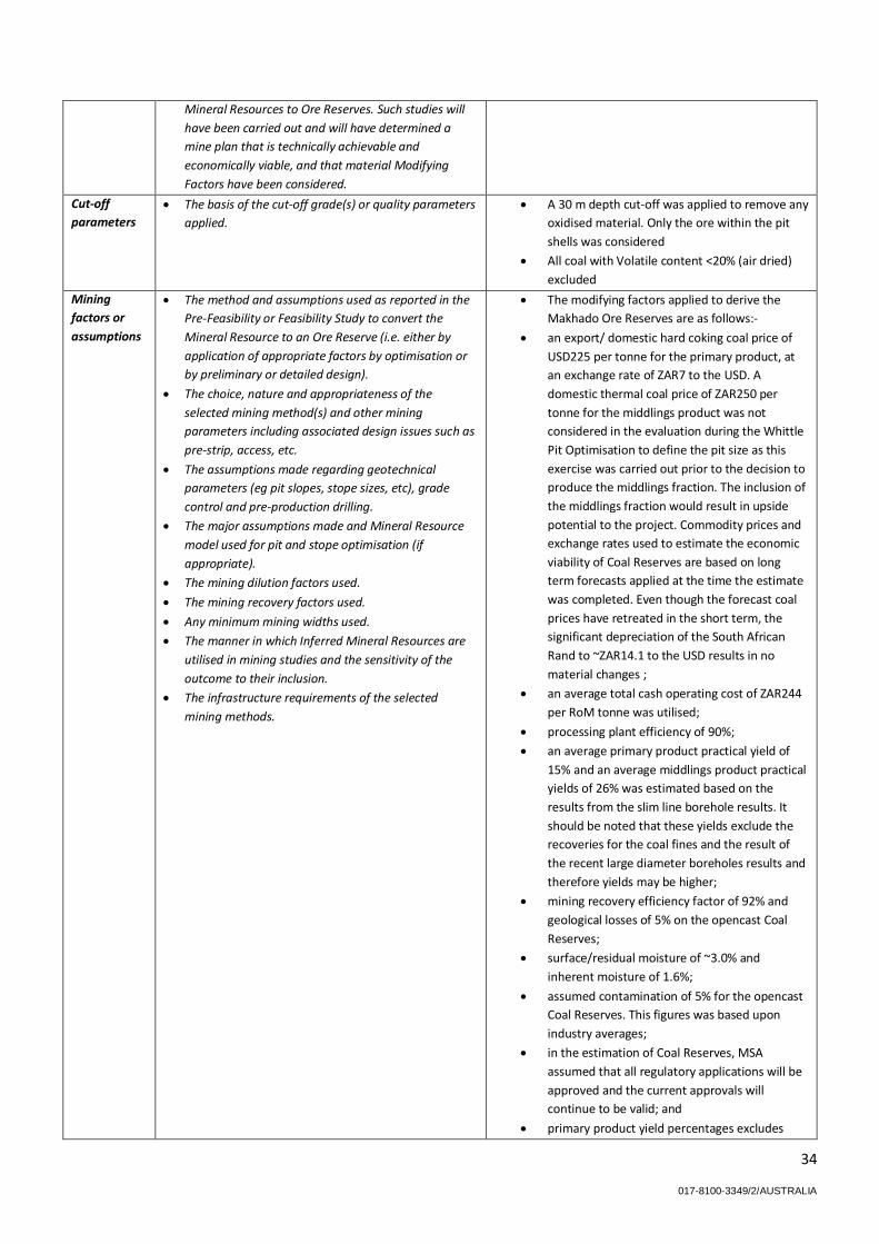
34
017-8100-3349/2/AUSTRALIA
Mineral Resources to Ore Reserves. Such studies will
have been carried out and will have determined a
mine plan that is technically achievable and
economically viable, and that material Modifying
Factors have been considered.
Cut-off
parameters
The basis of the cut-off grade(s) or quality parameters
applied.
A 30 m depth cut-off was applied to remove any
oxidised material. Only the ore within the pit
shells was considered
All coal with Volatile content <20% (air dried)
excluded
Mining
factors or
assumptions
The method and assumptions used as reported in the
Pre-Feasibility or Feasibility Study to convert the
Mineral Resource to an Ore Reserve (i.e. either by
application of appropriate factors by optimisation or
by preliminary or detailed design).
The choice, nature and appropriateness of the
selected mining method(s) and other mining
parameters including associated design issues such as
pre-strip, access, etc.
The assumptions made regarding geotechnical
parameters (eg pit slopes, stope sizes, etc), grade
control and pre-production drilling.
The major assumptions made and Mineral Resource
model used for pit and stope optimisation (if
appropriate).
The mining dilution factors used.
The mining recovery factors used.
Any minimum mining widths used.
The manner in which Inferred Mineral Resources are
utilised in mining studies and the sensitivity of the
outcome to their inclusion.
The infrastructure requirements of the selected
mining methods.
The modifying factors applied to derive the
Makhado Ore Reserves are as follows:-
an export/ domestic hard coking coal price of
USD225 per tonne for the primary product, at
an exchange rate of ZAR7 to the USD. A
domestic thermal coal price of ZAR250 per
tonne for the middlings product was not
considered in the evaluation during the Whittle
Pit Optimisation to define the pit size as this
exercise was carried out prior to the decision to
produce the middlings fraction. The inclusion of
the middlings fraction would result in upside
potential to the project. Commodity prices and
exchange rates used to estimate the economic
viability of Coal Reserves are based on long
term forecasts applied at the time the estimate
was completed. Even though the forecast coal
prices have retreated in the short term, the
significant depreciation of the South African
Rand to ~ZAR14.1 to the USD results in no
material changes ;
an average total cash operating cost of ZAR244
per RoM tonne was utilised;
processing plant efficiency of 90%;
an average primary product practical yield of
15% and an average middlings product practical
yields of 26% was estimated based on the
results from the slim line borehole results. It
should be noted that these yields exclude the
recoveries for the coal fines and the result of
the recent large diameter boreholes results and
therefore yields may be higher;
mining recovery efficiency factor of 92% and
geological losses of 5% on the opencast Coal
Reserves;
surface/residual moisture of ~3.0% and
inherent moisture of 1.6%;
assumed contamination of 5% for the opencast
Coal Reserves. This figures was based upon
industry averages;
in the estimation of Coal Reserves, MSA
assumed that all regulatory applications will be
approved and the current approvals will
continue to be valid; and
primary product yield percentages excludes

35
017-8100-3349/2/AUSTRALIA
fines recovery.
Metallurgical
factors or
assumptions
The metallurgical process proposed and the
appropriateness of that process to the style of
mineralisation.
Whether the metallurgical process is well-tested
technology or novel in nature.
The nature, amount and representativeness of
metallurgical test work undertaken, the nature of the
metallurgical domaining applied and the
corresponding metallurgical recovery factors applied.
Any assumptions or allowances made for deleterious
elements.
The existence of any bulk sample or pilot scale test
work and the degree to which such samples are
considered representative of the orebody as a whole.
For minerals that are defined by a specification, has
the ore reserve estimation been based on the
appropriate mineralogy to meet the specifications?
DRA Mineral Projects (Pty) Ltd (DRA) was
contracted by CoAL to carry out the portion of
the feasibility study covering the coal handling
and processing plant (CHPP) for the Makhado
Coal Project.
The plant needs to be efficient in terms of
energy and water usage and should apply
technology that is proven in the coal processing
industry.
A bulk sample was mined and sent to Exxaro’s
Tshikondeni site for processing.
A 60 t sample was split from the bulk sample
and sent to the Exxaro Pilot Plant for further
test work.
The bulk sample fractional yield indicates a
similar trend from low to high yield for the coal
from coarser to the finer fractions respectively.
The bulk sample theoretical yield is however
significantly lower than the yield from the large
core borehole sample.
Some of the reasons for the lower yield, but not
limited to, are:
o Over blasting of the coal seams
resulting in high level of
contamination;
o Further contamination due to large
equipment loading of roof and floor
material in a small box cut area.
Pilot plant DMS test work on the bulk sample
resulted in an 11.4% ash product at a yield
around 10%. The test work was based on a
single stage wash at a medium RD of 1.34, it is
expected that a product with ash content closer
to 10% ash can be achieved with a two stage
DMS circuit comprising of high gravity (HG)
wash followed by a low gravity (LG) wash. The
HG wash in this configuration plays a destoning
role prior to final separation in the LG washing
stage.
Environmen-
tal
The status of studies of potential environmental
impacts of the mining and processing operation.
Details of waste rock characterisation and the
consideration of potential sites, status of design
options considered and, where applicable, the status
of approvals for process residue storage and waste
dumps should be reported.
The Makhado Project footprint is in an
environmentally and ecologically sensitive area.
Thus the necessary diligence was exercised
when consideration was given to the location,
placement and orientation of the mine
infrastructure area facilities.
Energy efficiency is considered when
orientating and designing buildings. Office
buildings are where possible, north-facing.
The Integrated Water Use License has been
granted by the Department of Water and
Sanitation.
Infrastructure The existence of appropriate infrastructure:
availability of land for plant development, power,
water, transportation (particularly for bulk
CoAL will obtain road access to site using the
existing gravel Nzhelele Road off the N1.
Road access to the mine will be directly from

36
017-8100-3349/2/AUSTRALIA
commodities), labour, accommodation; or the ease
with which the infrastructure can be provided, or
accessed.
the Nzhelele Road at an “at grade” intersection,
which will provide access to both the mining
area as well as to the proposed rail loadout
station.
Costs The derivation of, or assumptions made, regarding
projected capital costs in the study.
The methodology used to estimate operating costs.
Allowances made for the content of deleterious
elements.
The derivation of assumptions made of metal or
commodity price(s), for the principal minerals and co-
products.
The source of exchange rates used in the study.
Derivation of transportation charges.
The basis for forecasting or source of treatment and
refining charges, penalties for failure to meet
specification, etc.
The allowances made for royalties payable, both
Government and private.
The capital cost estimate was compiled by an
independent quantity surveying company (Venn
& Milford Inc.) and to present them in
accordance with the developed Work
Breakdown Structure (WBS). The costs were
estimated from Bills of Quantities (BoQ) derived
from specialist consultants’ drawings,
quotations received for equipment, and
extracts from estimates of recently completed
projects.
The on-mine operating-cost estimates for the
Makhado Project are defined as costs including
mining, processing, maintenance, logistics,
overheads and indirect costs. The operating
cost is based on the Feasibility Study
recommendation that mining will be
“contractor operated” and the plant will be
“owner operated”.
Revenue
factors
The derivation of, or assumptions made regarding
revenue factors including head grade, metal or
commodity price(s) exchange rates, transportation
and treatment charges, penalties, net smelter returns,
etc.
the derivation of assumptions made of metal or
commodity price(s), for the principal metals, minerals
and co-products.
Forecast sales prices and exchange rates are
based on the average of consensus market
forecasts.
Over the last 6 months, the rand has averaged
R13:00 to the USD but the general consensus of
investment analysts is that the Rand will
continue its downward trend and Rand
Merchant Bank is forecasting ZAR15.42 to the
USD in 12 months’ time. Another commentator
has forecast a rate of R15.90 to the USD in the
next 12 months.
Market
assessment
The demand, supply and stock situation for the
particular commodity, consumption trends and factors
likely to affect supply and demand into the future.
A customer and competitor analysis along with the
identification of likely market windows for the
product.
Price and volume forecasts and the basis for these
forecasts.
For industrial minerals the customer specification,
testing and acceptance requirements prior to a supply
contract.
Established external forecast analysts have
provided guidance to assess the long term
market and sale of coking and thermal coal.
No sales or off-take agreement are currently in
place.
Economic The inputs to the economic analysis to produce the
net present value (NPV) in the study, the source and
confidence of these economic inputs including
estimated inflation, discount rate, etc.
NPV ranges and sensitivity to variations in the
significant assumptions and inputs.
The valuation must comply with the AIM rules
of using a real discount rate of 10%. The NPVs
will be in real terms determined after the
inflate/deflate methodology has been
implemented. With a South African inflation
rate estimated at 6% per annum, a 10%
discount rate equates to a 16.71% nominal
discount rate.
Social The status of agreements with key stakeholders and
matters leading to social license to operate.
CoAL has informed MSA of land claims on the
farms Fripp 645 MS, Tanga 648 MS, Lukin 643
MS and Salaita 188 MS. The land claims on the

37
017-8100-3349/2/AUSTRALIA
various properties have been gazetted by the
Department of Rural Development and Land
Reform (DRDLR). CoAL recognises land
claimants as key stakeholders, and the
company’s engagement is governed by the
company’s stakeholder engagement strategy
that ensures regular, meaningful and
transparent engagement. CoAL recognises the
legislative framework of the land claims process
and will work within that framework.
Other To the extent relevant, the impact of the following on
the project and/or on the estimation and classification
of the Ore Reserves:
Any identified material naturally occurring risks.
The status of material legal agreements and
marketing arrangements.
The status of governmental agreements and
approvals critical to the viability of the project, such as
mineral tenement status, and government and
statutory approvals. There must be reasonable
grounds to expect that all necessary Government
approvals will be received within the timeframes
anticipated in the Pre-Feasibility or Feasibility study.
Highlight and discuss the materiality of any
unresolved matter that is dependent on a third party
on which extraction of the reserve is contingent.
The DMR accepted an NOMR application by
CoAL on the farms Mutamba 668MS, Windhoek
649MS, Daru 848MS, Tanga 849MS, Fripp
645MS, Lukin 643MS and Salaita 188MT on the
25th February 2011, and granted in 15 May
2015. The application covers a Mining Right
Area of 7,634 ha. This right will supersede the
current NOPRs and the required renewals
thereof.
The Integrated Water Use License has been
granted by the Department of Water and
Sanitation.
Classification The basis for the classification of the Ore Reserves into
varying confidence categories.
Whether the result appropriately reflects the
Competent Person’s view of the deposit.
The proportion of Probable Ore Reserves that have
been derived from Measured Mineral Resources (if
any).
In the case of Makhado, the Competent Person
has classified all the Makhado Reserves into the
Probable category, although 85% of the
Resources from which they are derived, are
classified as Measured Resources. The reason
for this classification relates to the uncertainty
around the yields. The yields estimated across
the orebody model have been estimated based
on slim-line drilling only and using crushing.
Recent bulk sampling results at isolated
locations across the deposit have suggested
that higher yields may be obtained using this
different drilling methods and crushing
methods, and indeed when the deposit is mined
and processed. There is currently insufficient
data currently available to accurately prove
statistically or geostatistically that the yield
across the deposit would be higher than
currently estimated and therefore the
classification of Probable Reserves have been
decided.
Audits or
reviews
The results of any audits or reviews of Ore Reserve
estimates.
The Makhado Project Coal Resource was
previously reviewed by Venmyn Deloitte (Pty)
Ltd in 2013 and the MSA Group in 2015.
No adverse finding were recorded.
Discussion of
relative
accuracy/
confidence
Where appropriate a statement of the relative
accuracy and confidence level in the Ore Reserve
estimate using an approach or procedure deemed
appropriate by the Competent Person. For example,
The Ore Reserves estimates have been completed to
a minimum of feasibility level of confidence.
The results were benchmarked against other local
operators and independently verified by Venmyn-

38
017-8100-3349/2/AUSTRALIA
the application of statistical or geostatistical
procedures to quantify the relative accuracy of the
reserve within stated confidence limits, or, if such an
approach is not deemed appropriate, a qualitative
discussion of the factors which could affect the
relative accuracy and confidence of the estimate.
The statement should specify whether it relates to
global or local estimates, and, if local, state the
relevant tonnages, which should be relevant to
technical and economic evaluation. Documentation
should include assumptions made and the procedures
used.
Accuracy and confidence discussions should extend to
specific discussions of any applied Modifying Factors
that may have a material impact on Ore Reserve
viability, or for which there are remaining areas of
uncertainty at the current study stage.
It is recognised that this may not be possible or
appropriate in all circumstances. These statements of
relative accuracy and confidence of the estimate
should be compared with production data, where
available.
Deloitte
The accuracy of the estimates will be subject to
regular reconciliation and ongoing monitoring.

017-8100-3349/2/AUSTRALIA
APPENDIX 2
JORC 2012, Table 1 Report for Vele Colliery
Section 1 Sampling Techniques and Data
(Criteria in this section apply to all succeeding sections.)
Criteria JORC Code explanation Commentary
Sampling
techniques
Nature and quality of sampling (eg cut channels, random chips, or specific
specialised industry standard measurement tools appropriate to the minerals
under investigation, such as down hole gamma sondes, or handheld XRF
instruments, etc). These examples should not be taken as limiting the broad
meaning of sampling.
Include reference to measures taken to ensure sample representivity and the
appropriate calibration of any measurement tools or systems used.
Aspects of the determination of mineralisation that are Material to the Public
Report.
In cases where ‘industry standard’ work has been done this would be relatively
simple (eg ‘reverse circulation drilling was used to obtain 1 m samples from
which 3 kg was pulverised to produce a 30 g charge for fire assay’). In other
cases more explanation may be required, such as where there is coarse gold
that has inherent sampling problems. Unusual commodities or mineralisation
types (eg submarine nodules) may warrant disclosure of detailed information.
All samples from the deposit was taken through diamond core drilling.
All cored boreholes and open holes were has downhole geophysical data. All
sondes and equipment used for downhole geophysics was calibrated at regular
intervals.
All samples were taken across the coal seam and the sample sizes depended on
the ply thickness
To ensure that sampling bias was minimised the whole core was sampled as per
SANS 10320:2004
Drilling
techniques
Drill type (eg core, reverse circulation, open-hole hammer, rotary air blast,
auger, Bangka, sonic, etc) and details (eg core diameter, triple or standard tube,
depth of diamond tails, face-sampling bit or other type, whether core is
oriented and if so, by what method, etc).
The project was evaluated through diamond core drill holes (slim and large
diameter) as well as percussion drill holes. Details of the drilling is presented in
the report
Drill sample
recovery
Method of recording and assessing core and chip sample recoveries and results
assessed.
Measures taken to maximise sample recovery and ensure representative
nature of the samples.
Sample recovery through diamond drilling has to be more than 95% for coal
intersections. This is closely monitored by field geologists. If the recovery is
not obtained then a re-drill of the drill hole is required.
As the whole core is sampled the bias associated with sampling is minimised

40
017-8100-3349/2/AUSTRALIA
Whether a relationship exists between sample recovery and grade and whether
sample bias may have occurred due to preferential loss/gain of fine/coarse
material.
Logging Whether core and chip samples have been geologically and geotechnically
logged to a level of detail to support appropriate Mineral Resource estimation,
mining studies and metallurgical studies.
Whether logging is qualitative or quantitative in nature. Core (or costean,
channel, etc) photography.
The total length and percentage of the relevant intersections logged.
The core is logged in detail according to specified procedures drafted by MSA
and adopted by CoAl. The logging is of sufficient detail to support Coal Resource
Estimation, mining studies and processing studies.
The logging is quantitative and qualitative and the core has been photographed
since CoAl has been involved in the project
Sub-sampling
techniques and
sample
preparation
If core, whether cut or sawn and whether quarter, half or all core taken.
If non-core, whether riffled, tube sampled, rotary split, etc and whether
sampled wet or dry.
For all sample types, the nature, quality and appropriateness of the sample
preparation technique.
Quality control procedures adopted for all sub-sampling stages to maximise
representivity of samples.
Measures taken to ensure that the sampling is representative of the in situ
material collected, including for instance results for field duplicate/second-half
sampling.
Whether sample sizes are appropriate to the grain size of the material being
sampled.
All the core that intersected coal seams were sampled
All sample preparation techniques are done in accordance to internationally
accepted standards
Whole core is sampled and samplers have to ensure that all material, especially
fines, are collected with the core sample
The sample sizes are adequate for the grain sizes of the material being sampled
Quality of assay
data and
laboratory tests
The nature, quality and appropriateness of the assaying and laboratory
procedures used and whether the technique is considered partial or total.
For geophysical tools, spectrometers, handheld XRF instruments, etc, the
parameters used in determining the analysis including instrument make and
model, reading times, calibrations factors applied and their derivation, etc.
Nature of quality control procedures adopted (eg standards, blanks, duplicates,
external laboratory checks) and whether acceptable levels of accuracy (ie lack
of bias) and precision have been established.
All laboratories used are accredited with SANAS and all assay techniques are
done in accordance to internationally accepted standards
Internal laboratory control measures are in place. Duplicate samples are
analysed and if the difference between two duplicates are outside of acceptable
ranges. Analyses will be redone and instruments calibrated.
A reference sample is entered with each bath on each shift to verify analyses
Verification of
sampling and
assaying
The verification of significant intersections by either independent or alternative
company personnel.
The use of twinned holes.
Documentation of primary data, data entry procedures, data verification, data
storage (physical and electronic) protocols.
Discuss any adjustment to assay data.
Result can be verified against wire-line logs. The dataset has been audited on
two occasions by independent third parties
No twin drill holes have been used because with seam correlation typical
analysis for each seam intersection can be assessed
All data is stored on a SableTM database with a back-up stored at Coal head
offices
No adjustments to assay values have been made

41
017-8100-3349/2/AUSTRALIA
Location of data
points
Accuracy and quality of surveys used to locate drill holes (collar and down-hole
surveys), trenches, mine workings and other locations used in Mineral Resource
estimation.
Specification of the grid system used.
Quality and adequacy of topographic control.
All drill holes have been surveyed after they were completed from a fixed point
base station by registered surveyors. The method employed is adequate for
Coal Resource Estimations
The survey system is WGS Hartebeeshoek 84 LO29
The topography has been created through a LIDAR survey with a high spatial
accuracy
Data spacing and
distribution
Data spacing for reporting of Exploration Results.
Whether the data spacing and distribution is sufficient to establish the degree
of geological and grade continuity appropriate for the Mineral Resource and
Ore Reserve estimation procedure(s) and classifications applied.
Whether sample compositing has been applied.
Data points are spaced between 200m and 500m
Correlation cross drilling indicates that the spacing between data points are
sufficient knowledge regarding structural and quality continuity to be used in
Coal Resource and Coal Reserve estimations with a low level of risk
If more than one sample was taken across a composite coal seam the samples
were composited in to one sample representing the coal seam thickness
Orientation of
data in relation
to geological
structure
Whether the orientation of sampling achieves unbiased sampling of possible
structures and the extent to which this is known, considering the deposit type.
If the relationship between the drilling orientation and the orientation of key
mineralised structures is considered to have introduced a sampling bias, this
should be assessed and reported if material.
The coal seams have a very low dip angle of 2 degrees. Therefore horizontal
drilling achieves a unbiased sample intersection
The drilling orientation is parallel to faults and dolerite dykes. These structures
are normally identified through geophysical surveys and not exploration and
resource drilling
Sample security The measures taken to ensure sample security. Samples were locked up on site and transported by CoAL personnel to assaying
laboratories
Audits or reviews The results of any audits or reviews of sampling techniques and data. Previous reviews by the Mineral Corporation and Venmyn Rand did not uncover
any issues with the methodologies applied.

42
017-8100-3349/2/AUSTRALIA
Section 2 Reporting of Exploration Results
(Criteria listed in the preceding section also apply to this section.)
Criteria JORC Code explanation Commentary
Mineral
tenement and
land tenure
status
Type, reference name/number, location and ownership including agreements
or material issues with third parties such as joint ventures, partnerships,
overriding royalties, native title interests, historical sites, wilderness or national
park and environmental settings.
The security of the tenure held at the time of reporting along with any known
impediments to obtaining a licence to operate in the area.
Refer to section for Details on Tenure
Currently there is no impediments of which VBKom is aware that is a risk to the
security of tenure for the Vele Colliery
Exploration done
by other parties
Acknowledgment and appraisal of exploration by other parties. Previous exploration activities completed by Southern Sphere is adjudicated as
of sufficient quality to include in to the Coal Resource estimation
Geology Deposit type, geological setting and style of mineralisation. The deposit type and the controls on the deposit is very well understood
Drill hole
Information
A summary of all information material to the understanding of the exploration
results including a tabulation of the following information for all Material drill
holes:
easting and northing of the drill hole collar
elevation or RL (Reduced Level – elevation above sea level in metres) of the drill
hole collar
dip and azimuth of the hole
down hole length and interception depth
hole length.
If the exclusion of this information is justified on the basis that the information
is not Material and this exclusion does not detract from the understanding of
the report, the Competent Person should clearly explain why this is the case.
Refer to appendix 3 for the full CPR made available on the CoAL of Africa
website for details regarding the drill holes included in the geological modelling
and Coal Resource estimation.
The drill holes excluded from the model and estimation will not have a material
effect on the model and estimation
Data
aggregation
methods
In reporting Exploration Results, weighting averaging techniques, maximum
and/or minimum grade truncations (eg cutting of high grades) and cut-off
grades are usually Material and should be stated.
Where aggregate intercepts incorporate short lengths of high grade results and
longer lengths of low grade results, the procedure used for such aggregation
should be stated and some typical examples of such aggregations should be
shown in detail.
The assumptions used for any reporting of metal equivalent values should be
clearly stated.
Data is aggregated on tonnes
No other data manipulation is conducted
All sample lengths were controlled by seam thickness and aggregation occurred
based on length and mass
No other economic mineral occurs with the coal deposit so no equivalent grades
were reported
Relationship
between
mineralisation
These relationships are particularly important in the reporting of Exploration
Results.
If the geometry of the mineralisation with respect to the drill hole angle is
known, its nature should be reported.
The relationship with the seam geometry is well understood. The seams dips at
2 degrees and it can be accepted for the purpose of modelling that the drill hole
intercept the seams at 90 degrees.

43
017-8100-3349/2/AUSTRALIA
widths and
intercept lengths
If it is not known and only the down hole lengths are reported, there should be
a clear statement to this effect (eg ‘down hole length, true width not known’).
Diagrams Appropriate maps and sections (with scales) and tabulations of intercepts
should be included for any significant discovery being reported These should
include, but not be limited to a plan view of drill hole collar locations and
appropriate sectional views.
Appropriate maps and diagrams are presented that included drill hole collar
positions
Balanced
reporting
Where comprehensive reporting of all Exploration Results is not practicable,
representative reporting of both low and high grades and/or widths should be
practiced to avoid misleading reporting of Exploration Results.
The full CPR report is comprehensive with regards to reporting seam
thicknesses and qualities. All material and meaning full data is reported on in
the report. The full CPR is available on the CoAL website.
Other
substantive
exploration data
Other exploration data, if meaningful and material, should be reported
including (but not limited to): geological observations; geophysical survey
results; geochemical survey results; bulk samples – size and method of
treatment; metallurgical test results; bulk density, groundwater, geotechnical
and rock characteristics; potential deleterious or contaminating substances.
Further work The nature and scale of planned further work (eg tests for lateral extensions or
depth extensions or large-scale step-out drilling).
Diagrams clearly highlighting the areas of possible extensions, including the
main geological interpretations and future drilling areas, provided this
information is not commercially sensitive.
The area is constrained to the north by and international border between South
Africa and Zimbabwe. The deposit out crops to the south and east. A national
park border to the west.

44
017-8100-3349/2/AUSTRALIA
Section 3 Estimation and Reporting of Mineral Resources
(Criteria listed in section 1, and where relevant in section 2, also apply to this section.)
Criteria JORC Code explanation Commentary
Database
integrity
Measures taken to ensure that data has not been corrupted by, for example,
transcription or keying errors, between its initial collection and its use for
Mineral Resource estimation purposes.
Data validation procedures used.
Hand written data was captured into electronic format by CoAL personnel.
Random checks were done to ensure data was correctly captured. The process
has also been submitted for auditing by independent third parties
Data was validated by CoAL’s Chief geologist.
Site visits Comment on any site visits undertaken by the Competent Person and the
outcome of those visits.
If no site visits have been undertaken indicate why this is the case.
The site was visited by Mr B.W. Botha on 26 November 2015 to validate the
asset mentioned in the report
Geological
interpretation
Confidence in (or conversely, the uncertainty of) the geological interpretation
of the mineral deposit.
Nature of the data used and of any assumptions made.
The effect, if any, of alternative interpretations on Mineral Resource
estimation.
The use of geology in guiding and controlling Mineral Resource estimation.
The factors affecting continuity both of grade and geology.
There is a high confidence in the geological model as stratified coal deposits are
very well understood deposits.
Only data gathered from drill holes (diamond and percussion) was used to
construct the geological model
No other geological interpretation is feasible for the deposit type and there will
have no bearing on the Mineral Resource Estimation.
The Coal Resource estimation is controlled by the geology i.e. constrained
within
Dimensions The extent and variability of the Mineral Resource expressed as length (along
strike or otherwise), plan width, and depth below surface to the upper and
lower limits of the Mineral Resource.
The dimensions of the deposit is documented and illustrated with the aid of
diagrams in the text
Estimation and
modelling
techniques
The nature and appropriateness of the estimation technique(s) applied and key
assumptions, including treatment of extreme grade values, domaining,
interpolation parameters and maximum distance of extrapolation from data
points. If a computer assisted estimation method was chosen include a
description of computer software and parameters used.
The availability of check estimates, previous estimates and/or mine production
records and whether the Mineral Resource estimate takes appropriate account
of such data.
The assumptions made regarding recovery of by-products.
Estimation of deleterious elements or other non-grade variables of economic
significance (eg sulphur for acid mine drainage characterisation).
In the case of block model interpolation, the block size in relation to the average
sample spacing and the search employed.
Any assumptions behind modelling of selective mining units.
Any assumptions about correlation between variables.
The Coal Resource estimation is done by the gridding algorithm that is part of
the MINEXtm, which is a well-established method for estimation in the coal
industry. No domaining was done for the quality estimate, but was applied with
the seam thickness estimation based on faults and dykes
The Mineral Resource estimate was previously done by the Mineral Corporation
and Venmyn Rand and was reviewed by VBKom. The mine extracted 144kt of
coal and this was considered in the estimation of the Coal Resources.
There is no by-products present in the coal deposit
Sulphur and phosphorous was analysed for and is estimated within the
geological model. Sulphur is reported in the Coal Resource Statement, but
phosphorous is excluded due to the low concentrations present.
The model is based on a grid and not blocks
All units i.e. seams are modelled based on drill hole seam intersections and
down-hole geophysical survey
There is a correlation between ash and CV in the deposit and is used as
verification of estimated results

45
017-8100-3349/2/AUSTRALIA
Description of how the geological interpretation was used to control the
resource estimates.
Discussion of basis for using or not using grade cutting or capping.
The process of validation, the checking process used, the comparison of model
data to drill hole data, and use of reconciliation data if available.
All estimations were constrained within the defined coal seams
Coal is defined as material below 60% ash content. This is the only form of
capping applied
The data is validated through cross sections and various coal quality plots
Moisture Whether the tonnages are estimated on a dry basis or with natural moisture,
and the method of determination of the moisture content.
Tonnages are reported as air dried inclusive of the inherent moisture
Cut-off
parameters
The basis of the adopted cut-off grade(s) or quality parameters applied. Volatile less than 18 (dried ash free) was excluded to ensure no devolatilised
coal was included in the geological model
Mining factors or
assumptions
Assumptions made regarding possible mining methods, minimum mining
dimensions and internal (or, if applicable, external) mining dilution. It is always
necessary as part of the process of determining reasonable prospects for
eventual economic extraction to consider potential mining methods, but the
assumptions made regarding mining methods and parameters when estimating
Mineral Resources may not always be rigorous. Where this is the case, this
should be reported with an explanation of the basis of the mining assumptions
made.
The project has been commissioned, but is now under care and maintenance.
Studies have been done to convert the Coal Resources to Coal Reserves and the
conclusion was that most of the resource is economically extractable
Metallurgical
factors or
assumptions
The basis for assumptions or predictions regarding metallurgical amenability. It
is always necessary as part of the process of determining reasonable prospects
for eventual economic extraction to consider potential metallurgical methods,
but the assumptions regarding metallurgical treatment processes and
parameters made when reporting Mineral Resources may not always be
rigorous. Where this is the case, this should be reported with an explanation of
the basis of the metallurgical assumptions made.
The project has been commissioned, but is now under care and maintenance.
Studies have been done to convert the Coal Resources to Coal Reserves and the
conclusion was that most of the resource is beneficiatable to a saleable product
either in the domestic market or international market
Environmental
factors or
assumptions
Assumptions made regarding possible waste and process residue disposal
options. It is always necessary as part of the process of determining reasonable
prospects for eventual economic extraction to consider the potential
environmental impacts of the mining and processing operation. While at this
stage the determination of potential environmental impacts, particularly for a
greenfields project, may not always be well advanced, the status of early
consideration of these potential environmental impacts should be reported.
Where these aspects have not been considered this should be reported with an
explanation of the environmental assumptions made.
The area under the current mining Right has an approved Environmental
Management Programme based on an Environmental Impact Assessment
Bulk density Whether assumed or determined. If assumed, the basis for the assumptions. If
determined, the method used, whether wet or dry, the frequency of the
measurements, the nature, size and representativeness of the samples.
The bulk density was calculated on every sample submitted to the laboratory.
There is an internationally accepted standard to determine the bulk density of
coal
The Bulk density method is based on the Archimedes process that accounts for
voids

46
017-8100-3349/2/AUSTRALIA
The bulk density for bulk material must have been measured by methods that
adequately account for void spaces (vugs, porosity, etc), moisture and
differences between rock and alteration zones within the deposit.
Discuss assumptions for bulk density estimates used in the evaluation process
of the different materials.
The density is estimated in the geological model with the same parameters as
for the qualities and structural information
Classification The basis for the classification of the Mineral Resources into varying confidence
categories.
Whether appropriate account has been taken of all relevant factors (ie relative
confidence in tonnage/grade estimations, reliability of input data, confidence
in continuity of geology and metal values, quality, quantity and distribution of
the data).
Whether the result appropriately reflects the Competent Person’s view of the
deposit.
The classification is based on the distance between data point as determined
by the correlation cross that was drilled. Additional information considered was
confidence in collar position, topographic surface, quality of assays
The result of the classification appropriately reflects the Competent Person’s
view of the deposit
Audits or reviews The results of any audits or reviews of Mineral Resource estimates. The process of Coal Resource Estimation has been audited by Mineral
Corporation (completed 2010) and Venmyn Rand (completed in 2012). Both
these audits did not found any material issues with the estimations, estimation
methodology and classification of the Coal Resources
Discussion of
relative
accuracy/
confidence
Where appropriate a statement of the relative accuracy and confidence level in
the Mineral Resource estimate using an approach or procedure deemed
appropriate by the Competent Person. For example, the application of
statistical or geostatistical procedures to quantify the relative accuracy of the
resource within stated confidence limits, or, if such an approach is not deemed
appropriate, a qualitative discussion of the factors that could affect the relative
accuracy and confidence of the estimate.
The statement should specify whether it relates to global or local estimates,
and, if local, state the relevant tonnages, which should be relevant to technical
and economic evaluation. Documentation should include assumptions made
and the procedures used.
These statements of relative accuracy and confidence of the estimate should
be compared with production data, where available.
The is a high confidence in the Coal Resource estimate as the appropriate
methods were applied to define and determine the Coal Resources, The criteria
used to classify the Coal Resources into different confidence categories is also
deemed appropriate by the Competent Person
The estimate refers to global estimates
The current production data is insufficient to comment on the accuracy of the
quality model, but indicates there is a high confidence in the structural
interpretation
There is currently not sufficient production data to compare with estimated
values.

47
017-8100-3349/2/AUSTRALIA
Section 4 Estimation and Reporting of Ore Reserves
(Criteria listed in section 1, and where relevant in sections 2 and 3, also apply to this section.)
Criteria JORC Code explanation Commentary
Coal Resource
estimate for
conversion to
Ore Reserves
Description of the Coal Resource estimate used as a basis for the conversion to
an Ore Reserve.
Clear statement as to whether the Coal Resources are reported additional to,
or inclusive of, the Ore Reserves.
Coal Resource Statement are MTIS resource.
Coal Resources are reported inclusive of Coal Reserves
Site visits Comment on any site visits undertaken by the Competent Person and the
outcome of those visits.
If no site visits have been undertaken indicate why this is the case.
Mr’s BW Botha and B Steyn undertook a site visit on 26 November 2015.
Assets of the Vele Colliery were verified
Study status The type and level of study undertaken to enable Coal Resources to be
converted to Ore Reserves.
The Code requires that a study to at least Pre-Feasibility Study level has been
undertaken to convert Coal Resources to Ore Reserves. Such studies will have
been carried out and will have determined a mine plan that is technically
achievable and economically viable, and that material Modifying Factors have
been considered.
Vele Colliery has completed various studies on the mining and processing plant
of sufficient levels (comparable with pre-feasibility studies) to justify the
conversion from Coal Resources to Coal Reserves.
Cut-off
parameters
The basis of the cut-off grade(s) or quality parameters applied. Most of the cut-off grades were applied to the Coal Resource in the calculation
MTIS resources. The only other mining cut-off applied is that the Bottom Lower
Seam has to be more than 60m underground to be extracted. This is required
to extract the Coal Reserves safely.
Mining factors or
assumptions
The method and assumptions used as reported in the Pre-Feasibility or
Feasibility Study to convert the Coal Resource to an Ore Reserve (i.e. either by
application of appropriate factors by optimisation or by preliminary or detailed
design).
The choice, nature and appropriateness of the selected mining method(s) and
other mining parameters including associated design issues such as pre-strip,
access, etc.
The assumptions made regarding geotechnical parameters (eg pit slopes, stope
sizes, etc), grade control and pre-production drilling.
The major assumptions made and Coal Resource model used for pit and stope
optimisation (if appropriate).
The mining dilution factors used.
The mining recovery factors used.
Any minimum mining widths used.
The manner in which Inferred Coal Resources are utilised in mining studies and
the sensitivity of the outcome to their inclusion.
For the PMP design localised optimisation was achieved through mine lay-out
and scheduling of the col to the plant.
The additional RoM was based on opencastable reserves and underground
designs based on the Salamon formula.
The mining methods chosen is well known and applicable to this type of deposit
Geotechnical studies was used to define the opencast pit geometry. The open
pit is also regularly inspected to ensure compliance to the design criteria
The Salamon formula was used for the underground design
An additional 5% geological loss was applied
Mining recovery of 92% applied
Minimum seam thickness for the opencast is 0.5m and 1.4m for the
underground sections
Inferred Resource are not present in the PMP on which the business case is
build. Inferred Resources occur only much later in the LoM, and can be
addressed with infill drilling

48
017-8100-3349/2/AUSTRALIA
The infrastructure requirements of the selected mining methods. All infrastructure for the PMP is already been built when the mine was in
operation
Grade control drilling will 50m x 100m and has been planned for in the mining
schedule
Metallurgical
factors or
assumptions
The metallurgical process proposed and the appropriateness of that process to
the style of mineralisation.
Whether the metallurgical process is well-tested technology or novel in nature.
The nature, amount and representativeness of metallurgical test work
undertaken, the nature of the metallurgical domaining applied and the
corresponding metallurgical recovery factors applied.
Any assumptions or allowances made for deleterious elements.
The existence of any bulk sample or pilot scale test work and the degree to
which such samples are considered representative of the orebody as a whole.
For minerals that are defined by a specification, has the ore reserve estimation
been based on the appropriate mineralogy to meet the specifications?
The current process plant and the proposed modification to the plant is well
known technology in the coal mining industry
A total of 39 LDD holes have been drilled over the Central – and Northern Pit to
provide a high confidence in the yield for the PMP mining operation
There are no deleterious elements occurring within the coal deposit with
significant amount to warrant allowances for such elements
The metallurgical test work is based on drop shatter and wet tumble test. The
yield distribution per sixe fraction was used to optimise the product mix and
the coal preparation plant. The samples tested is representative for the PMP
project.
The Coal Reserves are based saleable product
Environmental The status of studies of potential environmental impacts of the mining and
processing operation. Details of waste rock characterisation and the
consideration of potential sites, status of design options considered and, where
applicable, the status of approvals for process residue storage and waste dumps
should be reported.
Huge amount of environmental studies have been undertaken on the Vele
Colliery.
All requirement of the Department of Environmental Affairs have been met and
the mine has an approved EMP as well as an IWUL.
Infrastructure The existence of appropriate infrastructure: availability of land for plant
development, power, water, transportation (particularly for bulk commodities),
labour, accommodation; or the ease with which the infrastructure can be
provided, or accessed.
Most of the required infrastructure has already been constructed on site. The
power lines from Pontdrift is 78% completed with some servitudes still pending.
All labour will be sourced from local communities and towns and no
accommodation will be provided
Infrastructure for the underground sections will only be constructed when the
mine moves into these areas
Costs The derivation of, or assumptions made, regarding projected capital costs in the
study.
The methodology used to estimate operating costs.
Allowances made for the content of deleterious elements.
The source of exchange rates used in the study.
Derivation of transportation charges.
The basis for forecasting or source of treatment and refining charges, penalties
for failure to meet specification, etc.
The allowances made for royalties payable, both Government and private.
Capital cost are based on tendered quotations
The mine and process plant will be operated by contractors who provided
tendered quotations
There is no deleterious elements present in significant concentrations to be
considered
Exchange rates is based on the financial forecast of varies financial institutions.
The South African government requires the payment of a royalty in accordance
to the Mineral Resource and Petroleum Development Royalty Act. Provisions
for the royalties have been made based on estimated profit per year

49
017-8100-3349/2/AUSTRALIA
Revenue factors The derivation of, or assumptions made regarding revenue factors including
head grade, metal or commodity price(s) exchange rates, transportation and
treatment charges, penalties, net smelter returns, etc.
The derivation of assumptions made of metal or commodity price(s), for the
principal metals, minerals and co-products.
Product prices is based on the long term estimations of various financial
institutions
All revenue factors were considered and forms part of the Monte Carlo
simulation and the financial model
Market
assessment
The demand, supply and stock situation for the particular commodity,
consumption trends and factors likely to affect supply and demand into the
future.
A customer and competitor analysis along with the identification of likely
market windows for the product.
Price and volume forecasts and the basis for these forecasts.
For industrial minerals the customer specification, testing and acceptance
requirements prior to a supply contract.
Market assessment shows thermal coal requirements will increase in India and
South Africa. India will show the most growth in the international thermal coal
market. Eskom, the sole electricity provider in South Africa, will also require
more coal reserves as the reserves in the Mpumalanga Province is almost
depleted.
For coking coal there is a demand locally with Accertol Mital has tested the SSCC
with positive results
Economic The inputs to the economic analysis to produce the net present value (NPV) in
the study, the source and confidence of these economic inputs including
estimated inflation, discount rate, etc.
NPV ranges and sensitivity to variations in the significant assumptions and
inputs.
Monte Carlo analyses has been done with 10 000 integrations. The results of
the Monte Carlo simulation proves the project robust.
All major drivers were identified and used for the simulation
Social The status of agreements with key stakeholders and matters leading to social
licence to operate.
CoAL has endeavoured to include the local communities in the Vele project.
Vele has an approved Social and Labour Plan under the MRPDA, which is geared
to assist the local communities around the mine.
Other To the extent relevant, the impact of the following on the project and/or on the
estimation and classification of the Ore Reserves:
Any identified material naturally occurring risks.
The status of material legal agreements and marketing arrangements.
The status of governmental agreements and approvals critical to the viability of
the project, such as mineral tenement status, and government and statutory
approvals. There must be reasonable grounds to expect that all necessary
Government approvals will be received within the timeframes anticipated in
the Pre-Feasibility or Feasibility study. Highlight and discuss the materiality of
any unresolved matter that is dependent on a third party on which extraction
of the reserve is contingent.
Vele Colliery was an operating mine and most of the risk to the operation has
been addressed
Significant risk that still remain is the renewal of the Prospecting Right, the PMP
project implementation timeline, and the application for the relocation of a
water coarse
Classification The basis for the classification of the Ore Reserves into varying confidence
categories.
Whether the result appropriately reflects the Competent Person’s view of the
deposit.
The Coal Reserve are classified in to different classes based on the level of
confidence in the studies done. For the PMP, which has a detailed mine design
and mine schedule, the Coal Reserves are classified as Proven. For the rest of
the reserves the confidence in the studies are less and these reserves are
classified as Probable Reserves

50
017-8100-3349/2/AUSTRALIA
The proportion of Probable Ore Reserves that have been derived from
Measured Coal Resources (if any).
Audits or reviews The results of any audits or reviews of Ore Reserve estimates. The Coal Reserves were audited by Venmyn Rand in 2012. They found no major
issues in the Coal Reserve Statement
Discussion of
relative
accuracy/
confidence
Where appropriate a statement of the relative accuracy and confidence level in
the Ore Reserve estimate using an approach or procedure deemed appropriate
by the Competent Person. For example, the application of statistical or
geostatistical procedures to quantify the relative accuracy of the reserve within
stated confidence limits, or, if such an approach is not deemed appropriate, a
qualitative discussion of the factors which could affect the relative accuracy and
confidence of the estimate.
The statement should specify whether it relates to global or local estimates,
and, if local, state the relevant tonnages, which should be relevant to technical
and economic evaluation. Documentation should include assumptions made
and the procedures used.
Accuracy and confidence discussions should extend to specific discussions of
any applied Modifying Factors that may have a material impact on Ore Reserve
viability, or for which there are remaining areas of uncertainty at the current
study stage.
It is recognised that this may not be possible or appropriate in all circumstances.
These statements of relative accuracy and confidence of the estimate should
be compared with production data, where available.
Based on the information presented and the results of previous audits a high
level of confidence can be placed on the Coal Reserve estimation
The reserves are based on global estimates
There is not sufficient production data available to verify the Coal Reserve
estimation with actual production data

017-8100-3349/2/AUSTRALIA
APPENDIX 3
JORC 2012, Table 1 Report for the Greater Soutpansberg Project
JORC
(TABLE
1)
DESCRIPTION VOORBURG SECTION
SECTION 1: SAMPLING TECHNIQUE AND DATA
1.1 SAMPLING TECHNIQUES
i Nature and quality of sampling (e.g. cut channels, random
chips, or specific specialised industry standard
measurement tools appropriate to the mineral under
investigation, such as downhole gamma sondes, or
handheld XRF instruments, etc). These examples should not
be taken as limiting the broad meaning of sampling.
A combination of RC and Diamond drilling have been used to
obtain samples. All CoAL boreholes were drilled vertically. No
down-hole directional surveys were undertaken. Given the
relatively shallow depths involved, this is not considered a
deficiency.
ii Include reference to meaures taken to ensure sample
representivity and the appropriate calibration of any
measurement tools or systems used.
iii Aspects of the determination of mineralisation that are
Material to the Public Report. In cases where 'industry
standard' work has been done this would be relatively
simple (e.g. 'reverse circulation drilling was used to obtain
1m samples from which 3kg was pulverised to produce a
30g charge for fire assay'). In other cases more explanation
may be required, such as where there is coarse gold that
has inherent sampling problems. Unusual commodities or
mineralisation types (e.g. submarine nodules) may warrant
disclosure of detailed information.
1.2 DRILLING TECHNIQUES
i Drill type and details. Diamond and reverse circulation drilling are the primary
drilling methods. The majority of the core was drilled at PQ3
size and undertaken using triple tube techniques to prevent
core loss. A number of holes drilled at size T6 for bulk
sampling purposes.
1.3 DRILL SAMPLE RECOVERY
i Methods of recording and assessing core and chip sample
recoveries and results assessed.
The minimum acceptable core recovery is 98% in coal horizons
and 95% in non-coal sediments. Core recovery within
individual coal plies was measured with reference to the
geophysical logs and, if found to be acceptable, logging
commenced, however, core recovery is not documented. Due
to the good to excellent core recovery, there is no reason to
believe that there is bias due to either sample recovery or
loss/gain of fines.
ii Measures taken to maximise sample recovery and ensure
representative nature of the samples.
iii Whether a relationship exists between sample recovery and
grade and whether sample bias may have occurred due to
preferential loss/gain of fine/coarse material.
1.4 LOGGING
i Whether core and chip samples have been geologically and
geotechnically logged to a level of detail to support
appropriate Mineral Resource estimation, mining studies
and metallurgical studies.
Core was not split prior to logging in order to minimise the
effects of oxidation. Lithological depths were finalised only
after reconciliation with the geophysical wireline logs. Field
logs were generated using printed logging forms and are

52
017-8100-3349/2/AUSTRALIA
ii Whether logging is qualitative or quantitative in nature.
Core photography.
archived at the CoAL offices in Johannesburg. Data from
handwritten logs was transferred into MS Excel™ format and
subsequently captured into a Sable™ database.
Borehole core photography using a hand-held digital camera
was initiated in January 2009 and was sporadic until
November 2009. Since that time all core has been
photographed.
Geotechnical logging has not been undertaken.
iii The total length and percentage of the relevant
intersections logged.
1.5 SUB-SAMPLING TECHNIQUES AND SAMPLE PREPARATION
i If core: whether cut or sawn and whether quarter, half or all
cores taken.
CoAL conducted whole core sampling and sample intervals
were selected on the basis of the geophysical logs. Samples
were numbered from the base upwards and correspond to the
same stratigraphic interval in every borehole.
The laboratory performed proximate and CV analyses on the
raw samples. Full washability testwork was also conducted
from an RD = 1.35 to 1.70 in 0.05 intervals and from 1.70 to
2.00 in 0.10 intervals. The closely spaced intervals were
utilised to obtain maximum information on the yields (and
associated qualities) within the expected RD range for future
processing.
In addition to the testwork described above, specific coking
coal potential tests were undertaken including the
measurement of the FSI.
Sample chips were analysed for proximate, CV, total sulphur
and vitrinite reflectance result on the RD=1.40 fraction from
each subsection but RC drilling has the potential to lose coal in
the fine fractions and this is taken into account when utilising
the results.
ii If non-core, whether riffled, tube sampled, rotary split etc
and whether sampled wet or dry.
iii For all sample types, the nature, quality and
appropriateness of the sample preparation technique.
iv Quality control procedures adopted for all sub-sampling
stages to maximise representivity of samples.
v Measures taken to ensure that the sampling is
representative of the in situ material collected, including for
instance results for field duplicate/second-half sampling.
vi Whether sample sizes are appropriate to the grain size of
the material being sampled.
1.6 QUALITY OF ASSAY DATA AND LABORATORY TESTS
i The nature, quality and appropriateness of the assaying and
laboratory procedures used and whether the
technique is considered partial or total
The laboratories followed the ISO and SANAS standard set of
tests and methods that are used for coal analyses by South
African laboratories.
The ISO and South African National Standard (SANS) has a
standard set of tests and methods that are used for coal
analyses by South African laboratories.
No standard or duplicate samples were submitted by CoAL for
analysis and no repeat or laboratory cross checks were
requested. This is not an uncommon practice in the South
African coal industry in which reliance is often placed on the
internal quality controls of the laboratories.
Downhole geophysical surveys were conducted on all the
boreholes by a dedicated Weatherford geophysical logging
unit.
ii For geophysical tools, spectrometers, handheld XRF
instruments, etc, the parameters used in determining the
analysis including instrument make and model, reading
times, calibrations factors applied and their derivation
iii Nature of quality control procedures adopted (e.g.
standards, blanks, duplicates, external laboratory checks)
and whether acceptable levels of accuracy (i.e. lack of bias)
and precision have been established.
1.7 VERIFICATION OF SAMPLING AND ASSAYING
i The verification of significant intersections by either
independent or alternative company personnel.
For the CoAL boreholes, the field geologists were responsible
for the selection of seam intervals under the supervision of the
responsible geologist, Mr. C. Mafiri (Pr.Sci.Nat.).
CoAL purchased both hard and electronic data copies of the
original Iscor database from Exxaro in 2007. The borehole
elevation coordinates were verified with the LIDAR results and
found to be consistent.
The complete set of CoAL borehole results, i.e. lithology, collar
and raw and washed laboratory results, is currently stored in
an Access database along with the Iscor data and identified
ii The use of twinned holes
iii Documentation of primary data, data entry procedures,
data verification, data storage (physical and electronic)
protocols.
53
017-8100-3349/2/AUSTRALIA
iv Discuss any adjustments to assay data. separately based upon borehole nomenclature.
The original borehole paper logs were captured into Sable and
verified by the responsible geologist. All boreholes are
presented graphically as well as plotted on plans for
verification by the responsible geologist. Cross sections are
plotted to confirm correlations. These are then imported
directly into the Access database.
All laboratory results were received in MS ExcelTM format and
included into the SableTM plots for each borehole. The
laboratory results were also imported directly into the Access
database to eliminate the possibility of typing errors.
1.8 LOCATION OF DATA POINTS
i Accuracy and quality of surveys used to locate drill holes
(collar and down-hole survey), trenches, mine workings and
other locations used in Mineral Resource estimation.
The CoAL boreholes were sited in the field using a hand-held
Garmin™ GPS device. Following completion of the boreholes,
the collar positions were accurately surveyed using Leica™ GPS
equipment by P Matibe and Associates, which is registered
(No. PLS0915) with PLATO.
ii Specification of the grid system used. WGS84 datum and Lo29E projection
iii Quality and adequacy of topographic control. The borehole elevation coordinates were verified with the
LIDAR results and found to be consistent.
1.9 DATA SPACING AND DISTRIBUTION
i Data spacing for reporting of Exploration Results. No specific drilling grid has been followed at Voorburg. The
distribution of the boreholes is sufficient for declaration of
Exploration results.
ii Whether the data spacing and distribution is sufficient to
establish the degree of geological and grade continuity
appropriate for the Mineral Resource and Ore Reserve
estimation procedure(s) and classifications applied.
The borehole density is sufficient to classify Inferred, Indicated
and Measured resources
iii Whether sample compositing has been applied. No sample compositing has been applied.
1.10 ORIENTATION OF DATA IN RELATION TO GEOLOGICAL
STRUCTURE
i Whether the orientation of the sampling achieves unbiased
sampling of possible structures and the extent to which this
is known, considering the deposit type.
Drill hole orientation was dominantly perpendicular to
geological continuity and befits the requirements of resource
estimation.
ii If the relationship between the drilling orientation and the
orientation of key mineralised structures is considered to
have introduced a sampling bias, this should be assessed
and reported if material.
1.11 SAMPLE SECURITY
iii Measures taken to ensure sample security. All samples were stored within a locked refrigerated container
before despatch to the laboratories. Once at the laboratories,
the samples were subject to the standard security measures of
the respective laboratories.
1.12 AUDITS OR REVIEWS
i The results of any audits or reviews of sampling techniques
and data.
Venmyn Deloitte has randomly selected eight boreholes (four
Iscor holes and four CoAL boreholes) from the database and
independently cross checked the data with the original paper
logs. No errors were identified.
SECTION 2: REPORTING OF EXPLORATION RESULTS
2.1 MINERAL TENEMENT AND LAND TENURE STATUS
i Type, reference name/number, location and ownership
including agreements or material issues with third parties
such as joint ventures, partnerships, overriding royalties,
All of the five NOPRs held by CoAL for the farms that make up
the Voorburg Section expired in June 2013. In May 2013, prior
to expiry, CoAL applied for a NOMR under its wholly owned

54
017-8100-3349/2/AUSTRALIA
native title interests, historical sites, wilderness or national
park and environmental settings.
subsidiary Regulus Investment Holdings (Pty) Ltd for all of the
Voorburg Section. The DMR issued an acceptance letter for
the NOMR application in May 2013. Venmyn Deloitte has
viewed the acceptance letters and confirms the security of the
mineral tenure. ii The security of the tenure held at the time of reporting
along with any known impediments to obtaining a licence
to operate in the area.
2.2 EXPLORATION DONE BY OTHER PARTIES
i Acknowledgments and appraisal of exploration by other
parties.
The earliest known exploration was undertaken on Cavan
508MS by Rapbern in the early 1970s. No information is
available on the drilling, logging, sampling and surveying
methods and standards used, except that the exploration was
carried out for reconnaissance purposes. These boreholes are
not used in the current resource model.
During 1976, Iscor (now Exxaro) drilled 43 diamond boreholes
on the farms Banff 502MS and Voorburg 503MS. The drilling
was widely spaced and carried out for reconnaissance
purposes. The Iscor boreholes are believed to have been
drilled vertically.
Rio Tinto drilled four diamond boreholes into the properties
associated with their NOPRs in 2008. Although the results of
these boreholes have been provided to CoAL by Rio Tinto,
these have not yet been included in the modelling and
resource estimation as CoAL have their own boreholes
adjacent to the Rio Tinto boreholes.
CoAL drilled twelve diamond boreholes between 2009 and
2010 on the farm Voorburg 503MS. In 2012, CoAL identified
three sites for LDD drilling, and drilled five LDD boreholes at
each of these three sites. These boreholes have been logged
and sampled but the information has not been used to update
the Coal resource estimation.
2.3 GEOLOGY
Deposit type, geological setting and style of mineralisation. The Voorburg Section represents an isolated and upfaulted
block of Karoo age sediments, which lies approximately 10km
to the north of the remainder of the Coalfield. The basin
represents a half graben with an unconformable southern
contact and a fault bounded northern contact.
The Karoo age sediments were deposited onto basement
granite gneisses. The lowermost sediments include Dwyka
tillites, which were followed by the deposition of the coal
bearing strata of the Ecca Group. The Ecca Group sediments
comprise sandstones and shales. The Lower Ecca Group
appears absent in the area. The coal bearing sediments occur
as alternating mudstone laminae and coal bands within the
Upper Ecca or Mikabeni Formation. According to CoAL, the
coal horizons are divided into six potentially-economic seams,
namely the Upper, Middle Upper, Middle Lower, Bottom
Upper, Bottom Middle and Bottom Lower seams.
The coal bearing strata are overlain by red shales and
mudstones belonging to the Beaufort Group. The coarse
sandstone and conglomerate marker bed of the Fripp
Formation is present within the Section area and forms the
small flat topped hill into which the Lilliput Shaft was
excavated.
These sediments are limited in the north by a 25km long west
southwesterly / east northeasterly trending fault. This is a

55
017-8100-3349/2/AUSTRALIA
normal fault with an upthrow of approximately 1,000m to the
south. The Sand River roughly follows this fault plane in an
easterly direction by exploiting this zone of weakness. A semi
parallel fault occurs as an offshoot to the main fault. This fault
has a throw of between 5m and 10m.
2.4 DRILL HOLE INFORMATION
i A summary of all information material to the understanding
of the exploration results including a tabulation of
the following information for all Material drill holes:
The Access database for the Voorburg Section area currently
contains data from Iscor and CoAL boreholes. There are 43
Iscor diamond drillholes that were analysed at an RD of 1.4.
There are 12 diamond drillholes comepleted by CoAL that
have been used in geological modelling and a further 15
diamond drillholes that have been completed but no logging
or sampling has been completed.
The Access database is managed and maintained by CoAL’s
Competent Person, Mr. J. Sparrow (Pr.Sci.Nat.). Backups are
stored at CoAL’s head office in Johannesburg.
Easting and northing of the drill hole collar
Elevation or RL (Reduced Level - elevation above sea level
in metres) of the drill hole collar
Dip and azimuth of the hole
Down hole length and interception depth
Hole length
ii If the exclusion of this information is justified on the basis
that the information is not Material and this exclusion
does no detract from the understanding of the report, the
Competent Person should clearly explain why this is the
case.
N/A
2.5 DATA AGGREGATION METHODS
i In reporting Exploration Results, weighting averaging
techniques, maximum and/or minimum grade truncations
(e.g. cutting of high grades) and cut-off grades are usually
Material and should be stated.
As no Exploration Results have been reported for the
Voorburg Project.
No metal equivalents are applicable.
ii Where aggregate intercepts incorporate short lengths of
high grade results and longer lengths of lower grade results,
the procedure used for such aggregation should be stated
and some typical examples of such aggregations should be
shown in detail.
iii The assumptions used for any reporting of metal equivalent
values should be clearly stated.
2.6 RELATIONSHIP BETWEEN MINERALISATION WIDTHS AND
INTERCEPT LENGTHS
i These relationships are particularly important in the
reporting of Exploration Results.
Drilling is generally perpendicular to mineralisation and
sampling intercepts are taken to coincide with mineralisation
widths. ii If the geometry of the mineralisation with respect to the
drill hole angle is known, its nature should be reported.
iii If it is not known and only the down hole lengths are
reported, there should be a clear statement to
this effect (e.g. 'down hole length, true width not known').
2.7 DIAGRAMS
i Appropriate maps and sections (with scales) and
tabulations of intercepts which should be included for any
significant discovery being reported. These should include,
but not limited to a plan view of drill hole collar locations
and appropriate sectional views.
The reader is referred to the full 2015 CPR located on the CoAL
website for maps and sections.
2.8 BALANCED REPORTING
i Where comprehensive reporting of all Exploration Results is
not practicable, representative reporting of both low and
high grades and /or widths should be practiced to avoid
misleading reporting of Exploration Results.
N/A
2.9 OTHER SUBSTANTIVE EXPLORATION DATA

56
017-8100-3349/2/AUSTRALIA
i Other exploration data, if meaningful and material, should
be reported including (but not limited to): geological
observations; geophysical survey results; geochemical
survey results; bulk samples - sizes and method of
treatment; metallurgical test results; bulk density;
groundwater; geotechnical and rock characteristics;
potential deleterious or contaminating substances.
CoAL commissioned Eugene Pretorius and Associates (Pty) Ltd
(EPA) to conduct a photographic/LIDAR survey in 2008 over
the properties it held at that time. This survey was flown in a
fixed wing aircraft at a height of approximately 1,100m above
ground surface. A 70kHz laser provided ground elevation data
to a 15cm vertical and 30cm horizontal accuracy. Digital colour
images were obtained with a pixel size of 15cm and
transformed to orthophotos. The survey was based on WGS84
datum and Lo29E projection. Ellipsoidal heights were
transformed to orthometric heights in Xform 4.3 using the
Southern Africa Quazi geoidal model. No horizontal
transformation was carried out because the final survey was
required on the WGS84 datum.
2.10 FURTHER WORK
i The nature and scale of planned further work (e.g. tests for
lateral extensions or depth extensions
or large-scale step-out drilling).
CoAL intends to continue drilling to increase confidence,
upgrade resource classification and potentially declare
Reserves.
ii Diagrams clearly highlighting the areas of possible
extensions, including the main geological interpretations
and future drilling areas, provided this information is not
commercially sensitive.
SECTION 3: ESTIMATION AND REPORTING OF MINERAL
RESOURCES
3.1 MINERAL TENEMENT AND LAND TENURE STATUS
i Measures taken to ensure that data has not been corrupted
by, for example, transcription or keying errors, between its
initial collection and its use for Mineral Resource estimation
purposes.
The complete set of CoAL borehole results, i.e. lithology, collar
and raw and washed laboratory results, is currently stored in
an Access database along with the Iscor data and identified
separately based upon borehole nomenclature.
The original borehole paper logs were captured into Sable and
verified by the responsible geologist. All boreholes are
presented graphically as well as plotted on plans for
verification by the responsible geologist. Cross sections are
plotted to confirm correlations. These are then imported
directly into the Access database.
All laboratory results were received in MS ExcelTM format and
included into the SableTM plots for each borehole. The
laboratory results were also imported directly into the Access
database to eliminate the possibility of typing errors.
ii Data validation procedures used.
3.2 SITE VISITS
i Comment on any site visits undertaken by the Competent
Person and the outcome of those visits.
The authors of this report have carried out numerous site
visits to CoAL’s mineral asset between March 2010 and May
2012 as part of previous work assignments for the company.
During these site visits, the authors have inspected the
operations including exploration sites, drilling procedures,
core logging and data capture and all available infrastructure
in the general area and within the properties themselves.
ii If no site visits have been undertaken, indicate why this is
the case.
N/A
3.3 GEOLOGICAL INTERPRETATION
i Confidence in (or conversely, the uncertainty of) the
geological interpretation of the mineral deposit.
The orebody model on the Voorburg Section has been
prepared by Mr. J. Sparrow (Pr.Sci.Nat.), CoAL’s Competent
Person. The model was prepared in MinexTM Software. The
model takes into account all available historical and recent
drilling and other geological information as of the 29th
ii Nature of the data used and any assumptions made.
iii The effect, if any, of alternative interpretations on Mineral
Resource estimation.

57
017-8100-3349/2/AUSTRALIA
iv The use of geology in guiding and controlling Mineral
Resource estimation.
February 2012. It does not include the four Rio Tinto
boreholes and therefore has not been extended across all the
farms. The model also does not include the 2012 LDD
boreholes, as the logging and sampling was not yet complete.
The model of the coal is limited in the north by the fault and in
the south by the suboutcrop of the coal seams.
Venmyn Deloitte has reviewed the model and interviewed Mr.
J. Sparrow (Pr.Sci.Nat.) concerning his methods of modelling.
Venmyn Deloitte has also independently plotted the graphical
distribution of the boreholes and morphology of the seams in
Geosoft Target and Micromine and found the results to be
satisfactory. Venmyn Deloitte is satisfied with the integrity and
results of the model.
v The factors affecting continuity both of grade and geology.
3.4 DIMENSIONS
i The extent and variability of the Mineral Resource
expressed as length (along strike or otherwise), plan width,
and depth below surface to the upper and lower limits of
the Mineral Resource.
The upper surface of the model was sourced from the DTM .
The extent of the available DTM does not extend across all the
farms. The low elevation associated with the Sand River is
clearly evident in the centre of the modelled area.
The model of the coal is limited in the north by the fault and in
the south by the suboutcrop of the coal seams. It must be
noted that the model was limited in the east, along the farm
boundary of Cavan 508MS, due to the lack of drilling on this
farm. Similarly, the model was limited by the extent of the
drilling towards the west, along the eastern boundary of the
farm Ancaster 501MS. It is expected that additional drilling
along strike will identify further coal in both a westerly and
easterly direction.
3.5 ESTIMATION AND MODELLING TECHNIQUES
i The nature and appropriateness of the estimation
technique(s) and key assumptions, including treatment of
extreme grade values, domaining, interpolation parameters
and maximum distance of extrapolation from data points. If
a computer assisted estimation method was chosen include
a description of computer software and parameters used.
of extrapolation from data points.
Both the physical and quality parameters of the various seams
were modelled. Grids with a 25m mesh were estimated using
Minex’sTM general purpose gridding function, using a 3km
search radius. The model of the physical parameters of the
seam was cut along any significant structures, whilst the
quality parameters were modelled across it. All physical and
quality parameters were plotted and visually inspected to
ensure they were acceptable for geological interpretation.
ii The availability of check estimates, previous estimates
and/or mine production records and whether the Mineral
Resource estimate takes appropriate account of such data.
Due to the stage of development of the Voorburg Section, no
investigations have been carried out, by CoAL, on the mining
of the deposit. However, upon considering the depth from
surface of the coal zones, any future mining is expected to
initially be opencast, possibly followed later by underground
methods on selected seam horizons only. Opencast mining to
a maximum depth of 200m has been utilised for the purposes
of the declaration of MTIS resources.
A Coal Resource was declared as at 29 February 2012. No
additional changes have been made by CoAL to the geological
model or resource estimation for the Voorburg Section since
the 2012 CPR.
iii The assumptions made regarding recovery of by-products. No by-products.
iv Estimation of deleterious elements or other non-grade
variables of economic significance.
Both raw and washed quality results were available for the
CoAL boreholes and included the raw proximate (ash, volatile,
fixed carbon, moisture and sulphur) and the raw CV. The
historical boreholes, however, were not analysed raw, but
were washed and analysed at a density of 1.40 only.
Therefore, the most appropriate and common parameter

58
017-8100-3349/2/AUSTRALIA
available for both sets of data are the analyses of a washed
product at this relative density. This approximately equates to
a 12% ash product. Due to this, only the washed proximate
and CV product results were modelled for resource purposes
v In the case of block model interpolation, the block size in
relation to the average sample spacing and the search
employed.
Grids with a 25m mesh were estimated using Minex’sTM
general purpose gridding function, using a 3km search radius.
The model of the physical parameters of the seam was cut
along any significant structures, whilst the quality parameters
were modelled across it.
vi Any assumption behind modelling of selective mining units.
vii Any assumption about the correlation between variables.
viii Description of how the geological interpretation was used
to control the resource estimates.
The model of the coal is limited in the north by the fault and in
the south by the suboutcrop of the coal seams.
ix Discuss the basis for using or not using grade cutting or
capping.
No grade cutting or capping has taken place.
x The process validation, the checking process used, the
comparison of model data to drill hole data and use of
reconciliation data if available.
Venmyn Deloitte has performed independent validations on
the input parameters of the modelling database using Geosoft
Target. These included checking the “from” and “to” and collar
information files.
3.6 MOISTURE
i Whether the tonnages are estimated on a dry basis or with
natural moisture and the method of determination of the
moisture content.
Tonnages are reported on an air dried basis.
3.7 CUT-OFF PARAMETERS
i The basis of the adopted cut-off grade(s) or quality
parameters applied.
The raw density of every sample was either measured in the
laboratory or back calculated from the shale density and the
percentage of coal in the sample. Resources are reported at a
raw density of 1.4.
3.8 MINING FACTORS OR ASSUMPTIONS
i Assumptions made regarding possible mining methods,
minimum mining dimensions and internal (or, if applicable,
external) mining dilution. It is always necessary as part of
the process of determining reasonable prospects for
eventual economic extraction to consider potential mining
methods, but the assumptions made regarding mining
methods and parameters when estimating Mineral
Resources may not always be rigorous. Where this is the
case, this should be reported with an explanation of the
basis of the mining assumptions made.
Upon considering the depth from surface of the coal zones,
any future mining is expected to initially be opencast, possibly
followed later by underground methods on selected seam
horizons only. Opencast mining to a maximum depth of 200m
has been utilised for the purposes of the declaration of MTIS
resources. A mining block loss of 2% was assumed in the Coal
Resource estimates.
3.9 METALLURGICAL FACTORS OR ASSUMPTIONS
i The basis for assumptions or predictions regarding
metallurgical amenability. It is always necessary as part of
the process of determining reasonable prospects for
eventual economic extraction to consider potential
metallurgical methods, but the assumptions regarding
metallurgical treatment processes and parameters made
when reporting Mineral Resources may not always be
rigorous. Where this is the case, this should be reported
with an explanation of the basis of the mining assumptions
made.
In order to identify the coking potential of a coal, a specific
suite of tests can be carried out in addition to the regular
laboratory tests. The coking potential of the Voorburg Section
is good and the project has the potential to produce a semi-
hard coking coal.
3.10 ENVIRONMENTAL FACTORS OR ASSUMPTIONS

59
017-8100-3349/2/AUSTRALIA
i Assumptions made regarding possible waste and process
residue disposal options. It is always necessary as part of
the process of determining reasonable prospects for
eventual economic extraction to consider the potential
environmental impacts of the mining and processing
operation. While at this stage the determination of
potential environmental impacts, particularly for a
greenfields project, may not always be well advanced, the
status of early consideration of these potential
environmental impacts should be reported. Where these
aspects have not been considered this should be reported
with an explanation of the environmental assumptions
made.
CoAL is currently undertaking the necessary steps in order to
finalise the environmental authorisations and integrated water
use licences required as part of their application for a NOMR.
3.11 BULK DENSITY
i Whether assumed or determined. If assumed, the basis for
the assumptions. If determined, the method used, whether
wet or dry, the frequency of the measurements, the nature,
size and representativeness of the samples.
The relative density of the samples is determined by the
laboratory during the sampling procedure on an air dried
basis. Sample results were washed and analysed at a relative
density of 1.4
ii The bulk density for bulk material must have been
measured by methods that adequately account for void
spaces (vugs,porosity, etc.), moisture and differences
between rock and alteration zones within the deposit.
iii Discuss assumptions for bulk density estimates used in the
evaluation process for different materials.
3.12 CLASSIFICATION
i The basis for the classification of the Mineral Resources into
varying confidence categories.
The classification, by CoAL, into the various resource
categories is primarily based upon the relative spacing of
points of observation with both quantitative and qualitative
results. Venmyn Deloitte is confident, having reviewed the
data, that the logging, sampling, data density and distribution
are suitable for the Coal Resource estimation. The estimation
of each of the parameters required for the reporting of coal
resources is presented in the section to follow.
Resources have been categorised, by CoAL, as Measured,
Indicated or Inferred according to observation point halos in
accordance with JORC reporting standards. The resources have
not been sub-divided into the proposed underground and
opencast sectors. In order to classify the coal resources, a halo
diagram is prepared using only the boreholes with quality and
quantity results.
ii Whether appropriate account has been taken of all relevant
factors (i.e. relative confidence in tonnage/grade
estimations, reliability of input data, confidence in
continuity of geology and metal values, quality, quantity
and distribution of the data).
iii Whether the result appropriately reflects the Competent
Person's view of the deposit.
3.13 AUDITS OR REVIEWS
i The results of any audits or reviews of Mineral Resource
estimates.
Venmyn Deloitte had reviewed and independently verified the
GSP assets and have found no material deviations.
3.14 DISCUSSION OF RELATIVE ACCURACY/CONFIDENCE
i Where appropriate a statement of the relative accuracy and
confidence level in the Mineral Resource
estimate using an approach or procedure deemed
appropriate by the Competent Person. For example, the
application of statistical or geostatistical procedures to
quantify the relative accuracy of the resource within stated
confidence limits, or, if such an approach is not deemed
appropriate , a qualitative discussion of the factors that
could affect the relative accuracy and confidence of the
estimate.
The resources are classified according to the distances
between points of information as defined in the latter.
According to section 4.3 of this guideline, “...Coal Resources
should be estimated and reported for individual seams or
seam groupings within a deposit. They should also be
subdivided and reported on the basis of key variables, such as
thickness, depth range, strip ratio, coal quality parameters,
geographic constraints and geological or technical
considerations. The key variables and assumptions for each
deposit should be clearly stated in order to ensure clarity and
60
017-8100-3349/2/AUSTRALIA
ii The statement should specify whether it relates to global or
local estimates, and if local, state the relevant tonnages,
which should be relevant to technical and economic
evaluation. Documentation should include assumptions
made and the procedures used.
transparency of the report.”
The resources are presented in the following standard manner
for all projects:-
· Gross Tonnes In Situ (GTIS), application of mineral tenure
boundaries and a 0.5m seam thickness cutoff. This is the
simplest form of resource declaration;
· Total Tonnes In Situ (TTIS), application of geological losses to
GTIS; and
· Mineable Tonnes In Situ (MTIS), application of basic mining
parameters to TTIS. An example of this would be the
application of a minimum seam thickness cutoff for
underground mining.
iii These statements of relative accuracy and confidence of the
estimate should be compared with
production data, where available.
JORC
(TABLE
1)
DESCRIPTION JUTLAND
SECTION 1: SAMPLING TECHNIQUE AND DATA
1.1 SAMPLING TECHNIQUES
i Nature and quality of sampling (e.g. cut channels, random
chips, or specific specialised industry standard
measurement tools appropriate to the mineral under
investigation, such as downhole gamma sondes, or
handheld XRF instruments, etc). These examples should not
be taken as limiting the broad meaning of sampling.
A combination of RC and Diamond drilling have been used to
obtain samples. All CoAL boreholes were drilled vertically. No
down-hole directional surveys were undertaken. Given the
relatively shallow depths involved, this is not considered a
deficiency.
ii Include reference to measures taken to ensure sample
representivity and the appropriate calibration of any
measurement tools or systems used.
iii Aspects of the determination of mineralisation that are
Material to the Public Report. In cases where 'industry
standard' work has been done this would be relatively
simple (e.g. 'reverse circulation drilling was used to obtain
1m samples from which 3kg was pulverised to produce a
30g charge for fire assay'). In other cases more explanation
may be required, such as where there is coarse gold that
has inherent sampling problems. Unusual commodities or
mineralisation types (e.g. submarine nodules) may warrant
disclosure of detailed information.
1.2 DRILLING TECHNIQUES
i Drill type and details. Diamond and reverse circulation drilling are the primary
drilling methods. The majority of the core was drilled at NQ
size and undertaken using triple tube techniques to prevent
core loss. A number of holes drilled at size PQ3.
1.3 DRILL SAMPLE RECOVERY
i Methods of recording and assessing core and chip sample
recoveries and results assessed.
The minimum acceptable core recovery is 98% in coal horizons
and 95% in non-coal sediments, however, core recovery is not
documented. It is not known if any historical samples were
submitted for analysis as no analytical results from this drilling
have been made available to CoAL. No coordinates are
available for the historical boreholes completed.
ii Measures taken to maximise sample recovery and ensure
representative nature of the samples.
iii Whether a relationship exists between sample recovery and
grade and whether sample bias may have occurred due to
preferential loss/gain of fine/coarse material.
1.4 LOGGING
i Whether core and chip samples have been geologically and
geotechnically logged to a level of detail to support
CoAL purchased both hard and electronic data copies of the
original Iscor database from Exxaro in 2007. The original
borehole paper logs were captured into Sable and verified by

61
017-8100-3349/2/AUSTRALIA
appropriate Mineral Resource estimation, mining studies
and metallurgical studies.
the responsible geologist. All boreholes are presented
graphically as well as plotted on plans for verification by the
responsible geologist. Cross section are plotted to confirm
correlations. These were then imported directly into the
Access database. All laboratory results were received in Excel
format and included into the Sable plots for each borehole.
The laboratory results were also imported directly into the
Access database to eliminate the possibility typing errors.
The Access database was imported into Minex software for
orebody modelling purposes. This software package has a
series of automatic verification procedures including checking
for physical data including overlapping intervals, missing
intervals, etc.
It also undertakes automatic quality verifications including
increasing cumulative ash values, decreasing cumulative
volatile values, totalling proximate analyses to 100%, etc. Any
errors identified in Minex are investigated by the responsible
geologist.
No core photography is available. No geotechnical logging was
undertaken.
ii Whether logging is qualitative or quantitative in nature.
Core photography.
iii The total length and percentage of the relevant
intersections logged.
1.5 SUB-SAMPLING TECHNIQUES AND SAMPLE PREPARATION
i If core: whether cut or sawn and whether quarter, half or all
cores taken.
It is not known if any samples were submitted for analysis as
no analytical results from this drilling have been made
available to CoAL. ii If non-core, whether riffled, tube sampled, rotary split etc
and whether sampled wet or dry.
iii For all sample types, the nature, quality and
appropriateness of the sample preparation technique.
iv Quality control procedures adopted for all sub-sampling
stages to maximise representivity of samples.
v Measures taken to ensure that the sampling is
representative of the in situ material collected, including for
instance results for field duplicate/second-half sampling.
vi Whether sample sizes are appropriate to the grain size of
the material being sampled.
1.6 QUALITY OF ASSAY DATA AND LABORATORY TESTS
i The nature, quality and appropriateness of the assaying and
laboratory procedures used and whether the
technique is considered partial or total
It is not known if any samples were submitted for analysis as
no analytical results from this drilling have been made
available to CoAL.
ii For geophysical tools, spectrometers, handheld XRF
instruments, etc, the parameters used in determining the
analysis including instrument make and model, reading
times, calibrations factors applied and their derivation
iii Nature of quality control procedures adopted (e.g.
standards, blanks, duplicates, external laboratory checks)
and whether acceptable levels of accuracy (i.e. lack of bias)
and precision have been established.
1.7 VERIFICATION OF SAMPLING AND ASSAYING
i The verification of significant intersections by either
independent or alternative company personnel.
As no sampling or assaying data is available.
ii The use of twinned holes

62
017-8100-3349/2/AUSTRALIA
iii Documentation of primary data, data entry procedures,
data verification, data storage (physical and electronic)
protocols.
iv Discuss any adjustments to assay data.
1.8 LOCATION OF DATA POINTS
i Accuracy and quality of surveys used to locate drill holes
(collar and down-hole survey), trenches, mine workings and
other locations used in Mineral Resource estimation.
No specific information concerning the surveying methods of
Rio Tinto, at the Jutland Section are available.
ii Specification of the grid system used. No specific information concerning the surveying methods of
Rio Tinto, at the Jutland Section are available.
iii Quality and adequacy of topographic control. As no modelling has been completed
1.9 DATA SPACING AND DISTRIBUTION
i Data spacing for reporting of Exploration Results. As no Exploration results have been estimated.
ii Whether the data spacing and distribution is sufficient to
establish the degree of geological and grade continuity
appropriate for the Mineral Resource and Ore Reserve
estimation procedure(s) and classifications applied.
iii Whether sample compositing has been applied.
1.10 ORIENTATION OF DATA IN RELATION TO GEOLOGICAL
STRUCTURE
i Whether the orientation of the sampling achieves unbiased
sampling of possible structures and the extent to which this
is known, considering the deposit type.
Drill hole orientation information is not available.
ii If the relationship between the drilling orientation and the
orientation of key mineralised structures is considered to
have introduced a sampling bias, this should be assessed
and reported if material.
1.11 SAMPLE SECURITY
iii Measures taken to ensure sample security. No specific information concerning the surveying methods of
Rio Tinto, at the Jutland Section are available.
1.12 AUDITS OR REVIEWS
i The results of any audits or reviews of sampling techniques
and data.
Venmyn Deloitte had reviewed and independently verified the
GSP assets and have found no material deviations.
SECTION 2: REPORTING OF EXPLORATION RESULTS
2.1 MINERAL TENEMENT AND LAND TENURE STATUS
i Type, reference name/number, location and ownership
including agreements or material issues with third parties
such as joint ventures, partnerships, overriding royalties,
native title interests, historical sites, wilderness or national
park and environmental settings.
All of the five NOPRs held by CoAL for the farms that make up
the Jutland Section expired by June 2013. In April 2013, prior
to expiry, CoAL applied for a NOMR under its wholly owned
subsidiary Regulus Investment Holdings (Pty) Ltd for all of the
Jutland Section. The DMR issued an acceptance letter for the
NOMR application in May 2013. Venmyn Deloitte has viewed
the acceptance letters and confirms the security of the
mineral tenure.
ii The security of the tenure held at the time of reporting
along with any known impediments to obtaining a licence
to operate in the area.
2.2 EXPLORATION DONE BY OTHER PARTIES
i Acknowledgments and appraisal of exploration by other
parties.
The earliest known exploration on the Jutland Section was
undertaken by Trans Natal Coal Mining Corporation (Trans
Natal), between 1968 and 1975. During this time 53 boreholes
were drilled within the Jutland Section area. No information is
available on the drilling, logging, sampling and surveying
methods and standards used, except that the exploration was
carried out for reconnaissance purposes.
Iscor carried out extensive exploration work within the Jutland

63
017-8100-3349/2/AUSTRALIA
Section area between 1975 and 1982, including 106 boreholes
and bulk sampling on the farms Jutland 536MS, Stubbs 558MS,
Mons 557MS and Cohen 591MS. The target is believed to have
been coking coal. The location of the bulk samples is unknown.
It is not possible to indicate the location of the historical
boreholes, as there are no co-ordinates provided among the
data currently in CoAL’s possession. Attempts, by CoAL, to
source the borehole collar information in order to conduct
Coal Resource estimation have been unsuccessful, and CoAL
consequently plan to re-drill these properties.
2.3 GEOLOGY
Deposit type, geological setting and style of mineralisation. The Karoo sediments of the Jutland Section are preserved as a
half graben with an unconformable southern contact. While
the lower Karoo sediments are not developed, the coal
bearing Mikabeni Formation is present throughout. The
Jutland Section area contains sub-cropping coal seams that dip
towards the north at between approximately 10º - 12º.
The Karoo age sediments were deposited onto basement
granite gneisses. The lowermost sediments include Dykwa
tillites, which was followed by the deposition of the coal
bearing strata of the Ecca Group. The Ecca Group sediments
comprised sandstones and shales. The Lower Ecca Group
appears absent in the area. The coal bearing sediments occur
as alternating mudstone laminae and coal bands within the
Upper Ecca or Mikabeni Formation. According to CoAL, the
coal horizons are divided into five potentially economic seams,
namely the Upper, Middle Upper, Middle Lower and Bottom
Upper and Bottom Lower seams. The coal bearing strata are
overlain by red shales and mudstones belonging to the
Beaufort Group. The coarse sandstone and conglomerate
marker bed of the Fripp Formation is present within the
project area.
2.4 DRILL HOLE INFORMATION
i A summary of all information material to the understanding
of the exploration results including a tabulation of
the following information for all Material drill holes:
The Access database for the Jutland Section area currently
contains limited data from Iscor and borehole logs for the Rio
Tinto boreholes. The Access database is managed and
maintained by CoAL’s Competent Person, Mr. J. Sparrow
(Pr.Sci.Nat). Backups are stored at CoAL’s head office in
Johannesburg. None of the holes have been used for
geological modelling.
Easting and northing of the drill hole collar
Elevation or RL (Reduced Level - elevation above sea level
in metres) of the drill hole collar
Dip and azimuth of the hole
Down hole length and interception depth
Hole length
ii If the exclusion of this information is justified on the basis
that the information is not Material and this exclusion
does no detract from the understanding of the report, the
Competent Person should clearly explain why this is the
case.
N/A
2.5 DATA AGGREGATION METHODS
i In reporting Exploration Results, weighting averaging
techniques, maximum and/or minimum grade truncations
(e.g. cutting of high grades) and cut-off grades are usually
Material and should be stated.
N/A as no Exploration Results have been reported for the
Jutland Project.
No metal equivalents are applicable
ii Where aggregate intercepts incorporate short lengths of
high grade results and longer lengths of lower grade results,

64
017-8100-3349/2/AUSTRALIA
the procedure used for such aggregation should be stated
and some typical examples of such aggregations should be
shown in detail.
iii The assumptions used for any reporting of metal equivalent
values should be clearly stated.
2.6 RELATIONSHIP BETWEEN MINERALISATION WIDTHS AND
INTERCEPT LENGTHS
i These relationships are particularly important in the
reporting of Exploration Results.
Drilling is generally perpendicular to mineralisation and
sampling intercepts are taken to coincide with mineralisation
widths. ii If the geometry of the mineralisation with respect to the
drill hole angle is known, its nature should be reported.
iii If it is not known and only the down hole lengths are
reported, there should be a clear statement to
this effect (e.g. 'down hole length, true width not known').
2.7 DIAGRAMS
I Appropriate maps and sections (with scales) and
tabulations of intercepts which should be included for any
significant discovery being reported. These should include,
but not limited to a plan view of drill hole collar locations
and appropriate sectional views.
The reader is referred to the full 2015 CPR located on the CoAL
website for maps and sections.
2.8 BALANCED REPORTING
I Where comprehensive reporting of all Exploration Results is
not practicable, representative reporting of both low and
high grades and /or widths should be practiced to avoid
misleading reporting of Exploration Results.
N/A
2.9 OTHER SUBSTANTIVE EXPLORATION DATA
i Other exploration data, if meaningful and material, should
be reported including (but not limited to): geological
observations; geophysical survey results; geochemical
survey results; bulk samples - sizes and method of
treatment; metallurgical test results; bulk density;
groundwater; geotechnical and rock characteristics;
potential deleterious or contaminating substances.
No other exploration data is available.
2.10 FURTHER WORK
i The nature and scale of planned further work (e.g. tests for
lateral extensions or depth extensions
or large-scale step-out drilling).
CoAL intends to continue drilling to increase confidence and
potentially declare resources.
ii Diagrams clearly highlighting the areas of possible
extensions, including the main geological interpretations
and future drilling areas, provided this information is not
commercially sensitive.

017-8100-3349/2/AUSTRALIA
JORC
(TABLE
1)
DESCRIPTION TELEMA & GRAY
SECTION 1: SAMPLING TECHNIQUE AND DATA
1.1 SAMPLING TECHNIQUES
i Nature and quality of sampling (e.g. cut channels, random
chips, or specific specialised industry standard measurement
tools appropriate to the mineral under investigation, such as
downhole gamma sondes, or handheld XRF instruments,
etc). These examples should not be taken as limiting the
broad meaning of sampling.
Diamond drilling is the only method used to obtain samples.
Details of the diamond drilling methods used byIscor and Rio
Tinto are not available. Samples collected by Rio Tinto were
allocated numbers corresponding to one of 55 recognised sub-
seams or sections. Not all seams were sampled. The sampling
protocol is unknown.
ii Include reference to meaures taken to ensure sample
representivity and the appropriate calibration of any
measurement tools or systems used.
iii Aspects of the determination of mineralisation that are
Material to the Public Report. In cases where 'industry
standard' work has been done this would be relatively
simple (e.g. 'reverse circulation drilling was used to obtain
1m samples from which 3kg was pulverised to produce a
30g charge for fire assay'). In other cases more explanation
may be required, such as where there is coarse gold that has
inherent sampling problems. Unusual commodities or
mineralisation types (e.g. submarine nodules) may warrant
disclosure of detailed information.
1.2 DRILLING TECHNIQUES
i Drill type and details. Diamond drilling was conducted using NQ size. 2 holes were
completed by Rio Tinto using PQ3 size.
1.3 DRILL SAMPLE RECOVERY
i Methods of recording and assessing core and chip sample
recoveries and results assessed.
No information regarding drill sample recovery is available for
the historic holes.
ii Measures taken to maximise sample recovery and ensure
representative nature of the samples.
iii Whether a relationship exists between sample recovery and
grade and whether sample bias may have occurred due to
preferential loss/gain of fine/coarse material.
1.4 LOGGING
i Whether core and chip samples have been geologically and
geotechnically logged to a level of detail to support
appropriate Mineral Resource estimation, mining studies
and metallurgical studies.
CoAL purchased both hard and electronic data copies of the
original Iscor database from Exxaro in 2007. This data was
characterised by incomplete electronic capture of lithological
and sampling data from the Iscor hard copy logs, which is
currently being corrected by CoAL.
Borehole and analytical data provided by Rio Tinto were in the
form of a series of MS Excel® spreadsheets.
It is not possible to comment on the Rio Tinto data further as
ii Whether logging is qualitative or quantitative in nature.
Core photography.
iii The total length and percentage of the relevant
intersections logged.

66
017-8100-3349/2/AUSTRALIA
the original borehole logs and laboratory certificates were not
provided.
1.5 SUB-SAMPLING TECHNIQUES AND SAMPLE PREPARATION
i If core: whether cut or sawn and whether quarter, half or all
cores taken.
Borehole and analytical data provided by Rio Tinto were in the
form of a series of MS Excel® spreadsheets.
It is not possible to comment on the Rio Tinto data further as
the original borehole logs and laboratory certificates were not
provided.
ii If non-core, whether riffled, tube sampled, rotary split etc
and whether sampled wet or dry.
iii For all sample types, the nature, quality and appropriateness
of the sample preparation technique.
iv Quality control procedures adopted for all sub-sampling
stages to maximise representivity of samples.
v Measures taken to ensure that the sampling is
representative of the in situ material collected, including for
instance results for field duplicate/second-half sampling.
vi Whether sample sizes are appropriate to the grain size of
the material being sampled.
1.6 QUALITY OF ASSAY DATA AND LABORATORY TESTS
i The nature, quality and appropriateness of the assaying and
laboratory procedures used and whether the
technique is considered partial or total
Samples from the Rio Tinto drilling campaign were analysed at
ALS Brisbane (ISO 17025 accredited). Products were returned
to South Africa for petrographic analysis.
ii For geophysical tools, spectrometers, handheld XRF
instruments, etc, the parameters used in determining the
analysis including instrument make and model, reading
times, calibrations factors applied and their derivation
iii Nature of quality control procedures adopted (e.g.
standards, blanks, duplicates, external laboratory checks)
and whether acceptable levels of accuracy (i.e. lack of bias)
and precision have been established.
1.7 VERIFICATION OF SAMPLING AND ASSAYING
i The verification of significant intersections by either
independent or alternative company personnel.
Borehole and analytical data provided by Rio Tinto were in the
form of a series of MS Excel® spreadsheets. Downhole
geophysical data were supplied as .LAS (text) files and
Wellcad® files. Aeromagnetic and ground magnetic data were
provided primarily as Geosoft® grids.
It is not possible to validate the Rio Tinto data further as the
original borehole logs and laboratory certificates were not
provided.
The two Rio Tinto boreholes have not been incorporated into
the current Telema and Gray Model as it proved difficult to
reconcile the seam selections and seam nomenclatures. Given
that the two Rio Tinto boreholes are located just outside the
Defined Resource Area, their exclusion from the resource
database is not regarded as material.
ii The use of twinned holes
iii Documentation of primary data, data entry procedures, data
verification, data storage (physical and electronic) protocols.
iv Discuss any adjustments to assay data.
1.8 LOCATION OF DATA POINTS
i Accuracy and quality of surveys used to locate drill holes
(collar and down-hole survey), trenches, mine workings and
other locations used in Mineral Resource estimation.
It is not known whether the Iscor borehole collars were
professionally surveyed. Except for the deflections, the Iscor
boreholes are believed to have been drilled vertically but no
directional survey data has been provided. No recent
exploration has been conducted by CoAL on the two farms in
question.
ii Specification of the grid system used.
iii Quality and adequacy of topographic control.
1.9 DATA SPACING AND DISTRIBUTION

67
017-8100-3349/2/AUSTRALIA
i Data spacing for reporting of Exploration Results. No specific drilling grid has been followed at Telema & Gray.
The distribution of the boreholes is sufficient for declaration
of Exploration Results.
The borehole density is sufficient to classify Inferred, Indicated
and Measured resources
ii Whether the data spacing and distribution is sufficient to
establish the degree of geological and grade continuity
appropriate for the Mineral Resource and Ore Reserve
estimation procedure(s) and classifications applied.
iii Whether sample compositing has been applied.
1.10 ORIENTATION OF DATA IN RELATION TO GEOLOGICAL
STRUCTURE
i Whether the orientation of the sampling achieves unbiased
sampling of possible structures and the extent to which this
is known, considering the deposit type.
Drill hole orientation was dominantly perpendicular to
geological continuity and befits the requirements of resource
estimation.
ii If the relationship between the drilling orientation and the
orientation of key mineralised structures is considered to
have introduced a sampling bias, this should be assessed
and reported if material.
1.11 SAMPLE SECURITY
iii Measures taken to ensure sample security. It is not possible to validate the Rio Tinto data further as the
original borehole logs and laboratory certificates were not
provided.
1.12 AUDITS OR REVIEWS
i The results of any audits or reviews of sampling techniques
and data.
Venmyn Deloitte has randomly selected 10 borehole logs and
verified the logs and associated laboratory certificates with
the Access database and found no errors.
SECTION 2: REPORTING OF EXPLORATION RESULTS
2.1 MINERAL TENEMENT AND LAND TENURE STATUS
i Type, reference name/number, location and ownership
including agreements or material issues with third parties
such as joint ventures, partnerships, overriding royalties,
native title interests, historical sites, wilderness or national
park and environmental settings.
All of the two NOPRs held by CoAL for the farms that make up
the Telema and Grey Section expired by June 2013. In April
2013, prior to expiry, CoAL applied for a NOPR under its
wholly owned subsidiary Limpopo Coal Company (Pty) Ltd for
all of the Telema and Grey Section. The DMR issued an
acceptance letter for the NOMR application in August 2013.
Venmyn Deloitte has viewed the acceptance letters and
confirms the security of the mineral tenure.
ii The security of the tenure held at the time of reporting
along with any known impediments to obtaining a licence to
operate in the area.
2.2 EXPLORATION DONE BY OTHER PARTIES
i Acknowledgments and appraisal of exploration by other
parties.
The Soutpansberg Coalfield was extensively explored by Iscor
in the 1970s and 1980s. The full Iscor dataset, containing
information from approximately 1,250 boreholes, was
purchased by CoAL in 2007 from Exxaro. Of these boreholes, a
total of 46 diamond core boreholes were drilled by Iscor on
Telema 190MS and four boreholes on and Gray 189MT.
The reader should be aware that the focus of the Iscor’s
exploration programme (an additional 278 boreholes) was on
the adjacent farms, which now comprise CoAL’s Makhado
Project.
The drilling and sampling protocols used by Iscor are
unknown; however, it is assumed that the drilling methods
were conventional and pre-date the more efficient triple-tube
wireline techniques that are commonly employed today.
2.3 GEOLOGY

68
017-8100-3349/2/AUSTRALIA
Deposit type, geological setting and style of mineralisation. Within the Telema and Gray Section area, a number of seams
occur within a 30m to 40m thick carbonaceous zone of the
Madzaringwe Formation. Six potential mining horizons
(seams) have been identified by CoAL and named Upper
Seam, Middle Upper Seam, Middle Lower Seam, Bottom
Upper Seam, Bottom Middle Seam and Bottom Lower Seam.
The Bottom Middle Seam usually comprises predominantly
mudstone and for this reason it has not been included in the
resource base; however, in certain areas it has sufficient coal
to be considered a potential mining target.
All seams comprise interbanded carbonaceous mudstones and
coal. The coal component is usually bright and brittle and
contains a high proportion of vitrinite. The seams dip
northwards at approximately 12°.The frequency of smaller
scale faulting is not well understood.
The frequency of dolerite dykes is unknown; however,
examination of aeromagnetic data (Figure 34) suggests there
are relatively few magnetic dykes within the area. GAP
Geophysics has interpreted that identified dykes are about 2m
to 5m in thickness and steeply dipping.
2.4 DRILL HOLE INFORMATION
i A summary of all information material to the understanding
of the exploration results including a tabulation of
the following information for all Material drill holes:
The Access database for the Telema and Gray Section area
currently contains data from 40 boreholes. These are derived
from the following two sources:-
· the Iscor database containing information from 38
boreholes; and
· the Rio Tinto database containing data from two boreholes,
obtained as part of the Farm Swap Agreement (not used for
geological modelling).
The Access database is managed and maintained by CoAL’s
Competent Person, Mr. J. Sparrow (Pr.Sci.Nat.), and the
Telema and Gray Section geologist, Mr. C. Mafiri. Backups are
stored at CoAL’s head office in Johannesburg.
Easting and northing of the drill hole collar
Elevation or RL (Reduced Level - elevation above sea level in
metres) of the drill hole collar
Dip and azimuth of the hole
Down hole length and interception depth
Hole length
ii If the exclusion of this information is justified on the basis
that the information is not Material and this exclusion
does no detract from the understanding of the report, the
Competent Person should clearly explain why this is the
case.
N/A
2.5 DATA AGGREGATION METHODS
i In reporting Exploration Results, weighting averaging
techniques, maximum and/or minimum grade truncations
(e.g. cutting of high grades) and cut-off grades are usually
Material and should be stated.
N/A as no Exploration Results have been reported for the
Telema and Gray Project.
No metal equivalents are applicable
ii Where aggregate intercepts incorporate short lengths of
high grade results and longer lengths of lower grade results,
the procedure used for such aggregation should be stated
and some typical examples of such aggregations should be
shown in detail.
iii The assumptions used for any reporting of metal equivalent
values should be clearly stated.
2.6 RELATIONSHIP BETWEEN MINERALISATION WIDTHS AND
INTERCEPT LENGTHS
i These relationships are particularly important in the
reporting of Exploration Results.

69
017-8100-3349/2/AUSTRALIA
ii If the geometry of the mineralisation with respect to the
drill hole angle is known, its nature should be reported.
Drilling is generally perpendicular to mineralisation and
sampling intercepts are taken to coincide with mineralisation
widths. iii If it is not known and only the down hole lengths are
reported, there should be a clear statement to
this effect (e.g. 'down hole length, true width not known').
2.7 DIAGRAMS
i Appropriate maps and sections (with scales) and tabulations
of intercepts which should be included for any significant
discovery being reported. These should include, but not
limited to a plan view of drill hole collar locations and
appropriate sectional views.
The reader is referred to the full 2015 CPR located on the
CoAL website for maps and sections.
2.8 BALANCED REPORTING
i Where comprehensive reporting of all Exploration Results is
not practicable, representative reporting of both low and
high grades and /or widths should be practiced to avoid
misleading reporting of Exploration Results.
N/A
2.9 OTHER SUBSTANTIVE EXPLORATION DATA
i Other exploration data, if meaningful and material, should
be reported including (but not limited to): geological
observations; geophysical survey results; geochemical
survey results; bulk samples - sizes and method of
treatment; metallurgical test results; bulk density;
groundwater; geotechnical and rock characteristics;
potential deleterious or contaminating substances.
CoAL commissioned EPA to conduct a photographic/LIDAR
survey in 2008 over the properties it held at that time. This
survey was flown in a fixed wing aircraft at a height of
approximately 1,100m above ground surface. A 70kHz laser
provided ground elevation data to a 15cm vertical and 30cm
horizontal accuracy. Digital colour images were obtained with
a pixel size of 15cm and transformed to orthophotos. The
survey was based on WGS84 datum and Lo29E projection.
Ellipsoidal heights were transformed to orthometric heights in
Xform 4.3 using the Southern Africa Quazi geoidal model. No
horizontal transformation was carried out because the final
survey was required on the WGS84 datum.
In March 2008, Fugro Geophysics (Pty) Limited (Fugro)
conducted helicopter-borne, aerial magnetic and radiometric
surveys. The line spacing was 50m with a nominal sensor
ground clearance of 15m to 25m.
In July 2010, Fugro conducted a LIDAR survey over all the
Makhado Project properties, subsequent to the Section 11
transfer of the properties previously held by Rio Tinto.
CoAL acquired aeromagnetic data in Geosoft® format for the
property Gray 189MS from Rio Tinto in 2010.
2.10 FURTHER WORK
i The nature and scale of planned further work (e.g. tests for
lateral extensions or depth extensions
or large-scale step-out drilling).
CoAL intends to continue drilling to increase resource
confidence and potentially declare Reserves
ii Diagrams clearly highlighting the areas of possible
extensions, including the main geological interpretations
and future drilling areas, provided this information is not
commercially sensitive.
SECTION 3: ESTIMATION AND REPORTING OF MINERAL RESOURCES
3.1 MINERAL TENEMENT AND LAND TENURE STATUS
i Measures taken to ensure that data has not been corrupted
by, for example, transcription or keying errors, between its
initial collection and its use for Mineral Resource estimation
purposes.
The Access database for the Telema and Gray Section area
currently contains data from 40 boreholes. These are derived
from the following two sources:-
· the Iscor database containing information from 38

70
017-8100-3349/2/AUSTRALIA
ii Data validation procedures used. boreholes; and
· the Rio Tinto database containing data from two boreholes,
obtained as part of the Farm Swap Agreement.
The Access database is managed and maintained by CoAL’s
Competent Person, Mr. J. Sparrow (Pr.Sci.Nat.), and the
Telema and Gray Section geologist, Mr. C. Mafiri. Backups are
stored at CoAL’s head office in Johannesburg.
3.2 SITE VISITS
i Comment on any site visits undertaken by the Competent
Person and the outcome of those visits.
The authors of this report have carried out numerous site
visits to CoAL’s mineral asset between March 2010 and May
2012 as part of previous work assignments for the company.
During these site visits, the authors have inspected the
operations including exploration sites, drilling procedures,
core logging and data capture and all available infrastructure
in the general area and within the properties themselves.
ii If no site visits have been undertaken, indicate why this is
the case.
N/A
3.3 GEOLOGICAL INTERPRETATION
i Confidence in (or conversely, the uncertainty of) the
geological interpretation of the mineral deposit.
A number of independent orebody models have been
prepared for the Telema and Gray Section since CoAL’s
involvement in the project. The latest model was prepared by
Mr. J. Sparrow (Pr.Sci.Nat.), CoAL’s Competent Person as at 29
February 2012. The model was prepared in MinexTM
Software. The model takes into account all available historical
and recent drilling and other geological information as of the
31 August 2011.
Given the location of reliable borehole data, an orebody
model and resource estimate has only been conducted, by
CoAL, on the farm Telema 190MT.
Both the physical and quality parameters of the various seams
were modelled, by CoAL. Grids with a 20m mesh were
estimated using Minex’s general purpose gridding function
using a 2.5km search radius. The model of the physical
parameters of the seam was cut along any significant
structures, whilst the quality parameters were modelled
across it. All physical and quality parameters were plotted and
visually inspected to ensure they were acceptable for
geological interpretation.
ii Nature of the data used and any assumptions made.
iii The effect, if any, of alternative interpretations on Mineral
Resource estimation.
iv The use of geology in guiding and controlling Mineral
Resource estimation.
v The factors affecting continuity both of grade and geology.
3.4 DIMENSIONS
i The extent and variability of the Mineral Resource expressed
as length (along strike or otherwise), plan width,
and depth below surface to the upper and lower limits of
the Mineral Resource.
The upper surface of the model was sourced from the DTM.
This shows the high relief in the north of the farm Gray 189MT
and the relatively flat topography over much of the rest of the
project area. The model of the physical parameters of the
seam was cut along any significant structures, whilst the
quality parameters were modelled across it. All physical and
quality parameters were plotted and visually inspected to
ensure they were acceptable for geological interpretation.
3.5 ESTIMATION AND MODELLING TECHNIQUES
i The nature and appropriateness of the estimation
technique(s) and key assumptions, including treatment of
extreme grade values, domaining, interpolation parameters
and maximum distance of extrapolation from data points. If
a computer assisted estimation method was chosen include
Both the physical and quality parameters of the various seams
were modelled, by CoAL. Grids with a 20m mesh were
estimated using Minex’s general purpose gridding function
using a 2.5km search radius.

71
017-8100-3349/2/AUSTRALIA
a description of computer software and parameters used.
of extrapolation from data points.
ii The availability of check estimates, previous estimates
and/or mine production records and whether the Mineral
Resource estimate takes appropriate account of such data.
Due to the stage of development of the Telema and Gray
Section, no detailed investigations have been carried out on
the potential mining of the deposit. However, upon
considering the depth from surface of the coal zones, any
future mining is expected to be mostly opencast, with limited
additional underground methods. A Coal Resource was
declared, by CoAL, as at 30 September 2012 in the CPR
entitled “Independent Competent Persons’ Report on Certain
Coal Assets Within the Soutpansberg Coalfield of Coal Of
Africa Limited”. No additional changes have been made by
CoAL to the geological model or resource estimation for the
Telema and Gray Section since the 2012 CPR.
iii The assumptions made regarding recovery of by-products. No byproducts.
iv Estimation of deleterious elements or other non-grade
variables of economic significance.
The percentage yields, volatiles and CVs for a washed sample
product, at an RD of 1.4, were modelled, by CoAL. Raw
qualities have not been modelled as raw quality data is not
available for all historical boreholes. At a wash RD of 1.4, all
recent and historical boreholes can be correlated at the
adjacent Makhado Project. Venmyn Deloitte and CoAL
therefore have a high degree of confidence in the historical
quality data.
v In the case of block model interpolation, the block size in
relation to the average sample spacing and the search
employed.
Both the physical and quality parameters of the various seams
were modelled, by CoAL. Grids with a 20m mesh were
estimated using Minex’s general purpose gridding function
using a 2.5km search radius. The model of the physical
parameters of the seam was cut along any significant
structures, whilst the quality parameters were modelled
across it. All physical and quality parameters were plotted and
visually inspected to ensure they were acceptable for
geological interpretation.
vi Any assumption behind modelling of selective mining units.
vii Any assumption about the correlation between variables.
viii Description of how the geological interpretation was used to
control the resource estimates.
The model of the physical parameters of the seam was cut
along any significant structures, whilst the quality parameters
were modelled across it. All physical and quality parameters
were plotted and visually inspected to ensure they were
acceptable for geological interpretation.
ix Discuss the basis for using or not using grade cutting or
capping.
No grade cutting or capping took place.
x The process validation, the checking process used, the
comparison of model data to drill hole data and use of
reconciliation data if available.
Venmyn Deloitte has performed independent validations on
the input parameters of the modelling database using Geosoft
Target and Micromine and verified the results of the seam
thickness variations and resultant volume calculations.
Venmyn Deloitte is satisfied with the integrity and results of
the model.
3.6 MOISTURE
i Whether the tonnages are estimated on a dry basis or with
natural moisture and the method of determination of the
moisture content.
Tonnages are reported on an air dried basis.
3.7 CUT-OFF PARAMETERS

72
017-8100-3349/2/AUSTRALIA
i The basis of the adopted cut-off grade(s) or quality
parameters applied.
Seam thickness of 0.50m
3.8 MINING FACTORS OR ASSUMPTIONS
i Assumptions made regarding possible mining methods,
minimum mining dimensions and internal (or, if applicable,
external) mining dilution. It is always necessary as part of
the process of determining reasonable prospects for
eventual economic extraction to consider potential mining
methods, but the assumptions made regarding mining
methods and parameters when estimating Mineral
Resources may not always be rigorous. Where this is the
case, this should be reported with an explanation of the
basis of the mining assumptions made.
Due to the stage of development of the Telema and Gray
Section, no detailed investigations have been carried out on
the potential mining of the deposit. However, upon
considering the depth from surface of the coal zones, any
future mining is expected to be mostly opencast, with limited
additional underground methods.
3.9 METALLURGICAL FACTORS OR ASSUMPTIONS
i The basis for assumptions or predictions regarding
metallurgical amenability. It is always necessary as part of
the process of determining reasonable prospects for
eventual economic extraction to consider potential
metallurgical methods, but the assumptions regarding
metallurgical treatment processes and parameters made
when reporting Mineral Resources may not always be
rigorous. Where this is the case, this should be reported
with an explanation of the basis of the mining assumptions
made.
In order to identify the coking potential of a coal, a specific
suite of tests can be carried out in addition to the regular
laboratory tests. The Telema and Gray coal is most likely to
yield a coking coal product.
3.10 ENVIRONMENTAL FACTORS OR ASSUMPTIONS
i Assumptions made regarding possible waste and process
residue disposal options. It is always necessary as part of the
process of determining reasonable prospects for eventual
economic extraction to consider the potential
environmental impacts of the mining and processing
operation. While at this stage the determination of potential
environmental impacts, particularly for a greenfields project,
may not always be well advanced, the status of early
consideration of these potential environmental impacts
should be reported. Where these aspects have not been
considered this should be reported with an explanation of
the environmental assumptions made.
CoAL is currently undertaking the necessary steps in order to
finalise the environmental authorisations and integrated
water use licences required as part of their application for a
NOMR.
3.11 BULK DENSITY
i Whether assumed or determined. If assumed, the basis for
the assumptions. If determined, the method used, whether
wet or dry, the frequency of the measurements, the nature,
size and representativeness of the samples.
The relative density of the samples is determined by the
laboratory during the sampling procedure on an air dried
basis. Sample results were washed and analysed at a relative
density of 1.4
ii The bulk density for bulk material must have been measured
by methods that adequately account for void spaces
(vugs,porosity, etc.), moisture and differences between rock
and alteration zones within the deposit.
iii Discuss assumptions for bulk density estimates used in the
evaluation process for different materials.
3.12 CLASSIFICATION
i The basis for the classification of the Mineral Resources into
varying confidence categories.
The classification, by CoAL, into the various resource
categories is primarily based upon the relative spacing of

73
017-8100-3349/2/AUSTRALIA
ii Whether appropriate account has been taken of all relevant
factors (i.e. relative confidence in tonnage/grade
estimations, reliability of input data, confidence in
continuity of geology and metal values, quality, quantity and
distribution of the data).
points of observation with both quantitative and qualitative
results. Venmyn Deloitte is confident, having reviewed the
data, that the logging, sampling, data density and distribution
are suitable for the Coal Resource estimation.
Resources have been categorised, by CoAL, as Measured,
Indicated or Inferred according to observation point halos in
accordance with JORC reporting standards. The resources
have not been sub-divided into the proposed underground
and opencast sectors. In order to classify the coal resources, a
halo diagram is prepared using only the boreholes with quality
and quantity results.
iii Whether the result appropriately reflects the Competent
Person's view of the deposit.
3.13 AUDITS OR REVIEWS
i The results of any audits or reviews of Mineral Resource
estimates.
Venmyn Deloitte had reviewed and independently verified the
GSP assets and have found no material deviations
3.14 DISCUSSION OF RELATIVE ACCURACY/CONFIDENCE
i Where appropriate a statement of the relative accuracy and
confidence level in the Mineral Resource
estimate using an approach or procedure deemed
appropriate by the Competent Person. For example, the
application of statistical or geostatistical procedures to
quantify the relative accuracy of the resource within stated
confidence limits, or, if such an approach is not deemed
appropriate , a qualitative discussion of the factors that
could affect the relative accuracy and confidence of the
estimate.
The resources are classified according to the distances
between points of information as defined in the latter.
According to section 4.3 of this guideline, “...Coal Resources
should be estimated and reported for individual seams or
seam groupings within a deposit. They should also be
subdivided and reported on the basis of key variables, such as
thickness, depth range, strip ratio, coal quality parameters,
geographic constraints and geological or technical
considerations. The key variables and assumptions for each
deposit should be clearly stated in order to ensure clarity and
transparency of the report.”
The resources are presented in the following standard manner
for all projects:-
· Gross Tonnes In Situ (GTIS), application of mineral tenure
boundaries and a 0.5m seam thickness cutoff. This is the
simplest form of resource declaration;
· Total Tonnes In Situ (TTIS), application of geological losses to
GTIS; and
· Mineable Tonnes In Situ (MTIS), application of basic mining
parameters to TTIS. An example of this would be the
application of a minimum seam thickness cutoff for
underground mining.
ii The statement should specify whether it relates to global or
local estimates, and if local, state the relevant tonnages,
which should be relevant to technical and economic
evaluation. Documentation should include assumptions
made and the procedures used.
iii These statements of relative accuracy and confidence of the
estimate should be compared with
production data, where available.

74
017-8100-3349/2/AUSTRALIA
JORC
(TABLE
1)
DESCRIPTION MOUNT STUART
SECTION 1: SAMPLING TECHNIQUE AND DATA
1.1 SAMPLING TECHNIQUES
i Nature and quality of sampling (e.g. cut channels, random
chips, or specific specialised industry standard
measurement tools appropriate to the mineral under
investigation, such as downhole gamma sondes, or
handheld XRF instruments, etc). These examples should
not be taken as limiting the broad meaning of sampling.
The Iscor holes were sampled and sent to their in-house
laboratory for analysis. The sampling protocols used by Iscor
are unknown. All CoAL boreholes were sampled and sent to
Inspectorate in Polokwane.
ii Include reference to meaures taken to ensure sample
representivity and the appropriate calibration of any
measurement tools or systems used.
For the Iscor holes 13 samples were taken from the top to the
base of the coal bearing strata, and numbered consecutively in
this order. For the CoAL boreholes the method used for
sampling involves the identification of a number of specific
coal horizons and partings which are utilised to divide the coal
seam into the various sample numbers. Where multiple
samples are taken within a single seam, the principle of
relative coal to mudstone is used as the defining factor.
iii Aspects of the determination of mineralisation that are
Material to the Public Report. In cases where 'industry
standard' work has been done this would be relatively
simple (e.g. 'reverse circulation drilling was used to obtain
1m samples from which 3kg was pulverised to produce a
30g charge for fire assay'). In other cases more explanation
may be required, such as where there is coarse gold that
has inherent sampling problems. Unusual commodities or
mineralisation types (e.g. submarine nodules) may warrant
disclosure of detailed information.
When selecting samples, the Site Geologist must also consider
that a minimum amount of coal is required in a sample to
perform the various laboratory tests. Therefore any samples
taken of less than this amount are effectively useless. The
minimum length of core for a sample is 20cm for PQ3 sized
core and 10cm for T6 (LDD) sized core.
1.2 DRILLING TECHNIQUES
i Drill type and details. Historical boreholes were drilled using NQ and 8-inch drill
sizes. All CoAL diamond boreholes were drilled at a core size of
PQ3 (83mm) to obtain sufficient sample material for analytical
purposes and to reduce core loss. Drilling was undertaken
using triple tube techniques in order to minimise core loss.
Some RC boreholes have also been drilled.
1.3 DRILL SAMPLE RECOVERY
i Methods of recording and assessing core and chip sample
recoveries and results assessed.
No core recoveries are recorded for the historical boreholes.
The CoAL site geologist checked the core recovery in the Stick
Up Log. Recovery of less than 98% in the coal horizons or less
than 95% in non-coal horizons will require a re-drill. At the end
of the logging process, the Site Geologist must calculate the
core recovery percentages and record these onto the Borehole
Header Sheet. The total core recovery is calculated by:-
Total Borehole Recovery=(1-((Σ core losses))/(Total Core
Length))%
ii Measures taken to maximise sample recovery and ensure
representative nature of the samples.
Triple tube drilling was used to maximise sample recovery and
banging of the core barrel was not permitted.
iii Whether a relationship exists between sample recovery
and grade and whether sample bias may have occurred
due to preferential loss/gain of fine/coarse material.
This has not been investigated though Rio Tinto noted that
core recovery from poor drilling may have resulted in loss of
vitrinite rich coal.
1.4 LOGGING

75
017-8100-3349/2/AUSTRALIA
i Whether core and chip samples have been geologically
and geotechnically logged to a level of detail to support
appropriate Mineral Resource estimation, mining studies
and metallurgical studies.
There is no information regarding the historical logging.
Lithological loggingundertaken by CoAL only takes place after
receipt of the wireline log and the identification of coal depths
onto it. During the logging process, the coal seams must be
identified and their names recorded onto the wireline log.
ii Whether logging is qualitative or quantitative in nature.
Core photography.
All CoAL boreholes are together with the downhole wireline
survey and are entered onto a paper logincluding depth, core
loss in metres to two decimal places, degree of weathering,
coal seam name, main lithology, type of sample (analytical or
bulk) (only completed after sampling), sample number (only
completed after sampling), main lithology, colour/s, grainsize,
sorting, main bedding, sub bedding, discontinuities, additional
minerals, basal contact and a brief description. The borehole
logs are then captured onto a SBLE database. Per core tray
there must be a minimum of three photographs. The first
photo must be of the core box number, followed by two
photographs of the core within the box.
iii The total length and percentage of the relevant
intersections logged.
The entire borehole is logged by CoAL.
1.5 SUB-SAMPLING TECHNIQUES AND SAMPLE
PREPARATION
i If core: whether cut or sawn and whether quarter, half or
all cores taken.
CoAL conducted whole core sampling and sample intervals
were selected on the basis of the geophysical logs. Samples
were numbered from the base upwards and correspond to the
same stratigraphic interval in every borehole.
ii If non-core, whether riffled, tube sampled, rotary split etc
and whether sampled wet or dry.
While it is understood that samples were taken every 1m, no
other details of the drilling and sampling protocols are
available.
iii For all sample types, the nature, quality and
appropriateness of the sample preparation technique.
Samples were double-bagged with each bag sealed with cable
ties and labelled. Manila tags identifying the borehole and
sample numbers were placed inside the inner bag (with the
sample material) and also attached to the cable tie around the
neck of the inner bag. Bagged samples were stored in a locked
refrigerated container prior to transportation to the
laboratory in a closed truck.
iv Quality control procedures adopted for all sub-sampling
stages to maximise representivity of samples.
N/A as core is submitted whole.
v Measures taken to ensure that the sampling is
representative of the in situ material collected, including
for instance results for field duplicate/second-half
sampling.
For the CoAL boreholes, the field geologists were responsible
for the selection of seam intervals under the supervision of the
responsible geologist, Mr. C. Mafiri (Pr.Sci.Nat.).
vi Whether sample sizes are appropriate to the grain size of
the material being sampled.
The entire coal-bearing horizon is sampled by CoAL on a ply-
by-ply basis so that the samples can be composited or looked
at selectively. For historical boreholes there is no information.
1.6 QUALITY OF ASSAY DATA AND LABORATORY TESTS
i The nature, quality and appropriateness of the assaying
and laboratory procedures used and whether the
technique is considered partial or total
Raw analyses were carried out on the coal samples. Washed
analyses were only undertaken at an RD=1.40. Proximate, CV,
Roga and Swell Index testwork was carried out.
ii For geophysical tools, spectrometers, handheld XRF
instruments, etc, the parameters used in determining the
analysis including instrument make and model, reading
times, calibrations factors applied and their derivation
n/a

76
017-8100-3349/2/AUSTRALIA
iii Nature of quality control procedures adopted (e.g.
standards, blanks, duplicates, external laboratory checks)
and whether acceptable levels of accuracy (i.e. lack of bias)
and precision have been established.
The accredited laboratory used by CoAL calibrate their coal
analytical equipment daily and are also required to partake in
round robin proficiency tests to ensure a high standard of
results. These round robin tests are carried out both locally
and internationally.
1.7 VERIFICATION OF SAMPLING AND ASSAYING
i The verification of significant intersections by either
independent or alternative company personnel.
The geologist responsible for the drilling and sampling of all
CoAL boreholes was Mr. C. Mafiri (Pr.Sci.Nat). This was verified
by CoAL Group Geologist, John Sparrow (Pr. Sci. Nat)
ii The use of twinned holes There is no information regarding twin drilling
iii Documentation of primary data, data entry procedures,
data verification, data storage (physical and electronic)
protocols.
The Iscor borehole database was acquired in 2007 by CoAL, no
information regarding procedures is known. CoAL conducts a
comparison of the Sable generated log with the original hand
written lithological log and associated borehole, and compares
the Sable generated log with the original the survey certificate
verifies. In addition in order to check that the correct
identification and correlation of the coal seams and samples
was achieved, a series of cross sections are plotted in Minex.
Lastly Sable and Minex both have their own automated
validation steps.
iv Discuss any adjustments to assay data. n/a
1.8 LOCATION OF DATA POINTS
i Accuracy and quality of surveys used to locate drill holes
(collar and down-hole survey), trenches, mine workings
and other locations used in Mineral Resource estimation.
There is no information regarding historical borehole surveys.
Upon the completion of the CoAL drilling of all holes on a
particular farm, the Site Geologist contacts the surveyor to
return to survey the final borehole positions using a Trimbel
device. These final survey measurements are recorded on a
Survey Certificate along with the signature, qualifications and
registration number of the responsible surveyor. The
surveyors utilised by the company are required to be
registered, typically with PLATO.
ii Specification of the grid system used. Datum WGS84 using the Local South Africa Survey System
Zones 29 and 31
iii Quality and adequacy of topographic control. A digital terrain model was created using the borehole collar
elevations
1.9 DATA SPACING AND DISTRIBUTION
i Data spacing for reporting of Exploration Results. No specific drilling grid has been followed at Mount Stuart.
The distribution of the boreholes is sufficient for declaration of
Exploration results
ii Whether the data spacing and distribution is sufficient to
establish the degree of geological and grade continuity
appropriate for the Mineral Resource and Ore Reserve
estimation procedure(s) and classifications applied.
While the borehole density is, in places, sufficient to classify
Indicated and Measured resources, these areas have all been
downgraded to the Inferred Category due to the lack of recent
verification.
iii Whether sample compositing has been applied. No sample compositing has been applied.
1.10 ORIENTATION OF DATA IN RELATION TO GEOLOGICAL
STRUCTURE
i Whether the orientation of the sampling achieves
unbiased sampling of possible structures and the extent to
which this is known, considering the deposit type.
All CoAL boreholes were drilled vertically. No down-hole
directional surveys were undertaken. Given the relatively
shallow depths involved, this is not considered a deficiency.
ii If the relationship between the drilling orientation and the
orientation of key mineralised structures is considered to
have introduced a sampling bias, this should be assessed
and reported if material.
the dip of seams at Mount Stuart is shallow and vertical
drilling is considered appropriate.
1.11 SAMPLE SECURITY

77
017-8100-3349/2/AUSTRALIA
iii Measures taken to ensure sample security. CoAL employs the services of a security company for access
control to the farm on which drilling occurs and drill site
security. The sample bags must be transported to the
laboratory as soon as possible to ensure that any deterioration
of the sample is kept to a minimum. The Site Geologist is
responsible for the samples until they are officially received by
the laboratory where a receival document is signed.
1.12 AUDITS OR REVIEWS
i The results of any audits or reviews of sampling
techniques and data.
Venmyn Deloitte had reviewed and independently verified the
GSP assets and have found no material deviations.
SECTION 2: REPORTING OF EXPLORATION RESULTS
2.1 MINERAL TENEMENT AND LAND TENURE STATUS
i Type, reference name/number, location and ownership
including agreements or material issues with third parties
such as joint ventures, partnerships, overriding royalties,
native title interests, historical sites, wilderness or national
park and environmental settings.
All of the three NOPRs held by CoAL for the farms that make
up the Mount Stuart Section expired by April 2013. In May
2013 CoAL applied for a NOMR under its wholly owned
subsidiary Kwezi Exploration and Mining (Pty) Ltd for all of the
Mount Stuart Section. The DMR issued an acceptance letter
for the NOMR application in July 2013. Venmyn Deloitte has
viewed the acceptance letters and confirms the security of the
mineral tenure. CoAL has informed Venmyn Deloitte of land
claims on the seven of the farms that form part of the Mount
Stuart Section
ii The security of the tenure held at the time of reporting
along with any known impediments to obtaining a licence
to operate in the area.
2.2 EXPLORATION DONE BY OTHER PARTIES
i Acknowledgments and appraisal of exploration by other
parties.
Historical exploration was conducted by Iscor between 1975 -
1978 and Rio Tinto between 2002-2009
2.3 GEOLOGY
Deposit type, geological setting and style of mineralisation. The Mount Stuart Section represents an isolated and
upfaulted block of Karoo age sediments, which lies
approximately 6km to the north of the Tshipise South Basin
within the Soutpansberg Coalfield. The Karoo strata
represented in the project area is underlain by the 10m thick
conglomerate-diamictite of the Tshidzi Formation, which can
be correlated to the glacial Dwyka tillite in the Main Karoo
Basin. The basal unit is overlain by the 190m thick succession
of alternating black shale, micaceous sandstone, siltstones and
interbedded coal seams of the Madzaringwe Formation. Four
seams of commercial interest have been identified for
potential coking coal.
2.4 DRILL HOLE INFORMATION
i A summary of all information material to the
understanding of the exploration results including a
tabulation of
the following information for all Material drill holes:
The Access database for the Mount Stuart Section currently
contains data from 417 boreholes. These are derived from the
the Iscor database The Rio Tinto and CoAL data has not been
included in the geological modelling.
The Access database is managed and maintained by CoAL’s
Competent Person, Mr. J. Sparrow (Pr.Sci.Nat.), and the
Section geologist, Mr. C. Mafiri. Backups are stored at CoAL’s
head office in Johannesburg.
Easting and northing of the drill hole collar
Elevation or RL (Reduced Level - elevation above sea level
in metres) of the drill hole collar
Dip and azimuth of the hole
Down hole length and interception depth
Hole length
ii If the exclusion of this information is justified on the basis
that the information is not Material and this exclusion
does not detract from the understanding of the report,
The complete borehole database for Mount Stuart is located
at the CoAL head offices. A total of 254 boreholes have been
drilled on Mount Stuart.

78
017-8100-3349/2/AUSTRALIA
the Competent Person should clearly explain why this is
the case.
2.5 DATA AGGREGATION METHODS
I In reporting Exploration Results, weighting averaging
techniques, maximum and/or minimum grade truncations
(e.g. cutting of high grades) and cut-off grades are usually
Material and should be stated.
N/A as no Exploration Results have been reported for the
Mount Stuart Project.
No metal equivalents are applicable
Ii Where aggregate intercepts incorporate short lengths of
high grade results and longer lengths of lower grade
results, the procedure used for such aggregation should be
stated and some typical examples of such aggregations
should be shown in detail.
Iii The assumptions used for any reporting of metal
equivalent values should be clearly stated.
2.6 RELATIONSHIP BETWEEN MINERALISATION WIDTHS AND
INTERCEPT LENGTHS
I These relationships are particularly important in the
reporting of Exploration Results.
Drilling is generally perpendicular to mineralisation and
sampling intercepts are taken to coincide with mineralisation
widths
Ii If the geometry of the mineralisation with respect to the
drill hole angle is known, its nature should be reported.
Iii If it is not known and only the down hole lengths are
reported, there should be a clear statement to
this effect (e.g. 'down hole length, true width not known').
Downhole length, true width not known
2.7 DIAGRAMS
I Appropriate maps and sections (with scales) and
tabulations of intercepts which should be included for any
significant discovery being reported. These should include,
but not limited to a plan view of drill hole collar locations
and appropriate sectional views.
The reader is referred to the full 2015 CPR located on the CoAL
website for maps and sections.
2.8 BALANCED REPORTING
i Where comprehensive reporting of all Exploration Results
is not practicable, representative reporting of both low
and high grades and /or widths should be practiced to
avoid misleading reporting of Exploration Results.
N/A
2.9 OTHER SUBSTANTIVE EXPLORATION DATA
i Other exploration data, if meaningful and material, should
be reported including (but not limited to): geological
observations; geophysical survey results; geochemical
survey results; bulk samples - sizes and method of
treatment; metallurgical test results; bulk density;
groundwater; geotechnical and rock characteristics;
potential deleterious or contaminating substances.
CoAL acquired ground magnetic data over the farm Nakab
184MT and aeromagnetic data over the farm Schuitdrift
179MT from Rio Tinto, as part of the Farm Swap Agreement
2.10 FURTHER WORK
i The nature and scale of planned further work (e.g. tests
for lateral extensions or depth extensions
or large-scale step-out drilling).
As a result of the current stage of development of the Mount
Stuart Section, no reserves have yet been declared. Reserves
can only be declared once a mining plan has been prepared.
This will be undertaken during the next stage of development
of the project i.e. at Pre-feasibility Stage.
ii Diagrams clearly highlighting the areas of possible
extensions, including the main geological interpretations
and future drilling areas, provided this information is not
commercially sensitive.
The reader is referred to the full 2015 CPR located on the CoAL
website for maps and sections.
SECTION 3: ESTIMATION AND REPORTING OF MINERAL
RESOURCES

79
017-8100-3349/2/AUSTRALIA
3.1 MINERAL TENEMENT AND LAND TENURE STATUS
i Measures taken to ensure that data has not been
corrupted by, for example, transcription or keying errors,
between its initial collection and its use for Mineral
Resource estimation purposes.
The Iscor borehole database was acquired in 2007 by CoAL, no
information regarding procedures is known. CoAL conducts a
comparison of the Sable generated log with the original hand
written lithological log and associated borehole, and compares
the Sable generated log with the original the survey certificate
verifies. In addition in order to check that the correct
identification and correlation of the coal seams and samples
was achieved, a series of cross sections are plotted in Minex.
Lastly Sable and Minex both have their own automated
validation steps.
ii Data validation procedures used.
3.2 SITE VISITS
i Comment on any site visits undertaken by the Competent
Person and the outcome of those visits.
The authors of this report have carried out numerous site
visits to CoAL’s mineral asset between March 2010 and May
2012 as part of previous work assignments for the company.
During these site visits, the authors have inspected the
operations including exploration sites, drilling procedures,
core logging and data capture and all available infrastructure
in the general area and within the properties themselves.
ii If no site visits have been undertaken, indicate why this is
the case.
n/a
3.3 GEOLOGICAL INTERPRETATION
i Confidence in (or conversely, the uncertainty of) the
geological interpretation of the mineral deposit.
The Mount Stuart geological model has been prepared by
Competent Person, John Sparrow (Pr. Sci. Nat) using extensive
borehole data for the project and confidence in the
interpretation is good.
ii Nature of the data used and any assumptions made.
iii The effect, if any, of alternative interpretations on Mineral
Resource estimation.
iv The use of geology in guiding and controlling Mineral
Resource estimation.
v The factors affecting continuity both of grade and geology.
3.4 DIMENSIONS
i The extent and variability of the Mineral Resource
expressed as length (along strike or otherwise), plan width,
and depth below surface to the upper and lower limits of
the Mineral Resource.
Maximum depth reported for the Coal Resources is 200m for
opencast. No underground resources have been declared. Coal
Resources are located within a 190m thick succession of
alternating black shale, micaceous sandstone, siltstones and
interbedded coal seams of the Madzaringwe Formation
3.5 ESTIMATION AND MODELLING TECHNIQUES
i The nature and appropriateness of the estimation
technique(s) and key assumptions, including treatment of
extreme grade values, domaining, interpolation
parameters and maximum distance of extrapolation from
data points. If a computer assisted estimation method was
chosen include a description of computer software and
parameters used off extrapolation from data points.
The orebody model on the Mount Stuart Section has been
prepared by Mr. J. Sparrow (Pr.Sci.Nat), CoAL’s Competent
Person, as at September 2012. The model was prepared in
Minex Software. The model takes into account all available
historical drilling and other geological information over the
resource area
ii The availability of check estimates, previous estimates
and/or mine production records and whether the Mineral
Resource estimate takes appropriate account of such data.
The previous Coal Resource estimate was issued by CoAL in
2011
iii The assumptions made regarding recovery of by-products. No by products
iv Estimation of deleterious elements or other non-grade
variables of economic significance.
Quality results for the raw proximate are available for the
recent boreholes. Historical boreholes were washed and
analysed at an RD of 1.4 and as such only the washed
proximate results were modelled.

80
017-8100-3349/2/AUSTRALIA
v In the case of block model interpolation, the block size in
relation to the average sample spacing and the search
employed.
N/A as no block sizes or mining units have yet been selected.
vi Any assumption behind modelling of selective mining
units.
vii Any assumption about the correlation between variables.
viii Description of how the geological interpretation was used
to control the resource estimates.
The bottom seam elevation and coal depth were modelled in
Minex. Both the physical and quality parameters of the various
seams were modelled, by CoAL, across the area of closely
spaced exploration data points (i.e. from Mount Stuart 153MT
in the west to Septimus 156MT in the east). Grids with a 25m
mesh were estimated using Minex’s general purpose gridding
function using a 3km search radius. The model of the physical
parameters of the seam was cut along any significant
structures, whilst the quality parameters were modelled
across it. All physical and quality parameters were plotted and
visually inspected to ensure they were acceptable from the
perspective of geological interpretation.
ix Discuss the basis for using or not using grade cutting or
capping.
No grade cutting ot capping was used.
Venmyn Deloitte has performed independent validations on
the input parameters of the modelling database using Geosoft
Target. Venmyn Deloitte is satisfied with the integrity and
results of the model
x The process validation, the checking process used, the
comparison of model data to drill hole data and use of
reconciliation data if available.
3.6 MOISTURE
i Whether the tonnages are estimated on a dry basis or with
natural moisture and the method of determination of the
moisture content.
Tonnages are estimated on an air-dried basis
3.7 CUT-OFF PARAMETERS
i The basis of the adopted cut-off grade(s) or quality
parameters applied.
0.50m seam thickness cut off was applied and <18% volatile
matter to exclude devolatolised coal
3.8 MINING FACTORS OR ASSUMPTIONS
i Assumptions made regarding possible mining methods,
minimum mining dimensions and internal (or, if applicable,
external) mining dilution. It is always necessary as part of
the process of determining reasonable prospects for
eventual economic extraction to consider potential mining
methods, but the assumptions made regarding mining
methods and parameters when estimating Mineral
Resources may not always be rigorous. Where this is the
case, this should be reported with an explanation of the
basis of the mining assumptions made.
Only opencast resources to a maximum depth of 200m have
been reported
3.9 METALLURGICAL FACTORS OR ASSUMPTIONS
i The basis for assumptions or predictions regarding
metallurgical amenability. It is always necessary as part of
the process of determining reasonable prospects for
eventual economic extraction to consider potential
metallurgical methods, but the assumptions regarding
metallurgical treatment processes and parameters made
when reporting Mineral Resources may not always be
rigorous. Where this is the case, this should be reported
with an explanation of the basis of the mining assumptions
made.
N/A
3.10 ENVIRONMENTAL FACTORS OR ASSUMPTIONS

81
017-8100-3349/2/AUSTRALIA
i Assumptions made regarding possible waste and process
residue disposal options. It is always necessary as part of
the process of determining reasonable prospects for
eventual economic extraction to consider the potential
environmental impacts of the mining and processing
operation. While at this stage the determination of
potential environmental impacts, particularly for a
greenfields project, may not always be well advanced, the
status of early consideration of these potential
environmental impacts should be reported. Where these
aspects have not been considered this should be reported
with an explanation of the environmental assumptions
made.
An SLP for the Generaal Project was developed in December
2013. CoAL has committed to the whole school transformation
project for Mudimeli Senior Secondary School. CoAL has
calculated a financial provision of ZAR3,408,097.10 combined
for the Chapudi Project, the Generaal Project (including Mount
Stuart) and the Mopane Project. The exact allowance for each
project is not yet confirmed. This quantum includes demolition
of infrastructure, rehabilitation activities, river diversion,
water management, aftercare maintenance and specialist
studies.
3.11 BULK DENSITY
i Whether assumed or determined. If assumed, the basis for
the assumptions. If determined, the method used,
whether wet or dry, the frequency of the measurements,
the nature, size and representativeness of the samples.
The raw density of every sample is measured in the
laboratory.
ii The bulk density for bulk material must have been
measured by methods that adequately account for void
spaces (vugs,porosity, etc.), moisture and differences
between rock and alteration zones within the deposit.
iii Discuss assumptions for bulk density estimates used in the
evaluation process for different materials.
3.12 CLASSIFICATION
i The basis for the classification of the Mineral Resources
into varying confidence categories.
While cognisance has been taken of the resource categories
defined by the JORC Code all resources have been classified,
by CoAL, in the Inferred Category as a consequence of the
resource area being defined on the basis of historical data,
with no recent verification drilling or sampling by CoAL on
farms within the resource area. Only Points of Observation
with seam quality data have been used to define the
resources. While the borehole density is, in places, sufficient
to classify Indicated and Measured resources, these areas
have all been downgraded to the Inferred Category due to the
lack of recent verification.
ii Whether appropriate account has been taken of all
relevant factors (i.e. relative confidence in tonnage/grade
estimations, reliability of input data, confidence in
continuity of geology and metal values, quality, quantity
and distribution of the data).
iii Whether the result appropriately reflects the Competent
Person's view of the deposit.
3.13 AUDITS OR REVIEWS
i The results of any audits or reviews of Mineral Resource
estimates.
Venmyn Deloitte have independently reviewed and verified
the Coal Resources
3.14 DISCUSSION OF RELATIVE ACCURACY/CONFIDENCE
i Where appropriate a statement of the relative accuracy
and confidence level in the Mineral Resource
estimate using an approach or procedure deemed
appropriate by the Competent Person. For example, the
application of statistical or geostatistical procedures to
quantify the relative accuracy of the resource within
stated confidence limits, or, if such an approach is not
deemed appropriate , a qualitative discussion of the
factors that could affect the relative accuracy and
confidence of the estimate.
The Coal Resources for Mount Stuart have been modelled and
estimated using Minex 3D geological software by Competent
Person John Sparrow. They have subsequently been verified
independently by Venmyn Deloitte. Venmyn Deloitte reviewed
CoAL’s estimation procedures and considered the Coal
Resource estimates and classification as prepared and
declared by CoAL to be reasonable and compliant with the
reporting standard of JORC.
ii The statement should specify whether it relates to global
or local estimates, and if local, state the relevant tonnages,
which should be relevant to technical and economic

82
017-8100-3349/2/AUSTRALIA
evaluation. Documentation should include assumptions
made and the procedures used.
iii These statements of relative accuracy and confidence of
the estimate should be compared with
production data, where available.
JORC
(TABLE
1)
DESCRIPTION GENERAAL
SECTION 1: SAMPLING TECHNIQUE AND DATA
1.1 SAMPLING TECHNIQUES
i Nature and quality of sampling (e.g. cut channels, random
chips, or specific specialised industry standard
measurement tools appropriate to the mineral under
investigation, such as downhole gamma sondes, or
handheld XRF instruments, etc). These examples should
not be taken as limiting the broad meaning of sampling.
The Iscor holes were sampled and sent to their in-house
laboratory for analysis. The sampling protocols used by Iscor
are unknown. All CoAL boreholes were sampled and sent to
Inspectorate in Polokwane.
ii Include reference to meaures taken to ensure sample
representivity and the appropriate calibration of any
measurement tools or systems used.
For the Iscor holes 13 samples were taken from the top to the
base of the coal bearing strata, and numbered consecutively in
this order. For the CoAL boreholes the method used for
sampling involves the identification of a number of specific
coal horizons and partings which are utilised to divide the coal
seam into the various sample numbers. Where multiple
samples are taken within a single seam, the principle of
relative coal to mudstone is used as the defining factor.
iii Aspects of the determination of mineralisation that are
Material to the Public Report. In cases where 'industry
standard' work has been done this would be relatively
simple (e.g. 'reverse circulation drilling was used to obtain
1m samples from which 3kg was pulverised to produce a
30g charge for fire assay'). In other cases more explanation
may be required, such as where there is coarse gold that
has inherent sampling problems. unusual commodities or
mineralisation types (e.g. submarine nodules) may warrant
disclosure of detailed information.
When selecting samples, the Site Geologist must also consider
that a minimum amount of coal is required in a sample to
perform the various laboratory tests. Therefore any samples
taken of less than this amount are effectively useless. The
minimum length of core for a sample is 20cm for PQ3 sized
core and 10cm for T6 (LDD) sized core.
1.2 DRILLING TECHNIQUES
i Drill type and details. Historical boreholes were drilled using NQ and 8-inch drill
sizes. All CoAL diamond boreholes were drilled at a core size of
PQ3 (83mm) to obtain sufficient sample material for analytical
purposes and to reduce core loss. Drilling was undertaken
using triple tube techniques in order to minimise core loss.
Some RC boreholes have also been drilled.
1.3 DRILL SAMPLE RECOVERY
i Methods of recording and assessing core and chip sample
recoveries and results assessed.
No core recoveries are recorded for the historical boreholes.
The CoAL site geologist checked the core recovery in the Stick
Up Log. Recovery of less than 98% in the coal horizons or less
than 95% in non-coal horizons will require a re-drill. At the end
of the logging process, the Site Geologist must calculate the
core recovery percentages and record these onto the Borehole
Header Sheet. The total core recovery is calculated by:-
Total Borehole Recovery=(1-((Σ core losses))/(Total Core
Length))%
ii Measures taken to maximise sample recovery and ensure
representative nature of the samples.
Triple tube drilling was used to maximise sample recovery and
banging of the core barrel was not permitted.

83
017-8100-3349/2/AUSTRALIA
iii Whether a relationship exists between sample recovery
and grade and whether sample bias may have occurred
due to preferential loss/gain of fine/coarse material.
This has not been investigated though Rio Tinto noted that
core recovery from poor drilling may have resulted in loss of
vitrinite rich coal.
1.4 LOGGING
i Whether core and chip samples have been geologically
and geotechnically logged to a level of detail to support
appropriate Mineral Resource estimation, mining studies
and metallurgical studies.
There is no information regarding the historical logging.
Lithological logging undertaken by CoAL only takes place after
receipt of the wireline log and the identification of coal depths
onto it. During the logging process, the coal seams must be
identified and their names recorded onto the wireline log.
ii Whether logging is qualitative or quantitative in nature.
Core photography.
All CoAL boreholes are together with the downhole wireline
survey and are entered onto a paper login including depth,
core loss in metres to two decimal places, degree of
weathering, coal seam name, main lithology, type of sample
(analytical or bulk) (only completed after sampling), sample
number (only completed after sampling), main lithology,
colour/s, grainsize, sorting. main bedding, sub bedding,
discontinuities, additional minerals, basal contact and a brief
description. The borehole logs are then captured onto a SBLE
database. Per core tray there must be a minimum of three
photographs. The first photo must be of the core box number,
followed by two photographs of the core within the box. The
entire borehole is logged by CoAL.
iii The total length and percentage of the relevant
intersections logged.
The entire borehole is logged by CoAL.
1.5 SUB-SAMPLING TECHNIQUES AND SAMPLE
PREPARATION
i If core: whether cut or sawn and whether quarter, half or
all cores taken.
CoAL conducted whole core sampling and sample intervals
were selected on the basis of the geophysical logs. Samples
were numbered from the base upwards and correspond to the
same stratigraphic interval in every borehole.
ii If non-core, whether riffled, tube sampled, rotary split etc
and whether sampled wet or dry.
While it is understood that samples were taken every 1m, no
other details of the drilling and sampling protocols are
available.
iii For all sample types, the nature, quality and
appropriateness of the sample preparation technique.
Samples were double-bagged with each bag sealed with cable
ties and labelled. Manila tags identifying the borehole and
sample numbers were placed inside the inner bag (with the
sample material) and also attached to the cable tie around the
neck of the inner bag. Bagged samples were stored in a locked
refrigerated container prior to transportation to the
laboratory in a closed truck.
iv Quality control procedures adopted for all sub-sampling
stages to maximise representivity of samples.
N/A as core is submitted whole
v Measures taken to ensure that the sampling is
representative of the in situ material collected, including
for instance results for field duplicate/second-half
sampling.
For the CoAL boreholes, the field geologists were responsible
for the selection of seam intervals under the supervision of the
responsible geologist, Mr. C. Mafiri (Pr.Sci.Nat.).
vi Whether sample sizes are appropriate to the grain size of
the material being sampled.
The entire coal-bearing horizon is sampled by CoAL on a ply-
by-ply basis so that the samples can be composited or looked
at selectively. For historical boreholes there is no information.
1.6 QUALITY OF ASSAY DATA AND LABORATORY TESTS
i The nature, quality and appropriateness of the assaying
and laboratory procedures used and whether the
technique is considered partial or total
Raw analyses were carried out on the coal samples. Washed
analyses were only undertaken at an RD=1.40. Proximate, CV,
Roga and Swell Index testwork was carried out.
ii For geophysical tools, spectrometers, handheld XRF
instruments, etc, the parameters used in determining the
N/A as none of these instruments were used

84
017-8100-3349/2/AUSTRALIA
analysis including instrument make and model, reading
times, calibrations factors applied and their derivation
iii Nature of quality control procedures adopted (e.g.
standards, blanks, duplicates, external laboratory checks)
and whether acceptable levels of accuracy (i.e. lack of bias)
and precision have been established.
The accredited laboratory used by CoAL calibrate their coal
analytical equipment daily and are also required to partake in
round robin proficiency tests to ensure a high standard of
results. These round robin tests are carried out both locally
and internationally.
1.7 VERIFICATION OF SAMPLING AND ASSAYING
i The verification of significant intersections by either
independent or alternative company personnel.
The geologist responsible for the drilling and sampling of all
CoAL boreholes was Mr. C. Mafiri (Pr.Sci.Nat). This was verified
by CoAL Group Geologist, John Sparrow (Pr. Sci. Nat)
ii The use of twinned holes There is no information regarding twin drilling
iii Documentation of primary data, data entry procedures,
data verification, data storage (physical and electronic)
protocols.
The Iscor borehole database was acquired in 2007 by CoAL, no
information regarding procedures is known. CoAL conducts a
comparison of the Sable generated log with the original hand
written lithological log and associated borehole, and compares
the Sable generated log with the original the survey certificate
verifies. In addition in order to check that the correct
identification and correlation of the coal seams and samples
was achieved, a series of cross sections are plotted in Minex.
Lastly Sable and Minex both have their own automated
validation steps.
iv Discuss any adjustments to assay data. No adjustments
1.8 LOCATION OF DATA POINTS
i Accuracy and quality of surveys used to locate drill holes
(collar and down-hole survey), trenches, mine workings
and other locations used in Mineral Resource estimation.
There is no information regarding historical borehole surveys.
Upon the completion of the CoAL drilling of all holes on a
particular farm, the Site Geologist contacts the surveyor to
return to survey the final borehole positions using a Trimbel
device. These final survey measurements are recorded on a
Survey Certificate along with the signature, qualifications and
registration number of the responsible surveyor. The
surveyors utilised by the company are required to be
registered, typically with PLATO.
ii Specification of the grid system used. datum WGS84 using the Local South Africa Survey System
Zones 29 and 31
iii Quality and adequacy of topographic control. A digital terrain model was created using the borehole collar
elevations
1.9 DATA SPACING AND DISTRIBUTION
i Data spacing for reporting of Exploration Results. No specific drilling grid has been followed at Generaal. The
distribution of the boreholes is sufficient for declaration of
Exploration results
ii Whether the data spacing and distribution is sufficient to
establish the degree of geological and grade continuity
appropriate for the Mineral Resource and Ore Reserve
estimation procedure(s) and classifications applied.
N/A as no Exploration Targets have been estimated
iii Whether sample compositing has been applied. No sample compositing has been applied.
1.10 ORIENTATION OF DATA IN RELATION TO GEOLOGICAL
STRUCTURE
i Whether the orientation of the sampling achieves
unbiased sampling of possible structures and the extent to
which this is known, considering the deposit type.
All CoAL boreholes were drilled vertically. No down-hole
directional surveys were undertaken. Given the relatively
shallow depths involved, this is not considered a deficiency.
ii If the relationship between the drilling orientation and the
orientation of key mineralised structures is considered to
The dip of seams at Generaal is shallow and vertical drilling is
considered appropriate.

85
017-8100-3349/2/AUSTRALIA
have introduced a sampling bias, this should be assessed
and reported if material.
1.11 SAMPLE SECURITY
iii Measures taken to ensure sample security. CoAL employs the services of a security company for access
control to the farm on which drilling occurs and drill site
security. The sample bags must be transported to the
laboratory as soon as possible to ensure that any deterioration
of the sample is kept to a minimum. The Site Geologist is
responsible for the samples until they are officially received by
the laboratory where a receival document is signed.
1.12 AUDITS OR REVIEWS
i The results of any audits or reviews of sampling
techniques and data.
Venmyn Deloitte had reviewed and independently verified the
GSP assets and have found no material deviations.
SECTION 2: REPORTING OF EXPLORATION RESULTS
2.1 MINERAL TENEMENT AND LAND TENURE STATUS
i Type, reference name/number, location and ownership
including agreements or material issues with third parties
such as joint ventures, partnerships, overriding royalties,
native title interests, historical sites, wilderness or national
park and environmental settings.
CoAL has informed Venmyn Deloitte of land claims on the 15
of the farms that form part of the Generaal Section.
ii The security of the tenure held at the time of reporting
along with any known impediments to obtaining a licence
to operate in the area.
All of the four NOPRs held by CoAL for the farms that make up
the Generaal Section expired by June 2013. In May 2013 CoAL
applied for a NOMR under its wholly owned subsidiary Kwezi
Exploration and Mining (Pty) Ltd for all of the Generaal
Section. The DMR issued an acceptance letter for the NOMR
application in July 2013. Venmyn Deloitte has viewed the
acceptance letters and confirms the security of the mineral
tenure.
2.2 EXPLORATION DONE BY OTHER PARTIES
i Acknowledgments and appraisal of exploration by other
parties.
Historical exploration was conducted by Iscor between 1975-
1982 and Rio Tinto between 2006-2007
2.3 GEOLOGY
Deposit type, geological setting and style of mineralisation. The Generaal Section represents a 20km long, east-west
striking, up-faulted block within the northern part of the
Waterpoort Basin, immediately north of the Makhado Project
in the Soutpansberg Coalfield. The coal bearing Mikabeni
Formation is present within the northern parts of the project
area and contains a thick (20m – 30m) package of heavily
stone banded coal units. Within this package, three ‘cleaner’
coal seams have been identified with average thicknesses of
2.9m – 3.9m. Dips in the area are generally 4º-5º, although the
central portion of the block is associated with steeper dips.
2.4 DRILL HOLE INFORMATION
i A summary of all information material to the
understanding of the exploration results including a
tabulation of
the following information for all Material drill holes:
Easting and northing of the drill hole collar A total of 101 boreholes have been completed on the
Generaal project but none haven used for geological
modelling.
The Access database is managed and maintained by CoAL’s
Competent Person, Mr. J. Sparrow (Pr.Sci.Nat.), and the
Elevation or RL (Reduced Level - elevation above sea level
in metres) of the drill hole collar
Dip and azimuth of the hole
Down hole length and interception depth
Hole length

86
017-8100-3349/2/AUSTRALIA
ii If the exclusion of this information is justified on the basis
that the information is not Material and this exclusion
does no detract from the understanding of the report, the
Competent Person should clearly explain why this is the
case.
Section geologist, Mr. C. Mafiri. Backups are stored at CoAL’s
head office in Johannesburg.
2.5 DATA AGGREGATION METHODS
i In reporting Exploration Results, weighting averaging
techniques, maximum and/or minimum grade truncations
(e.g. cutting of high grades) and cut-off grades are usually
Material and should be stated.
N/A as no Exploration Results have been reported for the
Generaal Project.
No metal equivalents are applicable.
ii Where aggregate intercepts incorporate short lengths of
high grade results and longer lengths of lower grade
results, the procedure used for such aggregation should be
stated and some typical examples of such aggregations
should be shown in detail.
iii The assumptions used for any reporting of metal
equivalent values should be clearly stated.
2.6 RELATIONSHIP BETWEEN MINERALISATION WIDTHS AND
INTERCEPT LENGTHS
i These relationships are particularly important in the
reporting of Exploration Results.
Drilling is generally perpendicular to mineralisation and
sampling intercepts are taken to coincide with mineralisation
widths ii If the geometry of the mineralisation with respect to the
drill hole angle is known, its nature should be reported.
iii If it is not known and only the down hole lengths are
reported, there should be a clear statement to
this effect (e.g. 'down hole length, true width not known').
Downhole length, true width not known
2.7 DIAGRAMS
i Appropriate maps and sections (with scales) and
tabulations of intercepts which should be included for any
significant discovery being reported. These should include,
but not limited to a plan view of drill hole collar locations
and appropriate sectional views.
The reader is referred to the full 2015 CPR located on the CoAL
website for maps and sections.
2.8 BALANCED REPORTING
i Where comprehensive reporting of all Exploration Results
is not practicable, representative reporting of both low
and high grades and /or widths should be practiced to
avoid misleading reporting of Exploration Results.
N/A
2.9 OTHER SUBSTANTIVE EXPLORATION DATA
I Other exploration data, if meaningful and material, should
be reported including (but not limited to): geological
observations; geophysical survey results; geochemical
survey results; bulk samples - sizes and method of
treatment; metallurgical test results; bulk density;
groundwater; geotechnical and rock characteristics;
potential deleterious or contaminating substances.
n/a
2.10 FURTHER WORK
i The nature and scale of planned further work (e.g. tests
for lateral extensions or depth extensions
or large-scale step-out drilling).
The contributing coal assets of the Generaal Section can be
defined as early exploration projects, with no JORC Code
compliant coal resources. Any future work will involve
securing Coal Resources.
Ii Diagrams clearly highlighting the areas of possible
extensions, including the main geological interpretations
and future drilling areas, provided this information is not
commercially sensitive.
The reader is referred to the full 2015 CPR located on the CoAL
website for maps and sections.

87
017-8100-3349/2/AUSTRALIA
JORC
(TABLE
1)
DESCRIPTION CHAPUDI
SECTION 1: SAMPLING TECHNIQUE AND DATA
1.1 SAMPLING TECHNIQUES
i Nature and quality of sampling (e.g. cut channels, random
chips, or specific specialised industry standard
measurement tools appropriate to the mineral under
investigation, such as downhole gamma sondes, or
handheld XRF instruments, etc). These examples should
not be taken as limiting the broad meaning of sampling.
Diamond drilling was carried out using PQ3 drilling, at a core
size of 82mm, or LDD, at a core size of 123mm. HQ drilling was
used where RC boreholes failed due to technical reasons.
These holes were treated the same as the PQ3 holes. All
boreholes were drilled vertically. All holes were drilled
between 5m and 10m below the target Seam 6.
Two types of samples were collected from the Rio Tinto
drilling. These included samples for coal quality and
washability testing and samples for petrographical analysis.
ii Include reference to measures taken to ensure sample
representivity and the appropriate calibration of any
measurement tools or systems used.
iii Aspects of the determination of mineralisation that are
Material to the Public Report. In cases where 'industry
standard' work has been done this would be relatively
simple (e.g. 'reverse circulation drilling was used to obtain
1m samples from which 3kg was pulverised to produce a
30g charge for fire assay'). In other cases more explanation
may be required, such as where there is coarse gold that
has inherent sampling problems. Unusual commodities or
mineralisation types (e.g. submarine nodules) may warrant
disclosure of detailed information.
The RC drill cuttings or chips were collected in poly weave
bags at 1m intervals using a cyclone attached to the rig.
For each metre interval, a small sub sample was placed into a
chip tray for logging. A spade full from each bag was also laid
out in 20m lengths for logging. All bags are sealed and then
stored in a refrigerated container.
The chips of the LOX holes were logged to identify the depth
of weathering. Chips were collected at 1m intervals for this
purpose. These holes were also logged using an Acoustic
Televiewer.
The chips of the LOX boreholes were logged to identify the
depth of weathering. These holes were also logged using an
Acoustic Televiewer.
1.2 DRILLING TECHNIQUES
i Drill type and details. Two types of open hole drilling were carried out by Rio Tinto,
one for general exploration and the other specifically for the
determination of the depth of weathering.
1.3 DRILL SAMPLE RECOVERY
i Methods of recording and assessing core and chip sample
recoveries and results assessed.
No core recovery data was provided to Venmyn Deloitte.
ii Measures taken to maximise sample recovery and ensure
representative nature of the samples.
iii Whether a relationship exists between sample recovery
and grade and whether sample bias may have occurred
due to preferential loss/gain of fine/coarse material.
1.4 LOGGING
i Whether core and chip samples have been geologically
and geotechnically logged to a level of detail to support
appropriate Mineral Resource estimation, mining studies
and metallurgical studies.
Geotechnical and initial lithological logging was carried out
whilst the core was in the split inner tube. Core was then
transferred into numbered core trays. Core was not split prior
to logging in order to minimise the effects of oxidation. The
core boxes were then transported to a refrigerated container
for storage.
ii Whether logging is qualitative or quantitative in nature.
Core photography.

88
017-8100-3349/2/AUSTRALIA
iii The total length and percentage of the relevant
intersections logged.
All core was photographed, on site, as it was removed from
the barrel as well as later when packed in the core trays.
1.5 SUB-SAMPLING TECHNIQUES AND SAMPLE
PREPARATION
i If core: whether cut or sawn and whether quarter, half or
all cores taken.
Core was not split prior to logging in order to minimise the
effects of oxidation. The core boxes were then transported to
a refrigerated container for storage.
Two types of samples were collected from the Rio Tinto
drilling. These included samples for coal quality and
washability testing and samples for petrographical analysis.
ii If non-core, whether riffled, tube sampled, rotary split etc
and whether sampled wet or dry.
iii For all sample types, the nature, quality and
appropriateness of the sample preparation technique.
iv Quality control procedures adopted for all sub-sampling
stages to maximise representivity of samples.
v Measures taken to ensure that the sampling is
representative of the in situ material collected, including
for instance results for field duplicate/second-half
sampling.
vi Whether sample sizes are appropriate to the grain size of
the material being sampled.
1.6 QUALITY OF ASSAY DATA AND LABORATORY TESTS
i The nature, quality and appropriateness of the assaying
and laboratory procedures used and whether the
technique is considered partial or total
The early reconnaissance samples were sent to Inspectorate, a
SANAS accredited laboratory (No T0313). According to Rio
Tinto, Inspectorate provided some invalid analytical data due
to not maintaining a mass balance between fractions post the
drop shatter stage in the analysis process.
As a result, Rio Tinto then sent the remaining samples to the
SABS laboratory in Secunda. SABS is accredited (No T0230)
through the South African National Accreditation System
(SANAS) and SABS/ISO/IEC 17025:2005. All the OMS samples
were sent to the SABS laboratory.
Some samples from the Rio Tinto drilling campaign were also
analysed at ALS Brisbane (ISO 17025 accredited). Products
were returned to South Africa for petrographic analysis. This
laboratory is highly rated for the analysis, particularly, of
coking coal samples.
ii For geophysical tools, spectrometers, handheld XRF
instruments, etc, the parameters used in determining the
analysis including instrument make and model, reading
times, calibrations factors applied and their derivation
iii Nature of quality control procedures adopted (e.g.
standards, blanks, duplicates, external laboratory checks)
and whether acceptable levels of accuracy (i.e. lack of bias)
and precision have been established.
1.7 VERIFICATION OF SAMPLING AND ASSAYING
i The verification of significant intersections by either
independent or alternative company personnel.
Rio Tinto used the acQuire Technology Solutions’ (ATS)
Geoscientific Data Management System (GDMS) from the start
of the exploration. Rio Tinto and ATS developed this
proprietary software specifically for the storage of coal
exploration data for this project. This software covers the
whole suite of applications from data entry in the field,
through to QA/QC at head office. The software includes
specially designed validation protocols using the standard
dictionaries for the logging of sedimentary deposits.
Data entry was carried out in the field with regular
synchronisation of the GDMS with head office.
ii The use of twinned holes
iii Documentation of primary data, data entry procedures,
data verification, data storage (physical and electronic)
protocols.
iv Discuss any adjustments to assay data.
1.8 LOCATION OF DATA POINTS
i Accuracy and quality of surveys used to locate drill holes
(collar and down-hole survey), trenches, mine workings
and other locations used in Mineral Resource estimation.
All collar coordinates were surveyed using a Trimble
GeoExplorer XRSPro GIS grade real-time differential GPS unit.
The three deep boreholes, however, were surveyed using a
89
017-8100-3349/2/AUSTRALIA
ii Specification of the grid system used. handheld GPS. The protocol of using the differential GPS
included a series of check and repeat measurements to ensure
the accuracy of the survey results. The accuracy level obtained
was 1m horizontally and 3m vertically.
Rio Tinto also performed a verification of the collar survey
data with the DTM and found them to be correct.
iii Quality and adequacy of topographic control.
1.9 DATA SPACING AND DISTRIBUTION
i Data spacing for reporting of Exploration Results. Spacing was not done on a specific grid. However, the
distribution of boreholes is sufficient for Inferred, Indicated
and Measured Mineral Resources. ii Whether the data spacing and distribution is sufficient to
establish the degree of geological and grade continuity
appropriate for the Mineral Resource and Ore Reserve
estimation procedure(s) and classifications applied.
iii Whether sample compositing has been applied.
1.10 ORIENTATION OF DATA IN RELATION TO GEOLOGICAL
STRUCTURE
i Whether the orientation of the sampling achieves
unbiased sampling of possible structures and the extent to
which this is known, considering the deposit type.
All boreholes were drilled vertically.
ii If the relationship between the drilling orientation and the
orientation of key mineralised structures is considered to
have introduced a sampling bias, this should be assessed
and reported if material.
1.11 SAMPLE SECURITY
iii Measures taken to ensure sample security. All samples were stored within a locked refrigerated container,
before despatch to the laboratories. Once at the laboratories,
the samples were subject to the standard security measures of
the respective laboratories.
1.12 AUDITS OR REVIEWS
i The results of any audits or reviews of sampling
techniques and data.
Venmyn Deloitte had reviewed and independently verified the
GSP assets and have found no material deviations.
SECTION 2: REPORTING OF EXPLORATION RESULTS
2.1 MINERAL TENEMENT AND LAND TENURE STATUS
i Type, reference name/number, location and ownership
including agreements or material issues with third parties
such as joint ventures, partnerships, overriding royalties,
native title interests, historical sites, wilderness or national
park and environmental settings.
The Chapudi Section is situated in the magisterial district of
Vhembe, in the Limpopo Province of South Africa. The Chapudi
Section comprises 21 farms, or portions thereof, held by an
accepted application for a NOMR by CoAL’s wholly owned
subsidiary company, Chapudi Coal (Pty) Ltd. CoAL’s interest in
the mineral rights within the Chapudi Section is a consequence
of the Soutpansberg Properties Acquisition Agreement.
Four of the six NOPRs held by CoAL for the farms that make up
the Chapudi Section expired by June 2011. The other two
NOPR were due to expire in December 2015. In May 2013
CoAL applied for a NOMR under its wholly owned subsidiary
Chapudi Coal (Pty) Ltd, for all of the Chapudi Section. The DMR
issued an acceptance letter for the NOMR application in July
2013.
There are no private royalties payable for the Chapudi Section.
State royalties, as per the MPRRA will be payable, however, on
any future production.
ii The security of the tenure held at the time of reporting
along with any known impediments to obtaining a licence
to operate in the area.

90
017-8100-3349/2/AUSTRALIA
The land is mainly given over to commercial crop and cattle
farming as well as game ranching in less arable areas.
2.2 EXPLORATION DONE BY OTHER PARTIES
i Acknowledgments and appraisal of exploration by other
parties.
Little is known about historical drilling on Chapudi. CoAL
obtained the historical database from the Council for
Geological Sciences in 2013 that included 162 boreholes
drilled by Iscor (now Exxaro) on Chapudi.
Recent and comprehensive exploration has been conducted,
within the Chapudi Section area, by Rio Tinto.
2.3 GEOLOGY
Deposit type, geological setting and style of mineralisation. The Chapudi West Section is situated within an extension of
the Tshipise Coalfield, a subdivision of the Soutpansberg
Coalfield. The Tshipise Coalfield comprises a number of east-
west trending half-graben structures in which Upper Ecca
Group are preserved. The geology is generally broken up into
fault blocks by a number of parallel strike faults. Within the
Chapudi West Section area, seven coal zones (or seams) are
recognised, three of which occur in the Lower Ecca Group with
the remaining four occurring in the Upper Ecca Group.
2.4 DRILL HOLE INFORMATION
i A summary of all information material to the
understanding of the exploration results including a
tabulation of
the following information for all Material drill holes:
A total of 277 boreholes have been completed on the Chapudi
Project. Of these, 112 have been considered appropriate and
used for geological modelling. Data has been primarily sourced
from Rio Tinto. Iscor data hasnot been used due to the lack of
data verification.
The Access database is managed and maintained by CoAL’s
Competent Person, Mr. J. Sparrow (Pr.Sci.Nat.), and the
Section geologist, Mr. C. Mafiri. Backups are stored at CoAL’s
head office in Johannesburg.
Easting and northing of the drill hole collar
Elevation or RL (Reduced Level - elevation above sea level
in metres) of the drill hole collar
Dip and azimuth of the hole
Down hole length and interception depth
Hole length
ii If the exclusion of this information is justified on the basis
that the information is not Material and this exclusion
does no detract from the understanding of the report, the
Competent Person should clearly explain why this is the
case.
N/A
2.5 DATA AGGREGATION METHODS
i In reporting Exploration Results, weighting averaging
techniques, maximum and/or minimum grade truncations
(e.g. cutting of high grades) and cut-off grades are usually
Material and should be stated.
N/A as no Exploration Results have been reported for the
Generaal Project.
No metal equivalents are applicable
ii Where aggregate intercepts incorporate short lengths of
high grade results and longer lengths of lower grade
results, the procedure used for such aggregation should be
stated and some typical examples of such aggregations
should be shown in detail.

91
017-8100-3349/2/AUSTRALIA
iii The assumptions used for any reporting of metal
equivalent values should be clearly stated.
2.6 RELATIONSHIP BETWEEN MINERALISATION WIDTHS AND
INTERCEPT LENGTHS
i These relationships are particularly important in the
reporting of Exploration Results.
Drilling is generally perpendicular to mineralisation and
sampling intercepts are taken to coincide with mineralisation
widths ii If the geometry of the mineralisation with respect to the
drill hole angle is known, its nature should be reported.
iii If it is not known and only the down hole lengths are
reported, there should be a clear statement to
this effect (e.g. 'down hole length, true width not known').
2.7 DIAGRAMS
i Appropriate maps and sections (with scales) and
tabulations of intercepts which should be included for any
significant discovery being reported. These should include,
but not limited to a plan view of drill hole collar locations
and appropriate sectional views.
The reader is referred to the full 2015 CPR located on the CoAL
website for maps and sections.
2.8 BALANCED REPORTING
i Where comprehensive reporting of all Exploration Results
is not practicable, representative reporting of both low
and high grades and /or widths should be practiced to
avoid misleading reporting of Exploration Results.
N/A
2.9 OTHER SUBSTANTIVE EXPLORATION DATA
i Other exploration data, if meaningful and material, should
be reported including (but not limited to): geological
observations; geophysical survey results; geochemical
survey results; bulk samples - sizes and method of
treatment; metallurgical test results; bulk density;
groundwater; geotechnical and rock characteristics;
potential deleterious or contaminating substances.
In 2005, Fugro conducted a 124km2 helicopter-borne, aerial
magnetic and radiometric surveys. A total of 1,330 line
kilometres were flown at a line spacing of 100m. The results of
the reduced to pole airborne magnetic data were used to
identify intrusions and lineaments over the central area of the
Chapudi Section.
In 2006, GAP Geophysics carried out three resistivity traverses
and four vertical electrical sounding traverses along a distance
of approximately 1,500m. In 2007, two north/south seismic
traverses were carried out on Sterkstroom 689MS and
Coniston 699MS. Additional DTM data was obtained from
aerial photograph interpretation with a resolution of 25m by
25m. This was obtained from the South African Chief
Directorate: Surveys and Mapping datasets.
From 2005 onward, all collar coordinates were surveyed using
a Trimble GeoExplorer XRSPro GIS grade real-time differential
GPS unit. The three deep boreholes, however, were surveyed
using a handheld GPS. Two types of samples were collected
from the Rio Tinto drilling. These included samples for coal
quality and washability testing and samples for petrographical
analysis. The two boreholes on Chapudi West were only
sampled for petrographical analysis.
No bulk sampling has been carried out on the Chapudi West
Section.
2.10 FURTHER WORK
i The nature and scale of planned further work (e.g. tests
for lateral extensions or depth extensions
or large-scale step-out drilling).
CoAL intends to continue drilling to increase resource
confidence and potentially declare Reserves.

92
017-8100-3349/2/AUSTRALIA
ii Diagrams clearly highlighting the areas of possible
extensions, including the main geological interpretations
and future drilling areas, provided this information is not
commercially sensitive.
SECTION 3: ESTIMATION AND REPORTING OF MINERAL RESOURCES
3.1 MINERAL TENEMENT AND LAND TENURE STATUS
i Measures taken to ensure that data has not been
corrupted by, for example, transcription or keying errors,
between its initial collection and its use for Mineral
Resource estimation purposes.
Rio Tinto used the acQuire Technology Solutions’ (ATS)
Geoscientific Data Management System (GDMS) from the start
of the exploration. Rio Tinto and ATS developed this
proprietary software specifically for the storage of coal
exploration data. This software covers the whole suite of
applications from data entry in the field, through to QA/QC at
head office. The GDMS is housed within a SQL database and
can therefore be exported into the various 3D modelling
software packages. The software includes specially designed
validation protocols using the standard dictionaries for the
logging of sedimentary deposits. This software also generates
dispatch numbers which are used by the laboratory.
ii Data validation procedures used.
3.2 SITE VISITS
i Comment on any site visits undertaken by the Competent
Person and the outcome of those visits.
The authors of this report have carried out numerous site
visits to CoAL’s mineral asset between March 2010 and May
2012 as part of previous work assignments for the company.
ii If no site visits have been undertaken, indicate why this is
the case.
N/A
3.3 GEOLOGICAL INTERPRETATION
i Confidence in (or conversely, the uncertainty of) the
geological interpretation of the mineral deposit.
The latest model was prepared by Mr. J. Sparrow (Pr.Sci.Nat),
CoAL’s Competent Person, as at 29th February 2012. The
model was prepared in Minex Software. The model takes into
account all available recent drilling and other geological
information as of 29 February 2012.
Both the physical and quality parameters of the coal within
Seam 6 only were modelled, by CoAL. Grids with a 20m mesh
were estimated using Minex’s general purpose gridding
function using a 2.5km search radius. The model of the
physical parameters of the seam was cut along any significant
structures, whilst the quality parameters were modelled
across it. All physical and quality parameters were plotted and
visually inspected to ensure they were acceptable from the
perspective of geological interpretation.
Both CoAL and Venmyn Deloitte have a reasonable level of
confidence with respect to the current model and the
associated resource estimates based upon the currently
available information.
ii Nature of the data used and any assumptions made.
iii The effect, if any, of alternative interpretations on Mineral
Resource estimation.
iv The use of geology in guiding and controlling Mineral
Resource estimation.
v The factors affecting continuity both of grade and geology.
3.4 DIMENSIONS
i The extent and variability of the Mineral Resource
expressed as length (along strike or otherwise), plan width,
and depth below surface to the upper and lower limits of
the Mineral Resource.
The upper surface of the model was sourced from the digital
terrain model and is presented in Figure 69. Dolerite dykes, as
well as fault planes, were incorporated into the 3D structural
model.
3.5 ESTIMATION AND MODELLING TECHNIQUES
i The nature and appropriateness of the estimation
technique(s) and key assumptions, including treatment of
extreme grade values, domaining, interpolation
parameters and maximum distance of extrapolation from
data points. If a computer assisted estimation method was
Both the physical and quality parameters of the coal within
Seam 6 only were modelled, by CoAL. Grids with a 20m mesh
were estimated using Minex’s general purpose gridding
function using a 2.5km search radius. The model of the
physical parameters of the seam was cut along any significant

93
017-8100-3349/2/AUSTRALIA
chosen include a description of computer software and
parameters used off extrapolation from data points.
structures, whilst the quality parameters were modelled
across it. All physical and quality parameters were plotted and
visually inspected to ensure they were acceptable from the
perspective of geological interpretation.
ii The availability of check estimates, previous estimates
and/or mine production records and whether the Mineral
Resource estimate takes appropriate account of such data.
A Coal Resource was declared, by CoAL, as at 30 September
2012 in the CPR entitled “Independent Competent Persons’
Report on Certain Coal Assets Within the Soutpansberg
Coalfield of Coal Of Africa Limited”. No additional changes
have been made by CoAL to the geological model or resource
estimation for the Chapudi Section since the 2012 CPR.
No commercial mining has taken place at the Chapudi Section.
However, an Options Study was conducted by Snowden
Mining Industry Consultants (Pty) Ltd (Snowden) in June 2009,
which outlines the various mining methods and associated
cost which were considered by Rio Tinto.
iii The assumptions made regarding recovery of by-products. No byproducts.
iv Estimation of deleterious elements or other non-grade
variables of economic significance.
The estimated resources and qualities for in situ raw coal on a
dmmf basis is presented in Table 39. All quality results are for
the +0.075mm-63mm fraction of the coal within Rio Tinto’s
Seam 6. Only ash has been analysed as a deleterous material.
v In the case of block model interpolation, the block size in
relation to the average sample spacing and the search
employed.
Grids with a 20m mesh were estimated using Minex’s general
purpose gridding function using a 2.5km search radius.
vi Any assumption behind modelling of selective mining
units.
vii Any assumption about the correlation between variables.
viii Description of how the geological interpretation was used
to control the resource estimates.
The model of the physical parameters of the seam was cut
along any significant structures, whilst the quality parameters
were modelled across it. All physical and quality parameters
were plotted and visually inspected to ensure they were
acceptable from the perspective of geological interpretation.
ix Discuss the basis for using or not using grade cutting or
capping.
No grade cutting or capping was used.
x The process validation, the checking process used, the
comparison of model data to drill hole data and use of
reconciliation data if available.
Venmyn Deloitte reviewed the estimation procedures and
considers the coal resource estimates and classification as
prepared and declared by CoAL as reasonable and compliant
with JORC.
3.6 MOISTURE
i Whether the tonnages are estimated on a dry basis or with
natural moisture and the method of determination of the
moisture content.
Unknown
3.7 CUT-OFF PARAMETERS
i The basis of the adopted cut-off grade(s) or quality
parameters applied.
N/A
3.8 MINING FACTORS OR ASSUMPTIONS

94
017-8100-3349/2/AUSTRALIA
i Assumptions made regarding possible mining methods,
minimum mining dimensions and internal (or, if applicable,
external) mining dilution. It is always necessary as part of
the process of determining reasonable prospects for
eventual economic extraction to consider potential mining
methods, but the assumptions made regarding mining
methods and parameters when estimating Mineral
Resources may not always be rigorous. Where this is the
case, this should be reported with an explanation of the
basis of the mining assumptions made.
Both opencast and underground methods were considered in
the Snowden reports (2009). Snowden considered truck and
shovel methods as well as dragline methods of overburden
removal for a single seam (Seam 6 only) and a two seam
(Seam 6 and Seam 7) operation. A truck & shovel operation
was considered for coal extraction.
In the case of opencast truck & shovel overburden removal,
two methods were considered, namely Down Dip Mining and
Along Strike Mining.
Snowden also investigated the potential for underground
mining using longwall mining, top coal caving (or sub level
caving) in longwall sections and bord & pillar methods of
extraction. Snowden stated that, taking cognisance of the
geotechnical information and downhole logs, it believed there
is limited potential for underground mining and that it is a high
risk strategy that could only be considered as a downdip
extension to the opencast method.
Once CoAL obtains the rights to the Chapudi Section, the
company will re-assess the mine plan and associated costs in
light of the planned mining of up to five separate seams using
opencast methods. Experience gained from the Makhado
Project will be considered when preparing a mine plan for the
Chapudi Section.
3.9 METALLURGICAL FACTORS OR ASSUMPTIONS
i The basis for assumptions or predictions regarding
metallurgical amenability. It is always necessary as part of
the process of determining reasonable prospects for
eventual economic extraction to consider potential
metallurgical methods, but the assumptions regarding
metallurgical treatment processes and parameters made
when reporting Mineral Resources may not always be
rigorous. Where this is the case, this should be reported
with an explanation of the basis of the mining assumptions
made.
Extensive and highly detailed testwork has been carried out on
the samples derived from the various exploration campaigns
carried out at the Chapudi Section. The initial reconnaissance
campaign focused on a low ash coking product with a
middlings fraction for domestic power generation. This was
followed by the OMS phase which primarily investigated the
potential to produce a domestic power station product only.
Later the low ash primary product, with a middlings fraction of
power station coal, was also reconsidered.
The coking potential is good and improves with increasing
depth.
For a domestic thermal coal product, a typical CV to be
extracted from Seam 6 would be in the order of 22MJ/kg at a
yield of approximately 40%. Washed volatile content of this
product would typically be 28%. This meets the requirements
for a domestic thermal product.
3.10 ENVIRONMENTAL FACTORS OR ASSUMPTIONS
i Assumptions made regarding possible waste and process
residue disposal options. It is always necessary as part of
the process of determining reasonable prospects for
eventual economic extraction to consider the potential
environmental impacts of the mining and processing
operation. While at this stage the determination of
potential environmental impacts, particularly for a
greenfields project, may not always be well advanced, the
status of early consideration of these potential
environmental impacts should be reported. Where these
aspects have not been considered this should be reported
with an explanation of the environmental assumptions
made.
All potential environmental impacts have been identified as
part of the NOMR process in consultation with Interested and
Affected Parties (IAPs), regulatory authorities, specialist
consultants and CoAL. A range of environmental issues were
considered and are reported in the EIA/EMP reports compiled
by Jacana Environmentals cc.
3.11 BULK DENSITY

95
017-8100-3349/2/AUSTRALIA
i Whether assumed or determined. If assumed, the basis for
the assumptions. If determined, the method used,
whether wet or dry, the frequency of the measurements,
the nature, size and representativeness of the samples.
The raw density was measured from either the downhole
geophysics or in the laboratory. The laboratory densities were
measured using a density bottle from 1m HQ core samples
over the entire seam thickness.
ii The bulk density for bulk material must have been
measured by methods that adequately account for void
spaces (vugs,porosity, etc.), moisture and differences
between rock and alteration zones within the deposit.
iii Discuss assumptions for bulk density estimates used in the
evaluation process for different materials.
3.12 CLASSIFICATION
i The basis for the classification of the Mineral Resources
into varying confidence categories.
The classification, by CoAL, into the various resource
categories is primarily based upon the relative spacing of
points of observation with both quantitative and qualitative
results. Venmyn Deloitte is confident, having reviewed the
data, that the logging, sampling, data density and distribution
are suitable for the Coal Resource estimation. The estimation
of each of the parameters required for the reporting of coal
resources is presented in the section to follow.
Resources have been categorised, by CoAL, as Measured,
Indicated or Inferred according to observation point halos in
accordance with JORC reporting standards. The resources have
not been sub-divided into the proposed underground and
opencast sectors. In order to classify the coal resources, a halo
diagram is prepared using only the boreholes with quality and
quantity results.
ii Whether appropriate account has been taken of all
relevant factors (i.e. relative confidence in tonnage/grade
estimations, reliability of input data, confidence in
continuity of geology and metal values, quality, quantity
and distribution of the data).
iii Whether the result appropriately reflects the Competent
Person's view of the deposit.
3.13 AUDITS OR REVIEWS
i The results of any audits or reviews of Mineral Resource
estimates.
Venmyn Deloitte has randomly selected 14 boreholes and
checked the original Excel logs with the logs included in the
modelling database. Minor differences in coal intersection
depths or thicknesses, of less than 1m, were noted in two
boreholes (689MS_013 and 702MS_017). No checks could be
carried out of the database against the original borehole logs
as the latter were not available. In addition, no checks could
be carried out comparing the database to the laboratory
certificates as the latter were not available.
3.14 DISCUSSION OF RELATIVE ACCURACY/CONFIDENCE
i Where appropriate a statement of the relative accuracy
and confidence level in the Mineral Resource
estimate using an approach or procedure deemed
appropriate by the Competent Person. For example, the
application of statistical or geostatistical procedures to
quantify the relative accuracy of the resource within
stated confidence limits, or, if such an approach is not
deemed appropriate , a qualitative discussion of the
factors that could affect the relative accuracy and
confidence of the estimate.
The resources are classified according to the distances
between points of information as defined in the latter.
According to section 4.3 of this guideline, “...Coal Resources
should be estimated and reported for individual seams or
seam groupings within a deposit. They should also be
subdivided and reported on the basis of key variables, such as
thickness, depth range, strip ratio, coal quality parameters,
geographic constraints and geological or technical
considerations. The key variables and assumptions for each
deposit should be clearly stated in order to ensure clarity and
transparency of the report.”
The resources are presented in the following standard manner
for all projects:-
· Gross Tonnes In Situ (GTIS), application of mineral tenure
boundaries and a 0.5m seam thickness cutoff. This is the
simplest form of resource declaration;
· Total Tonnes In Situ (TTIS), application of geological losses to
GTIS; and
ii The statement should specify whether it relates to global
or local estimates, and if local, state the relevant tonnages,
which should be relevant to technical and economic
evaluation. Documentation should include assumptions
made and the procedures used.
iii These statements of relative accuracy and confidence of
the estimate should be compared with
production data, where available.
96
017-8100-3349/2/AUSTRALIA
· Mineable Tonnes In Situ (MTIS), application of basic mining
parameters to TTIS. An example of this would be the
application of a minimum seam thickness cutoff for
underground mining.
JORC
(TABLE
1)
DESCRIPTION CHAPUDI WEST
SECTION 1: SAMPLING TECHNIQUE AND DATA
1.1 SAMPLING TECHNIQUES
i Nature and quality of sampling (e.g. cut channels, random
chips, or specific specialised industry standard
measurement tools appropriate to the mineral under
investigation, such as downhole gamma sondes, or
handheld XRF instruments, etc). These examples should
not be taken as limiting the broad meaning of sampling.
A total of 19 boreholes have been completed. Of these, only
the 3 recent holes completed by CoAL have been used for
geological modelling. The two 3 boreholes on Chapudi West
were only sampled for petrographical analysis. No bulk
sampling has been carried out on the Chapudi West Section.
ii Include reference to measures taken to ensure sample
representivity and the appropriate calibration of any
measurement tools or systems used.
iii Aspects of the determination of mineralisation that are
Material to the Public Report. In cases where 'industry
standard' work has been done this would be relatively
simple (e.g. 'reverse circulation drilling was used to obtain
1m samples from which 3kg was pulverised to produce a
30g charge for fire assay'). In other cases more explanation
may be required, such as where there is coarse gold that
has inherent sampling problems. Unusual commodities or
mineralisation types (e.g. submarine nodules) may warrant
disclosure of detailed information.
1.2 DRILLING TECHNIQUES
i Drill type and details. Diamond drilling was carried out using PQ3 drilling, at a core
size of 82mm, or LDD, at a core size of 123mm. HQ drilling was
used where RC boreholes failed due to technical reasons.
These holes were treated the same as the PQ3 holes. All
boreholes were drilled vertically. All holes were drilled
between 5m and 10m below the target Seam 6.
1.3 DRILL SAMPLE RECOVERY
i Methods of recording and assessing core and chip sample
recoveries and results assessed.
No core recovery data was provided to Venmyn Deloitte.
ii Measures taken to maximise sample recovery and ensure
representative nature of the samples.
iii Whether a relationship exists between sample recovery
and grade and whether sample bias may have occurred
due to preferential loss/gain of fine/coarse material.
1.4 LOGGING
i Whether core and chip samples have been geologically
and geotechnically logged to a level of detail to support
appropriate Mineral Resource estimation, mining studies
and metallurgical studies.
Geotechnical and initial lithological logging was carried out
whilst the core was in the split inner tube. Core was then
transferred into numbered core trays. Core was not split prior
to logging in order to minimise the effects of oxidation. The
core boxes were then transported to a refrigerated container
for storage.
ii Whether logging is qualitative or quantitative in nature.
Core photography.
iii The total length and percentage of the relevant
intersections logged.

97
017-8100-3349/2/AUSTRALIA
All core was photographed, on site, as it was removed from
the barrel as well as later when packed in the core trays.
1.5 SUB-SAMPLING TECHNIQUES AND SAMPLE
PREPARATION
i If core: whether cut or sawn and whether quarter, half or
all cores taken.
Core was not split prior to logging in order to minimise the
effects of oxidation. The core boxes were then transported to
a refrigerated container for storage.
Two types of samples were collected from the Rio Tinto
drilling. These included samples for coal quality and
washability testing and samples for petrographical analysis.
ii If non-core, whether riffled, tube sampled, rotary split etc
and whether sampled wet or dry.
iii For all sample types, the nature, quality and
appropriateness of the sample preparation technique.
iv Quality control procedures adopted for all sub-sampling
stages to maximise representivity of samples.
v Measures taken to ensure that the sampling is
representative of the in situ material collected, including
for instance results for field duplicate/second-half
sampling.
vi Whether sample sizes are appropriate to the grain size of
the material being sampled.
1.6 QUALITY OF ASSAY DATA AND LABORATORY TESTS
i The nature, quality and appropriateness of the assaying
and laboratory procedures used and whether the
technique is considered partial or total
Only a petrographical analysis was undertaken on the Chapudi
West boreholes
ii For geophysical tools, spectrometers, handheld XRF
instruments, etc, the parameters used in determining the
analysis including instrument make and model, reading
times, calibrations factors applied and their derivation
iii Nature of quality control procedures adopted (e.g.
standards, blanks, duplicates, external laboratory checks)
and whether acceptable levels of accuracy (i.e. lack of bias)
and precision have been established.
1.7 VERIFICATION OF SAMPLING AND ASSAYING
i The verification of significant intersections by either
independent or alternative company personnel.
Rio Tinto used the acQuire Technology Solutions’ (ATS)
Geoscientific Data Management System (GDMS) from the start
of the exploration. Rio Tinto and ATS developed this
proprietary software specifically for the storage of coal
exploration data for this project. This software covers the
whole suite of applications from data entry in the field,
through to QA/QC at head office. The software includes
specially designed validation protocols using the standard
dictionaries for the logging of sedimentary deposits.
Data entry was carried out in the field with regular
synchronisation of the GDMS with head office.
ii The use of twinned holes
iii Documentation of primary data, data entry procedures,
data verification, data storage (physical and electronic)
protocols.
iv Discuss any adjustments to assay data.
1.8 LOCATION OF DATA POINTS
i Accuracy and quality of surveys used to locate drill holes
(collar and down-hole survey), trenches, mine workings
and other locations used in Mineral Resource estimation.
All collar coordinates were surveyed using a Trimble
GeoExplorer XRSPro GIS grade real-time differential GPS unit.
The three deep boreholes, however, were surveyed using a
handheld GPS. The protocol of using the differential GPS
included a series of check and repeat measurements to ensure
the accuracy of the survey results. The accuracy level obtained
was 1m horizontally and 3m vertically.
Rio Tinto also performed a verification of the collar survey
data with the DTM and found them to be correct.
ii Specification of the grid system used.
iii Quality and adequacy of topographic control.

98
017-8100-3349/2/AUSTRALIA
1.9 DATA SPACING AND DISTRIBUTION
i Data spacing for reporting of Exploration Results. N/A as no Exploration Results have been declared.
ii Whether the data spacing and distribution is sufficient to
establish the degree of geological and grade continuity
appropriate for the Mineral Resource and Ore Reserve
estimation procedure(s) and classifications applied.
iii Whether sample compositing has been applied.
1.10 ORIENTATION OF DATA IN RELATION TO GEOLOGICAL
STRUCTURE
i Whether the orientation of the sampling achieves
unbiased sampling of possible structures and the extent to
which this is known, considering the deposit type.
All boreholes were drilled vertically.
ii If the relationship between the drilling orientation and the
orientation of key mineralised structures is considered to
have introduced a sampling bias, this should be assessed
and reported if material.
1.11 SAMPLE SECURITY
iii Measures taken to ensure sample security. N/A as no sampling has been undertaken.
1.12 AUDITS OR REVIEWS
i The results of any audits or reviews of sampling
techniques and data.
N/A as no sampling has been undertaken.
SECTION 2: REPORTING OF EXPLORATION RESULTS
2.1 MINERAL TENEMENT AND LAND TENURE STATUS
i Type, reference name/number, location and ownership
including agreements or material issues with third parties
such as joint ventures, partnerships, overriding royalties,
native title interests, historical sites, wilderness or national
park and environmental settings.
The Chapudi West Section is situated in the magisterial district
of Vhembe, in the Limpopo Province of South Africa. Chapudi
West Section was acquired by CoAL pursuant to the
Soutpansberg Properties Acquisition with Rio Tinto.
It is comprised of nine farms situated adjacent and to the west
of the Chapudi. The Chapudi West Section comprises nine
farms, or portions thereof, held an accepted application for a
NOMR by CoAL’s wholly owned subsidiary Chapudi Coal (Pty)
Ltd.
The three NOPRs held by CoAL for the farms that make up the
Chapudi West Section expired by June 2014. In May 2013 CoAL
applied for a NOMR under its wholly owned subsidiary
Chapudi Coal (Pty) Ltd for all of the Chapudi Section. The DMR
issued an acceptance letter for the NOMR application in July
2013. There are no private royalties payable for the Chapudi
West Section. State royalties, as per the MPRRA will be
payable, however, on any future production. The land is
mainly given over to commercial crop and cattle farming as
well as game ranching in less arable areas.
ii The security of the tenure held at the time of reporting
along with any known impediments to obtaining a licence
to operate in the area.
2.2 EXPLORATION DONE BY OTHER PARTIES
i Acknowledgments and appraisal of exploration by other
parties.
19 historical boreholes have been drilled on the Chapudi West
Section five by Trans Natal Coal Mining Company and 11 by
Iscor from 1973 to 1974. Between 2003 and 2005, three
boreholes were drilled on the farm Grootvlei 684 MS and
Grootboomen 476 MS by Rio Tinto. All the exploration drilling
was undertaken by Earth Resources. All drilling has been
managed by Rio Tinto, with Mr. D. Hristov as the geologist
responsible for the drilling and sampling.

99
017-8100-3349/2/AUSTRALIA
2.3 GEOLOGY
Deposit type, geological setting and style of mineralisation. The Chapudi West Section is situated within an extension of
the Tshipise Coalfield, a subdivision of the Soutpansberg
Coalfield. The Tshipise Coalfield comprises a number of east-
west trending half-graben structures in which Upper Ecca
Group are preserved. The geology is generally broken up into
fault blocks by a number of parallel strike faults. Within the
Chapudi West Section area, seven coal zones (or seams) are
recognised, three of which occur in the Lower Ecca Group with
the remaining four occurring in the Upper Ecca Group.
2.4 DRILL HOLE INFORMATION
i A summary of all information material to the
understanding of the exploration results including a
tabulation of
the following information for all Material drill holes:
A total of 19 boreholes have been completed. Of these, only
the 3 recent holes completed by CoAL have been used for
geological modelling. The 3 boreholes on Chapudi West were
only sampled for petrographical analysis. No bulk sampling has
been carried out on the Chapudi West Section.
The Access database is managed and maintained by CoAL’s
Competent Person, Mr. J. Sparrow (Pr.Sci.Nat.), and the
Section geologist, Mr. C. Mafiri. Backups are stored at CoAL’s
head office in Johannesburg.
Easting and northing of the drill hole collar
Elevation or RL (Reduced Level - elevation above sea level
in metres) of the drill hole collar
Dip and azimuth of the hole
Down hole length and interception depth
Hole length
ii If the exclusion of this information is justified on the basis
that the information is not Material and this exclusion
does not detract from the understanding of the report,
the Competent Person should clearly explain why this is
the case.
N/A
2.5 DATA AGGREGATION METHODS
i In reporting Exploration Results, weighting averaging
techniques, maximum and/or minimum grade truncations
(e.g. cutting of high grades) and cut-off grades are usually
Material and should be stated.
N/A as no Exploration Results have been declared.
ii Where aggregate intercepts incorporate short lengths of
high grade results and longer lengths of lower grade
results, the procedure used for such aggregation should be
stated and some typical examples of such aggregations
should be shown in detail.
iii The assumptions used for any reporting of metal
equivalent values should be clearly stated.
2.6 RELATIONSHIP BETWEEN MINERALISATION WIDTHS AND
INTERCEPT LENGTHS
i These relationships are particularly important in the
reporting of Exploration Results.
All boreholes were drilled along the strike length of the
Chapudi Section.
ii If the geometry of the mineralisation with respect to the
drill hole angle is known, its nature should be reported.
iii If it is not known and only the down hole lengths are
reported, there should be a clear statement to
this effect (e.g. 'down hole length, true width not known').
2.7 DIAGRAMS
i Appropriate maps and sections (with scales) and
tabulations of intercepts which should be included for any
significant discovery being reported. These should include,
but not limited to a plan view of drill hole collar locations
and appropriate sectional views.
The reader is referred to the full 2015 CPR located on the CoAL
website for maps and sections.
2.8 BALANCED REPORTING

100
017-8100-3349/2/AUSTRALIA
i Where comprehensive reporting of all Exploration Results
is not practicable, representative reporting of both low
and high grades and /or widths should be practiced to
avoid misleading reporting of Exploration Results.
N/A
2.9 OTHER SUBSTANTIVE EXPLORATION DATA
i Other exploration data, if meaningful and material, should
be reported including (but not limited to): geological
observations; geophysical survey results; geochemical
survey results; bulk samples - sizes and method of
treatment; metallurgical test results; bulk density;
groundwater; geotechnical and rock characteristics;
potential deleterious or contaminating substances.
In 2005, Fugro conducted a 124km2 helicopter-borne, aerial
magnetic and radiometric surveys. A total of 1,330 line
kilometres were flown at a line spacing of 100m. The results of
the reduced to pole airborne magnetic data were used to
identify intrusions and lineaments over the central area of the
Chapudi Section.
In 2006, GAP Geophysics carried out three resistivity traverses
and four vertical electrical sounding traverses along a distance
of approximately 1,500m. In 2007, two north/south seismic
traverses were carried out on Sterkstroom 689MS and
Coniston 699MS. Additional DTM data was obtained from
aerial photograph interpretation with a resolution of 25m by
25m. This was obtained from the South African Chief
Directorate: Surveys and Mapping datasets.
From 2005 onward, all collar coordinates were surveyed using
a Trimble GeoExplorer XRSPro GIS grade real-time differential
GPS unit. The three deep boreholes, however, were surveyed
using a handheld GPS. Two types of samples were collected
from the Rio Tinto drilling. These included samples for coal
quality and washability testing and samples for petrographical
analysis. The two boreholes on Chapudi West were only
sampled for petrographical analysis.
No bulk sampling has been carried out on the Chapudi West
Section.
2.10 FURTHER WORK
i The nature and scale of planned further work (e.g. tests
for lateral extensions or depth extensions
or large-scale step-out drilling).
CoAL intends to continue to drill Chapudi West to increase
resource classification confidence and potentially declare
resources
ii Diagrams clearly highlighting the areas of possible
extensions, including the main geological interpretations
and future drilling areas, provided this information is not
commercially sensitive.
JORC
(TABLE
1)
DESCRIPTION WILDEBEESTHOEK
SECTION 1: SAMPLING TECHNIQUE AND DATA
1.1 SAMPLING TECHNIQUES
i Nature and quality of sampling (e.g. cut channels, random
chips, or specific specialised industry standard
measurement tools appropriate to the mineral under
investigation, such as downhole gamma sondes, or
handheld XRF instruments, etc). These examples should
not be taken as limiting the broad meaning of sampling.
The Iscor holes were sampled and sent to their in-house
laboratory for analysis. The sampling protocols used by Iscor
are unknown. All CoAL boreholes were sampled and sent to
Inspectorate in Polokwane.

101
017-8100-3349/2/AUSTRALIA
ii Include reference to measures taken to ensure sample
representivity and the appropriate calibration of any
measurement tools or systems used.
Sample representivity is unknown
iii Aspects of the determination of mineralisation that are
Material to the Public Report. In cases where 'industry
standard' work has been done this would be relatively
simple (e.g. 'reverse circulation drilling was used to obtain
1m samples from which 3kg was pulverised to produce a
30g charge for fire assay'). In other cases more explanation
may be required, such as where there is coarse gold that
has inherent sampling problems. Unusual commodities or
mineralisation types (e.g. submarine nodules) may warrant
disclosure of detailed information.
CoAL purchased both hard and electronic data copies of the
original Iscor database from Exxaro in 2007; however, quality
data is only available from two boreholes. CoAL acquired the
data from the four Rio Tinto boreholes from Rio Tinto in 2011.
This data is stored in an Access database.
1.2 DRILLING TECHNIQUES
i Drill type and details. Between 1975 and 1978, Iscor drilled a total of 94 boreholes
over the Wildebeesthoek Section area. It is assumed that the
drilling methods were conventional. In 2013 CoAL drilled ten
diamond core and ten RC boreholes over the Wildebeesthoek
Section to assist with structural interpretation.
1.3 DRILL SAMPLE RECOVERY
i Methods of recording and assessing core and chip sample
recoveries and results assessed.
Not available
ii Measures taken to maximise sample recovery and ensure
representative nature of the samples.
iii Whether a relationship exists between sample recovery
and grade and whether sample bias may have occurred
due to preferential loss/gain of fine/coarse material.
1.4 LOGGING
i Whether core and chip samples have been geologically
and geotechnically logged to a level of detail to support
appropriate Mineral Resource estimation, mining studies
and metallurgical studies.
Not available
ii Whether logging is qualitative or quantitative in nature.
Core photography.
iii The total length and percentage of the relevant
intersections logged.
1.5 SUB-SAMPLING TECHNIQUES AND SAMPLE
PREPARATION
i If core: whether cut or sawn and whether quarter, half or
all cores taken.
Not available
ii If non-core, whether riffled, tube sampled, rotary split etc
and whether sampled wet or dry.
iii For all sample types, the nature, quality and
appropriateness of the sample preparation technique.
iv Quality control procedures adopted for all sub-sampling
stages to maximise representivity of samples.
v Measures taken to ensure that the sampling is
representative of the in situ material collected, including
for instance results for field duplicate/second-half
sampling.
vi Whether sample sizes are appropriate to the grain size of
the material being sampled.
1.6 QUALITY OF ASSAY DATA AND LABORATORY TESTS

102
017-8100-3349/2/AUSTRALIA
i The nature, quality and appropriateness of the assaying
and laboratory procedures used and whether the
technique is considered partial or total
Samples from the Rio Tinto drilling campaign were analysed at
ALS Brisbane (ISO 17025 accredited). Products were returned
to South Africa for petrographic analysis.
Coking quality analysis was not undertaken, however a sample
taken from Seam 6 (6A) did produce an RoVmax of 1.74%,
which is considered by Venmyn Deloitte as encouraging.
No specific details are available regarding Rio Tinto’s
analytical, QA/QC and security protocols for the
Wildebeesthoek Section, but it is assumed that they
implemented the same protocols as discussed for the Chapudi
Section
ii For geophysical tools, spectrometers, handheld XRF
instruments, etc, the parameters used in determining the
analysis including instrument make and model, reading
times, calibrations factors applied and their derivation
iii Nature of quality control procedures adopted (e.g.
standards, blanks, duplicates, external laboratory checks)
and whether acceptable levels of accuracy (i.e. lack of bias)
and precision have been established.
1.7 VERIFICATION OF SAMPLING AND ASSAYING
i The verification of significant intersections by either
independent or alternative company personnel.
CoAL purchased both hard and electronic data copies of the
original Iscor database from Exxaro in 2007; however, quality
data is only available from two boreholes. CoAL acquired the
data from the four Rio Tinto boreholes from Rio Tinto in 2011.
This data is stored in an Access database.
No data verification has yet been conducted.
ii The use of twinned holes
iii Documentation of primary data, data entry procedures,
data verification, data storage (physical and electronic)
protocols.
iv Discuss any adjustments to assay data.
1.8 LOCATION OF DATA POINTS
i Accuracy and quality of surveys used to locate drill holes
(collar and down-hole survey), trenches, mine workings
and other locations used in Mineral Resource estimation.
Not available
ii Specification of the grid system used.
iii Quality and adequacy of topographic control.
1.9 DATA SPACING AND DISTRIBUTION
i Data spacing for reporting of Exploration Results. No specific driling grid has been followed at Wildebeesthoek.
The distribution of the boreholes is sufficient for declaration of
Exploration results
ii Whether the data spacing and distribution is sufficient to
establish the degree of geological and grade continuity
appropriate for the Mineral Resource and Ore Reserve
estimation procedure(s) and classifications applied.
While the borehole density is, in places, sufficient to classify
Indicated and Measured resources, these areas have all been
downgraded to the Inferred Category due to the lack of recent
verification.
iii Whether sample compositing has been applied. No sample compositing has been applied.
1.10 ORIENTATION OF DATA IN RELATION TO GEOLOGICAL
STRUCTURE
i Whether the orientation of the sampling achieves
unbiased sampling of possible structures and the extent to
which this is known, considering the deposit type.
All CoAL boreholes were drilled vertically
ii If the relationship between the drilling orientation and the
orientation of key mineralised structures is considered to
have introduced a sampling bias, this should be assessed
and reported if material.
1.11 SAMPLE SECURITY
iii Measures taken to ensure sample security. No specific details are available regarding Rio Tinto’s
analytical, QA/QC and security protocols for the
Wildebeesthoek Section, but it is assumed that they
implemented the same protocols as discussed for the Chapudi
Section.
1.12 AUDITS OR REVIEWS

103
017-8100-3349/2/AUSTRALIA
i The results of any audits or reviews of sampling
techniques and data.
N/A as no sampling has been used for geological modelling.
SECTION 2: REPORTING OF EXPLORATION RESULTS
2.1 MINERAL TENEMENT AND LAND TENURE STATUS
i Type, reference name/number, location and ownership
including agreements or material issues with third parties
such as joint ventures, partnerships, overriding royalties,
native title interests, historical sites, wilderness or national
park and environmental settings.
The Wildebeesthoek Section is located within the
Soutpansberg Coalfield in the Limpopo Province of South
Africa. CoAL acquired the Wildebeesthoek Section from Rio
Tinto as part of the Soutpansberg Properties Acquisition
Agreement. The DMR issued an acceptance letter for the
NOMR application in July 2013. Venmyn Deloitte has viewed
the acceptance letters and confirms the security of the
mineral tenure. There are no private royalties payable for the
Wildebeesthoek Section. State royalties, as per the MPRRA will
be payable on any future production, however. The land is
mainly given over to cattle and game ranching with localised
arable farming.
ii The security of the tenure held at the time of reporting
along with any known impediments to obtaining a licence
to operate in the area.
2.2 EXPLORATION DONE BY OTHER PARTIES
i Acknowledgments and appraisal of exploration by other
parties.
Between 1975 and 1978, Iscor drilled a total of 94 boreholes
over the Wildebeesthoek Section area. Between 2004 and
2009, Rio Tinto drilled 4 boreholes within the Wildebeesthoek
Section area on the farms Wildebeesthoek 661MS and Mapani
Ridge 660MS. All the exploration drilling was undertaken by
Earth Resources. All drilling has been managed by Rio Tinto,
with Mr. D. Hristov as the geologist responsible for the drilling
and sampling.
2.3 GEOLOGY
Deposit type, geological setting and style of mineralisation. The Wildebeesthoek Section is situated within the Waterpoort
Coalfield subdivision of the greater Soutpansberg Coalfield. It
represents an isolated and upfaulted block of Karoo age
sediments, which lies adjacent to the Chapudi Section. The
area is interpreted as representing an up-faulted extension of
the coal seams from down dip of the main Chapudi Section.
2.4 DRILL HOLE INFORMATION
i A summary of all information material to the
understanding of the exploration results including a
tabulation of
the following information for all Material drill holes:
Between 1975 and 1978, Iscor drilled a total of 94 boreholes
over the Wildebeesthoek Section area. It is assumed that the
drilling methods were conventional. Of the available data, no
boreholes have been used for geological modelling.
The Access database is managed and maintained by CoAL’s
Competent Person, Mr. J. Sparrow (Pr.Sci.Nat.), and the
Section geologist, Mr. C. Mafiri. Backups are stored at CoAL’s
head office in Johannesburg.
Easting and northing of the drill hole collar
Elevation or RL (Reduced Level - elevation above sea level
in metres) of the drill hole collar
Dip and azimuth of the hole
Down hole length and interception depth
Hole length
ii If the exclusion of this information is justified on the basis
that the information is not Material and this exclusion
does not detract from the understanding of the report,
the Competent Person should clearly explain why this is
the case.
N/A
2.5 DATA AGGREGATION METHODS
i In reporting Exploration Results, weighting averaging
techniques, maximum and/or minimum grade truncations
(e.g. cutting of high grades) and cut-off grades are usually
Material and should be stated.
N/A as no Exploration Results have been estimated.

104
017-8100-3349/2/AUSTRALIA
ii Where aggregate intercepts incorporate short lengths of
high grade results and longer lengths of lower grade
results, the procedure used for such aggregation should be
stated and some typical examples of such aggregations
should be shown in detail.
iii The assumptions used for any reporting of metal
equivalent values should be clearly stated.
2.6 RELATIONSHIP BETWEEN MINERALISATION WIDTHS AND
INTERCEPT LENGTHS
i These relationships are particularly important in the
reporting of Exploration Results.
N/A as no Exploration Results have been estimated.
ii If the geometry of the mineralisation with respect to the
drill hole angle is known, its nature should be reported.
iii If it is not known and only the down hole lengths are
reported, there should be a clear statement to
this effect (e.g. 'down hole length, true width not known').
2.7 DIAGRAMS
i Appropriate maps and sections (with scales) and
tabulations of intercepts which should be included for any
significant discovery being reported. These should include,
but not limited to a plan view of drill hole collar locations
and appropriate sectional views.
The reader is referred to the full 2015 CPR located on the CoAL
website for maps and sections.
2.8 BALANCED REPORTING
i Where comprehensive reporting of all Exploration Results
is not practicable, representative reporting of both low
and high grades and /or widths should be practiced to
avoid misleading reporting of Exploration Results.
N/A
2.9 OTHER SUBSTANTIVE EXPLORATION DATA
i Other exploration data, if meaningful and material, should
be reported including (but not limited to): geological
observations; geophysical survey results; geochemical
survey results; bulk samples - sizes and method of
treatment; metallurgical test results; bulk density;
groundwater; geotechnical and rock characteristics;
potential deleterious or contaminating substances.
N/A
2.10 FURTHER WORK
i The nature and scale of planned further work (e.g. tests
for lateral extensions or depth extensions
or large-scale step-out drilling).
CoAL intends to continue to drill Widlebeesthoek to increase
resource confidence.
ii Diagrams clearly highlighting the areas of possible
extensions, including the main geological interpretations
and future drilling areas, provided this information is not
commercially sensitive.