1. harmony ar p1-43 · drilling to define the ... number of world-class deposits ... drilling at...
TRANSCRIPT
44 Harmony Annual Report 2008
Exploration review
Harmony Annual Report 2008 45
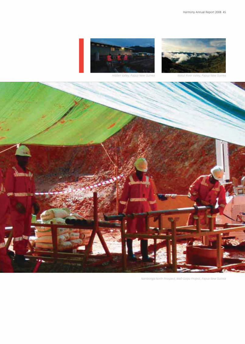
Hidden Valley, Papua New Guinea
Nambonga North Prospect, Wafi-Golpu Project, Papua New Guinea
Watut River Valley, Papua New Guinea

46 Harmony Annual Report 2008
Harmony’s exploration strategy is to focus on key prospective
geological terrains to create shareholder value through the discovery of
large long-life gold orebodies.
Mine development
Geochemicalanomalies
targets
Prospects withsignificant intercepts
Advanced projects
Resource definition
Pre-feasibility
Project generation
PNG project inventory
Aerial photography
Data integration
Geochemistry
Drilling
Geology
Prospect ranking
Satellite imagery
Detailed magnetics
Database validation
Electrical geophysics
EL 440
EL 1316
EL 1105
Big WauSalemba
Tais CkYava
Plant siteRidge
Upper Bulolo
Little Wau
Waterfall
Big Wau
Wafi-GolpuPFS
HiddenValleyProject
Hidden Valley
Hamata
Kaveroi
Golpu Porphyry Cu/Au
Link Zone
A Zone
NRG1
B Zone
Western Zone
Nambonga North
KaveroiNth
Nosave
Bulldog
Apu Ck
Andim
Yafo
Kerimenge
Daulo
Waurike
Ketenge
Lemenge
UpperRidges
KauriUpper Namie
Kopakaia
Repeater ST T/O
Upper Little Wau
KambuWanameto
Wavlye
Kudjeru
Kulang
KakaroBiaru River
Alans Lode
Indiwi RiverGr
Udat Ck
Kalamansi Ck
Moka Ck
Tumbe Ck
MorobeCoast
Mossy Knoll
White Cat
Iwalevi-Kobiak
Moa Ck
EL 1103ML 151
EL 497
ELAs1629-1630
EL 667
EL 1403
EL 1193
Biamena
Bakau
Susuwami
C Zone
Northern Zone
Malaria WestZoneAwembu
Nambonga-Yor-SabumaBawaga
Heking
Portru
Zilani
Big Wau
Plant t site ridgeTais CreekYava
Little Wau
Waterfall
NambongaMalaria Zone
Kesiago
Heyn
PNG project inventory, showing the pipeline of prospects which range from grassroots geochemical and magnetic targets through to deposits
undergoing resource definition, prefeasibility studies and the Hidden Valley Project currently in construction. The axis on the right provides a guide
to lead times from discovery to development.
5 years
10 years
2 years
After prospectivity, investment decisions on new
exploration opportunities are also shaped by:
■ Project- and country-related risks.
■ The ability to meet minimum filter criteria (potential
size/production profile).
Harmony has adopted a flexible approach in that
exploration can be undertaken in-house or as joint
venture partnerships, and can involve both greenfields
(no infrastructure) and brownfields (existing mine
infrastructure) work.
In FY08, Harmony’s greenfields exploration effort focussedalmost entirely on Papua New Guinea (PNG). Its approachhas been to develop and maintain a balanced projectpipeline across all levels of the exploration process, ranging
from grassroots geochemical and geophysical anomaliesthrough to advanced prospects, resource definition, andprojects moving into feasibility. A total of A$19.2 million($17 million or R125 million) was spent on PNG explorationduring FY08. The group’s exploration budget is set for FY09at R351 million (60% in PNG).
Although this is a long-term process, Harmony has had
a successful year of exploration in PNG with two
prospects worthy of particular note:
■ Nambonga North Prospect. This prospect was
generated from base datasets and progressed to
advanced prospect stage in less than 12 months.
Results have been highly encouraging. It represents a
new zone of porphyry style copper-gold
mineralisation, which was previously unknown at Wafi-
Golpu, and has the potential to have a major positive

Harmony Annual Report 2008 47
Hidden Valley, Papua New Guinea Hidden Valley, Papua New Guinea
impact on the prefeasibility study. Drilling to define the
limits of mineralisation and scope out the size of the
deposit continues with three drill rigs on site.
■ Biamena Prospect was advanced from a grassroots
geochemical target with initial drilling returning ore
grade intercepts. This project has the potential to
deliver a multi-million ounce deposit similar to that of
the Wafi-Golpu project.
The group’s exploration programme in South Africa was
curtailed in August 2007, although work in the Evander
area (discussed below) has recommenced.
Papua New Guinea
The majority of exploration expenditure during FY08
was in PNG on our land holding around the Wafi-Golpu
and Hidden Valley projects. This tenement package
comprises some 3 276km2 of tenure located entirely
within the Morobe Province.
On a regional scale the Morobe district forms part of the
New Guinea Mobile belt. This metallogenic belt hosts a
number of world-class deposits including the Grasberg-
Ertzberg and OK Tedi porphyry copper-gold deposits,
and the Porgera gold deposit. In line with the exploration
strategy, opportunities to expand further in this highly
prospective geological terrain will be monitored closely.
Locally, the Morobe district has a known mineral
endowment of over 18 million ounces of gold, 89 million
ounces of silver, 3.9 billion pounds of copper and
47 million pounds of molybdenum. The region is
underexplored and has demonstrable potential for the
discovery of major multi-million ounce gold deposits
and copper-gold porphyry deposits. The project pipeline
has numerous quality prospects which have had little
more than surface sampling or magnetics completed by
way of first pass exploration. The group’s strategy here
is to capitalise on this exploration opportunity and
realise value by developing the district into a major
mineral province with multiple mines.
During FY08, initiatives to accelerate prospect turnover
and development of the pipeline has included building
the exploration team numbers to a staff of 16 national
geologists, increasing drilling capacity through new
drilling contractors, and increasing sample volumes and
decreasing turnaround times for assay samples
through the laboratory.
This momentum is set to increase in the forthcoming
year, as the new joint venture with Newcrest Mining
Limited will continue building a strong base for its
exploration activities. A budget of $A19.6 million
($18 million) for exploration in Morobe Province
(45% for greenfields, 55% for brownfields activities) has
been approved for FY09.
Lae
1000
Km
Tenement location map

48 Harmony Annual Report 2008
Exploration review (continued)
Wafi-Golpu
Wafi brownfields exploration
Exploration in the immediate area surrounding the
existing deposits at Wafi and Golpu was the cause of
much excitement during the year, particularly with the
discovery of porphyry-style copper-gold mineralisation
at the Nambonga North Prospect.
Nambonga North
The Nambonga North prospect lies approximately
2km north-west of Golpu. The prospect was prioritised for
follow-up work based on a magnetic target coincident with
an electromagnetic conductor and anomalous copper-
molybdenum geochemistry at surface.
Drilling at the prospect during FY08 comprised 13 holes
for 5 827 metres. Porphyry gold-copper intercepts
obtained from the programme to date include:
WR262: 178m @ 1.2g/t gold, 0.3% copper from 232m
WR264: 213m @ 1.1g/t gold, 0.3% copper from 300m
WR272: 199m @ 1.1g/t gold, 0.28% copper from 292m
WR268: 30m @ 1.42g/t gold, 0.37% copper from 276m
WR270: 150m @ 0.8g/t gold, 0.23% copper from 320m
WR275: 180m @ 1.0g/t gold, 0.25% copper from 383m
Mineralisation generally occurs as banded quartz,
magnetite, chalcopyrite, (± pyrite, ± hematite) vein
stockwork developed in both diorite porphyry, and the
surrounding metasediments of the Owen Stanley
Metamorphics. The host rocks are variably silicified and
sericite altered. The association of hydrothermal
magnetite with the mineralisation (also at Golpu in the
potassic zone) has important implications for the
regional prospectivity and exploration programme.
In addition to porphyry gold-copper mineralisation, the
drilling at Nambonga North has outlined gold-base
metal mineralisation in the form of a massive sulphide
lens off the hanging wall contact of the intrusive.
Results include:
WR258: 74m @ 5.6g/t gold, 4.3% zinc, 1.2% lead and
54g/t silver from 125m
WR264: 6m @ 3.6g/t gold, 5.3% zinc, 1.1% lead and
27g/t silver and from 286m
WR269: 12m @ 2.87g/t gold, 4.9% zinc, 0.8% lead and
10.6g/t silver from 156m
WR272: 10m @ 1.6g/t gold, 0.6% zinc, 0.3% lead and
26.7g/t silver from 282m
WR273: 11m @ 5.0g/t gold, 3.8% zinc, 1.2% lead and
14g/t Ag from 201m
Nambonga North has the potential to develop into a
major new resource, in excess of one million ounces
(with additional copper and base metal credits) for the
Wafi-Golpu project.
Drilling to scope out the deposit will remain a priority in
the first half of FY09.
The New Guinea Mobile Belt spans the core of the Irian Jaya – PNG mainland and represents one of the world’s most
prospective geological terranes for porphyry copper-gold and epithermal gold mineralisation. This belt of remote and rugged
mountainous country contains major gold and copper-gold deposits including OK Tedi (copper-gold), Grasberg-Ertzberg (copper-
gold), Porgera (gold), Misima (gold), Frieda River (copper-gold), Bulolo (gold) and Harmony’s deposits at Hidden Valley (gold-
silver) and Wafi-Golpu (gold and copper-gold). The belt is underexplored and remains a major focus for additional opportunities.
Harmony Annual Report 2008 49
Hidden Valley, Papua New Guinea Wafi-Golpu, Papua New Guinea
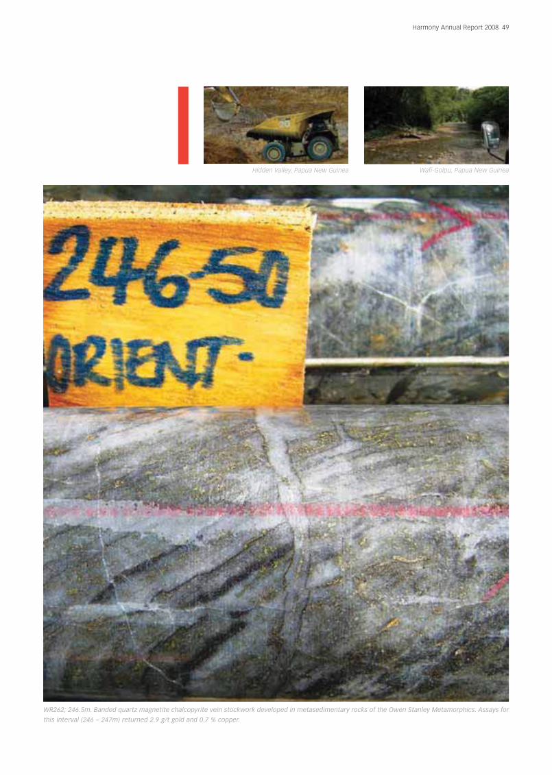
WR262; 246.5m. Banded quartz magnetite chalcopyrite vein stockwork developed in metasedimentary rocks of the Owen Stanley Metamorphics. Assays for
this interval (246 – 247m) returned 2.9 g/t gold and 0.7 % copper.
50 Harmony Annual Report 2008
Exploration review (continued)
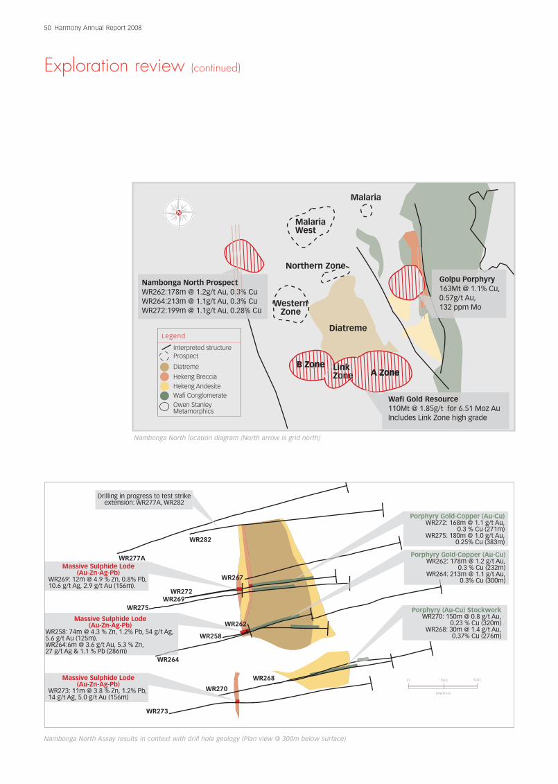
MalariaWest
Northern Zone
WesternZone
Malaria
A ZoneLinkZone
B Zone
DiatremeLegend
Interpreted structureProspect
Diatreme
Hekeng BrecciaHekeng AndesiteWafi ConglomerateOwen StanleyMetamorphics
Nambonga North ProspectWR262:178m @ 1.2g/t Au, 0.3% CuWR264:213m @ 1.1g/t Au, 0.3% CuWR272:199m @ 1.1g/t Au, 0.28% Cu
Golpu Porphyry163Mt @ 1.1% Cu,0.57g/t Au,132 ppm Mo
A ZoneB Zone
Wafi Gold Resource110Mt @ 1.85g/t for 6.51 Moz AuIncludes Link Zone high grade
Nambonga North location diagram (North arrow is grid north)
WR277A
WR282
WR275
WR272WR269
WR258
WR262
WR267
WR270
WR273
WR268
Drilling in progress to test strikeextension: WR277A, WR282
WR272
WR26
Massive Sulphide Lode(Au-Zn-Ag-Pb)
WR269: 12m @ 4.9 % Zn, 0.8% Pb,10.6 g/t Ag, 2.9 g/t Au (156m).
WR262Massive Sulphide Lode
(Au-Zn-Ag-Pb)WR258: 74m @ 4.3 % Zn, 1.2% Pb, 54 g/t Ag,5.6 g/t Au (125m).WR264:6m @ 3.6 g/t Au, 5.3 % Zn,27 g/t Ag & 1.1 % Pb (286m)
WR264
WR270
Massive Sulphide Lode(Au-Zn-Ag-Pb)
WR273: 11m @ 3.8 % Zn, 1.2% Pb,14 g/t Ag, 5.0 g/t Au (156m)
Porphyry Gold-Copper (Au-Cu)WR272: 168m @ 1.1 g/t Au,
0.3 % Cu (271m)WR275: 180m @ 1.0 g/t Au,
0.25% Cu (383m)
Porphyry Gold-Copper (Au-Cu)WR262: 178m @ 1.2 g/t Au,
0.3 % Cu (232m)WR264: 213m @ 1.1 g/t Au,
0.3% Cu (300m)
Porphyry (Au-Cu) StockworkWR270: 150m @ 0.8 g/t Au,
0.23 % Cu (320m)WR268: 30m @ 1.4 g/t Au,
0.37% Cu (276m)
50 1000
Metres
Nambonga North Assay results in context with drill hole geology (Plan view @ 300m below surface)

Harmony Annual Report 2008 51
Nambonga North Prospect, Papua New Guinea Wafi, Papua New Guinea
Nambonga North Prospect, Papua New Guinea

Wafi greenfields exploration
Porphyry copper-gold and stand-alone gold targets
represent the best potential to crystallise value from the
Wafi mining tenement group. Reprocessing of regional
magnetics has outlined a number of discrete magnetic
targets within a 14km radius of the Wafi-Golpu project.
These anomalies all have the potential to deliver major
gold or copper-gold systems in areas where there has
been little or no previous exploration.
FY08 exploration has focused on the Biamena Prospect.Negotiations to access Ghavembu (on EL440) andKesiago (EL1103) Prospects were also successful duringthe year and work programmes including surfacetrenching, mapping and initial drilling are now underway.
52 Harmony Annual Report 2008
Exploration review (continued)
Masivesulphur
Stocks work quartzveins in metasediments
Metasediments
Lowerporphyryunit
Unmineralisedporphyry
MassiveSulphide
Metasediments
WR279WR275 WR272 WR269 WR267
Loweporphunit
Massive Sulphide Lode (Au-Zn-Ag-Pb)WR269: 12m @ 4.9 % Zn, 0.8% Pb,10.6 g/t Ag, 2.9 g/t Au (156m).WR272: 10m @ 0.6 % Zn, 0.3% Pb,26.7 g/t Ag, 1.6 g/t Au (282m)
Porphyry (Au-Cu)WR272:199m @ 1.1 g/t Au,0.28 % Cu (292m)
k quartzetasediments
Porphyry (Au-Cu)WR275: 199m @ 1.0 g/t Au,0.25% Cu (383m)
Weakly mineralised lowerporphyry body96m @ 0.4 g/t Au,0.12%Cu (600m)
WR279 drillingin progress
Mineralisedporphyry
50 1000
Metres
Oblique drill section showing recent intercepts and geology at Nambonga North. Mineralised porphyry remains open to the north
and south, off the grid.
Biamena Prospect
The Biamena prospect is located approximately 12kmsouth-south-east of Wafi and is prospective forepithermal gold and porphyry copper-gold mineralisation.
Work completed during FY07 obtained a number ofpromising mineralised gold zones from channelsampling of surface trenches. Ridge and spur soilsampling was also completed and outlined a majorcoincident copper-gold anomaly (open to the south).
Work by Harmony during FY08 included:
■ Drilling (2 holes / 749m)
■ Surface geophysical surveys including
– Induced polarisation (IP) survey
– Electromagnetic (EM) survey
■ Reconnaissance geological mapping and rock chip
sampling
The work programme has advanced the Biamenaprospect from a grassroots magnetic target withanomalous coincident surface geochemistry to aprospect with promising intercepts of ore-grademineralisation in drill core.
Initial drilling produced a number of significantintercepts including:
BMA002: 24m @ 3.41g/t gold from 177m
Includes: 11m @ 5.38g/t gold from 181m.
This intercept is particularly significant as no previous
drilling exists in the area and mineralisation
encountered is completely open.
The IP and EM geophysical surveys were designed to
outline:
■ blind porphyry copper gold-targets at depth (similar
to that of Golpu), and
■ areas of disseminated sulphide mineralisation and
silicification which may be associated with gold
mineralisation.
Preliminary results from the 3D inversion of the IP data
show a chargeable annulus around a magnetic core.
This is consistent with the response expected from a
porphyry system. A similar response was recorded at
Wafi-Golpu. Data processing and imagery is underway
and the geophysical datasets will be integrated with
surface geology and geochemistry to highlight targets
and guide initial follow-up drilling.
Reconnaissance geological mapping on the lines cut for
the geophysical surveys have already outlined several
new zones of mineralisation south of the main prospect
area. Rock chip sampling obtained high-grade gold,
silver and base metal assays up to 88g/t gold, 400g/t
silver, 5.8% copper and 2.3% lead. The results more than
double the footprint of the anomalous area at Biamena,
and highlight the prospectivity of the area for porphyry
copper-gold and related epithermal gold mineralisation.
Ghavembu Prospect
The Ghavembu prospect is located 1.5km south of the
Wafi-Golpu prospect and is associated with the north-
east trending Wafi Transfer. The prospect was initially
defined in the 1980s by CRA Exploration (Pty) Ltd with
reconnaissance stream sampling. Subsequent
Harmony Annual Report 2008 53
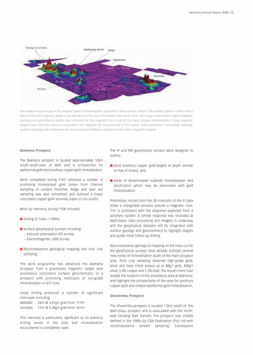
This diagram is an image of the analytic signal of aeromagnetic data with a linear colour stretch. The analytic signal is a filter which
tries to force the magnetic peaks to lie directly over the top of the bodies that cause them.The image shows where highly magnetic
porphyry and granodiorite bodies have intruded the non-magnetic host rocks of the Owen Stanley Metamorphics. These magnetic
targets have had little previous exploration and highlight the prospectivity of the region. Initial exploration comprising mapping,
surface sampling and predominantly reconnaissance drilling is planned to test these magnetic targets.
Bawaga Anomalies
Kesiago
Nambonga North Golpu
Ghavembu
EL1 103EL440
EL1 105
EL1 316
Biamena
54 Harmony Annual Report 2008
Exploration review (continued)
grid-based soil sampling delineated a porphyry related,
multi-element gold-copper-molybdenum anomaly,
which is similar in size and tenor to the surface
anomaly located over the Golpu deposit. The anomaly is
also flanked by several discrete magnetic targets
suggesting intrusives at depth.
The footprint of the anomaly, potential size, and
proximity to the Wafi-Golpu project combine to rank this
prospect as a priority target for follow-up in the first
quarter of FY09.
Kesiago
The Kesiago anomaly covers an area of approximately
3km2 and is located 2.5km south-west of the Golpu
porphyry copper-gold deposit. It is associated with the
north-east/south-west trending Wafi transfer structure.
The prospect comprises a magnetic anomaly supported
by elevated levels of gold and copper in stream-
sediment geochemical results.
Although reconnaissance work including trenching and
drilling was planned for the second quarter of 2008,
protracted access negotiations delayed the start of the
programme. Negotiations to access the ground have
now concluded and drill site preparation is currently in
progress. Drilling is planned to begin in the first quarter
of FY09.
Bawaga
The Bawaga magnetic anomalies lie approximately
5km north of the Wafi-Golpu project and is also highly
prospective for epithermal gold and porphyry copper-
gold mineralisation. Reprocessed magnetics outline a
number of anomalies associated with north-east
trending transfer structures in a similar structural
setting to that of the Wafi-Golpu system.
Data compilation has highlighted the fact that most of
the Bawaga magnetic targets held within EL1105 have
had no previous exploration. This represents a major
opportunity given the relationships established with the
landowner groups during the Wafi prefeasibility
studies. Negotiations to access this area are currently
under way.
Hidden Valley brownfields exploration
Project generation work was the main focus of the
Hidden Valley mining lease exploration programme
during FY08. Some 2 824 ridge and spur soil samples,
25 line kilometres of geological mapping and 7 675 rock
chip and continuous channel samples were collected
from new trenches and exposures associated with new
mine infrastructure. Work integrating the geological and
geochemical datasets together with detailed
helimagnetics is currently being completed to provide a
new solid geological interpretation to identify additional
targets on the Hidden Valley mining lease.
Results have prioritised Upper Bulolo, Yafo and Big Wau
for follow-up work. Both Upper Bulolo and Yafo
prospects have good potential for high-grade gold
mineralisation to supplement the ore feed from Hidden
Valley, and surface trenching and mapping activities at
these prospects are under way to outline the full extent
of the anomalies to optimise first pass drilling.
Drilling at Salemba was also completed during the year
but results have downgraded the prospect.
Hidden Valley greenfields exploration
Exploration in the region around Hidden Valley aims to
add value through the discovery of major satellite
resources, or to provide a high-grade sweetener to
supplement the ore feed for Hidden Valley processing
plant. Although the area is highly prospective for bulk-
tonnage low-grade deposits similar to Hidden Valley,
examples of high-grade deposits in the district include
Edie Creek, mined in the 1920s with a historical
production of 2.7Mt @ 8.4g/t gold for 730Koz and Wau
with a historical production of 2.6Mt @ 6.5g/t gold for
560Koz.
Harmony’s exploration work during FY08 was focused
on development of the prospect areas surrounding the
historical deposit at Kerimenge and understanding
mineralisation controls. This included work at the Daulo
Prospect.
Kerimenge
The Kerimenge deposit is located approximately 7km
east of the processing plant site currently under
construction for the Hidden Valley Project. Historical
work has focused on the main mineralised zone at
Kerimenge but geometry and grade continuity of
mineralisation are poorly understood.
Work during FY08 focused on understanding
mineralisation controls by investigating the potential of
prospect areas around the deposit. More than four line
kilometres of hand dug trenches were completed and
mapped, and some 2 036 samples were collected
and assayed.
Trenching and mapping activities to the east of the
deposit outlined a new zone surface gold
mineralisation. The zone was defined over an area over
300m long and up to 30m wide but remains open
ended. Results from continuous channel sampling
include:
Harmony Annual Report 2008 55
Wafi-Golpu, Papua New Guinea Hidden Valley, Papua New Guinea
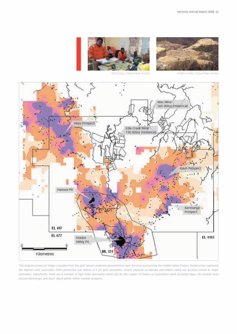
This diagram shows an image compiled from the gold stream sediment geochemistry over the area surrounding the Hidden Valley Project. Purple areas represent
the highest order anomalies (98th percentile) and define +0.9 g/t gold anomalies. Clearly deposits at Hamata and Hidden Valley are located central to major
anomalies. Importantly, there are a number of high-order anomalies which will be the subject of follow-up exploration work including Heyu, the broader area
around Kerimenge, and Kauri. Black points reflect sample locations.
56 Harmony Annual Report 2008
Exploration review (continued)
KTK02: 20m @ 3.4g/t gold; 24m @ 3.2g/t gold;
10m @ 7.07g/t gold
KTK03A: 16m @ 3.2g/t gold; 4m @ 22.5g/t gold;
4m @ 8.23g/t gold
KTK03B: 8m @ 5.7g/t gold; 12m @ 3.88g/t gold
These intercepts are associated with a north-west
trending shear zone which has been intruded by
porphyry. No previous work has been undertaken in the
area and follow-up drill testing is proposed for FY09.
Daulo Prospect
The Daulo prospect is located approximately 1km
south-west of the Kerimenge deposit
Historical trench results at the prospect include: 56.8m
@ 3.83g/t gold; 27.8m @ 5.76g/t gold. Follow-up drilling
was sporadic but included six drill holes (600m) with
some significant intercepts including DP01: 12m @
4.80g/t gold from surface and DP03; 5m @ 5.6g/t
gold from 62m (BOH intercept). Mineralisation was
associated with sheared and brecciated phyllites of the
Owen Stanley Metamorphics.
Work completed by Harmony during FY08 included
validation sampling and mapping and some trench
work to understand the controls of mineralisation.
Continuous channel sampling of trenches returned
several significant intercepts including:
DLO1A: 10.8m @ 5.35g/t gold
DLO3A: 45m @ 4.6g/t gold
DLO4B: 23m @ 2.2g/t gold
Mineralisation at Daulo appears fault bounded.
Mapping shows the majority of minor structures
exposed in the trenches are oriented similar to Edie
Creek, dipping 60 to 70 degrees to the south-east.
The work has highlighted good potential for shallow,
high-grade, oxide gold mineralisation within a 6km
radius of the Hidden Valley plant. A proposal for follow-
up drilling to test the size potential of the prospect is
under way. A programme of systematic soil sampling,
mapping trenching and rock chip sampling, has been
designed to tie down mineralised trends, with an
allocation for follow-up diamond drill testing in FY09.
Morobe Coast greenfields exploration
The Morobe Coast exploration licence EL1403
encompasses some 1 041km2 of tenure. The area lies to
the south-east of the Morobe goldfield and Harmony
believes it presents excellent grassroots exploration
potential for high-grade low-sulphidation epithermal
mineralisation. With the exception of anomalous gold
assays from rock-chip and stream-sediment samples
from the Lokaniu volcanics, there has been very little
previous exploration on the tenements, and no drill
testing has been undertaken on the tenement to date.
Giu Prospect
The Giu Prospect falls approximately 10km south-west
of the Morobe township on the east coast of PNG and
was the main focus of exploration activities on EL1403.
The prospect represents a district-scale anomaly, 20km
in diameter with elevated gold rock chip and stream
sediment geochemistry. The aim of the work
programmes is to identify and develop prospect areas
with the potential for stand-alone gold (+ related metal)
orebodies.
Some 400 stream-sediment and rock chip samples
were collected during FY08 and several highly
anomalous drainage areas were identified where -80
mesh stream-sediment samples returned assays in
excess of 0.4g/t gold. This stream-sediment anomaly
encompasses an area of over 8km2.
Mapping and rock chip sampling undertaken in
conjunction with the stream-sediment sampling
programme has obtained assays of up to 67g/t gold
from mineralised coloform-banded infill breccias.
Field work in the form of ridge and spur soil sampling is
scheduled for FY09 in order to trace the anomaly to its
bedrock source. An airborne magnetic survey is also
planned for FY09 to provide additional base data for
integration with surface geochemical results and to
assist with drill targeting.
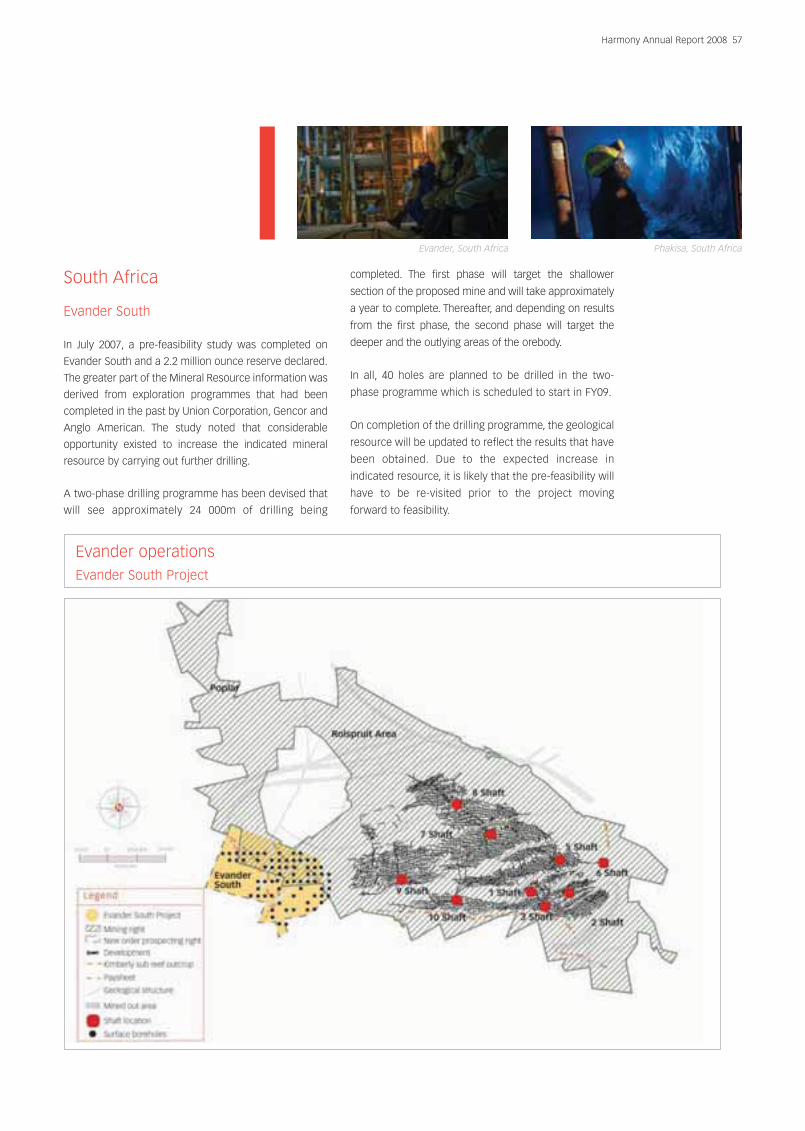
South Africa
Evander South
In July 2007, a pre-feasibility study was completed on
Evander South and a 2.2 million ounce reserve declared.
The greater part of the Mineral Resource information was
derived from exploration programmes that had been
completed in the past by Union Corporation, Gencor and
Anglo American. The study noted that considerable
opportunity existed to increase the indicated mineral
resource by carrying out further drilling.
A two-phase drilling programme has been devised that
will see approximately 24 000m of drilling being
completed. The first phase will target the shallower
section of the proposed mine and will take approximately
a year to complete. Thereafter, and depending on results
from the first phase, the second phase will target the
deeper and the outlying areas of the orebody.
In all, 40 holes are planned to be drilled in the two-
phase programme which is scheduled to start in FY09.
On completion of the drilling programme, the geological
resource will be updated to reflect the results that have
been obtained. Due to the expected increase in
indicated resource, it is likely that the pre-feasibility will
have to be re-visited prior to the project moving
forward to feasibility.
Harmony Annual Report 2008 57
Evander, South Africa Phakisa, South Africa
Evander operations Evander South Project