1 producing “broad-brush” water resource balances at the eea level under the seeaw methodology....
TRANSCRIPT

1
Producing “broad-brush” water resource Producing “broad-brush” water resource balances at the EEA level under the balances at the EEA level under the
SEEAW methodology.SEEAW methodology.Towards regular production of water resource accountTowards regular production of water resource account
Philippe CrouzetBSS2 /Spatial group

2
Place of the accounts in the processPlace of the accounts in the process
• Immediate term: 2008 water resource report, provisional data flows• Report output, issues analysis• Fuelling water resource accounts with best available data
• From now, for the next 4 years: implementing water resource accounts• Assessing data gaps and data inconsistencies,
harmonising data sources vs. nomenclatures• Capacity building for the regular WA production• Testing SEEAW on a large area (only limited experiments
for the time being)• Fuelling the indicators from optimal data

3
What are What are natural assets resource natural assets resource accountsaccounts??
• SEEA 2003, is a satellite system of the System of National Accounts. It comprises:• Flow accounts for pollution, energy and materials. • Environmental protection and resource
management expenditure accounts• Natural resource asset accounts. These accounts
record stocks and changes in stocks of natural resources such as land, fish, forest, water and minerals
• Valuation of non-market flow and environmentally adjusted aggregates
• The water sub-system (SEEAW) is a conceptual framework for the organization of physical and economic information related to water, consistent to those of the SEEA.
4
Accounting conceptual model applied to Accounting conceptual model applied to water assets accounts water assets accounts
Do gains compensate for losses? Can gain
substitute to losses?
Loss of stocke.g. by usage
Gain in stocke.g. by storage
Has the quality of the stock been maintained?

5
Accounting rationalesAccounting rationales
• The accounting algebra depends on the specificities of the asset:• water assets account is a compromise between stocks
and flows, with predominance of flows (e.g. rivers) or stocks (e.g. Glaciers, groundwater),
• Where flow dominated, availability is immediate, only storage spares for the future, limiting time compensation
• If physical transfer device does not exist (aqueduct, river, etc.), defining space compensation
• Processing resolution and aggregation rules must take these constraints into consideration

6
Relationship resource / demandRelationship resource / demand
• Same averages may result from opposed issues
• Both yearly average are WRI=0.31, vs. averages of monthly WRI being respectively 0.33 (left) and 0.71
Annual time step of accounting is relevant (even resource, even demand)
Annual time step does not show the water shortage (odd resource, seasonal demand)
7
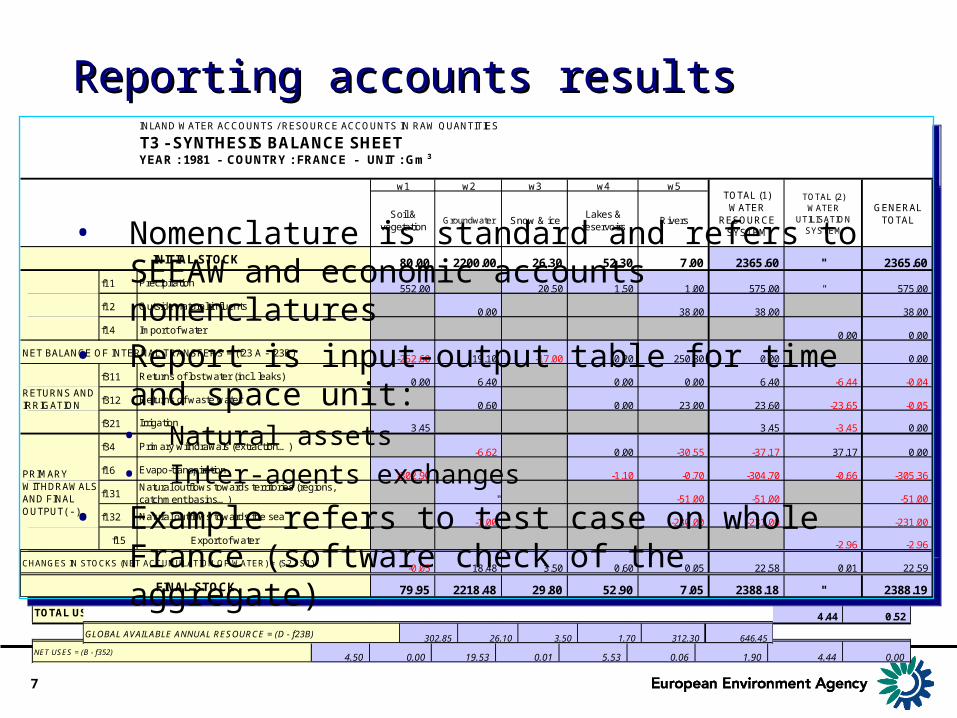
Reporting accounts resultsReporting accounts results
INLAND WATER ACCOUNTS / RESOURCE ACCOUNTS IN RAW QUANTITIES
T1 - ACCOUNT OF THE USES OF THE WATER RESOURCEYEAR : 1981 - COUNTRY : FRANCE - UNIT : Gm³
T1A - WATER RESOURCE AND USE BY sectors
u1 u2 u3 u4 u5 u6 u7 u8 u9
Used resource
Users Agriculture FisheriesEnergy
(hydopower and cooling)
MiningManufacturing
industry
Distribution of water for irrigation
Distribution of drink water (incl.
communal services)
Sewerage
Other government
services (incl. urban cleaning,
canals)
f34a Extraction from groundwater 1.30 0.07 1.70 3.50
f34b Withdrawal from surface water 2.90 19.53 3.47 0.33 2.10 2.22
0.30 0.00 0.00 0.00 0.82 0.00 0.60 2.08 0.66
4.50 0.00 19.53 0.07 5.99 0.33 6.20 2.08 2.88
0.00 0.00 0.00 0.06 0.46 0.27 4.30 0.00 0.52
f151 Export of water for delivery0.01
f152bExport of waste water to the sea
2.53 0.01 0.42
0.17 0.29 0.07
f311 Returns of lost water (incl. leaks)1.05 0.64 0.06 1.90 2.19
f312 Returns of waste water16.83 4.60 1.75
3.45
4.50 0.00 19.53 0.07 5.99 0.33 6.20 4.44 0.52
4.50 0.00 19.53 0.01 5.53 0.06 1.90 4.44 0.00
TOTAL WATER RESOURCE BY USERS
Primary withdrawals (extraction…)
Import of water
Supply of water FROM other agents/sectors
Supply of water TO other agents/sectors
Evapo-transpiration
Export of water
TOTAL USE BY SECTORS (USERS)
NET USES = (B - f352)
Backflows (Returns of water)
Irrigation
T1B - MATRIX OF TRANSFERS (SUPPLY) BETWEEN SECTORS
u1 u2 u3 u4 u5 u6 u7 u8 u9
to recipient Agriculture FisheriesEnergy
(hydopower and cooling)
MiningManufacturing
industry
Distribution of water for irrigation
Distribution of drink water (incl.
communal services)
Sewerage
Other government
services (incl. urban cleaning,
canals)
" "
0.03 0.03
0.46
0.11 0.08 0.08
0.19 0.66 0.47 0.56
0.05 0.02 0.35 0.10
1.27
0.30 0.00 0.00 0.00 0.82 0.00 0.60 2.08 0.66Supply of water FROM other agents/sectors
Agriculture
Energy (hydopower and cooling)
from origin
Other government services (incl. urban cleaning, canals)
Households
Distribution of drink water (incl. communal services)
Sewerage
Mining
Distribution of water for irrigation
Manufacturing industry
Fisheries
T2A - TOTAL INPUT AND OUTPUT TO THE (FROM THE) WATER RESOURCE SYSTEM
w1 w2 w3 w4 w5
Soil & vegetation
Groundwater Snow & iceLakes &
reservoirsRivers
552.00 20.50 1.50 1.00 575.00
38.00 38.00
6.40 6.40
0.60 23.00 23.60
3.45 3.45
0.00 137.10 0.50 4.00 260.70 402.30
555.45 144.10 21.00 5.50 322.70 1048.75
252.60 118.00 17.50 3.80 10.40 402.30
6.62 30.55 37.17
302.90 1.10 0.70 304.70
51.00 51.00
1.00 230.00 231.00
302.90 7.62 0.00 1.10 312.25 623.87
-0.05 18.48 3.50 0.60 0.05 22.58
555.45 144.10 21.00 5.50 322.70 1048.75
302.85 26.10 3.50 1.70 312.30 646.45
SPONTANEOUS INTERNAL INPUT
TOTAL INPUT TO THE WATER RESOURCE SYSTEM
Evapo-transpiration
Primary withdrawals (extraction…)
Natural outflows towards territories (regions, catchment basins…)
Natural outflows towards the sea
Precipitation
Outside natural influents
Irrigation
Returns of lost water (incl. leaks)
Returns of waste water
SPONTANEOUS INTERNAL OUTPUT
TOTAL
WITHDRAWALS AND FINAL OUTPUT
TOTAL OUTPUT FROM THE WATER SYSTEM AND NET ACCUMULATION = (f23B + E + F)
GLOBAL AVAILABLE ANNUAL RESOURCE = (D - f23B)
CHANGES IN STOCKS (NET ACCUMULATION OF WATER) = (H - E)
T2B - INTERNAL TRANFERS BETWEEN HYDROLOGICAL SUB-SYSTEMS
w1 w2 w3 w4 w5 f23Bfrom origin to recipient Soil & Groundwater Snow & ice Lakes & Rivers SPONTANEOU
w1 Soil & vegetation
130.70 121.90 252.60
w2 Groundwater " 118.00 118.00
w3 Snow & ice 0.50 17.00 17.50
w4 Lakes & reservoirs " " 3.80 3.80
w5 Rivers " 6.40 4.00 10.40
f23 A SPONTANEOUS INTERNAL INPUT 0.00 137.10 0.50 4.00 260.70 402.30
INLAND WATER ACCOUNTS / RESOURCE ACCOUNTS IN RAW QUANTITIES
T3 - SYNTHESIS BALANCE SHEETYEAR : 1981 - COUNTRY : FRANCE - UNIT : Gm³
w1 w2 w3 w4 w5
Soil & vegetation
Groundwater Snow & iceLakes &
reservoirsRivers
80.00 2200.00 26.30 52.30 7.00 2365.60 " 2365.60
f11 552.00 20.50 1.50 1.00 575.00 " 575.00
f12 0.00 38.00 38.00 38.00
f14 Import of water 0.00 0.00
-252.60 19.10 -17.00 0.20 250.30 0.00 0.00
f311 0.00 6.40 0.00 0.00 6.40 -6.44 -0.04
f312 0.60 0.00 23.00 23.60 -23.65 -0.05
f321 3.45 3.45 -3.45 0.00
f34 -6.62 0.00 -30.55 -37.17 37.17 0.00
f16 -302.90 -1.10 -0.70 -304.70 -0.66 -305.36
f131 " -51.00 -51.00 -51.00
f132 -1.00 -230.00 -231.00 -231.00
f15 Export of water -2.96 -2.96
-0.05 18.48 3.50 0.60 0.05 22.58 0.01 22.59
79.95 2218.48 29.80 52.90 7.05 2388.18 " 2388.19
Outside natural influents
NET BALANCE OF INTERNAL TRANSFERS = (f23 A - f23B)
INITIAL STOCK
Precipitation
FINAL STOCK
CHANGES IN STOCKS (NET ACCUMULATION OF WATER) = (S2 - S1)
Evapo-transpiration
RETURNS AND IRRIGATION
TOTAL (1) WATER
RESOURCE SYSTEM
TOTAL (2) WATER
UTILISATION SYSTEM
GENERAL TOTAL
PRIMARY WITHDRAWALS AND FINAL OUTPUT( - )
Returns of lost water (incl. leaks)
Returns of waste water
Irrigation
Primary withdrawals (extraction…)
Natural outflows towards the sea
Natural outflows towards territories (regions, catchment basins…)
• Nomenclature is standard and refers to SEEAW and economic accounts nomenclatures
• Report is input-output table for time and space unit:• Natural assets• Inter-agents exchanges
• Example refers to test case on whole France (software check of the aggregate)

8
Aims of the “broad –brush” exerciseAims of the “broad –brush” exercise
• Obtain comparable results at the ‘Region basin’ (and sub-basin) and ‘RBD’ (and sub-unit) levels “ERC2” river GIS
• Implement calculation processes (Nopolu) in view of regular production,
• Test data quality and consistency, improve data flows, improve SEEAW methodology
• Deliver results to link with economic data and fuel EEA SoE and other assessments
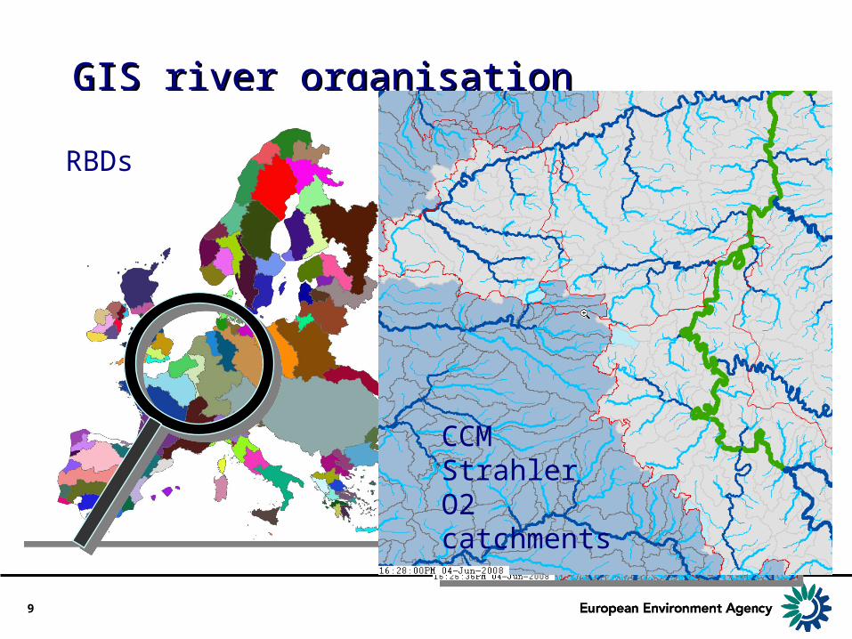
9
GIS river organisationGIS river organisation•Water flows following hydrological features, the only ones
that can yield consistent I/O tables, whereas WFD systems are blend of administrative and hydrological features: analytical levels and reporting levels are connected thanks to conceptual model:
RBDs
CCM Strahler O2 catchments

10
Analytical resolution and data issuesAnalytical resolution and data issues
• Region basins and sub-basin driven by geography plus WFD constraints, however:• Hydrological aggregation area < ~50,000
km2 for large homogeneous watersheds,• WFD aggregation driven by RBD and sub-
units, but RBD can be disjoined, very large, overlapping sea areas -> functional RBDs and functional sub-units
• Data disaggregation at the adequate analytical level is a complex issue, to solve by a feed-back process
Rhone/CH : >=2 FSU
Po / CH: >= 4FSU
11
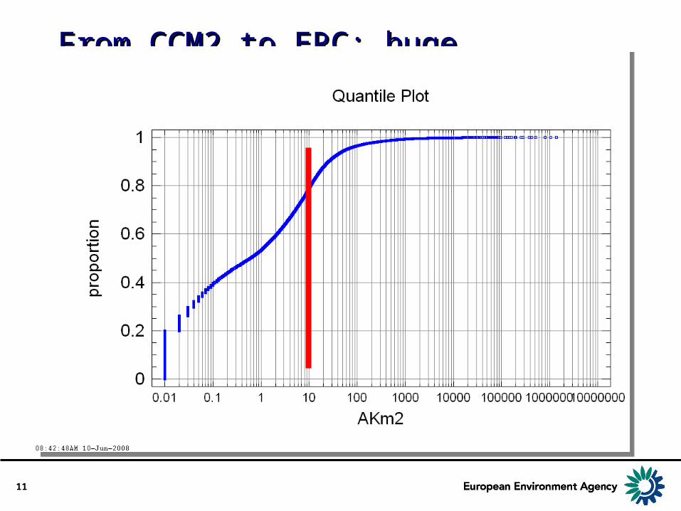
From CCM2 to ERC: huge preparationFrom CCM2 to ERC: huge preparation
• CCM2 “basins” (source for “Region basins”): 91,912 -11332 spurious= 80,580• At least 30,000 inconsistent, because of
area <0.1 km2• ~15,000 only > 10km2
• Poor information on sub-units jeopardises GIS building

12
Data sources and issuesData sources and issues
• Rainfall: ATEAM (ready) / MARS (signed provisional agreement) / ECMWF (underway)
• Run-off: On the basis of 500 -1000 analytical (unitary catchments), 500 to 4000 gauging stations monthly data required, process underway with ETC/W
• Usage data should follow the rule “accuracy results from precision in large components”, and is under progress
Urban areas and % of urban pop. vs. RBD limits
Urban areas and % of urban pop. vs. RBD limits
Country PU U/T NbOfUZLuxembourg 437513 456710 95.8 1Malta 360390 404107 89.2 2Germany 52007155 82500000 63 63France 38092895 60700000 62.8 133Denmark 3390250 5418313 62.6 4Czech Republic 5841807 10200000 57.3 13Netherlands 9319223 16300000 57.2 29Latvia 1314787 2300027 57.2 3Spain 24446813 43400000 56.3 43Cyprus 463562 835307 55.5 2Poland 19580964 38200000 51.3 34Lithuania 1748721 3415046 51.2 5Greece 5643316 11100000 50.8 9Ireland 2080448 4150566 50.1 5Sweden 4499633 9024040 49.9 11Estonia 663458 1345005 49.3 2Portugal 5111779 10600000 48.2 14Norway 2089858 4618450 45.3 6Austria 3604284 8211359 43.9 5Italy 24344471 57500000 42.3 47Belgium 4370359 10500000 41.6 7Hungary 4194369 10100000 41.5 9Slovenia 799367 1998200 40 2Finland 1905092 5245071 36.3 4Bulgaria 2763179 7740928 35.7 7Romania 7448160 21600000 34.5 27Slovakia 1799272 5387152 33.4 8Switzerland 2139013 7440711 28.7 4Together 230460138 440690992 52.3 499
13
Ways data shall be processed and Ways data shall be processed and included: Rainfallincluded: Rainfall
• Raw: from data, control vs. recent sources and homogenisation,
• Evaporation: likely to be modelled with temperature and vapour pressure (Turc or likely Penman formula, since vapour pressure is available (albeit wind is not) and vegetation cover known from CLC or taken from only recent data sets

14
Ways data shall be processed and Ways data shall be processed and included: run-offincluded: run-off
• From gauging stations, monthly data, extrapolated between stations or nodes, taking abstractions and returns into account
• Storage: only large lakes and reservoirs considered (data source Eldred2 and lakes layers). Where local storage changes are known, they are considered, especially where refilling is one over N years.

15
Ways data shall be processed and Ways data shall be processed and included: groundwaterincluded: groundwater
• Only major aquifer systems to be delineated (no EU GW GIS available), supported by inputs from EGS,
• Data from WaterBase / data collection at the RBD.
• Groundwater inflow / outflow if a weak point of the hydrosystems functioning knowledge for the time being

16
Ways data shall be processed and Ways data shall be processed and included: abstractions and return flows included: abstractions and return flows (domestic and industry)(domestic and industry)
• From individual data for large sources, where available. Larges sources (threshold to define) are processed individually, even though no individual data exist (volume, origin of water, seasonalisation)
• Smaller sources processed statistically, by difference within a statistical data provision unit
• EPR data set mobilised to find industrial data• Sewage outputs considered when potentially
changing water balance (watershed transfer) and contributes to GW -> SW balance
17
Ways data shall be processed and Ways data shall be processed and included: seasonal demandsincluded: seasonal demands
• Tourism data poorly known, although making the largest seasonal changes in location of demand and returns (irrigation being only time depending)
• Origin of movements (minus demand) lesser known that target of movements (larger demand)

18
Ways data shall be processed and Ways data shall be processed and included: irrigationincluded: irrigation
• Data sources to refine, with the EEA specialists and agricultural experts from another framework contract
• Potential impact as dry-out of small water bodies not addressed in the broad-brush assessment.

19
Thanks for your attentionThanks for your attention