1. salient features of east godavari district - andhra pradesh · andhra pradesh, it flows through...
TRANSCRIPT

District Survey Report - 2018
DMG, GoAP
1
1. Salient Features of East Godavari District
East Godavari District which is one of the largest and the most populous district in the state of Andhra Pradesh, was successively ruled by Mauryas, Sathavahanas, Vishnu Kundins, Eastern Chalukyas, Cholas, Kakatiyas, Musunuri Chieftains, Kondaveeti Reddy Kings, Gajapathis, Kutubshahis and then by the British. It was under the Raj. On April 15, 1925, East Godavari District was formed as per G.O.No.502. East Godavari is the richest district of the state, in terms of GDP. It is both the cultural and tourist hub of the state. East Godavari is a district in Coastal Andhra region of Andhra Pradesh, India. Its district headquarters is at Kakinada. As of Census 2011, it became the most populous district of the state. Rajahmundry and Kakinada are the two large cities in the Godavari districts in terms of population. The district of Rajahmundry (present name Rajamahendravaram) was reorganised in 1859 into two districts of Godavari and Krishna. Godavari District was further bifurcated into East and West Godavari districts in 1925. After Nov 1956, Andhra Pradesh was formed by combining parts of Naizam, Ceded and Circars. In 1959, the Bhadrachalam revenue division, consisting of Bhadrachalam and Naguru Taluqs (2 Taluqas in 1959 but later subdivided into Wajedu, Venkatapruram, Charla, Dummugudem, Bhadrachalam, Nellipaka, Chinturu, Kunavaram, and Vara Rama Chandra Puram mandals) of East Godavari district were merged into the Khammam district. After June 2014's reorganisation and division of Andhra Pradesh, the Mandals of Bhadrachalam (with the exception of Bhadrachalam Temple), Nellipaka, Chinturu, Kunavaram and Vara Rama Chandra Puram were re-added to East Godavari District. The East Godavari District is bordered by river Godavari on the West and Bay of Bengal on Eastern side. The district flourishes with lands of fertile soils, good rain fall and balanced climatic conditions and possesses all the nature's hand work like perennial rivers, mountains, forests and also the sea coast. The district is enriched by huge water resources of River Godavari and major streams like Yeleru, Suddagedda, Pampa and Thandava. The Delta coastal line is around 150 Kms in the Eastern sea board

District Survey Report - 2018
DMG, GoAP
2
of India with minor ports at Kakinada and Odalarevu. The mean annual rainfall precipitation is 1219 mm and is mostly confined to the period from June to November. 1.1 Administrative Setup East Godavari District lies in between 16° 30' to 17° 00' N Latitude and 81° 30' to 82° 30'E Longitude and occupies a geographical area of 10,807 Sq. Km. with population of 51.515 lakhs (2011 census). The district has divided into 64 mandals (Fig. 1). These 64 mandals consists of 1,374 villages, 2 Municipal Corporation, 7 municipalities and 10 census towns. It is the one of the two districts, like Chittoor district to possess two municipal corporations namely, Kakinada and Rajahmundry. The 7 municipalities in the district include, Amalapuram, Mandapeta, Peddapuram, Pithapuram, Ramachandrapuram, Samalkota, and Tuni. After the merger of Dowleswaram, Hukumpeta and Katheru into Rajahmundry Municipal Corporation, there exist 7 census towns of Arempudi, Bandarulanka, Chidiga, Morampudi, Ramanayyapeta, Rampachodavaram, and Suryaraopeta.

District Survey Report - 2018
DMG, GoAP
3
Fig. 1 Administrative Boundaries of East Godavari District, Andhra Pradesh

District Survey Report - 2018
DMG, GoAP
4
1.2 Drainage The famous river Godavari is flowing in this District (Fig.2). Within the state of Andhra Pradesh, it flows through hilly terrain of the Eastern Ghats known as the Papi hills which explains the narrowing of its bed as it flows through a gorge for a few km, only to re-widen at Polavaram. Before crossing the Papi hills, it receives its last major tributary Sabari River on its left bank. The river upon reaching the plains begins to widen out until it reaches Rajamundry. Arma Konda or Jindhagada Peak (1,680 m (5,510 ft) above msl) located near Paderu which is the highest peak in the Godavari river basin as well as in Eastern Ghats. After crossing Rajahmundry, the Godavari splits into two branches which are called Vriddha Gautami (Gautami Godavari) and Vasishta Godavari. Again the Gautami branch splits into two branches namely Gautami and Nilarevu. Similarly, the Vasishta splits into two branches named Vasishta and Vainateya. These four branches which join the Bay of Bengal at different places, are forming a delta length of 170 km (110 mi) along the coast of the Bay of Bengal and is called the Konaseema region. This delta along with the delta of the Krishna River is called the Rice Granary of South India.

District Survey Report - 2018
DMG, GoAP
5
Fig. 2 Drainage Network and Surface Water bodies of the District
The Kolleru Lake having a shallow depression area of about 388.5 Sq. Km lies in Kaikaluru and Kalidindi mandals and is located between Krishna and Godavari delta, and spans into two districts - Krishna and West Godavari. It acts as a reservoir for drainage water of surrounding delta areas during monsoon and it dries up in summer. Kolleru Lake is the largest freshwater lake in Asia. The lake serves as a natural flood-balancing reservoir for these two rivers. The lake is fed directly by water from the seasonal Budameru and Tammileru rivers, and is

District Survey Report - 2018
DMG, GoAP
6
connected to the Krishna and Godavari systems by over 68 inflowing drains and channels. 1.3 Climate and Rainfall The Climate is comparatively moderate throughout the year except during the months of April to June when the temperature reaches a maximum of 48 deg. Centigrade. The normal rainfall of the district is 1280.0 mm. More than half of the rainfall is brought by South-West Monsoon while a large portion of the rest of the district receives rainfall from the North-East Monsoon also, during October and November. Almost in each and every mandal, automatic weather stations (AWS) are established by A.P. State Developmental Planning Society (APSDPS), Planning Department, Govt. of A.P. (Fig.3) and the data from these stations is received every day. The isohytes map is showing the rainfall status in East Godavari district (Fig. 4).
Fig. 3 Automatic Weather Stations of East Godavari District

District Survey Report - 2018
DMG, GoAP
7
Fig. 4 Distribution of Rainfall in East Godvari District, Andhra Pradesh

District Survey Report - 2018
DMG, GoAP
8
Table-1 Mandal Wise Average Annual Rainfall (mm) Mandal Wise Average Annual Rainfall (mm)
S No Mandal Name Jan Feb Mar Apr May Jun Jul Aug Sep Oct Nov Dec TOTAL
1 ADDATEEGALA 5.47 10.08 23.35 41.67 88.19 172.98 229.59 221.38 213.14 172.11 46.45 10.54 1234.95
2 AINAVILLI 3.93 6.25 9.83 11.84 48.20 127.62 174.39 188.10 190.21 215.44 103.58 22.60 1101.97
3 ALAMURU 6.19 7.82 7.12 10.69 49.90 118.62 190.73 204.50 182.01 177.33 81.19 17.14 1053.23
4 ALLAVARAM 8.73 4.79 8.86 11.97 50.61 130.11 182.14 227.13 202.98 221.76 127.51 20.67 1197.25
5 AMALAPURAM 5.15 7.35 7.04 15.83 55.18 132.32 207.82 222.59 189.63 257.93 137.07 24.06 1261.99
6 AMBAJIPETA 3.63 3.43 10.49 13.61 44.83 130.86 180.82 212.25 193.41 209.40 99.71 15.98 1118.42
7 ANAPARTHI 3.07 5.84 11.03 15.98 57.42 123.82 203.51 190.56 158.17 151.08 65.33 10.57 996.37
8 ATREYAPURAM 2.05 7.67 7.30 20.27 50.66 143.72 208.21 209.89 200.57 161.54 70.15 15.53 1097.54
9 BICCAVOLU 2.62 6.76 7.75 11.64 54.50 95.37 154.89 167.70 151.14 135.77 70.31 9.10 867.55
10 DEVIPATNAM 2.58 7.16 10.19 20.53 45.32 146.16 225.60 276.03 182.87 125.59 38.58 11.19 1091.79
11 GANDEPALLE 5.49 8.83 10.90 23.01 72.49 113.93 168.34 173.22 158.33 135.44 65.60 10.76 946.34
12 GANGAVARAM 3.59 8.67 16.67 23.69 78.51 145.21 194.72 203.86 197.09 158.60 43.96 9.98 1084.54
13 GOKAVARAM 6.01 9.25 13.81 22.80 70.39 141.56 213.43 182.61 193.71 131.57 44.17 9.39 1038.71
14 GOLLAPROLU 1.21 9.44 5.88 16.32 41.43 108.86 137.48 135.88 121.77 141.49 60.96 14.12 794.84
15 I POLAVARAM 6.91 12.79 8.56 11.58 68.26 136.79 196.92 213.47 206.08 255.86 156.33 26.06 1299.60
16 JAGGAMPETA 2.75 10.85 13.01 24.54 82.87 135.58 190.62 192.92 169.60 133.16 65.30 11.02 1032.21
17 KADIAM 3.16 6.44 10.23 21.10 59.07 135.35 227.31 206.94 199.01 157.81 64.82 9.26 1100.51
18 KAJULURU 4.93 16.25 7.41 18.95 73.25 122.74 181.56 177.89 184.74 252.25 126.39 16.32 1182.68
19 KAKINADA (RURAL) 0.98 12.21 7.64 20.52 52.05 125.95 158.93 181.46 184.59 215.10 76.40 16.84 1052.66
20 KAKINADA(URBAN) 6.35 9.31 5.85 15.37 73.06 125.27 174.23 170.56 176.53 197.74 119.81 12.97 1087.06
21 KAPILESWARAPURAM 5.99 9.72 11.55 9.63 61.43 121.31 209.64 208.09 207.24 205.45 88.60 12.47 1151.14
22 KARAPA 4.03 8.35 5.23 12.07 73.93 113.00 167.29 168.71 166.46 205.66 110.34 14.71 1049.78
23 KATRENIKONA 6.43 14.34 9.01 10.42 59.79 121.77 187.47 205.57 213.59 260.05 167.34 25.13 1280.90
24 KIRLAMPUDI 2.13 9.22 9.87 18.35 93.95 132.56 156.03 174.69 185.98 147.14 73.28 11.61 1014.81
25 KORUKONDA 7.45 7.27 13.63 30.53 73.27 138.63 221.88 226.85 152.59 139.80 47.18 10.84 1069.94
26 KOTANANDURU 4.92 12.26 15.80 30.89 87.48 110.59 134.61 124.46 189.90 179.59 65.07 11.99 967.55
27 KOTHAPALLEE 2.87 19.37 8.09 21.58 45.54 119.30 161.41 153.80 197.07 200.98 75.11 18.00 1023.10
28 KOTHAPETA 4.39 7.14 10.67 14.24 49.37 123.79 209.53 199.18 183.20 190.70 90.12 14.26 1096.58
29 MALIKIPURAM 9.69 9.43 8.24 17.92 67.87 111.85 205.95 200.48 189.83 253.19 114.74 18.65 1207.83
30 MAMIDIKUDURU 6.64 14.39 11.04 14.36 67.91 133.19 197.29 228.29 206.34 240.61 122.44 18.97 1261.48
31 MANDAPETA 2.13 5.51 8.69 14.55 59.88 130.06 195.40 204.17 177.38 182.95 77.59 10.47 1068.79
32 MAREDUMILLI 4.27 5.60 10.30 48.36 52.97 185.84 304.02 277.28 275.78 169.50 46.55 12.26 1392.72
33 MUMMIDIVARAM 5.70 7.44 7.42 14.84 48.70 131.75 189.17 208.10 200.06 257.57 137.85 24.35 1232.94

District Survey Report - 2018
DMG, GoAP
9
34 P GANNAVARAM 3.58 7.24 7.88 18.62 43.32 132.40 188.79 198.43 204.64 254.35 118.74 16.65 1194.65
35 PAMARRU 0.63 10.47 9.24 11.26 52.70 108.84 180.23 177.11 180.02 214.19 101.09 11.89 1057.66
36 PEDAPUDI 4.42 7.28 6.57 13.45 75.88 116.03 162.70 184.07 169.85 185.62 92.82 13.98 1032.67
37 PEDDAPURAM 5.36 10.76 11.21 22.78 77.90 126.61 190.07 189.92 180.01 172.36 88.02 11.20 1086.20
38 PITHAPURAM 5.66 15.59 10.76 22.96 65.97 124.77 175.46 169.19 174.20 172.25 87.79 10.97 1035.57
39 PRATHIPADU 3.24 10.66 14.95 28.89 87.73 133.27 171.06 170.23 175.76 158.04 58.08 7.21 1019.12
40 RAJAHMUNDRY RURAL 2.60 4.38 13.60 19.62 46.29 146.84 212.86 200.41 220.15 139.37 70.00 13.38 1089.49
41 RAJAMUNDRY(URBAN) 5.02 8.17 13.00 22.50 62.49 122.57 218.85 229.33 166.29 149.97 61.87 8.38 1068.45
42 RAJANAGARAM 5.14 10.18 15.03 23.06 72.20 133.00 202.24 215.88 173.53 146.46 64.05 9.21 1069.97
43 RAJAVOMMANGI 7.12 15.25 19.96 51.84 83.19 178.09 257.84 237.94 237.09 166.59 60.23 10.03 1325.18
44 RAMACHANDRAPURAM 3.87 7.79 7.70 15.88 51.32 125.94 190.98 182.61 170.43 195.80 104.08 15.35 1071.74
45 RAMPACHODAVARAM 7.00 13.18 17.25 33.82 77.81 169.31 232.30 249.65 220.34 184.70 53.87 16.87 1276.08
46 RANGAMPETA 2.10 10.22 9.58 18.10 58.58 120.43 183.83 189.36 151.14 152.09 59.26 10.34 965.02
47 RAVULAPALEM 4.96 7.96 12.90 10.88 55.89 122.40 205.64 196.34 186.77 169.66 72.95 10.29 1056.64
48 RAYAVARAM 2.59 8.09 6.59 11.42 61.57 130.98 212.27 187.33 162.91 171.31 73.83 10.66 1039.55
49 RAZOLE 7.35 7.53 9.01 16.78 49.67 119.41 193.55 213.04 176.52 225.75 111.66 25.51 1155.76
50 ROUTHULAPUDI 5.29 10.16 21.69 29.80 55.96 118.89 138.09 149.11 166.78 159.79 96.73 16.71 968.99
51 SAKHINETIPALLE 6.28 5.30 6.32 25.08 46.45 144.01 210.56 194.60 228.83 242.15 92.80 28.52 1230.88
52 SAMALKOTA 0.74 10.04 10.21 19.55 62.35 109.54 141.98 152.43 164.40 156.43 82.90 12.64 923.20
53 SANKHAVARAM 4.85 12.46 14.46 22.20 101.40 131.89 172.72 168.83 204.18 177.93 62.68 12.14 1085.75
54 SEETHANAGARAM 4.45 13.74 15.13 19.62 68.43 143.90 233.00 242.60 173.24 113.02 46.90 10.18 1084.23
55 THALLAREVU 9.30 16.99 9.28 12.19 72.57 124.18 191.57 187.47 182.50 272.28 146.98 17.69 1242.99
56 THONDANGI 6.43 11.13 9.43 14.92 57.42 119.03 133.72 151.56 145.01 143.98 86.18 16.96 895.77
57 TUNI 5.63 11.96 11.99 29.18 74.14 131.40 159.56 173.90 198.83 176.40 80.21 9.03 1062.21
58 UPPALAGUPTAM 5.71 9.54 11.21 12.80 68.29 135.29 188.33 231.06 194.50 245.14 139.79 22.94 1264.60
59 Y RAMAVARAM 8.31 5.85 26.66 69.94 67.74 167.75 276.78 267.34 251.58 189.69 62.22 16.49 1410.36
60 YELESWARAM 5.33 12.29 16.96 42.44 72.37 172.54 201.28 194.86 219.21 141.95 61.87 15.49 1156.60
Total 4.74 9.59 11.18 21.15 63.80 131.60 192.79 197.39 187.99 185.29 85.29 14.64 1105.45

District Survey Report - 2018
DMG, GoAP
10
1.4 Transport and Communications It is observed that the district has better road network connectivity at central region and less in the northern part covered with hilly region. The East Godavari district covering an area of 10,807 sq. km consists of 2,897 habitations in 64 mandals. It is noticed that 601 habitations do not have connectivity with BT & CC roads. The total number of PR roads are 2,779 having a spatial length of 6,418 km, of which 1,545 km is with BT, 220 km CC, 1,280 km WBM, 1,186 km Gravel and 1,018 km with Earthen surface. NH16 and NH214A are passing through the district and covering a length of 343 km. The National Highway 16 connecting Chennai and Howrah passes through this district. Rajahmundry, Tuni and Samalkot are the railway junctions in the district. The Chennai to Howrah rail line also passes through this district. (Fig 5).

District Survey Report - 2018
DMG, GoAP
11
Fig. 5 Transport Network of East Godavari District, Andhra Pradesh
District Survey Report - 2018
DMG, GoAP
12
1.5 Population and Literacy An official Census 2011 detail of East Godavari, a district of Andhra Pradesh, has been released by Directorate of Census Operations in Andhra Pradesh. Enumeration of key persons was also done by census officials in East Godavari District of Andhra Pradesh. In 2011, East Godavari had a population of 5,154,296 of which male and female were 2,569,688 and 2,584,608, respectively. In 2001 census, East Godavari had a population of 4,901,420 of which males were 2,459,640 and remaining 2,441,780 were females. East Godavari District population constituted 6.09 percent of total Maharashtra population. In 2001 census, this figure for East Godavari District was at 6.43 percent of Maharashtra population. There was change of 5.16 percent in the population compared to population as per 2001. In the previous census of India 2001, East Godavari District recorded an increase of 7.93 percent in its population compared to 1991.Fig.6. Average literacy rate of East Godavari in 2011 was 70.99 compared to 65.48 of 2001. If things are looked out gender-wise, male and female literacy were 74.51 and 67.52 respectively. For 2001 census, same figures stood at 70.00 and 60.94 in East Godavari District. Total literate in East Godavari District were 3,288,577 of which male and female were 1,716,933 and 1,571,644 respectively. In 2001, East Godavari District had 2,807,728 in its district. Mandal-wise spatial distribution of schedule caste population and types of SC student hostels and residential schools in East Godavari District, Andhra Pradesh is shown in Fig.6.

District Survey Report - 2018
DMG, GoAP
13
Fig. 6 Distribution of Schedule Caste Population, Types of Hostels and Residential Schools

District Survey Report - 2018
DMG, GoAP
14
1.6 Important Places
1.6a Places of Tourist Interest Religious tourism is also referred to as pilgrimage tourism, where the primary purpose of travel is for pilgrimage to Temples, Churches or Masjids. East Godavari is a notable place with its rich and varied temples and shrines. It is a place of rich tradition, heritage and historical significance. Here, we provide a list of some historical, most visited and famous pilgrimages in East Godavari district along with their details. The locations of important tourist places in East Godavari District are shown in Fig.7. Ainavilli : It is located at a distance of 72km from Kakinada. It is a land of unspoiled beauty which oozes of history. It is dedicated to Sri Siddhi Vinayaka Swamy. Devotees take a vow to visit the temple again if their wishes are fulfilled. It has two gopurams (towers) sculpted skilfully with tales and idols. It is said that Vyasa Maharishi installed the Ganapathi idol. Antharvedi: It is located about 130kms from Kakinada. It is flanked by beautiful waters of sea to the east, Godavari to the west and Raktakulya River to the north. There are some well known spots belonging to this holy shrine such as Sagar Sangam and Chakrateertham. It is also called Mukti Kshetra of Lord Narasimha and the Annual Mela runs for about nine days when Antarvedi seems to be the Kaliyuga Vaikunta. Appanapalli : A remote village in Mamidikuru which is 72kms from Kakinada via Yanam. Being the abode of Lord Balaji, it has acquired reputation as second Tirupati of Konaseema. It is flanked by Godavari on 3 sides. We can find good accommodation at decent guest houses & TTD Choultries. This shrine derives its name after a Rishi. Muramalla: Muramalla is located about 20km from Amalapuram and is home to the popular shrine of Sri Veereswara Swamy Vari Idol which attracts people. It is believed that devotees who still haven’t got married, who find it difficult to get good proposals, get married with just a mere visit to this temple. Not only that, childless couples, and couples who do not get along believe to find respite here. Palivela: Palivela is located about 90km from Kakinada is known for the temple where Lord Uma Kouppulingeswara Swamy idol is situated. It is believed that the idol was installed by Maharshi Agastya. There used to be 7 Mandapas which are named after 7 days of the week.

District Survey Report - 2018
DMG, GoAP
15
Ryali: Ryali is located at 74km from Kakinada. It is an enchanting place situated between the rivers Vashista and Gowtami. In this temple, the exquisite idol of Jaganadh Swamy is made of black stone. It has MahaVishnu in front and Jagan Mohini on back side and can also catch a glimpse of ten incarnations of concerts, Thumbara, Narada, Rambha, Urvasi, Garuda, Ganga and many more. This shrine is referred as “Swayambhu”. Vanapalli: Vanapalli is located about 21km from Amalapuram and 70km from Kakinada via Ravulapalem. The temple of lord ‘Pallalamma’ Ammavaru is said to have divine powers of healing. A statue of jackal was found under the idol. Draksharama: Draksharama is located at a distance of 28km from Kakinada, situated on the Eastern bank of Godavari. Its history of sacred pilgrimage dealt within Skanda Purana. It is a rare view where god & goddess (Astadasa Shakti Petas) equally shower blessings. There is one such in Varanasi, second in SriSailam and third in Draksharama with Bhimanatha and Manikyamba. This is ‘Swayambhu’ and is one of the ‘Pancharamas’. Samalkot: Samalkot is about 12kms from Kakinada. It is famous and one of the ‘Pancharamas’. This was built in the 9th century. Lord Bhimeswara Swamy appears as Ekashila Shiva Linga along with Ekashila Nandi. Darshan of Shiva Linga is at first floor, along with goddess shri Bala Tripura Sundari, and Pushkarini (lake) can be seen. Talupulamma Lova: Talupulamma Lova is often claimed as “gods own district” located not far from Annavaram town. It is the abode of Talupulamma Thalli. People believe she would protect from accidents and dangers. It is said to be “Swayambhu”. It is a fascinating and an irresistible destination for lovers of nature and adventure, and is located at 70km from Kakinada. Pandavula Metta: Pandavula Metta is a hillock nearer to Peddapuram. This hill was in the midst of a jungle. It is believed that Pandavas had lived here for some time during their exile. One can also see Bhima’s feet even today. One should climb 108 steps to reach the temple and can find two natural caves on hill facing the east. It is about 20kms from Kakinada. Annavaram: Annavaram is one of the most famous holy shrines enjoying popularity next to Tirupati. The temple is built in Dravidian style. The Lord Satyadeva with Anantha Lakshmi and Lord Shiva on other side took their abode on Ratnagiri. Every Hindu performs ‘Sri Satya Narayana Vratham’ throughout India

District Survey Report - 2018
DMG, GoAP
16
for wealth, education and success. Especially, the newly married couple comes here and performs poojas for good and healthy relationship. It is also very famous for the god’s “prasadam” which is served in dried leaves till today. Bikkavolu: Bikkavolu temple is dedicated to Lord Vinayaka. The main deity inside the temple is 7 feet tall. This is a “Swayambhu”. It is located at a distance of 30kms from Kakinada. It is believed that the idol was installed during 849 AD and has been increasing year by year. Here the devotees whisper their wishes in lord’s ear. The other fascinating thing is the water that comes out from bottom portion of left leg of the lord. Gollala Mamidada: Gollala Mamidada is located 20kms from Kakinada. It is in the midst of coconut groves and green fields. Suryanarayana Swamy temple is situated here. It has 170 feet high gopuram. The temple is situated in 16 acres. The whole gopuram consists of 100’s of carvings which are said to be an eye feast and takes lot of time to see every carving which is constructed based on different epics of god & goddess. It is also known as ‘Chinna Bhadrachalam’. Markandeya Temple: One of the ancient temples of Rajahmundry. It is about 70kms from Kakinada. The temple was rebuilt in 1818 which shows Lord Shiva along with all other deities in one place. It is located near Ghats of Godavari. Devotees generally have a dip in river Godavari before they enter the temple. Mandapalli: After the huge battle between demons & Shani, Shani won the battle. To get rid of ‘Bhramahatyapaatakam’, he installed a Shiva linga which he called Mandeswara Swamy. It is about 66km from Kakinada. Devotees offer prayers in wide range on “Shani Trayodhasi” believing that their sins are washed off. Kukkuteswara Swamy Temple: It is dedicated to Lord Shiva. It is a ‘Swayambhu’ in the form of cock’s head. It is located in Pitapuram which is 56km away from Rajahmundry. People from many parts of the state throng the temple during ‘Maha Shiva Raathri’. Vadapalli: Vadapalli is located 10km from Ravulapalem. The roof around the temple is filled with Govindanamaalu. It is believed Lord Venkateswara is pleased and fulfils their wishes if the devotees perform 11 pradakshinas. Tholi Tirupati: This temple is 9000 years old, it is said that there are 108 Tirupatis throughout the country and this is the first of all. It is about 27km towards north from Kakinada. We can see smiling posture of Lord Venkateswara, Shanka & Chakra are in altered positions in comparison with other Balaji idols.

District Survey Report - 2018
DMG, GoAP
17
Andhra Sabarimala: This is a replica of Swamy Ayyappa temple at Kerala. It is about 64kms from Kakinada. It is said that the devotees who cannot go to Sabarimala (Kerala) can offer their prayers here. There are many other temples located in the same premises. Korukonda: It is located about 60kms from Kakinada and 25kms from Rajahmundry. It is an ancient historic temple known as Vaishnava Divya Kshetram. It is dedicated to Lord Vishnu. It is a ‘Swayambhu’ idol situated at the top of a hill which can be accessed only through long flight of 650 steps. The temple was constructed 800 years ago. Adurru (Buddha Stupas): It is a 2400 year old Buddhist site located on the west of Vianetaya. Amongst the 3 most popular Buddhist Stupas in the world, the first is in Adurru, the second is in Ranchi and the last one in Sarnath. The famous Mahastupa was built like giant wheel with 17 feet diameter. Royal Mosque: The Royal Mosque which is situated in the midst of Rajahmundry was built in 1305A.D by Sumera Sahib, Son of Mohammad Bin Tughlak and is one of the oldest monuments worth seeing. It has completed 700 years and it stood as a centre for religious harmony and brotherhood.
1.6b Places of Religious and Cultural importance The culture of East Godavari district is a rich traditional one in all parts of the district, and reflects the true culture of Andhra Pradesh. It is known for Veda-pandits, the Godavari River and the hospitality of the people. The Telugu language originated in this district (in Rajahmundry or Rajamahendri) East Godavari District has produced several stalwarts in the areas of culture, music, art and cinema. Poet and writer Devulapalli Krishnasastri, musician and singer M.Bala muralikrishna (Mangalampalli Balamurali Krishna), P. B. Sreenivas, Adurthi Subba Rao, C. Pullaiah, painter N. V. Reddi Naidu, actress Jaya Prada belong to this district. Durgabai Deshmukh ,a Freedom fighter, social worker and politician belongs to this place . Culture has always been a major object of travel. Culture plays an important role in tourism. Cultural heritage tourism is the fastest growing segment of the tourism industry because there is a trend towards an increase in the specialization among tourists towards Culture. Kakinada Beach Festival

District Survey Report - 2018
DMG, GoAP
18
Kakinada beach which was later named as the NTR beach is a good destination for beach lovers. The event is expected to see a large number of tourists. The centre of attraction during the four day event is the actors and guests from Telugu Film Industry. The horticulture from Kadiyam adds more color to the festival. The water sports that are organized with the support of aqua sector and Goa state administration is a special attraction. Konaseema festival Konaseema Utsav is celebrated in a grand manner at Muramalla village, Polavaram mandal. Thousands of people from different parts of the region and other districts participate in the fest. The Utsav showcases the beauty and culture of this area. 2k run is organized and the replicas of prominent temples are arranged and several cultural programmes are also organized. Manyam Jatara It is a three day fair which reflects the customs, traditions and culture of tribal community. To promote tourism, the East Godavari district administration and Integrated Tribal Development Agency are jointly organizing ‘Manyam Jatara’. The Jatara comprises 60 percent local tribes and 40 percent people from other districts. Food items and different varieties of bamboo products would be exhibited during the festival. Peruru It is a small village located near Amalapuram in East Godavari district of coastal AP. Taking a walk in Peruru is akin to a walk in century’s old Andhra town. It’s filled with huge mansions which are quiet old and heritage houses. You can reach Peruru within 3-4 hours from Rajahmundry.

District Survey Report - 2018
DMG, GoAP
19
Fig. 7 Some Important Tourist Places in East Godavari District, Andhra Pradesh
2. Land Utilization, Forest and Slope in the District

District Survey Report - 2018
DMG, GoAP
20
The Land Use / Land Cover (LULC) pattern of any region is an outcome of various physical and cultural factors, and their utilization by a man in time and space. Land use refers to the type of utilization to which man has put the land. It also refers to the evaluation of the land with respect to various natural characteristics. But land cover describes the vegetal attributes of land. Land use/land cover data is essential for planners, decision makers and those concerned with land resources management. For a Proper understanding of the influence of various human-induced land use practices with regard to the environmental change, it is essential to help simulate the land use changes. Remote sensing technology is considered the most effective as it provides timely and authentic information about the spatial distribution of land use/land cover, while Geographical Information System (GIS) provides a flexible digital environment for collecting, storing, visualizing and analyzing the spatial data. Remote sensing as a vital tool helps for rapid assessment and monitoring of a natural resource. When combined with GIS, it makes it possible to map land use/cover phenomena in detail for further planning, development, and decision-making, which is essential for meeting the increasing demands and welfare of the ever-growing population. 2.1 Land Use / Land Cover Classification Various land use/land cover categories have been delineated by using 3 seasons (Kharif, Rabi & Zaid) satellite data under level-3 classification. For on-screen digitization, visual image interpretation techniques (size, shape, color, tone, texture, association and pattern) have been used for classifying the land use/land cover map (NRSA, 2006). This information is used for general planning purposes at the district/mandal level. The broad categories are built-up, agricultural, forest, wastelands, wetlands and water bodies. The spatial distribution of land use/land cover of the East Godavari district is shown in Figure-8 and area statistics presented in Table-2.1.

District Survey Report - 2018
DMG, GoAP
21
Fig. 8 Land Use / Land Cover Map of East Godavari District during 2015-16
Table-2.1 Category-wise Distributions of Land use/Land Cover during 2015-16
S.No Land Use Categories Year 2015-16

District Survey Report - 2018
DMG, GoAP
22
Area %
1 Compact (Continuous) 81.06 0.63
2 Sparse (Discontinuous) 16.68 0.13
3 Vegetated / Open Area 7.51 0.06
4 Rural 331.90 2.59
5 Industrial 57.93 0.45
6 Industrial area-Ash / Cooling Pond 1.27 0.01
7 Quarry 14.63 0.11
Built Up 510.98 3.99
8 Kharif Crop 1368.28 10.69
9 Rabi Crop 107.97 0.84
10 Zaid Crop 8.74 0.07
11 Cropped in 2 seasons 2575.91 20.12
12 Cropped more in 2 seasons 298.33 2.33
13 Fallow 227.72 1.78
14 Plantation 1110.83 8.68
15 Aquaculture 262.85 2.05
Agricultural Land 5960.63 46.55
16 Evergreen / Semi Evergreen-Open 97.04 0.76
17 Deciduous (Dry/Moist/Thorn)-Dense 2707.61 21.15
18 Deciduous (Dry/Moist/Thorn)-Open 645.47 5.04
19 Forest Plantation 92.97 0.73
20 Scrub Forest 87.03 0.68
21 Littoral/Swamp Forest (Mangrove)-Dense 163.79 1.28
22 Littoral/Swamp Forest (Mangrove)-Open 39.99 0.31
23 Tree Clad Area-Dense 700.93 5.47
24 Tree Clad Area-Open 449.56 3.51
25 Grass & Grazing land-Tropical/Desertic 38.55 0.30
Forest 5022.94 39.23
26 Ravinous land 16.95 0.13
27 Dense scrub 172.66 1.35
28 Open scrub 56.22 0.44
29 Coastal 33.67 0.26
30 Barren Rocky/Stony waste 4.82 0.04
Wastelands 284.31 2.22
31 Inland Natural (Ox-bow lake, waterlogged etc.) 1.28 0.01
32 Inland Manmade (Water logged, saltpans etc.) 4.31 0.03
33 Coastal - Lagoon, creeks, mud flats etc. 129.20 1.01

District Survey Report - 2018
DMG, GoAP
23
34 Coastal - Saltpans 14.09 0.11
Wetland 148.88 1.16
35 River/Stream-Perennial 343.11 2.68
36 River/Stream-Non Perennial 250.56 1.96
37 Canal/Drain 64.13 0.50
38 Lakes/Ponds-Permanent 0.09 0.00
39 Lakes/Ponds-Seasonal 0.53 0.00
40 Reservoir/Tanks-Permanent 50.42 0.39
41 Reservoir/Tanks-Seasonal 152.75 1.19
Waterbodies 861.58 6.73
42 Current 14.42 0.11
43 Abandoned 1.12 0.01
Shifting cultivation 15.54 0.12
Grand Total 12805 100.00
Built-Up
These are the areas of human habitation that have a cover of buildings, transport and communication, utilities in association with water, vegetation and vacant lands. It consists of built-up (Compact & Sparse), Vegetated / Open Area, Rural, Industrial and Mining/Quarry. It occupies an area of 510.98 sq. km, which is about 3.99% of the total geographical area of the district. Of which, rural area contributes 2.59% which is 64.91% of the built-up category.
Built up - Compact (Continuous)
Most of the land is covered by buildings, roads, and artificially surfaced area and cover almost all the ground. The built-up - compact class is assigned when the urban structures and transport network (i.e. impermeable surfaces) occupies more than 80 % of the surface area. This category occupied 81.06 sq. kms, which are found in urban areas.
Built up - Sparse (Discontinuous)

District Survey Report - 2018
DMG, GoAP
24
Most of the land is covered by the structures like buildings, roads and artificially surfaced areas associated with vegetated areas and bare soil, which occupy discontinuous but significant surfaces. Between 30 and 80 % of the total surface should be impermeable. Scattered blocks of residential flats, hamlets and small villages are delineated under this category. It contributes an area of 16.68 sq. km, which is found in peri-urban areas.
Vegetated / Open Area
These are vegetated areas within urban agglomeration (situated within or in contact with urban areas). Vegetation cover of trees, shrubs, and herbs covers at least 5% of the total surface area which has been delineated. Parks, sport and leisure facilities, camping grounds, sports grounds, leisure parks, golf courses, race courses, including formal parks etc are considered in this category. This category occupies an area of 7.51 sq. km.
Built-Up – Rural
These are the lands used for the human settlement of size comparatively less than the urban settlements of which more than 80% of the people are involved in the primary activity of agriculture and associated with non-commercial and with allied classes are identified as built up (rural) category. The rural area contributed is about 331.90 sq. km.
Industrial
Non-linear impervious surfaces are included in this class which is related to trade, manufacturing, distribution, and commerce. These are areas where the human activity is observed in the form of manufacturing along with other supporting establishments for maintenance. The industrial area occupies an area of 57.93 sq. km, which is observed in and around towns.
Industrial area-Ash / Cooling Pond

District Survey Report - 2018
DMG, GoAP
25
These are the portions of industry which are used for temporary storage of ash, contaminated soil, rubble, cooling of hot water or tailing pond associated with the industry. The areas where industrial waste is permanently kept, categorized as other waste which is delineated under this category. A stockpile of storage dump of industrial raw material or slag/effluents or waste material or quarried/mixed debris from earth’s surface is considered under this category. It is observed that this category is found around the industrial areas with an area of 1.27 sq. km.
Mining – Active
Mining areas encompass area under surface operations. The recognizable impacts of these activities on the landscape are unmistakable giant pit mines covering vast areas. The active mining areas are presently large-scale surface operations of removal of economically important ores and presently going on. The active mining area contributes an area of 2.19 sq. km.
Mining – Abandoned
These are the areas where large-scale surface operations of removal of economically important ores are carried out in the past, but presently kept abandoned due to various reasons like economical, operational, viability, disturbances etc. Only 1.26 sq. km has been contributed under this category.
Quarry
These are manifestations of surface mining operations wherein small-scale excavation of land surface for sand, gravel, clay-phosphate mines, limestone quarries etc. are taking place. They are mostly characterized by its nearness to urban areas. It contributes an area is about 14.63 sq.km.
Agricultural Land The land use category primarily used for the production of food, fibre, and other commercial and horticultural crops. It includes land under crops namely cropland, fallow land, agricultural plantation and aquaculture. The agricultural category is

District Survey Report - 2018
DMG, GoAP
26
found as the major category covering 5960.63 sq. km (46.55%) during 2015-16. It is also found that double-cropped area is about 20% of the district total.
Kharif Crop Agricultural area cultivated between June/July to September/ October coinciding with SW monsoon season is considered Kharif crop. It is associated with rain-fed crops under dryland farming with limited or no irrigation and areas of rain-fed paddy and other dry crops. Kharif is found to be the second major agricultural category with an extension of 1368.28 sq. km (10.69%).
Rabi Crop
These areas are cultivated between November/December to February/March. It is associated with areas under assured irrigation irrespective of the source of irrigation. However, rabi cropped areas also occur in rain-fed regions under residual soil moisture conditions especially in black soil areas with high rainfall during Kharif season. The extent of Rabi cropped area is about 107.97 sq. km (0.84%).
Zaid Crop
These are the areas that are cropped during summer (April – May) which are mostly associated with irrigated areas with fertile soils, confined to plains/delta areas. The areas are found in 8.74 sq. km during 2015-16.
Cropped in two seasons
These are the areas that are cropped during two cropping seasons that are often seen associated with irrigated areas. Three combinations are possible in this category viz., - Kharif + Rabi, Kharif + Zaid and Rabi + Zaid. It is found that this is the major agricultural category with an extent of 2575.91 sq. km (20.12%).
Cropped in more than two seasons

District Survey Report - 2018
DMG, GoAP
27
These are the areas which are cropped in more than two cropping seasons. It includes triple cropped areas (Kharif, Rabi and Zaid), areas under multiple cropping. Long duration crops like sugarcane, cotton, banana, pineapple etc., are considered under this category. It contributes an area of 298.33 sq. km (2.33%).
Fallow land
The agricultural land which is being used for cultivation but is temporarily allowed to rest or un-cropped for one or more seasons, but not less than a year and for not more than five years is referred to as/ called fallow land. The fallow land occupies an area of 227.72 sq. km.
Agricultural Plantation
These are the areas under agricultural tree crops planted adopting agricultural management techniques. These also include the areas of land use systems and practices wherein cultivation of herbs, shrubs, and vegetable crops are deliberately integrated with agricultural crops mostly in irrigated conditions for ecological and economic reasons. These areas are separable from cropland, especially with the data acquired during Rabi/Zaid season. Plantations appear in dark-red to red tone of different sizes with regular and sharp edges indicating the presence of a fence around it. It is found that 8.68% of the land under plantation crops during 2015-16.
Aquaculture
These are the areas where fish and shrimps are bred and reared for commercial purposes. Aquaculture ponds are located mostly along the coast or in lakes, river and estuaries. This category is mostly found along the coast with an area of 262.85 sq. km (2.05%).
Evergreen/Semi Evergreen-Dense/Open
District Survey Report - 2018
DMG, GoAP
28
These are the areas that comprise thick and dense canopy of all tall trees, which predominantly remain green throughout the year. It includes both coniferous and tropical broadleaved evergreen species. Semi evergreen is a forest type that includes a combination of evergreen and deciduous species with the former dominating the canopy cover. In East Godavari, it is attributed an area of 97.04 sq. km (0.76%).
Deciduous (Dry/Moist/Thorn)-Dense
This category is predominantly composed of species, which shed their leaves once a year, especially during summer. These are mostly broad-leaved tropical forests with a tendency to shed their leaves annually. This category includes all the areas where the canopy cover/density is more than 40 % and contributed 2707.61 sq. km.
Deciduous (Dry/Moist/Thorn)-Open
This category is predominantly composed of species, which shed their leaves once a year, especially during summer. These are mostly broad-leaved tropical forests with a tendency to shed their leaves annually. This category includes all the forest areas where the canopy cover/density ranges between 10 - 40 percent. An area of 645.47 sq. km is attributed to this category.
Forest Plantation
These are the areas of tree species of forestry importance, raised and managed especially in notified forest areas. Most of these are located in uplands, coastal areas within notified areas. Many of these can be identified based on the sharp boundary exhibited by them. The distribution of forest plantation is 92.97 sq. km.
Scrub Forest
These are the forest areas which are generally seen at the fringes of dense forest cover and settlements, where there is biotic and abiotic interference. Most times,
District Survey Report - 2018
DMG, GoAP
29
they are located closer to habitations. Forest blanks which are the openings amidst forest areas, devoid of tree cover, observed as openings of assorted size and shapes as manifested on the imagery are also included in this category. It is attributed an area of 87.03 sq. km (0.68%).
Swamp Forest (Mangrove)-Dense
These are the areas with the plants evergreen in nature, halophytic, dense or woody in nature, occurring along tidal waters/creeks, estuaries and along the delta in coastal areas. They are densely colonized in coastal on tidal flats, estuaries, salt marshes etc. This category includes all the areas where the canopy cover/density is more than 40%. This category is found along the coastal areas with an account of 163.79 sq. km.
Swamp Forest (Mangrove)-Open
These are the areas with the plants evergreen in nature, halophytic, dense or woody in nature, occurring along tidal waters/creeks, estuaries and along the delta in coastal areas. They are densely colonized in coastal on tidal flats, estuaries, salt marshes etc. This category includes all the forest areas where the canopy cover/density ranges between 10 and 40 percent. It is found that there is 39.99 sq. km area under this category.
Tree Clad Area-Dense
Areas with tree cover lying outside the notified forest area with a woody perennial plant with a single, well-defined stem carrying a more-or-less-defined crown and being at least 3 m tall. Plants essentially herbaceous but with a woody appearance (e.g. bamboos and ferns) are also classified as trees if the height is more than 5 m and as shrubs, if the height is less than 5 m. This category includes all the areas where the canopy cover/density is more than 40%. It occupied an area of 700.93 sq. km.
Tree Clad Area-Open

District Survey Report - 2018
DMG, GoAP
30
Areas with tree cover lying outside the notified forest area with a woody perennial plant with a single, well-defined stem carrying a more-or-less-defined crown and being at least 3 m tall. Plants essentially herbaceous but with a woody appearance (e.g. bamboos and ferns) are also classified as trees if the height is more than 5 m and as shrubs, if the height is less than 5 m. This category includes all the forest areas where the canopy cover/density ranges between 10 and 40 per cent. It is attributed to an area of 449.56 sq. km.
Wastelands
Wasteland is described as degraded land which can be brought under vegetative cover with reasonable effort and which is currently underutilized and land which is deteriorating for lack of appropriate water and soil management or on account of natural causes. Wastelands can result from inherent/imposed disabilities such as by location, environment, chemical and physical properties of the soil or financial or management constraints. The area under this category is 148.88 sq. km (1.16%).
Dense scrub
The scrub is usually confined to topographically elevated areas, on the hill slopes generally surrounded by agricultural lands. These areas possess shallow and skeletal soils, at times chemically degraded, extremes of slopes, severely eroded and lands subjected to excessive aridity with scrubs dominating the landscape. It is found with varying sizes of small to large areas having a contiguous or dispersed pattern. The dense scrub is mostly identified on the hills and occupied an area of 172.66 sq. km.
Open scrub
This category has a similar description as mentioned in the dense scrub excepting that they possess sparse vegetation or devoid of scrub and has a thin soil cover. The open scrub is found at foothills surrounded by agricultural lands with an extent of 56.22 sq. km.

District Survey Report - 2018
DMG, GoAP
31
Coastal Sand
Coastal sands are the sands that are accumulated as a strip along the sea-coast. Very high reflectance exhibited by this category especially in the NIR region of the spectrum enable their separation with the salt-affected land. It is found in along the coast and occupied an area of 33.67 sq. km (0.26%).
Barren Rocky/Stony waste
The barren rock exposures are especially confined to hilly terrain with down slope with rock outcrops, stony waste and fragments. The area under this category is 4.82 sq. km.
Wetlands
All submerged or water-saturated lands, natural or man-made, inland or coastal, permanent or temporary, static or dynamic which necessarily have a land-water interface, are defined as wetlands. The wetland category is found having 148.88 sq. km with four sub categories.
Wetland - Inland - Natural
These are the areas that include ox-bow lakes, cut-off meanders, playas, swamp, marsh, peat bogs etc (with vegetation). This category contributed 1.28 sq. km of the district total.
Wetland - Inland- Manmade
Waterlogged areas (seasonal and perennial) created due to the negative effect of human management practices and are present with vegetation. This is attributed an area of 4.31 sq, km.

District Survey Report - 2018
DMG, GoAP
32
Wetland – Coastal
These include estuaries, lagoons, creek, backwater, bay tidal flat/mud flat, mangrove, salt marsh/marsh with vegetation and other hydrophytic vegetation. It is contributing an area of 129.20 sq. km (1.59%)
Coastal - Saltpans
Saltpans are flat expanses of areas covered with salt usually white under the Sum. Saltpans are manmade saline ecosystem from which crude salt is extracted during summer. These are un-drained, usually small and shallow, natural depression or hollow in which brackish water accumulates and evaporates leaving behind salt deposits. This category is found nearer to Machhilipatnam and attributed 14.09 sq, km.
Water Bodies
This category comprises areas with surface water, either impounded in the form of ponds, lakes and reservoirs or flowing as streams, rivers, canals etc. These are seen clearly on the satellite image in blue to dark blue or cyan color depending on the depth of water. Waterbody category occupies an area about 861.58 sq. km with 6.73% of the district.
River/Stream-Perennial
Rivers/streams are the natural course of water flowing on the land surface along a definite channel/slope regularly or intermittently towards a sea in most cases or a lake or an inland basin in desert areas or a marsh or another river. These rivers/streams that flow continuously throughout the year are considered perennial. It contributes an area of 343.11 sq. km.
River/Stream-Non Perennial
When the water covers the surface for less than nine months in each year is considered non perennial. This also includes the dry part of river generally

District Survey Report - 2018
DMG, GoAP
33
characterized by the presence of sand or exposed rocks. It is found that most of the streams under non perennial category and contributes an area of 250.56 sq. km.
Canal/Drain
Canals and drains are artificial watercourse constructed for irrigation, navigation or to drain out excess water from agricultural lands. It is found mostly in coastal plains with an area of 64.13 sq. km.
Reservoir/Tanks-Permanent
The reservoir is an artificial lake created by the construction of a dam across the river specifically for hydel power generation, irrigation, and water supply for domestic/ industrial needs, flood control, either singly or in combination. Tanks are small lakes of impounded waterways constructed on land surface for irrigation. They are associated with croplands, low lands and reservoirs surrounded by hills without vegetation. This includes all reservoirs/tanks with water spread seen at least during one season in a year is considered under the permanent category. This category occupies an area of 50.42 sq. km.
Reservoir/Tanks-Seasonal
Dry reservoirs/tanks are those, which do not have water spread throughout the year are considered seasonal. It is found that many of the tanks under seasonal category with an area of 152.75 sq. km.

District Survey Report - 2018
DMG, GoAP
34
2.2 Slope Map of the District
The concept of measuring slope from a topographic map is a familiar one for most professionals in the natural resources and landscape planning / management and surveying professions. Slope is a measurement of how steep the ground surface is. Steeper the ground surface is, Greater the slope. Slope is measured by calculating the tangent of the surface. The tangent is calculated by dividing the vertical change in elevation by the horizontal distance. Slope is normally expressed in planning as a percent slope which is the tangent (slope) multiplied by 100. Percent Slope = Height / Base * 100 Reliable estimation of the stability of slopes and foundations is very demanding because it is important for terrain analysis to understand the natural process in the disciplines of topography, geology, soils, hydro-geology, infrastructure planning, hazard management both at surface and subsurface. In view of this, slope plays an important role while doing decentralized planning at grassroots level. Traditionally contour information from 1:50,000 or 1:25,000 topographic maps are used for preparation of slope by manual procedures based contour value difference for unit horizontal distance. The emergence of remote sensing & GIS systems and the availability of topographic data in DEM or TIN formats, slope maps can be generated using image processing and GIS methods. Representation of slope in percentage is understandable rationale for the resource mapping and planning. Slope information of the GIS layers plays an important role in natural resources and district planning process. It is proposed to generate the necessary slope layer from the available digital topographic data such as Carto DEM and open source Digital Elevation Model data (NRSC, 2009). The slope level map of East Godavari with color categories is given in Figure 9.

District Survey Report - 2018
DMG, GoAP
35
Fig. 9 General Slope of East Godavari District, Andhra Pradesh
Slope data generated from DEM using GIS techniques produces triangular nature slope polygon. To generate meaningful slope layer, it is suggested to aggregate slope polygons by using manual procedures. However, the slope generated from GIS analysis can be used directly for any decision-making. The accuracy of the slope is dependent on accuracy of the DEM used for slope generation. The DEM should be a bare earth and should not have spikes or dips which are common in automatic DEM generation. Therefore, to use Carto DEM, conversion to bare earth DEM has to be carried out before slope layer generation. 2.3 Forest Cover Distribution

District Survey Report - 2018
DMG, GoAP
36
The term forest is used to refer to land with a tree canopy cover of more than 10 percent and area of more than 0.5 ha. Forest is determined both by the presence of trees and the absence of other predominant land uses within the notified forest boundaries. The trees should be able to reach a minimum height of 5 m within the notified forest boundaries. The forest cover in the district based on the interpretation of IRS R2 LISS III data (2015-16) is 5022.94 sq. km which is 39.23% of the total geographical area (TGA) of the district. As per the land use manual (NRSC 2016), the forests of the district can be classified as 8 forest classes and class-wise areas are presented in Table-4.1. The spatial distribution of forest cover in the district is shown in Figure-10.
Table-2.2 Forest Cover Distribution of East Godavari District
S. No Forest Category Area in sq. km. % TGA 1 Evergreen / Semi Evergreen-Dense/Open 97.04 0.76 2 Deciduous (Dry/Moist/Thorn)-Dense 2707.61 21.15 3 Deciduous (Dry/Moist/Thorn)-Open 645.47 5.04 4 Forest Plantation 92.97 0.73 5 Scrub Forest 87.03 0.68 6 Swamp Forest (Mangrove)-Dense 163.79 1.28 7 Swamp Forest (Mangrove)-Open 39.99 0.31 8 Tree Clad Area-Dense 700.93 5.47 9 Tree Clad Area-Open 449.56 3.51
10 Grass & Grazing land-Tropical/Desertic 38.55 0.30 Total Forest 5022.94 39.23

District Survey Report - 2018
DMG, GoAP
37
Fig. 10 Forest covers map of East Godavari District during 2015-16

District Survey Report - 2018
DMG, GoAP
38
2.4 Eco-sensitive zone in East Godavari district
The Forest Department, in collaboration with allied government departments and agencies, has identified nearly 376 sq km area for declaration of eco-sensitive zone around the Papikondalu National Park spread in Bhadrachalam South Division and Palvancha Division in the district.
In all, 49 villages located in the two forest divisions fall under the area identified as eco-sensitive zone, sources said. The exercise has been taken up in compliance with the directions issued by the Central government to demarcate ecologically sensitive zones around the national parks for conserving environment and ecology. The Papikondalu National Park, which is spread across Khammam, East Godavari, and West Godavari districts, has rich wildlife, including several endangered species. Several environmental organisations have expressed their serious concern over the alleged unrestricted movement of tourists in the area under the limits of the park, and the serious menace of dumping plastic carry bags in the Godavari.
Source: https://www.thehindu.com/todays-paper/tp-national/tp-andhrapradesh/ecosensitive-zone-
identified/article4413908.ece
3. Agricultural Resources in East Godavari District

District Survey Report - 2018
DMG, GoAP
39
Remote sensing technology has been successfully used by APSAC during the last two decades in the areas of agriculture both in spatial and temporal domain under various projects. APSAC carried out in-season forecasting of acreage for major crops i.e. Kharif rice, Rabi rice, cotton, groundnut etc, at state/ district level for the last two decades, in Andhra Pradesh to enable the administrators and planners to take strategic decisions on import-export policy matters and trade negotiations. Rice and Cotton are the most dominant crops in Andhra Pradesh in both Kharif and Rabi seasons. In this connection, Department of Agriculture and Directorate of Economics & Statistics are generating data on conventional methods for estimation of crop area and production. In this regard, satellite remote sensing plays a pivotal role with limited field visits for timely estimation and monitoring the crops.
3.1 Kharif Rice Estimation using SAR data
Andhra Pradesh Space Applications Centre (APSAC) has carried out Kharif rice crop acreage estimation over East Godavari district using Microwave Remote Sensing (Sentinel-1A) data under FASAL project. Sentinel-1A Synthetic Aperture Radar (SAR) VV polarization data (Spatial Resolution 20m) is used for the analysis. The rice acreage using sentinel-1 microwave remote sensing data for East Godavari district was estimated as 157447 ha (Figure 11).

District Survey Report - 2018
DMG, GoAP
40
(a) (b) (c) Fig. 11 (a) Ground truth data overlaid on multi-temporal RGB image, (b) Rice cropped area and (c) Transplantation date-wise rice cropped area over East Godavari District.
3.2 Kharif & Rabi crop acreage estimation using Optical Remote sensing data
Remote sensing technology has been successfully used by APSAC during the last two decades in the areas of agriculture both in spatial and temporal domain under various projects. APSAC carried out in-season forecasting of acreage for major crops i.e. Kharif rice, Rabi rice, cotton, groundnut etc, at state/ district level for the last two decades, in Andhra Pradesh to enable the administrators and planners to take strategic decisions on import-export policy matters and trade negotiations. Rice is the most dominant crop in Andhra Pradesh in both Kharif (July- October /November) and Rabi (November- April) seasons which grows in irrigated and rain-fed areas and other major crops are Groundnut, Cotton, Maize, Pulses, Sugarcane, Jowar, Chillies, etc. In this connection, Department of Agriculture and Directorate of Economics and Statistics are generating data on conventional methods for estimation of crop area and production. In this regard,

District Survey Report - 2018
DMG, GoAP
41
satellite remote sensing plays a pivotal role with limited field visits for timely for estimation and monitoring the crops.
Fig. 12 Kharif Rice acreage estimation for Kharif 2016-17
SNo. District Paddy acreage (ha.) using optical RS data
1 East Godavari 242257

District Survey Report - 2018
DMG, GoAP
42
Fig. 13 Rabi Rice crop acreage estimation 2016-17
SNo. District Paddy acreage (ha.) using optical RS data
1 East Godavari 186808
3.3 Soil Resources of East Godavari district
District Survey Report - 2018
DMG, GoAP
43
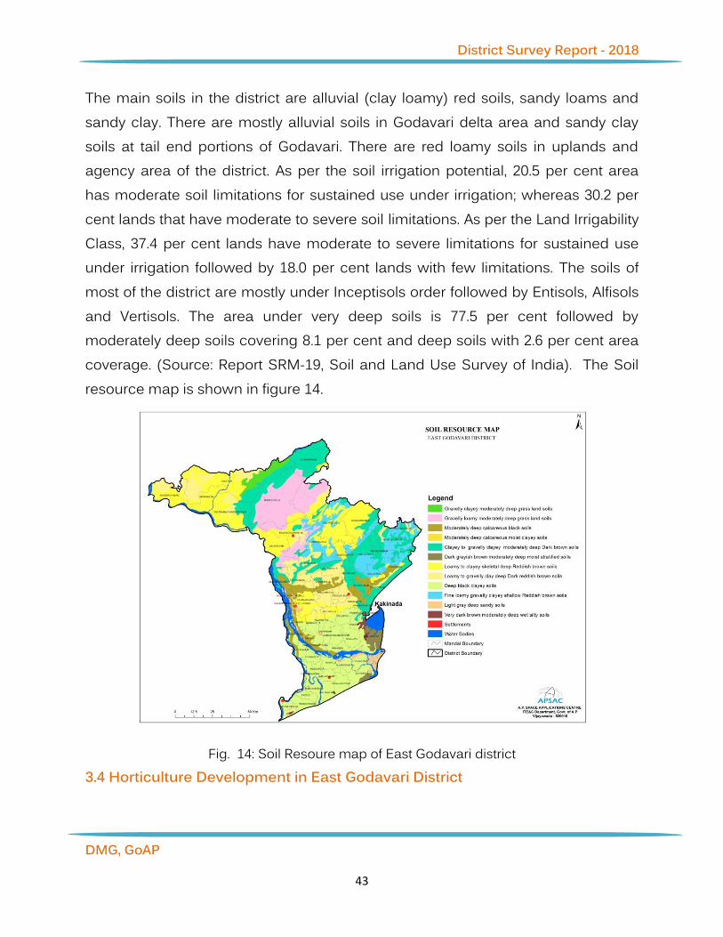
The main soils in the district are alluvial (clay loamy) red soils, sandy loams and sandy clay. There are mostly alluvial soils in Godavari delta area and sandy clay soils at tail end portions of Godavari. There are red loamy soils in uplands and agency area of the district. As per the soil irrigation potential, 20.5 per cent area has moderate soil limitations for sustained use under irrigation; whereas 30.2 per cent lands that have moderate to severe soil limitations. As per the Land Irrigability Class, 37.4 per cent lands have moderate to severe limitations for sustained use under irrigation followed by 18.0 per cent lands with few limitations. The soils of most of the district are mostly under Inceptisols order followed by Entisols, Alfisols and Vertisols. The area under very deep soils is 77.5 per cent followed by moderately deep soils covering 8.1 per cent and deep soils with 2.6 per cent area coverage. (Source: Report SRM-19, Soil and Land Use Survey of India). The Soil resource map is shown in figure 14.
Fig. 14: Soil Resoure map of East Godavari district 3.4 Horticulture Development in East Godavari District

District Survey Report - 2018
DMG, GoAP
44
In Andhra Pradesh, several horticultural crops are grown on a commercial scale in all the three regions and provide livelihood to millions of farmers in the state. Horticulture contributes to about 4 per cent of the state GDP. Horticultural crops cover 13% of the gross area in the state. The area under Horticulture is 19.06 lakh ha. with an annual production of 191.42 lakh tonnes. Andhra Pradesh with high geographical diversity, 9 agro-climatic zones, varied soil types and good irrigation resources is better placed in the production of various horticultural crops such as fruits (8.18 lakh ha; 104.95 MT), vegetables (2.51 lakh ha; 42.1 MT), plantation crops (3.48 lakh ha; 3.5 MT), spices (3.36 lakh ha; 11.8 MT), flowers (0.21 lakh ha; 1.16 MT) and medicinal and aromatic plants (0.09 lakh ha; 0.13 MT). Andhra Pradesh ranks first in the production of mango, chillies, turmeric, sweet orange and papaya. Coconut, oil palm and cashew are important plantation crops. Mango, sweet orange and banana are the leading fruit crops of Andhra Pradesh and accounts for over 86% of the area under fruit crops and over 77% of the total production. Tomato, brinjal and bhendi are the major vegetables grown in the state. Among the spices, Andhra Pradesh ranks first in area and production of chillies and turmeric. Rose, jasmine, crossandra, chrysanthemum, marigold, tuberose are the traditional flower crops of the state.
The Horticultural Department of Government of Andhra Pradesh has launched upon several programmes of development of horticulture, some of which are quite innovative: programmes for cultivation of pineapple as an inter crop in coconut orchards, mushroom cultivation; bee keeping suitable in upland agency areas in the district, and growth of non traditional plantations viz., Amla, Drumstick, Soapnut etc. Efforts are also made for the establishment of nutritional gardens in rural areas in the recent times. It is reported that 5091 beneficiaries are covered under this scheme so for. East Godavari district is a leader in Andhra Pradesh State in the matter of development of horticulture and growth of horticultural produce. With this rich horticultural wealth, there is immense potential for the development of agro based industries in the district.
District Survey Report - 2018
DMG, GoAP
45
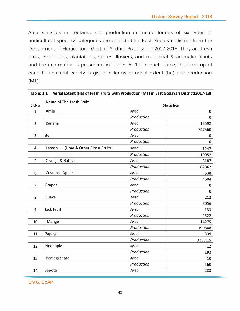
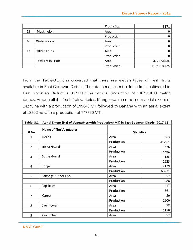
Area statistics in hectares and production in metric tonnes of six types of horticultural species/ categories are collected for East Godavari District from the Department of Horticulture, Govt. of Andhra Pradesh for 2017-2018. They are fresh fruits, vegetables, plantations, spices, flowers, and medicinal & aromatic plants and the information is presented in Tables 5 -10. In each Table, the breakup of each horticultural variety is given in terms of aerial extent (ha) and production (MT).
Table: 3.1 Aerial Extent (Ha) of Fresh Fruits with Production (MT) in East Godavari District(2017-18)
Sl.No Name of The Fresh Fruit
Statistics
1 Amla Area 0
Production 0
2 Banana Area 13592
Production 747560
3 Ber Area 0
Production 0
4 Lemon (Lime & Other Citrus Fruits) Area 1247
Production 19952
5 Orange & Batavia Area 3187
Production 82862
6 Custered Apple Area 538
Production 4604
7 Grapes Area 0
Production 0
8 Guava Area 212
Production 8056
9 Jack Fruit Area 133
Production 4522
10 Mango Area 14275
Production 199848
11 Papaya Area 339
Production 33391.5
12 Pineapple Area 12
Production 192
13 Pomegranate Area 10
Production 160
14 Sapota Area 233
District Survey Report - 2018
DMG, GoAP
46
Production 3171
15 Muskmelon Area 0
Production 0
16 Watermelon Area 0
Production 0
17 Other Fruits Area 0
Production 0
Total Fresh Fruits Area 33777.8425
Production 1104318.425
From the Table-3.1, it is observed that there are eleven types of fresh fruits available in East Godavari District. The total aerial extent of fresh fruits cultivated in East Godavari District is 33777.84 ha with a production of 1104318.43 metric tonnes. Among all the fresh fruit varieties, Mango has the maximum aerial extent of 14275 ha with a production of 199848 MT followed by Banana with an aerial extent of 13592 ha with a production of 747560 MT.
Table: 3.2 Aerial Extent (Ha) of Vegetables with Production (MT) in East Godavari District(2017-18)
Sl.No Name of The Vegetables
Statistics
1 Beans Area 263
Production 4129.1
2 Bitter Guard Area 326
Production 5868
3 Bottle Gourd Area 125
Production 2625
4 Brinjal Area 2129
Production 63231
5 Cabbage & Knol-Khol Area 52
Production 988
6 Capsicum Area 17
Production 561
7 Carrot Area 80
Production 1600
8 Cauliflower Area 78
Production 1170
9 Cucumber Area 52

District Survey Report - 2018
DMG, GoAP
47
Production 1300
10 Chillies Green Area 719
Production 20132
11 Garlic Area 0
Production 0
12 Elephant Foot Yam Area 257
Production 1542
13 Bhendi Area 1087
Production 18479
14 Onion Area 10
Production 250
15 Parwal / Ponted Gourd Area 646
Production 24593
16 Peas Area 740
Production 8876
17 Potato Area 0
Production 0
18 Radish Area 80
Production 1440
19 Pumpkin Area 41
Production 861
20 Sweet Potato Area 5
Production 150
21 Tapioca Area 13639
Production 259141
22 Tomato Area 470
Production 21150
23 Other Vegetables Area 3353
Production 80472
Total Vegetables Area 24169
Production 518558.4
From the Table-3.2, it is observed that there are 21 varieties of vegetables grown in East Godavari District. The total aerial extent of vegetables cultivated in East Godavari District is 24169 ha with a production of 518558.4 metric tonnes. Among all the vegetable varieties, Tapioca has the maximum aerial extent of 13639 ha

District Survey Report - 2018
DMG, GoAP
48
with a production of 259141 MT followed by Brinjal with an aerial extent of 2129 ha with a production of 63231MT.
Table: 3.3 Aerial Extent (Ha) of Plantation with Production (MT) in East Godavari District(2017-18)
Sl.No Name of The Plantation
Statistics
1 Arecanut Area 191
Production 382
2 Cashew Area 30351
Production 33083
3 Cocoa Area 5920
Production 4999
4 Coconut Area 55501
Production 7242
5 Oilpalm Area 30912
Production 587328
6 Coffee Area 0
Production 0
Total Plantations Area 122875
Production 625791.438
From the Table-3.3, it is observed that there are 5 varieties of plantations grown in East Godavari District. The total aerial extent of plantations cultivated in East Godavari District is 122875 ha with a production of 625791.4 metric tonnes. Among all the plantation varieties, Oilpalm has the maximum aerial extent of 30912 ha with a production of 587328 MT followed by Coconut with an aerial extent of Cashew ha with a production of 33083 MT.
Table:3.4 Aerial Extent (Ha) of Spices with Production (MT) in East Godavari District(2017-18)
Sl.No Name of The Spices Statistics
1 Ajwan Area 0
Production 0
2 Betelvine Area 224
Production 3819648
3 Pepper Area 0

District Survey Report - 2018
DMG, GoAP
49
Production 0
4 Chillies (Dried) Area 2893
Production 17356.5
5 Coriander Area 63
Production 126
6 Ginger Area 16
Production 144
7 Tamarind Area 0
Production 0
8 Turmeric Area 558
Production 6138
9 Others Spices Area 39
Production 273
Total (Spices) Area 3793
Production 3849946.5
From the Table-3.4, it is observed that there are 6 varieties of spices grown in East Godavari District. The total aerial extent of spices cultivated in East Godavari District is 3793 ha with a production of 3849946.5 metric tonnes. Among all the spices varieties, Chillies (Dried) has the maximum aerial extent of 2893 ha with a production of 17356.5 MT followed by Turmeric with an aerial extent of 558 ha with a production of 6138 MT.
Table: 3.5 Aerial Extent (Ha) of Flowerswith Production (MT) in East Godavari District(2017-18)
Sl.No Name of The Flowers Statistics
1 Chrysanthemum Area 287
Production 5740
2 Jasmine Area 121
Production 762
3 Marigold Area 162
Production 1782
4 Rose (Lakhs. Of Flowers) Area 22
Production 132
5 Tuberose Area 198
Production 2376
6 Crossandra Area 109
Production 360

District Survey Report - 2018
DMG, GoAP
50
7 Other Flowers Area 68
Production 612
8 Total Flowers Area 967
Production 11632
From the Table-3.5, it is observed that there are 7 varieties of flowers grown in East Godavari District. The total aerial extent of flowers cultivated in East Godavari District is 967 ha with a production of 11632 metric tonnes. Among all the flower varieties, Chrysanthemum has the maximum aerial extent of 287 ha with a production of 5740 MT followed by Tuberose with an aerial extent of 198 ha with a production of 2376 MT.
4. Coastal and Aquaculture Scenario of East Godavari
4.1 Shoreline Change Status of East Godavari District The district of East Godavari, which is located in the Eastern Ghats, is a part of the old Godavari district. The district is also called as “Konaseema” because it is the cradle of coconut plantation in Andhra Pradesh. Two main branches of the Godavari pass through the district to join the Bay of Bengal. The headquarters of

District Survey Report - 2018
DMG, GoAP
51
the district is Kakinada. The East Godavari district lies on the North East coast of Andhra Pradesh. It is bounded by the Visakhapatnam district and the state of Orissa in the north; in the east and south by the Bay of Bengal; and Khammam and West Godavari districts in the west. East Godavari is located between the northern latitudes of 16°30 and 18° and between the eastern latitudes of 80°31 and 82°30. The Climate is comparatively moderate throughout the year except during the months of April to June when the temperature reaches a maximum of 48 deg. Centigrade. The normal rainfall of the district is 1280.0 mm. More than half of the rainfall is brought by South-West Monsoon while a large portion of the rest of the district receives rainfall from the North-East Monsoon also, during October and November. The shoreline change estimation was carried out for entire East Godavari coast which is about 200.35 km in length. In this study, shorelines were extracted from satellite images for 1989, 1999, 2005, 2010 and 2012 by visual interpretation. Shoreline changes are presented with an emphasis on shoreline erosion, because it is an important natural coastal risk along coastal wetlands. The analysis of Table: 4.1 discovered that about 43.97% of the coastlines were under accretion, whereas 40.39% region was experiencing varying erosion and the 15.64% of the coast has stable form. While near Southside of Kakinada port and north portion of Vasishta river area is noticed with high accretion and near North side of Kakinada port area has more erosion areas are found.
Table:4.1 Shoreline Characteristics and statics for East Godavari Coast
Classification of Coast Extent (km) Percentage of Coast Cumulative (%)
High Erosion 36.45 18.19 Medium Erosion 20.94 10.45 Low Erosion 23.54 11.75 40.39 High Accretion 61.14 30.52
Medium Accretion 17.53 8.75
Low Accretion 9.42 4.70 43.97

District Survey Report - 2018
DMG, GoAP
52
Stable Coast 31.33 15.64 15.64 Number of port/Harbour 1
Length of Breakwater ‘ / Groyne /Seawall
4.11
Length of coastline Including River Mouth and Ports
200.35

District Survey Report - 2018
DMG, GoAP
53
Fig. 15 Status of shoreline change in East Godavari district

District Survey Report - 2018
DMG, GoAP
54
4.2 Aquaculture in East Godavari District Nine percent of aqua area of Andhra Pradesh has been distributed in East Godavari district along Vasishta Godavari, Vainateyam Godavari, Gautami Godavari, Gaderu River, Bandaru Kaluva, Kunavaram Drain, Nimmakayala Kottapalli Channel, Vasalatippa Drain, Lower Kausika Drain, Samantakurru Channel, Gundipudi Channel, Adivipalem Branch Channel, Gudimula Channel and other small rivers, streams, drains and Canals. In East Godavari, 15,533 ha Aquaculture, 7763 ha Abandoned/dry/Potential, 27 ha Saltpans and 23,324 ha total aqua area is distributed. In East Godavari district, the highest aquaculture area is distributed in Uppalaguptam Mandal i.e 2,629 ha aquaculture, 964 ha Abandoned/dry/Potential and total 3,593 ha area is distributed and least is in Ambajipeta mandal 2 ha, Samalkota 5 ha, Rayavaram 6 ha aquaculture and Abandoned/dry/Potential area has been distributed. (Fig.16)

District Survey Report - 2018
DMG, GoAP
55
Fig. 16 Aquaculture distribution in East Godavari district
Table.4.2 Mandal - wise Aquaculture distribution in East Godavari district

District Survey Report - 2018
DMG, GoAP
56
5 Water Resources in East Godavari District
Mandal - wise Aquaculture in East Godavari (Area in ha) Sno
Mandal Name Aquaculture
Dry/Abandoned
/Potential
Saltpans
Total 1 Ainavilli 69 11 79 2 Allavaram 2122 531 2653 3 Amalapuram 191 32 223 4 Ambajipeta 2 0 2 5 Atreyapuram 72 0 72 6 I. Polavaram 1114 146 1260 7 Kajuluru 567 95 662 8 Kakinada (Fully Urban)
(M) 39 5 44
9 Kakinada (Rural) 19 0 19 10 Karapa 416 0 416 11 Katrenikona 2124 1792 27 3944 12 Kothapalle 153 125 278 13 Malikipuram 361 324 685 14 Mamidikuduru 409 412 821 15 Mummidivaram 379 89 467 16 P.Gannavaram 51 0 51 17 Pedapudi 235 0 235 18 Ramachandrapuram 134 0 134 19 Rayavaram 6 0 6 20 Razole 414 109 523 21 Sakhinetipalle 1456 1960 3416 22 Samalkota 5 0 5 23 Thallarevu 2443 1001 3444 24 Thondangi 114 169 284 25 Tuni 7 0 7 26 Uppalaguptam 2629 967 3596
Total 15,534 7,764 28 23,325

District Survey Report - 2018
DMG, GoAP
57
5.1 Surface Water Resources of East Godavari district Andhra Pradesh state is rich in water resources. River Godavari is the largest and broadest river in the southern India, which originates at Triambakeshwar near Nasik in Maharashtra. The Delta coastal line in the district is around 150 Kms in the Eastern sea board of India with minor ports at Kakinada and Odalarevu. The details of major and medium projects of East Godavari district are as follows:
5.1.1 Major and Medium Irrigation Projects in East Godavari district Irrigation has assumed an increasing significance in agriculture in the context of new technology, where high yielding varieties and multiple cropping is being practiced. The main reasons for low yields are inadequate rainfall, uneven and uncertain rains during the period of crop growth. It is generally found that the introduction of irrigation is associated with changes in the cropping pattern. The shift from traditional cropping pattern to the most advantageous cropping pattern is possible only in the presence of irrigation facilities. The new agricultural technology is highly based on sufficient moisture conditions. Thus, the development of irrigation is crucial for increasing agricultural production. The irrigation projects are classified as major, medium and minor irrigation projects.
5.1.2 Major Irrigation Project The major irrigation projects covering East Godavari district are Godavari Eastern Delta. The district is enriched by huge water resources of River Godavari and major streams like Yeleru, Suddagedda, Pampa and Thandava. The Delta coastal line is around 150 Kms in the Eastern sea board of India with minor ports at Kakinada and Odalarevu. Sir Arthur Cotton Barrage has an extent of 483199 acres and Yeluru reservoir project an extent of 53017 acres, Thandava reservoir project with an extent of 16947 acres and Chagalnadu L.I. Scheme an extent of 22846 acres are the major projects of East Godavari districts (Fig. 17). The overall coverage under major irrigation project is 5,76,009 acres. The major ongoing irrigation project is Polavaram project. Under this ongoing project, about 71,000

District Survey Report - 2018
DMG, GoAP
58
acres are covered and second major ongoing project is Venkatnagaram Lift Irrigation project under which anthe area about 24,000 acres are covered.
Fig. 17 Major and Medium Irrigation Projects of East Godavari District
5.1.3 Medium Irrigation Project The Medium Irrigation projects are Pampa reservoir Project, Subbareddy Sagar project, Torrigedda pumping scheme and K.V. Ramakrishna Surampalem reservoir Project. These medium irrigation projects fall under eight assembly

District Survey Report - 2018
DMG, GoAP
59
segments with an ayacut of 49,792 acres. The medium ongoing projects are Bhupathipalem reservoir project, Musurumilli reservoir project and Maddigedda reservoir project. These medium irrigation projects fall under four assembly segments with an ayacut of 42,868 acres. 5.1.4 Tank Information System
Andhra Pradesh Space Application centre developed Web Portal GIS for Tank Information System (TIS) in Andhra Pradesh. In the web portal, minor irrigation tanks are classified as more than 40 ha, 10 to 40 ha and less than 10 ha command. Information pertaining to nearly 15,000 tanks in Andhra Pradesh has been published in APSAC website , while information related to 454 tanks of East Godavari district has been published in the said website so far. The tank-wise information presents the location details, hydrological details and other standard information related to the tank. The details are shown in website. http://apsac.ap.gov.in:8090/tis/index.html
5.2 Ground Water Scenario and Quality of the District 5.2.1 Geomorphology of the District Geomorphologically, the district is divisible into (1) a low lying deltaic and coastal plain, having a gentle easterly slope in the south, (2) a sediplain region with mesas, structural hills, pediment, and piedmont complex, comprising valley fins, taluscones and fans in the middle and pediment I pediplain complex, with structural and denudational hills in the north. The deltaic plain shows a relief between 15m, at its apex to 2m, near the coast. The upland plain (plateau) of Rajahmundry Formation rises to a height of 45m to 70m, near Rajahmundy. The deltaic and coastal plains are characterised by landforms of both fluvial and marine regimes. Amongst the fluvial landforms, active channel (Gautami Godavari and Vasistha Godavari) with associated braided/ channel bars and levees form a part of the sub-aerial top-set beds of the delta. Of all the levees, the one developed near Dowleswaram, 500mwide, 2m high over the ambient flood plain is worth

District Survey Report - 2018
DMG, GoAP
60
noting. Using IRS satellite data and GIS detailed geomorphological and structural map of Krishna District was generated as per Rajiv Gandhi National Drinking Water Mission (RGNDWM) guidelines on 1:50,000 scale. The objective of this mapping is to map lithology, geomorphology and structural characteristics of an area on 1:50,000 scale and to integrate the same to locate potential ground water prospect zones and to recommend suitable structures for ground water recharge. Various hydrogeomorphic units are delineated and suitable recharge structures are proposed at drinking water affected villages under this project. The description of geomorphic units of different origins (Fig.18) mapped in East Godavari District are described below.
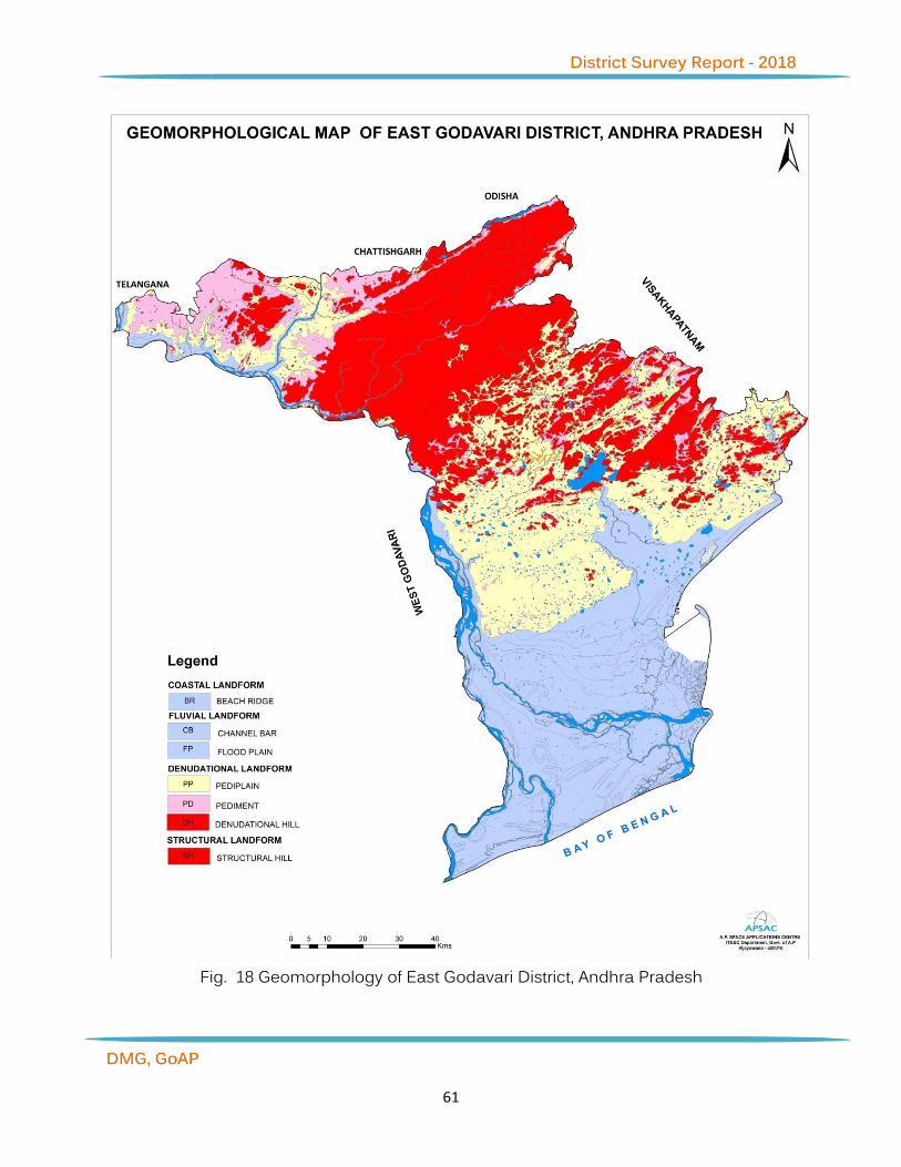
District Survey Report - 2018
DMG, GoAP
61
Fig. 18 Geomorphology of East Godavari District, Andhra Pradesh

District Survey Report - 2018
DMG, GoAP
62
5.2.2 Landforms of fluvial origin The word fluvial is used in Earth science to refer to the processes and landforms produced by running water. As with other surficial processes, running water can either erode material from the earth’s landscape, or deposit layers of sediment. The resulting landforms can thus be classified as either erosional landforms or depositional landforms. The incredible power of running water in carving various erosional and depositional landforms is well known. Although the quantity of water in stream is small at one time during the course of the year, very large volumes of water move through the channel and they form an important component in the hydrological cycle. The fluvial dissection of the landscape consists of valleys and their included channel ways organized into a system of connection known as a drainage network. Drainage networks display many types of quantitative regularity that are useful in analyzing both the fluvial systems and the terrains that they dissect (NRSA, 2007). Alluvial plain: A level or gently sloping tract or a slightly undulating land surface produced by extensive deposition of alluvium, usually adjacent to a river that periodically overflows its banks; it may be situated on a flood plain, a delta, or alluvial fan. This landform is predominantly seen on the southern part of the District. Palaeochannel: Deep valleys cut in the bedrock terrain and today filled largely with alluvium, glacial outwash gravels and sands or with tills. These are good source for underground water. Flood plain: The surface or strip of relatively smooth land adjacent to a river channel constructed (or in the process of being constructed) by the present river in its existing regimen and covered with water when the river overflows its banks at times of high water. It is built of alluvium carried by the river during floods and deposited in the sluggish water beyond the influence of the swiftest current. Delta: The low, nearly flat, alluvial tract of land deposited at or near the mouth of a river, commonly forming a triangular or fan shaped plain of considerable area

District Survey Report - 2018
DMG, GoAP
63
enclosed and crossed by many distributaries of the main river, perhaps extending beyond the general trend of the coast, and resulting from the accumulation in a wider body of water (usually a sea) of sediment supplied by a river in such quantities that it is not removed by tides, waves and currents. Valley fills: The unconsolidated sediment deposited by any agent so as to fill or partly fill a valley. 5.2.3 Landforms of coastal origin Coasts are also the loci of a unique assemblage of erosional and depositional processes. The various landforms of coastal areas are almost exclusively the result of the action of ocean waves. Wave action creates some of the world’s most spectacular erosional landforms. Where wave energy is reduced, depositional landforms like beaches are created. The source of energy for coastal erosion and sediment transport is wave action. A wave possesses potential energy as a result of its position above the wave trough, and kinetic energy caused by the motion of the water within the wave. This wave energy is generated by the frictional effect of winds moving over the ocean surface. Higher the wind speed and the longer the fetch or distance of open water across which the wind blows and waves travel, larger the waves and the more energy they, therefore, possess. Long open ocean waves or swells travel faster than short, locally generated sea waves. They also have longer wave periods and this is how they are distinguished from the short sea waves on reaching the coast. Long swells, which have travelled hundreds of kilometers, may have wave periods of up to 20 seconds. Smaller sea waves have wave periods of 5 to 8 seconds. Where ocean depths are greater than the length of the waves, the wave motion does not extend to the ocean floor and therefore remains unaffected by the floor. As the ocean depth falls below half the wavelength, the bottom increasingly affects the wave motion. As the depth of water decreases, the wave height increases rapidly and the wavelength decreases rapidly. Thus, the wave becomes more and more peaked as it approaches the shore, finally curling over as a breaker and breaking on the shore.

District Survey Report - 2018
DMG, GoAP
64
As the wave breaks, its potential energy is converted into kinetic energy, providing a large amount of energy for the wave to do work along the shoreline. Transportation by waves and currents is necessary in order to move rock particles eroded from one part of a coastline to a place of deposition elsewhere. One of the most important transport mechanisms results from wave refraction. Since waves rarely break onto a shore at right angles, the upward movement of water onto the beach (swash) occurs at an oblique angle. However, the return of water (backwash) is at right angles to the beach, resulting in the net movement of beach material laterally. This movement is known as beach drift. The endless cycle of swash and backwash and resulting beach drift can be observed on all beaches. Frequently, backwash and rip currents cannot remove water from the shore zone as fast as it is piled up there by waves. As a result, there is a build up of water that results in the lateral movement of water and sediment just offshore in a direction with the waves. The currents produced by the lateral movement of water are known as long shore currents. The movement of sediment is known as long shore drift, which is distinct from the beach drift described earlier, which operates on land at the beach. The combined movement of sediment via long shore drift and beach drift is known as littoral drift. Tidal currents along coasts can also be effective in moving eroded material. While incoming and outgoing tides produce currents in opposite directions on a daily basis, the current in one direction is usually stronger than the other resulting in a net one-way transport of sediment. Long shore drift, long shore currents, and tidal currents in combination determine the net direction of sediment transport and areas of deposition. Using multi-temporal satellite data can bring out the dynamics of the coast (NRSA, 2007). Beach: A gently sloping zone, typically with a concave profile, of unconsolidated material that extends landward from the low-water line to the place where there is a definite change in material or physiographic form (such as a cliff) or to the line of permanent vegetation (usually of the effective limit of the highest storm waves). Beach ridge: A low, essentially continuous mound of beach or beach and dune material (sand, gravel, shingle) heaped up by the action of waves and currents on

District Survey Report - 2018
DMG, GoAP
65
the backshore of a beach beyond the present limit of storm waves or the reach of ordinary tides, and occurring singly or as one of a series of approximately parallel deposits. The ridges are roughly parallel to the shoreline and represent successive positions of an advancing shoreline. Coastal plain: A low, generally broad but sometimes narrow plain that has its margin on the shore of a large body of water (esp. the ocean) and its strata either horizontal or very gently sloping toward the water, and that generally represents a strip of recently emerged sea floor or continental shelf. Dune and Swale complex: It is a large complex of parallel wetland swales and upland beach ridges (dunes) found in coastal embayment and on large sand spits along the shorelines of the Great Lakes. The upland dune ridges are typically forested, while the low swales support a variety of herbaceous or forested wetland types, with open wetlands more common near the shoreline and forested wetlands more prevalent far from the lake. Tidal flat: An extensive, nearly horizontal, marshy or barren tract of land that is alternately covered and uncovered by the rise and fall of the tide, and consisting of unconsolidated sediment (mostly mud and sand). It may form the top surface of a deltaic deposit. 5.2.4 Landforms of Structural Origin Landform of structural origin is related to structural aspect of the area. Most of the landforms under this class have genesis related to underlying structure. Structure plays an important role in reducing the resistance of rock which manifests itself in different geomorphic forms. Some of the variations in minor and some are in mega scale. The mega scale forms have a dramatic effect on the genesis of landforms and hence mapping of such forms indirectly indicates the structural set up of the area. The mega scale structural features like fault and fold depending on

District Survey Report - 2018
DMG, GoAP
66
its type plays an important role in genesis of structural landform. The influence of geologic structures on the development and appearance of landscapes is prominent. The influence of geologic structures ranges from large features, which exert a dominant influence on the form of an entire landscape, to small features, which affect an individual landform and the geomorphic processes operating on it. The structural control could be active structures whose form is directly impressed on the modern landscape or ancient structural features whose influence on a modern landscape is due primarily to differential erosion (NRSA, 2007). Dome: A general term for any dome shaped landform or rock mass, such as a smoothly rounded rock-capped mountain summit, roughly resembling the dome of a building. Structural Hills: Hills and valleys, which are originated due to tectonic process and are highly dissected by the drainage lines. This can be further classified as highly, moderately and low dissection depending on the density of joints and drainage. Mostly, this will be interpreted from a planimetric satellite data and the classification is highly subjective. Dyke Ridge: Intrusive features that are emplaced within the pre-existing fractures or where the fluid pressure is great enough for them to form their own fracture during emplacements. They are discordant bodies. Cuesta: A hill or ridge with a gentle slope on one side and a steep slope on the other; specifically an asymmetric ridge with one face (dip slope) long and gentle and conforming with the dip of the resistant bed or beds that form it, and the opposite face (scarp slope) steep or even cliff-like and formed by the out crop of the resistant rocks, the formation of the ridge being controlled by the differential erosion of the gently inclined strata. 5.2.5 Landforms of denudational origin Landform of denudational origin is formed where the denudation process dominates over the other process. Most of the landforms resulting due to this process is the combined effect of mechanical and chemical weathering.

District Survey Report - 2018
DMG, GoAP
67
Denudation is the process of removal of material by erosion and weathering. This has direct influence on the relief of the area especially in the reduction of relief to the base level. The agents are mostly water, ice and wind. The major factors affecting denudation are geology, climate, tectonics and anthropogenic effects. All rocks and minerals at or near surface are attacked by physical and chemical process. The effect of this process is not same everywhere because of rocks varying resistance to change. As a result, weathering and erosion yield number of landforms, which have typical shape and forms. Weathering is an essential part of the rock cycle. The parent material, or rock weathered material is disaggregated to form smaller fragments and some of the minerals are dissolved and removed by the agent of water. This removal of material is erosion and is accomplished by running water, wind, glacier etc. The weathering provides a raw material for the sedimentary rock and soil (NRSA, 2007). Denudational Hill: It is a highly dissected hill which has obliterated the structures. Inselberg: A prominent, isolated, steep sided, usually smoothed and rounded, residual knob, hill or small mountain of circumdenudation rising abruptly and surrounded by an extensive and nearly level, lowland erosion surface in a hot, dry region (as in the deserts of southern Africa or Arabia), generally bare and rocky although partly buried by the debris derived from and overlapping its slopes; it is characteristic of an arid or semiarid landscape in a late stage of the erosion cycle. Pediment: A broad, flat or gently sloping, rock floored erosion surface or plain of low relief, typically developed by sub aerial agents (including running water) in an arid or semiarid region at the base of an abrupt and receding mountain front or plateau escarpment, and underlain by bedrock (occasionally by older alluvial deposits) that may be bare but more often partly mantled with a discontinuous veneer of alluvium derived from the upland masses and in transit across the surface. Pediment-Inselberg Complex: The pediments dotted by numerous inselbergs of small sizes, which make it difficult to distinguish from the pediments. Hence, it is called a complex of pediment and inselberg.

District Survey Report - 2018
DMG, GoAP
68
Pediplain: An extensive, a multi-concave, rock cut erosion surface formed by the coalescence of two or more adjacent pediments and occasional desert domes, and representing the end result (the “peneplain”) of the mature stage of the erosion cycle. Based on the thickness of weathering, they are further classified as shallow, moderate and deep pediplains. Residual Hill: A small remnant hill, which has witnessed all forms of denudation. 5.3 Structural Features of East Godavari District East Godavari District has consolidated formations which include crystallines (Khondalites, Charnockites and granitic gneisses) and Meta sediments (Dolomites, shales, phyllites and quartzites) of Archaean and Pre-cambrian periods, respectively. The Khondalite Group of rocks are seen as prominent hill ranges (strike ridges) south of Vijayawada city, extending towards north and northeast. The rocks of Khondalite, Charnockite groups and the layered complex show foliation trending dominantly N-S with local swerves to NE-SW and NW-SE (GSI, 2000). The semi consolidated formations are represented by Tertiary formations (Rajahmundry & Gollapalli sandstones) and unconsolidated formations comprise deltaic alluvial deposits of Quaternary period (CGWB, 2013). The structural map (Fig.19) of East Godavari District is given below:

District Survey Report - 2018
DMG, GoAP
69
Fig. 19 Structural Map of East Godavari District, Andhra Pradesh

District Survey Report - 2018
DMG, GoAP
70
5.4 Ground Water Prospects in the District
Fig. 20 Ground Water Scenario in East Godavari District, Andhra Pradesh
Ground water occurs in all most all geological formations and its potential depends upon the nature of geological formations, geographical setup, and incidence of rainfall, recharge and other hydrogeological characters of the aquifer. In consolidated formations, ground water occurs under unconfined to semi-confined conditions. Ground water is developed in these formations by dug wells, dug cum bore wells and bore wells tapping weathered and fractured zones. The yields are in the range of 20 to 70 m3/day. The occurrence of fractures in the

District Survey Report - 2018
DMG, GoAP
71
crystalline formations is limited down to 30 to 40 m bgl and occasionally extends down to 70 - 100 m bgl. The bore wells constructed in the crystalline formations generally tap the weathered and fractured zones. The yields of the bore wells generally range between 80 and 400 m3/day. The higher yields are limited to the available thickness of fractured and jointed zones. In the meta sediments, the yields are very limited and are in the range of 10 to 80 m3/day. Higher yields occur in limestone formations. Ground water in semi-consolidated formations occurs under unconfined to confined conditions. Ground water is developed in these formations by dug cum tube wells and tube wells. These formations are potential aquifers. The yields of the dug cum tube wells are in the range of 30 to 45 m3/day. Granularity of the sandstone bed is the deciding factor of the yield potential as the higher yields are recorded in the Rajahmundry sandstones tapping coarse sandstone beds. The yields of the tube wells in Gollapalli sandstones and Rajahmundry sandstones are in the range of 60 to 200 m3/day and 600 to 1500 m3/day, respectively. The deltaic area is underlain by alluvium of recent age consisting of varying proportions of clay, silt, sand and gravel. The thickness of alluvium ranges from few meters to about 600 m followed by tertiary formations. In deltaic area, ground water occurrence is controlled by landforms. In deltaic area also, a lot of heterogeneity in hydrogeological conditions exist both spatially and vertically. Fresh water is generally limited to shallow to moderate depths only, whereas in the southern part of the delta it occurs as pockets and lenses. Deep aquifers are generally saline. Palaeo-channels are favourable locations for fresh water aquifers. Ground water occurs under phreatic to confined conditions and is developed through shallow dug wells, filter point wells and shallow tube wells. The depth of dug wells ranges from about 2 to 7 m, while the depth of filter point wells varies from 5 to 13 m and the depth of tube wells varies from 40 to 80 m. The yields generally range in this aquifer between 250 and 400 m3/day. Occasionally high yields up to 15 lps exist in the palaeo-channels. The transmissivity value of the aquifer in the semi & unconsolidated formations varies from 2.5 to 5560 m2/day. The depth of water levels during pre-monsoon season (May, 2012) in the district

District Survey Report - 2018
DMG, GoAP
72
ranges between 2 and 10 m bgl. The Ground water Department established extensive network of piezometer observation wells throughout Andhra Pradesh and monitoring the ground water levels (Fig.20) and distribution of Piezometer observation well is given in figure 21.
Fig. 21 Distribution of Piezometer Observation wells in East Godavari
5.5 Ground Water Quality of the District The Godavari is the major river drain the district, which is perennial and flows along the western boundary of the district. South of Rajahmundry, the river bifurcates into two viz., Gautami Godavari in the East and Vasista Godavari in the West. The Godavari River further splits into smaller arms before it debouches into the Bay of Bengal. The other important rivers and tributaries of Godavari flowing in the district are Gondiyeru, Pamuleru, and Polavaram vagu, Sileru River, Suddagedda, Yeleru, Madeyeru and Tandava. The general drainage pattern is dendritic to sub-dendritic. The drainage density varies from less than 0.4 km/sq.km in poorly drained alluvial areas which covers the entire southern parts of the

District Survey Report - 2018
DMG, GoAP
73
district to 0.6 km/sq.km in the Northern parts occupied by crystalline rocks. Climate of the District is mainly warm. The District can be divided into four natural agro climatic zones – Central Delta, Eastern Delta, the Uplands and the Agency tracts. The delta lands are formed along the lower drainage basins of the major rivers flowing through the District viz., the Godavari, the Yeleru and the Pampa, where the elevation is usually a few feet above the mean sea level. Ground water samples were collected from 1892 habitations out of 2913 habitations representing two seasons i.e., post monsoon and pre monsoon in December 2012 and June 2014 for the entire District. The water samples were collected from Rural Water Supply and Sanitation Department (RWS & S) and analyzed for physico-chemical parameters like TDS, TH, Cl, NO3, pH, F, Fe, TA and SO4 using standard techniques in the laboratory and compared with the BIS (10500-2015), in terms of desirable, permissible and non potable classes. Blue, yellow and red colours indicate pre monsoon quality and +, - , Symbols indicate post monsoon quality for desirable, permissible and non-potable classes, respectively. From the analysis, it has been observed that the ground water is polluted in pre monsoon and post monsoon as about 55% of the area is under non potable category due to high concentration of Nitrate and Total Hardness. About 20% of the area is potable category remaining 25% of the area is covered in hills and water bodies of the entire District. The occurrence and movement of groundwater in an area is governed by several factors such as topography, lithology, and geological structure, depth of weathering, extent of factures, drainage pattern, and climate conditions and interrelationship between these factors. The ground water quality map of East Godavari district is given in figure 22.

District Survey Report - 2018
DMG, GoAP
74
Fig. 22 Ground Water Quality Map of East Godavari District

District Survey Report - 2018
DMG, GoAP
75
6 Geology and Mineral Resources of the District
6.1 Geology of East Godavari District The northern half of the East Godavari district forms a part of the Eastern Ghats Mobile Belt, exposing all the characteristic litho units of the Eastern Ghats Viz., the Khondalite, Charnockite, and Migmatite groups. The Khondalite group is represented by Quartz, garnetsillimanite gneiss (Khondalite), along with unmappable units of quartzite and calc-granulite/gneiss. Within the Khondalite suite itself, varied mineralogical assemblages like graphite schist, cordierite-silllimanite gneiss, and sapphirine-bearing quartzo-feldspathic gneiss occur. The Charnockite group consists of acidic, intermediate and basic varieties. The Migmatite group includes a host of rock types, like porphyroblastic granitoid gneiss, garnetiferous quartzo-feldspathic gneiss (leptynite), garnet-biotite hypersthene gneiss and quartzo-feldspathic mobilizates. Unconformably resting over the crystalline rocks of Archaean age occur, the uppermost member (Tirupathi Sandstone) of the Gondwana Supergroup, deposited in a transitional environment, along the coast. It consists of coarse grained sandstone with conglomerate and clay zones. Ptylophyllum flora is recorded in the clay zone. Near Annavaram, the Gondwana rocks have yielded marine fauna (Triaonia Sp. lnoceramus Sp.. Pseudomontis Sp., Pecten Sp. and Heiicoceras Sp.,). The Deccan Traps occur, 2 km. north and east of Rajahmundry and extend in ENE-WSW direction. Limestone intertrappeans, rich in Gastropod and Lamellibranch fossils, occur near Kotilingala, Korukonda and Kateru. Rajahmundry Formation, named after the type locality, Rajahmundry, is an ensemble of fine-grained, purple coloured sandstone, grit and conglomerate, overlain by current bedded sandstone with clay and shale bands. Intermittently exposed between Rajahmundry and Samalkot, it is equivalent to Warkalli Beds of Kerala and Cuddalore Formation of Tamil Nadu. The deltaic plain is characterized by fluvial to fluvio-marine and marine deposits of Quaternary age, which are described in detail under geomorphology.

District Survey Report - 2018
DMG, GoAP
76
The Geological Survey of India (GSI, 2000) gave a detailed account of the geology/lithology of the District with a map on 1: 2,50,000 scale (Fig.23) and an elaborate legend with stratigraphic sequence (Fig.24). The description given by GSI is as follows.
Fig. 23 Geology of East Godavari District, Andhra Pradesh

District Survey Report - 2018
DMG, GoAP
77
Fig. 24 Detailed Legend with Stratigraphic Sequence of East Godavari District

District Survey Report - 2018
DMG, GoAP
78
6.2 Mineral Resources of East Godavari District
East Godavari district has very good mineral resources. Graphite, fire day, china day, laterite, and bauxite that are used extensively in several industries are found in the district. There are several mineral-based industries set up in the district already. Mangalore tiles, bricks, graphite crucibles chemical refractories are some of the industries set up with the help of the mineral resources available in the district. Apart from these, road metal, gravel and sand are also available in plenty in the district. East Godavari district has a coastline of 114 kms as stated already. There are 12500 acres of land on this coastline, particularly on the Kakinada and Yanam road, where salt is manufactured. This provides immense potential for the development of salt industries and a number of salt-based chemical industries in the district. The rich deposits of graphite, clay and fire clay and laterite in the district provide immense scope for setting up the pencil grade graphite units; grease, lubricants, electronic goods and ceramic based industries in the district. Oil and Natural Gas Commission already made substantial efforts in the direction of striking oil in Godavari basin of the district. It has already established that plenty of gas is available in the district particularly in the Razole region of Godavari basin. Recent finding of availability of huge deposits of oil and gas in the Godavari basin has catapulted East Godavari district on the national and international scenario because natural gas is going to be the foremost and abundantly available source for power generation and energizing the industrial sector. When these huge deposits of oil and natural gas are fully exploited, the ever-growing problems of power deficiency causing frequent power cuts and load shedding will be solved and the pace of industrial development will be further accelerated.

District Survey Report - 2018
DMG, GoAP
79
7 Details of Major and Minor Minerals-Their Production and Revenue in the District
7.1 Administrative Set-Up of DMG in East Godavari District: The functions of the office of the Asst. Director of Mines and Geology at Rajamahendravaram is promoting Mineral regulatory work and development in East Godavari District within the purview of APMMC Rules, 1966 in case of Minor Mineral and M.C.Rules, 1960 and MM(D&R) Act, 1957 and other rules.
7.2 Overall view of Mining Activity in the District In East Godavari district, Mandal wise minerals distribution given in table 7.1. Table-7.1 Mineral and Place of distribution Mandal-wise Sl. No Mineral Place of distribution Mandal-wise
1 Oil & Gas S.Yanam, Mori, Pasarlapudi, Razole I &II, Tatipaka, Manepalli, Eenamuru, Chintalapalli.
2 Laterite Maredumilli, Prathipadu 3 Fire Clay Rajanagaram & Rajahmundry 4 China Clay Jaggampeta, Gandepalli 5 Road Metal Addateegala, Ganavaram, Gokavaram, Korukonda,
Prathipadu, Rampachodavaram, Seetanagaram, Yeleswaram, Rowthulapudi, Tuni, Rajahmundry & Rajanagaram and Sankavaram
6 Building Stone Kirlampudi, Prathipadu, Tuni 7 Gravel / Earth Anaparthi, Biccavolu, Kadiyam, Karapa, Thondangi,
Rangampeta, Mandapeta, Peddapuram, Samarlakota, Gandepalli, Biccavole etc
8 Granite Rampachodavaram, Addateegala, Yeleswaram, Gangavaram, Rowthulapudi, Sankavaram
Bauxite

District Survey Report - 2018
DMG, GoAP
80
Bauxite is basically an aluminous rock that contains hydrated aluminium oxide as main constituent and Iron oxide, Silica & Titania as minor constituents present in varying proportions. Hydrated aluminium oxides present in the bauxite ore are diaspore and boehmite, Al2O3.H2O (Al2O3-85%; Al-45%); gibbsite or hydrargillite, Al2O3.3H2O (Al2O3- 65.4%; Al-34.6%), and bauxite (containing colloidal alumina hydrogel), Al2O3.2H2O (Al2O3-73.9%; Al-39.1%). Bauxite is the principal ore of aluminium which is one of the most important non-ferrous metals used in the modern industry. It is also an essential ore for Refractory and Chemical industries. In East Godavari District, capping of Laterite which contains at places Bauxite, the raw material for manufacture of Aluminium are found in Dumakonda (V) near Y. Ramavaram. The estimated reserves are about 0.25 million tonnes. Uses: Bauxite is used in a lot of industries like the chemical industry, refractory, abrasive, cement, steel, and petrol industry amongst others. In chemical, bauxite along with alumina is used in the manufacturing of aluminium chemicals. Laterite Laterite is a surface formation that is enriched in iron and aluminium. Found mainly in hot, wet tropical areas, it develops by intensive and long-lasting weathering of the underlying parent rock. The mineralogical & chemical composition of Laterite depends on their parent rock. Due to the presence of iron oxides, lateritic soils are red in colour ranging from light bright to brown shades. The term ‘laterite’ was originally used for highly ferruginous deposits. It is a highly weathered material, rich in secondary oxides of iron, aluminium or both. It is either hard or capable of hardening on exposure to moisture and drying. Laterite and bauxite show a tendency to occur together. Aluminous laterites and ferruginous bauxites are quite common. The most common impurity in both is silica. Laterite gradually passes into bauxite with a decrease in iron oxide and an increase in aluminium oxide. In East Godavari District, Laterite mineral is formed under process of weathering of Khondalite suit of rocks i.e Aluminium rich rocks of Archean Age. The mineral occurs in most of the hill ranges above 300 Mt to 900 Mt of MSL of Khondalite suit of Rocks and distributed mandals of Y.Ramavaram, Vanthada, Chintaluru, Gajjanapudi of Prathipadu(M) and Avelthi, Anumarthi of Sankavaram (M), Pedduru of Rowthulapudi (M). Low grade Laterite capping is found 2 to 4 meters over the Rajahmundry Sand Stone in G.Yerrampalem, Kadiyam, Kesavaram, Biccavolu villages around Rajahmundry. The estimated reserves are about 94.84 million tonnes of an extent of 431.11 Hects out of 33 leases.

District Survey Report - 2018
DMG, GoAP
81
Uses: Laterite is a soil and rock type rich in iron and aluminum, and is commonly considered to have formed in hot and wet tropical areas. Historically, laterite was cut into brick-like shapes and used in monument-building.
Fig. 25 Laterite specimen in East Godavari District
Fig. 26 Mining Operations in Vanthada village, East Godavari
Colour Granite Colour Granite genetically occurs in Eastern Ghats Mobile Belt of Charnokite suit of Rocs and composed of mineral constituents mineral Garnet – Ferrous Gneisses granites of Archean age. These Colour Granites formed Granulite phases of Migmatization. In East Godavari District, the colour granite type is Leptynites. Leptynites composed of Garnet – Quartzo-Feldspathic gneiss and Megmatized

District Survey Report - 2018
DMG, GoAP
82
charnokites and the trade name is “Kashmir White”. In East Godavari District, the Colour Granite quarries are located in Rowthulapudi, Gangavaram and Rampachodavaram Mandals. Uses: These rocks are useful for cutting and polishing, and as decorative monuments.
Fig. 27 Leptynite Granite Block in Nellipudi village, East Godavari
Fig. 28 Granite Systematic in Nellipudi village, East Godavari Quartz Geologically, the occurrence of Quartz in the district as intrusive belongs to Peninsular Gneissic Complex of Archaean Age. The vein deposit of the quartz in the district observes in association with two litho units viz. (1) Quartz vein with Feldspar

District Survey Report - 2018
DMG, GoAP
83
as Hanging wall and (2) quartz vein with muscovite schist. The quartz body is generally covered by the soil and Feldspar in the lower altitudes i.e. on either side of the Quartz vein. The Quartz is massive, glassy in nature. It is colour-less to translucent. General strike of the Quartz vein is NW-SE. Feldspar occurs as a hanging wall over the exposed Quartz Bodies. Quartz, quartzite and silica sand are used in various industries like glass, refractory, foundry, ceramic, cosmetic, electrical, abrasives, paints, etc. The primary use of silica is in the manufacture of virtually all types of glassware, ceramics and ceramic glazes. Other major uses are in metallurgy, (where silica is used as a refractory, foundry mould, fluxes and as a source of silicon for the production of silicon metal and ferro-silicon and other ferro-alloys), silicon carbide manufacture, chemical & construction sectors, and as a natural abrasive. Known for its piezoelectric properties, high quality quartz crystal is used in electronic devices, multiple telephone lines, depth-sounding devices, range finders, chronometers, etc. In East Godavari District, the Quartz quarries located in Chintoor, Vara Ramachandrapuram and Yetapaka Mandals (Fig 29).
Fig. 29 Quartz at Chintoor village, East Godavari District
Fire Clay The name fireclay is given to a group of refractory clays which can withstand temperatures above pyrometric cone equivalent (PCE) - 19. Refractoriness and plasticity are the two main properties needed in fireclay for its suitability in the manufacture of refractory bricks. A good fireclay should have a high fusion point
Uses: The available Quartz mineral in the district is semi glass quartz and milky quartz variety and is used in Ceramic-tile manufacturing industry. Fine powder of the Quartz is widely used in the paint industry and glass industry.

District Survey Report - 2018
DMG, GoAP
84
(>1580o C) and good plasticity. Fireclay containing high alumina and low iron oxide, lime, magnesia & alkalies is preferred by refractory manufacturers. The aluminous (kaolinitic) variety of fireclay is more refractory because of its hardness and density and absence of iron, giving it a white burning colour. The absence of alkalies gives it a very high fusion temperature. Fireclays are used in the manufacture of cement, bricks, blocks, retorts, crucibles, mortars, masses, pottery, floor tiles, etc. Low-grade material is used for manufacturing heavy sanitary-ware, such as, pipes and bath tubs. Firebricks are used where heat generation is involved. Firebricks are used extensively in furnaces, kilns and ovens. Firebricks are required chiefly by metallurgical industries. In East Godavari District, the Fire Clay quarries are located in Rajamahendravaram Rural, Rajanagaram and Kadiyam Mandals.
Fig. 30 Fire Clay Specimen in East Godavari District China Clay The name kaolin (China Clay) is derived from the village of Gaoling in Jiangxi province, China, where the white clay was mined. Kaolin also known as china clay, is a white commercial clay consisting predominantly of the mineral kaolinite, a hydrated aluminosilicate formed by chemical weathering of aluminium silicate minerals like feldspars through a complex sequence of events. It is relatively a pure clay predominantly consisting of kaolinite (Al2Si2O5(OH)4), associated with other
Uses: Fire clay is a range of refractory clays used in the manufacture of ceramics, especially fire brick. The United States Environmental Protection Agency defines fire clay very generally as a "mineral aggregate composed of hydrous silicates of aluminium (Al2O. 2SiO. 2H2O) with or without free silica."

District Survey Report - 2018
DMG, GoAP
85
clay minerals like dickite, halloysite, nacrite and anauxite, Kaolinite and halloysite which are the most commonly found members of the kaolin group whilst nacrite and dickite are considered rare but with the progress made in infrared spectroscopy techniques, nacrite and dickite are now found in association with kaolinite in many deposits. The levels of these two minerals are used as a guide by the Oil Industry as an indication of depth of burial of sediments, the levels of the two minerals increase with the higher temperatures and pressures at depth. Crude china clay is normally processed. Almost, all the china clay user industries except cement, insecticide and refractory units consume processed china clay. The natural china clay is processed in the country mostly by conventional method of levigation/washing. In addition, hi-tech processes, such as, Mozeley hydrocyclone separator, high-intensity magnetic separator, bleaching (chemical de-colorization), spray drying and calcination are in practice. There is a need to use more sophisticated processing techniques like ultra froth-flotation, cryo-filter, etc. The recovery percentage of processed china clay from raw china clay ranges from as low as 14% to as high as 56%, depending upon the quality of china clay. In East Godavari District, the China Clay quarries are located in Jaggampeta, Gandepalli and Prathipadu Mandals.
Fig. 31 China Clay Specimen in East Godavari District
Uses: It is widely used in the making of paper, rubber, paint, and many other products. Kaolin is named after the hill in China (Kao-ling) from which it was mined for centuries
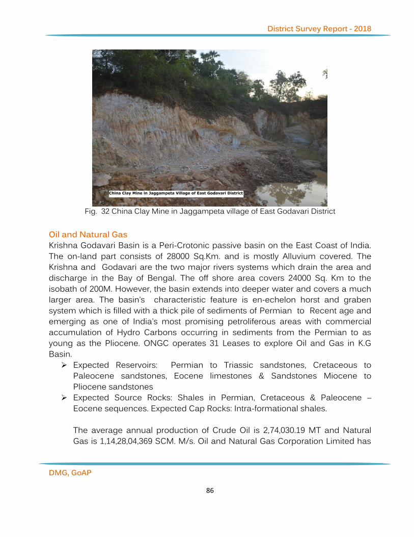
District Survey Report - 2018
DMG, GoAP
86
Fig. 32 China Clay Mine in Jaggampeta village of East Godavari District
Oil and Natural Gas Krishna Godavari Basin is a Peri-Crotonic passive basin on the East Coast of India. The on-land part consists of 28000 Sq.Km. and is mostly Alluvium covered. The Krishna and Godavari are the two major rivers systems which drain the area and discharge in the Bay of Bengal. The off shore area covers 24000 Sq. Km to the isobath of 200M. However, the basin extends into deeper water and covers a much larger area. The basin’s characteristic feature is en-echelon horst and graben system which is filled with a thick pile of sediments of Permian to Recent age and emerging as one of India’s most promising petroliferous areas with commercial accumulation of Hydro Carbons occurring in sediments from the Permian to as young as the Pliocene. ONGC operates 31 Leases to explore Oil and Gas in K.G Basin.
➢ Expected Reservoirs: Permian to Triassic sandstones, Cretaceous to Paleocene sandstones, Eocene limestones & Sandstones Miocene to Pliocene sandstones
➢ Expected Source Rocks: Shales in Permian, Cretaceous & Paleocene – Eocene sequences. Expected Cap Rocks: Intra-formational shales. The average annual production of Crude Oil is 2,74,030.19 MT and Natural Gas is 1,14,28,04,369 SCM. M/s. Oil and Natural Gas Corporation Limited has

District Survey Report - 2018
DMG, GoAP
87
obtained Petroleum Mining Lease (PML) permissions for Oil and Natural Gas in East Godavari District as detailed below in Table7.2:
Table 7.2: (PML) permissions for Oil and Natural Gas in East Godavari District Sl. No. Name of PML Area
(Sq.Km) Area falling under PML Mandal
1 Mori-1 6.50 Mori Sakhinetipalli 2 Kesavadasapalem 25.50 Kesavadasapalem Sakhinetipalli 3 Tatipaka-Pasarlapudi 62.00 Tatipaka Mamidikuduru 4 Manepalli 10.00 Manepalli P.Gannavaram 5 Razole – 1 & 2 18.85 Razole Razole 6 Pasarlapudi – 8 & 9 12.10 Pasarlapudi Mamidikuduru 7 Mandapeta – 19 & West 26.00 Mandapeta Mandapeta
8 Srikatpalli–Pasarlapudi (24)-Gopavaram
163.00 Pasarlapudi Mamidikuduru
9 Kesanapalli(Regrant) 3.70 Kesanapalli Sakhinetipalli
Uses: Nearly all pesticides and many fertilizers are made from oil or oil by-products. Gas provides electricity and is also used for cooking. It can also be used in the form of compressed natural gas (CNG) or liquefied natural gas (LNG) as a transportation fuel for vehicles. 7.3. Availability of Sand, Gravel and Aggregate Resources River Godavari enters East Godavari District at Yetapaka Mandal and flows as Akhanda Godavari until Dowlaiswaram Sir Aurthor Cotton Barrage. Subsequently, the River Godavari splits into three branches and flows as Gowthami, Vasishta and Vynateya. The Sand Reaches in this District exist along Akhanda Godavari Left Bank, Gowthami Left & Right Banks, Vasishta Left Bank and Vynateya Left & Right Banks. River Godavari flows through East Godavari approximately a distance of 250 KM and merges into the Bay of Bengal at Antarvedi. The Yeleru River flows through Yeleswaram, Prathipadu, Kirlampudi, Peddapuram Mandals in East Godavari District. There is only one identified reach in Yeleswaram Mandal i.e., Marriveedu. The Thandava River flows through Tuni & Kotananduru mandals in East Godavari District. The sand reaches along Thandava River were not recommended as per AP WALTA Rules by the line departments during the course of Joint Inspection. The Sand Reach details

District Survey Report - 2018
DMG, GoAP
88
along the Godavari River Banks are given in Table 7.1. The Gravel and Aggregate resources in East Godavari District: Khondalite group of rocks are used for Building Stone and Charnockite group of rocks are used for Road Metal for civil constructions. The Deccan traps overlie the Tirupathi Sand Stones and are exposed only in a smaller area of Rajahmundry, Rajanagaram and Gandepalli mandals. The Traps extended over a distance of 32 Km from Katheru in the west to Katrevulapalli, Jaggampeta Mandal in the East. The traps are basaltic in composition and it is useful for Road Metal for construction of civil works. The Gravel and Aggregate resource place-wise information is given in Table 7.2. Road Metal/Building Stones Charnockites/Khondalites Road Metal occurred in Charnockite Group of Eastern Ghats Super Group of Archaean age, where the Eastern Ghat Mobile Belt is tapering to less than 20 km width and trending in NNE-SSW in the area and Charnockite zone represented mainly of Charnockite and Basic Granulite. The Charnockite in the area forms dome shaped steeply sloping hills. The rock is medium to coarse grained texture comprises Greasy quartz, hypersthenes, orthoclase and plagioclase with or without Garnet. In East Godavari District, Charnockite Road Metal quarries are located in Seethanagaram, Gokavaram, Korukonda, Rampachodavaram, Yeleswaram, Prathipadu, Rowthulapadu, Tuni, Sankhavaram & Kotananduru Mandals. The available Charnockite rock in the district is in massive nature which can sustain rock strength for usage of civil works. However consisting of predominantly irregular joints, it is not useful for cutting and polishing. As such these are being utilized for breaking and crushing purpose only and the aggregate products so derived have been used in Civil Construction works, Railway Ballast and for making Railway Sleepers, etc., In East Godavari District, Building Stone occurred in Khondalite Group of Easter Ghats. The Villagers of Prathipadu, Kirlampudi & Sankhavaram Mandals generally used Khondalite Rocks as Building Stone for foundation and construction of Retaining Walls from the ancient period. Further, the Irrigation Department is using the Building Stone in Revetment along the Flood Bank and Construction of groins to prevent the erosion of the Flood Banks/Lanka lands.

District Survey Report - 2018
DMG, GoAP
89
Uses: The available Charnockite rock in the district is in massive nature which can sustain rock strength for usage of civil works. However, consisting of predominantly irregular joints, it is not useful for cutting and polishing. As such these are being utilized for breaking and crushing purpose only and the aggregate products derived so have been used in Civil Construction works, Railway Ballast and making Railway Sleepers, etc.
Fig. 33 Charnockite Specimen East Godavari District
Fig. 34 Charnockite Hill Deposite in East Godavari District

District Survey Report - 2018
DMG, GoAP
90
Deccan Traps (Basaltic Lava) In East Godavari District, Road Metal occurred in Deccan Trap formation of upper cretaceous period. The Deccan traps overlie the Tirupathi. Sand Stones and are exposed only in a smaller area of Rajahmundry, Rajanagaram and Gandepalli mandals. Road Metal quarries are located in Kateru, Konthamuru & Kolamuru in Rajamahendravaram Rural, Palacherla, Rajanagaram and Gandepalli Mandals. The Traps extended over a distance of 32 Km from Katheru in the west to Katrevulapalli, Jaggampeta Mandal in the East. The traps are basaltic in composition and it is useful for Road Metal for construction of civil works.
Fig. 35 Basalt Specimen in Rajamahendravaram, East Godavari District
Fig. 36 Basalt Rock in Deccan Trap Formation in Rajamahendravaram, East Godavari
Gravel

District Survey Report - 2018
DMG, GoAP
91
Gravel is formed due to in situ weathering of Khondalite rocks of Eastern Ghat Super Group of Archaean age due to the effect of wind, water & temperature. Large gravel deposits are a common geological feature, being formed as a result of the weathering and erosion of rocks. The action of rivers and waves tends to pile up gravel in large accumulations. This can sometimes result in gravel becoming compacted and lithified into the sedimentary rock called conglomerate. In East Godavari District, Gravel formations are generally occurred in upland i.e. Table plateau which consists of formations of Miocene to mio-pleiestocene period and weathering of Khondalite suit of rocks Mineral constituent namely Gravel. Gravel formations are distributed in Peddapuram, Samalkot, Gandepalli, Gollaprolu, Biccavolu, Anaparthi, Mandapeta, Rangampeta and Rajanagaram Mandals. Uses: Gravel is used for formation of Kacha roads and filling low level areas.
Fig. 37 Gravel quarry in East Godavari Earth In East Godavari District, Southern part of the district mostly covering Alluvial Soil formed by the Godavari Delta consists of Black cotton Soils, Sandy Soils, Loamy
District Survey Report - 2018
DMG, GoAP
92
Soils. The Mineral Earth is available in the Revenue Divisions of Rajamahendravaram, Amalapuram, Ramachandrapuram and Kakinada. Beach Sands In East Godavari District, Beach Sand Minerals like Zircon, Illimanite, Monozite, Rutile etc., are deposited along coastline of the Bay of Bengal stretching from Thondangi Mandal to Sakhinetipalli Mandal approximately covering a distance of 150 KM. Beach Sand Minerals usually categorized as Rare Earth Elements (REE) are characterized by high density, high melting point, high conductivity and high thermal conductance. A number of rare earth minerals contain thorium and uranium in variable amounts but thorium and uranium do not constitute essential components in the composition of the minerals. Rare earth materials are utilized in a wide range of critical products enabling many emerging green energy technologies, high-tech applications and defense systems such as hybrid cars, plug-in hybrid electric-vehicles (PHEVs), the latest generation of efficient wind power turbines, computer disc drives, missile guidance systems, etc. Monazite contains about 25.28% P2O5 which can be recovered as a by-product for manufacture of fertilizers and production of elemental phosphorus or its salts. Besides, rare earths, thorium is recovered from monazite. It is a source of atomic energy. An important use of thorium is for addition to tungsten in minute quantity (about 0.75%) to increase the ductility of tungsten wire and thus to facilitate its drawing into filaments used in electric lamps. Metallic thorium is also used in photoelectric cells and X-ray tubes and in certain alloys. Thorium is used as catalytic agent for various processes. Amongst thorium salts, thorium nitrate is used largely in the manufacture of incandescent gas mantles. Mesothorium, the chief radioactive element recovered as a byproduct in the chemical treatment of monazite, is marketed usually in the form of its bromide and used in self-luminous paints or enamels. Mesothorium is also used in the treatment of certain types of cancer and skin diseases. At present, there is no Beach Sand Mining Leases in East Godavari District.

District Survey Report - 2018
DMG, GoAP
93
Fig. 38 Beach Sand in Kona village in East Godavari
Sand Godavari River (V Order Stream) River Godavari enters into East Godavari District at Yetapaka Mandal and flows as Akhanda Godavari up to Dowlaiswaram Sir Aurthor Cotton Barrage. Subsequently, the Godavari splits into three branches and flows as Gowthami, Vasishta and Vynateya. The Sand Reaches in this District exist along Akhanda Godavari Left Bank, Gowthami Left & Right Banks, Vasishta Left Bank and Vynateya Left & Right Banks. River Godavari flows through East Godavari approximately a distance of 250 KM and merges into the Bay of Bengal at Antarvedi. The Sand Reach details along the Godavari River Banks are as follows: Uses: Sand is used to provide bulk, strength, and other properties to construction materials like asphalt and concrete. It is also used as a decorative material in landscaping. Specific types of sand are used in the manufacture of glass and as a moulding material for metal casting. Table-7.3 The Sand Reach details along the Godavari river

District Survey Report - 2018
DMG, GoAP
94
Sl.
No.
Name of the River
Name of the Sand Reach
Chainage Type of Reach
1
Akhanda Godavari Left Bank
Vangalapudi 32.000 to 35.00 KM Open Reach
2 Muggalla 26.000 to 32.000 KM Open Reach
3 Munikudali 25.000 to 26.000 KM Open Reach
4 Katavaram 22.000 to 25.000 KM De-siltation
5 Rajahmundry 3.000 to 8.800 KM De-siltation
6
Gowthami Left Bank
Vemagiri – Kadiyapulanka
3.000 to 8.000 KM Open Reach
7 Jonnada 9.000 to 19.400 KM Open Reach
8 Tatapudi 23.200 to 25.900 KM Open Reach
9 Kapileswarapuram 29.000 to 29.900 KM Open Reach
10 Korumilli 30.400 to 32.400 KM Open Reach
11 Kotipalli 40.000 to 48.000 KM Open Reach
12 Pillanka 55.000 to 60.400 KM By Boats
13 Govallanka 59.000 to 60.400 KM By Boats
14
Gowthami Right Bank
Bobbarlanka – Peravaram
3.00 to 5.00 KM Open Reach
15 Vaddiparru 7.400 to 10.800 KM Open Reach
16 Atreyapuram 10.000 to 15.000 KM Open Reach
17 Ubalanka 19.000 to 22.000 KM Open Reach

District Survey Report - 2018
DMG, GoAP
95
18 Ravulapalem 22.000 to 24.900 KM Open Reach
19 Mandapalli 27.000 to 29.000 KM Open Reach
20 Kothapeta – Kedaralanka
27.000 to 31.000 KM Open Reach
21 Vadapalem – Narayanalanka
31.400 to 34.200 KM Open Reach
22 Invallilanka – Veeravallipalem
45.000 to 51.000 KM Open Reach
23 Kondakuduru 51.000 to 55.000 KM Underwater excavation
24 Kommanapalli – Gedallanka
58.000 to 58.500 KM Open Reach
25 Muramalla 59.000 to 72.000 KM By Boats
26 Pallamkurru 75.000 to 79.100 KM By Boats
27
Vasishta Left Bank
Rajavaram – Velicheru
3.500 to 7.500 KM Open Reach
28 Pulidindi 8.800 to 10.500 KM Open Reach
29 Tadipudi 12.000 to 14.000 KM Open Reach
30 Ankampalem 19.000 to 30.000 KM Open Reach
31 Gopalapuram 30.000 to 44.200 KM Open Reach
32 Y.V.Palem – Bendapudi
44.200 to 48.400 KM Open Reach
33 Soampalli 48.400 to 63.000 KM Underwater

District Survey Report - 2018
DMG, GoAP
96
excavation
34 Dindi 63.000 to 80.000 KM By Boats
35 Tekisettipalem - Sakhinetipalli
63.000 to 80.000 KM Underwater excavation
36
Vynateya Right Bank
D.S.Palem 0.800 to 0.900 KM Open Reach
37 Manepalli 5.000 to 10.000 KM Open Reach
38 Pedapatnam – Appanapalli
5.000 to 15.000 KM Underwater excavation
39 Pasarlapudi 15.000 to 18.000 KM By Boats
40 Vynateya Left Bank
Bodaskurru 22.000 to 35.000 KM Underwater excavation
41
PIP Flood Bank
Yedurlanka 0.000 to 12.000 KM
Underwater excavation
42 Guttinadeevi 12.000 to 15.000 KM
43 Pasuvulanka 35.000 to 40.575 KM
44 Kesanakurru 22.0 35.000 KM
From the above sand reaches on an average sand quantities of 25.00 to 30.00 Lakhs per annum have been excavating to meet the needs of public in East Godavari District and adjacent Districts.

District Survey Report - 2018
DMG, GoAP
97
Fig. 39 Sand deposits in River Godavari Yeleru River (III Order Stream) The Yeleru River originated from Eastern Ghats of Y.Ramavaram Mandals and flows through Addateegala (Agency area), Yeleswaram, Prathipadu, Kirlampudi, Peddapuram Mandals in East Godavari District. There is only one identified reach in Yeleswaram Mandal i.e., Marriveedu. There is a possibility of small Sand shoals at Yeleswaram and Kirlampudi Mandals for utilization of sand for local consumption only.
Thandava River (III Order Stream) The Thandava River originated at Eastern Ghat hills from Chodavaram Mandal, Visakha District and flows through Kotananduru & Tuni Mandals of East Godavari District. There is a possibility of small Sand shoals at Kotananduru and Tuni Mandals for utilization of sand for local consumption only.

District Survey Report - 2018
DMG, GoAP
98
Table-7.4
Annexure - I
Statement showing the list of leases for Major and Minor Minerals and details of lease wise production and Revenue collections during the last three years pertaining to O/o Asst. Director of Mines & Geology, Rajamahendravaram
Sl.No
. LesseeID Lessee Name
Mineral Name
Location Extent (in
Hectares)
Lease Period Production(Dispatches) Mineral Revenue Collections Remar
ks Survery No
Village Mandal From To 2015-16 2016-17
2017-18
2015-16
2016-17 2017-18
1 4110700
12 Smt K. Anasuya
Road Metal
207/1 GONTUVANIPALEM
Addateegala
2 27-Jan-
07 26-Jan-
17 1050 1350 0 100075 21239.73 0
Renewal applied
2 4110703
91 P.Kannayamma
Road Metal
207/1 GONTUVANIPALEM
Addateegala
2 27-Jan-
07 26-Jan-
17 880 1350 0 100000 21107.73 0
Renewal applied
3 4110800
04 Smt Palla Sanyasamma,
Road Metal
207/1 GONTUVANIPALEM
Addateegala
1 10-Jun-
08 9-Jun-18
450 670 2050 50000 59550.87 1312
50
4 4110800
06
M/s Bhavani Girijana Quarry Workers LC C Society
Road Metal
207/1 GONTUVANIPALEM
Addateegala
0.85 26-Jun-
08 25-Jun-
18 0 560 1266 0 42500
52450
5 4110800
07 Sri Manepalli Chandra Rao,
Road Metal
207/1 GONTUVANIPALEM
Addateegala
9.5 31-Jul-
08 30-Jul-18
5150 6356 7855 497564 68279.45 5891
25
6 4110800
08 Sri Manepalli Chandra Rao
Road Metal
207/1 GONTUVANIPALEM
Addateegala
1.4 31-Jul-
08 30-Jul-18
1500 1078 8451 100000 553350 1588
25
7 4110802
15
M/s Gontivanipalem Girijana QW Indl.co Society
Road Metal
207/1 GONTUVANIPALEM
Addateegala
1.507
4-Jul-08
3-Jul-18 750 1000 1005 75531 89537.65
75350
8 4110802
16 M/s Vijaya Girijana Q. L.C.c. Society
Road Metal
207/1 GONTUVANIPALEM
Addateegala
3.87 4-Jun-
08 3-Jun-18
2320 2760 4950 213117 232552.9
5 1719
59
9 4111200
05 Sri Pallala Sanyasamma
Road Metal
207/1 GONTUVANIPALEM
Addateegala
0.125
18-Dec-12
3-Jun-18 150 150 1300 9333 11250
97250
10 4110602
14 Sri P.Krishna
Road Metal
24 Puligogulapadu
Addateegala
1.85 1-Jun-
06 31-May-
16 906 0 0 16849 0 0
Expired/Determined
11 4110800
10 Sri J. Satya Vara Prasad
Road Metal
24 PULIGOGULAPADU
Addateegala
2 25-Jun-
08 24-Jun-
18 936 1533 1333 114015 118653.4
1 1000
00

District Survey Report - 2018
DMG, GoAP
99
12 4110802
17 Sri N.Naga Raju
Road Metal
24 PULIGOGULAPADU
Addateegala
6 4-Jul-
08 3-Jul-18
2955 4050 3240 355835 303750 3000
00
13 4111402
19 Sri karri Sambasiva Reddy Gravel 8/1DP
DUPPALAPUDI
Anaparthi 3.08 29-Jan-
14 28-Jan-
17 225040
16750 0
5692977 400228 0
Expired/Determined
14 4111503
75 A.SATISH KUMAR Gravel 8/1CP Duppalapudi Anaparthi 0.87
26-Jun-15
4-Apr-20 54800 0 0
1547045 0 0
15 4111604
28 A.RAMESH Gravel 8/1C
DUPPALAPUDI
Anaparthi 0.79
7 13-Apr-
16 12-Apr-
19 0 2200
0 5500 0 628120 1965
00
16 4111604
37 S.SIVANNARAYANA REDDY Gravel 23
DUPPALAPUDI
Anaparthi 1.84
1 21-Jun-
16 2-Sep-19
0 8850
0 0 0 2654960 0
17 4111403
49 MALLIDI VEERA RAGHAVA REDDY
Gravel 28 BALABHADRAPURAM
Biccavolu 4.07
7 16-Apr-
14 15-Apr-
19 18850 8000
0 5430 664315 2172800 0
18 4111403
55 S.VEERA VENKATA SATYANARAYANA REDDY
Gravel 49/P BALABHADRAPURAM
Biccavolu 2.4 12-
May-14
11-May-17
49806 2500 0 126093
6 0 0
Expired/Determined
19 4111503
60 K.V.V.S.SUBRAHMANYAM Gravel 73
BALABHADRAPURAM
Biccavolu 1.01
2 20-Jan-
15 3-Jan-17
66798 1000 0 149313
5 0 0
Expired/Determined
20 4111504
09 S.SIVANNARAYANA REDDY Gravel
152/4B,4C,4D,4E,4F,4
G
KAPAVARAM Biccavolu 1.61
8 9-Oct-
15 6-Jul-20
82875 1119
30 0 252434
1 3293100 0
21 4111604
38 S.SIVANNARAYANA REDDY Gravel 152/2 KAPAVARAM Biccavolu
0.745
21-Jun-16
12-Sep-20 0 375 0 0 30000 0
22 4111604
41 G.SATYA PRAKASH Gravel 108/1
THUMMALAPALLE
Biccavolu 0.98
7 21-Jun-
16 30-Jun-
21 0 1116 2450 0 39600 2718
0
23 4110904
40 P.SATYANARAYANA Quartz 26 KESARAM Chintur
0.874
25-Mar-09
24-Mar-29 0 300 2137 0 37500
180500
24 4111002
22 Sri P.S.V.S Chowdary Gravel
255/2P,3,4P,5
Gandepalle Gandepalle 2.38 #N/A #N/A 10005 0 0 205000 0 0
Expired/Determined
25 4120502
64 Sri DVV Ramana Reddy
China Clay (Crude)
23/2P,24/2P
GANDEPALLE Gandepalle 1.03
3 21-
Nov-05 20-Nov-
25 3900 2650 5400 25322 83808
260000
26 4121002
99
M/s Hindustan Sanitaryware and Industries Ltd
China Clay (Crude)
3/P,4/P Gandepalle Gandepalle 1.78 27-
Dec-10 26-Dec-
30 1000 0 0 0 0 0
27 4111403
58 SIDHVI INFRASTRUCTURE PROJECTS LIMITED
Gravel
212/1 2 3
AND 213/3
P.nayakampalle
Gandepalle 2.40
8 8-Sep-
14 13-Sep-
16 1305 0 0 0 0 0
Expired/Determined

District Survey Report - 2018
DMG, GoAP
100
28 4111403
59 SIDHVI INRASTRUCTURE PROJECTS LIMITED
Gravel 212/6 P.nayakampalle
Gandepalle 0.72
8 8-Sep-
14 13-Sep-
16 300 0 0 29729 7091.34 0
Renewal applied
29 4111503
88 JETTY SATYANARAYANA & OTHERS
Ordinary Earth
79/P,2P,3P 4P
YELLAMILLI Gandepalle 5.75 3-Feb-
15 2-Feb-25
800 0 3500 287934 733876.7
1 1610
000
30 4111503
88 JETTY SATYANARAYANA & OTHERS
Road Metal
79/P,2P,3P 4P
YELLAMILLI Gandepalle 5.75 3-Feb-
15 2-Feb-25
2300 1065
0 29500 0 0 0
31 4111503
88 JETTY SATYANARAYANA & OTHERS
Ballast 79/P,2P,3P 4P
YELLAMILLI Gandepalle 5.75 3-Feb-
15 2-Feb-25
300 1000 0 0 0 0
32 4111503
88 JETTY SATYANARAYANA & OTHERS
Boulders 79/P,2P,3P 4P
YELLAMILLI Gandepalle 5.75 3-Feb-
15 2-Feb-25
0 1000 0 0 0 0
33 4120202
96 Sri K.Venkata Rao
China Clay (Crude)
21-Jan ZAMINDAR RAGAMPETA
Gandepalle 1.01 7-Aug-
02 6-Aug-22
4650 4530 8650 138850 226500 4325
00
34 4120402
74 Smt K.V.V.S.A.Subba Laxmi Fire Clay 63/3B
ZAMINDAR RAGAMPETA
Gandepalle 0.72
9 22-
Nov-04 21-Nov-
24 2950 3400 2700 93099 161000 1300
00
35 4120403
52 K.SRINIVASA RAO
China Clay (Crude)
21/2,22/1
22/2
ZAMINDAR RAGAMPETA
Gandepalle 2.41
2 8-Dec-
04 7-Dec-24
4650 4000 6200 120441 201180 3063
56
36 4110503
32 M/s Mars Granites
Color Granite-Leptinites
486/1,488/1
NELLIPUDI Gangavaram
1.52 5-Oct-
05 4-Oct-25
1450.073 2345.504
1203.551
3663330 7033044
3593879
37 4111604
42 RATHOD PREM
Color Granite-Leptinites
487 NELLIPUDI Gangavaram
1 10-
Aug-16 9-Aug-36
0 278.905
725.857 0 842000
2155294
38 4110602
26 Sri K.Srinivas
Road Metal
1 Pothandorapalem
Gangavaram
1.5 12-
May-06
10-May-18
600 0 1002 75081 89054.8 7515
0
Renewal applied
39 4110902
27 A.P. Tribal Mines Co. Ltd
Road Metal
1 POTHANDORAPALEM
Gangavaram
1.5 12-
Mar-09 11-Mar-
19 0 1000 1650 0 75000 1237
50
40 4110702
29 Sri P.Ananda Reddy
Road Metal
104 KALIJOLLA Gokavaram 2.02 7-Nov-
07 6-Nov-27
936 600 450 101086 119927.1
3 1010
00
41 4110702
30 Sri P.Veera Reddy
Road Metal
104 KALIJOLLA Gokavaram 2.02 7-Nov-
07 6-Nov-27
938 600 450 101705 119925.3
2 1010
00
42 4110702
31 Sri K.Seetha Rama Laxmana Reddy
Road Metal
104 KALIJOLLA Gokavaram 2.19 7-Nov-
07 6-Nov-27
964 600 450 109512 129360 1095
00
43 4110702
32 Sri K.Nagi Reddy
Road Metal
104 KALIJOLLA Gokavaram 1.27 7-Nov-
07 6-Nov-27
697 600 300 66474 72922.91 6307
7

District Survey Report - 2018
DMG, GoAP
101
44 4110802
33 M/s Swasthik Metals
Road Metal
359/7 KALIJOLLA Gokavaram 1.45
6
20-May-
08
19-May-18
0 540 0 0 0 1456
00
45 4111002
35 Smt K. Atchuta Padma
Road Metal
104/P KALIJOLLA Gokavaram 1.32 3-Feb-
10 2-Feb-20
630 300 0 66000 75017.67 0
46 4110700
18 Sri M.Srinivas
Road Metal
546 MALLAVARAM
Gokavaram 2.63 27-
Nov-07 26-Nov-
27 1068 900 0 131500 156065.8
9 1314
49
47 4110702
28 Sri S.Subash Chandra Bose
Road Metal
359 MALLAVARAM
Gokavaram 3 27-Oct-
07 28-Oct-
27 0 3000 2000 150000 178109.5
9 1409
76
48 4110704
44 T.NAGESWARA RAO
Road Metal
359 MALLAVARAM
Gokavaram 2 18-Oct-
07 17-Oct-
27 0 1333 750 0 100000 1000
00
49 4110704
46 PRUDHVI GRANITES
Road Metal
546 MALLAVARAM
Gokavaram 2 2-Nov-
07 6-Nov-17
0 900 0 0 100000 0
Expired/Determined
50 4111504
32 M/S SWASTHIK METALS
Road Metal
359/7 MALLAVARAM
Gokavaram 0.57
5 24-
Feb-15 23-Feb-
25 0 420 0 0 0 0
51 4111504
33 M/S SWASTHIK METALS
Road Metal
359/10 MALLAVARAM
Gokavaram 0.88
6 24-
Feb-15 23-Feb-
25 0 420 0 0 0 0
52 4110600
19 Sri T. Venkata Reddy
Road Metal
1P Thantikonda Gokavaram 1 20-
May-06
19-May-16
564 0 0 0 0 0
Expired/Determined
53 4129702
92 M/s Bharat Clays
China Clay (Crude)
102/3 JAGGAMPETA Jaggampeta
2.023
7-Oct-97
10-Jun-37
0 750 1950 0 37500 9750
0
54 4120002
95 Sri K.Srinivasa Rao
China Clay (Crude)
26 RAMAVARAM Jaggampeta
0.882
18-Feb-00
17-Feb-20
3650 2300 4100 117353 113834 2000
00
55 4120102
66 M/s Jyothula Industries
China Clay (Crude)
21 RAMAVARAM Jaggampeta
2.023
20-Nov-01
1-Sep-36 1500 1400 1800 69645 80324
75000
56 4129802
76 Sri D.V.V.Ramana Reddy
China Clay (Crude)
19-Feb RAMAVARAM Jaggampeta
0.607
20-Aug-98
19-Aug-18
1350 4630 4500 35200 231500 2250
00
Renewal applied
57 4120802
63 M/s Gowri Shankar Mines Fire Clay 536/P KADIAM Kadiam
1.214
10-Jul-08
9-Jul-28 4130 2880 2170 145044 144000
108500
58 4121002
73 Sri D. Subba rao Fire Clay 533/1 KADIAM Kadiam 1.66
6-Jul-10
5-Jul-30 1010 475 20 50350 24900 0
59 4129602
71 Sri S.Sitharama Raju Fire Clay 536/3 KADIAM Kadiam
2.233
22-Oct-96
21-Oct-18 16604
22300 20422 679446 1115000
1004595
60 4111300
20 Sri K.V.V.Satyanarayana Murthy
Gravel 135 Vemagiri Kadiam 2.21
8 25-
Mar-13 24-Mar-
18 12270 0 0 233061 0 0 Expired/Dete

District Survey Report - 2018
DMG, GoAP
102
rmined
61 4111604
23 N.GANAPATHI RAO Gravel 86/1 VEMAGIRI Kadiam
0.821
24-Feb-16
23-Feb-21 900
15300 28500 0 568160
767840
62 4110802
37
PRATHIPADU HARIJANA QUARRY KARMIKA SANGAM
Road Metal
66/1Y Jagapathinagaram
Kirlampudi 1 4-Dec-
06 3-Dec-16
300 0 0 0 0 0
Expired/Determined
63 4110802
37
PRATHIPADU HARIJANA QUARRY KARMIKA SANGAM
Building Stone
66/1Y Jagapathinagaram
Kirlampudi 1 4-Dec-
06 3-Dec-16
360 0 0 3000 0 0
Expired/Determined
64 4111202
40 M/s Sai Ram Building Stone
Building Stone
1 VELANKA Kirlampudi 1 1-Mar-
12 28-Feb-
22 420 720 420 76 63369.87 5000
0
65 4110600
23 Smt A.Manga Devi
Road Metal
75/3A BOLLEDDUPALEM
Korukonda 1 29-
Mar-06 28-Mar-
26 750 690 900 62136 51750 6750
0
66 4110600
24 Sri K.P.C.S.Poojitha Rao
Road Metal
75/3A Bolleddupalem
Korukonda 1 21-
Aug-06 30-Mar-
18 492 0 0 9742 0 0
Renewal applied
67 4111202
42 Sri Venturi Rama Gopal
Road Metal
75/3A BOLLEDDUPALEM
Korukonda 1 6-Sep-
12 5-Sep-22
450 300 0 50000 56945.21 0
68 4111200
28 Sri Vundamatla Narayana Rao
Gravel 80/2P Kesavaram Mandapeta 1.30
8 #N/A #N/A
12450 0 0 251726 0 0
Expired/Determined
69 4111503
78 K.SIVANNARAYANA Gravel 79/1 KESAVARAM Mandapeta
0.542
20-Feb-15
19-Feb-18 9750 4600 2200 268916 142600
47198
70 4111504
10 K.MUNEESWARA RAO Gravel 69.P KESAVARAM Mandapeta
2.205
4-Nov-15
3-Nov-20 20780
39200 0 623600 1104900 0
71 4111503
86 N.RAJESWARI Gravel
103/1A7,1A8,1A11,1
A12
VEMULAPALLE at SEETAY
Mandapeta 1.62 13-Jul-
15 12-Jul-17
70500 5960 0 204320
0 114000 0
Expired/Determined
72 4111604
31 P.ESWARA REDDY Gravel
103/A2/C
VEMULAPALLE at SEETAY
Mandapeta 1.61
9 25-Apr-
16 24-Apr-
21 0 6744
5 0 0 2023402 0
73 4110504
51 G.PADMAVATHI Quartz
17/A 17/VU
Rangapuram Nellipaka 1.25 27-
Sep-05 26-Sep-
25 0 0 1400 0 0 9247
8
74 4110702
51 Sri Prathipati Surya Bhaskar Rao
Gravel 897/3A
P PEDDAPURAM
Peddapuram
1.417
9-Jan-14
8-Jan-17 42640
66050 0
1062800 1923775 0
Expired/Determined
75 4111103
44 K.VENKATA KRISHNA REDDY
Gravel 439 Peddapuram Peddapuram
2.023
22-Jul-11
21-Jul-16 5775 0 0 125772 0 0
Expired/Determined
76 4111400 Sri Gunnam Surya Rao Gravel 897/3A PEDDAPURA Peddapura 2.02 9-Jan- 8-Jan-17 282450 3020 0 708932 824744 0
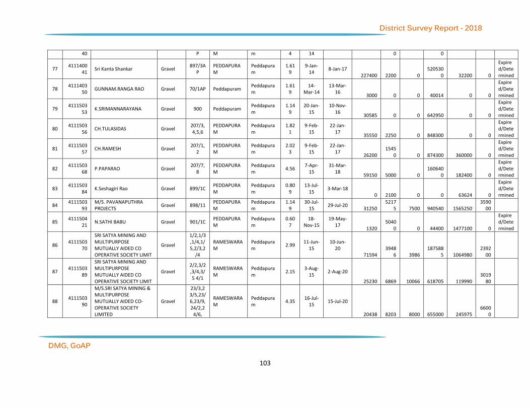
District Survey Report - 2018
DMG, GoAP
103
40 P M m 4 14 0 0
77 4111400
41 Sri Kanta Shankar Gravel
897/3AP
PEDDAPURAM
Peddapuram
1.619
9-Jan-14
8-Jan-17 227400 2200 0
5205300 32200 0
Expired/Determined
78 4111403
50 GUNNAM.RANGA RAO Gravel 70/1AP Peddapuram
Peddapuram
1.619
14-Mar-14
13-Mar-16
3000 0 0 40014 0 0
Expired/Determined
79 4111503
53 K.SRIMANNARAYANA Gravel 900 Peddapuram
Peddapuram
1.149
20-Jan-15
10-Nov-16
30585 0 0 642950 0 0
Expired/Determined
80 4111503
56 CH.TULASIDAS Gravel
207/3,4,5,6
PEDDAPURAM
Peddapuram
1.821
9-Feb-15
22-Jan-17
35550 2250 0 848300 0 0
Expired/Determined
81 4111503
57 CH.RAMESH Gravel
207/1,2
PEDDAPURAM
Peddapuram
2.023
9-Feb-15
22-Jan-17
26200 1545
0 0 874300 360000 0
Expired/Determined
82 4111503
68 P.PAPARAO Gravel
207/7,8
PEDDAPURAM
Peddapuram
4.56 7-Apr-
15 31-Mar-
18 59150 5000 0
1606400 182400 0
Expired/Determined
83 4111503
84 K.Seshagiri Rao Gravel 899/1C
PEDDAPURAM
Peddapuram
0.809
13-Jul-15
3-Mar-18 0 2100 0 0 63624 0
Expired/Determined
84 4111503
93 M/S. PAVANAPUTHRA PROJECTS
Gravel 898/11 PEDDAPURAM
Peddapuram
1.149
30-Jul-15
29-Jul-20 31250
52175 7500 940540 1565250
359000
85 4111504
21 N.SATHI BABU Gravel 901/1C
PEDDAPURAM
Peddapuram
0.607
18-Nov-15
19-May-17
1320 5040
0 0 44400 1477100 0
Expired/Determined
86 4111503
70
SRI SATYA MINING AND MULTIPURPOSE MUTUALLY AIDED CO OPERATIVE SOCIETY LIMIT
Gravel
1/2,1/3,1/4,1/5,2/3,2
/4
RAMESWARAM
Peddapuram
2.99 11-Jun-
15 10-Jun-
20 71594
39486 3986
1875885 1064980
239200
87 4111503
89
SRI SATYA MINING AND MULTIPURPOSE MUTUALLY AIDED CO OPERATIVE SOCIETY LIMIT
Gravel 2/2,3/2,3/4,3/5 4/1
RAMESWARAM
Peddapuram
2.15 3-Aug-
15 2-Aug-20
25230 6869 10066 618705 119990 3019
80
88 4111503
90
M/S.SRI SATYA MINING & MULTIPURPOSE MUTUALLY AIDED CO-OPERATIVE SOCIETY LIMITED
Gravel
23/3,23/5,23/6,23/9,24/2,2
4/6,
RAMESWARAM
Peddapuram
4.35 16-Jul-
15 15-Jul-20
20438 8203 8000 655000 245975 6600
0

District Survey Report - 2018
DMG, GoAP
104
89 4111503
95
M/s.SRI SATYA MINING & MULTIPURPOSE MUTUALLY AIDED CO-OP SOCIETY LIMITED
Gravel 6/1,6/2,6/6,6/
8
RAMESWARAM
Peddapuram
2.18 26-
Aug-15 25-Aug-
20 6500 3022 2900 243907 87200
87200
90 4111503
96
SRI SATYA MINING AND MULTIPURPOSE MUTUALLY AIDED CO OPERATIVE SOCIETY LIMIT
Gravel 7/1,8/1
,8/3 RAMESWARAM
Peddapuram
1.619
26-Aug-15
25-Aug-20
32879 2161 2158 939717 64800 1295
20
91 4111503
97
SRI SATYA MINING AND MULTIPURPOSE MUTUALLY AIDED CO OPERATIVE SOCIETY LIMIT
Gravel 12-Feb RAMESWARAM
Peddapuram
0.526
26-Aug-15
25-Aug-20
4485 3707 0 111200 90000 4208
0
92 4111503
98
M/s. SRI SATYA MINING & MULTIPURPOSE MUTUALLY AIDED CO-OP SOCIETY LIMITED
Gravel 6/4,6/9 RAMESWARAM
Peddapuram
0.315
26-Aug-15
25-Aug-20
3340 4727 0 107800 128995 2520
0
93 4111503
99
SRI SATYA MINING AND MULTIPURPOSE MUTUALLY AIDED CO OPERATIVE SOCIETY LIMIT
Gravel
10/1,10/3,10/4,10/5,10/6,1
0/7,
RAMESWARAM
Peddapuram
6.475
26-Aug-15
25-Aug-20
38145 1570
6 0 963400 471200 0
94 4111504
01
SRI SATYA MINING AND MULTIPURPOSE MUTUALLY AIDED CO OPERATIVE SOCIETY LIMIT
Gravel 11/1, 12/3
RAMESWARAM
Peddapuram
1.052
26-Aug-15
25-Aug-20
14745 1400 0 466990 0 0
95 4111504
02
SRI SATYA MINING AND MULTIPURPOSE MUTUALLY AIDED CO OPERATIVE SOCIETY LIMIT
Gravel 04-Mar Rameswaram Peddapuram
0.223
26-Aug-15
25-Aug-20
6020 0 0 185800 0 1784
0
96 4111504
04
SRI SATYA MINING AND MULTIPURPOSE MUTUALLY AIDED CO OPERATIVE SOCIETY LIMIT
Gravel 08-Feb RAMESWARAM
Peddapuram
0.546
26-Aug-15
20-Aug-20
8135 5634 10828 257000 146995 3466
80
97 4111504
14
M/S.SRI SAI VENKATA VIGNESH MULTI PURPOSE AND LABOUR CONTACT MUTUALLY AIDED CO-OPERATIVE SOCIETY LTD
Gravel 15-May
RAMESWARAM
Peddapuram
0.546
26-Nov-15
25-Nov-17
700 9385 720 22000 280696 0
Expired/Determined
98 4111504
15
M/S.SRI SAI VENKATA VIGNESH MULTI PURPOSE & LABOUR CONTRACT MUTUALLY AIDED CO-
Gravel 13/3 14/4
RAMESWARAM
Peddapuram
1.093
26-Nov-15
25-Nov-17
13340 1255
0 0 400093 376500 0
Expired/Determined

District Survey Report - 2018
DMG, GoAP
105
OPERATIVE SOCIETY LTD
99 4111504
16
M/S.SRI SAI VENKATA VIGNESH MULTI PURPOSE & LABOUR CONTRACT MUTUALLY AIDED CO-OPERATIVE SOCIETY LTD
Gravel
14/3,6,21/1 AND
22/2,3
RAMESWARAM
Peddapuram
2.566
26-Nov-15
25-Nov-17
11300 2400 3420 339169 102800 0
Expired/Determined
100
411150417
M/S.SRI SAI VENKATA VIGNESH MULTI PURPOSE & LABOUR CONTRACT MUTUALLY AIDED CO-OPERATIVE SOCIETY LTD
Gravel 24/3,2
4/5 RAMESWARAM
Peddapuram
0.985
26-Nov-15
25-Nov-17
1415 5800 1320 39600 172743 0
Expired/Determined
101
411150418
SRI SATYA MINING AND MULTIPURPOSE MUTUALLY AIDED CO OPERATIVE SOCIETY LIMIT
Gravel 5/3,8/4
,8/6 RAMESWARAM
Peddapuram
1.307
21-Dec-15
20-Dec-20
0 1743 1742 0 0 1045
60
102
411150419
M/S.SRI SATYA MINING & MULTIPURPOSE MUTUALLY AIDED CO-OPERATIVE SOCIETY LIMITED
Gravel 13/5, 14/1, 14/2
RAMESWARAM
Peddapuram
1.618
21-Dec-15
20-Dec-20
0 1835
7 2160 0 550790 6472
0
103
411150420
SRI SATYA MINING AND MULTIPURPOSE MUTUALLY AIDED CO OPERATIVE SOCIETY LIMIT
Gravel 9/1,9/2,9/5,9/6,9/7
RAMESWARAM
Peddapuram
2.76 21-
Dec-15 20-Dec-
20 0
12580 0 0 266900 0
104
411160429
G.SATYANARAYANA Gravel 473/3 RAYABHUPALAPATNAM
Peddapuram
0.4 25-Apr-
16 24-Apr-
21 0 8075 3000 0 242250 7400
0
105
411070042
M/s Murali Krishna Stone Crusher
Road Metal
53 CHINA SANKARLAPUDI
Prathipadu 0.80
9 28-Apr-
07 27-Apr-
22 400 636 540 40500 55056.67 0
106
411070043
M/s Murali Krishna Stone Crusher
Road Metal
53 CHINA SANKARLAPUDI
Prathipadu 1.90
2 28-Apr-
07 27-Apr-
22 702 1268 1267 95000
112876.63
95120
107
411090450
M.SREENIVASA RAO Road Metal
53 China sankarlapudi
Prathipadu 13.5
9 20-
Nov-09 19-Nov-
19 0 0 6660 0 0 6795
00
108
411090450
M.SREENIVASA RAO Boulders 53 China sankarlapudi
Prathipadu 13.5
9 20-
Nov-09 19-Nov-
19 0 0 2400 0 0 0
109
411100046
PKR PROJECTS AND ENGINEERS
Road Metal
53 CHINA SANKARLAPUDI
Prathipadu 0.95 27-Apr-
10 1-Jul-27
13920 2100 1620 103150
0 149500 1183
03

District Survey Report - 2018
DMG, GoAP
106
110
411110048
PKR PROJECTS AND ENGINEERS
Road Metal
53 CHINA SANKARLAPUDI
Prathipadu 2.64
5 10-
Mar-11 9-Mar-21
2100 2496 27636 155000 184700 2072
265
111
411110049
PKR PROJECTS AND ENGINEERS
Road Metal
53 CHINA SANKARLAPUDI
Prathipadu 1 10-
Mar-11 15-Apr-
21 10320 2520 5400 663000 189000
403434
112
411120047
PKR PROJECTS AND ENGINEERS
Road Metal
53 CHINA SANKARLAPUDI
Prathipadu 6 25-
Aug-12 24-Aug-
22 31920 9802 50040
1809000 600000
3748100
113
411120058
PKR PROJECTS AND ENGINEERS
Road Metal
53 CHINA SANKARLAPUDI
Prathipadu 1.37
6 18-Jun-
12 17-Jun-
22 2700 2220 6492 181500 159000
480567
114
411120060
M/s Murali Krishna Stone Crusher
Road Metal
53 CHINA SANKARLAPUDI
Prathipadu 0.40
4 28-
Aug-12 27-Aug-
27 219 260 268 20000 23675.86
20268
115
411120061
M/s Murali Krishna Stone Crusher
Road Metal
53 CHINA SANKARLAPUDI
Prathipadu 0.09 28-
Aug-12 27-Aug-
27 32 236 60 4500 18498.29 4500
116
411120062
M/s Murali Krishna Stone Crusher
Road Metal
53 CHINA SANKARLAPUDI
Prathipadu 0.87 28-
Aug-12 27-Aug-
27 322 580 580 66 95151.78
43500
117
411120255
Sri Chakkapalli Suryanarayana
Road Metal
53 CHINA SANKARLAPUDI
Prathipadu 0.49 9-Jul-
12 8-Jul-22
183 3006
0 0 0 2258378.
15 2449
5
118
411130063
Sri G.Lakshmana Rao Road Metal
53 CHINA SANKARLAPUDI
Prathipadu 0.80
9 1-Mar-
13 28-Feb-
23 344 541 938 40500 44588.67 59
119
412070308
M/s Maheswari Minerals Laterite (Cement)
1 Chintaluru Prathipadu 24.281
28-Mar-07
27-Mar-27 240000 0 0
13770000 0 0
120
412080298
M/s Coral Mineral Product Ltd
China Clay (Crude)
419 DHARMAVARAM
Prathipadu 1.59
7 1-Feb-
08 31-Jan-
28 370 260 600 23955 29074.47 9881
121
412130319
Sri Andru Srinivas Laterite (Cement)
703 GIRIJANAPURAM
Prathipadu 10 7-Dec-
13 3-Dec-33
380000 8000
0 85000 215550
00 1611501
0 35085000
122
412130319
Sri Andru Srinivas
Laterite (Metallugical Grade)
703 GIRIJANAPURAM
Prathipadu 10 7-Dec-
13 3-Dec-33
0 4000
0 175000 0 0 0
123
412130320
Smt Manyam Venkata Rajani
Laterite (Cement)
703 GIRIJANAPURAM
Prathipadu 10 7-Dec-
13 3-Dec-33
60000 4250
0 45000 464250
0 9522510 18200000

District Survey Report - 2018
DMG, GoAP
107
124
412130320
Smt Manyam Venkata Rajani
Laterite (Metallugical Grade)
703 GIRIJANAPURAM
Prathipadu 10 7-Dec-
13 3-Dec-33
0 3000
0 105000 0 0 0
125
412130321
Smt Andru Sujatha Laterite (Cement)
7,03,589
GIRIJANAPURAM
Prathipadu 10 4-Dec-
13 3-Dec-33
240000 5450
0 130000 134700
00 1291251
0 33950000
126
412130321
Smt Andru Sujatha
Laterite (Metallugical Grade)
7,03,589
GIRIJANAPURAM
Prathipadu 10 4-Dec-
13 3-Dec-33
0 6000
0 90000 0 0 0
127
412130322
Sri M.Venkateswara Rao Laterite (Cement)
7,03,589
GIRIJANAPURAM
Prathipadu 10 4-Dec-
13 3-Dec-33
220000 1475
00 195000 136700
00 3326752
0 48575000
128
412130322
Sri M.Venkateswara Rao
Laterite (Metallugical Grade)
7,03,589
GIRIJANAPURAM
Prathipadu 10 4-Dec-
13 3-Dec-33
0 1045
00 235000 0 0 0
129
412130323
Sri Vempati Veerraju Laterite (Cement)
703 GIRIJANAPURAM
Prathipadu 10 4-Dec-
13 3-Dec-33
25000 3250
0 45000 180500
0 6147510 14825000
130
412130323
Sri Vempati Veerraju
Laterite (Metallugical Grade)
703 GIRIJANAPURAM
Prathipadu 10 4-Dec-
13 3-Dec-33
0 1250
0 80000 0 0 0
131
412130325
Andru Ramesh Babu Laterite (Cement)
7,03,589
GIRIJANAPURAM
Prathipadu 10 4-Dec-
13 3-Dec-33
145000 3450
0 150000 967500
0 1778751
0 43700000
132
412130325
Andru Ramesh Babu
Laterite (Metallugical Grade)
7,03,589
GIRIJANAPURAM
Prathipadu 10 4-Dec-
13 3-Dec-33
0 9500
0 170000 0 0 0
133
411020252
Sri Ch.Suryanarayana Road Metal
160 PEDA SANKARLAPUDI
Prathipadu 1.25 12-
Nov-02 11-Nov-
17 522
24830 0 0
1869281.51 0
Renewal applied
134
411130044
Sri Murali Krishna Constructions
Road Metal
160 PEDA SANKARLAPUDI
Prathipadu 0.80
9 1-Mar-
13 27-Apr-
23 300 541 541 40500 48052.64
40507
135
411090050
Sri G. Laxman Rao Gravel 80 PRATHIPADU Prathipadu 3 9-Jan-
09 8-Jan-19
2305 6024 5000 7027 358829.5
9 12
136
412140311
M/s Aurelia Laterite Mining pvt Ltd
Laterite (Cement)
USHP VANTHADA Prathipadu 67.599
21-Feb-14
16-Sep-28 482500
100500 0
32730381 6075000 0
137
412140326
Smt Kude Laxmi Laterite (Metallugical
7/1,7/2,10/P,11/P,12/
VANTHADA Prathipadu 10.417
13-May-
14
12-May-34
0 1619
00 221300 166111
1 2534084
0 20197500

District Survey Report - 2018
DMG, GoAP
108
Grade) P,16,17/P
138
412140326
Smt Kude Laxmi Laterite (Cement)
7/1,7/2,10/P,11/P,12/P,16,17
/P
VANTHADA Prathipadu 10.417
13-May-
14
12-May-34
30000 8660
0 24000 0 0 0
139
412990278
Sri Ch.Suresh Fire Clay 42 Bommuru(u) Rajamahendravaram(R)
4.856
30-Jul-99
29-Jul-19 800 0 0 72840 0 0
140
411060257
Sri K.Nagaiah Road Metal
770 KOLAMURU Rajamahendravaram(R)
0.76 1-Nov-
06 31-Oct-
16 0 300 0 0 38200 0
Renewal applied
141
411070070
Sri K.Suresh Kumar Road Metal
689/3 KOLAMURU Rajamahendravaram(R)
1.214
19-Jan-17
18-Jan-17
1950 300 0 139074 0 0
Expired/Determined
142
411080067
Sri I. Anil Kumar Road Metal
771/2P KOLAMURU Rajamahendravaram(R)
0.668
19-Nov-08
18-Nov-18
2100 1950 3300 150140 146250 2474
00
143
411080071
M/s Ch.Veerraju Associates
Road Metal
434,436/1,2,742/742/4C1,743/2AP
,
KOLAMURU Rajamahendravaram(R)
10.08
15-Dec-08
14-Dec-23
4800 6732 0 504000 72439.67 0
144
411080072
M/s Ch. Veerraju & Co., Road Metal
689/7A,
690/1C,690/2A,690/2B,690
/2C
KOLAMURU Rajamahendravaram(R)
1.842
15-Dec-08
14-Dec-23
1206 1230 1260 92000 92103.07 9460
0
145
411050064
M/s SriHari Metal Suppliers
Road Metal
147/1C RAJAHMUNDRY (PART)
Rajamahendravaram(R)
1.82 16-
Sep-05 15-Sep-
20 966 900 1200 91000 93290.27
90850
146
411070066
Sri B.Satyanarayana Road Metal
771/1, 791/1A
RAJAHMUNDRY (PART)
Rajamahendravaram(R)
1.14 3-Jul-
07 27-Aug-
16 978 750 0 57000 114000 0
Expired/Determined
147
411080065
Sri Satyanarayana Granites Road Metal
270/2,689/6
RAJAHMUNDRY (PART)
Rajamahendravaram(R
1.942
14-Feb-08
13-Feb-28 1057 360 0 0 97000 0

District Survey Report - 2018
DMG, GoAP
109
)
148
411140354
M.KRISHNA RAO Gravel 509/3 RAJAHMUNDRY (PART)
Rajamahendravaram(R)
0.506
30-Jul-14
29-Jul-16 8500 1200 0 260620 20000 0
Expired/Determined
149
412040268
Sri Ch.Suresh Fire Clay
106/4B,107/3,154/1,
2
BHUPALAPATNAM
Rajanagaram
1.04 22-
Nov-04 21-Nov-
24 350 400 250 18518 50000 0
150
412100289
M/S JSR CLAY MINES Fire Clay 156/1A
P BHUPALAPATNAM
Rajanagaram
1.612
14-May-
10
13-May-30
75 100 155 2336 32230.75 4682
0
151
411120412
P.ADI CHANDRA SEKHAR Gravel 330/6G G. YERRAMPALEM
Rajanagaram
1.469
2-Feb-12
1-Feb-17 8820 3800 0 294770 57500 0
152
411050082
M/s Sangham Minerals Gravel 35/3 KONDA GUNTURU
Rajanagaram
2 12-Jun-
05 11-Jun-
25 1750 1660
0 22200 80000 440222.0
1 6660
00
153
411100083
Sri U.Ganga Raju Gravel 629/10 KONDA GUNTURU
Rajanagaram
1.477
27-Apr-10
26-Apr-20 12000 6600 3600 332446 216000
30800
154
411130086
Sri Challa Siva Subrahmanyam
Gravel 648/1&648/
2
Konda gunturu
Rajanagaram
3.72 3-Jul-
13 2-Jul-18
14000 0 0 259651 0 0
155
411130088
Sri K.V.V.Satyanarayana Murthy
Gravel 647/P Konda gunturu
Rajanagaram
1.105
8-Nov-13
7-Nov-18 18600 0 0 438400 0 0
156
411130089
Sri Allampalli Venkata Kishore
Gravel 647/P Konda gunturu
Rajanagaram
0.648
8-Nov-13
7-Nov-18 10200 0 0 218743 0 0
157
411150371
A.VENKATA KISHORE Gravel 647/2 Konda gunturu
Rajanagaram
2.023
9-Jun-15
16-Jul-18 58700 0 0
1550800 80800
80920
158
412050293
M/s Sangam Minerals Fire Clay 35/3 KONDA GUNTURU
Rajanagaram
13.967
12-Jun-05
11-Jun-25 3300 5585 5785 303340 279341
289250
159
411130090
Sri Kusu Muneswar Rao Gravel 183/4B Namavaram Rajanagaram
0.777
20-Dec-13
19-Dec-16
6548 0 0 163914 0 0
Renewal applied
160
411060424
SREE SAI CHAITANYA & CO Ordinary Earth
348 PALACHARLA Rajanagaram
0.81 31-Oct-
06 31-May-
18 1344 2100 5980 40500 71870
179400
Renewal applied
161
411060424
SREE SAI CHAITANYA & CO Gravel 348 PALACHARLA Rajanagaram
0.81 31-Oct-
06 31-May-
18 0 300 0 0 0 0
Renewal applie

District Survey Report - 2018
DMG, GoAP
110
d
162
411090074
Smt M. Lalitha Kumari Road Metal
424/2P,425/2
P PALACHARLA
Rajanagaram
2.81 6-Jul-
09 29-Aug-
24 0 1800 0 0 0 0
163
411100068
Sri Venkateswara Metals Road Metal
424/2P & 430
PALACHARLA Rajanagaram
1.74 28-Apr-
10 27-Apr-
20 1800 3000 3900 145750 225000 2925
00
164
411100261
M/s Ratna Granites Road Metal
429/2P,3P,49,
432 PALACHARLA
Rajanagaram
6.433
11-Feb-10
10-Feb-25
5400 9600 11700 474500 718917 8776
50
165
411110080
M/s Ratna Granites Road Metal
429/2P PALACHARLA Rajanagaram
1.571
17-Apr-11
16-Apr-26 1500 1800 1500 99500 133527
112550
166
411120076
M/s Ch.Veerraju &Co., Road Metal
427/1,2P,3,428/1,2,429/4P,358/1,2,359,3
6
PALACHARLA Rajanagaram
24.072
10-May-
12 9-May-27
17100 1602
0 16044 120350
0 1203500 1203
500
167
411120077
M/s Ch.Veerraju &Co., Road Metal
346,347,348/P,419,420/P,420/1P420/2,3,
42
PALACHARLA Rajanagaram
19.429
10-Oct-12
9-Oct-27
13356 1890
0 63000 971500 1417263 4724
950
168
411120078
M/s Ch.Veerraju &Co., Road Metal
418,333/1P,354/1,354/2P,355/P,356/1,357/
PALACHARLA Rajanagaram
24.253
22-May-
12
21-May-27
18492 1617
0 16164 121250
0 1212650 1212
650
169
411120079
M/s Ch. Veerraju & others Road Metal
269/3,4,270/3,4,5,343/1P343/2P,344,34
5,3
PALACHARLA Rajanagaram
24.156
22-May-
12
21-May-27
17172 1608
0 16104 120800
0 1208000 1207
450
170
411120085
Sri Medapati Veera Raghava Reddy
Road Metal
424/2P,429/1
P PALACHARLA
Rajanagaram
0.887
30-Oct-12
29-Oct-22
2200 593 1695 154398 44500 1269
75

District Survey Report - 2018
DMG, GoAP
111
171
411140361
CH VEERRAJU & CO Road Metal
424/2P,425/1,2P,426
/1
PALACHARLA Rajanagaram
3.7 6-Sep-
14 5-Sep-29
1818 8520 64200 185000 661447.2
6 4815
000
172
411060069
Sri K.Balaramakrishna Road Metal
125/1, 148
RAJANAGARAM
Rajanagaram
2.748
24-Jul-06
23-Jul-16 2700 1833 0 188575 0 0
Expired/Determined
173
411100075
Smt K.Ganga Bhavani Road Metal
126,146P
RAJANAGARAM
Rajanagaram
3.16 31-
May-10
30-May-20
2700 3600 0 181567 112000 0
174
411140091
Venkata Krishna Metal Crusher
Road Metal
13/P, 141/P, 144/P, 145/P, 146/P, 150/P
RAJANAGARAM
Rajanagaram
7.294
10-Feb-14
9-Feb-29
17840 1550
0 1600 211678
7 1689600 3985
700
175
411140091
Venkata Krishna Metal Crusher
Ordinary Earth
13/P, 141/P, 144/P, 145/P, 146/P, 150/P
RAJANAGARAM
Rajanagaram
7.294
10-Feb-14
9-Feb-29
25110 1757
0 52500 0 0 0
176
411140259
M/s Venkateswara Granites
Road Metal
258/8,9
RAJANAGARAM
Rajanagaram
5.103
22-Jul-14
21-Jul-29 6300 7200 12450 938866 853650
995550
177
411140259
M/s Venkateswara Granites
Ordinary Earth
258/8,9
RAJANAGARAM
Rajanagaram
5.103
22-Jul-14
21-Jul-29 15075
10455 2055 0 0 0
178
412000277
Sri P.Venkateswara Rao Fire Clay 130/4A Rajanagaram Rajanagaram
0.453
11-Dec-00
10-Dec-20 50 0 0 960 15011.28 0
179
411110331
CHUPPARAPALEM GIRIJANA QUARRY WORKERS LABOUR CONTRACT CO-OPERATIVE SOCIETY LTD
Color Granite-Leptinites
37/1,70/2,72
CHUPPARIPALEM
Rampachodavaram
3.93 15-
Sep-11 14-Sep-
31
1146.791 184.
11 0 236165
0 534000 3930
00
180
411040092
Sri Parada Venkanna Dora Road Metal
58 K.YERRAMPALEM
Rampachodavaram
0.5 28-Oct-
14 27-Oct-
24 318 150 0 25000 0 0
181
411080346
A.P.TRIBAL MINING COMPANY(P)LTD
Road Metal
105 NARASAPURAM
Rampachodavaram
3 19-
Aug-08 18-Aug-
18 1286 300 0 150000 178109.5
9 0
182
411140348
Ambati Chamundeswara Rao
Gravel 410/1, 410/11
G. donthamuru
Rangampeta
4.451
4-Apr-14
3-Apr-19 20350 0 0 368000 0 0

District Survey Report - 2018
DMG, GoAP
112
183
411160425
K.RAMA CHANDRA REDDY Gravel
409/1,409/2,409/3,409/4P,409/5
G. DONTHAMURU
Rangampeta
1.255
5-Mar-16
17-Nov-18
1500 5604
6 0 114800 1561380 0
184
411160439
T.CHIRANJEEVI RAO Gravel 259 G. DONTHAMURU
Rangampeta
3.035
18-Jun-16
12-Jul-20 0
94800 22800 0 2844200
683800
185
411180454
S.SATYANARAYANA REDDY Gravel 410/7 G. donthamuru
Rangampeta
2.023
25-Jan-18
18-Sep-21 0 0 3800 0 0
127500
186
411180453
M.SATYA NARESH Gravel 178/3B Nallamilli Rangampeta
1.926
3-Jan-18
2-Jan-23 0 0 8100 0 0
240040
187
411180456
K.CHAKRAVARTHI Gravel 178/3A Nallamilli Rangampeta
1.926
1-Feb-18
31-Jan-23 0 0 2660 0 0
85840
188
411180455
K.ANIL SRIKANTH REDDY Gravel 182 Singampalle Rangampeta
1.019
1-Feb-18
31-Jan-21 0 0 750 0 0 0
189
411150377
P.ABBULU Gravel 167/3 Veerampalem Rangampeta
1.619
7-Jan-15
13-Aug-17 27750 0 0 631781 0 0
190
411070105
Sri J.Srinivasa Rao Road Metal
1 China Mallapuram
Rowthulapudi
18 29-
Dec-07 28-Dec-
17 0
319000 500000 170104
33900001
27750001
Renewal applied
191
411150394
P.CHINA RAMI REDDY Road Metal
44 Jaldam Rowthulapudi
4.5 1-May-
15 30-Apr-
25 1750 3000 0 225000 308373.2
9 0
192
411010096
Surya Stone Crusher Road Metal
1 Mulagapudi Rowthulapudi
1 14-Oct-
01 13-Oct-
27 460 666 300 52106 59369.87 5000
0
193
411070103
Sri M.Murali Krishna Road Metal
1 Mulagapudi Rowthulapudi
3 6-May-
07 6-Apr-17
4500 4000 1000 228303 300000 0
Expired/Determined
194
411110116
Sri K. Aruna Kumar Road Metal
1 Mulagapudi Rowthulapudi
1.5 31-Oct-
11 30-Oct-
21 1266 1001 1000 100750 75000 7497
5
195
411150383
K.SATISH KUMAR Road Metal
1 Mulagapudi Rowthulapudi
1 7-Jul-
15 6-Jul-25
790 666 0 68250 50000 5000
0
196
411150407
S.V.PRASADA REDDY Road Metal
1 Mulagapudi Rowthulapudi
4 19-Jun-
15 18-Jun-
25 2200 2665 150 200000 200000 0
197
411090109
Sri Y. V Rama Krishna Rao Road Metal
158 Raghavapatnam
Rowthulapudi
7 7-Jul-
09 6-Jul-19
2773 4666 500 350188 415589.0
4 0
198
411090405
S.V.PRASADA REDDY Road Metal
158 Raghavapatnam
Rowthulapudi
2 7-Jul-
09 6-Jul-19
816 1334 150 100151 118789.7
3 0
199
411110333
M/s Silicon Rocs Colour Granite (Others)
135 Raghavapatnam
Rowthulapudi
4.6 30-
Dec-11 13-Nov-
26 1719.083
1401.535
1377.832
3670518 3208998
3118076

District Survey Report - 2018
DMG, GoAP
113
200
411050098
M/s Pioneer Builders Road Metal
81/2 S. pydipala Rowthulapudi
1 24-Oct-
15 23-Oct-
25 9100 0 0 400000 0 0
201
411070099
M/s Sidhvi Infrastructures Project Ltd
Road Metal
15 S. Pydipala Rowthulapudi
2.12 24-Apr-
07 27-Apr-
22 15990 1163
4 10140 101025
0 869350 7603
50
202
411070101
M/s Sidhvi Infrastructures Project Ltd
Road Metal
15 S. Pydipala Rowthulapudi
1.2 28-Apr-
07 27-Apr-
22 14790 8456 7670 900835 620700 5737
50
203
411070102
M/s Sidhvi Infrastructures Project Ltd
Road Metal
15 S. Pydipala Rowthulapudi
0.85 28-Apr-
07 27-Apr-
22 12910 7518 6864 760000 564350 5140
17
204
411090107
Ms Srinivasa Stone Crushers
Road Metal
15 S. pydipala Rowthulapudi
1 2-Jul-
09 1-Jul-24
469 0 0 0 0 0
205
411110115
Sri K.Sridhar Naidu Road Metal
15 S. pydipala Rowthulapudi
5 7-Jul-
11 6-Jul-21
2400 0 0 46700 0 0
206
411120119
Sri P. Sri Rama Krishna Road Metal
15 S. Pydipala Rowthulapudi
1 3-Jan-
12 2-Jan-22
467 666 600 50076 9369.87 5000
0
207
411120120
Smt G. Vara Laxmi Road Metal
15 S. Pydipala Rowthulapudi
1.5 21-
Mar-12 20-Mar-
22 651 1000 1000 75107 89054.8 7500
0
208
411150443
MADDUKURI SIVARAMA KRISHNA
Road Metal
15 S. Pydipala Rowthulapudi
2.5 16-Jul-
15 15-Jul-25
0 1666 0 0 253647 0
209
411050095
Sri G.Laxmana Murthy Road Metal
90 Tirupatammapeta
Rowthulapudi
1 19-Jul-
05 18-Jul-15
300 0 0 0 0 0
Expired/Determined
210
411060126
Sri R. Kondala Rao Road Metal
90 Tirupatammapeta
Rowthulapudi
0.5 16-
Nov-06 15-Nov-
16 240 0 0 15685 4222.6 0
Expired/Determined
211
411070104
Smt K.Padmavathi Road Metal
90 Tirupatammapeta
Rowthulapudi
0.5 25-
May-07
24-May-27
282 540 420 25000 41083.6 3150
0
212
411090108
Sri G. Papa Rao Road Metal
90 Tirupatammapeta
Rowthulapudi
0.4 8-Jul-
09 7-Jul-19
264 0 0 28543 20000 2000
0
213
411100111
Sri G. China Rama Reddy Road Metal
90 Tirupatammapeta
Rowthulapudi
0.8 8-Mar-
10 7-Mar-20
510 630 600 52566 47250 4500
0
214
411110117
Sri K.Aruna Kumar Road Metal
90 Tirupatammapeta
Rowthulapudi
0.5 31-Oct-
11 30-Oct-
21 738 503 300 50300 37500 2492
5
215
411110123
Sri R. Rama Krishna Rao Road Metal
90 Tirupatammapeta
Rowthulapudi
0.4 5-Dec-
11 4-Dec-21
300 180 0 27717 20000 1978
0
216
411120121
Sri G. Laxmana Murthy Road Metal
90 Tirupatammapeta
Rowthulapudi
1.5 21-
Mar-12 20-Mar-
22 650 1000 1000 75000 89054.8 7496
3
217
411150365
KARUTURI.VISWATEJA Road Metal
90 Tirupatammapeta
Rowthulapudi
1 19-Jan-
15 25-May-
25 576 1122 1982 50000 89488.21 1486
50
218
411150372
P.ANANTHA LAKSHMI Road Metal
90 Tirupatammapeta
Rowthulapudi
1 19-
Mar-15 20-Mar-
22 467 666 670 50075 59369.87 5025
0

District Survey Report - 2018
DMG, GoAP
114
219
411150373
SAI RAMA STONE CRUSHER
Road Metal
90 Tirupatammapeta
Rowthulapudi
2.5 15-Jun-
15 9-Apr-27
1994 1667 1663 172250 125007 1250
00
220
411150382
M/S S.S.N.R.PROJECTS Road Metal
90 Tirupatammapeta
Rowthulapudi
3 9-Jun-
15 6-Jul-27
1206 2000 300 150000 162739.7
3 1500
00
221
411990094
I.SURESH RAJU Road Metal
90 Tirupatammapeta
Rowthulapudi
1 22-Oct-
99 21-Oct-
24 444 1288 455 0 50000 4990
7
222
411090110
M/s Anjani Metal Crushers Road Metal
261 Uppampalem Rowthulapudi
4 19-
Nov-09 18-Nov-
24 2071 2667 14625 200000 237455.8
2 1096
875
223
411090385
A.RAJA BABU Road Metal
261 Uppampalem Rowthulapudi
6 23-
Dec-09 22-Dec-
22 2952 4000 96 56712 600000 3000
00
224
411120374
M.ANTHARVEDI REDDY Road Metal
261 Uppampalem Rowthulapudi
4 25-Jan-
12 24-Jan-
22 1792 2666 0 200293 37479.45 4000
00
225
411070100 Ravi Babu VS Peddireddi
Road Metal 15 S. pydipala
Rowthulapudi 0.7
28-Apr-07
27-Apr-22 0 0 4552 37174 35000
341400
226
411150408
N.PALLAPU RAJU Gravel 24-Jan JAGGAMMAGARIPETA
Samalkota 1.61
8 15-Oct-
15 19-Aug-
20 140945 4045
0 0 426643
7 1158700 0
227
411160430
G.SATYANARAYANA Gravel 07-Jan VETLAPALEM Samalkota 0.64
8 25-Apr-
16 24-Apr-
21 0 1151
0 7500 0 345420 1990
00
228
411150406
S.Venkata Ramana Gravel 60 Konthangi Sankhavaram
0.809
2-Jan-15
1-Jan-20 17400 0 0 522151 0 0
229
411070381
S.NARAYANA REDDY Road Metal
39 SIDDIVARIPALEM
Sankhavaram
15 31-Jul-
07 30-Jul-27
5850 1000
0 10000 751114 890547.9
4 0
230
411080127
CH.BAPI REDDY Road Metal
1 Siddivaripalem
Sankhavaram
9.238
8-Aug-08
7-Aug-18 300 0 0 0 0 0
231
411060138
Sri M.V.V.Satyanarayana Road Metal
122 CHINAKONDEPUDI
Seethanagaram
1.21 10-Apr-
06 10-Apr-
26 666 804 805 60500 11337.54 1209
19
232
411060139
Sri M.V.V.Satyanarayana Road Metal
67 CHINAKONDEPUDI
Seethanagaram
2.821
10-Apr-06
8-Apr-26 1548 1878 1880 141000 26459.95
282071
233
411050136
M/s Balatripura Sundari Metal Suppliers
Road Metal
241 Nagampalle Seethanagaram
1 28-
Nov-05 26-Nov-
17 372 0 0 0 9045.21 0
Renewal applied
234
411060137
Sri M.Ramakrishna Road Metal
241 NAGAMPALLE Seethanagaram
1 17-
Mar-06 14-Mar-
18 456 666 0 7390 52054.8 0
Renewal applied
235
411060141
Sri P.Eswara Reddy Road Metal
241 NAGAMPALLE Seethanagaram
0.55 18-
Sep-06 17-Sep-
16 198 140 0 27500 0 0
Expired/Determined
236
411060142
Sri P.Eswara Reddy Road Metal
241 NAGAMPALLE Seethanagaram
1 18-
Sep-06 17-Sep-
16 666 300 0 72580 0 0
Expired/Determined

District Survey Report - 2018
DMG, GoAP
115
237
411080147
Sri Sathi Rama Chandra Reddy
Road Metal
241 NAGAMPALLE Seethanagaram
1 9-Apr-
08 8-Apr-18
366 300 0 52526 9369.87 0
Expired/Determined
238
411090143
Sri P. Eswar Reddy Road Metal
209 NAGAMPALLE Seethanagaram
3.1 9-Feb-
09 8-Feb-19
1128 900 0 155184 0 0
239
411090145
Smt M. Girisha Road Metal
209 NAGAMPALLE Seethanagaram
1 9-Feb-
09 8-Feb-19
0 600 600 51653 50000 0
240
411100146
Sri Gowri Sankara Metals Road Metal
241 Nagampalle Seethanagaram
1 22-Oct-
10 21-Oct-
20 450 0 0 0 0 0
241
411140362
M.SRHARI REDDY Road Metal
241 NAGAMPALLE Seethanagaram
1 11-
Mar-14 29-Jun-
23 1008 750 1200 72320 56250 9000
0
242
411140363
M.SURYAKANTHAM Road Metal
241 NAGAMPALLE Seethanagaram
0.5 23-Jul-
14 21-Mar-
24 1050 450 1050 61020 33750 7875
0
243
411150422
M/S CHAMUNDESWARI MINERALS
Road Metal
241 NAGAMPALLE Seethanagaram
1.619
28-Jan-15
20-Dec-23 798 390 150 96256 81000
80950
244
411060140
Smt D.Padma Road Metal
327 PURUSHOTHAPATNAM
Seethanagaram
2 12-Apr-
06 12-Apr-
26 1212 1332 1332 11915 109990.4
1 1000
00
245
411150380
R.Nageswara Rao Gravel 94/p CHAMAVARAM
Tuni 6.07 23-Jun-
15 22-Jun-
25 0 2260
0 3500 0 374500 4856
00
246
411080154
Sri S. Gopi Rama Krishna Reddy
Road Metal
29/15 D. POLAVARAM
Tuni 6.5 16-
Sep-08 15-Sep-
18 3684 3600 4333 385050 326343.8
4 3250
00
247
411150364
S.GOPI RAMAKRISHNA REDDY
Road Metal
122 D. POLAVARAM
Tuni 2.5 10-Apr-
15 26-Apr-
25 1512 1672 1666 147500 125050 1250
00
248
411150379
P.Varahalaraju Gravel 40/2P HAMSAVARAM
Tuni 6.07 23-Jun-
15 22-Jun-
25 6650 6000 0 25000 0 2428
00
249
411080153
Sri S.Gopi Ramakrishna Reddy
Road Metal
17 NANDIVAMPU
Tuni 3.84 21-Jun-
08 20-Jun-
18 2334 2562 2560 224000 196419.5
9 1920
00
250
411030173
Sri Balaji Stone Crusher Road Metal
297 J. ANNAVARAM
Yeleswaram
2 7-May-
03 6-May-18
1063 1380 1420 100000 112622.4
1 1065
00
Expired/Determined
251
411070172
Sri Balaji Stone Crusher Road Metal
297 J. ANNAVARAM
Yeleswaram
0.5 14-Oct-
07 13-Oct-
27 276 324 336 25000 34345.2 2500
0
252
411070178
Sri S.Ramalingeswara Rao Road Metal
297 J. ANNAVARAM
Yeleswaram
1 12-Apr-
07 11-Apr-
27 373 667 666 0 108970.2
1 4997
5
253
411070181
M/s Seetharamanjenya Granite Metal Corp
Road Metal
297 J. ANNAVARAM
Yeleswaram
0.5 5-Jun-
07 4-Jun-27
900 900 300 58480 67500 2500
0
254
411070182
Sri K.Srinivasa Reddy Road Metal
297 J. ANNAVARAM
Yeleswaram
2 12-Jun-
07 11-Jun-
27 835 1332 1330 103151 118739.7
3 0
255
411070183
M/s Ramalinga Granite Corp.
Road Metal
297 J. ANNAVARAM
Yeleswaram
1.214
12-Jun-07
11-Jun-27 964 807 805 60500 60500 0
256
411070207
Sri P. Anantha Subba Raju Road Metal
297 J. ANNAVARAM
Yeleswaram
4 31-Jul-
07 30-Jul-27
2100 2666 11666 17439 420280.8
2 8749
50

District Survey Report - 2018
DMG, GoAP
116
257
411070209
Sri S.Phani Kumar Road Metal
297 J. ANNAVARAM
Yeleswaram
0.25 1-Nov-
07 31-Oct-
27 2100 300 6250 151496 22500 4687
50
258
411080186
M/s Ramalinga Granite Corp.
Road Metal
297 J. ANNAVARAM
Yeleswaram
0.81 14-Jul-
08 13-Jul-18
360 540 2100 40500 47175.62 1574
92
259
411080211
Sri M. Appa Rao Road Metal
313 J. ANNAVARAM
Yeleswaram
5 10-
Mar-08 9-Mar-28
4500 3300 10300 332400 250000 5221
89
260
411080213
Smt K. Vara Lakshmi Road Metal
297 J. ANNAVARAM
Yeleswaram
0.64 21-
Feb-08 20-Feb-
28 1500 1858 1516 96500 138946 1060
00
261
411100197
Sri P.Srinivas Road Metal
297 J. ANNAVARAM
Yeleswaram
1 7-Sep-
10 6-Sep-20
3300 666 1800 225001 50000 1350
00
262
411110203
Sri R. Eswar Rao Road Metal
297 J. ANNAVARAM
Yeleswaram
1 2-May-
11 2-Mar-20
960 654 666 72500 50126 0
263
411140369
SRI SEETHARAMANJANEYA GRANITE METAL CORPORATION
Road Metal
297 J. ANNAVARAM
Yeleswaram
1 1-Apr-
14 21-Jun-
27 900 900 1200 64600 67500
90000
264
411150392
M/S.SRI DURGA BHAVANI & CO
Road Metal
297 J. annavaram Yeleswaram
0.6 27-Jul-
15 21-Jun-
27 300 0 0 0 31878.08 0
265
411150411
R.SURYANARAYANA Road Metal
297 J. ANNAVARAM
Yeleswaram
3 23-Jun-
15 24-Jul-27
1227 2000 2250 9576 174226.0
3 3187
50
266
411120174
M/s S.B.V.Reddy Road Metal
1 LINGAMPARTHI
Yeleswaram
4 5-Aug-
12 4-Aug-22
2064 2670 3800 200000 209855.8
2 8499
1
267
411140175
Sri SBV Reddy Road Metal
1 LINGAMPARTHI
Yeleswaram
1.4 6-Jun-
14 20-May-
24 699 1200 900 70000 102211.2
9 0
268
412130318
Smt Andru Usha Rani Laterite (Cement)
589 LINGAMPARTHI
Yeleswaram
10 7-Dec-
13 3-Dec-33
275000 1090
00 310000 171900
00 3950001
0 53450000
269
412130318
Smt Andru Usha Rani
Laterite (Metallugical Grade)
589 LINGAMPARTHI
Yeleswaram
10 7-Dec-
13 3-Dec-33
0 1750
00 170000 0 0 0
270
412130324
Smt. A.A.P.K.Satyavathi Laterite (Cement)
589 LINGAMPARTHI
Yeleswaram
10 4-Dec-
13 3-Dec-33
195000 8400
0 240000 117200
00 3200001
0 54950000
271
412130324
Smt. A.A.P.K.Satyavathi
Laterite (Metallugical Grade)
589 LINGAMPARTHI
Yeleswaram
10 4-Dec-
13 3-Dec-33
0 1300
00 245000 0 0 0
272
411050335
M/s Surya Prakash Minerals
Color Granite-Leptinites
229 MARRIVEEDU Yeleswaram
5 11-Apr-
05 10-Apr-
25 106.12
37.398 46.829 30863
1086005.27 0
273
411060176
Sri R.Ram Babu Road Metal
78 MARRIVEEDU Yeleswaram
4 24-Oct-
06 23-Oct-
16 1715 616 0 200230 37479.45 0
Expired/Determined

District Survey Report - 2018
DMG, GoAP
117
274
411070180
Smt S.Surya Kumari Road Metal
78 MARRIVEEDU Yeleswaram
7 3-May-
07 2-May-17
3874 4670 0 21500 393203.4
4 0
Expired/Determined
275
411070185
Sri M.Prasada Reddy Road Metal
297 MARRIVEEDU Yeleswaram
4 27-Jul-
07 26-Jul-27
1760 2674 2666 200000 235655.8
2 0
276
411070208
Sri I.Srinivas Road Metal
297 Yeleswaram Yeleswaram
3 25-Jul-
07 24-Jul-27
2202 0 2000 447 0
506219.1
8
277
411100199
Sri K.V.V.Prasada Reddy Road Metal
06-Feb YELESWARAM
Yeleswaram
0.397
4-Dec-10
28-Oct-25 360 300 0 33377 22500
19850
278
411100212
Sri P. Karunakar Road Metal
43/2,3 YELESWARAM
Yeleswaram
8 19-
Mar-10 18-Mar-
25 52500 3994
4 9000 302250
0 3010800 2750
00
279
411110413
M/S. SRI RAMAKRISHNA STONE CRUSHER
Road Metal
43/2A YELESWARAM
Yeleswaram
1 22-
Feb-11 23-May-
25 650 300 150 64932 50000 5000
0
280
411990166
M/s Venkatadri Stone crusher
Road Metal
06-Feb YELESWARAM
Yeleswaram
1 5-Nov-
99 3-Nov-24
6150 1574 2418 393944 118050 1813
50
281
411090191
M/s Sidhvi infrastructures Project Ltd
Road Metal 54
YELESWARAM
Yeleswaram
2.359
24-Aug-09
14-Apr-24 0 0 0 0 118000
117900
282
411090192
M/s Sidhvi infrastructures Project Ltd
Road Metal 54
J. ANNAVARAM
Yeleswaram 0.5
7-May-09
6-May-24 0 0 0 0 25000
25000
283
411070160
M/s Sidhvi infrastructures Project Ltd
Road Metal 54
YELESWARAM
Yeleswaram 1
4-Apr-07
21-Dec-20 0 0 0 0 50000
28244
284
411110200
M/S Sri Rama Krishna Stone Crusher
Road Metal 54
YELESWARAM
Yeleswaram 0.5
6-Feb-11
5-Feb-26 0 0 0 25000 25000
18437
285
411100201
M/S Sri Rama Krishna Stone Crusher
Road Metal
YELESWARAM
Yeleswaram
0.283
8-Dec-10
9-Nov-25 0 0 0 16960 14000
13300
286
411050168 M/s Annapurna Suppliers
Road Metal 54
YELESWARAM
Yeleswaram
0.688
26-May-
05
25-May-20
0 0 0 34500 40891.31 0
287
411090171
M/s Padmavathi Stone Crusher
Road Metal 54
YELESWARAM
Yeleswaram 1
9-Jan-09
25-Oct-23 0 0 0 59970 50000
50000
288
411120157
Sri Padmavathi Stone Crusher
Road Metal 54
YELESWARAM
Yeleswaram 0.7
6-Mar-12
23-Feb-27 0 0 0 40436 35000
35000
289 4110904
27 K.SATYANARAYANA REDDY Road Metal 54
YELESWARAM
Yeleswaram 0.3
2-Jul-09
11-Sep-17
0 0 0 0 0 0
Renewal applied
290 4110601
64 Sri K.Satyanarayana Reddy Road Metal 54
YELESWARAM
Yeleswaram 0.49
22-Mar-06
21-Mar-16
0 0 0 0 0 0
Renewal applied

District Survey Report - 2018
DMG, GoAP
118
291
411090163
SRI SEETHARAMANJANEYA GRANITE METAL CORPORATION
Road Metal 54
YELESWARAM
Yeleswaram
0.607
22-Jun-09
21-Jun-24
0 0 0 30500 36104.78 2283
5
292
411060022 Smt P.Santha Kumari
Building Stone 66/1Y
JAGAPATHINAGARAM Kirlampudi 0.5
#N/A #N/A 0 0 0 0 0 0
Expired/Determined
293
412130387 M.SURESH KUMAR Fire Clay 534
PATHA THUNGAPADU
Rajanagaram
2.326
7-Aug-13
6-Aug-33 0 0 0 0 145722 0
294
411080436 AMR INDIA LIMITED
Road Metal 1 Mulagapudi
Rowthulapudi 1
1-Apr-08
4-Jun-17 0 0 0 0 50000 0
Expired/Determined
295
411070179 M/s Durga Bhavani & co.,
Road Metal 54
YELESWARAM
Yeleswaram
0.404
9-Mar-09
8-Mar-24 0 0 0 0 0 0
Expired/Determined
296 4110501
58 Smt S.Venu Kumari Road Metal 54
YELESWARAM
Yeleswaram 1
4-May-05
2-May-17
0 0 0 0 0 0
Renewal applied
297
412990286 Sri S.Veera Reddy Fire Clay 250
DOWLESWARAM(U)
Rajamahendravaram(R)
8.672
8-Jan-99
7-Jan-19 0 0 0 0 130080 0
298
411090045 Smt Ch. Annapurna
Road Metal 53
CHINA SANKARLAPUDI Prathipadu 0.75
#N/A #N/A 0 0 0 0 0 0
Expired/Determined
299 4121303
17
Rajiv Tribal Quarry Labour Contract Co-Operative Society
Laterite (Metallugical Grade) 37,38 MADDIVEEDU
Maredumilli
16.39
26-Oct-13
22-Oct-33
0 0 0 0 188297 0
300
411180459
PRABHU WELFARE SOCIETY Gravel
137/4,137/7 Veerampalem
Rangampeta
3.153
26-Feb-18
25-Feb-23 0 0 0 0 0
11748
301
411130341 M/s Pokarna Limited
Colour Granite (Others) 66 Polavaram
Sankhavaram
4.421
30-May-
13
29-May-33
0 0 0 0 0 5457
33
302
411180457 T.SURYA PRAKASHA RAO Gravel 259
G. donthamuru
Rangampeta
2.984
7-Feb-18
12-Jul-20 0 0 0 0 0 0
303
411130445
KAKINADA SEZ PRIVATE LIMITED
Road Metal 1 Mulagapudi
Rowthulapudi 50
2-Dec-13
1-Dec-23 0 0 0 0 0
2500000
304 4111704
58 SILICON ROCS
Color Granite-Leptinites 61/4 Polavaram
Sankhavaram
1.983
8-May-17
7-May-37
0 0 0 0 0 1781
99

District Survey Report - 2018
DMG, GoAP
119
305
411110205
M/s Sidhvi infrastructures Project Ltd
Road Metal 54 Yeleswaram
Yeleswaram
0.849
27-Sep-11
26-Sep-26 0 0 0 0 0
50219
306
411060452 B.LAKSHMANA Quartz 19 Kesaram Chintur
4.046
16-Nov-06
10-Feb-22 0 0 0 0 0 0
Total - Qauntity and Revenue collections
4804810 3524
629 406575
1 236865
805 3138578
01
41554735
7

District Survey Report - 2018
DMG, GoAP
120
Table-7.5
Annexure-II
Statement showing the Number of Sand Reaches and details of dispatches during the last three years pertaining to O/o Asst. Director of Mines & Geology, Rajamahendravaram
Sl.No. Name of the Reach Permitted Quantity
Dispatches Remarks
2015-16 2016-17 2017-18
2015-16
1 Muggalla 84940 21235 63705 EC issued by SEIAA
2 Vemagiri-Kadiyapulanka
108342 27086 81257 EC issued by SEIAA
3 Atreyapuram 186020 46505 139515 EC issued by SEIAA
4 Mandapalli-1 80000 20000 60000 EC issued by SEIAA
5 Jonnada-1 50240 12560 37680 EC issued by SEIAA
6 Ubalanka-1 74534 18634 55901 EC issued by SEIAA
7 Ubalanka-2 74200 18550 55650 EC issued by SEIAA
8 Ankampalem 172024 43006 129018 EC issued by SEIAA
9 Ainavilli-Veeravillipalem
101940 25485 76455 EC issued by SEIAA
10 Bobbarlanka-Peravaram
61999 15500 46499 EC issued by SEIAA
11 Vadapalem-Narayanalanka
198720 49680 149040 EC issued by SEIAA
12 Vaddiparru 49421 12355 37066 EC issued by SEIAA
13 Vadapalli 82512 20628 61884 EC issued by SEIAA
14 Kapileswarapuram - 1 50000 12500 37500
15 Kapileswarapuram - 2 50000 12500 37500
16 Korumilli 50000 12500 37500
17 Pulidindi 50000 12500 37500
18 Katavaram 50000 12500 37500

District Survey Report - 2018
DMG, GoAP
121
19 Vangalapudi 47500 11875 35625
20 Munikudali 50000 12500 37500
21 Brdigelanka (De-siltation)
280000 126000 154000
22 Kethavanilanka (De-siltation)
285000 128250 156750
2016-17
23 Pillanka 45000 45000
24 Govallanka 40000 40000
25 Kommanapalli-Gedellanka
40000 40000
26 Kamini 6072 6072
27 Tadipudi 33230 33230
28 Vedullapalli 49896 49896
29 Kothapeta-Kedarlanka 42042 42042
30 Tatapudi 46280 46280
31 Korumilli-2 19875 19875
32 Kapileswarapuram-3 12640 12640
33 Y.V.Palem 40875 40875
34 Ravulapalem 47762 47762
35 Tatapudi-1 37944 37944
36 Marriveedu 21312 21312
37 Pulidindi 42328 42328
38 Atreyapuram-2 47492 47492
39 Rajavaram-Velicheru 49086 49086
40 Jonnada-2 47985 47985
41 Vemagiri-Kadiyapulanka
48552 48552

District Survey Report - 2018
DMG, GoAP
122
42 Ubalanka-2 48585 48585
43 Vaddiparru 45384 45384
44 Ankampalem-2 48888 48888
45 Muggalla 36040 36040
46 Gopalapuram-2 48620 48620
47 Brdigelanka (De-siltation)
280000 112000 168000
48 Kethavanilanka (De-siltation)
285000 114000 171000
49 D.S.Palem 30544 30544
50 Manepalli 7562 7562
51 Vadapalem-Narayanalanka
27383 27383
52 Mandapalli-1 23584 23584
53 Muramalla 18430 18430
54 Vemagiri-Kadiyapulanka
19110 19110
55 Jonnada-3 45724 9145 36579
56 Gopalapuram-3 50000 10000 40000
57 Kapileswarapuram-1 41230 8246 32984
2017-18
58 Vangalapudi-2 31980 25584
59 Pillanka-2 25704 20563.2
60 Govallanka-2 21140 16912
61 Pasarlapudi 15851 500
Operations stopped due to dispute of Ramp point
62 Korumilli-3 46768 46768
63 Dindi 6336 5068.8

District Survey Report - 2018
DMG, GoAP
123
64 Kothapeta-Kedarlanka - 2
32916 2000 Sub-merge of Reach
65 Ubalanka-3 35264 35264
66 Jonnada-4 13846 13846
67 Vemagiri-Kadiyapulanka - 4
34100 27280
68 Kapileswarapuram - 2 16482 16482
69 Brdigelanka (De-siltation)
250000 52272
70 Kethavanilanka (De-siltation)
250000 32364
71 Pasuvullanka 20970 816
72 Atreyapuram-1 43750 6894
73 Ankampalem-1 28080 1983
74 Masakapalli 31886 700
75 Vemagiri 49281 20000
76 Jonnada-1 40960 12000
77 Rajavaram-Velicheru 49950 0 Due to path construction
78 Ubalanka-1 41515 15000
79 Podagatlapalli 30305 0 Due to path construction
80 Gopalapuram-1 48762 20000
81 Mandapalli-2 7857 0 Sub-merge of Reach
82 Y.V.Palem 13370 1000
83 P.Gannavaram 7296 7000
84 Muramalla-2 17578 1704
85 Tatapudi 34667 774
86 Kapileswarapuram-3 42192 6894

District Survey Report - 2018
DMG, GoAP
124
87 Sri Surreddy Krishna Rao, Vangalapudi
142800
De-casting of Pattalands, Operations temporarily stopped as per the Hon’ble High Court orders in WP(PIL) No.36/2018
88 Smt. Sanipini Durgamma & 6 others, Munikudali
188010
De-casting of Pattalands, Operations temporarily stopped as per the Hon’ble High Court orders in WP(PIL) No.35/2018
89 Sri Ch.Venkata Rayudu & others, Korumilli
150419
De-casting of Pattalands, Operations stopped due to local problems
90 Sri Parimi Surya Prakasa Rao & others, Seethanagaram
23580 10000 De-casting of Pattalands
5805462 672348 2890936 848232
District Survey Report - 2018
DMG, GoAP
125
References ▪ APSAC (2017a) Identification of potential sites for aquaculture development in
coastal districts of Andhra Pradesh using high resolution satellite data, Project Report, 191p.
▪ APSAC (2017b) Ground Water Quality Mapping of Andhra Pradesh, Technical Report, 40p.
▪ CGWB (2013) Ground Water Brochure, East Godavari District, Andhra Pradesh, Ministry of Water Resources, Government of India.
▪ DES (2015) Hand Book of Statistics, East Godavari District, Chief Planning Officer, Krishna, Machilipatnam, 284p.
▪ DMG ( ) District Survey Report, East Godavari District, 8p. ▪ Geological Survey of India (GSI) (2000) District Resource Map, East Godavari
District, Andhra Pradesh ▪ Inventory of Soil & Land Resources of East Godavari District, Andhra Pradesh
State Using Remote Sensing Techniques, SRM-19, September, 2014 ▪ NRSA (2006) Manual of National Land Use Land Cover Mapping Using Multi-
Temporal Satellite Data. National Remote Sensing Centre, Department of Space, Government of India, Hyderabad.
▪ NRSA (2007) Ground Water Prospects Mapping Using Remote Sensing Techniques and Geographic Information System, Rajiv Gandhi National Drinking Water Mission Project, Phase-III, Manual, 222p.
▪ NRSC (2009) Space Based Information Support for Decentralized Planning (SIS-DP), Manual, 214p.
▪ NRSC (2011) Ground Water Quality Mapping (RGNDWM), Methodology Manual, 75p.
*****