1 september 25, 2012 nasa/gsfc n. christina hsu, npp deputy project scientist southeast asia biomass...
TRANSCRIPT
1September 25, 2012
NASA/GSFCN. Christina Hsu, NPP Deputy Project Scientist
Southeast Asia Biomass Burning: Perspectives from Space
N. Christina Hsu
Laboratory for Climate and Radiation
NASA Goddard Space Flight Center, Greenbelt, Maryland USA

2September 25, 2012
NASA/GSFCN. Christina Hsu, NPP Deputy Project Scientist
Some Mountain Peaks in N. Thailand
Doi Luang Chiang Dao
(2175 m)
Doi Inthanon (2565 m)
Doi Ang Khang (1928
m)
Doi Pha Hom Pak (2285 m)

3September 25, 2012
NASA/GSFCN. Christina Hsu, NPP Deputy Project Scientist
Vol
um
e D
epol
ariz
atio
n R
atio
532 nmAttenuatedBackscatter
(km-1 sr-1)
Cirrus
Indian OceanGulf of Thailand
Stratocumulus
Gulf ofTonkinvicinity of Hanoi
Widespread Aerosol Layer
7 March 2010, aerosol layer overlying and overlapping with the stratiform cloud deck from ~16 N to ~27N

4September 25, 2012
NASA/GSFCN. Christina Hsu, NPP Deputy Project Scientist
South AtlanticWest coast of Africa
Smoke plume decouple from the cloud layer

5September 25, 2012
NASA/GSFCN. Christina Hsu, NPP Deputy Project Scientist
10/28/2011
NPP Launch
6September 25, 2012
NASA/GSFCN. Christina Hsu, NPP Deputy Project Scientist
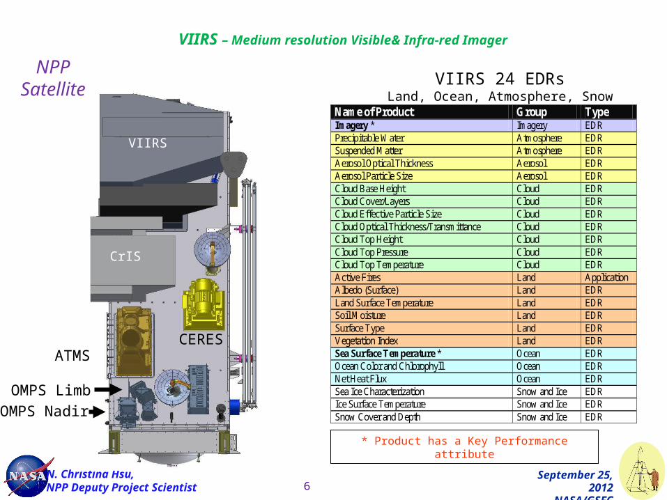
CERES
VIIRS
CrIS
ATMS
OMPS Limb
OMPS Nadir
VIIRS – Medium resolution Visible& Infra-red Imager
Name of Product Group Type Imagery * Imagery EDR Precipitable Water Atmosphere EDR Suspended Matter Atmosphere EDR Aerosol Optical Thickness Aerosol EDR Aerosol Particle Size Aerosol EDR Cloud Base Height Cloud EDR Cloud Cover/Layers Cloud EDR Cloud Effective Particle Size Cloud EDR Cloud Optical Thickness/Transmittance Cloud EDR Cloud Top Height Cloud EDR Cloud Top Pressure Cloud EDR Cloud Top Temperature Cloud EDR Active Fires Land Application Albedo (Surface) Land EDR Land Surface Temperature Land EDR Soil Moisture Land EDR Surface Type Land EDR Vegetation Index Land EDR Sea Surface Temperature * Ocean EDR Ocean Color and Chlorophyll Ocean EDR Net Heat Flux Ocean EDR Sea Ice Characterization Snow and Ice EDR Ice Surface Temperature Snow and Ice EDR Snow Cover and Depth Snow and Ice EDR
VIIRS 24 EDRsLand, Ocean, Atmosphere, Snow
* Product has a Key Performance attribute
NPP Satellite

VIIRS RGB image showing Smoke Plumes from New Mexico Fires
June 7, 2012

Smoke Plumes from New Mexico Fires June 7, 2012
Nighttime Light from NPP VIIRS Day-Night Band, June 5, 2012
Phoenix
Tucson El Paso
Albuquerque

Resolution Improvements: OLS vs. DNB
740 m instantaneous geometric field of view (DNB) from VIIRS vs. ~5 km for the OLS from DMSP results in dramatic spatial resolution improvements.
DNB Imagery courtesy of Steven Miller CIRA/CSU 9
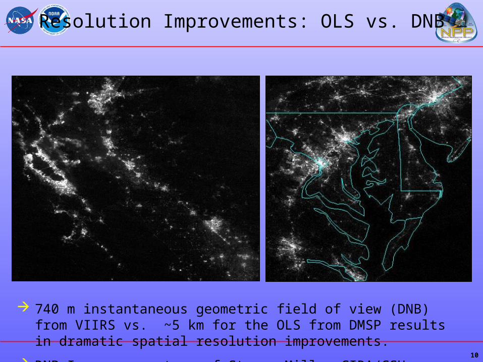
Resolution Improvements: OLS vs. DNB
10
740 m instantaneous geometric field of view (DNB) from VIIRS vs. ~5 km for the OLS from DMSP results in dramatic spatial resolution improvements.
DNB Imagery courtesy of Steven Miller CIRA/CSU

Continuing UV measurements from Aura/OMI to NPP/OMPS

12
1979 1982 1985 1988 1991 1994 1997 2000 2003 2006 2009 2012
SeaWiFS
MODIS/Terra
MODIS/Aqua
VIIRSNPP/JPSS
TOMS/Nimbus-7 TOMS/Earth Probe
TOMS/Nimbus-7: 11/1/1978 - 5/6/1993, Earth Probe 7/96 – 5/01
AVHRR: NOAA-series August 1981 – present
SeaWiFS: September 1997 – present
MODIS Terra: February 2000 – present
MODIS Aqua: July 2002 – present
NPP VIIRS: 2011 –
AVHRR/NOAA-series (7 and on)
Aerosol Data Record Time SeriesAerosol Data Record Time Series