1 unclassified – fouo – not for public release operational space environment network display...
TRANSCRIPT
1
UNCLASSIFIED – FOUO – Not for Public Release
UNCLASSIFIED – FOUO – Not for Public Release
Operational Space Environment Network Display (OpSEND) & the
Scintillation Network Decision Aid
Dr. Keith Groves, Prog MgrIonospheric Impacts to RF Systems
Space Vehicles DirectorateAir Force Research Laboratory
2
UNCLASSIFIED – FOUO – Not for Public Release
UNCLASSIFIED – FOUO – Not for Public Release
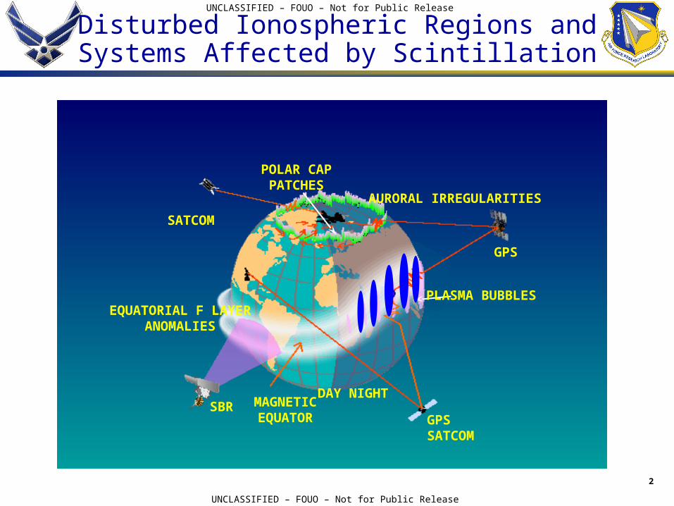
Disturbed Ionospheric Regions andSystems Affected by Scintillation
SATCOM
AURORAL IRREGULARITIES
GPS
PLASMA BUBBLES
GPS SATCOM
MAGNETICEQUATOR
DAY NIGHT
EQUATORIAL F LAYERANOMALIES
SBR
POLAR CAPPATCHES
3
UNCLASSIFIED – FOUO – Not for Public Release
UNCLASSIFIED – FOUO – Not for Public Release
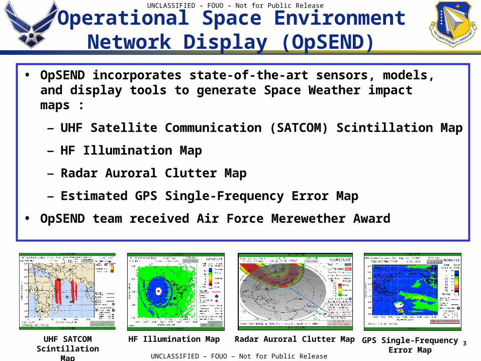
Operational Space Environment Network Display (OpSEND)
• OpSEND incorporates state-of-the-art sensors, models, and display tools to generate Space Weather impact maps :
– UHF Satellite Communication (SATCOM) Scintillation Map
– HF Illumination Map
– Radar Auroral Clutter Map
– Estimated GPS Single-Frequency Error Map
• OpSEND team received Air Force Merewether Award
UHF SATCOM Scintillation Map
GPS Single-Frequency Error Map
HF Illumination Map Radar Auroral Clutter Map
4
UNCLASSIFIED – FOUO – Not for Public Release
UNCLASSIFIED – FOUO – Not for Public Release
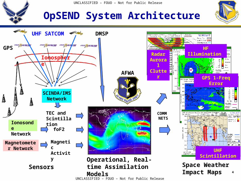
Radar Auroral Clutter
Ionosphere
GPS
UHF SATCOM
GPS 1-Freq Error
HF Illumination
COMM NETS
Ionosonde Network foF2
TEC and Scintillation
Magnetometer Network
DMSP
OpSEND System Architecture
UHF Scintillation
Operational, Real-time Assimilation Models
AFWA
Sensors Space Weather Impact Maps
Magnetic Activity
SCINDA/IMS Network
5
UNCLASSIFIED – FOUO – Not for Public Release
UNCLASSIFIED – FOUO – Not for Public Release
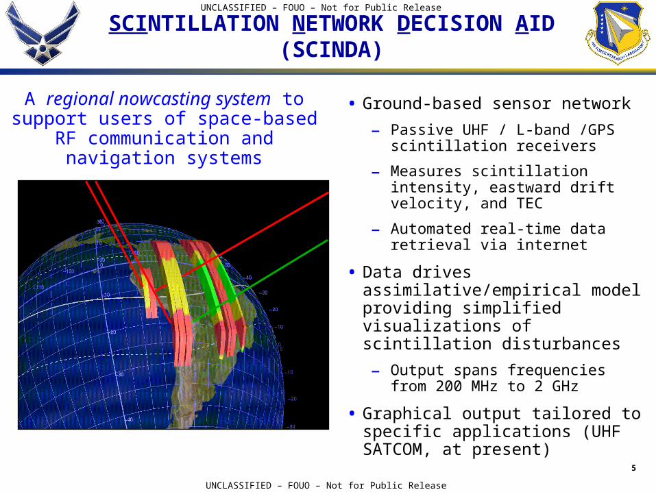
SCINTILLATION NETWORK DECISION AID(SCINDA)
• Ground-based sensor network
– Passive UHF / L-band /GPS scintillation receivers
– Measures scintillation intensity, eastward drift velocity, and TEC
– Automated real-time data retrieval via internet
• Data drives assimilative/empirical model providing simplified visualizations of scintillation disturbances
– Output spans frequencies from 200 MHz to 2 GHz
• Graphical output tailored to specific applications (UHF SATCOM, at present)
A regional nowcasting system to support users of space-based RF
communication and navigation systems
6
UNCLASSIFIED – FOUO – Not for Public Release
UNCLASSIFIED – FOUO – Not for Public Release
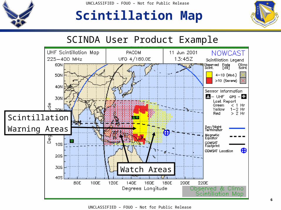
Scintillation Map
SCINDA User Product Example
Scintillation
Warning Areas
Watch Areas
7
UNCLASSIFIED – FOUO – Not for Public Release
UNCLASSIFIED – FOUO – Not for Public Release
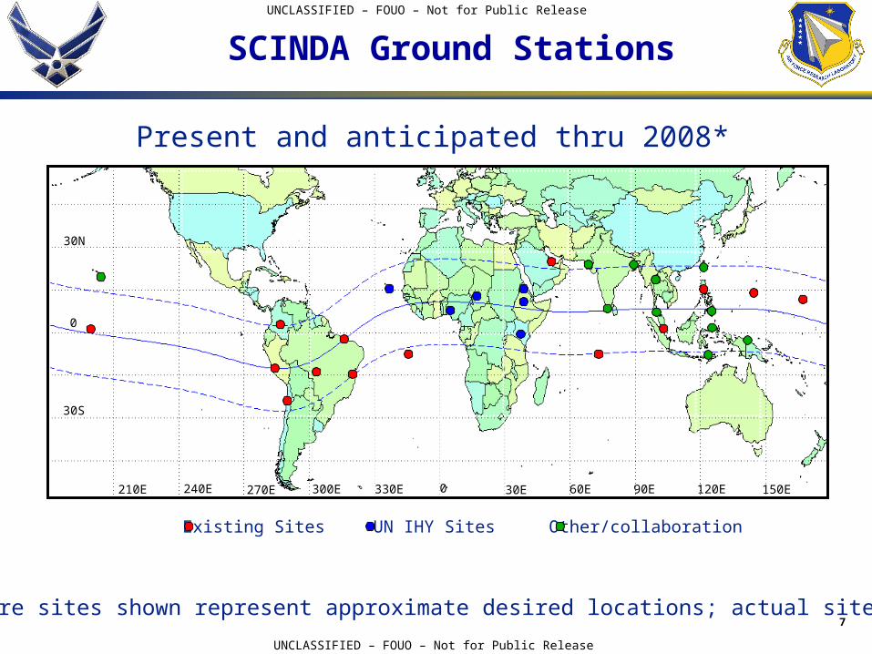
Present and anticipated thru 2008*
SCINDA Ground Stations
30N
0
30S
210E 240E 270E 300E 330E 0 30E 60E 90E 120E 150E
Existing Sites UN IHY Sites Other/collaboration
*Future sites shown represent approximate desired locations; actual sites TBD
8
UNCLASSIFIED – FOUO – Not for Public Release
UNCLASSIFIED – FOUO – Not for Public Release
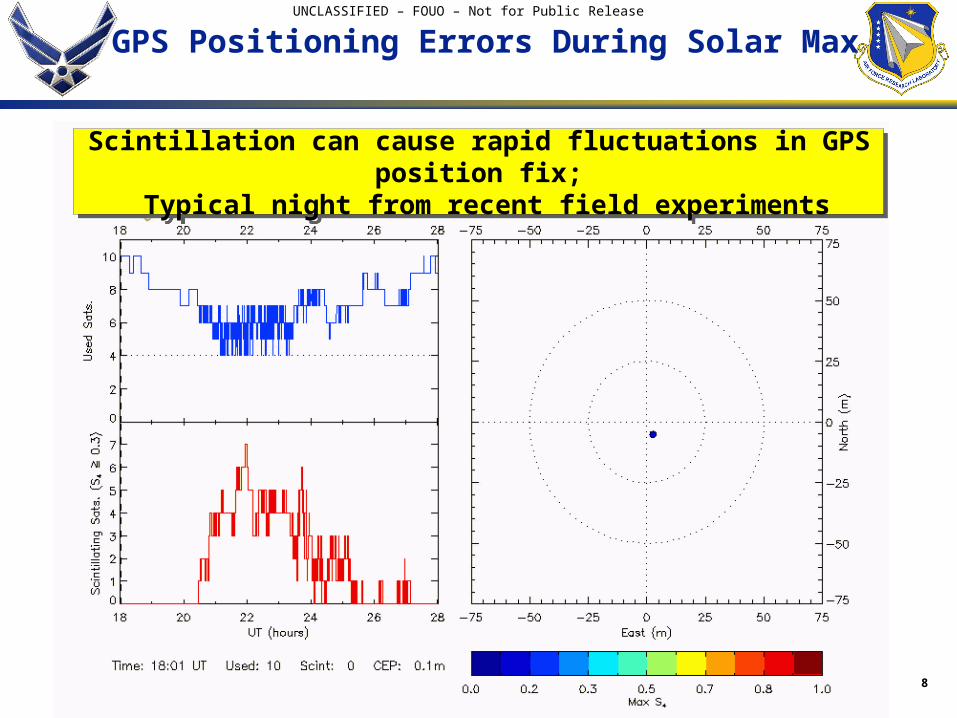
GPS Positioning Errors During Solar Max
Scintillation can cause rapid fluctuations in GPS position fix; Typical night from recent field experiments
Scintillation can cause rapid fluctuations in GPS position fix; Typical night from recent field experiments
9
UNCLASSIFIED – FOUO – Not for Public Release
UNCLASSIFIED – FOUO – Not for Public Release
Summary
• Ionospheric scintillation occurs routinely at low latitudes independent of magnetic activity
• Scintillation can affect the performance of space-based communication and navigation systems operating at frequencies below about 2 GHz
• Scintillation affects 2-frequency GPS systems, but no error-estimation model currently exists
• Exploiting collaborations with international partners and the UN, AFRL plans to add 10-15 new ground stations over the next three years
• Coordination with C/NOFS equatorial satellite planned to maximize scientific contribution to understanding Spread F
• Ground-station support leveraged across AFRL, AFOSR, AFWA and NSF
10
UNCLASSIFIED – FOUO – Not for Public Release
UNCLASSIFIED – FOUO – Not for Public Release
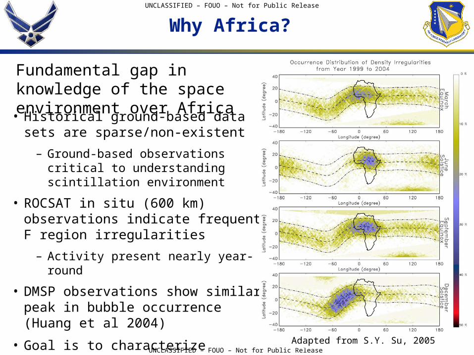
Why Africa?
• Historical ground-based data sets are sparse/non-existent
– Ground-based observations critical to understanding scintillation environment
• ROCSAT in situ (600 km) observations indicate frequent F region irregularities
– Activity present nearly year-round
• DMSP observations show similar peak in bubble occurrence (Huang et al 2004)
• Goal is to characterize irregularity development over Africa in the context of global patterns of scintillation occurrence
Adapted from S.Y. Su, 2005
Fundamental gap in knowledge of the space environment over Africa
11
UNCLASSIFIED – FOUO – Not for Public Release
UNCLASSIFIED – FOUO – Not for Public Release
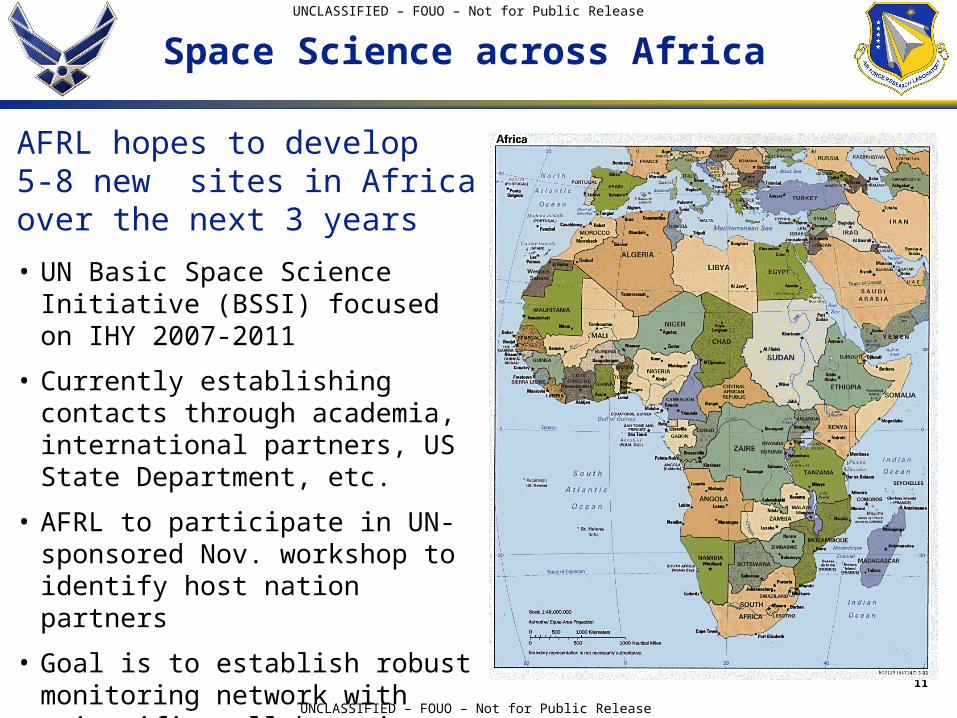
Space Science across Africa
• UN Basic Space Science Initiative (BSSI) focused on IHY 2007-2011
• Currently establishing contacts through academia, international partners, US State Department, etc.
• AFRL to participate in UN-sponsored Nov. workshop to identify host nation partners
• Goal is to establish robust monitoring network with scientific collaboration across Africa and Asia
AFRL hopes to develop 5-8 new sites in Africa over the next 3 years
12
UNCLASSIFIED – FOUO – Not for Public Release
UNCLASSIFIED – FOUO – Not for Public Release
SCINDA Ionospheric Parameter Measurements
• VHF (~250 MHz) & GPS scintillation parameters– S4 scintillation index
– Intensity spectrum
– Fading probability density function
– Temporal decorrelation of intensity
– Data quality flags based upon parameter consistency, and reconciliation between S4 index and the fading PDF
• Ionospheric zonal drift estimates obtained from VHF spaced antenna observations
• GPS Total Electron Content (TEC) and phase scintillation data
• Raw data (10-50 Hz) can be recorded as desired
Real-time output from SCINDA sensors includes: