1.0 project nexus - ycwa-relicensing.com studies/study 12-01... · licensee’s pre-application...
TRANSCRIPT

Yuba County Water Agency Yuba River Development Project
FERC Project No. 2246
August 2011 Revised Study Plan Historic Properties ©2011, Yuba County Water Agency Page 1 of 20
Study 12.1
HISTORIC PROPERTIES August 2011
1.0 Project Nexus Yuba County Water Agency’s (YCWA or Licensee) continued operation and maintenance (O&M) of the existing Yuba River Development Project (Project) has a potential to affect historic properties.1 YCWA will treat all information regarding the specific locations of cultural resource sites2, which include historic properties, as “Privileged and Confidential.” Without prior approval from the Federal Energy Regulatory Commission (FERC), the Global Positioning System (GPS) coordinates and maps showing the locations of such resources will not be made available to any Relicensing Participant other than FERC, State Historic Preservation Officer (SHPO), United States Department of Agriculture, Forest Service (Forest Service) for sites on National Forest System (NFS) land, and tribal chairs or designated tribal representatives of the participating tribes.
2.0 Resource Management Goals of Agencies with Jurisdiction Over the Resource to be Studied
Under Section 106 of the National Historic Preservation Act (NHPA) of 1966, as amended, federal agencies must take into account the effects of their undertakings on historic properties and afford the Advisory Council on Historic Preservation (ACHP) a reasonable opportunity to comment on such undertakings. As provided in 18 CFR § 5.5(e), on January 4, 2011, FERC, the lead federal agency for the licensing, designated YCWA as FERC’s non-federal representative for purposes of initiating consultation under Section 106 of the NHPA and the implementing regulations at 36 CFR § 800.2(c)(4). YCWA believes only one agency has jurisdiction over Historic Properties that could potentially be affected by Project-related activities, the United States Department of Agriculture, Forest Service on National Forest System (NFS) lands. In accordance with 36 CFR § 800.2(c)(3), “A representative of a local government with jurisdiction over the area in which the effects of an undertaking may occur is entitled to participate as a consulting party.” Additionally, direction for the management of the Plumas National Forest (PNF) is embodied in the PNF Land and Resource Management Plan (LMP) (USDA Forest Service, PNF 1988) as 1 As defined under 36 CFR 800.16(l), historic properties are prehistoric or historic sites, buildings, structures, objects, districts,
or locations of traditional use or beliefs that are included in, or eligible for inclusion in, the National Register of Historic Places (NRHP). Historic properties are identified through a process of evaluation against specific criteria. For most cultural resources evaluated for listing on the NRHP, these criteria are found at 36 CFR 60.4.
2 This study plan utilizes the term cultural sites to identify any prehistoric or historic district, site, building, structure, object, or Traditional Cultural Properties, regardless of its inclusion in or eligibility for inclusion in the National Register of Historic Places (NRHP).

Yuba County Water Agency Yuba River Development Project FERC Project No. 2246
Historic Properties Revised Study Plan August 2011 Page 2 of 20 ©2011, Yuba County Water Agency
amended by the Herger-Feinstein Quincy Library Group Record of Decision (USDA Forest Service, Pacific Southwest Region 1999) and the Sierra Nevada Forest Plan Amendment Record of Decision (SNFPA ROD) (USDA Forest Service, Pacific Southwest Region 2004). Similarly, direction for management of the Tahoe National Forest (TNF) is embodied in the TNF Land and Resource Management Plan (LMP) (USDA Forest Service, TNF 1990) as amended by the Herger-Feinstein Quincy Library Group Record of Decision (USDA Forest Service, Pacific Southwest Region 1999) and the Sierra Nevada Forest Plan Amendment Record of Decision (SNFPA ROD) (USDA Forest Service, Pacific Southwest Region 2004). Each of these land managing plans takes into account the effects of ground-disturbing activities on historic properties.
3.0 Study Goals and Objectives The goal of the study is to assist FERC in meeting its compliance requirements under Section 106 of the NHPA, as amended, by determining if licensing of the Project will have an adverse effect on historic properties. The objective of this study is to identify and assess Project effects on historic properties and potential historic properties that may be affected by Project O&M, and determining which of these resources requires NRHP-eligibility evaluations.
4.0 Existing Information and Need for Additional Information
Licensee’s Pre-Application Document (YCWA 2010) described existing, relevant, and reasonably available information regarding cultural resources. This information is summarized below. 4.1 Background Research To gather existing, relevant, and reasonably available information regarding cultural resources in the project vicinity, records searches were performed at State of California repositories in May and June 2009 at the North Central Information Center (NCIC) of the California Historical Resources Information System (CHRIS) at California State University, Sacramento (CSU, Sacramento) and the Northeast Information Center (NEIC) at California State University, Chico (CSU, Chico). The review of 96 previous cultural resources investigations and archival information indicates that lands in the FERC Project Boundary and within 0.25 mile of that boundary have been the subject of cultural resource investigations for over 40 years. YCWA estimates that the FERC Project Boundary contains 7,800 acres, of which approximately 4,700 acres (approximately 60%) are within the normal maximum water surface elevation of New Bullards Bar Reservoir. Based on existing and reasonably available information, all but about 2,200 acres of the area

Yuba County Water Agency Yuba River Development Project
FERC Project No. 2246
August 2011 Revised Study Plan Historic Properties ©2011, Yuba County Water Agency Page 3 of 20
within the FERC Project Boundary were previously surveyed for cultural resources. However, most of those studies are more than 10 years old and/or do not meet current professional standards for fieldwork. Table 4.1-1 lists all of the previous cultural resources investigations identified within the Project Data Gathering Area (e.g., the FERC Project Boundary and 0.25-mile study area surrounding the FERC Project Boundary).
Table 4.1-1. Previous cultural resources investigations within the Project Data Gathering Area. Author Date Title
NCIC/NEIC Report No.
County Quadrangle
Amesbury, Tom 1998 Milk Ranch Timber Harvest Plan NCIC-8412 Yuba Challenge
Andrews, Steven 2001 YWCA Fire Salvage Timber Harvest Plan NCIC-639 Yuba Challenge
Banka, William 2001 Pendola Ranch Timber Harvest Plan NCIC-8297 Yuba Camptonville
Beeson, Allison 1998 Middlebrook Timber Harvest Plan NCIC-789 Yuba French Corral
Bevill, Russell and Heath Browning
2006
Strawberry Etals Heritage Resource Inventory, Feather River Ranger District, Plumas National Forest, Plumas, Sierra, and Yuba Counties, California
NCIC-7537 Yuba Strawberry Valley
Bjorkman, Philip 1992 McClellan Middle Fork Timber Harvest Plan NCIC-7598 Nevada,
Yuba Camptonville
Boardman, Stan 1997 Chute Ravine Timber Harvest Plan NCIC-7859 Yuba Challenge, French Corral
Boudreauz, Daniel 2006 An Archaeological Survey Report for the Bullard Timber Harvesting Plan, Yuba County, California
NCIC-8591 Yuba Challenge
Bystry, Carl 1994 Henry Timber Harvest Plan NCIC-873 Yuba Challenge
Carr, Rick 2004 An Archaeological Survey Report for the Amendment Area on Section 27 Timber Harvesting Plan, Yuba County, California
NCIC-7146 Yuba Challenge
Cifelli, Chris 1977 Burnt Bridge Trail NCIC-881 Yuba Challenge
Compas, Lynn 2004
Cultural Resource Inventory for Pacific Gas and Electric's Proposed Colgate-Smartville #1 60 kV Transmission System Replacement Project, Yuba County, California
NCIC-7099 Yuba French Corral, Oregon
House, Smartville
Compas, Lynn and April Van Wyke
2007
Cultural Resources Inventory and National Register of Historic Places Evaluation of the Narrows Substation Transformer Bank Installation, Narrows Hydroelectric System (FERC No. 1403), Nevada County, California
NCIC-8665 Nevada Smartville
Davidson, Dario 1995 Lowman Timber Harvest Plan NEIC-3769 Sierra, Yuba
Pike and Camptonville
Davidson, Dario 1995 Lowman Timber Harvest Plan NCIC-8450 Yuba Camptonville
Davidson, Dario 1999 Bope Timber Harvest Plan NEIC-2733 Sierra Pike and Camptonville
Davidson, Dario 2002 Tanoak Timber Harvest Plan NCIC-8456 Tuba Strawberry Valley
Davidson, Dario 2002 59er Timber Harvest Plan NCIC-8318 Yuba Camptonville
Day, Donna 1983 Archaeological Reconnaissance Report - Short Form - Milk Ranch Mining Claim
NCIC-8441 Yuba Challenge
Day, Donna 1984 Archaeological Reconnaissance of the Race Track Mining Claim
NCIC-8388 Yuba Strawberry Valley
Day, Donna 1985 Cultural Resources Inventory Report for the Oregon Hill Timber Compartment
NCIC-8468 Yuba Challenge
Day, Hollis 1997 Bean Ranch Timber Harvest Plan NCIC-8566 Yuba Clipper Mills
Day, Hollis 1998 New Bullards Bar Timber Harvest Plan NCIC-827 Yuba Camptonville
Deal, Krista 1980 Archaeological Reconnaissance Report, Elbow Timber Sale
NCIC-5608 Yuba Camptonville
Dwyer, Erin and Elena Nilsson
2004 Heritage Resource Inventory of the Slapjack DFPZ, Plumas National Forest, California
NCIC-9297 Yuba Challenge, Clipper Mills,
Strawberry Valley Ferrier, Douglas 1995 Landsburg/Kerr Timber Harvest Plan NEIC-4865 Sierra Camptonville
Fogerty, J. 2002 Heritage Resources Inventory for the Lower Slate Defensible Fuel Profile Zone
NCIC-8406 Yuba Strawberry Valley
Frey, Richard 1991 Greenville Timber Harvest Plan NCIC-876 Yuba Challenge
Furlong, Steven 2005 An Archaeological Survey Report for the Steber Timber Harvesting Plan, Nevada County, California
NCIC-6653 Yuba Challenge

Yuba County Water Agency Yuba River Development Project FERC Project No. 2246
Historic Properties Revised Study Plan August 2011 Page 4 of 20 ©2011, Yuba County Water Agency
Table 4.1-1. (continued) Author Date Title
NCIC/NEIC Report No.
County Quadrangle
Furlong, Steve 2007 An Archaeological Survey Report for the Thompson Timber Harvesting Plan, Yuba County, California
NCIC-8733 Yuba Challenge
Gillett, Lucky 1994 Ruth Timber Harvest Plan NCIC-921 Yuba French Corral
Gillett, Lucky 1994 Slapjack Timber Harvest Plan NCIC-8562 Yuba Challenge
Gillett, Lucky 1995 Soroptomist Timber Harvest Plan NCIC-8458 Yuba Camptonville, Challenge
Gillett, Lucky 2000 Vierra II Timber Harvest Plan NCIC-7882 Yuba Challenge
Gillett, Lucky 2000 Celestial Valley Ditch Timber Harvest Plan NCIC-8308 Yuba Camptonville
O’Halloran, Molly 1992
Cultural Resource Inventory of the Oregon Insect Young Growth Special Salvage Timber Sale, Sierra County, Downieville Ranger District, Tahoe National Forest, Report Number 05-17-1005
NEIC-1388 Sierra, Yuba
Goodyear's Bar, Camptonville, Pike, Strawberry Valley
Helm, Wayne 1999 Little Oregon Creek/Fountain House Emergency Timber Salvage
NCIC-7096 Yuba Challenge
Henrie, LeAnn 1995 Cultural Resource Inventory for the Bullards Bar Underburn, Yuba County, Downieville Ranger District, Tahoe National Forest
NCIC-7632 Yuba Challenge
Humphreys, Stephen 1967 The Archaeology of the New Bullard's Bar Reservoir, Yuba County, California
NCIC-517 Yuba Camptonville
Jensen, Erik 2003 An Archaeological Survey Report for the Section 27 Timber Harvesting Plan, Yuba County, California
NCIC-7145 Yuba Challenge
Jensen, Erik 2006 An Archaeological Survey Report for the Section 28 CHY 80 Amendment, Yuba, California
NCIC-6928 Yuba Challenge
Johnson, James 1992 Burnt Ridge Timber Harvest Plan NCIC-7888 Yuba Challenge
Johnson, James 1994 Hauck/Dunston Timber Harvest Plan NCIC-8555 Yuba Challenge
Johnson, James 1995 Paredes Timber Harvest Plan NCIC-8575 Yuba Camptonville, Challenge
Johnson, James 1999 4-H Camp Timber Harvest Plan NCIC-8551 Yuba Challenge
Johnson, Jerald and Dorothea Theodoratus; Storm, Donald
1978; 1974
Cultural Resources of the Marysville Lake, California Project (Parks Bar Site), Yuba and Nevada Counties, California; An Archaeological Site Survey of Selected Portions of the Proposed Marysville Dam Project, Yuba River, California
NCIC-48 Yuba,
Nevada French Corral, Oregon
House, Smartville
Jones, Terry 1982
The North Yuba Survey: A Prehistoric Archaeological Survey of 14,000 acres in the Northern Sierra Nevada; also Archaeological Survey of the Hawkfly and the North Yuba Timber Compartments and the Pride Timber Sale
NCIC-804 Yuba, Sierra
Camptonville, Challenge, Clipper Mills, Strawberry
Valley
Jones and Stokes 2003 Cultural Resources Inventory and Evaluation Report for the Yuba-Feather Supplemental Flood Control Project, Yuba County, California
NCIC-6014 Yuba Challenge
Keenan, Kelly 2001 UC Field Station Vegetation Management Plan NCIC-2756 Yuba Oregon House, Smartville
Keye, William 1993 Toll House Timber Harvest Plan NCIC-8311 Yuba Camptonville
Kostick, Greg 1996 Vierra Timber Harvest Plan NCIC-7097 Yuba Challenge
Kostick, Greg 2000 Hewton Timber Harvest Plan NCIC-7630 Yuba Challenge
Kostick, Greg 2000 Patterson Timber Harvest Plan NCIC-7636 Yuba Challenge
Leach-Palm, Laura et al.
2008
Cultural Resources Inventory of Caltrans District 3 Rural Conventional Highways in Butte, Colusa, El Dorado, Glenn, Nevada, Placer, Sacramento, Sierra, Sutter, Yolo, and Yuba Counties
NCIC-9326 Yuba,
Nevada, Sierra
Camptonville
Leonhard, Scott 1996 Celestial Valley Timber Harvest Plan NCIC-8320 Yuba Camptonville
Leonhard, Scott 1997 Bullards Bar Timber Harvest Plan NCIC-650 Yuba Challenge, French Corral
Leonhard, Scott 1998 Pendola Timber Harvest Plan NCIC-7093 Yuba Challenge
Leonhard, Scott 2001 Shappert Timber Harvest Plan NCIC-8335 Yuba Camptonville
Levy, David 1992 Lacey-Kelly Timber Harvest Plan NCIC-841 Yuba Challenge
Long, Kelly 2005
An Archaeological Survey Report for the Fuel Reduction on Private Lands in the Forest Service Slapjack DFPZ - Middlebrook, A Proposition 40 Project, Yuba County, California
NCIC-6973 Yuba French Corral
Maniery, James and Mary Maniery
1997 Cultural Resources Inventory of the Soper-Wheeler Land Exchange, Plumas National Forest, California
NCIC-642 Yuba Challenge, Clipper Mills, French Corral, Strawberry
Valley

Yuba County Water Agency Yuba River Development Project
FERC Project No. 2246
August 2011 Revised Study Plan Historic Properties ©2011, Yuba County Water Agency Page 5 of 20
Table 4.1-1. (continued) Author Date Title
NCIC/NEIC Report No.
County Quadrangle
McCall, Dan 2001 Whitehead Timber Harvest Plan NCIC-7858 Yuba Challenge, Clipper Mills
McKillop, Ryan 1998 Empire Creek Timber Harvest Plan NCIC-7112 Yuba Clipper Mills McMorris, Christopher
2004 Caltrans Historic Bridges Inventory Update: Metal Truss, Movable, and Steel Arch Bridges
NCIC-6675 Yuba Camptonville
Meals, Hank 1979 Camptonville Station Parking Lot Expansion NCIC-8302 Yuba Camptonville
Newcomb, Alan 1996 Mumm Timber Harvest Plan NCIC-834 Yuba Camptonville
Newcomb, Alan 1997 Robert Mumm Timber Harvest Plan NCIC-2038 Yuba Camptonville
Origer, Thomas 1985 A Report on the Archaeological Reconnaissance of Pacific Gas and Electric Company's Camptonville Timber Sale Project, Yuba County, California
NCIC-456 Yuba Camptonville
Peak, Melinda 1988 Cultural Resources Assessment of the Colgate Tunnel Timber Sale Area, Yuba County, California
NCIC-8233 Yuba Challenge, French Corral
Rieger, Larry 1992 Browning Timber Harvest Plan NCIC-651 Yuba Camptonville
Rieger, Larry 1994 Colgate-Challenge T/L Timber Harvest Plan NCIC-8558 Yuba French Corral
Rogers, Terry 1998 Ingersoll-Dobbins Timber Harvest Plan NCIC-7852 Yuba French Corral
Rogers, Terry 1999 Grizzly Gulch Timber Harvest Plan NEIC-2727 Sierra Camptonville
Smith , Douglas 1997 Pendola Ranch Timber Harvest Plan - Additional Harvest Acres
NCIC-1129 Yuba Camptonville
Smith , Douglas 1999 Pendola Ranch Timber Harvest Plan - Additional Harvest Acres
NCIC-1130 Yuba Camptonville
Stevens, Dennis 1995
Cultural Resource Inventory of the Bullards Bar Water System Replacement, Yuba County, Downieville Ranger District, Tahoe National Forest, Report Number 05-17-1145
NCIC-7646 Yuba Challenge
Stevens, Dennis 1993 Cultural Resources Inventory of the Oregon Creek Analysis Area, Yuba and Sierra Counties, Downieville Ranger District, Tahoe National Forest
NCIC-8446 Yuba Camptonville
Stevens, Dennis 1994
Cultural Resources Inventory of the Oregon Creek Analysis Area, Yuba and Sierra Counties, Downieville Ranger District, Tahoe National Forest (Addendum 1)
NCIC-8447 Yuba Camptonville
Stevens, Dennis 1997 Jaybird Timber Sale NCIC-8403 Yuba Camptonville, Strawberry
Valley
Stevens, Dennis 1997 Schoolhouse, Dark Day and Hornswoggle Campgrounds Rebuild Archaeological Report
NCIC-8439 Yuba Camptonville
Stevens, Dennis 1997 Moran Road Turnaround and Dark Day Parking Lot Expansion Archaeological Report
NCIC-8459 Yuba Camptonville, Challenge
Stevens, Dennis 1982 Mosquito Timber Sale Archaeological Reconnaissance Report
NCIC-8460 Yuba Camptonville, Challenge
Stevens, Dennis 1988 Skyline Compartment Timber Sale NCIC-8457 Yuba Camptonville, Challenge
Storm, Donald 1980 Cultural Resource Investigation of the Ingersoll Subdivision Tracts 200, 222, and 224, near Dobbins, Yuba County, California
NCIC-596 Yuba French Corral
Violett, Paul 1992 Gellerman Timber Harvest Plan NCIC-8559 Yuba Challenge, French Corral
Walden, Peter 2000 Burnett Timber Harvest Plan NCIC-8552 Yuba Challenge
Wayland, Brian 1999 Summit Hill Ranch Timber Harvest Plan NCIC-7640 Yuba Challenge Werner, Roger and Jay Flaherty
1981 Marysville Road Cultural Resources Investigation NCIC-908 Yuba Camptonville
Werner, Roger H. and Flaherty, Jay M.
1981 Ridge Road Cultural Resources Investigation NEIC-1177 Sierra Camptonville
Werner, Roger and Julia Costello
1984 Archaeological Reconnaissance of the Deadwood Creek Water Power Project
NCIC-8401 Yuba Strawberry Valley
Wheeler, Thomas 1980 Marysville Road Improvement Archaeological Report
NCIC-8438 Yuba Camptonville
Wheeler, Thomas and Dan Stevens
1980 Studhorse Road Relocation Project Archaeological Survey
NCIC-8434 Yuba Camptonville
Whittlesey, Nicholas 2001 Soroptomist II Timber Harvest Plan NCIC-2757 Yuba Camptonville, Challenge
Wiant, Wayne 1988 Addendum-Archaeological Reconnaissance of the Proposed New Diversion and Access Road Locations for the Deadwood Creek Water Power Project
NCIC-1005 Yuba Strawberry Valley
Windward, Stephen 2002 Oregon Hill Timber Harvest Plan NCIC-7638 Yuba Challenge

Yuba County Water Agency Yuba River Development Project FERC Project No. 2246
Historic Properties Revised Study Plan August 2011 Page 6 of 20 ©2011, Yuba County Water Agency
Table 4.1-1. (continued) Author Date Title
NCIC/NEIC Report No.
County Quadrangle
Wise, David 1999 Jones Timber Harvest Plan NCIC-1982 Yuba Challenge NCIC = North Central Information Center NEIC= Northeast Information Center
For those portions of the Project located within Yuba and Nevada counties, YCWA identified a total of 149 previously recorded cultural resources on file at the NCIC. Of these, 24 sites lie inside the FERC Project Boundary and the remaining 125 sites are within the 0.25-mile study area surrounding the FERC Project Boundary. No previously recorded sites were identified for the Sierra County portion of the Project. The 24 sites within the FERC Project Boundary are listed in Table 4.1-2. Table 4.1-2. Previously recorded cultural resources within the FERC Project Boundary.
# Trinomial Primary
No.
Tahoe National Forest Service
No. Recorder/Date1
Site Type2
Brief Description
NRHP Eligibility3
1 CA-YUB-0018 P-58-0036 None Riddell/1966 P
Bedrock mortars (x7) and midden deposits; author recommended testing; currently inundated
Not evaluated
2 CA-YUB-0019 P-58-0037 None Riddell/1966 P
Bedrock mortars (x5) and midden deposits; author recommended no further work; currently inundated
Not evaluated
3 CA-YUB-0020 P-58-0038 None Riddell/1966 P
Single depression, possible housepit; no author recommendation indicated; currently inundated
Not evaluated
4 CA-YUB-0021 P-58-0039 None Riddell/1966 P
Bedrock mortars (x51) and village, several areas were indicative of house pits; lithic material; excavated and reported by Humphreys (1967); currently inundated
Not evaluated
5 CA-YUB-0022 P-58-0040 None Olsen/1966 P
Bedrock mortars (number not indicated); author recommended no further work; currently inundated
Not evaluated
6 CA-YUB-0023 P-58-0041 None Olsen/1966 P Bedrock mortars (x5); author recommended no further work; currently inundated
Not evaluated
7 CA-YUB-0024 P-58-0042 None Riddell/1966 P
Bedrock mortars (x13) and midden deposits; author recommended testing; currently inundated
Not evaluated
8 CA-YUB-
0025/H P-58-0043 None Riddell/1966 P/H
Bedrock mortars (x18) and midden deposits; possible prehistoric camp site; historic-period stage stop; author recommended excavation; currently inundated
Not evaluated
9 CA-YUB-
0026/H P-58-0044 None Riddell/1966 P/H
Lithic scatter; historic-period farm buildings one site; author recommended no further work; currently inundated
Not evaluated
10 CA-YUB-0868 P-58-0886 None Storm/1977 P
Bedrock mortars (x15) and pestles (x4); briefly exposed during survey (normally inundated by New Bullards Bar Reservoir)
Not evaluated

Yuba County Water Agency Yuba River Development Project
FERC Project No. 2246
August 2011 Revised Study Plan Historic Properties ©2011, Yuba County Water Agency Page 7 of 20
Table 4.1-2. (continued)
# Trinomial Primary
No.
Tahoe National Forest Service
No. Recorder/Date1
Site Type2
Brief Description
NRHP Eligibility3
11 CA-YUB-0887 P-58-0905 None Deen/1977 P
Bedrock mortars (x2); briefly exposed during survey (normally inundated by New Bullards Bar Reservoir)
Not evaluated
12 CA-YUB-0894 P-58-0912 None Storm/1977, Flaherty and Werner/1984
P Bedrock mortars (at least 6) Not evaluated
13 CA-YUB-1054 P-58-1072 05-17-53-00072 Budy/1976 P
Single depression, tool fragments, lithic debris; briefly exposed during survey (normally inundated by New Bullards Bar Reservoir)
Not evaluated
14 CA-YUB-1217 P-58-1236 None Peak/1988 P Bedrock mortars (x2) and mano fragments (x2)
Not evaluated
15 CA-YUB-1574 P-58-1918 None Flaherty and Werner/1984
P Bedrock mortars (x3) Not evaluated
16 None P-58-1532 None Wayland/1999 H Former Summit Hill Ranch, a late 1950s construction
Not evaluated
17 None P-58-1579 None Boardman/
1997 P Bedrock mortars (x7) Not evaluated
18 None P-58-1947 None Moine/1998 H Road bed, possible section of Ramm’s Toll Road
Not evaluated
19 None None 05-17-53-00102 Unknown U Unknown2 site description. Unknown
20 None None 05-17-53-00126 Unknown U Unknown2 site description. Site may be inundated.
Unknown
21 None None 05-17-53-00127 Unknown U Unknown2 site description. Site may be inundated.
Unknown
22 None None 05-17-53-00139 Unknown U Unknown2 site description. May include/encompass site P-58-0294, located outside the APE.
Unknown
23 None None 05-17-53-00254 Unknown U
Unknown2 site description;
located on end of project road and needs confirmation that site is in APE.
Unknown
24 None None 05-17-53-00340 Unknown U Unknown2 site description. Site may be inundated.
Unknown 1Unknown: Names of recorders and dates of records were not available during initial records search and will researched during archival
research; 2Site Type: P = Prehistoric, H = Historic; P/H = Both Prehistoric and Historic; U = Unknown site contents; 3Unknown: Mapped site locations only available during initial records search; associated site records to be collected during archival research.
The majority of historic period site assemblages reflect industrial mining and domestic occupations of the project vicinity; almost one-third of the historic period sites contain mining-related features. Historic infrastructure features, predominantly ditches and roads, were also identified. Native American pre-contact sites are typical of those found throughout the region, namely locations with bedrock milling features and scatters of lithic material. Other documented pre-contact cultural remains range from an isolated projectile point to evidence of long-term occupations evinced by midden deposits, possible house pits, and other domestic features. Many previously identified cultural resources were not evaluated for eligibility for inclusion in the NRHP. Approximately 70 percent of the surveys occurred 10 or more years ago, provide insufficient information to determine the adequacy of the coverage employed, or report methods that indicate the survey coverage was broad or otherwise did not fully cover the areas included in those projects.
Yuba County Water Agency Yuba River Development Project FERC Project No. 2246
Historic Properties Revised Study Plan August 2011 Page 8 of 20 ©2011, Yuba County Water Agency
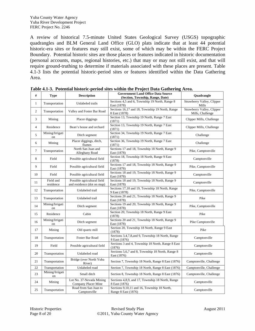
A review of historical 7.5-minute United States Geological Survey (USGS) topographic quadrangles and BLM General Land Office (GLO) plats indicate that at least 44 potential historic-era sites or features may still exist, some of which may be within the FERC Project Boundary. Potential historic sites are those places or features indicated in historic documentation (personal accounts, maps, regional histories, etc.) that may or may not still exist, and that will require ground-truthing to determine if materials associated with these places are present. Table 4.1-3 lists the potential historic-period sites or features identified within the Data Gathering Area. Table 4.1-3. Potential historic-period sites within the Project Data Gathering Area.
# Type Description Government Land Office Data Source
(Section, Township, Range, Date) Quadrangle
1 Transportation Unlabeled trails Sections 4,5 and 6, Township 19 North, Range 8 East (1878)
Strawberry Valley, Clipper Mills
2 Transportation Valley and Foster Bar Road Sections 16,17 and 18, Township 19 North, Range 8 East (1878)
Strawberry Valley, Clipper Mills, Challenge
3 Mining Placer diggings Section 13, Township 19 North, Range 7 East (1871)
Clipper Mills, Challenge
4 Residence Bean’s house and orchard Section 13, Township 19 North, Range 7 East (1871)
Clipper Mills, Challenge
5 Mining/Irrigati
on Ditch segment
Section 34, Township 19 North, Range 7 East (1871)
Challenge
6 Mining Placer diggings, ditch,
flumes Section 36, Township 19 North, Range 7 East (1871)
Challenge
7 Transportation North San Juan and
Alleghany Road Sections 17 and 18, Township 18 North, Range 9 East (1878)
Pike, Camptonville
8 Field Possible agricultural field Section 18, Township 18 North, Range 9 East (1878)
Camptonville
9 Field Possible agricultural field Sections 17 and 18, Township 18 North, Range 9 East (1878)
Pike, Camptonville
10 Field Possible agricultural field Sections 18 and 19, Township 18 North, Range 9 East (1878)
Camptonville
11 Field and residence
Possible agricultural field and residence (dot on map)
Sections 18 and 19, Township 18 North, Range 9 East (1878)
Camptonville
12 Transportation Unlabeled trail Sections 17,18 and 19, Township 18 North, Range 9 East (1878)
Pike, Camptonville
13 Transportation Unlabeled trail Sections 20 and 21, Township 18 North, Range 9 East (1878)
Pike
14 Mining/Irrigati
on Ditch segment
Sections 19 and 20, Township 18 North, Range 9 East (1878)
Pike, Camptonville
15 Residence Cabin Section 20, Township 18 North, Range 9 East (1878)
Pike
16 Mining/Irrigati
on Ditch segment
Sections 20 and 21, Township 18 North, Range 9 East (1878)
Pike Camptonville
17 Mining Old quartz mill Section 20, Township 18 North, Range 9 East (1878)
Pike
18 Transportation Foster Bar Road Sections 3,4,7,8,and 9, Township 18 North, Range 8 East (1876)
Camptonville
19 Field Possible agricultural field Sections 3 and 4, Township 18 North, Range 8 East (1876)
Camptonville
20 Transportation Unlabeled road Sections 5,6,7 and 8, Township 18 North, Range 8 East (1876)
Camptonville
21 Transportation Bridge (over North Yuba
River) Section 7, Township 18 North, Range 8 East (1876) Camptonville, Challenge
22 Transportation Unlabeled road Section 7, Township 18 North, Range 8 East (1876) Camptonville, Challenge
23 Mining/Irrigati
on Small ditch Section 8, Township 18 North, Range 8 East (1876) Camptonville, Challenge
24 Mining Lot No. 37-Nevada Mining
Company Placer Mine Sections 4,8,9, and 17, Township 18 North, Range 8 East (1876)
Camptonville
25 Transportation Road from San Juan to
Camptonville Sections 9,10,11 and 16, Township 18 North, Range 8 East (1876)
Camptonville

Yuba County Water Agency Yuba River Development Project
FERC Project No. 2246
August 2011 Revised Study Plan Historic Properties ©2011, Yuba County Water Agency Page 9 of 20
Table 4.1-3. (continued) # Type Description
Government Land Office Data Source (Section, Township, Range, Date)
Quadrangle
26 Transportation Unlabeled road Sections 10 and 11, Township 18 North, Range 8 East (1876)
Camptonville
27 Mining Old gold diggings Section 11, Township 18 North, Range 8 East (1876)
Camptonville
28 Transportation “Old Road” and road
segments Section 13, Township 18 North, Range 8 East (1876)
Camptonville
29 Transportation “Old Road” segment Section 14, Township 18 North, Range 8 East (1876)
Camptonville
30 Transportation “Old Road” segment Sections 10 and 15, Township 18 North, Range 8 East (1876)
Camptonville
31 Transportation Unlabeled road Sections 16 and 17, Township 18 North, Range 8 East (1876)
Camptonville
32 Field Possible agricultural field Sections 17 and 20, Township 18 North, Range 8 East (1876)
Camptonville
33 Transportation Unlabeled road segments Sections 17,19 and 20, Township 18 North, Range 8 East (1876)
Camptonville, Challenge
34 Mining/Irrigati
on Ditch
Sections 19, 20 and 29, Township 18 North, Range 8 East (1876)
Camptonville, Challenge
35 Transportation Unlabeled road Sections 29 and 30, Township 18 North, Range 8 East (1876)
Camptonville, Challenge
36 Transportation Unlabeled trail Section 30, Township 18 North, Range 8 East (1876)
Camptonville, Challenge
37 Transportation Unlabeled road segments Sections 1, 2, 3 and 12, Township 18 North, Range 7 East (1878)
Challenge
38 Agriculture McConnell’s Orchard Sections 2 and 3, Township 18 North, Range 7 East (1878)
Challenge
39 Transportation Unlabeled road Sections 11, 13 and 14, Township 18 North, Range 7 East (1878)
Challenge
40 Transportation Romb’s Bridge Section 13, Township 18 North, Range 7 East (1878)
Challenge
41 Field Possible agricultural field Section 24, Township 18 North, Range 7 East (1878)
Challenge
42 Transportation
Unlabeled trail (connects with trail in Section 30,
Township 18 North, Range 8 East)
Section 25, Township 18 North, Range 7 East (1878)
Challenge
43 Transportation Bullard’s Bar Road Sections 2,3, and 4, Township 17 North, Range 7 East (1874)
French Corral
44 Transportation Road to San Juan Section 23, Township 16 North, Range 6 East (1876)
Smartville1
1 In 2008, the people of this community petitioned to have the name changed to Smartsville, with an ‘s’ in the middle of the name. However, the USGS gage refers to the former spelling of the community name. Therefore in this document, the community is referred to as such.
5.0 Study Methods and Analysis 5.1 Study Area The study area is the Area of Potential Effects (APE), which includes all lands, Project facilities and features within the existing FERC Project Boundary, and Project-affected locations outside the FERC Project Boundary. As defined in 36 CFR § 800.16(d), an APE is:
the geographic area or areas within which an undertaking may directly or indirectly cause alterations in the character or use of historic properties, if any such properties exist. The area of potential effects is influenced by the

Yuba County Water Agency Yuba River Development Project FERC Project No. 2246
Historic Properties Revised Study Plan August 2011 Page 10 of 20 ©2011, Yuba County Water Agency
scale and nature of an undertaking and may be different for different kinds of effects caused by the undertaking.
For purposes of this relicensing, the APE includes all lands within the existing FERC Project Boundary and a buffer of about 200 feet surrounding the boundary of New Bullards Bar Reservoir. The FERC Project Boundary and APE are shown on the maps included in Attachment A. Land ownership within the APE includes 4,306 acres of National Forest Systems (NFS) land managed by the United States Department of Agriculture, Forest Service as the Tahoe National Forest (3,140 acres) and Plumas National Forest (1,165 acres). Acreage within the APE and FERC Project Boundary is listed below in Table 5.1-1 by landowner and total acreage for each Project facility. Table 5.1-1. Distribution of Project acreage by landownership and Project facility
YRDP1 Project Facility
YCWA1 SPI1 Private 1
(other) TNF1 PNF1 USACE1 State
New Colgate2 - Nevada Co. 0 0 1.0 30.6 0 0 0
New Colgate – Yuba Co. 3,249.6 39.2 117.9 3,062.7 1,165.6 0 0 New Colgate – Sierra Co. 0 26.9 23.6 47.4 0 0 0
Acreage Subtotal 3,243.8 26.9 148.1 0 0 0 0 Narrows No. 23 –Nevada Co. 0 0 0.1 0 0 0 0 Narrows No. 2 – Yuba Co. 1.0 0 3.3 0 0 16.0 20.0 Narrows No. 2 – Sierra Co. 0 0 0 0 0 0 0
Acreage Subtotal 1.0 0 3.3 0 0 16.0 20.0 Total 3,250.6 66.2 3.3 3,140.7 1,165.6 16.0 20.0
1 YRDP = Yuba River Development Project; YCWA = Yuba County Water Agency; SPI = Sierra Pacific Industries; Private/Other = Private residence or other private landholding; TNF = Tahoe National Forest; PNF = Plumas National Forest; USACOE = U.S. Army Corps of Engineers;
2 New Colgate Facility includes New Bullards Bar Reservoir, New Bullards Bar Dam and Spillway, Our House Diversion Dam, Log Cabin Diversion Dam, New Colgate Powerhouse, Penstock, and Switchyard, and Access Roads within the FERC Project Boundary.
3 Narrows No. 2 Facility = Narrows No. 2 Powerhouse, Penstock, Switchyard, and Access Road within the FERC Project Boundary
YCWA will coordinate with tribes and agencies to identify whether there are known tribal or other cultural resources concerns outside the FERC Project Boundary for which there is a Project nexus, and consult with SHPO to seek concurrence on the APE as early as possible in the relicensing process. If YCWA proposes an addition to the Project, the APE will be expanded if necessary to include areas potentially affected by the addition. 5.2 General Concepts and Procedures The following general concepts and practices apply to the study: Personal safety is the most important consideration of each fieldwork team.
Licensee will make a good faith effort to obtain permission to access private property where needed well in advance of entering the property.
Field crews may make minor variances to the FERC-approved study in the field to accommodate actual field conditions and unforeseen problems. When minor variances are made, Licensee’s field crew will follow the protocols in the FERC-approved study.

Yuba County Water Agency Yuba River Development Project
FERC Project No. 2246
August 2011 Revised Study Plan Historic Properties ©2011, Yuba County Water Agency Page 11 of 20
When Licensee becomes aware of major variances to the FERC-approved study, Licensee will issue an e-mail to the Relicensing Contact List describing the variance and reason for the variance. Licensee will contact by phone the Forest Service (if the variance is on National Forest System land), USFWS, SWRCB and CDFG to provide an opportunity for input regarding how to address the variance. Licensee will issue an e-mail to the Relicensing Contact List advising them of the resolution of the variance. Licensee will summarize in the final study report all variances and resolutions.
Licensee’s performance of the study does not presume that Licensee is responsible in whole or in part for measures that may arise from the study.
Global Positioning System (GPS) data will be collected using a Survey Grade Trimble GPS (sub-meter data collection accuracy under ideal conditions), or similar unit. GPS data will be post-processed and exported from the GPS unit into Geographic Information System (GIS) compatible file format in an appropriate coordinate system using desktop software. The resulting GIS file will then be reviewed by both field staff and Licensee’s relicensing GIS analyst. Metadata will be developed for deliverable GIS data sets.
5.3 Study Methods The study methods will consist of the following five steps, each of which is described below. 5.3.1 Step 1 – Obtain SHPO Approval of APE As required under Section 106 [36 CFR § 800.4(a)(1)], YCWA will submit maps depicting the APE to the SHPO for formal review, comment, and concurrence as early in the relicensing process as practicable, following the final definition of the APE. Once approved, the maps and SHPO’s concurrence letter will be filed with FERC. YCWA will include in the SHPO correspondence the Cultural Resources Specialists for TNF and PNF and interested tribes, if requested. YCWA may request that SHPO concur with a modified APE during the study if YCWA determines that the Project affects historic properties outside the previously SHPO-approved APE. 5.3.2 Step 2 – Archival Research Information has been obtained from the record searches that identified previous cultural surveys and recorded archaeological and historic-era properties within or directly adjacent to the APE. Archival research will also be conducted at the repositories listed below, and others as they are identified during the study, to obtain additional information specific to the prehistory and history of the Project area, the hydroelectric system as a whole, and its individual features. The results of the archival research will serve as the basis for preparing the prehistoric and historic contexts against which archaeological and historic-era properties may be evaluated. Historical photographs located during the archival research will be cited in the text as figures and provided in a separate appendix, unless they are subject to copyright laws. Previous NRHP evaluations of Project system

Yuba County Water Agency Yuba River Development Project FERC Project No. 2246
Historic Properties Revised Study Plan August 2011 Page 12 of 20 ©2011, Yuba County Water Agency
features, if they exist, will be used as much as possible. The places to be contacted or visited shall include: Oral histories, as applicable United States Department of Agriculture (USDA) Forest Service, Tahoe National Forest USDA Forest Service, Plumas National Forest Yuba County Library California Room, Marysville The Firehouse Museum, Nevada City Sacramento History Center and Archives State Library, Sacramento Camptonville Historical Society YCWA archives Special Collections, Meriam Library, California State University, Chico United States Army Corps of Engineers (USACE) for Englebright Reservoir Area
5.3.2 Step 3 – Field Survey and Identification of Resources FERC is required to make a reasonable and good faith effort to identify historic properties that may be affected by the Project. As described at 36 CFR § 800.4(b)(1), this may be accomplished through field surveys that are implemented in accordance with the Secretary of the Interior’s Standards and Guidelines for Identification (NPS 1983). FERC is also required to consider any other applicable professional standards and tribal, state, or local laws or procedures to complete the identification of historic properties. 5.3.2.1 Archaeological Field Survey Following completion of Step 2, YCWA will conduct a field survey to verify locations of previously recorded cultural resources and to identify previously unknown cultural resources, if present. This will be completed by examining all accessible lands within the APE. Areas within the APE that cannot be accessed in a safe manner (e.g., certain locations containing dense vegetation, or unsafe slopes) will not be included within the survey or recording of archaeological and historic-era properties; these areas will be identified in the resulting report and an explanation for survey exclusion will be provided. Field methods will include crew members walking parallel transects spaced 15-20 meters apart. In areas containing moderately dense vegetation or moderately steep terrain, the survey strategy may employ 20–40-meter transects. All topographical features encountered in moderate areas, and considered to be sensitive for cultural resources (i.e., springs, drainages, etc.) will be thoroughly inspected. Lands typically inundated by New Bullards Bar Reservoir that become accessible during the survey season as a result of normal reservoir draw-downs also will be examined. To accommodate low water levels, the field survey of the reservoir will be scheduled to occur as close to the periods of annual low reservoir levels as possible, depending on weather conditions. Additionally, each site identified in the APE will be assessed for Project-related effects including, but not limited to, water fluctuation, wave action, and vegetation management activities.

Yuba County Water Agency Yuba River Development Project
FERC Project No. 2246
August 2011 Revised Study Plan Historic Properties ©2011, Yuba County Water Agency Page 13 of 20
The field survey will be supervised by qualified, professional archaeologists (i.e., individuals who meet the Secretary of the Interior’s Standards for professional archaeologists). Tribes will be invited to submit resumes of qualified tribal members to participate in the field survey. The field survey will be used to examine all lands within the APE that can safely be accessed and will follow the Secretary of the Interior’s Standards and Guidelines for Archaeology and Historic Preservation (NPS 1983) to determine whether historic properties will be affected by the relicensing. Locations of previously recorded cultural resources will be verified and the sites re-recorded only if their existing site records or other documentation do not meet current standards for recording, or if the condition and/or integrity of the property has changed since its previous recording. Newly discovered cultural resources, including isolated finds, will be fully documented following the recordation procedures outlined in Instructions for Recording Historical Resources (OHP 1995), which utilizes State of California, Department of Parks and Recreation (DPR) forms DPR 523 A-L. A sketch map for each site recorded or re-documented will be drawn to-scale and the property photographed. The locations of all archaeological sites and isolates documented during the survey will be plotted by YCWA’s cultural resources specialist or cultural consultant onto the appropriate USGS 1:24,000 scale topographic map at the time of discovery. Field personnel will use a GPS receiver to document the location of cultural resources (including isolates) discovered during the survey, which will be plotted onto the appropriate USGS topographic quadrangle using the UTM coordinate system. GPS data related to recordation of historic properties will adhere to DPR specifications for accuracy and site specific procedures, and with the General Concepts and Procedures provided above in Section 5.2. Additionally, the areas examined will be plotted onto the appropriate USGS 7.5-minute topographic quadrangle for comparison with previous survey coverage maps. Archaeological surveys that occur on Forest Service lands will require special use permits. As requested by TNF, artifacts encountered during the field survey on the TNF will be left in place; no artifacts on TNF will be collected during the field survey. As requested by the PNF, time-sensitive diagnostic artifacts encountered during the field work will be collected and submitted to PNF following completion of the study. All diagnostic artifacts encountered will be documented on DPR Primary Records, their positions mapped using a GPS unit, and each artifact photographed using a digital photography format. YCWA will schedule the field survey within New Bullards Bar Reservoir (i.e., within the normal maximum water surface elevation), to the extent surveys within the reservoir can be performed, for fall or winter, weather permitting, when annual water levels are at their lowest, as shown in Figure 5.3-1. Surveys outside the New Bullards Bar Reservoir pool will be scheduled by YCWA at its convenience.

Yuba County Water Agency Yuba River Development Project FERC Project No. 2246
Historic Properties Revised Study Plan August 2011 Page 14 of 20 ©2011, Yuba County Water Agency
Figure 5.3-1. Historic annual reservoir levels at New Bullards Bar Reservoir. 5.3.2.2 Historic-Era Inventory of Project System Features A field inspection, documentation, and subsequent NRHP evaluation (see below) of the entire Project system will be undertaken by qualified, professional individuals meeting the Secretary of the Interior Standards for Architectural and Engineering Documentation. Individual components will be recorded or re-recorded to meet current DPR standards. This will include digital color photography and sketch maps of individual features that show the relationship of buildings within each compound or camp that may be associated with them. Some or all features comprising the hydroelectric system may not have reached 50 years of age at the time of the field survey. However, the entire Project system will be documented and evaluated for listing on the NRHP because the system will soon reach 50 years of age and because it may be associated with one or more of the four criteria, defined in 36 CFR 60.4, which may result in an eligibility finding that supercedes the age criterion. 5.3.2.3 Discovery and Treatment of Human Remains If human remains are discovered during the field survey, the field supervisor will immediately contact YCWA and Forest Service cultural resources specialists, as appropriate. Should human remains be identified during the survey, or any phase of work under this plan, all work in the immediate area will cease and the provisions contained within federal and/or State law and ACHP policy (ACHP 2007) will be followed. In addition to compliance with federal and State law, contacts with local Native American tribes, archaeological contractors, physical anthropologists, YCWA system operators, Forest Service; and, in some cases, the SHPO may be involved. Moreover, human remains and associated funerary objects, if any, often are viewed as sacred and must be treated with respect. Sensitivity toward all interested parties also is essential whenever human remains are concerned.

Yuba County Water Agency Yuba River Development Project
FERC Project No. 2246
August 2011 Revised Study Plan Historic Properties ©2011, Yuba County Water Agency Page 15 of 20
5.3.3 Step 4 – National Register of Historic Places Evaluation During documentation of archaeological sites and features in Step 3, YCWA will also document the condition of each resource to assist in identifying potential Project-related effects and level of integrity to provide recommendations for NRHP eligibility or evaluations. The NRHP evaluations may be accomplished using up to three methods: 1) previously unevaluated sites that can be evaluated based on the data collected during the archival research, field survey, and site recording will be evaluated in a joint report that presents the results of the survey and NRHP evaluations, and the report submitted to affected tribes and appropriate federal agencies for review and comment prior to final submission to the SHPO for concurrence; 2) previously unevaluated sites that are found to be affected by Project-related activities but for which additional archival or field studies are deemed necessary to evaluate their NRHP eligibility will be included in YCWA’s PM&Es for implementation and management outside of the Study Plan, in consultation with tribes and agencies; and 3) unevaluated sites and sites previously evaluated as eligible for listing on the NRHP that are not experiencing Project effects will all be managed as if eligible for listing on the NRHP, avoided by Project activities, and included in YCWA’s PM&Es for management outside of the Study Plan in consultation with tribes and agencies. Additionally, YCWA will consult with the participating tribes prior to submitting evaluations to TNF, PNF, or SHPO regarding any values that tribes may associate with prehistoric archaeological sites or other tribal cultural resources documented in the APE to assist in identifying properties that may be eligible for the NRHP. YCWA will utilize the National Register criteria for all sites to be evaluated, which are defined in 36 CFR 60.4, and which include the following:
National Register Criteria for Evaluation. The quality of significance in American history, architecture, archaeology, engineering, and culture is present in districts, sites, buildings, structures, and objects that possess integrity of location, design, setting, materials, workmanship, feeling, and association and (a) that are associated with events that have made a significant
contribution to the broad pattern of our history;
(b) that are associated with the lives of persons significant in our past;
(c) that embody the distinctive characteristics of a type, period, or method of construction or that represent the work of a master, or that possess high artistic values, or that represent a significant and distinguishable entity whose components may lack individual distinction;
(d) that have yielded, or may be likely to yield, information important to prehistory or history.
If appropriate, and depending on the results of the cultural resources inventory, the National Park Service Preservation Brief 36: Protecting Cultural Landscapes, may be taken into consideration to potentially identify whether any cultural landscapes may be present in the APE that require management considerations.

Yuba County Water Agency Yuba River Development Project FERC Project No. 2246
Historic Properties Revised Study Plan August 2011 Page 16 of 20 ©2011, Yuba County Water Agency
5.3.3.1 Evaluation of Historic Project System Features Previously evaluated historic Project systems or individual features will not be re-evaluated unless substantial changes in their conditions have been observed and documented during the study, or the evaluation is more than ten years old. If deemed appropriate by a qualified, professional cultural resources specialist, individual historic-era features may be evaluated together as a district. All previously unevaluated historic-era Project features will be formally evaluated for eligibility to the NRHP. The evaluation will consist of three tasks: 1) development of a historic context for the APE using archival research; 2) examination of each historic feature to document and assess the level of integrity, both individually and as an element of a potential Hydroelectric Historic District; and 3) the historical information and the physical site data obtained during background and field research will be used to evaluate the eligibility of each Project feature individually and as part of a potential historic district for inclusion on the NRHP. 5.3.4 Step 4 – Identify and Assess Potential Project Effects on National Register-
Eligible Properties As required under 36 CFR § 800.5, YCWA will identify and assess any adverse effects on identified historic properties resulting from Project O&M. As noted in Section 5.3.3, those sites encountered in the APE that can be evaluated based on the background research and field-collected data will be included in a survey report that details the results of the survey and evaluations, and assesses any adverse effects. Evaluation and management measures for all other sites will be detailed in a Historic Properties Management Plan (HPMP) as part of YCWA’s PM&Es, in consultation with tribes and agencies, for management outside of the study. Development and review of the HPMP is not part of this study. Adverse effects are defined as follows:
An adverse effect is found when an undertaking may alter, directly or indirectly, any of the characteristics of a historic property that qualify the property for inclusion in the National Register in a manner that would diminish the integrity of the property's location, design, setting, materials, workmanship, feeling, or association. Consideration shall be given to all qualifying characteristics of a historic property, including those that may have been identified subsequent to the original evaluation of the property's eligibility for the National Register. Adverse effects may include reasonably foreseeable effects caused by the undertaking that may occur later in time, be farther removed in distance or be cumulative (36 CFR § 800.5(a)(1).
5.3.5 Step 5 – Reporting Licensee will prepare a report at the conclusion of the study that includes the following sections: 1) Study Goals and Objectives; 2) Methods; 3) Results of study and identification of any other non-TCP cultural/ethnographic resources; 4) Discussion, and; 5) Description of Variances from

Yuba County Water Agency Yuba River Development Project
FERC Project No. 2246
August 2011 Revised Study Plan Historic Properties ©2011, Yuba County Water Agency Page 17 of 20
the FERC-approved study proposal, if any. Maps will be developed that clearly depict the following on USGS 1:24,000 topographic maps: the study areas examined; current inventory coverage in the areas surveyed, including intensity of coverage; and locations of cultural resources identified within the study areas. Copies of this report will be provided to: the affected Indian tribes; Forest Service; SHPO; CSU, Chico, NEIC; CSU, Sacramento, NCIC; and FERC. Copies without confidential or sensitive information and attachments also will be provided to the Camptonville Historical Society and/or Camptonville Community Service District. Copies of the final report and detailed locations of identified properties may be withheld from public disclosure in accordance with Section 304 (16 U.S.C. 4702-3) of the NHPA (as amended). Concurrence on report recommendations will be sought from SHPO. As requested by FERC, a draft HPMP will be prepared using the results of the study, in consultation with the affected tribes, TNF, PNF, and the SHPO and included with the Draft License Application. A final HPMP will be included in the Final License Application. Development and review of the HPMP is not part of this study.
6.0 Study-Specific Consultation YCWA will engage in the following study-specific consultation: YCWA will obtain SHPO’s concurrence with the APE (Step 1.)
YCWA will notify and coordinate with potentially affected tribes and Forest Service prior to the start of the field survey to provide the proposed field schedule, obtain necessary permits from the Forest Service, and invite tribal representatives to participate in the survey (Step 3).
Any NRHP evaluations completed for cultural resources located on lands managed by federal agencies will be provided to the federal agency, as appropriate, and to affected tribes for prehistoric or tribal cultural resources, for review and consultation prior to submittal to SHPO for concurrence (Step 4).
For any planned discussions or consultation regarding the identification, evaluation, treatment, or disposition of archaeological sites or tribal cultural resources encountered within the APE, YCWA will invite, as appropriate, affected tribes, land-managing agencies, SHPO, and FERC to participate.
7.0 Schedule Documented historic annual low reservoir levels indicate that New Bullards Bar Reservoir reaches its lowest water levels in November and December, when bad weather may restrict field efforts. YCWA may schedule the field survey at any time the weather permits, but will schedule survey below the high water line of New Bullards Bar Reservoir for the fall to accommodate, to the extent possible, annual, normal drawdowns and low water levels. It is the intention of the YCWA to submit the inventory report for review by agencies, tribes, and SHPO prior to distributing the HPMP for review and comment. Development and review of the HPMP is not

Yuba County Water Agency Yuba River Development Project FERC Project No. 2246
Historic Properties Revised Study Plan August 2011 Page 18 of 20 ©2011, Yuba County Water Agency
part of this study. YCWA anticipates the schedule to complete the study as follows assuming the FERC issues its Study Determination by September 16, 2011 and the study is not disputed by a mandatory conditioning agency: Archival Research (Step 1) ............................................................. October 2011 - December 2011 Field Survey (Step 2) .......................................................................... November 2011 - April 2012 NRHP Evaluation (Step 3) .................................................................. November 2011 - April 2012 Identify/Assess Effects on NR-Eligible Properties (Step 4) ............... November 2011 - April 2012 Report Preparation (Step 5) ........................................................... October 2011 - September 2012
8.0 Consistency of Methods with Generally Accepted Scientific Practices
The proposed study methods discussed above are consistent with the study methods followed in several recent relicensing projects. These methods have been accepted by the participating Native American tribes, agencies, and other interested parties associated with those projects. The methods presented in this study plan also are consistent with the ACHP’s guidelines for compliance with the requirements of Section 106 of the NHPA found at 36 CFR 800.
9.0 Level of Effort and Cost YCWA estimates the cost to complete this study in 2011 dollars is between $240,000 and $315,000.
10.0 References Cited Advisory Council on Historic Preservation. 2007. Policy Statement Regarding Treatment of
Burial Sites, Human Remains, and Funerary Object. Washington, D.C.
Federal Energy Regulatory Commission and Advisory Council on Historic Preservation. 2002. Guidelines for the Development of Historic Properties Management Plans for FERC Hydroelectric Projects. Washington D.C.
Jackson, R., M. Boynton, W. Olsen, and R. Weaver 1988. California Archaeological Resource Identification and Data Acquisition Program: Sparse Lithic Scatters. Office of Historic Preservation, Sacramento.
Jackson, R., T. Jackson, C. Miksicek, K. Roper, and D. Simons. 1994. Framework for Archaeological Research and Management on the National Forests of the North-Central Sierra Nevada. Prepared for the USDA Forest Service, Eldorado National Forest.
King, T. 1998. Cultural Resource Laws and Practice: An Introductory Guide. Lanham, MD: AltaMira Press.
Office of Historic Preservation (OHP) 1995. Instructions for Recording Historical Resources. Sacramento, California.

Yuba County Water Agency Yuba River Development Project
FERC Project No. 2246
August 2011 Revised Study Plan Historic Properties ©2011, Yuba County Water Agency Page 19 of 20
Parker, P. and T. King 1998. Guidelines for Evaluating and Documenting Traditional Cultural Properties. National Register Bulletin 38. Washington, DC: U.S. Department of the Interior, National Park Service
United States Department of Interior (USDOI), National Park Service (NPS) 1983. Archaeology and Historic Preservation: Secretary of the Interior’s Standards and Guidelines in the Federal Register, September 29, 1983 (48FR44716). Department of the Interior, Washington, D.C.
_____ 2002. How to Apply the National Register Criteria for Evaluation. National Register Bulletin 15. Revised for the Internet, http://www.cr.nps.gov/nr/publications/ bulletins/archeology/. U.S. Department of the Interior, National Park Service, National Register, History, and Education.
Yuba County Water Agency (YCWA). 2010. Yuba River Development Project Relicensing Pre-Application Document. Yuba County Water Agency, Marysville, CA. http://www.ycwa-relicensing.com.

Yuba County Water Agency Yuba River Development Project FERC Project No. 2246
Historic Properties Revised Study Plan August 2011 Page 20 of 20 ©2011, Yuba County Water Agency
Page Left Blank

ATTACHMENT 12-1A
AREA OF POTENTIAL EFFECTS MAPS
Yuba County Water Agency Yuba River Development Project FERC Project No. 2246
Page Left Blank