1.2. sedimentation: external forcings - université de … · · 2013-10-21sedimentation:...
TRANSCRIPT

12
Mas
ter1
Géo
logi
e de
s Ré
serv
oirs
Dyn
amique
des
Bas
sins
- M
iche
l Sér
anne
23 Different types of basins according to plate tectonic setting: spatial and temporal evolution from one type to another
Mas
ter1
Géo
logi
e de
s Ré
serv
oirs
Dyn
amique
des
Bas
sins
- M
iche
l Sér
anne
24
1.2. Sedimentation: External forcings
• Tidal sediments = Sediment deposition controled by the tides (cyclic phenomenon). • Tides results from combined attraction of the Moon and the Sun on the oceans (& on the crust). • Sedimentation records variations of parameters external to the Earth
Burdigalian (Digne foreland Basin)
Present: Baie du Mont Saint Michel

13
Mas
ter1
Géo
logi
e de
s Ré
serv
oirs
Dyn
amique
des
Bas
sins
- M
iche
l Sér
anne
25
• Periodic changes in the Earth’s orbital parameters affect the amount of radiation from the Sun. • The energy dissipated by the Sun varies with time => variation in radiation received by the Earth. ⇒ The total amount of solar radiation received on the Earth’s surface governs
long-term (100’s of millions of years) and short-term (10-1000’s years) temperature of the atmosphere and hydrosphere. Through complex feedback loops, this has direct and indirect consequences on Climate and associated exogenic transfer processes.
=> Climate forcing affects the way the sedimentary basins are filled
Energy
External forcings
Mas
ter1
Géo
logi
e de
s Ré
serv
oirs
Dyn
amique
des
Bas
sins
- M
iche
l Sér
anne
26
Sun’s energy Sun’s energy
1m2 ->342W/m2
1.41 m2 ->242W/m2 45°
90°
tilt
NO tilt • No seasonal variation of insolation • Increased yearly average temperature
• High latitudes receives less energy than inter-tropical areas • Insolation seasonal variation
Insolation : sun’s energy
Energy from the Sun
= 10 000 x energy
from internal Earth

14
Mas
ter1
Géo
logi
e de
s Ré
serv
oirs
Dyn
amique
des
Bas
sins
- M
iche
l Sér
anne
27
Milankovitch cycles
T= tilt or obliquity
E = eccentricity
P = precession
• Orbital parameters of the Earth have been acting over the whole history of the planet (albeit changes in periodicity and amplitude). • Milankovitch cycles have been recorded in sediments with different intensity through time. • During Quaternary, Milankovitch cycles are particularly well expressed (Glaciations stages)
Mas
ter1
Géo
logi
e de
s Ré
serv
oirs
Dyn
amique
des
Bas
sins
- M
iche
l Sér
anne
28
insolation => climate => sedimentation
©ArthusBertrans
Atmosphere Hydrosphere Biosphere
Temperature, pluviometry, seasonnallity, …
Erosion, weathering, life, river transport, ocean circulation…
Sun energy
©NASA sedimentation

15
Mas
ter1
Géo
logi
e de
s Ré
serv
oirs
Dyn
amique
des
Bas
sins
- M
iche
l Sér
anne
29 © Y. Hamon
© Y
. Ham
on
Hettangian (S-Cevennes) records cyclic flooding and desiccation of shallow carbonate platform. Sedimetary record counts tens of cycles subdivided into 5 smaller cycles; interpreted as eccentricity (100ky) combined with precession (20ky) forcing
Oligocene evaporites (Portels/Corbières)
record of seasonnal, cyclic desiccation of lagoon
© M. Séranne
Periodic changes in forcings => sedimentary cycles
Mas
ter1
Géo
logi
e de
s Ré
serv
oirs
Dyn
amique
des
Bas
sins
- M
iche
l Sér
anne
30
Periodic changes in forcings => cycles • Periodic (or not) changes in the controlling processes => record cycles
• Signals of different time/space scale => record of stacked (nested) cycles - several nested sequences in the stratigraphic record
• Combination of stacking of several signals => complex stratigraphic record - Basin analysis aims at deciphering these signals - sedimentary basinfill contains these signals => Archives

16
Mas
ter1
Géo
logi
e de
s Ré
serv
oirs
Dyn
amique
des
Bas
sins
- M
iche
l Sér
anne
31
© M
. Séranne
Tertiai
re
Crétac
é
Chicxulub impact
Non-periodic changes in forcings => catastrophic events
Mas
ter1
Géo
logi
e de
s Ré
serv
oirs
Dyn
amique
des
Bas
sins
- M
iche
l Sér
anne
32
Tonga, March 2009
Volcanism -> ashes in atmosphere -> modify climate Volcanism -> ashes -> widespread & contemporaneous deposits -> correlation & dating
Non-periodic changes in forcings => record of events
One cinerite bed (ashes layer) interbeded the continental cyclic lacustrine siltites of the Permian Lodève Basin.

17
Mas
ter1
Géo
logi
e de
s Ré
serv
oirs
Dyn
amique
des
Bas
sins
- M
iche
l Sér
anne
33
Sediment or not sediment ? Sediments are deposited and preserved in some parts of the basins, not everywhere, not at all time ⇒ incomplete and inhomogeneous record related to basin depositional evolution ⇒ Basin dynamics accounts for sediment distribution in space and time
Stratigraphy (≠ sedimentology) = study of sediment stacking pattern
Mas
ter1
Géo
logi
e de
s Ré
serv
oirs
Dyn
amique
des
Bas
sins
- M
iche
l Sér
anne
34
Sediment accumulation rate
Sediment thickness (m)
Observed
Deposits age (Ma) Modeled from several datings
Sedimentary deposits are an uncomplete and distorted record of time
Time hiatus = no deposit correlates with this time interval => Eroded or never deposited?
Sedi
men
t th
ickn
ess
(m)
Deposits age (Ma)
Slow accumul. rate
Fast accumul. rate
hiatus
•Sediment accummulation rate varies through time in basins. • Depends on sedimentary processes, paleogeography, sediment flux, subsidence…

18
Mas
ter1
Géo
logi
e de
s Ré
serv
oirs
Dyn
amique
des
Bas
sins
- M
iche
l Sér
anne
35
Exercise : Sediment accumulation rate
Carixian
Hettangian
Late Triassic
Sinemurian"Calcareous"
Lias
"Marly" Lias
Domerian
Aalenian
Toarcien
Bajocian
Bathonian
Callovian
Kimmeridgian
Dogger
Triassic
L. Oxfordian
Portlandian
EarlyCretaceous
(Neocomian)
LateCretaceous
Berriasian
Valanginian
Lutetian
Bartonian
Priabonian
Eocene
0
0.5
1.5
2.5
1
2
3
3.5
Synthetic lithostratigraphy and tectonic evolution of Languedoc
Maastrichtian
E. EocenePaleocene
L. Rupelian
Langhian
Pliocene
Stratigraphy
Early TriassicVariscan basement
Aquitanian
Burdigalian
Malm
E. Miocene
Pliocene
Oligocene
Lithographiccolumn
approx.thickness
km
mid-CretaceousErosion
Thru
stin
g &
grow
th s
trata
Gul
f of L
ion
Mar
gin
Rifti
ngTh
erm
al s
ubsid
ence
break-upunconformity
Messinianerosion
Pyre
nean
fore
land
bas
in
riftingunconformity
onset of Tethyan rifting
North
Tet
hyan
Mar
gin
"Bas
sin d
u Su
d-Es
t" (T
ethy
an a
borte
d rif
t)
Voco
ntia
n p
erio
d
Discontinuities
E.Pyrenean unconformity
EmmersionRe
newe
dsu
bsid
ence
Ther
mal
sub
siden
cerif
ting
gra
vitat
iona
l
list
ric fa
ultin
gin
vers
ion
Tectonics
Med
iterr.
desic
catio
n
FluviatileSabkha
Lagoonal platform
Carbonate ramp
Reef platform
Slope
Basin
LacustrineAlluvial fans
Alluvial fans
Alluvial fans
Fluviatile
Fluviatile
Shoreface
Gilbert-deltas
Fluviatile/lacustrine
Sedimentaryenvironments
bauxite
shal
lowi
ng-u
pde
epen
ing-
up
cont
inen
tal
cont
. co
nt.
mar
ine
mar
ine
Mar
ine
sandstone
conglomerate
lacustrinelimestonemarl & silts
dolomite
evaporites
marly limestone
limestone
bioclasticlimestonegrainstone
Sedi
men
t th
ickn
ess
(km
)
Deposits age (Ma)
250Ma
70Ma
200Ma
130Ma
30Ma
20Ma
16Ma
50Ma
Compare sediment record and time: construct the accummulation curve for the Languedoc area 5Ma
0Ma
60Ma
140Ma
150Ma
175Ma
145Ma
160Ma
190Ma
200 150
0
50 0
1
2
3
100
100Ma
Languedoc
Mas
ter1
Géo
logi
e de
s Ré
serv
oirs
Dyn
amique
des
Bas
sins
- M
iche
l Sér
anne
36
Sediment accumulate in basins if:
1- there is a gravity-driven flux of sediment (erosion/ transport/ deposition) => base level
2- there is space available to trap the sediment => accommodation space
Sediment are generated if: • Deformation of the topographic surface of the lithosphere induced by internal forcing (mountain-building, volcanism, thermal uplift…). ⇒ Erosion of the topography, mobilization of detritals, transport, deposition. ⇒ All processes governed by gravity. ⇒ Processes strongly dependent on external forcing (climate…).
• Biological activity contributes to sediment flux. ⇒ in-situ carbonate production in favourable environments (« carbonate factory » in ocean, lakes) -> climate-dependent ⇒ reworked carbonates behaving as detritals ⇒ plants residues (coal)
• (Bio-) Chemical activity = weathering, alteration, evaporation, precipitation.

19
Mas
ter1
Géo
logi
e de
s Ré
serv
oirs
Dyn
amique
des
Bas
sins
- M
iche
l Sér
anne
37
Base-level
1
Base level (Wheeler, 1964) : • is an abstract, non physical dynamic surface ; can be assimilated to an upstream-downstream profile in 2D sections • is above the earth surface where deposition occurs, below where erosion occurs, and equal to the earth srface where there is an equilibrium (e.g., bypass) ; • represents the surface where sediment flux would be constant (i.e., a balance would exist between sediment supply and removal) ; • is a potentiometric surface (i.e., the surface along which the energy of sediment flux is minimized) ; • is a dynamic surface (i.e., it vibrates with respect to the physical surface in time and space) ; • exists in a system where space, energy and mass are conserved.
upstream downstream
Mas
ter1
Géo
logi
e de
s Ré
serv
oirs
Dyn
amique
des
Bas
sins
- M
iche
l Sér
anne
38
Available space => Accommodation Eustacy
Intraplate deformation Basin
subsidence
accommodation
2
Accommodation : it is the rate (measured in m/Ma) at which space is being made available for sediments to be trapped in the basin. It is the result of the vertical movements of the basement (subsidence + lithoshere deformation) and of eustacy (World ocean level). Sediment flux may or may not fill the availlable space. This is determined by the balance of sediment rate and accommodation. Sed. Rate < Accomm => underfilled basin, water depth increases (starved basin,
condensation surface) Sed Rate = Accomm => basin remains at the same water-depth => persistance of
sedimentary facies through time Sed. Rate > Accomm => basin being filled, water-depth decreases, coarsening and
shallowing up sequences.
20
Mas
ter1
Géo
logi
e de
s Ré
serv
oirs
Dyn
amique
des
Bas
sins
- M
iche
l Sér
anne
39
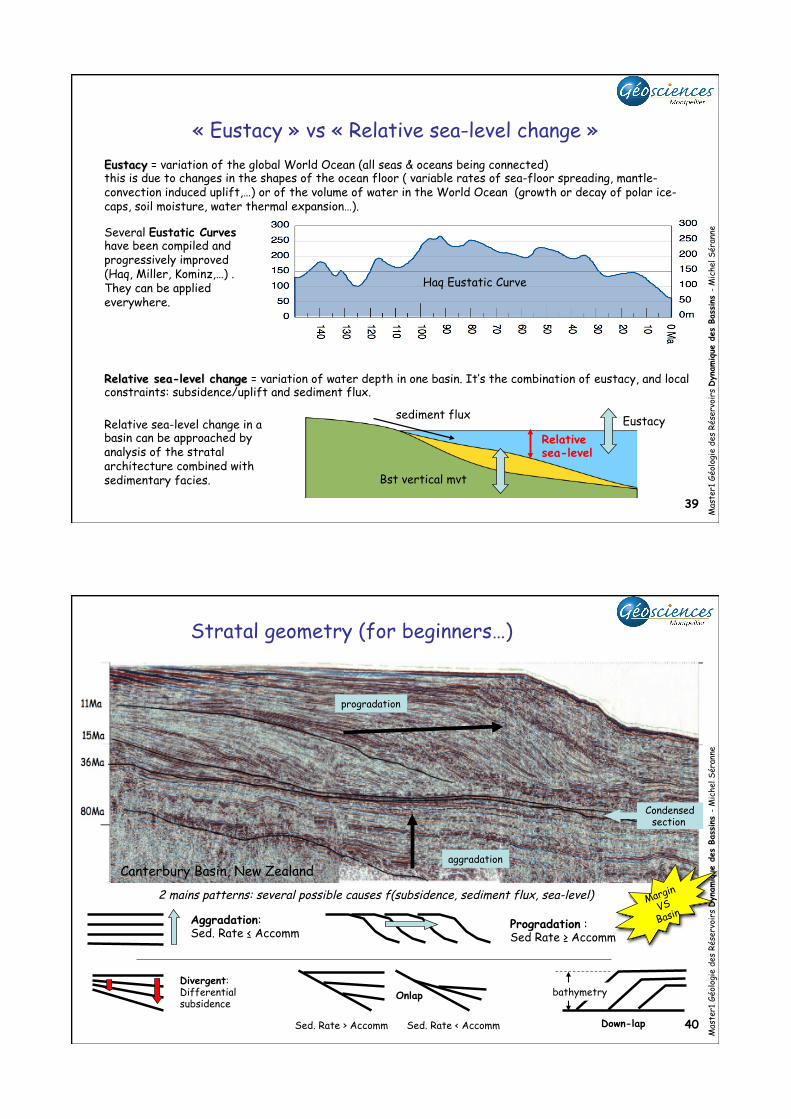
« Eustacy » vs « Relative sea-level change » Eustacy = variation of the global World Ocean (all seas & oceans being connected) this is due to changes in the shapes of the ocean floor ( variable rates of sea-floor spreading, mantle-convection induced uplift,…) or of the volume of water in the World Ocean (growth or decay of polar ice-caps, soil moisture, water thermal expansion…).
Haq Eustatic Curve
Relative sea-level change = variation of water depth in one basin. It’s the combination of eustacy, and local constraints: subsidence/uplift and sediment flux.
Several Eustatic Curves have been compiled and progressively improved (Haq, Miller, Kominz,…) . They can be applied everywhere.
Relative sea-level
Eustacy
Bst vertical mvt
sediment flux Relative sea-level change in a basin can be approached by analysis of the stratal architecture combined with sedimentary facies.
Mas
ter1
Géo
logi
e de
s Ré
serv
oirs
Dyn
amique
des
Bas
sins
- M
iche
l Sér
anne
40
Stratal geometry (for beginners…)
Canterbury Basin, New Zealand aggradation
progradation
Condensed section
Aggradation: Sed. Rate ≤ Accomm
Progradation : Sed Rate ≥ Accomm
2 mains patterns: several possible causes f(subsidence, sediment flux, sea-level)
bathymetry Divergent: Differential subsidence
Down-lap
Onlap
Sed. Rate > Accomm Sed. Rate < Accomm
Margin
VS Basin

21
Mas
ter1
Géo
logi
e de
s Ré
serv
oirs
Dyn
amique
des
Bas
sins
- M
iche
l Sér
anne
41
Fluvial & delta Slope shales
Reworked clastics
sequence boundary
Maximum Flooding Surface
Modifié d’après Bartek et al, 1991
0 +50 +100 -50 0
20
30
10
Oligocene
Miocene
Pliocene
Eustacy Sedimentation pattern of Neogene passive margins
Mas
ter1
Géo
logi
e de
s Ré
serv
oirs
Dyn
amique
des
Bas
sins
- M
iche
l Sér
anne
42 Valanginian, S. France
Orbital parameters of the Earth
variable sun energy
received
outer envelopes
temperatures sedimentation climate Stratigraphic
record
22
Mas
ter1
Géo
logi
e de
s Ré
serv
oirs
Dyn
amique
des
Bas
sins
- M
iche
l Sér
anne
43
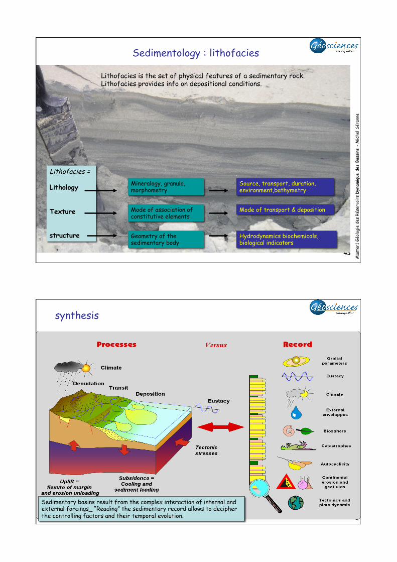
Sedimentology : lithofacies
Lithofacies is the set of physical features of a sedimentary rock. Lithofacies provides info on depositional conditions.
Lithofacies = Lithology Texture structure Geometry of the
sedimentary body
Mode of association of constitutive elements
Mineralogy, granulo, morphometry
Hydrodynamics biochemicals, biological indicators
Mode of transport & deposition
Source, transport, duration, environment,bathymetry
Mas
ter1
Géo
logi
e de
s Ré
serv
oirs
Dyn
amique
des
Bas
sins
- M
iche
l Sér
anne
44
synthesis
Sedimentary basins result from the complex interaction of internal and external forcings_ “Reading” the sedimentary record allows to decipher the controlling factors and their temporal evolution.
24
Mas
ter1
Géo
logi
e de
s Ré
serv
oirs
Dyn
amique
des
Bas
sins
- M
iche
l Sér
anne
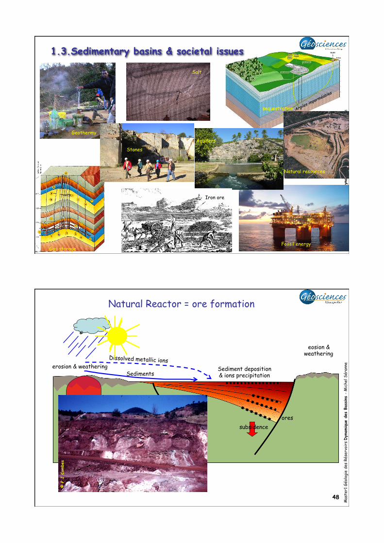
47 Fossil energy
Argiles imperméables
1.3.Sedimentary basins & societal issues
Geothermy
Iron ore
sequestration
Natural resources
Stones
Salt
Gas storage
Aquifers
Mas
ter1
Géo
logi
e de
s Ré
serv
oirs
Dyn
amique
des
Bas
sins
- M
iche
l Sér
anne
48
erosion & weathering
eosion & weathering
Dissolved metallic ions
Sediments Sediment deposition & ions precipitation
© P
.J.C
ombe
s
Natural Reactor = ore formation
ores subsidence

25
Mas
ter1
Géo
logi
e de
s Ré
serv
oirs
Dyn
amique
des
Bas
sins
- M
iche
l Sér
anne
49
Organic mater
(anoxiclake)
Biosphere (Carbon)
Biosphere
soil sol
Maturation f(temperature, pressure, time): Organic matter -> kerogene -> Oil -> gas!
burial
oil
migration
© M
. Sé
rann
e
Natural Reactor = hydrocarbons generation
Mas
ter1
Géo
logi
e de
s Ré
serv
oirs
Dyn
amique
des
Bas
sins
- M
iche
l Sér
anne
50
Consommation ressources naturelles /an / personne
Ressources minérales
eau Énergie fossile
La vaste majorité des ressources naturelles provient des bassins sédimentaires

26
Mas
ter1
Géo
logi
e de
s Ré
serv
oirs
Dyn
amique
des
Bas
sins
- M
iche
l Sér
anne
51
(estimations en 2000)
Mas
ter1
Géo
logi
e de
s Ré
serv
oirs
Dyn
amique
des
Bas
sins
- M
iche
l Sér
anne
52
Mauriaud & al, 2013 « La faim du pétrole »
Réserves & ressources mondiales de Pétrole et de Gaz
Réserves mondiales de Charbon
Ressource > 15000 Gtec ; Production = 5Gtec/an Gtec: 109 tonnes équivalent charbon
Pétrole : 2000 Gbep (dont 80% conventionnel) Gaz : 2500 Gbep (dont 49% conventionnel) Gbep: 109 barils équivalent pétrole en 2010 Réserves mondiales de pétrole & gaz= 2665 Bboe Bboe: Billion Barrel Oil Equivalent = 109 barils équivalent pétrole
conventionnel
Pétrole Gaz
non-conventionnel