12ea-242 stage 1 report 15jan2013 - veresen inc. — … draft...2. lands identified herein as low...
TRANSCRIPT

Stage 1 Background Study and Property Inspection
Grand Valley Phase 3 Wind Project
Town of Grand Valley (Former Township of East Luther)
and Amaranth Township, Dufferin County, Ontario
FIT #: FBK61WV
ORIGINAL REPORT
Prepared for: Veresen Inc.
216 Chrislea Road, Suite 502 Woodbridge, Ontario, L4L8S5
Tel: 416-479-0865 Fax: 905-264-9487
Archaeological Licence P347 (Andrew Riddle) MTCS PIF P347-145-2012 ASI File 12EA-242
16 January 2013

Stage 1 Background Study and Property Inspection
Grand Valley Phase 3 Wind Project
Town of Grand Valley (Former Township of East Luther) and Amaranth Township Dufferin County, Ontario
EXECUTIVE SUMMARY
Archaeological Services Inc (ASI) was contracted by Veresen Inc. to conduct a Stage 1 Background
Study and Property Inspection as part of the Grand Valley 3 Renewable Energy Approval (REA)
project. The project involves the construction of a transformer station, 20 possible turbine locations,
and associated electrical collector lines. The collector lines are to be located within municipal road
allowances while the turbines and transformer station are located in agricultural fields. The
preferred layout for the turbines is yet to be determined so this study focuses on the general project
area with special attention to properties that have been optioned for the Grand Valley Phase 3
project.
It should be noted that the optioned properties identified in this report may change as the Grand
Valley Phase 3 project develops. Accordingly, changes to the turbine layout and/or optioned
properties are expected. To accommodate the possibility of change to the project layout, this study
includes all lands within the general project area (bounded by Highway 89 on the north; 9th Line on
the east; Concession Road 3/Sideroad 5 on the south; and, the East- West Luther Town Line on the
east). The optioned properties at the time of survey are highlighted on the mapping and were
subject to a property inspection in order to collect a representative sample of field conditions for the
greater study area.
The background study determined that no archaeological sites have been registered within 1 km of
the study area. A review of the geography and history of the study area suggested that the study
area has potential for the identification of Aboriginal and Euro-Canadian archaeological resources.
The property inspection determined that the majority of the Grand Valley 3 study area exhibits
archaeological potential. The property inspection also found that sections of land featured low and
wet conditions, which may indicate a lack of archaeological potential.
In light of these results, ASI makes the following recommendations:
1. All lands deemed to have archaeological potential to be impacted by the proposed
development within the study area should be subject to a Stage 2 Property Assessment in
accordance with the 2011 Standards and Guidelines for Consultant Archaeologists;

2. Lands identified herein as low and wet should be examined during the Stage 2 assessment
to confirm the lack of archaeological potential. If, upon further inspection, such lands are
deemed to have archaeological potential, Stage 2 property assessment should be
conducted on these lands per Recommendation 1;
3. Should adjustments to the Project location result in the inclusion of lands outside of the
current study area, further Stage 1 assessment must be conducted to determine the
archaeological potential of said lands.

Stage 1 Background Study and Property Inspection Grand Valley Phase 3, REA Town of Grand Valley and Amaranth Township, Ontario Page iii
ARCHAEOLOGICAL SERVICES INC. ENVIRONMENTAL ASSESSMENT DIVISION
PROJECT PERSONNEL
Senior Project Manager: Robert Pihl, MA, CAHP [MTCS licence P057] Partner and Senior Archaeologist Manager, Environmental Assessment Division
Project Director (licensee): Andrew Riddle, PhD [MTCS license P347] Senior Archaeologist, Environmental Assessment Division
Project Archaeologist: Heidy Schopf, MES Research Archaeologist
Project Coordinator: Sarah Jagelewski, Hon. BA [MTCS license R405] Staff Archaeologist
Field Director: Peter Carruthers, MA, CAHP [MTCS license P163] Senior Associate
Report Writer and Graphics: Heidy Schopf
Graphics: Jonas Fernandez, MSc GIS Technician Blake Williams, MLitt [MTCS license P383] GIS Technician
Report Reviewer: Robert Pihl

Stage 1 Background Study and Property Inspection Grand Valley Phase 3 Wind Project Town of Grand Valley and Amaranth Township, Dufferin County, Ontario Page iv
TABLE OF CONTENTS EXECUTIVE SUMMARY ................................................................................................................................... i PROJECT PERSONNEL................................................................................................................................... iii 1.0 PROJECT CONTEXT ........................................................................................................................... 1
1.1 Development Context .................................................................................................................. 1 1.2 Historical Context ....................................................................................................................... 2
1.2.1 Aboriginal Land Use ............................................................................................................. 3 1.2.2 Township Survey and Settlement .......................................................................................... 4 1.2.3 Land-Use History: Surveyors Notes ....................................................................................... 5 1.2.4 Historic Map Review ............................................................................................................. 6 1.2.5 Summary of Historical Context .............................................................................................. 7
1.3 Archaeological Context ............................................................................................................... 7 1.3.1 Current Land Use and Field Conditions .................................................................................. 7 1.3.2 Geography ........................................................................................................................... 8 1.3.3 Previous Archaeological Research ....................................................................................... 10 1.3.4 Summary of Archaeological Context .....................................................................................12
2.0 FIELD METHODS .............................................................................................................................12 3.0 ANALYSIS AND CONCLUSIONS ........................................................................................................12
3.1 Analysis of Archaeological Potential ........................................................................................... 13 3.2 Archaeological Potential Model .................................................................................................. 13 3.3 Analysis of Property Inspection Results ..................................................................................... 14 3.4 Conclusions .............................................................................................................................. 14
4.0 RECOMMENDATIONS ..................................................................................................................... 14 5.0 ADVICE ON COMPLIANCE WITH LEGISLATION.................................................................................... 15 6.0 BIBLIOGRAPHY .............................................................................................................................. 16 7.0 MAPS ............................................................................................................................................19 8.0 IMAGES ........................................................................................................................................ 28
LIST OF TABLES Table 1: Lots and Concessions for Optioned Properties in the Grand Valley 3 study area ................................. 2 Table 2: Soils in the Grand Valley 3 study area .............................................................................................. 9
LIST OF FIGURES Figure 1: Location of the study area ............................................................................................................. 20 Figure 2: The study area overlaid on the 1831 survey map of Luther Township............................................... 21 Figure 3: The study area overlaid on the 1856 survey map of Luther Township .............................................. 21 Figure 4: The study area overlaid on the 1823 survey map of Amaranth Township ......................................... 21 Figure 5: The study area overlaid on the 1877 map of Luther Township ......................................................... 22 Figure 6: The study area overlaid on the 19- Map of Dufferin County ............................................................. 23 Figure 7: The study area overlaid on the 1920 map of Dufferin County .......................................................... 23 Figure 8: The study area overlaid on the 1929 map of Dufferin County .......................................................... 23 Figure 9: Surficial Geology in the Grand Valley Phase 3 study area ............................................................... 24 Figure 10: Soil drainage in the Grand Valley Phase 3 study area ................................................................... 25 Figure 11: Soils in the Grand Valley Phase 3 study area ................................................................................ 26 Figure 12: Archaeological Potential in the Grand Valley Phase 3 study area .................................................. 27

Stage 1 Background Study and Property Inspection Grand Valley Phase 3 Wind Project Town of Grand Valley and Amaranth Township, Dufferin County, Ontario Page v
LIST OF PLATES Plate 1: East-northeast view along Concession Road 12 & 13. All potential in field. ........................................ 28 Plate 2: North view of Turbine 2 property. All potential. ............................................................................... 28 Plate 3: West-northwest view of Turbine 1 property. Field has potential. ....................................................... 28 Plate 4: South view of property for Turbines 3 and 4. Field has potential. ..................................................... 28 Plate 5: South-southeast view of Turbine 5 property. Field has potential....................................................... 28 Plate 6: South-southeast view of Turbine 5 property. All potential. ............................................................... 28 Plate 7: West view of Turbine 6 property. Fields in distance and to right have potential. ................................ 29 Plate 8: Northeast view of Turbine 7 property. Field has potential. ............................................................... 29 Plate 9: South-southeast view of Turbine 8 property. Field has potential. ..................................................... 29 Plate 10: Southwest view of Turbine 19. Field has potential. ......................................................................... 29 Plate 11: East-northeast view of Turbine 9 property. Field has potential. Note low/wet conditions in
foreground. ................................................................................................................................ 29 Plate 12: Northeast view of Turbine 10 property. Field has potential. ............................................................ 29 Plate 13: Northwest view of Turbines 11 and 12 properties. All potential. ....................................................... 30 Plate 14: South-southeast view of Turbine 13 property. All potential. ............................................................ 30 Plate 15: Southwest view of Turbine 14 property. All potential. ..................................................................... 30 Plate 16: Southwest view of Turbine 15 property. All potential. ..................................................................... 30 Plate 17: North-northeast view of Turbines 17/18 property. Field has potential. Note low/wet conditions
in foreground. ............................................................................................................................. 30 Plate 18: East view of Turbine 16 property – all potential. ............................................................................. 30
LIST OF APPENDICES
APPENDIX A: Details of historic property owners and historic features in the study area .................................31

Stage 1 Background Study and Property Inspection Grand Valley Phase 3 Town of Grand Valley and Amaranth Township, Dufferin County Ontario Page 1
1.0 PROJECT CONTEXT The objectives of this report are:
To provide information about the geography, history, previous archaeological fieldwork and current land condition of the study area;
To evaluate in detail the archaeological potential of the study area which can be used, if
necessary, to support recommendations for Stage 2 Property Assessment for all or parts of the property; and
To recommend appropriate strategies for Stage 2 Property Assessment, if necessary.
This report describes the Stage 1 assessment that was conducted for this project and is organized as follows: Section 1.0 describes the project context and summarizes the background study that was conducted to provide the archaeological and historical context for the project study area; Section 2.0 describes the field methods used during the assessment and summarizes the results of the property inspection; Section 3.0 provides an analysis of the assessment results and evaluates the archaeological potential of the study area; Section 4.0 provides recommendations for the next assessment steps; and the remaining sections contain other report information that is required by the Standards and Guidelines for Consultant Archaeologists (MTC 2011), which is administered by the Ministry of Tourism, Culture and Sport (MTCS), e.g., advice on compliance with legislation, works cited, mapping and photo-documentation. 1.1 Development Context Archaeological Services Inc (ASI) was contracted by Veresen Inc. to conduct a Stage 1 Background Study and Property Inspection as part of the Grand Valley 3 Renewable Energy Approval (REA) project. The project involves the construction of a transformer station, 20 possible turbine locations, and associated electrical collector lines. The collector lines are to be located within municipal road allowances while the turbines and transformer station are located in agricultural fields. The preferred layout for the turbines is yet to be determined so this study focuses on the general project area with special attention to properties that have been optioned for the Grand Valley Phase 3 project (Figure 1). It should be noted that the optioned properties identified in this report may change as the Grand Valley Phase 3 project develops. Accordingly, changes to the turbine layout and/or optioned properties are expected. To accommodate the possibility of change to the project layout, this study includes all lands within the general project area (bounded by Highway 89 on the north; 9th Line on the east; Concession Road 3/Sideroad 5 on the south; and, the East- West Luther Town Line on the east). The optioned properties at the time of survey are highlighted on the mapping and were subject to a property inspection in order to collect a representative sample of field conditions for the greater study area.
The archaeological assessment is conducted under Ontario Regulation 359/09, the Renewable Energy Approvals (REA) under Part V.0.1 of the Environmental Protection Act (Ministry of the Environment [MOE] 2009). Under Section 20 (1) and Section 21 of the REA process, the Project

Stage 1 Background Study and Property Inspection Grand Valley Phase 3 Town of Grand Valley and Amaranth Township, Dufferin County Ontario Page 2
must determine if there will be a potential impact to an archaeological resource and, under Section 22, an archaeological assessment must be undertaken if potential impact is determined. All activities carried out during this assessment were completed in accordance with the terms of the Ontario Heritage Act (2005) and the Standards and Guidelines for Consultant Archaeologists (S & G). Permission to carry out all activities necessary for the completion of the assessment was granted by Veresen Inc. on December 7, 2012. 1.2 Historical Context
This section provides a brief summary of historic research for the study area. A review of available primary and secondary source material was undertaken to produce a contextual overview, including a general description of settlement and historic land use. Historically, the study area is located the former Townships of East Luther and Amaranth, Dufferin County in the following lots and concessions: Township of East Luther
Concession 3, Lots 19-32 Concession 4, Lots 19-32 Concession 5, Lots 19-32 Concession 6, Lots 19-32 Concession 7, Lots 19-32 Concession 8, Lots 19-32 Concession 9, Lots 19-32 Concession 10, Lots 19-32 Concession 11, Lots 19-32 Concession 12, Lots 19-32 Concession 13, Lots 19-32 Concession 14, Lots 19-32
Township of Amaranth
Concession 9, Lots 6-32 Concession 10, Lots 6-32
The lots and concessions for the optioned properties are summarized in Table 1.
Table 1: Lots and Concessions for Optioned Properties in the Grand Valley 3 study area Project Feature Township Concession Lot(s) Turbine 1 East Luther 13 20, 21 Turbine 2 East Luther 13 20 Turbines 3 and 4 East Luther 12 23 Turbine 5 East Luther 9 29 Turbine 6 East Luther 9 32 Turbine 7 Amaranth 10 20 Turbine 8 Amaranth 10 19 Turbine 9 East Luther 6 28

Stage 1 Background Study and Property Inspection Grand Valley Phase 3 Town of Grand Valley and Amaranth Township, Dufferin County Ontario Page 3
Turbine 10 East Luther 5 28 Turbines 11 and 12 East Luther 5 26 Turbine 13 East Luther 4 25 Turbine 14 East Luther 4 24 Turbine 15 East Luther 3 24 Turbine 16 East Luther 4 22 Turbines 17 and 18 East Luther 3 23 Turbine 19 East Luther 8 30
1.2.1 Aboriginal Land Use The lands between Lake Erie and Lake Huron were highly contested during the contact period of southwestern Ontario (Johnston 2004:9). An early Jesuit map entitled Nouvelle France depicts this area as a border zone between peoples of difference cultures and languages. The introduction of European trade goods, weapons, missionaries, and diseases served to exacerbate previous tensions between Aboriginal groups (Johnston 2004:9). One result of this was that the between 1648 and 1650 Iroquois from New York State conducted a series of attacks on Neutral and Huron-Wendat groups in southern and southwestern Ontario. These attacks weakened the Huron-Wendat and Neutral and caused them to disperse to other locations in Ontario (Goodspeed and Goodspeed 1889:16). The Iroquoian dominance of the region did not go unchallenged and by 1653, the Jesuits reported that several nations, including the Anishnaabeg (Chippewa or Ojiway, Mississauga, Ottawa, Pottawatomi) and the remains of the Neutral had united against the Iroquois (Warren 1885:97). As a result there were many battles in the area between Lake Erie and Georgian Bay. Burial mounds in this region reflect the territorial disputes between the Iroquois and other Aboriginal groups during this period. Peace was achieved between the Iroquois and the Anishnaabeg Nations in August of 1701 when representatives of more than twenty Anishnaabeg Nations assembled in Montreal to participate in peace negotiations (Johnston 2004:10). During these negotiations captives were exchanged and the Iroquois and Anishnaabeg agreed to live together in peace. Peace between these nations was confirmed again at council held at Lake Superior when the Iroquois delivered a wampum belt to the Anishnaabeg Nations. By 1718 several well-established villages were documented in the vicinity of Detroit. In addition to the Huron-Wendat, Potawatami, and Ottawas villages, a known village of Mississauga and Chippewa was located on the shore of Lake Huron, north of the Thames River (Johnston 2004:12). Despite the disruptions in settlements due to disease and warfare, the area between Lake Erie and Lake Huron had been restored to peace by the turn of the 18th century (Warren 1885:79). The Anishnaabeg were early and consistent allies of the French and were one of the first Aboriginal groups to receive firearms. With the aid of guns they were able to drive the Sioux into the Great Plains and the Sauk, Mesquaki, and Kickapoo groups southward towards northern Wisconsin (Waldman 2006:67). In the mid-1700s the Anishnaabeg fought the British in the French and Indian wars and in Pontiac’s Rebellion. Later, during the American Revolution, the Anishnaabeg became allies of the British against the American rebels. They also fought American’s again in the Indian wars for the Old Northwest and in the War of 1812 (Waldman 2006:67).

Stage 1 Background Study and Property Inspection Grand Valley Phase 3 Town of Grand Valley and Amaranth Township, Dufferin County Ontario Page 4
It should be noted that few archaeological resources have been documented in the Grand Valley area. This is attributed to the fact that the lands in the Grand Valley area were predominantly swamp land prior to the 1950s at which point extensive drainage projects were completed. Accordingly, the vast morass which characterizes most of the study area has been artificially drained to create the current farmland. Like a giant sponge, this porous upland is one of the prime groundwater recharge areas of southern Ontario, forming the headwaters of the Grand River, amongst others. At the same time, it no doubt presented significant land-use challenges to both pre-contact Aboriginal peoples and post-contact Euro-Canadian pioneers. The challenge of settling in this landscape is echoed by the fact that pre-contact site density falls off significantly upstream of Cambridge in the Grand Valley. It should be noted, however, that the study area would have provided valuable hunting grounds for pre-contact peoples in the Grand Valley area. 1.2.2 Township Survey and Settlement The study area is located in the Townships of East Luther and Amaranth, Dufferin County. Dufferin County is situated on the highest plateau of land in the province and forms the watershed for most of the productive agricultural land in southwestern Ontario. The headwaters of several key rivers area located in the county including the Grand, Saugeen, Nottawasaga, Credit and Humber Rivers. Dufferin County is sometimes called the “roof on Ontario” because of its altitude, although it should be noted that no one area of the county is higher or lower than any other and drainage takes place in all directions (Mika and Mika 1977:582). Dufferin County, which is comprised of the townships of Amaranth, East Garafraxa, East Luther, Melancthon, Mono, and Mulmur, did not exist as a county prior to 1879. Before this date, Melancthon and the Village of Shelburne were located in Grey County; Mono and Mulmur Townships formed part of Simcoe County; and Amaranth, and parts of Garafraxa and Luther were included in Wellington County (Mika and Mika 1977:582). Township of East Luther The survey of Luther Township was first started in 1837 by Louis Burwell, P.L.S. and was completed between 1854 and 1855 by William McPhillips. East Luther was initially part of the Township of Luther, which was established in 1821 and was named after Martin Luther, the 16th century leader of the German Reformation (Mika and Mika 1977:619). The first settlers in East Luther include Richard Joice, Samuel Stuckey and Richard Ponsford. They settled in the southeast corner of the township, near the present location of the Town of Grand Valley. The settlement of Grand Valley quickly developed into the commercial centre of the township and was aided in this development by the arrival of the railway in 1870. Settlement in the Luther Marsh areas occurred half a century later than settlement in the Grand River area due to the swampy nature of the land (Ministry of Natural Resources 2010). The Luther Marsh area was considered to be “unbroken wilderness” until 1853, when the first large group of settlers arrived from the British Isles. The Township of Luther was included in Wellington County until 1860 and was later divided in to East and West Luther Townships. The Township of East Luther became part of the new

Stage 1 Background Study and Property Inspection Grand Valley Phase 3 Town of Grand Valley and Amaranth Township, Dufferin County Ontario Page 5
Dufferin County in 1883. Early twentieth century settlements in East Luther Township include Colbeck, Wesley, Monticello, Leggatt, Tarbert, and Peepabun. Township of Amaranth The Township of Amaranth was surveyed between 1822 and 1823 by Hugh Black, Deputy Surveyor. The Township is said to be named after the Amaranth plant, which grows in abundance in the area. The first settler in the township is said to have been Abraham Hugheson, who settled here in 1832. Other settlers joined him a few years later, including Charles Gillespie, Water Cooney, Samuel Munroe, John Stopford, Robert Keyes, John Rennick, Daniel Severs, and Neil McGill. The population of Amaranth Township had reached 1,200 by the year 1861 (Mika and Mika 1977:57). Amaranth was first part of the Simcoe District Territory but was later attached to Wellington County in 1841. In 1879, the new County of Dufferin was formed and Amaranth Township was included in the new county. The Grand River flows through the township, which is mostly comprised of arable land. 1.2.3 Land-Use History: Surveyors Notes The original field journal kept during the survey of Luther Townships was reviewed in order to identify any potential First Nation or early Euro-Canadian features of interest in the study area. A micro-fiche copy of the journal penned by Lewis Burwell in 1831 was reviewed at the Ontario Archives on November 13, 2012. The document was written between July 4 and October 15 and includes descriptions of the landscape, topography, and other features of interest encountered during the survey. Many references were made to the swampy and harsh conditions of Luther Township. No First Nation settlements were noted in the survey journal, but two Aboriginal men were included in Burwell’s crew. These men were named Ebenezer Bule and Henrick French, and they are first mentioned by Burwell on August 3, 1831 They were hired to replace two men who had fallen ill during the course of the survey. Ebenezer Bule is mentioned several times in subsequent journal entries and is noted for having “frequently hunted along the upper branches of the Grand River.” Bule is credited with providing game for the survey party on several occasions, including an instance when a bear raided their supplies and took the majority of their food (Burwell 1831). While no First Nation settlements are mentioned in the journal is should be noted that the study area seems to have served as a hunting ground for Aboriginal peoples in the area. This reflects the lack of general lack of archaeological sites in the area since the swampy conditions would have served as a deterrent for permanent settlements but would have served as hunting grounds for nearby groups. The surveyor’s journal for Amaranth Township was also reviewed to determine the presence of any First Nation or early Euro-Canadian features of interest. The journal was written in 1822 by Hugh Black, who was the surveyor for the township. The notes for Concessions 9 and 10 were reviewed but there was no mention of any Aboriginal or Euro-Canadian settlements/features. Black’s notes mainly focus on tree species, the general locations of watercourses, and any notable landscape features. He occasionally notes the presence of beaver dams and ponds. In terms of the optioned properties, Black noted that the land in Concession 10, Lots 19 and 20 was swampy with

Stage 1 Background Study and Property Inspection Grand Valley Phase 3 Town of Grand Valley and Amaranth Township, Dufferin County Ontario Page 6
various tree species present (Black 1822:41). He also noted that a brook ran in a westerly direction through Lot 20, and that Lot 19 was reserved as clergy land (Black 1922: 41 and 45). 1.2.4 Historic Map Review The original surveyor’s maps for Luther and Amaranth Townships were reviewed to determine the presence of any First Nations or Euro-Canadian features in the Grand Valley 3 study area (Figures 2, 3, and 4). The 1831 and 1856 surveyor’s maps were reviewed for Luther Township, and the 1823 surveyor’s map was reviewed for Amaranth Township. The surveyor’s maps for Luther Township demonstrate that the majority of lands within the study area were designated as crown land (highlighted in pink) or clergy land (highlighted in grey). Several property owners are listed on the 1831 map, but no property owners or features are shown on the 1856 map. Details of the 1831 property owners are provided in Appendix A. The 1823 surveyor’s map for Amaranth Township does not depict any historic features or specific property owners. However, the map does distinguish between crown and clergy lands. In terms of the current study area, Lot 20, Concession 10 (the location for Turbine 7) is shown to be clergy land. In addition to the surveyor’s maps, the 1877 Map of Wellington County was reviewed to determine the potential for the presence of historic archaeological resources within the study area during the nineteenth century (Figure 5). It should be noted, however, that not all features of interest were mapped systematically in the Ontario series of historical atlases, given that they were financed by subscription, and subscribers were given preference with regard to the level of detail provided on the maps. Moreover, not every feature of interest would have been within the scope of the atlases. Historically, the study area is located in the former Townships of East Luther and Amaranth, Dufferin County. Details of property owners and historic features present in the study area are listed in Appendix A. It should be noted that nineteenth century historic mapping for Amaranth Township is unavailable. Therefore, no property owners are listed for the portion of the study area located in Amaranth Township. Historic mapping was reviewed as part of historical research, and it was determined that the study area was a rural, agricultural landscape from the early township settlement period in the early nineteenth century. The study area features numerous historic roads including Concession Road 12 & 13, Sideroad 24 & 25, Concession Road 8 & 9, Concession Road 27 & 28, Concession Road 4 & 5, Sideroad 24 & 25, Concession Road 2 & 3 and Sideroad 2 & 3. Numerous property owners are also listed within the study area. Historic features depicted in the study area include the Colbeck Post Office, Talbert Post Office, Peepabun Post Office, Luther Post Office, three schools, and a mill. All historic features are located adjacent to historic roads. Twentieth century mapping was also reviewed to determine any development within the study area at the beginning of the 1900s (Figures 6, 7, and 8). Several settlement centres are noted on the maps including Wesley, Leggatt, Tarbert, and Peepabun. Several prominent buildings are shown in Figure 8, although a description of these structures is not provided. Figure 3 also demonstrates that additional roads were added to the area in the early twentieth century.

Stage 1 Background Study and Property Inspection Grand Valley Phase 3 Town of Grand Valley and Amaranth Township, Dufferin County Ontario Page 7
For the Euro-Canadian period, the majority of early nineteenth century farmsteads (i.e., those which are arguably the most potentially significant resources and whose locations are rarely recorded on nineteenth century maps) are likely to be captured by the basic proximity to the water model outlined in Section 1.2.2 of this report. since these occupations were subject to similar environmental constraints. Section 1.3.1 of the S & G stipulates that areas of early Euro-Canadian settlement (pioneer homesteads, isolated cabins, farmstead complexes), early wharf or dock complexes, pioneer churches and early cemeteries, are considered to have archaeological potential. Early historical transportation routes (trails, passes, roads, railways, portage routes), properties listed on a municipal register or designated under the Ontario Heritage Act or a federal, provincial, or municipal historic landmark or site are also considered to have archaeological potential. 1.2.5 Summary of Historical Context The background research and historic mapping demonstrates the study area retains archaeological potential due to the presence of historic features within and/or in close proximity to the study area. The study area also includes several historically surveyed roads, which are indicators of archaeological potential. Further, the background research demonstrated that the study area retains potential for the recovery of pre-contact and contact period archaeological resources. While the archaeological record for the Grand Valley area is sparse, the original surveyor’s journal suggests that Luther Township could have served as an Aboriginal hunting ground. 1.3 Archaeological Context This section provides background research pertaining to previous archaeological fieldwork conducted within and in the vicinity of the Grand Valley 3 study area, its environmental characteristics (including drainage, soils or surficial geology and topography, etc.), and current land use and field conditions. Three sources of information were consulted to provide information about previous archaeological research in the study area; the site record forms for registered sites housed at the MTCS; published and unpublished documentary sources; and the files of ASI. 1.3.1 Current Land Use and Field Conditions The Stage 1 property inspection was conducted by Peter Carruthers (P163) ASI, on November 29, 2012. The Grand Valley Phase 3 study area includes 17 turbine locations, a transformer station and associated electrical collector lines. The turbine locations and transformer site are located in actively cultivated agricultural fields, while the collector lines are located within existing road rights-of-way (ROW). The property inspection focused on the turbine locations and transformer site. The property inspection found that the majority of the optioned properties appeared relatively undisturbed and retained archaeological potential. It was also found that numerous parcels of land featured permanently low and wet conditions. These low and wet areas are characteristic of

Stage 1 Background Study and Property Inspection Grand Valley Phase 3 Town of Grand Valley and Amaranth Township, Dufferin County Ontario Page 8
Dundalk Till Plains region and reflected the varied soil types present in the study area. The property inspection also noted that several fields were former wetlands that were drained to accommodate agricultural land uses. These fields were not considered to have archaeological potential since the drainage of these lands was relatively recent. As discussed in Section 1.1 of this report, the property inspection focused on the optioned properties in order to get a representative sample of photos for the general study area. It is recognized that further archaeological assessment is required to account for any changes to the Grand Valley Stage 3 project layout. 1.3.2 Geography In addition to the known archaeological sites, the state of the natural environment is an important predictor of archaeological potential. Accordingly, a description of the study area physiography and soils is provided below. Section 1.3.1 of the S & G stipulates that primary water sources (lakes, rivers, streams, creeks, etc.), secondary water sources (intermittent streams and creeks, springs, marshes, swamps, etc.), ancient water sources (glacial lake shorelines indicated by the presence of raised sand or gravel beach ridges, relic river or stream channels indicated by clear dip or swale in the topography, shorelines of drained lakes or marshes, cobble beaches, etc.), as well as accessible or inaccessible shorelines (high bluffs, swamp or marsh fields by the edge of a lake, sandbars stretching into marsh, etc.) are characteristics that indicate archaeological potential. Water has been identified as the major determinant of site selection and the presence of potable water is the single most important resource necessary for any extended human occupation or settlement. Since water sources have remained relatively stable in Ontario after the Pleistocene era, proximity to water can be regarded as a useful index for the evaluation of archaeological site potential. Indeed, distance from water has been one of the most commonly used variables for predictive modeling of site location. Section 1.3.1 of the S & G also lists other geographic characteristics that can indicate archaeological potential including: elevated topography (eskers, drumlins, large knolls, plateaux), pockets of well-drained sandy soil, especially near areas of heavy soil or rocky ground, distinctive land formations that might have been special or spiritual places, such as waterfalls, rock outcrops, caverns, mounds, and promontories and their bases. Physical indicators of use may be present, such as burials, structures, offerings, rock paintings or carvings. Resource areas, including; food or medicinal plants (migratory routes, spawning areas) are also considered characteristics that indicate archaeological potential. The study area falls within the Dundalk Till Plain physiographic region of southern Ontario. The Dundalk Till Plain is considered the “roof” of peninsular Ontario and comprises and area of approximately 2,370 square kilometres and low drumlinoidal swells appear with their long axes oriented southeastward (Chapman and Putnam 1984). With an elevation of 425 to 530 m, this region forms the watershed, which serves as the headwaters of the Saugeen, Maitland, and Grand River, as well as those of the Nottawasaga. The valleys are frequently swampy, containing small steams or no streams at all.
Stage 1 Background Study and Property Inspection Grand Valley Phase 3 Town of Grand Valley and Amaranth Township, Dufferin County Ontario Page 9
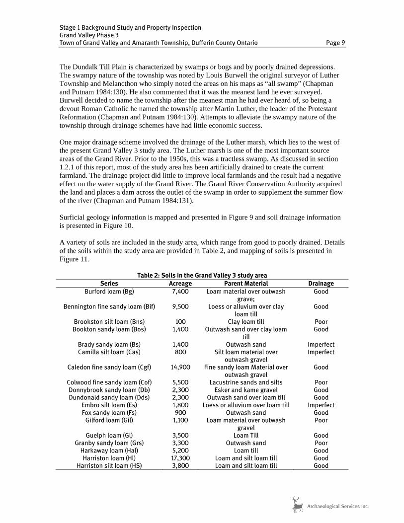
The Dundalk Till Plain is characterized by swamps or bogs and by poorly drained depressions. The swampy nature of the township was noted by Louis Burwell the original surveyor of Luther Township and Melancthon who simply noted the areas on his maps as “all swamp” (Chapman and Putnam 1984:130). He also commented that it was the meanest land he ever surveyed. Burwell decided to name the township after the meanest man he had ever heard of, so being a devout Roman Catholic he named the township after Martin Luther, the leader of the Protestant Reformation (Chapman and Putnam 1984:130). Attempts to alleviate the swampy nature of the township through drainage schemes have had little economic success. One major drainage scheme involved the drainage of the Luther marsh, which lies to the west of the present Grand Valley 3 study area. The Luther marsh is one of the most important source areas of the Grand River. Prior to the 1950s, this was a tractless swamp. As discussed in section 1.2.1 of this report, most of the study area has been artificially drained to create the current farmland. The drainage project did little to improve local farmlands and the result had a negative effect on the water supply of the Grand River. The Grand River Conservation Authority acquired the land and places a dam across the outlet of the swamp in order to supplement the summer flow of the river (Chapman and Putnam 1984:131). Surficial geology information is mapped and presented in Figure 9 and soil drainage information is presented in Figure 10. A variety of soils are included in the study area, which range from good to poorly drained. Details of the soils within the study area are provided in Table 2, and mapping of soils is presented in Figure 11.
Table 2: Soils in the Grand Valley 3 study area Series Acreage Parent Material Drainage
Burford loam (Bg) 7,400 Loam material over outwash grave;
Good
Bennington fine sandy loam (Bif) 9,500 Loess or alluvium over clay loam till
Good
Brookston silt loam (Bns) 100 Clay loam till Poor Bookton sandy loam (Bos) 1,400 Outwash sand over clay loam
till Good
Brady sandy loam (Bs) 1,400 Outwash sand Imperfect Camilla silt loam (Cas) 800 Silt loam material over
outwash gravel Imperfect
Caledon fine sandy loam (Cgf) 14,900 Fine sandy loam Material over outwash gravel
Good
Colwood fine sandy loam (Cof) 5,500 Lacustrine sands and silts Poor Donnybrook sandy loam (Db) 2,300 Esker and kame gravel Good Dundonald sandy loam (Dds) 2,300 Outwash sand over loam till Good
Embro silt loam (Es) 1,800 Loess or alluvium over loam till Imperfect Fox sandy loam (Fs) 900 Outwash sand Good
Gilford loam (Gil) 1,100 Loam material over outwash gravel
Poor
Guelph loam (Gl) 3,500 Loam Till Good Granby sandy loam (Grs) 3,300 Outwash sand Poor
Harkaway loam (Hal) 5,200 Loam till Good Harriston loam (Hl) 17,300 Loam and silt loam till Good
Harriston silt loam (HS) 3,800 Loam and silt loam till Good

Stage 1 Background Study and Property Inspection Grand Valley Phase 3 Town of Grand Valley and Amaranth Township, Dufferin County Ontario Page 10
Series Acreage Parent Material Drainage
Huron loam (Hul) 13,800 Clay loam till Good Listowel loam (Lil) 12,900 Loam and silt loam till Imperfect
Listowel silt loam (Lis) 1,700 Loam and silt loam till Imperfect London loam (Ll) 2,100 Loam Till Imperfect
Muck (M) 31,000 - - Maplewood fine sandy loam (Mwf) 1,400 Loess or alluvium over clay
loam till Poor
Peat (P) 2,500 - - Parkhill loam (Pal) 18,500 Loam Till Poor
Perth loam (Pl) 3,800 Clay loam till Imperfect Tavistock fine sandy loam (Taf) 1,200 Loess or alluvium over clay
loam till Imperfect
Tavistock silt loam (Tas) 4,300 Toledo clay loam (Tc) 1,000 Lacustrine silty clay loam Poor
Note: Soil information from Hoffman, Matthews, and Wicklund (1954)
In terms of water sources, the study area falls within the Grand River watershed (Grand River Conservation Authority 2012a). The Grand River is the major water source in the area, which runs north to south through the study area. The Grand River serves as a major resource to the area and has been used as a transportation axis and resource by Aboriginal cultures for more than 10,000 years (Grand Valley Conservation Authority 2012b). The Grand River is even recognized as a Canadian Heritage River due to its major influence on the Aboriginal land-use and subsequent Euro-Canadian settlement of southwestern Ontario. The Grand River flows 300 km through southwestern Ontario from the highlands of Dufferin County to Port Maitland on Lake Erie. It should be noted that the Grand Valley 3 study area falls within the headlands of the Grand Valley watershed. Accordingly, the study area features numerous wetlands, which serve to as a groundwater recharge system for the entire Grand River watershed (Ministry of Natural Resources 2010). 1.3.3 Previous Archaeological Research In Ontario, information concerning archaeological sites is stored in the Ontario Archaeological Sites Database (OASD) maintained by the MTCS. This database contains archaeological sites registered within the Borden system. Under the Borden system, Canada has been divided into grid blocks based on latitude and longitude. A Borden block is approximately 13 km east to west, and approximately 18.5 km north to south. Each Borden block is referenced by a four-letter designator, and sites within a block are numbered sequentially as they are found. The study area under review is located in Borden blocks AjGw. According to the OASD (MTCS 2012), no identified archaeological sites are located within 1 km of the study area. A number of archaeological assessments have been carried out in the vicinity of the study area as part of the previous phases of the Grand Valley wind project. Reports of this work are summarized below. Fisher Archaeological Consulting prepared Stage 1 archaeological assessment for the Grand Valley Wind Turbine Project. The study area included lands in Concession 7, Lots 29-32 and

Stage 1 Background Study and Property Inspection Grand Valley Phase 3 Town of Grand Valley and Amaranth Township, Dufferin County Ontario Page 11
Concession 8, Lot 30 in for Township of East Luther. The report included background research and wind shield survey for selected turbine locations. Stage 2 archaeological assessment was recommended for several sections of the study area and no further work was recommended for areas identified as having low archaeological potential (Fisher Archaeological Consulting n.d.). Fisher Archaeological Consulting conducted a Stage 1 archaeological assessment for Turbine locations located in Concession 9 (Lots 26 and 27), Concession 12 (Lots 24, 29, and 30), Concession 13 (Lot 32), and Concession 14 (Lots 29 and 31). The report included background research and wind shield survey for selected turbine locations. Stage 2 archaeological assessment was recommended for several sections of the study area and no further work was recommended for areas identified as having low archaeological potential (Fisher Archaeological Consulting 2007; C.I.F. # P042-127-2007). D.R. Poulton & Associates Inc. conducted a Stage 2 archaeological assessment of the proposed Grand Valley Wind Farm Project in 2010. The 2010 assessment included the locations of Turbines 1, 2, 5, 6, and 8. These turbine locations were located in Concessions 6 and 7 (Lot 32), Concession 8 (Lots 29 and 30), and Concession 14 (Lots 29 and 31) in the former Township of East Luther, Dufferin County. Stage 2 assessment activities included both pedestrian and test pit survey. No archaeological resources were recovered during the assessment and no further work was recommended for these turbine locations (D.R. Poulton & Associates 2011a; PIF# P316-100-2010). D.R. Poulton & Associates Inc. conducted a Stage 1 archaeological assessment of Turbines 3, 23, and 24 of the Grand Valley Wind Farm Project in 2011. Turbine 3 is located in Concession 7 (Lot 31), and Turbines 23 and 24 are located in Concession 14 (Lot 29) in the former Township of East Luther. The report found that all three Turbine locations did no retain archaeological potential due to low/wet conditions and previous disturbance. No further work was recommended for these turbine locations (D.R. Poulton & Associates 2011b; PIF# P316-138-2011). D.R. Poulton & Associates Inc. conducted a Stage 2 archaeological assessment of Transformers 1 and 2 of the Grand Valley Wind Farm Project in 2011. Transformers 1 and 2 are located in part of Concession 7, Lot 32 in the former Township of East Luther. Test pit survey was carried out for both transformer locations. No archaeological resources were recovered during the assessment and no further work was recommended (D.R. Poulton & Associates 2011c; PIF# P316-106-2011). D.R. Poulton & Associates Inc. conducted a Stage 2 archaeological assessment of Turbines 13 and 15 of the Grand Valley Wind Farm Project in 2011. Turbines 13 and 15 are located in part of Concession 12, Lot 29 in the former Township of East Luther. Assessment activities consisted of both pedestrian and test pit survey. No archaeological resources were recovered during the assessment and no further work was recommended (D.R. Poulton & Associates 2011d; PIF# P316-136-2011). D.R. Poulton & Associates Inc. conducted a Stage 2 archaeological assessment of Turbine 21 of the Grand Valley Wind Farm Project in 2011. Turbine 21 is located in part of Concession 14, Lot 31 in the former Township of East Luther. Assessment activities consisted of both pedestrian survey at 5 m intervals. No archaeological resources were recovered during the assessment and no further work was recommended (D.R. Poulton & Associates 2011e; PIF# P316-105-2011).

Stage 1 Background Study and Property Inspection Grand Valley Phase 3 Town of Grand Valley and Amaranth Township, Dufferin County Ontario Page 12
1.3.4 Summary of Archaeological Context The review of archaeological work conducted in the area demonstrated that no archaeological sites have been registered within 1 km of the study area. As discussed in Section 1.3.3 of this report, archaeological potential is associated with the presence of certain topographic features. The study area features well pockets of well drained soils, a major water course. In addition, the study area is located in the general vicinity of marshy lands that would have served as resource areas to Aboriginal groups. The presence pockets of well-drained soils, water sources, and resource areas indicate that the study area has the potential for the recovery of pre-contact and historic archaeological resources. 2.0 FIELD METHODS
A property inspection was conducted in order to gain first-hand knowledge of the geography, topography, and current conditions of the Grand Valley 3 study area as per Section 1.2 of the S & G. A property inspection is a visual inspection only and does not include excavation or collection of archaeological resources. Where applicable, Section 1.2, Standards 1-5 of the S & G were met as follows during the course of the property inspection:
The Grand Valley 3 study area was inspected systematically during optimal weather conditions which permitted good visibility of land features;
Weather conditions were overcast with temperatures between 0 and 2oC;
Coverage was sufficient to identify previously identified features of archaeological
potential and additional features not visible on mapping; and
Additional features were documented as well as any features that will affect assessment strategies.
Photograph documenting the field conditions of the optioned properties in the Grand Valley 3 study area are presented in Section 8.0 (Plates 1-18). 3.0 ANALYSIS AND CONCLUSIONS
The archaeological and historical context was analyzed to help determine the archaeological potential of the study area. A summary of the archaeological potential of the Grand Valley 3 study area is presented in Section 3.1 of this report, and an evaluation of the property inspection results is presented in Section 3.2.

Stage 1 Background Study and Property Inspection Grand Valley Phase 3 Town of Grand Valley and Amaranth Township, Dufferin County Ontario Page 13
3.1 Analysis of Archaeological Potential
Section 1.3.1 of the S & G lists characteristics that indicate where archaeological resources are most likely to be found, and archaeological potential is confirmed when one or more features of archaeological potential are present. Accordingly, the Grand Valley 3 study area meets the following criteria used for determining archaeological potential:
Water source: primary, secondary, or past water source (e.g. Grand River);
Pockets of well-drained sandy soil (e.g. Harriston loam);
Early historical transportation routes (e.g. Grand River, Concession Road 12 & 13);
Areas of early Euro-Canadian settlement (e.g. Peepabun Post Office);
Resource areas including food or medicinal plants, scarce raw materials, early Euro-Canadian Industry (e.g. headlands of the Grand River watershed); and
Property listed on a municipal register or designated under the Ontario heritage Act or that is a federal, provincial or municipal historic landmark or site (e.g. Grand River is designated as a heritage river)
These criteria characterize the study area as having potential for the identification of Aboriginal and Euro-Canadian archaeological resources. 3.2 Archaeological Potential Model
An archaeological potential model is developed as a tool to assist land-use planners and policy makers in evaluating the threat to archaeological resources that might occur through proposed land-development projects. Since the majority of archaeological sites have not yet been documented or registered with the OASD, the only alternative is to use archaeological science to partition the landscape into zones that exhibit archaeological potential versus those that do not. The result is an archaeological potential map against which the footprint of proposed development alternatives can be evaluated. Using the information from known archaeological sites and historic features, GIS mapping was reviewed to determine if archaeological potential is present within the study area. The mapping of archaeological site potential confirmed that archaeological potential exists in the study area due to the close proximity of water sources and historic roads. Archaeological potential mapping is presented in Figure 12. It should be noted that the purpose of an archaeological potential model is to identify areas with archaeological potential based on the indicators outlined in Section 1.3.1 of the S & G. It is important to recognize that the model is a predictor of archaeological potential only and cannot be used to eliminate archaeological potential from lands included in the model since recent developments and disturbances are not taken into account.

Stage 1 Background Study and Property Inspection Grand Valley Phase 3 Town of Grand Valley and Amaranth Township, Dufferin County Ontario Page 14
3.3 Analysis of Property Inspection Results As mentioned in Section 1.0 of this report, the Grand Valley 3 project involves the construction of a transformer station, 17 wind turbines, and associated electrical collector lines. The collector lines are to be located within municipal road allowances while the turbines and transformer station are located in agricultural fields. The preferred layout for the turbines is yet to be determined so the property inspection focused on gathering representative photos from the properties that have been optioned for the Grand Valley Phase 3 project The property inspection revealed that all optioned properties in the Grand Valley Phase 3 study area exhibit archaeological potential. The majority of the optioned properties were composed of agricultural fields that appear relatively undisturbed (Figure 12; Plates 1-18). These lands retain archaeological potential and will require further archaeological assessment should they be impacted by the proposed work. It should be noted that several areas within the optioned properties exhibited low and wet conditions (Figure 12; Plates 11 and 17). These low/wet lands are characteristic of the landscape, which features extensive wetlands and swampy areas. Section 2.1 Standard 2a(i) of the S & G states that Stage 2 survey is not required on permanently wet areas; however, the limits of these permanently low and wet areas are presently undefined. Accordingly, further investigation and documentation of these lands as part of a Stage 2 property assessment is warranted. 3.4 Conclusions
ASI conducted a Stage 1 Background Study and Property Inspection of the Grand Valley 3 Wind Project study area. The assessment determined that no archaeological sites have been registered within 1 km of the study area. A review of the geography and history of the study area suggested that the study area has potential for the identification of Aboriginal and Euro-Canadian archaeological resources. The property inspection determined that the majority of the Grand Valley 3 study area exhibits archaeological potential. The property inspection also determined that sections of land feature permanently low and wet conditions. 4.0 RECOMMENDATIONS In light of the results of the Stage 1 Background Study and Property Inspection undertaken for the Grand Valley 3 Wind Project, ASI makes the following recommendations:
1. All lands deemed to have archaeological potential to be impacted by the proposed development within the study area should be subject to a Stage 2 Property Assessment, in accordance with the 2011 Standards and Guidelines for Consultant Archaeologists;
2. Lands identified herein as low and wet should be examined during the Stage 2 assessment
to confirm the lack of archaeological potential. If, upon further inspection, such lands are deemed to have archaeological potential, Stage 2 property assessment should be conducted on these lands per Recommendation 1; and

Stage 1 Background Study and Property Inspection Grand Valley Phase 3 Town of Grand Valley and Amaranth Township, Dufferin County Ontario Page 15
3. Should adjustments to the Project location result in the inclusion of lands outside of the current study area, further Stage 1 assessment must be conducted to determine the archaeological potential of said lands.
Notwithstanding the results and recommendations presented in this study, Archaeological Services Inc. notes that no archaeological assessment, no matter how thorough or carefully completed, can necessarily predict, account for, or identify every form of isolated or deeply buried archaeological deposit. In the event that archaeological remains are found during subsequent construction activities, the consultant archaeologist, approval authority, and the Cultural Programs Unit of the Ministry of Tourism, Culture and Sport should be immediately notified. 5.0 ADVICE ON COMPLIANCE WITH LEGISLATION ASI advises compliance with the following legislation: This report is submitted to the Minister of Tourism, Culture and Sport as a condition of
licensing in accordance with Part VI of the Ontario Heritage Act, R.S.O. 1990, c 0.18. The report is reviewed to ensure that it complies with the standards and guidelines that are issued by the Minister, and that the archaeological fieldwork and report recommendations ensure the conservation, protection and preservation of the cultural heritage of Ontario. When all matters relating to archaeological sites within the project area of a development proposal have been addressed to the satisfaction of the Ministry of Tourism, Culture and Sport, a letter will be issued by the ministry stating that there are no further concerns with regard to alterations to archaeological sites by the proposed development;
It is an offence under Sections 48 and 69 of the Ontario Heritage Act for any party other
than a licensed archaeologist to make any alteration to a known archaeological site or to remove any artifact or other physical evidence of past human use or activity from the site, until such time as a licensed archaeologist has completed archaeological fieldwork on the site, submitted a report to the Minister stating that the site has no further cultural heritage value or interest , and the report has been filed in the Ontario Public Register of Archaeology Reports referred to in Section 65.1 of the Ontario Heritage Act.
Should previously undocumented archaeological resources be discovered, they may be a
new archaeological site and therefore subject to Section 48 (1) of the Ontario Heritage Act. The proponent or person discovering the archaeological resources must cease alteration of the site immediately and engage a licensed consultant archaeologist to carry out archaeological fieldwork, in compliance with sec. 48 (1) of the Ontario Heritage Act; and
The Cemeteries Act, R.S.O. 1990 c. C.4 and the Funeral, Burial and Cremation Services
Act, 2002, S.O. 2002, c.33 (when proclaimed in force) require that any person discovering human remains must notify the police or coroner and the Registrar of Cemeteries at the Ministry of Consumer Services.

Stage 1 Background Study and Property Inspection Grand Valley Phase 3 Town of Grand Valley and Amaranth Township, Dufferin County Ontario Page 16
6.0 BIBLIOGRAPHY Black, Hugh
1822 Field Notes of Amaranth. Crown Land Survey Record. Retrieved from Ministry of Natural Resources from [email protected]
Black, Hugh
1823 Map of the Township of Amaranth. Crown Land Survey Record. Retrieved from Ministry of Natural Resources from [email protected]
Burwell, Lewis 1831 Map of the Township of Luther, County of Wellington.
1831 Luther Diary, Retrieved at Archives of Ontario, RG 1-59, MS 924, Reel 13. Chapman, L. J. and F. Putnam
1984 The Physiography of Southern Ontario. Ontario Geological Survey, Special Volume 2. Ontario Ministry of Natural Resources, Toronto.
D.R. Poulton & Associates Inc. 2011a The 2010 Stage 2 Archaeological Assessment of the Proposed Grand Valley
Wind Farm Project, East Luther Grand Valley Township, Dufferin County, Ontario. CIF# P316-100-2010. Report on file at the MTCS.
2011b The 2011 Stage 1 Archaeological Assessment of Turbines 3, 23 & 24 of the
Proposed Grand Valley Wind Farm Project, East Luther Grand Valley Township. Dufferin County, Ontario. PIF# P316-138-2011. Report on file at the MTCS.
2011c The 2011 Stage 2 Archaeological Assessment of Transformers 1 and 2 of the
Proposed Grand valley Wind Farm Project, East Luther Grand Valley Township, Dufferin County, Ontario. PIF # P316-106-2011. Report on file at the MTCS.
2011d The 2011 Stage 2 Archaeological Assessment of Turbines 13 & 15 of the
Proposed Grand Valley Wind Farm Project, East Luther Grand Valley Township, Dufferin County, Ontario. PIF# P316-136-2011. Report on file at the MTCS.
2011e The 2011 Stage 2 Archaeological Assessment of Turbine 21 of the Proposed
Grand Valley Wind Farm Project, East Luther Grand Valley Township, Dufferin County, Ontario. PIF# P316-105-2011. Report on file at the MTCS.
Fisher Archaeological Consulting
n.d. Grand Valley – Proposed Wind Turbine Project, Stage 1: Archaeological Background Research, Final Report. Report on file at the MTCS.
2007 Grand Valley II – Proposed Wind Farm Project, Stage 1: Archaeological
Background Research, Final Report. C.I.F. # P042-127-2007. Report on file at the MTCS.

Stage 1 Background Study and Property Inspection Grand Valley Phase 3 Town of Grand Valley and Amaranth Township, Dufferin County Ontario Page 17
Goodspeed, W.A. and C.L. Goodspeed 1889 History of the County of Middlesex, Canada: From the Earliest time to the
Present. W. Free Press Printing Company. London, Ontario. Grand River Conservation Authority
2012a The Grand River Watershed (map). Retrieved 4 December 2012 from http://www.grandriver.ca/Grca/WatershedMap.pdf
2012b The Grand – a Canadian Heritage River. Retrieved 4 December 2012 from
http://www.grandriver.ca/index/document.cfm?Sec=23&Sub1=0&sub2=0%22 H. Bretz & Son
19- Map of Dufferin County. The Map Company, Toronto. Retrieved from http://data4.collectionscanada.gc.ca/netacgi/nph-brs?s2=&s3=&s4=&s5=dufferin&s8=y&l=0&Sect1=IMAGE&Sect2=THESOFF&Sect4=AND&Sect5=CARTPEN&Sect6=HITOFF&d=CART&p=1&u=http://www.collectionscanada.gc.ca/archivianet/02015402_e.html&r=4&f=G
Hoffman, D.W., Matthews, B.C. and R.E. Wicklund 1964 Soil Survey of Dufferin County, Report No. 38 of the Ontario Soil Survey.
Research Branch, Canada Department of Agriculture and the Ontario Agricultural College.
Johnston, Darlene
2004 Connecting People to Place: Great Lakes Aboriginal in Cultural Context. Unpublished paper prepared for the Ipperwash Commission of Inquiry. Retrieved 8 February 2012 from http://www.attorneygeneral.jus.gov.on.ca/inquiries/ipperwash/transcripts/pdf/P1_Tab_1.pdf
McPhillips, George
1856 Plan of the Township of Luther in the County of Wellington. Crown Land Survey Record. Retrieved from Ministry of Natural Resources from [email protected]
Mika, Nick and Helma Mika
1977 Places in Ontario: Their Names Origins and History, Part I, A-E. Mika Publishing Company. Belleville, Ontario.
Ministry of Environment
1990 Environmental Assessment Act Ministry of Natural Resources
2010 Luther Marsh Wildlife Management Area, 2010-2019 Management Plan. Ministry of Natural Resources and the Grand River Conservation Authority.

Stage 1 Background Study and Property Inspection Grand Valley Phase 3 Town of Grand Valley and Amaranth Township, Dufferin County Ontario Page 18
Ministry of Tourism and Culture (MTC) 2005 Ontario Heritage Act.
2011 Standards and Guidelines for Consultant Archaeologists. Cultural Programs Branch, Ontario Ministry of Tourism and Culture, Toronto, Ontario.
Ministry of Tourism, Culture and Sport (MTCS)
2012 Sites within a one kilometre radius of the study area provided by the Ontario Archaeological Sites Database. Email communication, Robert von Bitter, MTCS Data Coordinator, November 1, 2012.
Waldman, Carl
2006 Encyclopedia of Native American Tribes, Third Edition. Checkmark Books, New York.
Walker & Miles 1877 Map of the County of Wellington. Toronto, Ontario. Warren, William W. 1885 History of the Ojibway People. Minnesota Historical Society, Canada.

Stage 1 Background Study and Property Inspection Grand Valley Phase 3 Town of Grand Valley and Amaranth Township, Dufferin County Ontario Page 19
7.0 MAPS

0 1.0 km
SCALE
N
Figure 1: Location of the study areaBase Map: NTS Sheets 40 P/16 (Orangeville) and 41 A/01 (Dundalk)
LEGEND
Optioned Property
General Study Area

LEGEND
Optioned Property
General Study Area
N N N
Figure 2: The study area overlaid on the 1831 survey map of Luther Township Figure 3: The study area overlaid on the 1856 survey map of Luther Township Figure 4: The study area overlaid on the 1823 survey map of Amaranth Township
Base Map:Surveyors Map of Luther (Burwell 1831) Base Map: Plan of the Township of Luther in the County of Wellington (McPhillips 1856) Base Map: Map of the Township of
Amaranth (Black 1823)
LEGEND
Optioned Property
General Study Area
LEGEND
Optioned Property
General Study Area

Stage 1 Background Study and Property Inspection Grand Valley Phase 3 Town of Grand Valley and Amaranth Township, Dufferin County Ontario Page 22
Figure 5: The study area overlaid on the 1877 map of Luther Township
Base Map: Map of the County of Wellington (Walker & Miles 1877)

Figure 6: The study area overlaid on the 1920 map of Dufferin County Figure 7: The study overlaid on the 1929 map of Dufferin County
Base Map: Road Map of the County of Dufferin(Ontario Department of Highways 1920)
Base Map: Dufferin (N.A. 1929)
N N
Figure 8: The study area overlaid on the 19- Map of Dufferin County
Base Map: Map of Dufferin County (H. Bretz & Son 19-)
N
LEGEND
Optioned Property
General Study Area
LEGEND
Optioned Property
General Study Area
LEGEND
Optioned Property
General Study Area

89
Main
89
3
7
2
4
6
8
13
89
12
15
10
Wel
lingt
on 1
6
2530
Wellington 109
6th
5th
3rd
2nd
Wes
t Lut
her
Wellington 15
7th
Eas
t-W
est L
uthe
r
12 & 13
11 S
outh
gate
13 S
outh
gate
19 S
outh
gate
15 S
outh
gate
07 S
outh
gate
15
137
528 Bathurst St.Toronto, OntarioCanada, M5S 2P9
T 416-966-1069F 416-966-9723
[email protected]/www.iAS±.to
GREY ROAD 9
GREY ROAD 4
GR
EY
RO
AD
14
GREY ROAD 12
GR
EY
RO
AD
8
GREY ROAD 30
CO
UN
TY
RO
AD
124
GREY ROAD 4
6
10
89
10
10
89
6
HIG
HW
AY 9
WE
LLING
TO
N 16 R
OA
D
HIGHWAY 86
WELLINGTON 26 ROAD
WE
LLING
TO
N 14 R
OA
D
WE
LLING
TO
N 6 R
OA
D
WELLINGTON 8 ROAD
6
89
9
Tower
89
896
6
CO
UN
TY
RO
AD
18
COUNTY ROAD 109
COUNTY ROAD 17
CO
UN
TY
RO
AD
25
20TH SIDEROAD89
10
99
9
1089
10
ASI PROJECT NO.: 12EA242DATE: Nov 12 2012
DRAWN BY: JF & BWFILE: 12EA242_SGU
BASE: Layout - WFL00220120928
Bing Maps Road Web Mapping(c) 2010 Microsoft Corporation and its data suppliers
±
0 5
Kilometers
Figure 9: Surficial geology in the Grand Valley 3 study area
LEGEND
Study Area
SURFICIAL GEOLOGY
Paleozoic Bedrock
Diamicton
Gravel
Organic Deposits
Sand
Silt
4th
8th
6th
11
10th 7t
h
5th
12
27 &
28
24 &
25
25th
30th
9th
20th
2nd
6 & 7
2 2 & 3
12 & 13
10
4 & 5
280
A
21 &
22
300
8 & 9
25
17th
16th
15th
11th
13th
Wes
t L
uth
er
19th
3 & 4
Eas
t-W
est
Lu
ther
Am
aran
th E
ast
Lu
ther
Amaranth
Station
10 & 11
28 &
29
Mil
l
East-West G
arafraxa
Pet
er
So
uth
gat
e M
elan
cth
on
Ced
ar
Am
aran
th-E
ast
Lu
ther
Fife
Scott
Haven
Shannon
Grand V
iew
Henry
Ch
urch
Ram
s
21 &
22 Am
aran
th E
ast
Lu
ther
7th
7th
10th
10th
8 & 9
Am
aran
th E
ast
Lu
ther
5th
15th
4th
2nd
20th
6 & 7
15th
8th
9th
10th
15th
9th
15th
10th
25
109
12
10
15
11
3
5
17
24
20th
Wellington 15
23
Mai
n
Gre
y R
oad
8
Wat
er
Vic
tori
a
Wellington 109
25
Optioned Property

25
109
12
10
15
11
3
5
17
24
20th
Wellington 15
23
Mai
n
Gre
y R
oad
8
Wat
er
Vic
tori
a
Wellington 109
25
89
Main
89
3
7
2
4
6
8
13
89
12
15
10
Wel
lingt
on 1
6
2530
Wellington 109
6th
5th
3rd
2nd
Wes
t Lut
her
Wellington 15
7th
Eas
t-W
est L
uthe
r
12 & 13
11 S
outh
gate
13 S
outh
gate
19 S
outh
gate
15 S
outh
gate
07 S
outh
gate
15
137
528 Bathurst St.Toronto, OntarioCanada, M5S 2P9
T 416-966-1069F 416-966-9723
[email protected]/www.iAS±.to
GREY ROAD 9
GREY ROAD 4
GR
EY
RO
AD
14
GREY ROAD 12
GR
EY
RO
AD
8
GREY ROAD 30
CO
UN
TY
RO
AD
124
GREY ROAD 4
6
10
89
10
10
89
6
HIG
HW
AY 9
WE
LLING
TO
N 16 R
OA
D
HIGHWAY 86
WELLINGTON 26 ROAD
WE
LLING
TO
N 14 R
OA
D
WE
LLING
TO
N 6 R
OA
D
WELLINGTON 8 ROAD
6
89
9
Tower
89
896
6
CO
UN
TY
RO
AD
18
COUNTY ROAD 109
COUNTY ROAD 17
CO
UN
TY
RO
AD
25
20TH SIDEROAD89
10
99
9
1089
10
ASI PROJECT NO.: 12EA242DATE: Nov 12 2012
DRAWN BY: JF & BWFILE: 12EA242_drain
BASE: Layout - WFL00220120928
Bing Maps Road Web Mapping(c) 2010 Microsoft Corporation and its data suppliers
±
0 5
Kilometers
LEGEND
SOIL DRAINAGE
Poorly Drained Soil
Verly Poorly Drained Soil
Figure 10: Soil drainage in the Grand Valley 3 study area
4th
8th
6th
11
10th 7t
h
5th
12
27 &
28
24 &
25
25th
30th
9th
20th
2nd
6 & 7
2 2 & 3
12 & 13
10
4 & 5
280
A
21 &
22
300
8 & 9
25
17th
16th
15th
11th
13th
Wes
t L
uth
er
19th
3 & 4
Eas
t-W
est
Lu
ther
Am
aran
th E
ast
Lu
ther
Amaranth
Station
10 & 11
28 &
29
Mil
l
East-West G
arafraxa
Pet
er
So
uth
gat
e M
elan
cth
on
Ced
ar
Am
aran
th-E
ast
Lu
ther
Fife
Scott
Haven
Shannon
Grand V
iew
Henry
Ch
urch
Ram
s
21 &
22 Am
aran
th E
ast
Lu
ther
7th
7th
10th
10th
8 & 9
Am
aran
th E
ast
Lu
ther
5th
15th
4th
2nd
20th
6 & 7
15th
8th
9th
10th
15th
9th
15th
10th
Study Area
Optioned Property

Stage 1 Background Study and Property Inspection Grand Valley Phase 3 Town of Grand Valley and Amaranth Township, Dufferin County Ontario Page 26
Figure 11: Soils in the Grand Valley Phase 3 study area
Base Map: Soils in Dufferin County (Hoffman, Matthews and Wicklund 1964)

25
109
12
10
15
11
3
5
17
24
20th
Wellington 15
23
Mai
n
Gre
y R
oad
8
Wat
er
Vic
tori
a
Wellington 109
25
89
Main
89
528 Bathurst St.Toronto, OntarioCanada, M5S 2P9
T 416-966-1069F 416-966-9723
[email protected]/www.iAS±.to
GREY ROAD 9
GREY ROAD 4
GR
EY
RO
AD
14
GREY ROAD 12
GR
EY
RO
AD
8
GREY ROAD 30
CO
UN
TY
RO
AD
124
GREY ROAD 4
6
10
89
10
10
89
6
HIG
HW
AY 9
WE
LLING
TO
N 16 R
OA
D
HIGHWAY 86
WELLINGTON 26 ROAD
WE
LLING
TO
N 14 R
OA
D
WE
LLING
TO
N 6 R
OA
D
WELLINGTON 8 ROAD
6
89
9
Tower
89
896
6
CO
UN
TY
RO
AD
18
COUNTY ROAD 109
COUNTY ROAD 17
CO
UN
TY
RO
AD
25
20TH SIDEROAD89
10
99
9
1089
10
ASI PROJECT NO.: 12EA242DATE: Dec 4, 2012
DRAWN BY: JF & BWFILE: 12EA242_ArchPotent_update
BASE: Layout - WFL00220120928
Bing Maps Road Web Mapping(c) 2010 Microsoft Corporation and its data suppliers
±
0 5
Kilometers
Figure 12: Archaeological potential in the Grand Valley Phase 3 study area
Archaeological Potential
3
7
2
4
6
8
13
89
12
15
10
Wel
lingt
on 1
6
2530
Wellington 109
6th
5th
3rd
2nd
Wes
t Lut
her
Wellington 15
7th
Eas
t-W
est L
uthe
r
2 & 13
11 S
outh
gate
13 S
outh
gate
19 S
outh
gate
15 S
outh
gate
07 S
outh
gate
15
137
1
4th
8th
6th
11
10th 7t
h
5th
12
27 &
28
24 &
25
25th
30th
9th
20th
2nd
6 & 7
2 2 & 3
12 & 13
10
4 & 5
280
A
21 &
22
300
8 & 9
25
17th
16th
15th
11th
13th
Wes
t L
uth
er
19th
3 & 4
Eas
t-W
est
Lu
ther
Am
aran
th E
ast
Lu
ther
Amaranth
Station
10 & 11
28 &
29
1st
Mil
l
East-West G
arafraxa
Pet
er
So
uth
gat
e M
elan
cth
on
Ced
ar
Am
aran
th-E
ast
Lu
ther
Fife
Scott
Haven
Shannon
Grand V
iew
Henry
Ch
urch
Ram
s
21 &
22 Am
aran
th E
ast
Lu
ther
7th
7th
10th
10th
8 & 9
Am
aran
th E
ast
Lu
ther
5th
15th
4th
2nd
20th
6 & 7
15th
8th
9th
10th
15th
9th
15th
10th
LEGEND
Study Area
Optioned Property
112
3
4
5 6
78
910
11
1213
14
15
16
17
18
Watercourse
Water Body
Photo Location and Direction

Stage 1 Background Study and Property Inspection Grand Valley Phase 3 Town of Grand Valley and Amaranth Township, Dufferin County Ontario Page 28
8.0 IMAGES
Plate 1: East-northeast view along Concession Road 12 & 13. All potential in field.
Plate 2: North view of Turbine 2 property. All potential.
Plate 3: West-northwest view of Turbine 1 property. Field has potential.
Plate 4: South view of property for Turbines 3 and 4. Field has potential.
Plate 5: South-southeast view of Turbine 5 property. Field has potential.
Plate 6: South-southeast view of Turbine 5 property. All potential.

Stage 1 Background Study and Property Inspection Grand Valley Phase 3 Town of Grand Valley and Amaranth Township, Dufferin County Ontario Page 29
Plate 7: West view of Turbine 6 property. Fields in distance and to right have potential.
Plate 8: Northeast view of Turbine 7 property. Field has potential.
Plate 9: South-southeast view of Turbine 8 property. Field has potential.
Plate 10: Southwest view of Turbine 19. Field has potential.
Plate 11: East-northeast view of Turbine 9 property. Field has potential. Note low/wet conditions in foreground.
Plate 12: Northeast view of Turbine 10 property. Field has potential.

Stage 1 Background Study and Property Inspection Grand Valley Phase 3 Town of Grand Valley and Amaranth Township, Dufferin County Ontario Page 30
Plate 13: Northwest view of Turbines 11 and 12 properties. All potential.
Plate 14: South-southeast view of Turbine 13 property. All potential.
Plate 15: Southwest view of Turbine 14 property. All potential.
Plate 16: Southwest view of Turbine 15 property. All potential.
Plate 17: North-northeast view of Turbines 17/18 property. Field has potential. Note low/wet conditions in foreground.
Plate 18: East view of Turbine 16 property – all potential.

Stage 1 Background Study and Property Inspection Grand Valley Phase 3 Town of Grand Valley and Amaranth Township, Dufferin County Ontario Page 31
APPENDIX A: Details of historic property owners and historic features in the study area
Concession Lot Property Owners (1831)
Property Owner(s) (1877)
Historic Features (1831)
Historic Feature(s) (1877)
Township of East Luther 14 19 - Non. Res - -
20 - W. Archibald - - 21 - J. Contts - - 22 Clergy Land J. Contts - - 23 - Non Res - - 24 - Non Res - - 25 - R. Dalby - - 26 Clergy Land Non Res - - 27 - Non Res - - 28 Clergy Land W. Davidson, Non
Res - -
29 - F.C. Stewart - - 30 - Non Res - - 31 - Non Res - - 32 - Jno. M - -
13 19 - - - 20 - N. Archibald E.
Call, W. Archibald - -
21 Crown Land T. Hills, J. Hills - - 22 - T. Hills, J. Hills - - 23 Clergy Land P.M. B., J. Crezier - - 24 - Non Res - - 25 William Morton W. Morton - - 26 William Morton W. Morton - - 27 - J. Burke - - 28 Clergy Land J. Doyle, Non Res - - 29 - Non Res - - 30 - Non Res - - 31 - Non Res - - 32 - Non Res - -
12 19 - - - - 20 - H. Hills - - 21 Thomas
Kennedy T. Garden, T. Hills - -
22 Clergy Land J. Gordon - - 23 - R. Kennedy - - 24 - - - - 25 William
Rosburg, Walter R., Brown D.
Non Res - -
26 Clergy Land - - - 27 - D. Boyle - - 28 Clergy Land J. Monahan, J.
Doyle - -
29 - Non Res, S.K. - - 30 - S. McRee - - 31 - J. Doyle, G.
Gilbraith - -
32 James Wheeler J. Morrison, Jas - -

Stage 1 Background Study and Property Inspection Grand Valley Phase 3 Town of Grand Valley and Amaranth Township, Dufferin County Ontario Page 32
Concession Lot Property Owners (1831)
Property Owner(s) (1877)
Historic Features (1831)
Historic Feature(s) (1877)
D. Wheeler 11 19 - A. Veitch - -
20 - D. White - - 21 Crown Land F.L. Holmes - - 22 - W. Colbeck, Non
Res - -
23 Clergy Land W. Colbeck, H. Switzer
- -
24 - J. Colbeck - - 25 - Jno. Johnston, Jas
Johnston - School house
26 - Jas Johnston, Mrs S. Johnston
- -
27 William Colbeck, Crown Land
E. Colbeck, R. Beatty
- Colbeck Post Office
28 John Chrisholm E. Colbeck, T. Chrisholm
- -
29 Crown Land G. Deacon, Jas Deacon
- -
30 - R. Bruce, D. Bruce - - 31 - W. Martin, G.
Gallbraith - -
32 - M. Anderson - - 10 19 - Non Res - -
20 Thomas Foot Non Res - - 21 - Non Res - - 22 Clergy Land J. M. - - 23 William Colbeck W. Colbeck Sr., H.
Colbeck - -
24 - H. Switzer - - 25 David Dick H. Switzer - - 26 Clergy Land,
Thomas Wood, Thomas Piper
S. R., T. Wood - -
27 David Dick J. Layette, Non Res - - 28 Clergy Land T. D., J. Morrison - - 29 William P. G. Deacon, J. West,
J. Cunningham - -
30 - R. Keast, J. Keast - - 31 - J. Brown, F. Brown - - 32 - J. Burke - -
9 19 Robert F. Wells A. Wells - - 20 - Arthur Wells - - 21 Crown land Non Res - - 22 Thomas
McKinley J. F., J. McKinley, T. McKinley
- -
23 Clergy Land, James Fargrieve
J.F. Jr, J.F. Sr - -
24 William Bailey J. Wallace, T. Loney - - 25 - J. Tair, D. Loney - - 26 - H. Switzer - - 27 Crown Land, J. Leggate - -

Stage 1 Background Study and Property Inspection Grand Valley Phase 3 Town of Grand Valley and Amaranth Township, Dufferin County Ontario Page 33
Concession Lot Property Owners (1831)
Property Owner(s) (1877)
Historic Features (1831)
Historic Feature(s) (1877)
Thomas Hayner 28 - S. Bainy, T. Wood - - 29 Crown Land D. Loney - - 30 - W. Loney, W.
Loney Jr. - -
31 - J. Tyner - - 32 - Non Res - -
8 19 - Non Res - - 20 John Courtney J. Greenwood - - 21 John Courtney Ephraim Wheeler,
Ephraim Wheeler - -
22 Clergy Land, George Irwin
D. McKenzie, A. Caroll
- -
23 - M. Barker - - 24 - J. Dowd, G. Kerst - - 25 - J. Wood, C. Wood, - - 26 Clergy Land,
Wilson McNeil, Thomas Thompson
S. Piper, T. Thompson
- -
27 - W. Westover, J. Maney
- School house
28 Clergy Land J. Cunningham, C. Thibbet, J. Watts
- -
29 - Non Res - - 30 Donald Guthrie G. O’Reily - - 31 John Stagg Non Res - - 32 - H. O’Reily - -
7 19 James Gibson S. Stackey, Non Res
- -
20 - Non Res, J. Jones - - 21 Crown Land J. Bradley, H. Miller - - 22 - _. Chatters, J.M.
Walker - -
23 Clergy Land, James Eliot
E.B. Dales - -
24 - J. Gordon - - 25 - Non Res - - 26 - J. McPherson - - 27 Crown Land H. Smith, H.
Sloane - -
28 - J. Morton, Phillips – Son
- -
29 Crown Land F. McKenzie. McMoreley
- Tarbert Post Office
30 - D. McLellan - - 31 - Hamilton - - 32 - C. Loney - -
6 19 Thomas C. Street, Thomas C. Street
Non Res - -
20 Thomas C. Non Res - -

Stage 1 Background Study and Property Inspection Grand Valley Phase 3 Town of Grand Valley and Amaranth Township, Dufferin County Ontario Page 34
Concession Lot Property Owners (1831)
Property Owner(s) (1877)
Historic Features (1831)
Historic Feature(s) (1877)
Street, Thomas C. Street
21 Thomas C. Street, Thomas C. Street
Non Res - -
22 Clergy Land J. Bonner, J.Graham
- -
23 - D. Blair - - 24 John Blair, Mary
Jane Paisley J. Paisley, Non Res - -
25 Archibald Blair, Issac H.
T. Hilborn, H. Hilborn
- -
26 Clergy Land J. Dillon - - 27 George Switzer D. Blair - - 28 Clergy Land W. Dickinson, G.
Chatters - -
29 Isreal B. J. Hamilton - - 30 William Switzer W. Switzer - 31 John McCullogh H. McDougal,
R.McCulloch - -
32 John McCullogh H. McDougal, R.McCulloch
- -
5 19 - Non Res - - 20 - Non Res Lake - 21 Crown Land Non Res - Lake 22 - S. McCane - Lake 23 Clergy Land Non Res - - 24 - W. McCane, J.
McCane - -
25 - S. Graham, J. Barton
- -
26 - M. Foster, W. Thompson, E. Thompson, W. Thompson
- --
27 Crown Land J. Morrison - - 28 - J. Morrison, J.
McArthur - -
29 Crown Land, John Luscton
J.L., J. McArthur - -
30 Frederick Hood R. Davey, King - - 31 Jacob Nichol Jno. Nichol, Jas
Nichol - -
32 John Nicholl, Rob. Bacondale
Jno. Nichol, R. Beacondale
- -
4 19 - G. Smith, Non Res - - 20 - Non Res - - 21 - Non Res - Lake 22 Clergy Land Non Res - - 23 J.A. Stayner D. Non Res - - 24 D. Henry Carter Non Res - - 25 - T. Hanson Sr., T. - -

Stage 1 Background Study and Property Inspection Grand Valley Phase 3 Town of Grand Valley and Amaranth Township, Dufferin County Ontario Page 35
Concession Lot Property Owners (1831)
Property Owner(s) (1877)
Historic Features (1831)
Historic Feature(s) (1877)
Hanson Jr., S. Cleland
26 Clergy Land W. Dickson, J. Ellierton
- -
27 John Switzer C. Hall, R. Wilson - - 28 Thomas
McPheron, Clergy Land
J. Allace, W. McCane, S. McCane
- -
29 David Harper, James Harper
G. McArthur, J. Harper
- -
30 Christy W. J. C., R.C. - - 31 Peter Wardrope,
Thos. Wardrope T. Wardrope - -
32 Timothy Smith, James Graham
J. Atchison, R. Beacondale
- -
3 19 James Nealson J. Newson, A. McKenny, R. McKenny
- -
20 Thomas Stayner A. Nelson, J. Finley, W. Finley
- -
21 Crown Land W. Stinson, S. Keer - - 22 John Brown,
George Dickson R. Dickson, Non Res
- Peepabun Post Office
23 Clergy Land, Thos C, Chrisholm D
Non Res, W. Owen Sr.
- -
24 - Non Res, Non Res - Watercourse 25 John Perry W. Owens, T.
Hayes - -
26 Joseph Hudson J. Saunders, F. Young
- -
27 Crown Land, Charles Platt
J. Lowree, W. Frank - -
28 Hugh Hutchison S. McCure, J. Booner
- -
29 John McClure, Crown Land, John McClure
J. McClure, W. Luxton
- -
30 Catherine Wilson,
E. Furze, S. Stackey, J. Scott
- Luther Post Office
31 Mary M.W. J. Scott - School house, Mill 32 - J. Taylor, A.
Richards, W. McMolloch
- -