137 remote instrumentation for avalanche warning …
TRANSCRIPT
137
REMOTE INSTRUMENTATION FOR AVALANCHE WARNING SYSTEMS ANDSNOW COVER MONITORING
H. Gublerl )
Abstract. --Different types of instruments have beendeveloped and tested during the last decade to help localforecasters. Meteorological instruments adapted for theirremote use in an alpine environment, special instrumentsto measure snow depth, snow water equivalence, snow coverstratigraphy and avalanche occurrences are described. Somebasic problems of avalanche forecasting based on localizedinitial state measurements are discussed.
INTRODUCTION
Ski area operators, road and railway managersin avalanche endangered areas often ask formethods ,to predict the time and size of localavalanche occurrences. Based on theoretical aswell as on practical reasons only probabilitiesfor occurrences of certain events can be determined. It is a basic principle that infiniteobservational precision is not possible. In mostof the dynamical systems, errors propagate exponentially and mak,e the future unpredictable inthe sense of a determinate prediction. To improvethe accuracy of the prediction significantly, wehave to improve the initial state observations attimes as close as possible to the time of theoccurrence. However the analytical rate equationsdescribing the future development of the snowcover also have to be further investigated.Basically three types of initial state measurements are possible. They are listed below indecreasing order of complexity of the avalancheprediction process:- Meteorological and snow stratigraphical measure
ments (precipitation or snow accumulation rate,drifting and blowing snow, wind, air temperature, solar radiation, snow temperatureprofile, snow surface temperature, air humidity,snow cover stratgraphy in release zones).Measurements related to the natural mechanicalstability of the snow cover in a potentialavalanche release zone (acoustic emission,strain-rates, observations of natural releasesin an ensemble of similar avalanches).Avalanche control using explosives (direct testof stability, determination of the time ofoccurrence of an avalanche).
The aim of this paper is to describe differenttypes of remote instrumentations to measure theparameters mentioned above.
METEOROLOGICAL AND STRATIGRAPHICAL MEASUREMENTS
Meteorological measurements combined withperiodical mapping of the snow stratigraphy arethe common types of initial state observations inavalanche forecasting. But unfortunately this isthe most indirect type of initial state observations to predict stability development. The
l)Dr. Hans Gubler, physicist at Swiss Federal Institute for Snow and Avalanche Research, Weissfluhjoch!Davos, Switzerland.
prediction of avalanche occurrence from meteorological data including snow stratigraphy involvesthree different stages: Metamorphism of snow,consti tutive equations for snow related to snowmorphology, and initial fracture mechanism including fracture propagation. The answers can only bein terms of probabilites.Nevertheless, experience and the rule of thumb,qualitative and semi-quantitative knowledge of thebasic processes involved possibly combined withcomputer based memory aids (Buser, 1983) permit anestimate of the release probabilites, at least forensembles of similar slopes: A good description ofthis type of forecasting is given by LaChapelle(1980). Special instruments and types of measurements have been developed to help the localforecasters.The following methods have been tested and areoperational: Ultrasonic snow depth gauge, determination of total snow water equivalent by snowpressure pillows, measurements of snow transportover a ridge crest, snow temperature profilerecordings, windspeed and direction measurementsby non-icing anemometers, snow surface temperatureindex measurements, microwave radar-based stratigraphy profiling, air temperature, air humidityand global radiation measurements.
Remote snow depth gauge
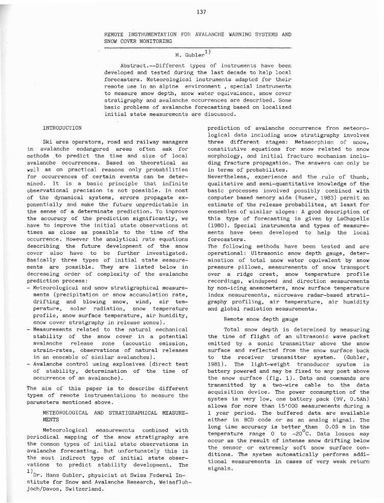
Total snow depth is determined by measuringthe time of flight of an ultrasonic wave packetemitted by a sonic transmitter above the snowsurface and reflected from the snow surface backto the receiver transmitter system. (Gubler,1981). The light-weight transducer system isbattery powered and may be fixed to any post abovethe snow surface (fig. 1). Data and commands aretransmitted by a two-wire cable to the dataacquisi tion device. The power consumption of thesystem is very low, one battery pack (9V, O.SAh)allows for more than lS'OOO measurements during a1 year period. The buffered data are availableei ther in BCD code or as an analog signal. Thelong time accuracy is better 0 than 0.03 m in thetemperature range 0 to -20 C. Data losses mayoccur as the result of intense snow drifting belowthe sensor or extremely soft snow surface condi tions. The system automatically performs additional measurements in cases of very weak returnsignals.
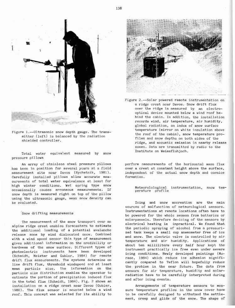
Figure 1.--Ultrasonic snow depth gauge. The transmitter (left) is balanced by the radiationshielded controller.
Total water equivalent measured by snowpressure pillows
An array of stainless steel pressure pillowshas been in position for several years at a fieldmeasurement site near Davos (Rychetnik, 1981).Carefully installed pillows allow accurate measurements of total water equivalence at least forhigh winter conditions. Wet spring type snowoccasionally causes erroneous measurements. Ifsnow depth is measured right on top of the pillowusing the ultrasonic gauge, mean snow density canbe evaluated.
Snow drifting measurements
The measurement of the snow transport over analpine ridge crest enables forecasters to estimatethe additional loading of a potential avalancherelease zone by wind dislocated snow. Combinedwith a wind speed sensor this type of measurementgives additional information on the erodibility orhardness of the snow surface. Different types ofphotoelectric instruments have been developed(Schmidt, Meister and Gubler, 1984) for remotedrift flux measurements. The systems determine online drift flux, threshold windspeed and at leastmean particle size. The information on theparticle size distribution enables the operator toestimate the portion of precipitation induced fluxin the total flux (Schmidt, 1984). Fig. 2 shows aninstallation on a ridge crest near Davos (Gubler,1980). The flux sensor is mounted below a windroof. This concept was selected for its ability to
138
Figure 2.--Solar powered remote instrumentation ona ridge crest near Davos. Snow drift fluxover the ridge is measured by an electrooptical device mounted below a wind roof behind the cabin. In addition, the installationrecords wind, air temperature, air humidity,global radiation, an index of snow surfacetemperature (mirror on white insulation abovethe roof of the cabin), snow temperature profiles and snow depths on both sides of theridge, and acoustic emission in nearby releasezones. Data are transmitted by radio to theInstitute on Weissfluhjoch.
perform measurements of the horizontal mass fluxover a crest at constant height above the surface,independent of the actual snow depth and corniceformation.
Meteorolological instrumentation, snow temperature profile
Icing and snow accreation are the mainsources of malfunction of meteorological sensors.Instrumentations at remote locations often have tobe powered for the whole season from batteries orsolarpannels. Therefore de-icing of the sensors byelectrical heating is inpractical. We found thatthe periodic spraying of alcohol from a pressurized tank keeps a small cup anemometer free of iceand snow. The electric valve is controlled by airtemperature and air humidity. Applications ofabout ten milliliters every half hour kept theinstrument practically ice free even under severeicing conditions. Newly developed paintings (Murase, 1984) which reduce ice adhesion significantly compared to Teflon will hopefully reducethe problem in the near future. The data fromsensors for air temperature, humidity and solarradiation have to be carefully interpreted duringand after icing events.
Arrangements of temperature sensors to measure temperature profiles in the snow cover haveto be carefully designed to withstand the settlement, creep and glide of the snow. The shape of
the sensors has to guarantee good contact with thesnow at all times. If settlement is the predominant deformation of the snow cover an arrangement of knife-blade shaped sensors cutting thesnow cover vertically, proved to be reliable. Ifthe sensors have to be mounted in a steep slopecone shaped sensors orientated slope upwardsshowed good results.
Indexing surface hoar development
A direct measurement of surface hoar development is very difficult. But surface hoar andprowder snow layers may determine the stability ofthe following new snow layers. Emission of longwave radiation from the snow surface into spaceduring clear weather periods causes the cooling ofthe snow surface below the ambient air temperature. Resulting high temperature gradients ina soft surface layer allow for the development ofpowder snow by high gradient metamorphism (Pulverschnee). If'water vapor pressure in the air at thesurface reaches or exceeds the equilibrium vaporpressure of ice at the actual surface temperature,crystal growth at the surface is greatly enhanced.Field experiments have shown that the long waveemissivity of a simple bathroom mirror duringnight time compares well with the correspondingemissivity of the snow surface. The mirror shouldbe well insulated on the back. If the mirror istilted toward the south, snow and rime slide offthe mirror heated by the sun during the day. Fig.2 shows the test mirror. Fig. 3 indicates therange of conditions indexed by the mirror assemblyfavorable for surface hoar development.
7,....,uo.........
Figure 3.--Range of conditions favorable for surface hoar development indexed by the mirrorassembly.
139
FMCW - Microwave radar
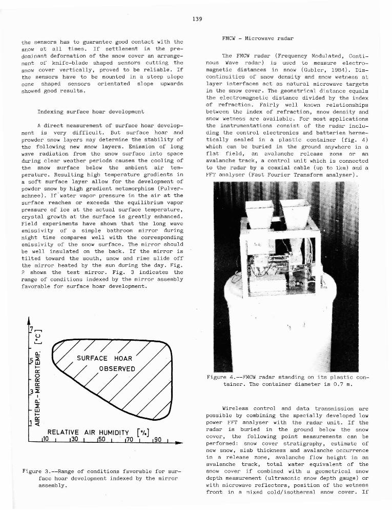
The FMCW radar (Frequency Modulated, Continous Wave radar) is used to measure electromagnetic distances in snow (Gubler, 1984). Discontinuities of snow density and snow wetness atlayer interfaces act as natural microwave targetsin the snow cover. The geometrical distance equalsthe electromagnetic distance divided by the indexof refraction. Fairly well known relationshipsbetween the index of refraction, snow density andsnow wetness are available. For most applicationsthe instrumentations consist of the radar including the control electronics and batteries hermetically sealed in a plastic container (fig. 4)which can be buried in the ground anywhere in aflat field, an avalanche release zone or anavalanche track, a control unit which is connectedto the radar by a coaxial cable (up to lkm) and aFFT analyser (Fast Fourier Transform analyser).
Figure 4.--FMCW radar standing on its plastic container. The container diameter is 0.7 m.
Wireless control and data transmission arepossible by combining the specially developed lowpower FFT analyser with the radar unit. If theradar is buried in the ground below the snowcover, the following point measurements can beperformed: snow cover stratigraphy, estimate ofnew snow, slab thickness and avalanche occurrencein a release zone, avalanche flow height in anavalanche track, total water equivalent of thesnow cover if combined with a geometrical snowdepth measurement (ultrasonic snow depth gauge) orwith microwave reflectors, position of the wetnessfront in a mixed cold/isothermal snow cover. If
140
__ -. KG/1'"lc
,..
lOOOllHz
v1'il7.2
D
Marker F"'"'I1J"oz Diet. 9"'" Diet. bw-A 1.2OOe IJ3 D. 000e 00-2. DIIl<rll3B 5.52IJe IJ3 1.6OOe 00 1.596e 00
""""ev. d13VJ 1.6Oe-01 Scf 1.45<1 00ConvCHz/mJ 2. 17e IJ3e'(lce) 3.12 e'(e,..,w) 1.$dene ctkglm3J 2.928 O2tkg1l1l2J 4.67e 02dena. """". D. 00e 00 diet. air 50 55e-01Vol%H20 0.00e 00 e'colc"""'w) 1.55
D"I
"..'
• Legend., 6: ""RWw
", Ww
+ II ;>5%
0 5%>(', ';0 1%
X (', <: 1%
II
i:~\11
100 ?00 3\1~ Y00 ~00 600>IRTfREQU 'VRLEN<:E BY WE I GH 1NG WI.;
K(i/l'1:~
~-';(~(i]l
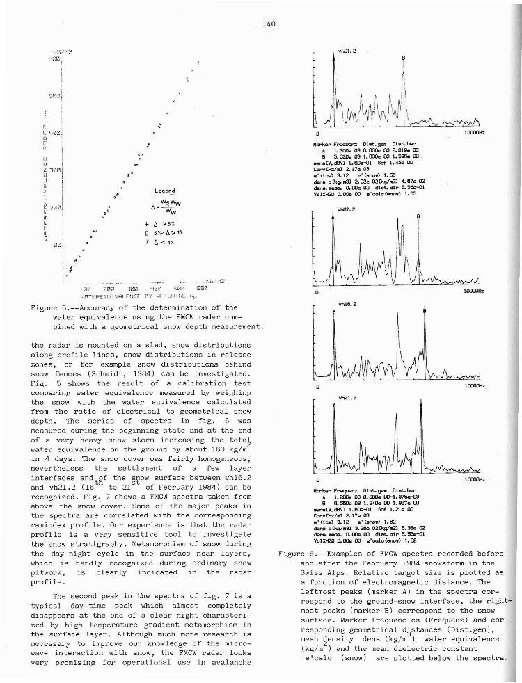
Figure 6.--Examples of FMCW spectra recorded beforeand after the February 1984 snowstorm in theSwiss Alps. Relative target size is plotted asa function of electromagnetic distance. Theleftmost peaks (marker A) in the spectra correspond to the ground-snow interface, the rightmost peaks (marker B) correspond to the snowsurface. Marker frequencies (Frequenz) and corresponding geometrical d~stances (Dist.gem),mean ~ensity dens (kg/m) water equivalence(kg/m ) and the mean dielectric constante'calc (snow) are plotted below the spectra.
Figure 5.--Accuracy of the determination of thewater equivalence using the FMCW radar combined with a geometrical snow depth measurement.
the radar is mounted on a sled, snow distributionsalong profile lines, snow distributions in releasezones, or for example snow distributions behindsnow fences (Schmidt, 1984) can be investigated.Fig. 5 shows the result of a calibration testcomparing water equivalence measured by weighingthe snow with the water equivalence calculatedfrom the ratio of electrical to geometrical snowdepth. The series of spectra in fig. 6 wasmeasured during the beginning state and at the endof a very heavy snow storm increasing the tota~
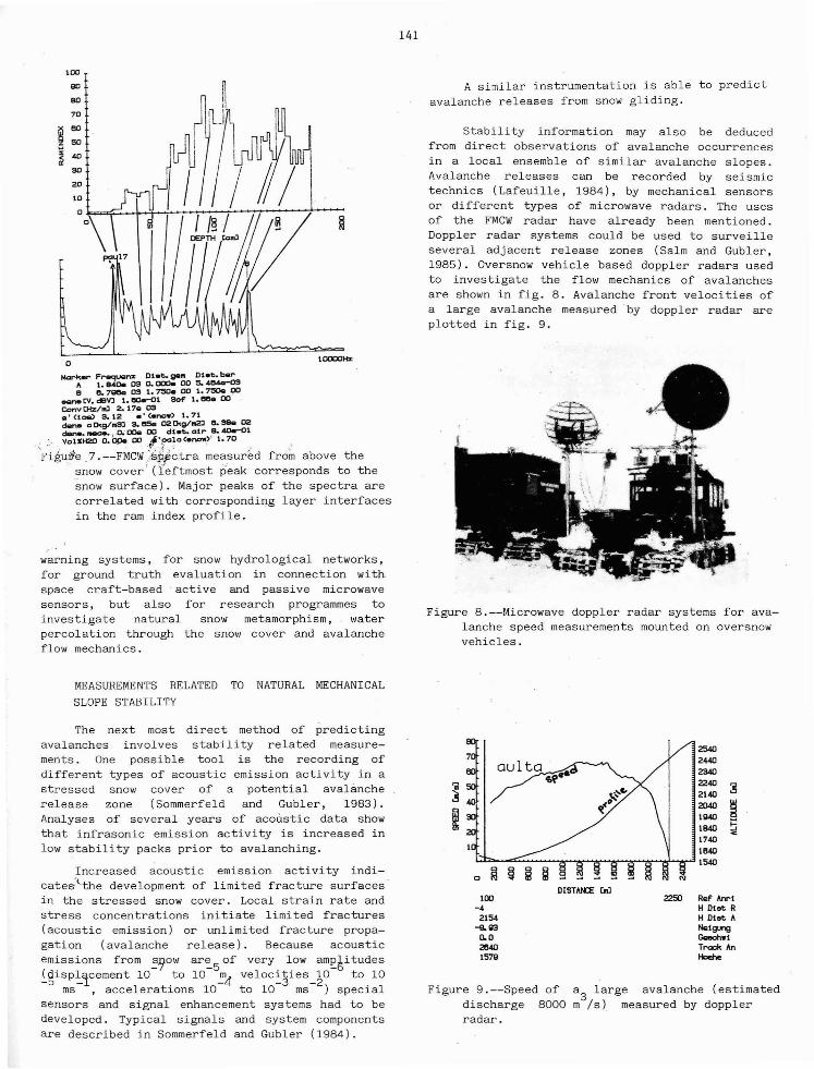
water equivalence on the ground by about 160 kg/min 4 days. The snow cover was fairly homogeneous,nevertheless the settlement of a few layerinterfaces andtgf the ~~ow surface between vh16.2and vh21.2 (16 to 21 of February 1984) can berecognized. Fig. 7 shows a FMCW spectra taken fromabove the snow cover. Some of the major peaks inthe spectra are correlated with the correspondingramindex profile. Our experience is that the radarprofile is a very sensi ti ve tool to investigatethe snow stratigraphy. Metamorphism of snow duringthe day-night cycle in the surface near layers,which is hardly recognized during ordinary snowpi twork, is clearly indicated in the radarprofile.
The second peak in the spectra of fig. 7 is atypical day-time peak which almost completelydisappears at the end of a clear night characterized by high temperature gradient metamorphism inthe surface layer. Although much more research isnecessary to improve our knowledge of the microwave interaction with snow, the FMCW radar looksvery promising for operational use in avalanche
vhlB. 2
D
vh21.2
D
M<rker F'""'l""oz Dlet.9"" Dlet.barI. 200e IJ3 D. DOOe 00-1. Q75<r03
B B. 5llOe IJ3 I. Q4Qe 00 I. Q37e 00"""" ev. d13VJ I. 6Oe-0l Scf I. 21" 00ConvCHz/oLl 2.17.. IJ3.. ' (Ice) 3.12 e' (enow) 1.62d<lnectkglll3J3.2Ile02tkg1l12JB.33<l02dane. _ 0. roe 00 diet. air 50 55e-01Vol%H20 o.aoe 00 .. 'colc(enow) 1.62
lOOOllHz
lOOOllHz
141
l0000Hz
100
90
eo
oMark.... Fl"'8qU'lnx Dt_t. 98111 Diet. bel,..
" 1. e.oo. 09 0. 000oo 00 S. 4fl4<I-()Se e. 7_ 09 1.75Oe 00 1.75Oe00.
___ tv. dBVJ 1.!lOr"<l1 _ 1. _ 00
ConvDtz/l'IJ 2.17.. 09a' Cta&> S.12 .' (~.) 1.71dene oO<g/1IlSJ s. _ 020<g/1llZl e. Slle 02dane..-.ae. ,'Ch DOe 00 diet.. atr ~ 4Oe-Ol
, VolSH20 6.~ OO,"fXJ_~O(.now,)·, 1.70 .
'Fiiu~e.7.--FMCWj$ff~tra measured fr6~ above thesnow cover (leftmost peak corresponds to thesnow surface). Major peaks of the spectra arecorrelated with corresponding layer interfacesin the ram index profile.
warning systems, for snow hydrological networks,for ground truth evaluation in connection withspace craft-based active and passive microwavesensors, but also for research programmes toinvestigate natural snow metamorphism, waterpercolation through the snow cover and avalancheflow mechanics.
A similar instrumentation is able to predictavalanche releases from snow gliding.
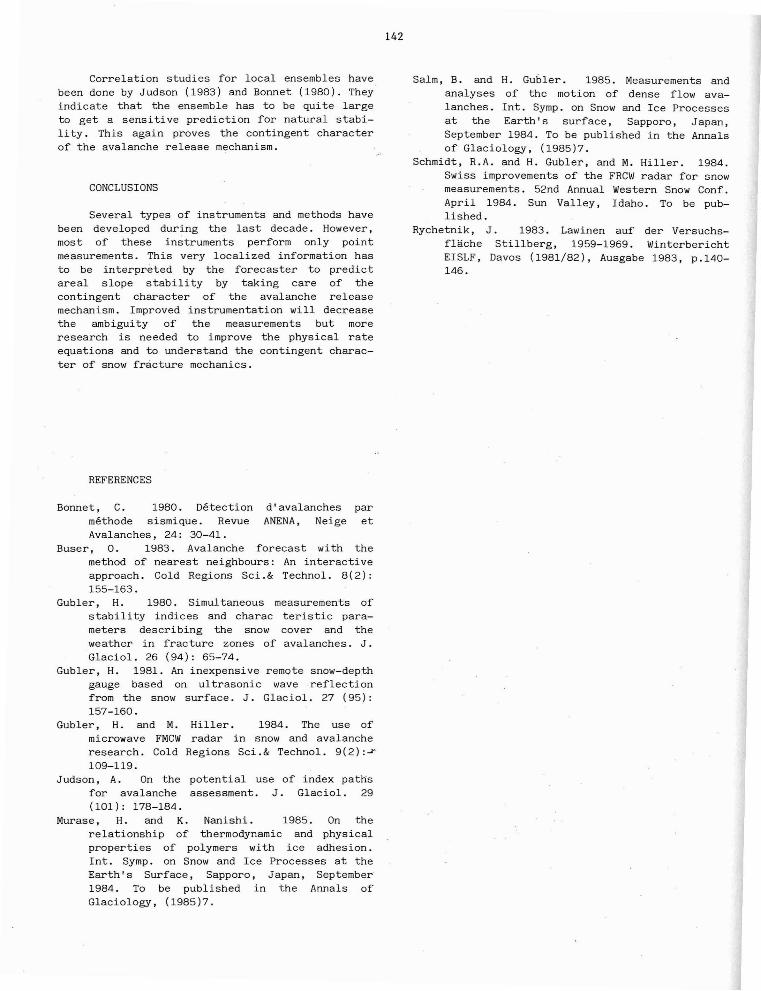
Stability information may also be deducedfrom direct observations of avalanche occurrencesin a local ensemble of similar avalanche slopes.Avalanche releases can be recorded by seismictechnics (Lafeuille, 1984), by mechanical sensorsor different types of microwave radars. The usesof the FMCW radar have already been mentioned.Doppler radar systems could be used to surveilleseveral adjacent release zones (Salm and Gubler,1985). Oversnow vehicle based doppler radars usedto investigate the flow mechanics of avalanchesare shown in fig. 8. Avalanche front velocities ofa large avalanche measured by doppler radar areplotted in fig. 9.
Figure 8.--Microwave doppler radar systems for avalanche speed measurements mounted on oversnowvehicles.
MEASUREMENTS RELATED TO NATURAL MECHANICAL
SLOPE STABILITY
Figure 9.--Speed of a3
large avalanche (estimateddischarge 8000 m Is) measured by dopplerradar.
22SO Ref hnrlH Dlee RH Dlee "NQlgungGQechwtTrack linHoelle
DISTANa: UlJ
254024-4023402240214020401940194017401840
~'"""--::;:.....~~..........,........,~ ....................,.........*~~ 1540
lOll-4
2154-ll.1l30.028401579
The next most direct method of predictingavalanches involves stability related measurements. One possible tool is the recording ofdifferent types of acoustic emission activity in astressed snow cover of a potential avalancherelease zone (Sommerfeld and Gubler, 1983) .Analyses of several years of acoustic data showthat infrasonic emission activity is increased inlow stability packs prior to avalanching.
Increased acoustic emission activity indicates'the development of limited fracture surfacesin the stressed snow cover. Local strain rate andstress concentrations initiate limited fractures(acoustic emission) or unlimited fracture propagation (avalanche release) . Because acousticemissions from "!.r;ow ar~5 of very low am!:Si tudesigisP~1cement 10 to 10 ~4 veloc~jies_~O to 10
ms ,accelerations 10 to 10 ms ) specialsensors and signal enhancement systems had to bedeveloped. Typical signals and system componentsare described in Sommerfeld and Gubler (1984).
Correlation studies for local ensembles havebeen done by Judson (1983) and Bonnet (1980). Theyindicate that the ensemble has to be quite largeto get a sensitive prediction for natural stability . This again proves the contingent characterof the avalanche release mechanism.
CONCLUSIONS
Several types of instruments and methods havebeen developed during the last decade. However,most of these instruments perform only pointmeasurements. This very localized information hasto be interpreted by the forecaster to predictareal slope stability by taking care of thecontingent character of the avalanche releasemechanism. Improved instrumentation will decreasethe ambiguity of the measurements but moreresearch is needed to improve the physical rateequations and to understand the contingent character of snow fracture mechanics.
REFERENCES
Bonnet, C. 1980. Detection d'avalanches parmethode sismique. Revue ANENA, Neige etAvalanches, 24: 30-41.
Buser, O. 1983. Avalanche forecast with themethod of nearest neighbours: An interactiveapproach. Cold Regions Sci.& Technol. 8(2):155-163.
Gubler, H. 1980. Simultaneous measurements ofstabili ty indices and charac teristic parameters describing the snow cover and theweather in fracture zones of avalanches. J."Glaciol. 26 (94): 65-74.
Gubler, H. 1981. An inexpensive remote snow-depthgauge based on ultrasonic wave reflectionfrom the snow surface. J. Glaciol. 27 (95):157-160.
Gubler, H. and M. Hiller. 1984. The use ofmicrowave FMCW radar in snow and avalancheresearch. Cold Regions Sci.& Technol. 9(2):~
109-119.Judson, A. On the potential use of index paths
for avalanche assessment. J. Glaciol. 29(101): 178-184.
Murase, H. and K. Nanishi. 1985. On therelationship of thermodynamic and physicalproperties of polymers with ice adhesion.Int. Symp. on Snow and Ice Processes at theEarth's Surface, Sapporo, Japan, September1984. To be published in the Annals ofGlaciology, (1985)7.
142
Salm, B. and H. Gubler. 1985. Measurements andanalyses of the motion of dense flow avalanches. Int. Symp. on Snow and Ice Processesat the Earth's surface, Sapporo, Japan,September 1984. To be published in the Annalsof Glaciology, (1985)7.
Schmidt, R.A. and H. Gubler, and M. Hiller. 1984.Swiss improvements of the FRCW radar for snowmeasurements. 52nd Annual Western Snow Conf.April 1984. Sun Valley, Idaho. To be published.
Rychetnik, J. 1983. Lawinen auf der Versuchsflache Stillberg, 1959-1969. WinterberichtEISLF, Davos (1981/82), Ausgabe 1983, p.140146.