1/37 water-sensitive design of open space systemslima-water.de/documents/enemcova_dnai2012.pdf ·...
TRANSCRIPT

Water-Sensitive Design of Open Space SystemsEcological Infrastructure Strategy for Metropolitan Lima, Perú
Dipl.-Ing. Eva Nemcova
Team:Prof. Antje Stokman Dr. Bernd Eisenberg MSc. Arch. Rossana Poblet
Research project LiWa (Lima Water): „Sustainable Water and Wastewater Management in Urban Growth Centres Coping with Climate Change - Concepts for Lima Metropolitana (Perú)“ - (2008 - May 2013)
Integrated urban planning strategies and planning tools (May 2011 - May 2013)Institute of Landscape Planing and Ecology
Project team Lima: L. Miranda, L. Zilbert, R.Torres (NGO FCPV), J. Espinola, L. Jara, C. Santisteban (Instituto Metropolitano de Planificación), J. Moscoso (Consultant), R. Miglio and Víctor Peña (Universidad Nacional Agraria La Molina), J. Beerhalter (MVCS, OMA)
1/37
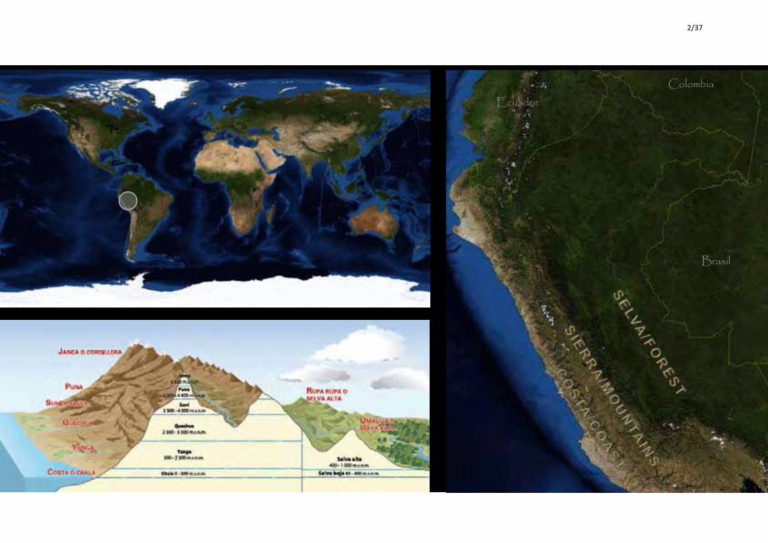
INTRODUCTION | LOCATION PERU
Institut für Landschaftsplanung und Ökologie | Fakultät für Architektur und StadtplanungUniversität Stuttgart
Rossana Poblet
EcuadorColombia
Brasil
Chile
Bolivia
Ar e a _ 1 . 2 8 5 . 2 1 5 , 6 K m 2 | Po p u l a t i o n _ 2 8 . 2 2 0 . 7 6 4 ( 2 0 0 7 ) O f f i c i a l L a n g u a g e s _ C a s t e l l a n o ( 8 0 %) _ Q u e c h u a ( 1 6 %) _Ay m a r a ( 2 %) _ + 4 1 i n d i g e n o u s l a n g u a g e s
2/37

The desire to increase green areas. 5,4 l / m2 / day
3/37

Many parks and road greenery are irrigated with potable water or groundwater.
4/37

Population: 8,5 million(INEI, 2007)
Population growth rate: 2,1 annually (INEI, 2002, 2005, 2006)
Annual rainfall: 9mm
Green areas: 4500 ha (2012)
Area: 2,801.63 km2 (INEI, 2011)
How do we create an open space system that improves the disbalanced urban water cycle?
Credit: [email protected]
5/37
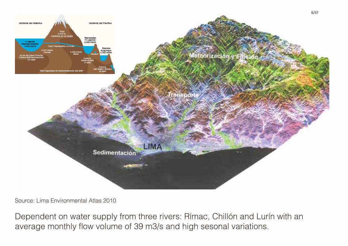
Dependent on water supply from three rivers: Rímac, Chillón and Lurín with an average monthly flow volume of 39 m3/s and high sesonal variations.
Source: Lima Environmental Atlas 2010
6/37

River WITHOUT water June - October, dry season in the Andean mountains
River WITH waterDecember - April, rain season in the Andean mountains
7/37

Historical relationship between agricultural landscape, rivers and settlements.
Institute for Landscape Planning and Ecology, Faculty for Architecture and Urban Planning
UAC Creative Workshop Transferability: City profile Lima04. Mai 2012, Berlin
En el proceso de formación de los Valles Agrícolas
en la costa desértica, un rol protagónico le corresponde
al desarrollo de sistemas de irrigación artificial.
Agricultural production in Lima is depended on irrigation -Historical irrigation channel system in the pre-Inka times
(Canziani 2009)
Source:Canziani (2009)
8/37

Ges$
ón so
sten
ible
del
agu
a y
las a
guas
resid
uale
s en
cent
ros d
e cr
ecim
ient
o ur
bano
afro
ntan
do e
l cam
bio
clim
á$co
Conc
epto
s par
a Li
ma
Met
ropo
litan
a (P
erú)
-‐ Estrategias integradas de planificación urbana y herram
ientas de planificación PT9
Ins:tuto de Planificación Paisajís:ca y Ecología, Universidad de StuBgart
Ins:tute for Landscape Planning and Ecology, Faculty for Architecture and Urban Planning
ILPÖ
Lima 2011
Lima 1957
Distribución insostenible y uso de recursos de agua
Unsu
stai
nabl
e di
strib
u$on
and
use
of w
ater
reso
urce
s Desarrollo Urbano Insostenible
Crec
imie
nto
urba
no in
cont
rola
ble,
más
de
1 m
illon
de
pers
onas
no
$ene
n ac
ceso
a su
ficie
nte
agua
y
sane
amie
nto
siend
o el
agu
a po
tabl
e
usad
a pa
ra ir
rigac
ión
y só
lo e
l 10%
de la
s agu
as re
sidua
les s
on
reus
adas
(SW
ITCH
). Unsustainable distribu1on and use
of water resources
Unco
ntro
lled
urba
n gr
owth
, mor
e
that
1 m
il pe
ople
do
not h
ave
acce
ss to
suffi
cien
t wat
er a
nd
sani
ta$o
n, d
rinki
ng w
ater
is u
sed
for i
rrig
a$on
and
onl
y 10
% (S
WIT
CH
2010
) of w
aste
wat
er is
re-‐u
sed.
Uncontrolled urban growth, loss of agricultural valleys and chanalisation of rivers
1957 2011
Credit: [email protected]
9/37

Occupation of coastal wetlands followed by water pollutionSource: M. Mamani, MML, Serpar, 2012
10/37

Source: M. Mamani, MML, Serpar, 2012
Disappierence of sesonal biotop loma
11/37

!
!
!
!
!
!
!
!
!
!
!
!
!
!
!
!
!
!
!
!
!
!
!
!
!
!
!
!
!
!
!
!
!
!
!
!
!
!
!
!
!
!
!
!
!
!
!
!
!
LIM
A
RIM
AC
COM
AS
ANC
ON
BREÑ
A
LUR
IN
CALL
AO
VITA
RTE
LA P
UNTA
LA P
ERLA
BARR
ANCO
SAN
LUIS
PUC
USA
NA
SAN
BOR
JA
LA M
OLI
NA
BELL
AVIS
TA
VENT
ANIL
LA
SANT
A R
OSA LO
S O
LIVO
S
SAN
MIG
UEL
CHOR
RILL
OS
CHAC
LACA
YO
PAC
HACA
MA
C
CAR
ABAY
LLO
SANT
A AN
ITA
JESU
S M
ARIA
EL A
GU
STIN
O
SAN
BAR
TOLO
PUN
TA N
EGR
A
CIEN
EGU
ILLA
PUEN
TE P
IEDR
A
PUN
TA H
ERM
OSA
VILL
A EL
SAL
VAD
OR
MAG
DALE
NA
DEL
MAR
LUR
IGAN
CHO
-CHO
SIC
A
SAN
MAR
TIN
DE
POR
ES
SAN
JUAN
DE
LURI
GAN
CHO
SAN
JUAN
DE
MIR
AFLO
RES
VILL
A M
ARIA
DEL
TR
IUN
FO
CAR
MEN
DE
LA L
EGU
A R
EYN
OSO
LINC
E SUR
QUI
LLO
SAN
ISID
RO
MIR
AFLO
RES
LA V
ICTO
RIA
PUEB
LO L
IBRE
INDE
PEN
DEN
CIA
SANT
IAG
O D
E SU
RCO
SANT
A M
ARI
A D
EL M
AR
76°4
0'0"
W
76°4
0'0"
W
77°0
'0"W
77°0
'0"W
11°40'0"S
11°40'0"S
12°0'0"S
12°0'0"S
12°20'0"S
12°20'0"S
I
ELAB
OR
ADO
:
PLAN
O:
Cart.
: Vict
or I.
Táv
ara
Ma-
SanEV
OLU
CIO
N U
RBA
NA
DE L
A C
IUDA
D D
E LI
MA
ESC
ALA
:
1:200
,000
FUEN
TE:
DNU,
INEI
y E
stud
ios
de
Inves
tigac
ion
Urba
na
LIM
A 1
535
1,
500
hab.
LIM
A 1
615
26,
400
hab.
LIM
A 1
750
56,
600
hab.
LIM
A 1
910
140,
000
hab.
LIM
A 1
940
533,
600
hab.
LIM
A 1
970
2
'541
,300
hab
.
LIM
A 1
981
3
'573
227
hab.
LIM
A 1
995
5
'930
,318
hab
.
LIM
A 2
004
7
'880
,039
hab
.
LIM
A 2
010
8
'219
,116
hab
.
LEYE
NDA
Occupation of vulnerable areas on the slopes of the dry hills
!
!
!
!
!
!
!
!
!
!
!
!
!
!
!
!
!
!
!
!
!
!
!
!
!
!
!
!
!
!
!
!
!
!
!
!
!
!
!
!
!
!
!
!
!
!
!!
!
LIMA
RIMAC
COMAS
ANCON
BREÑA
LURIN
CALLAO
VITARTE
LA PUNTALA PERLA
BARRANCO
SAN LUIS
PUCUSA NA
SAN BORJA
LA MOLINA
BELLAV IS TA
VENTANILLA
SANTA ROSA
LOS OLIVOS
SAN MIGUE L
CHORRILLOS
CHACLACAYO
PACHA CAMA C
CARABAYLLO
SANTA ANITA
JESUS M ARIA
EL AGUSTINO
SAN BARTOLO
PUNTA NEGRA
CIENE GUILLA
PUENTE PIE DRA
PUNTA HERMOSA
VILLA EL SALVADOR
MAGDALENA DEL MAR
LURIGANCHO-CHOSICA
SAN MARTIN DE PORES
SAN JUAN DE LURIGANCHO
SAN JUAN DE MIRAFLORES
VILLA MARIA DEL TRIUNFO
CARMEN DE LA LEGUA REYNOSO
LINCE
SURQUILLO
SAN ISIDRO
MIRAFLORES
LA VICTORIAPUEB LO LIBRE
INDEP ENDENCIA
SANTIAGO DE SURCO
SANTA MA RIA DEL MAR
76°40'0"W
76°40'0"W
77°0'0"W
77°0'0"W
11°4
0'0"
S
11°4
0'0"
S
12°0
'0"S
12°0
'0"S
12°2
0'0"
S
12°2
0'0"
S
I
ELABORADO:
PLANO:
Cart.: Victor I. Távara Ma-San
EVOLUCION URBANADE LA CIUDAD DE LIMA
ESCALA:1:200,000
FUENTE:DNU, INEI y Estudios de
Investigacion Urbana
LIMA 1535 1,500 hab.
LIMA 1615 26,400 hab.
LIMA 1750 56,600 hab.
LIMA 1910 140,000 hab.
LIMA 1940 533,600 hab.
LIMA 1970 2'541,300 hab.
LIMA 1981 3'573227 hab.
LIMA 1995 5'930,318 hab.
LIMA 2004 7'880,039 hab.
LIMA 2010 8'219,116 hab.
LEYENDA
12/37

81% of the city´s population is connected to the public water supply networkalmost 1 million people without water connection (INEI 2007)
13/37

In the dry season all river water is used for drinking water, ... and dircharged as treated or untreated wastewater into rivers and ocean.
14/37
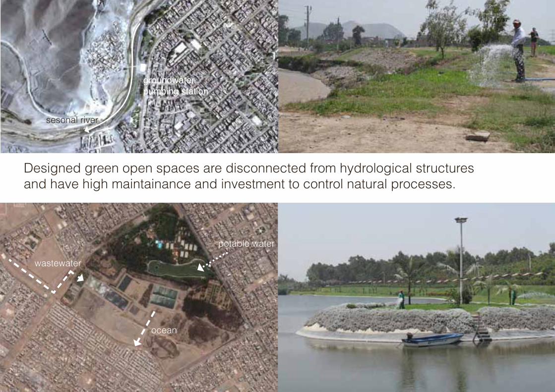
BEYOND THE PARKMÁS QUE UN PARQUE
wastewater
ocean
potable water
sesonal river
groundwater pumping station
Designed green open spaces are disconnected from hydrological structures and have high maintainance and investment to control natural processes.
15/37

BEYOND THE PARKMÁS QUE UN PARQUE
wastewater
ocean
potable water
sesonal river
groundwater pumping station
Lima´s hydrological strutures, water infrastructure and the design of open space need radical rethinking to make urban and natural systems perform in concert with
one another and keep up with the increasing water demand for a growing liveable city.
16/37

Developing concepts for Metropolitan LimaEcological Infrastructure Strategy
WP 7Water Tariff instruments/
Economy
REGIONAL SCALE
WP6WP 5
Trai
ning
and
Cap
acity
bui
ldin
g
MICROESCALE
WP 3Climate modelling and
Water ballance
METROPOLITAN SCALE
MESOESCALE
WP 2LiWa Scenarios
2040
WP 4LiWatool
WP 9.1
Stak
ehol
der P
artic
ipat
ion
LIMA ECOLOGICAL INFRASTRUCTURE STRATEGY (LEIS)
Wat
er S
ensi
tive
Urb
an D
esig
n G
uide
lines
Design Solutions
Pilot Projects
Lima Ecological Infraestructure Strategy (LEIS)
Principles at city level for a Water Sensitive Urban
Development
Lim
a Ec
olog
ical
Infr
astr
uctu
re S
trat
egy
Tool
(LEI
S To
ol)
Urban water cycle facilitates the open
space system
Open space system can help to improve
and protect the water cycle
.. conceptual strategy based on the flows of water and the provision of ecosystem services.
17/37

Principles for water sensitive urban development are harmonised with the Concerted Regional Development Plan (2012-2025)
- GIS database for all instutitions to coordinate actions
Protect, develop and implement open space system considering availability and integrated management of water resources.
Protect and consolidate agricultural land and add value to improve ecosystem performance
Transform high risk areas as part of the ecological infrastructure.
Promote water sensitive urban development that considers water catchment, saving, treatment and reuse of water in the city
18/37

WP 7Water Tariff instruments/
Economy
REGIONAL SCALE
WP6WP 5
Trai
ning
and
Cap
acity
bui
ldin
g
MICROESCALE
WP 3Climate modelling and
Water ballance
METROPOLITAN SCALE
MESOESCALE
WP 2LiWa Scenarios
2040
WP 4LiWatool
WP 9.1
Stak
ehol
der P
artic
ipat
ion
LIMA ECOLOGICAL INFRASTRUCTURE STRATEGY (LEIS)
Wat
er S
ensi
tive
Urb
an D
esig
n G
uide
lines
Design Solutions
Pilot Projects
Lima Ecological Infraestructure Strategy (LEIS)
Principles at city level for a Water Sensitive Urban
Development
Lim
a Ec
olog
ical
Infr
astr
uctu
re S
trat
egy
Tool
(LEI
S To
ol)
Ecological Infrastructure Strategy for Lima
1
19/37

Water demand study
Gestión sostenible del agua y las agas residuales en centros de crecimiento urbano afrontando el cambio climáto‐ Conceptos para Lima Metropolitana (Perú) ‐ Estrategias integradas de planificación urbana y herramientas de planificación
Instituto de Planificación del Paisaje y Ecología, Universidad de StuttgartInstitute of Landscape Planning and Ecology (ILPE)
Estructura EcológicaSistemas espacial y
funcionalmente integradas, compuestas de los ecosistemas
naturales, semi‐naturales y artificiales
La INFRAESTRUCTURA ECOLOGICA construye sobre la Estructura Ecológica de la ciudad
Para qué sirve la Herramienta LEIS
Gestión sostenible del agua y las agas residuales en centros de crecimiento urbano afrontando el cambio climáto‐ Conceptos para Lima Metropolitana (Perú) ‐ Estrategias integradas de planificación urbana y herramientas de planificación
Instituto de Planificación del Paisaje y Ecología, Universidad de StuttgartInstitute of Landscape Planning and Ecology (ILPE)
Source: Green Inventory Serpar, Sept. 2012 Jose Mamani Source: Green Inventory Serpar, Sept. 2012Source: geoeye foundation, Jan. 2012
To green all as park registered areas the water demand would increase dramaticaly.
20/37

77 % of population connected to sewerage network
18 wastewater treatment plants (treating,however, only a small fraction of the wastewater production)
10% reused for irrigation of green areas (Moscoso 2011)
Water availability study - City as a water source
Different areas offer different sources of water: natural or man-made water sources and other areas with no water source.
21/37

Hydro-urban units
Combining information layers about natural and man-made water sources and urban structures, which are key to identifing site-specific suitable design solutions.
Linking water and open space in different urban settings22/37

WP 7Water Tariff instruments/
Economy
REGIONAL SCALE
WP6WP 5
Trai
ning
and
Cap
acity
bui
ldin
g
MICROESCALE
WP 3Climate modelling and
Water ballance
METROPOLITAN SCALE
MESOESCALE
WP 2LiWa Scenarios
2040
WP 4LiWatool
WP 9.1
Stak
ehol
der P
artic
ipat
ion
LIMA ECOLOGICAL INFRASTRUCTURE STRATEGY (LEIS)
Wat
er S
ensi
tive
Urb
an D
esig
n G
uide
lines
Design Solutions
Pilot Projects
Lima Ecological Infraestructure Strategy (LEIS)
Principles at city level for a Water Sensitive Urban
Development
Lim
a Ec
olog
ical
Infr
astr
uctu
re S
trat
egy
Tool
(LEI
S To
ol)
2
Ecological Infrastructure Strategy for Lima23/37

Understanding urban water cycle and open space design
Survey of 20 cases representing different typologies of open spaceSource: Google Earth, geoeye 2012
river corridor river corridor
river corridor
irrigation channel corridorirrigation channel corridor
street greenerystreet greeneryelectrical lines
metro line
loma biotop
zonal park
zonal park
district park
large private open space - university campus
24/37

Water sensitive design prototypes
solid waste
Green areas (land use, type of vegetation, irrigation demands in dry season and wet season, type of irrigation, source of nutrients, etc.)
Water sources (water quality, quantity)
Aesthetics and ecology of water (visibility, accessibility, bench structure and if and how water is reflected in the design of the open space
Maintenance costs and institutional framework
wastewater
neglected, dangerous area
Existing relationship between water, open space and peopleStudy area: Irrigation channels ChuquitantaSan Martin de Porres Municipality
poor water quality
Open space design providing essential environmental services Green purification corridor
Designing open spaces which purify water, purify wastewater, harvest water from the fog, recycle nutrients, maintain the character of the place, etc.
25/37

WP 7Water Tariff instruments/
Economy
REGIONAL SCALE
WP6WP 5
Trai
ning
and
Cap
acity
bui
ldin
g
MICROESCALE
WP 3Climate modelling and
Water ballance
METROPOLITAN SCALE
MESOESCALE
WP 2LiWa Scenarios
2040
WP 4LiWatool
WP 9.1
Stak
ehol
der P
artic
ipat
ion
LIMA ECOLOGICAL INFRASTRUCTURE STRATEGY (LEIS)
Wat
er S
ensi
tive
Urb
an D
esig
n G
uide
lines
Design Solutions
Pilot Projects
Lima Ecological Infraestructure Strategy (LEIS)
Principles at city level for a Water Sensitive Urban
Development
Lim
a Ec
olog
ical
Infr
astr
uctu
re S
trat
egy
Tool
(LEI
S To
ol)
3
Ecological Infrastructure Strategy for Lima26/37

View from the Cerro El Paraíso towards the industrial area in Callao. Agricultural fields in the Chillón Valley with the Pre-Inca huaca El Paraíso in the foreground.
View from the Hill Santa Cruz towards the river mouth of the Chillón River behind the mountain range in the background.
Demonstration area - Lower Chillón River Watershed27/37

Ecological infrastructure for Lower Chillón River Watershed
Utilisation of local water sources, not drinking water and groundwater.
28/37

Ecological infrastructure for Lower Chillón River Watershed
Water sensitive design prototypes applied in a larger scale create an essential and regenerative infrastructure for the city.
29/37

RIVER
POND
IRRIGATION CHANNEL
GREY WATER
Temporary installations of water sensitive design prototypes / Summerschool 2012
30/37

Needs of the local inhabitants, local knowledge and local materials.
31/37

Phase II: Field Testing Equipment
Aquamerck® Compact Laboratory for Water Testing
Calibration of pH Probe
27
NO
OO
NOO
PO
O
O
O
NH
HH H
muestra 2: puquioSample taken in the middle of the spring, near outlet and shore
11:00 PM
7.1
25.9 !
4.6 !
0.025
25 !
0
0.5
!
!
Water Temperatures are high but not too high to support aquatic life. pH is slightly basic but is within Peru’s limits for water that can be used for irrigation of short- and long-stemmed plants.
Nitrate and Nitrite levels exceed Peru’s limit for water that can be used for irrigation of short- and longstemmed plants.
water sampel 2: spring
puquiospring
N
tomando muestra de agua del puquiotaking water sample from spring
PRUEBA
S DE A
GU
A
Interdisciplinary process for designing of water sensitive open spaces.
Source: K.McElhinney, Master Thesis, 2012, ILPÖ
32/37

Temporary installations of water sensitive design
33/37

Treatment reservoir Wetland park Grey water treatemnt and reuse for Urban agriculture
River dike
Escala 1/100010 20 30 40 50 m
N
Rio Chillon Ecological Park+ Water Dynamics + Flood Protection + Agriculture / Social Activities
Preliminary Design- Site Plan31.07.2012
5
6
4
3
2
1
Typical section: Neighborhood Park - Landside
> Flood event> Extreme flood event
Typical section:Neighborhood Park - Waterside
Flood protection + Recreation + Green area
= one investment= saving water for irrigation and
reducing maintenance of green areas
> Flood event> Extreme flood event
Typical section: Watergardens - Waterside
Water purification + Green area + Recreation = saving cost of water for irrigation of large green areas and
reducing maintenance of green areas, low maintainance intensity of wettlands
Grey water purification + Recreation + Production of agricultural products
+ Care by locals
= saving cost for installation of pipe infrastructure and connection to the public wastewater network= saving maintenance of green areas
Typical section: Open fields - Landside
Water purification + Production of agricultural products
+ Recreation
= saving cost for clean water = saving maintenance of green areas
Reservoir
Constructed wetland
Dam & Esplanade River banks
River banksCommunity Gardens
Lower esplanade
Dam & Esplanade
Constructed wetland
River gardens
Dam & Esplanade
Constructed wetland
Gabion embankment & River walk
Gabion embankment & wetland walk
Rio Chillon
Riprap layer & arid gardens
Riprap layer & arid gardens
Rubble breakwater
River gardens
Dam & Esplanade
Gabion embankment & River walk
Gabion wall
Rio Chillon
Rubble breakwater
ReservoirConstructed wetland
Riprap& arid gardens
Mirador
Esplanade
Gabion wall
River gardens
Rubble breakwater
Rubble breakwater
Rubble breakwater
Rio Chillon
Esplanade
Constructed wetland
River gardens
WWTP effluent
Riprap & arid gardens
Riprap & arid gardens
Riprap & arid gardens
Gabion embankment & River walk
Gabion embankment & River walk
Gabion embankment & wetland walk
Constructed wetland
Community gardens
Esplanade
Park centre
Playing fields
Water plays
Fence
Fence
Lower esplanade
conceptAlternative - A-: Agriculture drawings:
Strategic project - Seasonal River Park at the Chillón River
flux. Dieterle Landschaftsarchitektur
34/37

Strategic project - Lomas park... park captures water from the fog
Ege M., Diploma Thesis, 2012, ILPÖ
35/37

While designing a place/area we alter the water flows. A planned intervention, based on the understanding of the urban water cycle and natural processes, initiates new natural process with new ecosystem services for the city.
Such places can provide services such as water purification, wastewater purification, water harvesting from fog and nutrients recycling, and thus create an essential and regenerative infrastructure for the city.
36/37

Water-Sensitive Design of Open Space SystemsEcological Infrastructure Strategy for Metropolitan Lima, Perú
Dipl.-Ing. Eva [email protected]
Prof. Antje Stokman Dr. Bernd Eisenberg MSc. Arch. Rossana Poblet
Research project LiWa (Lima Water)http://www.lima-water.de/
Integrated urban planning strategies and planning tools (May 2011 - May 2013)
Institute of Landscape Planing and EcologyUniversity of Stuttgart, Germanyhttp://www.ilpoe.uni-stuttgart.de/
37/37