15: an integrated hydrological modeling system for high-resolution
TRANSCRIPT

1
DISTRIBUTION STATEMENT A. Approved for public release; distribution is unlimited.
An Integrated Hydrological Modeling System for High-Resolution Coastal Applications
Teddy R. Holt
Naval Research Laboratory Monterey, CA 93943-5502
phone: (831) 656-4740 fax: (831) 656-4769 email: [email protected]
Award Number: N0001415WX01059 LONG-TERM GOALS The long-term goal of this project is to develop, test, and transition a new prototype high-resolution coupled hydrological modeling capability within the Coupled Ocean/Atmosphere Mesoscale Prediction System®1 (COAMPS). The proposed Navy capability will leverage ongoing and new hydrological community efforts to create an integrated, generalized Earth System Modeling Framework (ESMF)-based system compatible with current state-of-the-art land surface (LS) and hydrological systems, such as the NASA Land Information System (LIS) / Weather Research and Forecasting (WRF) Hydrological model (WRF-Hydro) and NASA LIS / North American Land Data Assimilation System (NLDAS). This initial capability will be obtained through the integration/development and testing at high-resolution of the linked LS hydrological system and the atmospheric moist physics scheme within the coupled air-land-ocean COAMPS framework. This linkage will provide a new capability for accurately quantifying the impact of coastal terrestrial hydrological events on the LS at high-resolution, such as flash flooding, beach erosion, and LS traffic-ability. The modular ESMF-based structure will facilitate inter-comparison with other LS, hydrological modules and moist physics/cloud schemes within LIS and WRF-Hydro. This new coupled system will serve as the baseline development and validation of important coupled atmospheric-LS hydrological processes and will establish the foundation necessary for a fully coupled land-ocean system that would include interactions with marine processes, such as fresh-water stream inflow affecting near-coast water density vertical structure and transport of riverine sediment impacting local bathymetry and water clarity. OBJECTIVES The objective of this project is to provide a new baseline capability for Naval LS-hydrological modeling by: i) quantifying the impact of the water cycle budget on LS dynamics, via the interactive feedback of LS hydrology within the COAMPS land-surface model (LSM) framework; ii) quantifying the impact of enhanced cloud-microphysical processes via linkage with COAMPS moist physics parameterizations; and iii) quantifying the feasibility of a “generalized” hydrological component within the COAMPS framework. The new coupled system will be linked ultimately to tactical decision aids (TDAs) for military operations impacted by LS hydrology. Existing ESMF-based hydrological model (e.g., LIS and WRF-Hydro) development and capabilities will be leveraged with previous LSM,
1 COAMPS is a registered trademark of the Naval Research Laboratory.

2
LS data assimilation (DA), and moist physics COAMPS model development to develop a linked LS hydrology-moist physics system. This development is a critical step before such a system is suitable for testing as a fully interactive coupled air-land system with the ocean. The first element is to develop and foster interagency collaboration by organizing a hydrology working group among the various research centers, as well as an annual workshop to address scientific and organization issues related to hydrological community modeling. The research teams at NASA-Goddard Space Flight Center (GSFC), National Center for Atmospheric Research (NCAR), National Centers for Environmental Prediction (NCEP) Environmental Modeling Center (EMC), US Army Corps of Engineers-Cold Regions Research and Engineering Laboratory (USACE-CRREL), and National Oceanic and Atmospheric Administration/Cooperative Institue for Research in Environmental Sciences (NOAA/CIRES) are co-principal investigators on this proposal and will be integral members of the working group and workshop. APPROACH The technical approach is to a) develop a generalized coupled hydrology analysis and forecast software infrastructure within COAMPS by leveraging the existing COAMPS coupling framework (including LIS) as well as new/developing infrastructure for LIS (at NASA-GSFC and NCEP EMC) and WRF-Hydro (at NCAR). The current COAMPS coupling infrastructure development at NRL led by S. Chen (NRL-MRY) and T. Campbell (NRL-SSC) will be leveraged and expanded, in collaboration with LIS scientists (C. Peters-Lidard) and CIRES scientists (C. DeLuca), experts in ESMF coupling. For the analysis system, we would develop a new stand-alone hydrological analysis system (similar to the LIS framework) that would provide integrated and consistent land/atmosphere/hydrology initial conditions. The development of generalized hydrological data pre-processing (I/O) software and datasets for model simulations/validation would be an integral component. For the forecast system, we will leverage existing infrastructure from WRF-Hydro (D. Gochis, NCAR) to develop a similar “multi-grid” routing architecture in which the system runs on two grids. The routing runs on a "fine" grid (e.g., 500m-100m), with a “coarse” grid (4km-1km) used to update soil moisture states which are then used to initialize the COAMPS LSM. For each of these components we will interact with partners to leverage their development and add interfaces that can provide a similar generalized capability; b) conduct extensive high-resolution (~1-km) validation of COAMPS precipitation forecast skill for one to two catchments of interest, focusing on validation of observations (precipitation; soil moisture) using specific hydrology models. The specific catchments for validation will initially be data sets over the US (CONUS) near coastal areas. Potential datasets are those available from the USGS National Water Information System (NWIS) or field programs such as CalWater2 (http://cw3e.ucsd.edu/). NWIS is a large collection of data and information on US water resources, containing current and historical water data from more than 1.5 US million sites (hosted by the USGS Water Data for the Nation web site: http://waterdata.usgs.gov/nwis/). In conjunction with this hydrological data, we will obtain Stage IV precipitation data and individual rain gauge network data for the same CONUS watershed catchments to be used as validation of high-resolution COAMPS forecasts. We will then feedback precipitation validation knowledge into tuning/improvements of COAMPS microphysics and cloud parameterizations. We will investigate water cycle budget terms and their LS feedback via the LSM and develop improved hydrology-atmosphere linkage (via surface fluxes). These high-resolution simulations will employ a standard (default) configuration of the hydrology system (e.g. WRF-Hydro) using default components of subsurface flow, over land flow, and base-flow, in both one-way (uncoupled) and two-way (coupled) mode. The goal is to establish a baseline configuration requiring minimal manipulation of either input data or model components. We envision significant

3
collaborations with partners (e.g., M. Ek, NCEP EMC and J. Eylander, USACE CRREL) on validation and process studies for the catchment simulations; and c) develop a new COAMPS generalized re-locatable hydrological capability. Methodology and prototype software within COAMPS will be developed to provide a globally re-locatable solution based on stream flow observations for one to two target catchments, based on prominent catchment characteristics mined from hydrology datasets. The process is designed to be an iterative learning one to refine identification of important parameters using parameter estimation techniques. The initial configuration and model solution may be one that is limited in its accuracy and extendibility, but the goal is to eventually remove geographical site-dependence by providing a generalized solution that captures a large majority of the variability in stream flow. Extensive testing and validation will be conducted using NWIS CONUS data sets. The ultimate goal is to have a system useful for less well characterized regions constrained mostly by satellite data globally. WORK COMPLETED Work completed on the technical tasks includes: a) Kickoff meeting: A kickoff meeting was organized and conducted, led by NRL-Monterey, at ONR, Washington DC 23-24 February 2015. Approximately 30 people attended, and relationships were developed and collaborations were discussed. A case study design was agreed upon and specific scientific tasks were coordinated; b) Legal agreements: Legal Memoranda of Agreements (MOA’s) were drafted to facilitate code sharing among the research partners. The MOA between NRL and NOAA/CIRES has been finalized and is awaiting signatures from the two agency leads. Other MOA’s are still in the NRL legal office; c) Development of a generalized coupled hydrology analysis and forecast software infrastructure within COAMPS: Work related to developing a generalized coupled capability has begun by leveraging NOAA coupling development related to LIS and WRF-Hydro coupling within a coupled National Unified Operational Prediction Capability (NUOPC) system (NOAA Environmental Modeling System, NEMS Region v0.1). NUOPC linkage has been developed by NOAA for both WRF-Hydro and LIS to allow these components to work in NUOPC-compliant systems. This work is the precursor for integration into the COAMPS Hydro system. In coordination with this NOAA effort, HPC computer accounts are being created for NOAA personnel and code transfer is being readied to facilitate coupled code development between NRL and NOAA. Meetings have been held between NRL and NOAA personnel to develop a coupled architecture plan. The plan is to first get WRF-Hydro and LIS running as separate NUOPC components in ESMF and transfer those to NRL where a public repository will be created. In that repository, the team will adapt the NUOPC-compliant COAMPS driver to run with either a real or stub atmosphere. The first coupled milestone will be verifying all the separate components running standalone in the driver. At this point we would then switch over to the NRL internal repository to have an active atmosphere, to be tested on real data cases; and d) Conduct extensive high-resolution COAMPS case study: The tropical cyclone cases of Irene and Lee (August-September 2011) were chosen as case studies. These cases were chosen because of their impact on coastal watersheds in the US and the relative abundance of meterological and hydrological data for initialization and validation (see Figure 1). Initial COAMPS simulations have been conducted for Hurricane Irene for two different configurations: one in which global LIS data (~25-km resolution) is interpolated to the COAMPS domains for soil-state initialization, and one in which the NASA LIS sytem is used to spin up the soil state on the native COAMPS domains to be used as initial conditions.
4
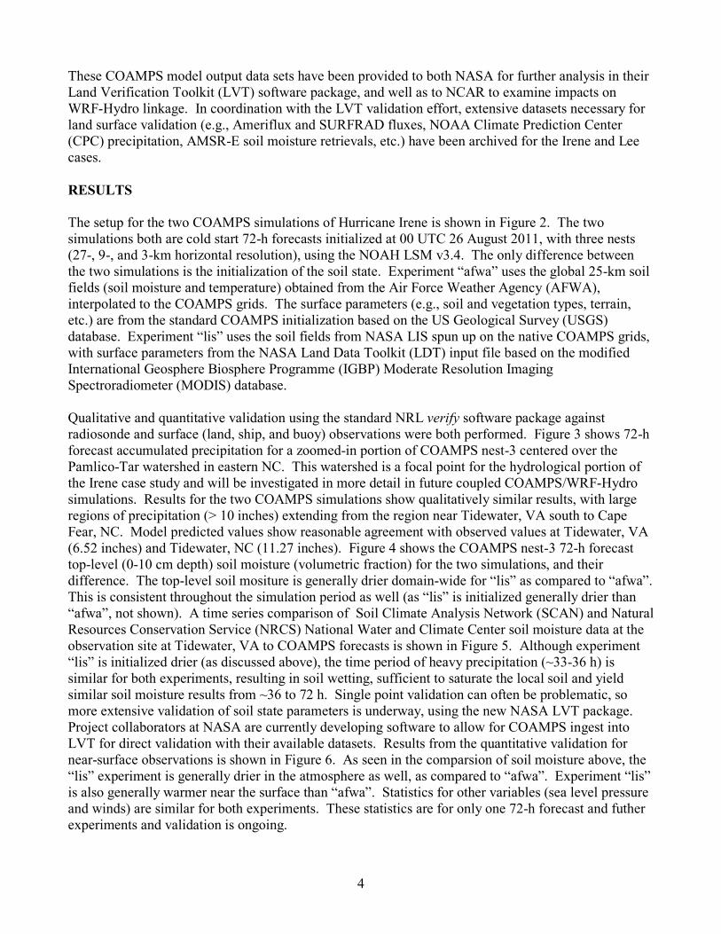
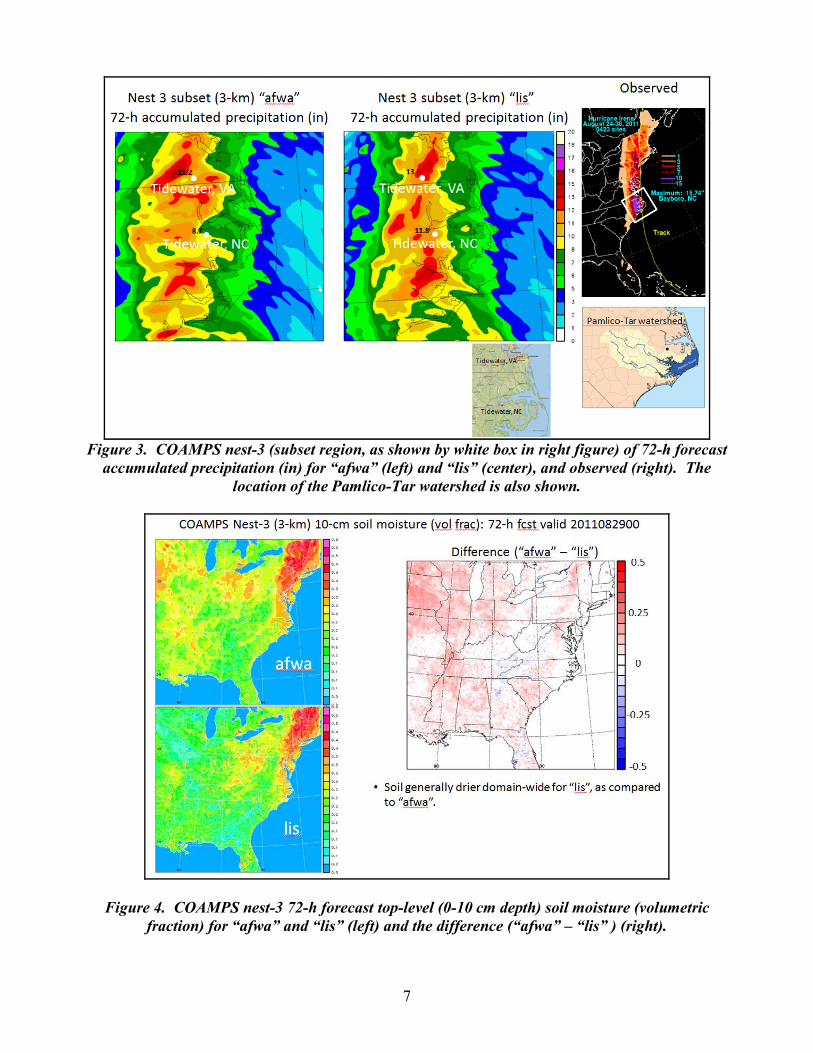
These COAMPS model output data sets have been provided to both NASA for further analysis in their Land Verification Toolkit (LVT) software package, and well as to NCAR to examine impacts on WRF-Hydro linkage. In coordination with the LVT validation effort, extensive datasets necessary for land surface validation (e.g., Ameriflux and SURFRAD fluxes, NOAA Climate Prediction Center (CPC) precipitation, AMSR-E soil moisture retrievals, etc.) have been archived for the Irene and Lee cases. RESULTS The setup for the two COAMPS simulations of Hurricane Irene is shown in Figure 2. The two simulations both are cold start 72-h forecasts initialized at 00 UTC 26 August 2011, with three nests (27-, 9-, and 3-km horizontal resolution), using the NOAH LSM v3.4. The only difference between the two simulations is the initialization of the soil state. Experiment “afwa” uses the global 25-km soil fields (soil moisture and temperature) obtained from the Air Force Weather Agency (AFWA), interpolated to the COAMPS grids. The surface parameters (e.g., soil and vegetation types, terrain, etc.) are from the standard COAMPS initialization based on the US Geological Survey (USGS) database. Experiment “lis” uses the soil fields from NASA LIS spun up on the native COAMPS grids, with surface parameters from the NASA Land Data Toolkit (LDT) input file based on the modified International Geosphere Biosphere Programme (IGBP) Moderate Resolution Imaging Spectroradiometer (MODIS) database. Qualitative and quantitative validation using the standard NRL verify software package against radiosonde and surface (land, ship, and buoy) observations were both performed. Figure 3 shows 72-h forecast accumulated precipitation for a zoomed-in portion of COAMPS nest-3 centered over the Pamlico-Tar watershed in eastern NC. This watershed is a focal point for the hydrological portion of the Irene case study and will be investigated in more detail in future coupled COAMPS/WRF-Hydro simulations. Results for the two COAMPS simulations show qualitatively similar results, with large regions of precipitation (> 10 inches) extending from the region near Tidewater, VA south to Cape Fear, NC. Model predicted values show reasonable agreement with observed values at Tidewater, VA (6.52 inches) and Tidewater, NC (11.27 inches). Figure 4 shows the COAMPS nest-3 72-h forecast top-level (0-10 cm depth) soil moisture (volumetric fraction) for the two simulations, and their difference. The top-level soil mositure is generally drier domain-wide for “lis” as compared to “afwa”. This is consistent throughout the simulation period as well (as “lis” is initialized generally drier than “afwa”, not shown). A time series comparison of Soil Climate Analysis Network (SCAN) and Natural Resources Conservation Service (NRCS) National Water and Climate Center soil moisture data at the observation site at Tidewater, VA to COAMPS forecasts is shown in Figure 5. Although experiment “lis” is initialized drier (as discussed above), the time period of heavy precipitation (~33-36 h) is similar for both experiments, resulting in soil wetting, sufficient to saturate the local soil and yield similar soil moisture results from ~36 to 72 h. Single point validation can often be problematic, so more extensive validation of soil state parameters is underway, using the new NASA LVT package. Project collaborators at NASA are currently developing software to allow for COAMPS ingest into LVT for direct validation with their available datasets. Results from the quantitative validation for near-surface observations is shown in Figure 6. As seen in the comparsion of soil moisture above, the “lis” experiment is generally drier in the atmosphere as well, as compared to “afwa”. Experiment “lis” is also generally warmer near the surface than “afwa”. Statistics for other variables (sea level pressure and winds) are similar for both experiments. These statistics are for only one 72-h forecast and futher experiments and validation is ongoing.

5
IMPACT/APPLICATIONS This new high-resolution coupled hydrological modeling capability within COAMPS will have a tremendous impact of the near-shore coupled modeling and simulation capability available for Naval operations. A basic weakness of many LSMs is that runoff and stream flow typically does not recycle back into the water cycle, but is simply treated as a sink in the system. Thus, a key feedback mechanism is not properly accounted for in the budget. With this new development and its potential for future linkage with near-shore ocean models, a more accurate representation of near-shore processes will be available. In addition, with the development of an improved hydrological modeling capability within COAMPS, the importance of accurate quantitative precipitation forecasting (QPF), particularly at high-resolution will be magnified. A new generalized two-moment ensemble-based microphysics scheme has recently been developed for use in COAMPS. The scheme is expressed in terms of a few coefficients which govern all mass-diameter, velocity-diameter, and particle size distributions relationships so that uncertainty in the model microphysics can be readily incorporated within an ensemble framework. The scheme allows the user to specify the moments of the particle size distribution at run time and uses highly accurate numerical-based lookup tables to compute all interspecies collections terms. This allows one to incorporate diameter-dependent collection efficiencies and numerical bounding techniques that reduce the temporal truncation error associated with the usage of larger time-steps across various model nests. The goal is to provide a linkage between this new microphysics scheme and the new terrestrial hydrology model to improve forecast capability through improved atmospheric-LS hydrological feedback. RELATED PROJECTS This project is related to 6.2 projects within PE 0602435N that focus on the development of the atmospheric and air/ocean coupled components (QC, analysis, initialization, and forecast model) of COAMPS. Developments in model post-processing software concerning the diagnosis and analysis of fields relevant to coupled prediction generated for this work would be transtioned via the SPAWAR-funded “Small-scale atmospheric models (COAMPS)” and “COAMPS-On Scene” projects.

6
Figure 1. Total storm precipitation for the two cases studies considered in this project, Irene (left) and Lee (right).
Figure 2. COAMPS model configuration for Hurricane Irene case study.
7
Figure 3. COAMPS nest-3 (subset region, as shown by white box in right figure) of 72-h forecast
accumulated precipitation (in) for “afwa” (left) and “lis” (center), and observed (right). The location of the Pamlico-Tar watershed is also shown.
Figure 4. COAMPS nest-3 72-h forecast top-level (0-10 cm depth) soil moisture (volumetric fraction) for “afwa” and “lis” (left) and the difference (“afwa” – “lis” ) (right).

8
Figure 5. A time series comparison of Soil Climate Analysis Network (SCAN) and Natural Resources Conservation Service (NRCS) National Water and Climate Center soil moisture data at
the observation site at Tidewater, VA to COAMPS forecasts. The top panel shows observed soil moisture for five depths (magenta: 5 cm; yellow: 10 cm; green: 20 cm; blue: 100 cm; red: 200 cm ),
and observed precipitation (aqua).
Figure 6. COAMPS nest-3 -72h forecast near-surface statistics verified against land, ship, and buoy
data for a) 2-m air temperature, b) sea level pressure, c) 10-m wind speed, d) 2-m dew point temperature, e) 2-m relative humidity, and f) 10-m wind direction for experiments “afwa” (blue) and
“lis” (red) for RMSE (solid line) and bias (dashed line).