1616049 willis creek ems - final report
TRANSCRIPT

q u a l i t y s o l u t i o n s s u s t a i n a b l e f u t u r e
Estuary Management S tudy
Willis Creek

This page has been left intentionally blank

Estuary Management S tudy
Willis Creek
Prepared for: Coffs Harbour City Council and NSW Office of Environment and Heritage
© GeoLINK, 2011
PO Box 119 Lennox Head NSW 2478
T 02 6687 7666
PO Box 1446 Coffs Harbour NSW 2450
T 02 6651 7666

Version History UPR Description Date Issued Issued By Reviewed By 1616877 Initial Draft 7/10/2011 Tim Ruge Cate Walsh 1616511 Final Draft 24/11/2011 Tim Ruge Kim Casson 1616049 Final 15/12/2011 Tim Ruge Kim Casson

Table of Contents
Willis Creek Estuary Management Study 1616049
i
1 Introduction 3
1.1 Background ............................................................................................................................................ 3
1.2 Report Structure ..................................................................................................................................... 5
1.3 Planning Framework ............................................................................................................................... 5
2 Estuary Processes 7
2.1 Hydrodynamics ....................................................................................................................................... 7
2.1.1 Hydrodynamic States and Entrance Behaviour .................................................................................. 7
2.1.2 Coastal Processes and Inundation ..................................................................................................... 7
2.2 Geomorphology and Sediment Dynamics .............................................................................................. 9
2.2.1 Bank Erosion ...................................................................................................................................... 9
2.3 Water Quality Processes ...................................................................................................................... 10
2.4 Ecological Processes ........................................................................................................................... 10
2.4.1 Estuarine Habitat .............................................................................................................................. 10
2.4.2 Aquatic Fauna .................................................................................................................................. 12
2.4.3 Little Terns ....................................................................................................................................... 12
2.4.4 Riparian Vegetation .......................................................................................................................... 12
2.4.5 Estuary Health .................................................................................................................................. 12
2.5 Climate Change and Sea Level Rise .................................................................................................... 15
2.5.1 Climate Change and Sea Level Rise Impacts on Estuary Processes .............................................. 15
3 Community Consultation 17
3.1 Initial Community Workshop ................................................................................................................. 17
3.2 Community Survey ............................................................................................................................... 17
4 Values 19
5 Objectives and Management Issues 21
5.1.1 Entrance Conditions and Hydrodynamics Objectives ....................................................................... 21
5.1.2 Bank Stability and Sedimentation Objectives ................................................................................... 21
5.1.3 Ecological, Habitat and Biodiversity Objectives ............................................................................... 21
5.1.4 Water Quality Objectives .................................................................................................................. 22
5.1.5 Recreational Use and Access Objectives ........................................................................................ 22
5.1.6 Views and Visual Character ............................................................................................................. 23
5.2.1 Entrance Conditions and Hydrodynamics Issues ............................................................................. 23
Willis Creek Estuary Management Study 1616049
ii
5.2.2 Bank Stability and Sedimentation Issues ......................................................................................... 23
5.2.3 Ecological, Habitat and Biodiversity Issues ...................................................................................... 23
5.2.4 Water Quality Issues ........................................................................................................................ 24
5.2.5 Recreational Use and Access Issues ............................................................................................... 26
5.2.6 Views and Visual Character Issues .................................................................................................. 26
5.3 Ranked List of Issues ........................................................................................................................... 26
6 Management Strategies 29
Illustrations Illustration 1.1 Study Area ................................................................................................................................ 4
Tables Table 5.1 Ranked List of Key Estuary Management Issues ............................................................................ 28
Table 6.1 Potential Estuary Management Strategies for Willis Creek Coastal Zone Management Plan ......... 30
Plates Plate 1.1 Aerial Image of Willis Creek Estuary ................................................................................................. 3
Plate 2.2 Coastal Inundation Mapping for the Year 2050 ................................................................................. 9
Plate 2.3 Bank Erosion Severity (mapped January 2011) .............................................................................. 10
Plate 2.4 Riparian Vegetation Condition (mapped January 2011) .................................................................. 11
Plate 2.5 Riparian Vegetation Condition (mapped January 2011) .................................................................. 13
Plate 2.6 Distribution of Priority B and Priority C Invasive Weed Species (mapped January 2011) ............... 14
Plate 5.1 Future Industrial and Residential Growth Areas .............................................................................. 25
Appendices A Community Survey Data
B Planning Framework

Executive Summary
Willis Creek Estuary Management Study 1616049
1
This Estuary Management Study has developed a range of potential management strategies for the Coastal Zone Management Plan (CZMP) for Willis Creek estuary. Willis Creek is an Intermittently Closed and Open Lakes and Lagoon (ICOLL). The density of vegetation and lack of public access to the Willis Creek estuary generates little recreational activity. However, the natural setting attracts people seeking quiet recreational opportunities such as bird watching and bushwalking. Willis Creek has a large area of swamp forest, wet heath and mangrove / saltmarsh complex which is largely contained in the Coffs Coast Regional Park. The Willis Creek / Hearns Lake entrance area hosts a significant breeding site in NSW for the threatened species, Little Tern (South-eastern Australian population). Banana plantations and blueberry farms cover the majority of the upper catchment of Willis Creek. Industrial and residential land comprises the majority of the mid-catchment on the eastern side of the Pacific Highway. The site of the Woolgoolga Water Reclamation Plant covers a significant proportion of the lower estuary catchment. The plant released treated effluent into Willis Creek from 1973 to 2005. The release ceased in 2005 with the plant upgrade and connection to the Coffs Harbour recycled water system. Some of the key estuary management issues that have been identified relate to: management of sediment, nutrient and other pollutant inputs from the catchment; increased urbanisation of the catchment with expansion of industrial and residential areas; protecting the native riparian vegetation from threats such as environmental weeds; water quality issues such as elevated turbidity levels, total nitrogen and chlorophyll-a; increased recreational activity and uncontrolled access to riparian areas has the potential to damage the
natural environment; and climate change impacts (particularly sea level rise and consequent lake water level increases) on the
estuarine ecology and water quality. A range of potential management strategies addressing the issues have been developed and prioritised for initial consideration by the community and stakeholders prior to further development. Further development following consultation will involve re-prioritising where necessary, detailing of actions required for implementation, estimated costs, responsibilities, funding sources, etc. These details will be included in the final Coastal Zone Management Plan for the Willis Creek estuary. Key strategies relate to the following: educational strategies: soil and erosion management and wastewater management for agricultural practices; stormwater management measures; weed management; improvements to the existing vehicular access route to enable easier access and minimise disturbance of
adjoining vegetation; investigate the provision of a viewing platform with seating at the most elevated point adjacent to the beach
carpark to optimise the available views across the creek and beach; assessing available corridors for migration of mangrove and saltmarsh colonies in response to sea level rise; a water quality monitoring program for Willis Creek; supporting existing management actions for the Little Tern breeding site at the Hearns Lake / Willis Creek
entrance; and developing a formal Entrance Management Policy with the aim to minimise interference with the natural
opening and closing processes of the creek entrance.

This page has been left intentionally blank

1
Willis Creek Estuary Management Study 1616049
3
Introduction 1 1 1
This study develops the framework for the preparation of a Coastal Zone Management Plan’s (CZMP) for Willis Creek estuary. This study identifies: the pressures impacting on the health of the estuary; and management options to address these pressures. The area addressed by this Estuary Management Study is shown in Illustration 1.1. The study area comprises the waterway, foreshores and land adjacent to the estuary up to the tidal limit and the drainage catchment contributing to the estuary. The study also considers issues associated with the wider catchment upstream of the tidal limit.
Source: Google Earth, 2011
Plate 1.1 Aerial Image of Willis Creek Estuary
1.1 Background In 2004, the Coffs Harbour City Council (CHCC) Coastal Estuary Management Advisory Committee (CEMAC) adopted the goal “to assist council in achieving an integrated, balanced, responsible and ecologically sustainable use of the Woolgoolga Lake Estuary.”

WOOLGOOLGA
Beac
hBa
ck
Woo
lgoo
lga
Woolgoolga WaterReclamation Plant
Willis Creek
Paci
fic H
ighw
ay
Willis Creek Estuary Management Study1616120
Illustration
Study Area
Nor
th
1.1
Drawn by: RE Checked by: TIM Reviewed by: TIM Date: August 2011Source of base data: Coffs Harbour City CouncilInformation shown is for illustrative purposes only
0 200

Willis Creek Estuary Management Study 1616049
5
In 2010, CHCC and Office of Environment and Heritage (OEH) engaged GeoLINK in association with Aquatic Science and Management and GECO Environmental to develop a CZMP for Willis Creek estuary. The engagement includes the preliminary phases of data compilation and preparing an Estuary Processes Study and Estuary Management Study. The Data Compilation and Estuary Processes Study was completed in July 2011. This provides an understanding of the relationship between the estuary processes, external influences and issues of concern which are summarised in Section 3 of this report. This Estuary Management Study has been prepared in consideration of the OEH Guidelines for Preparing Coastal Zone Management Plans (DECCW, 2010). It is noted that the CZMP will only address coastal risks insofar as how they affect estuarine processes. Coffs Harbour City Council is developing a Coastal Zone Management Plan under a separate study to directly address coastal risks in the Coffs Harbour Local Government Area. For the purpose of avoiding confusion between the CZMP’s, the body of this report will refer to the CZMP for Willis Creek estuary as an “Estuary Management Plan” or “EMP”.
1.2 Report Structure This report is structured in the following manner: Section 1 Introduction
Describes the study area and outlines the statutory framework for estuary management in NSW including the various legislative, policy, and planning instruments that apply to the Willis Creek Estuary Management Plan
Section 2 Estuary Processes Presents an overview and the outcomes of the Estuary Processes Study.
Section 3 Community Consultation and Stakeholder Liaison Presents a summary of the outcomes of community and stakeholder consultations.
Section 4 Estuary Values Presents an overview of estuary values, uses of the estuary, and issues derived from the consultation and literature review.
Sections 5 Objectives and Management Issues This section outlines the vision, objectives and issues for the Willis Creek estuary including an overview of the current status of the topic, and associated management issues, objectives and proposed management strategies. The issue topics comprise: entrance conditions and hydrodynamics, bank stability and sedimentation objectives, ecological, habitat and biodiversity, water quality, recreational use and access and catchment management.
Section 6 Summary of Management Strategies Presents a summary and prioritisation of the proposed management strategies from the previous sections
1.3 Planning Framework The planning framework (planning instruments, policies and management plans) relevant to the proposed estuary management strategies will be detailed for each strategy / action as part of the Estuary Management Plans. An overview of the planning framework is provided in Appendix B.

This page has been left intentionally blank

2
Willis Creek Estuary Management Study 1616049
7
Estuary Processes 2 2 2
Willis Creek is an Intermittently Closed and Open Lakes and Lagoon (ICOLL). The density of vegetation and lack of public access to the Willis Creek estuary generates little recreational activity. However, the natural setting attracts people seeking quiet recreational opportunities such as bird watching and bushwalking. The Willis Creek / Hearns Lake entrance area hosts a significant breeding site in NSW for the threatened species, Little Tern (South-eastern Australian population). The total catchment area of Willis Creek is approximately 2.6 km². Banana plantations and blueberry farms cover the majority of the upper catchment. Industrial and residential land comprises the majority of the mid-catchment on the eastern side of the Pacific Highway. The catchment area downstream of the tidal limit includes the Woolgoolga Water Reclamation Plant (sewage treatment plant) and a large area of swamp forest, wet heath and mangrove / saltmarsh complex which is largely contained in the Coffs Coast Regional Park. The tidal limit of Willis Creek is located near the eastern edge of the residential and industrial estates in the mid-catchment. The creek is part of the Solitary Islands Marine Park and is zoned as a Habitat Protection Zone up to the tidal limit. The Woolgoolga Water Reclamation Plant released secondary treated effluent into Willis Creek from 1973 to 2005. The release ceased in 2005 with the upgrade of the plant and connection to the Coffs Harbour reclaimed water reticulation system. The key findings and recommendations of the Data Compilation and Estuary Processes Study – Darkum Creek, Woolgoolga Lake and Willis Creek (GeoLINK et al., 2011) is summarised below for Willis Creek.
2.1 Hydrodynamics 2.1.1 Hydrodynamic States and Entrance Behaviour
Theory suggests that the predominant hydrodynamic state of Willis Creek is a closed entrance. However, over the period of 1973 to 2005 when the creek received a continued release of treated effluent from the Woolgoolga Water Reclamation Plant the entrance was generally open, discharging low flows across the beach. Aerial photography indicates the following in regard to entrance openings: 1940s and 1950s: the entrance channel was closed in the 1940s photography. In 1956 the entrance
channel meandered to the south-east to discharge on the north side of the tombolo; 1960s and 1970s: six photos for the 1960s indicate the entrance channel was closed. Four photos for the
1970s indicate the entrance was open on three occasions and closed on the other; 1980s: the entrance channel was open on all photographs during the 1980s; 1990s: the entrance channel was open on all photographs (1994 and 1996); and 2000’s: the entrance was closed in two photos (2000 and 2009) and open in three photographs (2001, 2006
and 2010). 2.1.2 Coastal Processes and Inundation
Coastal processes influence estuary hydrodynamics, sedimentation processes and entrance behaviour. Water levels in Willis Creek are relatively constant. Conductivity levels indicate the estuary is subject to regular seawater ingress through overtopping of the entrance berm during higher stages of the tide. The likely extent of beach erosion for the immediate timeframe is an ‘almost certain’ probability of 15 m, ‘unlikely’ probability of 50 m

Willis Creek Estuary Management Study 1616049
8
and ‘rare’ probability of 85 m landward movement of the beach position (BMT WBM, 2010b). For the 2050 and 2100 timeframes, the ‘almost certain’, ‘unlikely’ and ‘rare’ erosion extents are added to the long term shoreline recession values described above.
Source: BMT WBM (2010b)
Plate 2.1 Beach Erosion and Shoreline Recession Mapping for the Year 2050
In the immediate timeframe, there is potential inundation of back beach areas at Willis Creek, with the ‘almost certain’ to ‘rare’ probability water levels covering a similar extent, generally over the footprint of Willis Creek. By 2100 with sea level rise, the ‘unlikely’ and ‘rare’ inundation extents expand in area around the creek footprint, but do not appear to threaten development (BMT WBM, 2010b:141). Refer to Plate 2.1.

Willis Creek Estuary Management Study 1616049
9
Source: BMT WBM (2010b)
Plate 2.2 Coastal Inundation Mapping for the Year 2050
Predicted sea level rise and shoreline recession indicates that the Willis Creek entrance is likely to migrate north to a similar position where the creek currently turns southward.
2.2 Geomorphology and Sediment Dynamics 2.2.1 Bank Erosion
Bank erosion is not a significant issue in the Willis Creek estuary with only 11% of estuary banks subject to minor erosion and no moderate or severe erosion reaches identified – refer to Plate 2.3. The stable banks were naturally stable without the use of erosion protection works or bedrock outcropping.

Willis Creek Estuary Management Study 1616049
10
Source: GeoLINK et al. (2011)
Plate 2.3 Bank Erosion Severity (mapped January 2011)
2.3 Water Quality Processes No recorded physico-chemical water quality data has been found for the period of 2005 to 2010 since cessation of effluent release in 2005. Faecal indicator organism samples indicate the waters of Willis Creek (for the period sampled) are generally safe for primary contact recreation. Chlorophyll-a concentrations indicate that Willis Creek was eutrophic during the period of effluent discharge. Nutrient and sediment modelling of the estuary catchment indicates horticulture and residential land are the main contributors of catchment derived sediments and nutrients for Willis Creek.
2.4 Ecological Processes 2.4.1 Estuarine Habitat
Benthic habitat was a mixture of sand, mud and gravel bars in the estuary. The extent of mangroves has increased in the estuary. In the opinion of the author/s this is probably a result of a reduction in freshwater inflow since the cessation of effluent discharge. Using the difference between the volume of effluent received at the plant and the volume of effluent recycled the average discharge over the years between 2002/03 and 2004/05 was in the order of 449 ML per annum (S Thorn 2011 pers comm). The removal of this freshwater influence is thought to have improved the conditions for grey mangrove recruitment through changes to the salinity regime. Willis Creek has a large area of saltmarsh habitat – refer to Plate 2.4. The area of saltmarsh recently mapped (2010) appeared almost four times less than shown by previous mapping (2004), however there are clear differences in the methods used between the two studies leading to an inconclusive trend.

Willis Creek Estuary Management Study 1616049
11
Source: GeoLINK et al. (2011)
Plate 2.4 Riparian Vegetation Condition (mapped January 2011)

Willis Creek Estuary Management Study 1616049
12
2.4.2 Aquatic Fauna
Macroinvertebrate fauna were sampled and analysed: the results indicate that the central regions of the waterway contain the most diverse and abundant benthic macroinvertebrate fauna. A survey of fish species was undertaken with relatively few animals from a small number of taxa collected. No threatened aquatic species have been reported for Willis Creek. 2.4.3 Little Terns
A significant NSW breeding site for the Little Tern is located at the Willis Creek / Hearns Lake entrance area. A Shorebird Recovery Program has been devised to guide management of the site including fencing off of the nesting site, community awareness initiatives, a fox abatement plan and monitoring. The management works will provide an umbrella effect for local biodiversity, including other locally breeding migratory and shorebirds species. 2.4.4 Riparian Vegetation
Riparian vegetation in the study area is predominately in moderate to very good condition (refer to Plate 2.5). 17% of banks had riparian vegetation in moderate condition and these reaches were confined to the banks nearest to the entrance. The distributions of major weeds along the estuary have been mapped (refer to Plate 2.6). Four of the mapped invasive weed species are listed as Priority B or C in coastal or riparian landscapes under the Northern Rivers Invasive Weed Strategy 2009-2013. 2.4.5 Estuary Health
There is too little information to make an informed assessment of the health of Willis Creek: there is a lack of recent water quality data. Sediment quality data would also be useful as excess nutrients
are likely to have been stored in the benthic sediment. Previous water quality data indicated that Willis Creek suffered from excessively high nutrient concentrations;
saltmarsh and mangrove habitats are in relatively good condition. The riparian corridor is negatively impacted by weeds but well protected against erosion and well vegetated;
fish and macroinvertebrate populations are scarce and lack diversity, though macroinvertebrate diversity appears to be improving; and
blue green algae occurs in frequent small patches. There are no reported fish kills.

Willis Creek Estuary Management Study 1616049
13
Source: GeoLINK et al. (2011)
Plate 2.5 Riparian Vegetation Condition (mapped January 2011)

Willis Creek Estuary Management Study 1616049
14
Source: GeoLINK et al. (2011)
Plate 2.6 Distribution of Priority B and Priority C Invasive Weed Species (mapped January 2011)
Willis Creek Estuary Management Study 1616049
15
2.5 Climate Change and Sea Level Rise Climate change is projected to include an increased frequency of hot days, increased intensity and frequency of extreme daily rainfall events and droughts, changes to sea levels and changes in the occurrence of intense storm events. Climate change projections at the local scale for the Coffs Harbour area are described in a report by BMT WBM (2010a). The climate change projections for the Coffs Harbour area (relative to the 1977 to 2007 period) include the following: evaporation: decreases in summer and spring and increases in autumn and winter; temperature: decreases in average temperatures for summer, autumn and spring and increases in winter; Extreme Hot Days: significant increases in the annual number of extreme hot days; Average Rainfall: increases in annual totals and seasonal totals except for decreases in autumn totals for
the Coffs Harbour area; High Rainfall Events: increases in frequency of high rainfall events in summer and autumn; Sea Level Rise: 0.4 m increase in mean sea level by 2050 and 0.9 m increase by 2100 (relative to 1990
mean sea levels); and Wave Climate: future wave climate will be similar to the present or within the variability of the existing wave
climate. However, the Coffs Harbour Coastal Processes and Hazards Definition Study (BMT WBM, 2010b) investigated the possibility of a permanent shift from the existing south easterly wave climate to a more easterly wave climate with average wave height remaining the same.
2.5.1 Climate Change and Sea Level Rise Impacts on Estuary Processes
General estuary processes that will be impacted by climate change include (after Haines, 2006 and 2008; Mackenzie et al., 2009): coastal processes and interactions with estuary entrances: e.g. a landward and upward shift in entrance
channels in response to sea level rise; hydrodynamics: changes in water level and altered tidal prisms due to changes to entrance conditions;
impacts of altered rainfall and evaporation patterns. Predicted sea level rise may result in higher water levels within the estuary and potentially an increase in typical water depths;
sediment dynamics: changes to ingress of marine sediment due to changes to entrance conditions and changes to sediment derived from catchment runoff in response to an increase in high rainfall events;
water quality: changes to water temperature and sediment dynamics and subsequent changes to chemical and physical processes in the estuary; and
ecology: the impacts of increased water levels and altered hydrodynamics, sediment dynamics and water quality on ecological processes.

This page has been left intentionally blank
3
Willis Creek Estuary Management Study 1616049
17
Community Consultation 3 3 3
Community consultation aims to discover community aspirations and gain stakeholder input to the Project to ensure that the Estuary Management Plan is accepted by the community as a coherent, practical and achievable plan.
3.1 Initial Community Workshop A Community Workshop was held at Woolgoolga Community Centre on 14 September 2010. The purpose of the initial Community Workshop was to gain input on Community values, issues and objectives for the three estuaries. Approximately 30 people attended the workshop. Council and the consultant team (GeoLINK / GECO Environmental / Aquatic Science and Management) provided an introduction on the Estuary Management Plan process. The attendees then formed five groups to discuss and compile a list of key issues and goals for the estuaries. Following the group work a representative from each group summarised their key issues and goals. A final question time was undertaken before the workshop concluded. The key focus of the attendees was generally Woolgoolga Lake and no specific comments were provided in regard to Willis Creek. However, some of the general comments applicable to the three estuaries are provided below in regard to goals and issues developed during group work.
Goals: improved water quality; foreshore management; water quality monitoring; and improved fish breeding.
Issues: Address water quality issues associated with runoff from rural lands and urban areas (nutrients, herbicides,
pesticides, sediment and organic matter).
3.2 Community Survey A Community survey was undertaken over a two month period from April to May 2011, encompassing a school holiday period to provide opportunity to capture input from the widest possible catchment of users. The surveys were located at Council offices, local outlets in the estuary catchments such caravan parks, newsagents and post offices. In addition, a web survey was made available through the website. The survey data is tabulated in Appendix A and summarised below. The total number of completed surveys received was 50. Note that Questions 6 and 8 apply to the Woolgoolga Lake Estuary and have therefore not been included.

Willis Creek Estuary Management Study 1616049
18
1. Where are respondents from? Sixty percent of respondents were from the Woolgoolga area, 22 % from Safety Beach and 16 % from elsewhere in the Coffs Harbour Council area. One respondent was from outside the Coffs Harbour Council area at the time of completing the survey. 2. How often do you visit or use Willis Creek? Eighty-four percent of respondents indicated they visit Willis Creek. 44% rarely or never visit, and 26% visit Willis Creek a few times a year. 4% of total respondents visit Willis Creek daily. 3. Indicate how you use the estuary: Survey results indicate the main use of the Willis Creek estuary is walking, with 36% of total respondents identifying this use. Bird-watching and dog walking were the next most significant uses, identified by 14 and 10% of respondents respectively. Swimming and boating were not identified by any respondents as uses of the Willis Creek estuary. Other uses of Willis Creek identified by respondents included volunteering for the Little Tern Colony, and bait collecting. 4. Indicate your level of concern for the following estuary-related issues: The estuary issues of most concern that apply to Willis Creek estuary, identified by 66% of respondents was water quality issues associated with runoff from agricultural lands and urban areas. The estuary issues of least concern that apply to Willis Creek, identified by 38% of respondents was insufficient walking tracks around Willis Creek. 5. Indicate the importance you place on the following estuary related goals: The estuary goals of most importance, identified by 76-82% of respondents were: improved water quality; improved aquatic habitat within the lake and creeks to support fish stocks, crustaceans, etc; and improved runoff control in urban areas of the catchment. The estuary goals of least importance that apply to Willis Creek, identified by 22% of respondents was improved walking tracks around Willis Creek estuary. 7. Use of motor boats in the estuary: Seventy-six percent of respondents indicated they do not support the use of motor boats, and 22% of respondents indicated they do support the use of motor boats in the Darkum Creek, Woolgoolga Lake and Willis Creek estuaries. 9. Other comments A summary of other comments supplied is provided in Appendix A.

4
Willis Creek Estuary Management Study 1616049
19
Values 4 4 4
4.1 Local and Regional The natural settings of the estuaries and coast within the Mid North Coast area are a feature that attracts visitors and locals to the area. Willis Creek is in keeping with this natural setting, and forms part of the network of bushland settings along the coast and estuaries and is of local and broader significance. Key values of the estuary include its natural setting, Little Tern breeding site and quiet recreational opportunities including bird watching and bushwalking.
4.2 Cultural Heritage Aboriginal, European and Sikh cultural heritage values are significant for the Woolgoolga area. The Woolgoolga area was (and continues to be) inhabited by the Gumbayngirr people prior to European Settlement. Records show that an artefact find is located within the study area, and two Aboriginal ceremonial and dreaming sites are located within close proximity of the Willis Creek catchment. The cultural values of these Aboriginal sites within the Willis Creek catchment area require sensitive consideration and preservation. Europeans moved into the Woolgoolga area from the 1870s. Records indicate that there are no listed European cultural items of significance within the study area. Land use within the Willis Creek estuary catchment changed from predominantly native vegetation in 1943, to clearing of land on the southern and western side of the creek between 1964 and 1974, and the significant growth of residential and industrial development (including the STP site) between 1974 and 1994 between the creek and the existing Pacific Highway. The Coffs Harbour Coastal Processes and Hazards Definition Study Draft Report, prepared by WBM, indicates that sand mining leases existed and sand mining may have occurred at Woolgoolga Back Beach and Hearns Lake Beach (Willis Creek estuary catchment area).
4.3 Recreational Values Willis Creek is a relatively small and remote coastal estuary with dense vegetation and a lack of public access. However it offers the following recreational values: water-based activity including kayaking and canoeing in the creek; and the natural setting attracts people seeking quiet recreational opportunities such as bird watching and
bushwalking. Odours from the STP site may deter visitors at certain times such as early mornings when odours are relatively strong around the STP site.
4.4 Scenic Values Willis Creek offers a predominantly undisturbed natural environment that forms an integral and important component of the natural settings along the coastline. Willis Creek is a remote, densely vegetated estuary and

Willis Creek Estuary Management Study 1616049
20
with limited access which combine to significantly restrict visual access into the area. It offers the following scenic values: limited, short distant views into the foreshore vegetation from the vehicle access track; highly scenic, panoramic views across upstream and downstream reaches of the creek from an elevated
vantage point at the top of the dune near the carpark at the end of the track; the mouth of the creek to the south of the car park also offers an uninterrupted view of the downstream
reach of the creek and its partial opening to the ocean; and much of the Willis Creek reserve has been retained in its natural state and the creek follows a narrow
channel that meanders through dense, visually rich riparian vegetation which encloses and protects the creek to produce a highly tranquil and scenic environment.
4.5 Water Quality Values It is difficult to describe the current water quality values of Willis Creek as very little water quality data has been collected since 2005. When water quality data were last collected the creek received treated effluent from the Woolgoolga Wastewater Treatment Plant (WWTP). In 2005 CHCC upgraded the WWTP and diverted treated effluent elsewhere. It is likely that the intervening years have resulted in an improvement in water quality. By most measures available, the water quality of Willis Creek was poor during the effluent release period. However, surprisingly, the water quality data during this period indicates that according to the old ANZECC (2000) guidelines for recreational use, Willis Creek would have been suitable for primary contact recreation. Physico-chemical water quality information (salinity, pH, dissolved oxygen (DO), turbidity and temperature) was collected on 8 February 2011 as part of this study from three sites in Willis Creek to assess long channel and vertical variation in water quality. The creek was open to the ocean at the time of sampling, though it did not appear to be receiving tidal water, only draining to the ocean. Willis Creek was sampled at the beginning of the incoming tide. The results indicated the creek is well mixed for most of the estuary length, with a gentle reduction in salinity moving upstream, accompanied by a fall in pH and DO. The water quality of Willis Creek was a relatively even mixture of seawater and freshwater.
4.6 Ecological Values Ecological characteristics of Willis Creek that can be considered values include: a relatively large area of saltmarsh habitat. Saltmarsh contributes to the overall productivity of the estuary
and provides habitat for fish and invertebrates. Saltmarsh is also protected as an endangered ecological community (EEC) under the TSC Act;
an area close to the entrance to Willis Creek is used as a breeding site for a population of the endangered little tern (Sterna albifrons);
the riparian vegetation of Willis Creek is mostly intact and in good (73%) to very good (9%) condition. Riparian vegetation filters overland flows, stabilises banks, provides structural habitat for fish and contributes to the overall productivity of the estuary;
approximately 0.9 ha of mangrove habitat showing active recruitment. Mangroves are an important primary producer driving the overall productivity of the system, process pollutants in the water, provide structural habitat for fish and invertebrates and stabilise banks and sediment;
reeds and rushes are common along the margins of the central channel and upper creek, contributing to productivity, habitat value and bank stability; and
a quiet, natural environment where low impact activities, such as bird watching and walking, can be appreciated.

5
Willis Creek Estuary Management Study 1616049
21
Objectives and Management Issues 5 5 5
5.1 Objectives 5.1.1 Entrance Conditions and Hydrodynamics Objectives
5.1.1.1 Promote Natural Entrance Opening / Closing Processes Willis Creek is an ICOLL system that is predominantly closed. The entrance opens and closes to the ocean naturally in a constant but irregular cycle depending on fluvial, tidal and wave processes. Artificial opening of ICOLL’s can have significant negative impacts on water quality, fish and other ecological communities. Council does not have any current opening protocol for Willis Creek entrance. However, it is noted that during the period of release of effluent into Willis Creek from the Woolgoolga Water Reclamation Plant (1973 to 2005), the plant operator checked the entrance on a daily basis to ensure that it did not fully close (Jelliffe, 1997a). There are no records of artificial opening of the entrance since the cessation of effluent release in 2005. Community consultation has not indicated any desire for artificial opening of the creek entrance. Nor is there currently any significant need for artificial opening for the purpose of flood mitigation. Nevertheless, a formal entrance management policy will be developed for Willis Creek in accordance with OEH Guidelines for Preparing Coastal Zone Management Plans (DECCW, 2010) which requires EMPs for ICOLLS to include such a policy. The objective of the entrance management policy will be to maintain a natural opening / closing regime for the creek entrance. Interference (artificial opening of the entrance) would only be employed for critical situations such as to mitigate and reduce the impacts of flooding on properties and infrastructure adjoining the creek. 5.1.1.2 Avoid Flooding of Properties and Infrastructure Flood level estimates for Willis Creek and inundation mapping associated with elevated ocean levels indicates there are no properties or infrastructure currently at risk of significant flooding. However sea level rise will result in higher inundation levels within the creek system in the future. Therefore the objective is to minimise or avoid future flooding of properties and infrastructure around the creek by appropriate means such as development controls for future development in flood prone areas; artificial opening of the creek entrance where appropriate; flood-proofing infrastructure; etc. These strategies are addressed in Section 6. 5.1.2 Bank Stability and Sedimentation Objectives
Bank erosion and estuary sedimentation are not significant issues in the Willis Creek estuary (Geolink et al., 2011), although 11% of banks surveyed were recorded with minor erosion, all such banks occurred in the lower reaches of the estuary where the channel runs between the beach dunes and the back barrier dune. As the banks are essentially composed of sands with little cohesion they are highly susceptibility to wash and, when the entrance is open, tidal flow. Intervention is this setting is not required and consequently there are no recommended objectives for addressing bank stability or sedimentation in the Willis Creek estuary. 5.1.3 Ecological, Habitat and Biodiversity Objectives
5.1.3.1 Protect Saltmarsh and Mangrove Habitats From Disturbance The Northern Rivers Catchment Management Authority (NRCMA) Catchment Action Plan (CAP) lists rehabilitation of aquatic habitats among its goals. Willis Creek has abundant mangrove habitat and a locally significant area of saltmarsh habitat.

Willis Creek Estuary Management Study 1616049
22
Mangrove and saltmarsh habitats in Willis Creek are mostly in good condition. An objective of the Willis Creek Estuary Management Plan is to protect these communities from disturbance; 5.1.3.2 Restore terrestrial habitats of high ecological or conservation value by removing threats and through
targeted rehabilitation (e.g. riparian vegetation, endangered ecological communities such as Coastal Saltmarsh, Freshwater Wetlands, etc).
A variety of terrestrial habitats of high conservation value have been identified within Willis Creek estuary. The main threat to the integrity and viability of some of these habitats in the Willis Creek estuary is weed invasion. This management objective is aimed at the rehabilitation of sites with high ecological or conservation value where degradation (such as weed infestation) has occurred. 5.1.3.3 Make Provisions for the Ecological Effects of Climate Change and Sea Level Rise Some negative ecological impacts are likely to result under current climate change and sea level rise scenarios. These may include changes in the distribution and extent of mangrove and saltmarsh colonies and reductions in the overall productivity of the estuary. Effective planning for future changes will help to mitigate negative impacts. 5.1.3.4 Protect Little Tern Population from Disturbance A significant breeding site for the Little Tern (South-eastern Australian population) in NSW in recent times is located at the Willis Creek / Hearns Lake entrance area. The site is located on crown land and is being actively managed seasonally to protect the nesting colony in a joint project undertaken by OEH - National Parks and Wildlife Service and Coffs Harbour City Council. The objective is to continue the current management program and avoid activities / development that may threaten the success of the program. 5.1.4 Water Quality Objectives
5.1.4.1 Improve Water Quality There are a number of areas in which the water quality of Willis Creek can be improved. Unfortunately, nutrient enrichment after years of effluent discharge will only be mitigated as part of a natural recovery process. However, the process of natural recovery will be maximised if the current and future impacts of runoff from the catchment are minimised. The NRCMA CAP lists an improvement in the condition of coastal zone natural resources as one of its targets. The assembled water quality information indicates that a reduction in the export of nutrients and sediment from the catchment through land and stormwater management would be the most efficient way to improve water quality in Willis Creek. 5.1.4.2 Improved Monitoring of Water Quality A key objective for the management of Willis Creek is to improve the understanding of the current status of water quality in Willis Creek. A suggested water quality monitoring program that meets NSW government reporting obligations will be delivered as part of the Estuary Management Plan. 5.1.5 Recreational Use and Access Objectives
5.1.5.1 Preserve the quiet, undeveloped natural setting Given the density of vegetation and lack of public access, the Willis Creek reserve generates little recreational activity. However the natural setting attracts people seeking quiet recreational opportunities such as bird watching, bushwalking and non-motorised water-craft. This objective is accordingly to preserve the quiet undeveloped natural setting of the Willis Creek foreshores.

Willis Creek Estuary Management Study 1616049
23
5.1.5.2 Prevent excessive disturbance or fragmentation of the existing natural values An unformed access road connects the southern edge of Woolgoolga settlement with Woolgoolga Back Beach where it terminates as a small car park and turning area close to the mouth of the creek. A timber slatted walkway provides pedestrian access to the beach and there are no known walking tracks within the reserve. This objective is to prevent excessive disturbance or fragmentation of the existing natural values by minimising the provision of additional recreational infrastructure and formal access routes. 5.1.5.3 Enhance public appreciation of the broader and site specific natural values of the creek environment. Much of the Willis Creek reserve has been retained in its natural state and is protected as part of the Coffs Coast Regional Park. Identification, regulatory and interpretive signs provide limited information at the start of the beach access track. The purpose of this objective is partly to develop a sense of custodianship for the area to assist with preserving the existing natural characteristics. 5.1.6 Views and Visual Character
5.1.6.1 Maintain and preserve the existing natural characteristics of the area as the dominant visual feature; 5.1.6.2 Remove weed infestation and rehabilitate natural areas disturbed by previous uses or uncontrolled
vehicle access.
5.2 Issues 5.2.1 Entrance Conditions and Hydrodynamics Issues
5.2.1.1 Impacts of Climate Change on Flooding Sea level rise caused by climate change will result in higher flood inundation levels within the Willis Creek system in the future. Current inundation levels are likely to increase by a similar amount as sea level rise increases. Adopted sea level rise estimates for NSW are a 0.4m increase in sea level (relative to 1990 levels) by 2050 and a 0.9m increase by 2100. Climate change also has the potential to result in an increased frequency of high rainfall events leading to more frequent flooding events. Infrastructure that may be impacted by future coastal inundation include sewage pump station no. 5, located to the south of residential properties in Nightingale Street. The elevation within this area is approximately 4 to 5 m Australian Height Datum (AHD). Higher future flood levels may also present a risk of backyard flooding to some properties residential properties in Nightingale Street adjoining the creek system and industrial properties in Hawke Drive, Bosworth Road and Willis Road adjoining the creek system. 5.2.1.2 Shift in Entrance Location as a Result of Coastal Processes The Willis Creek entrance may move to the north as a result of coastal processes responding to sea level rise and other climate change impacts. This may impact on the existing car park, 4WD access to the beach and associated infrastructure. 5.2.2 Bank Stability and Sedimentation Issues
At the date of development of this Estuary Management Study, there were no bank erosion issues requiring active management within the Willis Creek estuary. 5.2.3 Ecological, Habitat and Biodiversity Issues
5.2.3.1 Effects of Human Activities on the Little Tern Population A Shorebird Recovery Program has been devised to guide management of the Little Tern breeding site at the Hearns Lake / Willis Creek entrance. Management actions include fencing off of the nesting site, community awareness initiatives, a fox abatement plan and monitoring. Continuance of this program is expected to reduce the impact of human activities on the Little Tern population.
Willis Creek Estuary Management Study 1616049
24
5.2.3.2 Impacts of Climate Change on Estuary Ecology Some negative ecological impacts are likely to result under current climate change and sea level rise scenarios. These may include changes in the distribution and extent of mangrove and saltmarsh colonies, reductions in the overall productivity of the estuary and a reduction in feeding and nesting areas for wading birds. 5.2.3.3 Environmental weeds degrading native riparian vegetation communities along the estuary banks. Weed mapping undertaken in January 2011 identified the presence of environmental weed species throughout Willis Creek (GeoLINK et al., 2011). The main species identified were groundsel bush, senna, noogoora burr, and pink lantana in the mid to upper reaches, and bitou bush and coastal morning glory in the lower reaches. Environmental weeds degrade the native riparian vegetation, reducing its ecological value and in some cases potentially impacting upon bank stability and other estuary values including recreational amenity and aesthetics. Reaches of high priority for weed control will be determined as part of the Estuary Management Plan. 5.2.4 Water Quality Issues
5.2.4.1 Elevated Turbidity, Total Nitrogen, Total Phosphorus and Chlorophyll-a Values The assembled water quality data for Willis Creek triggers ANZECC (2000) interim guidelines for the protection of aquatic ecosystems for total phosphorus, total nitrogen and chlorophyll-a. The limited dataset collected during the DECCW MER monitoring project indicates that turbidity is also above guideline levels. The specific cause of elevated turbidity levels in Willis Creek is most likely to be associated with high levels of micro-algal growth in the water column. The following factors may be also be contributing: re-suspension of fine sediments on the bottom due to tidal flow or during entrance breakout events; elevated suspended sediment loads in catchment runoff. Phosphorus and nitrogen enrichment in Willis Creek are a result of many years of effluent discharge. It is uncertain how the cessation of effluent discharge has affected nutrient concentrations but they are still likely to be contributing to high levels of micro-algal growth in the water column (indicated by high chlorophyll-a concentrations) and the risk of algal blooms and associated fish kills is probably still high. 5.2.4.2 Stormwater Management and Pollutant Inputs from the Catchment During community consultation water quality issues associated with runoff from rural and urban lands were raised as a perceived issue. Nutrients, sediments, pesticides and herbicides, and organic matter were all seen as potential contaminants in runoff. A basic modeling exercise was undertaken as part of the Estuary Processes Study (GeoLINK et al., 2011) using the Catchment Management Support System (CMSS). The CMSS is a method of calculating nutrient and sediment budgets based upon landuse types and their distribution within a catchment. Rural Landuse:
CMSS results indicate horticultural landuses, which account for approximately 25% of the Willis Creek catchment, dominate the supply of sediment and nutrients to the creek (particularly phosphorus). This highlights the importance of erosion and sediment controls for the main agricultural practices in the catchment (eg. banana and blueberry cultivation) and wastewater controls for intensive horticultural practices such as excess fertigation from greenhouse cucumber production.
Urban Development: Residential and industrial land is the second largest contributor of sediment and nitrogen in the catchment. This indicates that investment into effective stormwater management could be an effective means of improving overall estuary health. Projected future growth in the upper catchment of Willis Creek includes a “Special Investigation” area for residential and potential industrial medium term growth (2011 - 2016) – refer to Plate 5.1. New development areas have the potential to reduce the quality of catchment runoff during and after the construction phase. It is important that controls placed on new developments are sufficient and enforced to

Willis Creek Estuary Management Study 1616049
25
ensure no negative net impact upon water quality. A significant component (20%) of the estuary catchment is zoned “2E Residential Tourist” on the southern side of Willis Creek. This area currently has minimal development. The area is addressed under Council’s Hearnes Lake / Sandy Beach Development Control Plan (DCP) (2008) which promotes sustainable development of the area including: a proposed increase in environmental protection areas adjoining the southern side of the creek; masterplanning of low-density residential and ecotourism in existing cleared areas; and specific stormwater quality management guidelines. The Hearnes Lake / Sandy Beach DCP is considered to satisfactorily address any potential water quality issues associated with future development of this area, accordingly this is not considered a significant issue for the estuary provided the DCP measures are enforced. Old on-site sewage management systems (septic systems) on rural and rural-residential properties also have potential to deliver excess nutrients and pathogens to the estuary system.
Source: GeoLINK et al. (2011)
Plate 5.1 Future Industrial and Residential Growth Areas
Woolgoolga Water Reclamation Plant
The site of the Woolgoolga Water Reclamation Plant occupies a significant proportion of the Willis Creek estuary. Effluent release from the plant into the creek ceased in 2005 with the upgrade of the plant and connection to the Coffs Harbour reclaimed water reticulation system. There is an overflow from the wet weather balance pond which overflows into Willis Creek in extreme rainfall events approximately every 5 to 10 years. The overflow is a highly diluted sewage (approx. 90% stormwater / 10% sewage) (pers. comm. A. Wilson, CHCC, 10/10/2011).
Decommissioned Landfill Site
A decommissioned landfill site is located to the east of the Woolgoolga Water Reclamation Plant. However, there are no records of this site contaminating Willis Creek.

Willis Creek Estuary Management Study 1616049
26
Pacific Highway Upgrade An additional and immediate development within the greater catchment area is the construction of the Woolgoolga bypass. It is important that water quality runoff from the construction of this major development is subject to strict controls and does not result in adverse impacts to water quality.
5.2.4.3 Water Quality Impacts Associated with Climate Change and Sea Level Rise It is difficult to predict precisely how forecast climate change and sea level rise may impact upon water quality in Willis Creek. It is likely, however, that some existing issues might become more pronounced under climate change and sea level rise scenarios, particularly issues relating to catchment inputs. 5.2.4.4 Poor Water Quality Leading to Fish Kills and Algal Blooms Jelliffe (1997) reported that both fish kills and algal blooms had resulted from poor water quality in Willis Creek. Nutrient enrichment as a result of many years of effluent discharge is the root cause of these issues. Refer to the previous discussion of the Woolgoolga Water Reclamation Plant in Section 5.2.4.2. 5.2.4.5 General Lack of Water Quality Data Water quality information was collected on a weekly basis during the period that treated effluent was released into Willis Creek. However, since the cessation of this activity in 2005, very little information has been collected making it difficult to make an informed assessment of current water quality. It also uncertain what effect, if any, runoff from the Bosworth Road Industrial Estate has upon water quality. 5.2.5 Recreational Use and Access Issues
5.2.5.1 Damage and Loss of Amenity from Increased Use Increased recreational activity and uncontrolled pedestrian access to riparian areas of Willis Creek has the potential to damage the natural environment. Additionally, increased recreational activity has the potential to cause a loss of existing recreational amenity and sense of solitude experienced by walkers. 5.2.5.2 Lack of Appreciation of the Values of Willis Creek Given the density of vegetation and lack of public access, the Willis Creek reserve generates little recreational activity. The natural setting attracts people seeking quiet recreational opportunities such as bird watching and bushwalking, and the creek would also be attractive to non-motorised water craft users although there are no boat launching sites near the access road. Swimming in the creek is prohibited. An issue for this estuary is therefore a lack of appreciation of the values of Willis Creek. 5.2.6 Views and Visual Character Issues
5.2.6.1 Loss of Visual Amenity Weed infestation and fragmentation of the natural environment by uncontrolled vehicle and pedestrian movement may result in loss of visual amenity.
5.3 Ranked List of Issues Table 5.1 shows the ranked management issues in terms of their priority for management over the next five years. Five years is the expected planning timeframe for the Estuary Management Plan before it undergoes review and adjustment. The ranking has been based on the scoring system below. The scoring attributed to each management option is shown in Table 5.1. Priorities have been allocated to management objectives based on a matrix assessment that considers: the degree to which the management objectives will impact on estuary issues:
(scoring: low = 1, moderate = 3, high = 5);

Willis Creek Estuary Management Study 1616049
27
timeframe over which the impacts are likely to occur: (scoring: short (< 3 years) = 1, medium (5-8 years) = 3, long (>10 years) = 5);
extent of the estuary addressed by the management objective: (scoring: lower estuary = 1, middle estuary = 1, upper estuary = 1, whole estuary = 3); and
community rating of the issues addressed by the management objectives based finding from the community survey detailed in Section 3): (scoring: not important = 0, important = 3, very important = 5).

Willis Creek Estuary Management Study 1616049
28
Table 5.1 Ranked List of Key Estuary Management Issues
Priority Key Estuary Management Issue Report
Reference
Potential for Impact on Estuary
Objectives
Timeframe over which
Impacts Occur
Extent of Estuary
Addressed
Community Rating
Priority Score
1 Stormwater Management and Pollutant Inputs from the Catchment 5.2.4.2 4 5 3 5 17
2 Elevated Turbidity, Total Nitrogen, Total Phosphorus and Chlorophyll-a Values
5.2.4.1 4 5 3 5 17
3 Environmental weeds degrading native riparian vegetation communities along the estuary banks.
5.2.3.3 3 5 3 4 15
4 Damage and Loss of Amenity from Increased Use 5.2.5.1 4 5 3 3 15
5 Lack of Appreciation of the Values of Willis Creek 5.2.5.2 4 5 3 3 15
6 Water Quality Impacts Associated with Climate Change and Sea Level Rise
5.2.4.3 3 5 3 3 14
7 Poor Water Quality Leading to Fish Kills and Algal Blooms 5.2.4.4 3 5 3 3 14
8 Impacts of Climate Change on Estuary Ecology 5.2.3.2 3 5 3 2 13
9 General Lack of Water Quality Data 5.2.4.5 2 5 3 3 13
10 Effects of Human Activities on the Little Tern Population 5.2.3.1 3 5 1 3 12
11 Loss of Visual Amenity 5.2.6.1 3 3 3 2 11
12 Impacts of Climate Change on Flooding 5.2.1.1 1 5 2 1 9
13 Shift in Entrance Location as a Result of Coastal Processes 5.2.1.2 1 5 1 1 8
6
Willis Creek Estuary Management Study 1616049
29
Management Strategies 6 6 6
6.1 Potential Estuary Management Strategies Potential management strategies have been developed for initial consideration by the community and stakeholders prior to further development. The strategies address the issues identified in the preceding section of this Study. Further development following consultation will involve re-prioritising where necessary, detailing of actions required for implementation, estimated costs, responsibilities, funding sources, etc. These details will be included in the final Coastal Zone Management Plan for the Willis Creek estuary. Table 6.1 overleaf lists the potential management strategies for addressing the estuary management issues. Key strategies relate to the following: educational strategies: soil and erosion management and wastewater management for agricultural practices
in the upper catchment; stormwater management measures; weed management; maintaining the existing minimum level of access and recreational activity in the area to preserve the natural
values of the creek environment but with improvements to the existing vehicular access route to enable easier access and minimise disturbance of adjoining vegetation;
investigate the provision of a viewing platform with seating at the most elevated point adjacent to the beach carpark to optimise the available views across the creek and beach;
assessing available corridors for migration of mangrove and saltmarsh colonies in response to sea level rise; a water quality monitoring program for Darkum Creek; supporting existing management actions for the Little Tern breeding site at the Hearns Lake / Willis Creek
entrance; and developing a formal Entrance Management Policy with the aim to minimise interference with the natural
opening and closing processes of the creek entrance.

Willis Creek Estuary Management Study 1616049
30
Table 6.1 Potential Estuary Management Strategies for Willis Creek Coastal Zone Management Plan
Strategy / Action Number
Description of Strategies Objectives Addressed (Report Section)
Estimated Timeframe for Implementation
1 Stormwater Management and Pollutant Inputs from the Catchment
1.1 Continue educational strategies that address the management of soil resources and pesticide/herbicide/fertiliser use in agricultural activities. Workshops run by Coffs Harbour Regional Landcare targeting fertiliser use on blueberry farms are an example of recent initiatives.
5.1.4.1 1-2 years.
1.2 Stormwater Management for New Urban Development Council currently has a policy / guidelines addressing stormwater management for new development (Coffs Harbour City Council Water Sensitive Urban Design (WSUD) Policy, 2009a) and specific requirements for development of the “2E Residential Tourist” zone on the southern side of Willis Creek. These guidelines / development controls adequately address contemporary standards for stormwater treatment and detention. Therefore no specific estuary management strategies are suggested in respect to controlling stormwater management for new development.
5.1.4.1 n/a
1.3 Stormwater Management for Existing Urban Development Undertake audit of industrial premises to identify any key stormwater issues that can be readily addressed with on-site treatment and detention measures.
5.1.4.1 2-5 years
1.4 Woolgoolga Water Reclamation Plant There are no releases of effluent into the creek with the exception of wet weather overflows approximately every 5 to 10 years. It is considered that current licence conditions and management of the plant adequately address potential issues associated with the plant.
5.1.4.1 n/a
1.5 On-site sewage management systems 5.1.4.1 n/a

Willis Creek Estuary Management Study 1616049
31
Strategy / Action Number
Description of Strategies Objectives Addressed (Report Section)
Estimated Timeframe for Implementation
Council currently has a program for upgrading old on-site sewage management systems (septic systems) through inspection regimes. Therefore no specific estuary management strategies are suggested.
2 Elevated Turbidity, Total Nitrogen, Total Phosphorus and Chlorophyll-a Values
2.1 Addressing the sediment loads in catchment runoff may result in reductions in turbidity measurements over the long term by reducing suspended sediment in the water column following rainfall events. Strategy 1 address sediment loads from the catchment.
5.1.4.1 n/a
2.2 There is some evidence that increased turbidity occurs in Willis Creek when the entrance is open and benthic sediment is disturbed by tidal movements or flows are increased during entrance breakout. This is a natural phenomenon, therefore no specific estuary management strategies are suggested.
5.1.4.1 n/a
2.3 Addressing the sediment and nutrient loads in catchment runoff may result in reductions in nitrogen concentrations over the long term by reducing nitrogen delivery following rainfall events. Strategy 1 address this issue.
5.1.4.1 n/a
3 Environmental weeds degrading native riparian vegetation communities along the estuary banks
3.1 Develop a weed management strategy which prioritises areas of riparian foreshore to be treated and priority weeds to be targeted
5.1.3.2 5.1.6.1 5.1.6.2
Priority areas to be identified in the EMP
3.2 Utilise specialist bush regeneration contractors to undertake primary weed control in priority areas.
5.1.3.2 5.1.6.1 5.1.6.2
2-5 years
3.3 Foster a local Landcare group to undertake the secondary control or follow-up maintenance of areas treated by contractors.
5.1.3.2 5.1.6.1 5.1.6.2
2+ years

Willis Creek Estuary Management Study 1616049
32
Strategy / Action Number
Description of Strategies Objectives Addressed (Report Section)
Estimated Timeframe for Implementation
4 Damage and loss of amenity from increased Use
4.1 Maintain the existing minimum level of access and recreational activity to preserve the natural values of the creek environment.
5.1.5.1 5.1.5.2
Ongoing for the life of the plan
4.2 Upgrade the existing vehicular route to enable easier public access into the area and to minimise disturbance of adjoining vegetation when the track is waterlogged. Incorporate discrete barriers such as mounding, additional planting, or bollards to ensure vehicle access is maintained along the track. This is to include consideration of future adjustments in the location of the creek entrance – refer to Action 13.1.
5.1.5.2 1- 5 years
4.3 Provide directional signage at the northern end of the access track to improve legibility of public access into the reserve and onto the beach car park
5.1.5.3 1- 3 years
5 Lack of Appreciation of the Values of Willis Creek
5.1 Investigate the provision of a viewing platform with seating at the most elevated point adjacent to the carpark to optimise the available views across the creek and beach. Reposition and supplement existing interpretive information and signage within this area to enhance visitor enjoyment and appreciation of the creek’s natural values. This is to include consideration of future adjustments in the location of the creek entrance – refer to Action 13.1.
5.1.5.3 1- 10 years
5.2 Investigate the provision of a single, universally accessible walking track from the carpark / interpretive area to the nearby foreshores of the creek to enhance visitor appreciation of the estuary. This is to include consideration of future adjustments in the location of the creek entrance – refer to Action 13.1.
5.1.5.3 1 – 15 years
6 Water Quality Impacts Associated with Climate Change and Sea Level Rise
6.1 Climate change scenarios may result in an intensification of existing issues with water quality. Addressing current issues in accordance with Strategy 1 will be the best preparation for the impacts of climate change on water quality.
5.1.4.1 n/a

Willis Creek Estuary Management Study 1616049
33
Strategy / Action Number
Description of Strategies Objectives Addressed (Report Section)
Estimated Timeframe for Implementation
7 Poor Water Quality Leading to Fish Kills and Algal Blooms
7.1 Past releases of treated effluent into Willis Creek has led to elevated nutrient concentrations that cause algal blooms and subsequent fish kills. Unfortunately there is little direct action that can be undertaken to rectify this problem. However, strategies aimed at reducing further input of nutrients and sediment from the catchment (see Strategy 1 actions) will help to reduce new impacts and may increase the natural recovery of the system.
5.1.4.1 n/a
8 Impacts of Climate Change on Estuary Ecology
8.1 Assess available corridors for the migration of mangrove and saltmarsh colonies in response to sea level rise. Identify priority areas for protection under local and state planning instruments.
5.1.3.1 5.1.3.3 5.1.6.1
2+ years
8.2 There may be indirect impacts upon estuary ecology related to climate change impacts upon water quality. Climate change scenarios may result in an intensification of existing issues with water quality. Addressing current issues in accordance with Strategy 1 actions will be the best preparation for the impacts of climate change on water quality.
5.1.3.1 5.1.3.3 5.1.6.1
n/a
9 General Lack of Water Quality Data
9.1 Develop and implement a water quality monitoring program for Willis Creek that meets local and state government reporting requirements and identifies water quality issues as they arise.
5.1.4.2 A suggested program will be developed as part of the CZMP.
10 Effects of Human Activities on the Little Tern Population
10.1 A Shorebird Recovery Program has been devised to guide management of the Little Tern breeding site at the Hearns Lake / Willis Creek entrance. Management actions include fencing off of the nesting site, community awareness initiatives, a fox abatement plan and monitoring. Continuance of this program is expected to reduce the impact of human activities on the Little Tern population. No specific estuary management strategies are
5.1.3.4 n/a

Willis Creek Estuary Management Study 1616049
34
Strategy / Action Number
Description of Strategies Objectives Addressed (Report Section)
Estimated Timeframe for Implementation
suggested.
11 Loss of Visual Amenity
11.1 Support the work undertaken by local landcare groups to rehabilitate disturbed and weed infested dunes and creek foreshores. This is addressed by Actions 3.1 to 3.3 inclusive.
5.1.3.2 5.1.6.1 5.1.6.2
As detailed for Actions 3.1 to 3.3
12 Impacts of Climate Change on Flooding
12.1 Develop a formal Entrance Management Policy As part of developing the Estuary Management Plan (EMP), a formal Entrance Management Policy will be formulated to guide artificial opening of the entrance. The policy will consider the need for artificial opening for flood mitigation, water quality and sedimentation control. The policy will aim to minimise interference with the natural opening and closing processes of the lake entrance. The policy will include the following: consideration of impacts on water quality, fish and other ecological communities; criteria for triggering and preventing artificial opening (eg. flood levels, ocean water levels, entrance berm
heights, predicted rainfall, water quality) and optimum water levels for opening the creek; timing of artificial opening in respect to tides and flood levels; approval processes for opening the creek; consultation and communication protocols including public education on the issue; monitoring and reporting requirements; and consideration of the impacts of sea level rise on trigger criteria and water levels for opening the creek.
5.1.1.1 5.1.1.2 5.1.3 5.1.4
To be developed as part of the EMP

Willis Creek Estuary Management Study 1616049
35
Strategy / Action Number
Description of Strategies Objectives Addressed (Report Section)
Estimated Timeframe for Implementation
12.2 Minimise the Need for Artificial Opening of the Entrance There is currently no defined need to artificially open the creek entrance. However, future sea level rise may result in higher flood inundation levels in the creek system which could threaten properties and infrastructure. The need to artificially open the creek entrance to address this issue can be reduced or avoided in the long-term by taking active measures such as removing, relocating or otherwise managing items of low-lying infrastructure that may necessitate artificial openings. The intention of this objective is to minimise the need for interference to the natural opening / closing regime of the creek entrance. In association with Council’s Climate Change Mitigation and Adaptation Action Plan (BMT WBM, et al, 2010), identify vulnerable services and assets (Action A-3 and A-4 in Climate Change Mitigation and Adaptation Action Plan) and relocate, replace or modify essential services and assets (Action A-7 in Climate Change Mitigation and Adaptation Action Plan) where appropriate to reduce potential for disruption and/or the need for artificial opening of the entrance.
5.1.1.2 5.1.1.3 5.1.3 5.1.4
2-5 years for identifying and auditing vulnerable services and assets 5 – 15 years for relocate, replace or modify essential services and assets
12.3 Implement community awareness campaign to gain broad based understanding and support for the environmentally responsible entrance management of ICOLLs. This action is to be undertaken in combination with the same action in the Woolgoolga Lake and Darkum Creek Estuary Management Plans.
5.1.1.1 5.1.1.2
2-5 years
13 Shift in Entrance Location as a Result of Coastal Processes
13.1 The Willis Creek entrance may move to the north as a result of coastal processes responding to sea level rise and other climate change impacts. This may impact on the existing car park, 4WD access to the beach and associated infrastructure. This will need to be considered in the design of any facilities potentially impacted by the shifting entrance. This will need to be considered as part of Actions 4.2, 5.1 and 5.2.
Refer to Actions 4.2, 5.1 and 5.2

This page has been left intentionally blank

Project Team
Willis Creek Estuary Management Study 1616049
37
The GeoLINK project team members included: GeoLINK Ali McCallum David Andrighetto Garry Murray Richard Elliot Simon Waterworth Tim Ruge Aquatic Science and Management Matthew Birch GECO Environmental Damon Telfer The following people and organisations have provided technical input to the preparation of this report: Coffs Harbour City Council Malcolm Robertson Martin Rose Office of Environment & Heritage, NSW Department of Premier and Cabinet Mohammed Hanif Rob Kasmarik Coffs Harbour City Council Coastal Estuary Management Advisory Committee

This page has been left intentionally blank

References
Willis Creek Estuary Management Study 1616049
39
Arrawarra Culture, (2009). Fact Sheet 1 Gumbaynggirr Nation. [Online]. Available: http://www.arrawarraculture.com.au/fact_sheets/ [Accessed 7/02/2011]
A.Heap, S.Bryce, D.Ryan, L.Radke, C.Smith, R.Smith, P.Harris & D.Heggie. Australian Estuaries & Coastal Waterways: A geoscience perspective for improved and integrated resource management. Australian Geological Survey Organisation, Record 2001/07.
Benchmark Environmental Management (2008). Vertebrate Pest Management Strategy for the Coffs Local Government Area 2009-2014
Bewsher Consulting (1989). Sunset Lakes Estate, Woolgoolga, Flood Study. September 1989.
BMT WBM (2010a). Climate Change Projections for the Coffs Harbour Local Government Area. Draft Report, February 2010.
BMT WBM (2010b). Coffs Harbour Coastal Processes and Hazards Definition Study. Draft Report prepared for Coffs Harbour City Council.
BMT WBM (2009). Coffs Harbour Coastal Processes Progress Report. Draft Progress Report prepared for Coffs Harbour City Council, September 2009.
Booth, D., Edgar, G., Figueira, W., Jenkins, G., Kingsford, M., Lenanton, R. and Thresher, R. (2009) Temperate Coastal and Demersal Fish and Climate Change. In A Marine Climate Change Impacts and Adaptation Report Card for Australia 2009 (Eds. E.S. Poloczanska, A.J. Hobday and A.J. Richardson), NCCARF Publication 05/09, ISBN 978-1-921609-03-9.
Coffs Harbour City Council (2011a). Coffs Harbour Settlement Strategy [Online]. Available: http://www.coffsharbour.nsw.gov.au/www/html/2016-coffs-harbour-settlement-strategy.asp Last Updated 14/01/2011 [Accessed 14/02/2011].
Coffs Harbour City Council (2011b). Settlement Strategy – Maps [Online]. Available: http://www.coffsharbour.nsw.gov.au/www/html/2027-settlement-strategy---maps.asp?intSiteID=1\ Last Updated 14/01/2011 [Accessed 14/02/2011].
Coffs Harbour City Council (2010a). Coffs Harbour City Council Open Space Research Report 2010 – connecting parks and people. Report One – Precinct Analysis.
Coffs Harbour City Council (2010b). Coffs Harbour City Council Open Space Strategy 2010 – connecting parks and people. Volume Two – Implementation Plan. Adopted August 2010.
Coffs Harbour City Council (2009). Coffs Harbour State of the Environment Comprehensive Report 2009
Coffs Harbour City Council, (2008a). Our Living City. A Settlement Strategy for Coffs City to 2031. February 2008.
Coffs Harbour City Council, (2008b). Hearnes Lake / Sandy Beach Development Control Plan. Amended 7 February 2008.
Coffs Harbour City Council (2003). Draft Vegetation Strategy
Coffs Harbour City Council (2000). Urban Stormwater Management Plan

Willis Creek Estuary Management Study 1616049
40
Cotsell, N. (2010). Little Tern Breeding Site Protected. In press, 29 September 2010. Coffs Harbour City Council.
Connell Wagner (2007). Coffs Harbour Highway Planning. Sapphire to Woolgoolga Section. Environmental Assessment. November 2007.
Dalrymple, R. W., Zaitlin, B. A and Boyd, R., (1992). A Conceptual Model of Estuarine Sedimentation. J. Sed. Petr. 62, 1130-1146.
DECCW (2010). Guidelines for Preparing Coastal Zone Management Plans. Published by Department of environment, Climate Change and Water NSW. Report DECCW 2010/1019, December 2010.
Department of Land and Water Conservation (1997). Acid Sulfate Soils Planning Maps, Department of Land and Water Conservation, Sydney.
Department of Land and Water Conservation, Sydney (1999). Stressed Rivers Assessment Report: Region North Coast, Catchment: Coffs Harbour Waterways
Department of Public Works and Services, Manly Hydraulics Laboratory (1997). Willis Creek Woolgoolga Coastal Processes and Effluent Release Preliminary Investigation
Dyer, K. R. (1997). Estuaries: A Physical Introduction. J. Wiley & Sons, 2nd Edition.
Enginuity Design (2002). Woolgoolga Creek Flood Study (Draft). October 2002.
Ewers, G. (2006). Baseline Community Values and Subsequent Management Options of an Intermittently Closed Estuary in New South Wales. Honours Thesis SCU.
Fisher M., Body M. & Gill J. (1996) The Vegetation of the Coffs Harbour City Council LGA, for Coffs Harbour City Council, June 1996.
GeoLINK et al. (2011). Data Compilation and Estuary Processes Study - Darkum Creek, Woolgoolga Lake and Willis Creek. Prepared for Coffs Harbour City Council and NSW Office of Environment and Heritage in association with Aquatic Science and Management and GECO Environmental, July 2011.
Gilligan, L.B., Brownlow, J.W., Cameron, R.G. and Henley, H.F. (1992) Dorrigo - Coffs Harbour 1:250,000 Metallogenic Map SH/56-10, SH/56-11: Metallogenic Study and Mineral Deposit Data Sheets. 509 pp. NSW Geological Survey, Sydney.
Gordon, A. D. (1990). “Coastal Lagoon Entrance Dynamics”. Coastal Engineering – 1990, pp 2880-2893.
Haines, P. E. (2008). ICOLL Management: Strategies for a sustainable future. BMT WBM Pty Ltd, Broadmeadow NSW. [Online]. . BMT Group Ltd, Available: http://www.bmtwbm.com.au/Documents%20&%20Resources/?/1906/3269/3269 [Accessed 28/02/2011].
Haines, P. E. and Thom, B. G. (2007). Climate Change Impacts on Entrance Processes of Intermittently Open/Closed Coastal Lagoons in New South Wales, Australia. Journal of Coastal Research, Special Issue 50: 242 - 246, 2007, Australia. [Online]. Available: www.griffith.edu.au/conference/ics2007/pdf/ICS047.pdf. [Accessed 28/02/2011].
Haines, P. E. (2006). Physical and chemical behaviour and management of Intermittently Closed and Open lakes and Lagoons (ICOLLs) in NSW [Online]. Griffith centre for Coastal Management, School of Environmental and Applied Sciences, Griffith University Available: http://www4.gu.edu.au:8080/adt-root/public/adt-QGU20070221.132729/index.html Australian Digital Theses Program [Accessed 15/12/2010]. Hallegraeff G., Beardall, J., Brett, S., Doblin, M., Hosja, W., de Salas, M. and Thompson, P. (2009) Phytoplankton In A Marine Climate Change Impacts and Adaptation Report Card for Australia 2009 (Eds. E.S. Poloczanska, A.J. Hobday and A.J. Richardson), NCCARF Publication 05/09, ISBN 978-1-921609-03-9.
Hinchey, T. ed (1995) A Water Quality Study of the Estuaries Releasing Into The Solitary Islands Marine

Willis Creek Estuary Management Study 1616049
41
Reserve. Landcare Environment Action Program Project.
HRC (2002) Coastal Lakes. Independent Public Inquiry into Coastal Lakes. Healthy Rivers Commission of New South Wales.
Hurrell, G. L. and Webb, S. N. (1993). Management of Coastal Lagoon Systems. Proc 3rd Annual NSW Coastal Management Conferenc, Port Macquarie 1993.
Jelliffe, P. A. (1997) Report on the Impact of the Disposal of Reclaimed Water into Willis Creek. Report prepared for Coffs Harbour City Council, July 1997.
Jelliffe, PA (1997a). Report on the Impact of the Disposal of Reclaimed Water into Willis Creek
Jelliffe P. (1997b) 'Willis Creek, Woolgoolga: Coastal Processes and Effluent Release Preliminary Investigation.' Manly Hydraulics Laboratory, Coffs Harbour.
John Allen & Associates and Bruce Fidge & Associates, (1992a). Woolgoolga Lake and Lake Reserve, Volume 1 Plan of Management. Prepared for Coffs Harbour City Council. August, 1992.
John Allen & Associates and Bruce Fidge & Associates, (1992b). Woolgoolga Lake and Lake Reserve, Volume 2 background Document. Prepared for Coffs Harbour City Council. March, 1992.
John Allen & Associates and Bruce Fidge & Associates, (1992c). Woolgoolga Lake and Lake Reserve, Volume 3 Environmental Impact Statement. Prepared for Coffs Harbour City Council. August, 1992.
Kiem, A.S., Franks, S. W., and Kuczera, G. (2002). Multi-decadal variability of flood risk. Geophysical Research Papers, Vol. 29, No. 0
Kingston, MB & Boulton, SC (2002). Coffs Harbour Vegetation Management Strategy
Letcher, R., Rollason, V., Ticehurst, J. & Merritt, W. (2006) Woolgoolga Lake Sustainability Report, December 2006. iCAM Client Report 2006/06, The Australian National University, Canberra, ACT.
Letcher, R., Rollason, V., Ticehurst, J. & Merritt, W. (2006b) Willis Creek Sustainability Report, December 2006. iCAM Client Report 2006/06, The Australian National University, Canberra, ACT.
Letcher, R., Rollason, V., Ticerhurst. J. and Merritt, W. (2006). Woolgoolga Lake Sustainability Assessment Report
Lovelock C.E., Skilleter, G. and Saintilan, N. (2009) Tidal Wetlands and Climate Change. In A Marine Climate Change Impacts and Adaptation Report Card for Australia 2009 (Eds. E.S. Poloczanska, A.J. Hobday and A.J. Richardson), NCCARF Publication 05/09, ISBN 978-1-921609-03-9.
Lunney, D et al (1999). Coffs Harbour City Koala Plan of Management
Mandis Roberts Consultants, (2007). Pacific Highway Upgrade – Sapphire to Woolgoolga. Cultural Impact Assessment. Working Paper – Sikn Cultural Assessment. Prepared by Mandis Roberts Consultants for NSW Roads and Traffic Authority. August, 2007
Manly Hydraulics Laboratory (1997). Willis Creek, Woolgoolga. Coastal Processes and Effluent Release. Preliminary Investigation (Draft). Prepared by NSW Department of Public Works and Services, Manly Hydraulics Laboratory. Report No. MHL 854. Draft 18 March 1997.
Manly Hydraulics Laboratory (2004). DIPNR Woolgoolga Lake and Darkum Creek, Tidal Data Collection February – May 2004. Prepared by NSW Department of Commerce, Manly Hydraulics Laboratory. Report No. MHL1342.
McDougall, K, & Dettmann, B, (1990) Organochlorine residues in fish from the Coffs Harbour City Council area,

Willis Creek Estuary Management Study 1616049
42
1986 to 1989. NSW Department of Agriculture and Fisheries Technical Bulletin 37.
McDougall, KW, Dettmann, EB (1990). Technical Bulletin 37: Organochlorine Residues in fish from the Coffs Harbour Area 1986 - 1989
McInnes, K. L., Abbs, D.J., O'Farrell, S.P., Macadam, I., O'Grady, J. and R. Ranasinghe, (2007). Projected Changes in Climatalogical Forcing for Coastal Erosion in NSW, prepared by CSIRO for the Department of Environment and Climate Change (DECC)].
Milford, H.B. (1999). Soil Landscapes of the Coffs Harbour1:100 000 Sheet Report. Department of land and Water Conservation, Sydney.
NSW DLWC (2000). Deep Creek Entrance Dynamics, Valla Beach, NSW (Draft). NSW Department of Land and Water Conservation, Specialist Coast and Flood Services. Draft Report, May 2000.
NSW Department of Planning (2010). NSW Coastal Planning Guideline: Adapting to Sea Level Rise. NSW Government. August 2010.
NSW Government (2009). NSW Sea Level Rise Policy Statement. Published by Department of Environment, Climate Change and Water NSW. NSW Government. October 2009.
NSW NPWS (2003). Little Term (Sterna albifrons) Recovery Plan. NSW National Parks and Wildlife Service, Hurstville.
Office of Environment and Heritage, (2011) Estuaries of NSW: Physical characteristics webpage, [Online]. Available: http://www.environment.nsw.gov.au/estuaries/list.htm. [Accessed 18, June, 2011]
Oakwood, M (2009) Northern Rivers Invasive Plants Action Strategy 2009-2013. North Coast Weeds Advisory Council.
OzCoasts (2011). Glossary [Online]. http://www.ozcoasts.org.au/glossary/ [Accessed 30/05/2011].
OzCoasts (2010). Search coastal data and information [Online]. Available: http://www.ozcoasts.org.au/search_data [Accessed 10/12/2010].
Parramore, P. (undated). Shorebird Recovery Program. Unpublished.
Powell, S., Brydon, N., and McKenzie, R (2007). Willis Creek Sustainability Assessment Report
Power, S. (1999). Media release: Slow ocean wobble may disturb El Nino droughts. [Online]. Available: http://reg.bom.gov.au/announcements/media_releases/990507.shtml [Accessed 10/02/2010].
Roy, P.S. (1984) ‘New South Wales estuaries – their origin and evolution’, in Coastal Geomorphology in Australia, ed. Thom, B.G., Academic Press, pp. 99-121.
Roy, P.S., Williams, R.J., Jones, A. R., Yassini, I., Gibbs, P.J., Coates, B., West, R.J., Scanes, P.R., Hudson, J.P. and Nichol, S. (2001) Structure and Function of South-east Australian Estuaries. Estuarine, Coastal and Shelf Science, 53, 351-384.
Rustomji, P. (2007). Flood and drought impacts on the opening regime of a wave-dominated estuary. Marine and Freshwater Research, 58 (no. 12): 1108-1119. doi: 10.071/MF07079
Ryan, D. A., Heap, A. D., Radke, L., and Heggie, D. T., (2003) Conceptual models of Australia’s estuaries and coastal waterways: applications for coastal resource management. Geoscience Australia Record 2003/09, 136 pp
Salinger, J. (undated). Is Climate Changing [Online]. Available: http://www.bom.gov.au/climate/cli2000/jimSal.html [Accessed 11/01/2011].

Willis Creek Estuary Management Study 1616049
43
Salinger, M.J., Renwick, J. A. and A.B. Mullan, (2000). Interdecadal Pacific Oscillation and South Pacific climate. International Journal of Climatology
Sawtell S (2002) An Analysis of Ecological Change in Relation to Human Settlement Patterns and Activities in Estuaries in the Coffs Harbour Region, Unpublished Masters thesis, University of New England.
Simon Thorn (2011) Personal communication with Simon Thorn, Executive Manager Operation, Coffs Harbour Water on 24/11/2011.
Smith, SDA & Simpson, RD (1991). Preliminary Reconnaissance Survey of the Marine Communities Associated with Willis Creek and Flat Top Point. Part 2. Beach Fauna and Sublittoral Communities.
State Library of New South Wales, (2007). Manuscripts, oral history and pictures [Online]. Available: http://acms.sl.nsw.gov.au/search/SimpleSearch.aspx?query=woolgoolga&sort=Rank&select=1&recordtype=1&retrieve=100+PERCENT Search term “woolgoolga”. [Accessed 27/06/2011].
Troedson, A., Hashimoto, T.R., Jaworska, J., Malloch, K., Cain, L. (2004). New South Wales Coastal Quaternary Geology, 108pp. In NSW Coastal Quaternary Geology Data Package (on CD-ROM), Troedson, A., Hashimoto, T.R. (eds), New South Wales Department of Primary Industries, Mineral Resources, Geological Survey of New South Wales, Maitland.
Watson PJ and Frazer A (2009), A Snapshot of Future Sea Levels: Photographing the King Tide 12 January 2009, Department of Environment, Climate Change and Water NSW, November 2009.
WBM Oceanics Australia (2001). Narrabeen Lagoon Estuary Processes Study. Final report prepared for Warringah and Pittwater Councils.
West, R.J., Thorogood, C., Walford, T. and Williams, R.J. (1985) Fisheries Bulletin 2. An Estuarine Inventory for New South Wales, Australia. Division of Fisheries, Department of Agriculture New South Wales.
Yeates N. (1982) 'Woolgoolga - Past & Present.' (Typeset and Printed by Advocate-Opinion Press, Coffs Harbour)
Yeates N. (1994). Woolgoolga: The History of a Village, Mid-North Coast NSW

This page has been left intentionally blank

Acronyms
Willis Creek Estuary Management Study 1616049
45
ALUM Australian Land Use and Management
AHD Australian Height Datum
ANZECC Australia and New Zealand Environment Conservation Council
ASS Acid sulfate soils
ASSRM Acid Sulfate Soil Risk Maps
BOD Biochemical Oxygen Demand
CCA Comprehensive Coastal Assessment
CHCC Coffs Harbour City Council
CMSS Catchment Management Support System
DECCW NSW Department of Environment, Climate Change and Water (now Office of Environment and Heritage (OEH))
DO Dissolved Oxygen
Hs Significant wave height (the average height of the highest one-third of waves recorded in a given monitoring period)
ICOLL Intermittently Closed and Open Lake and Lagoon
LGA Local Government Area
LPMA Land and Property Management Authority
MER Monitoring Evaluating and Reporting
NEXSYS Nutrient Expert System
NHMRC National Health and Medical Research Council
NRCMA Northern Rivers Catchment Management Authority
OEH Office of Environment and Heritage, NSW Department of Premier & Cabinet
ppt Parts per thousand (equivalent to kg/m³ or g/L)
TDN Total Dissolved Nitrogen
TDP Total Dissolved Phosphorus
TDS Total Dissolved Solids
TKN Total Kjeldahl Nitrogen
TN Total Nitrogen
TP Total Phosphorus
TSS Total Suspended Solids
WSUD Water Sensitive Urban Design

This page has been left intentionally blank

Glossary
Willis Creek Estuary Management Study 1616049
47
ANZECC guidelines Guidelines for water and sediment quality, prepared by the Australian and New Zealand Environmental Conservation Council
bathymetry the measurement of the depth of bodies of water, particularly of oceans and seas
ebb tide outflowing tide (flowing seaward)
El Niño El Niño refers to the extensive warming of the central and eastern Pacific that leads to a major shift in weather patterns across the Pacific. In Australia (particularly eastern Australia), El Niño events are associated with an increased probability of drier conditions
El Niño Southern Oscillation the El Niño - Southern Oscillation (ENSO) is a global climatic phenomenon marked by see-saw shifts in air pressure between the Indo-Australian and eastern regions of the Tropical Pacific. El Niño and La Niña refer to extreme phases in the 2-7 year cycle. The strength and phase of ENSO is measure by the Southern Oscillation Index (SOI).
estuaries estuaries are semi-enclosed waterbodies with open or intermittently open connections with the ocean. Estuaries are waterbodies which receive sediment from both river and marine sources and contain geomorphic and sedimentary features influenced by tide, wave and river processes.
flood tide incoming tide (flowing landward)
fluvial pertaining to a river or freshwater source
geomorphology the study of the nature and history of landforms and the processes which create them.
hydrodynamics the study of changes in flow behaviour (depth, direction, etc.) within a waterbody resulting from the interaction of hydrologic and hydraulic attributes of the system and surrounding environment
ICOLL Intermittently Closed and Open Lake and Lagoon - saline coastal waterbodies with an intermittent connection to the ocean. These coastal waterbodies mostly comprise lakes or lagoons, although in rare cases, small riverine systems can also be intermittently closed to the ocean (Haines, 2006).
Inter-decadal Pacific Oscillation (IPO)
the influence of ENSO on Australia is shown to vary in association with an inter-decadal (one to three decades) oscillation in surface temperature over the Pacific Ocean. When this Inter-decadal Pacific Oscillation (IPO) raises temperatures in the tropical Pacific Ocean, there is no robust relationship between year-to-year Australian climate variations and ENSO. When the IPO lowers temperature in the same region, on the other hand, year-to-year ENSO variability is closely associated with year-to-year variability in rainfall, surface temperature and river flow (Power, et. al., 1999).
La Niña the term "La Niña" has recently become the conventional meteorological label for the opposite of the better known El Niño. The term La Niña refers to the extensive cooling of the central and eastern Pacific Ocean. In Australia (particularly eastern Australia), La Niña events are associated with increased probability of wetter conditions.
marine tidal delta a sand shoal located immediately inside the mouth of an estuary, which has developed from landward sediment transport during flood tide conditions
MER Strategy The NSW Natural Resources Monitoring, Evaluation and Reporting Strategy 2010 – 2015 which guides the efforts of natural resource and land

Willis Creek Estuary Management Study 1616049
48
management agencies and Catchment Management Authorities to better understand whether the overall health of the natural resources of NSW are changing and to assess the effectiveness of remedial action in reversing observed trends.
neap tide neap tides occur throughout the year at regular intervals. When the Moon is at first quarter or third quarter, the Sun and Moon are separated by 90° when viewed from the Earth, and the Sun’s tidal force partially cancels the Moon's. At these points in the lunar cycle, the tide's range is at its minimum: this is called the neap tide. The neap tidal range occurs every 14.5 days. There is about a seven-day interval between spring tides and neap tides.
percentile percentile is the value below which a certain percentage of observations fall e.g. the 90th percentile water level for Woolgoolga Lake (≈ 1.0 m AHD) is the water level greater than 90 percent of all recorded water levels
planform shape of a river as seen from above
Southern Oscillation Index (SOI)
the Southern Oscillation Index (SOI) is calculated from the monthly or seasonal fluctuations in the air pressure difference between Tahiti and Darwin. Sustained negative values of the SOI often indicate El Niño episodes. Positive values of the SOI indicate La Niña episodes
spring tide spring tides occur throughout the year at regular intervals. The term ‘spring’ is not named after the season but derives from an earlier meaning of "jump, burst forth, rise". The ‘spring’ tidal range occurs every 14.5 days when the Moon is either full or new which results from the Sun, Earth and Moon falling into alignment, therefore combining their gravitational attractions on the ocean water surface and creating a larger tidal range.
thalweg the line defining the lowest points along the length of a river bed or valley. The thalweg thus marks the natural direction (the profile) of a watercourse.

Appendix A
Willis Creek Estuary Management Study 1616049
A Community Survey Data
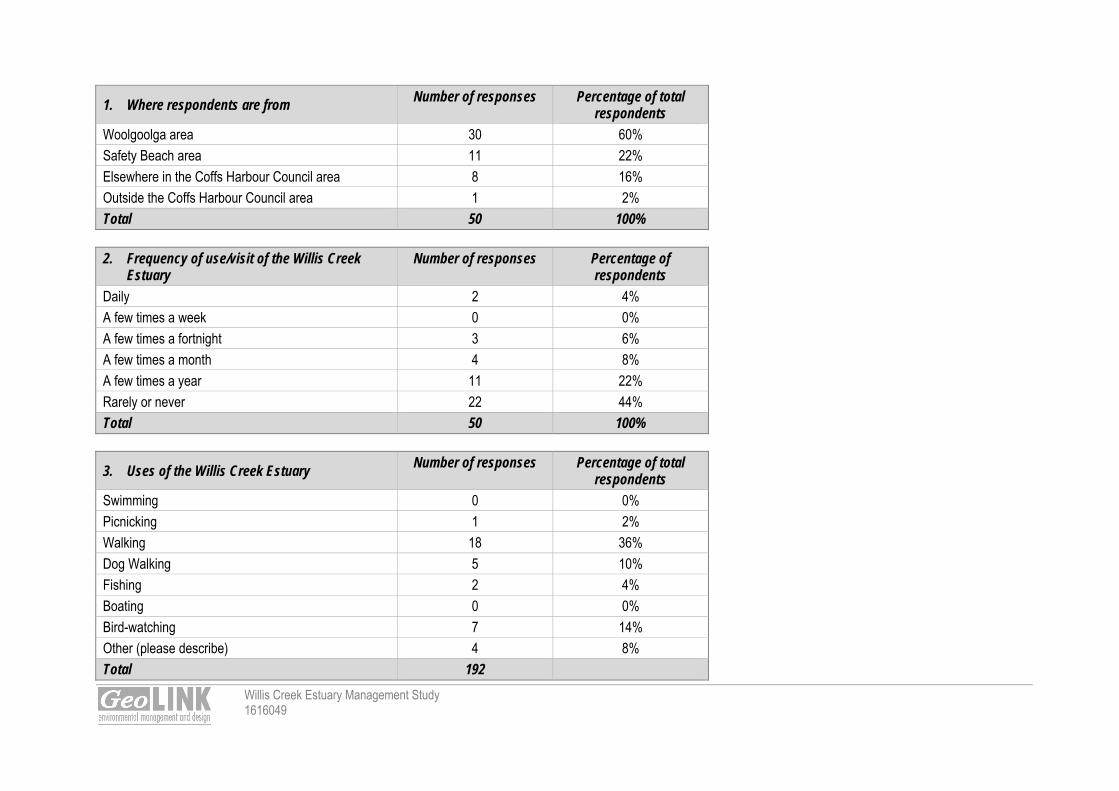
Willis Creek Estuary Management Study 1616049
1. Where respondents are from Number of responses Percentage of total
respondents
Woolgoolga area 30 60%
Safety Beach area 11 22%
Elsewhere in the Coffs Harbour Council area 8 16%
Outside the Coffs Harbour Council area 1 2%
Total 50 100%
2. Frequency of use/visit of the Willis Creek Estuary
Number of responses Percentage of respondents
Daily 2 4%
A few times a week 0 0%
A few times a fortnight 3 6%
A few times a month 4 8%
A few times a year 11 22%
Rarely or never 22 44%
Total 50 100%
3. Uses of the Willis Creek Estuary Number of responses Percentage of total
respondents
Swimming 0 0%
Picnicking 1 2%
Walking 18 36%
Dog Walking 5 10%
Fishing 2 4%
Boating 0 0%
Bird-watching 7 14%
Other (please describe) 4 8%
Total 192

Willis Creek Estuary Management Study 1616049
4. Level of concern for estuary related issues Very
Concerned Concerned Unconcerned Don't Know
Number of responses
Water quality issues associated with runoff from agricultural lands and urban areas 33 14 1 2 50
Bank erosion 28 15 5 0 48
Decline in aquatic habitat (e.g. seagrass, mangroves, wetlands) 20 20 7 0 47
Loss of native vegetation along the lake / creek shoreline 23 19 2 2 46
Protection of cultural heritage areas on the lake / creek foreshores 9 22 15 2 48
Increasing levels of sedimentation in Woolgoolga Lake 33 13 3 0 49
Sand build-up in the entrance to Woolgoolga Lake causing blocking of outflows and high flood levels
34 7 9 0 50
Erosion of the sand spit on the south side of the Woolgoolga Lake entrance 28 15 5 2 50
Diminishing fish stock in Woolgoolga Lake 27 15 4 2 50
Impact of recreational fishing on fish stocks, aquatic habitat and other fauna 20 17 8 4 49
The state of existing walkways around Woolgoolga Lake foreshores 18 16 13 1 48
Inadequate public access around Woolgoolga Lake foreshores / creeks 15 8 24 1 48
Insufficient walking tracks around Willis Creek estuary 5 12 19 10 46
Impacts of motor boats in the lake / creeks 25 12 9 1 47
Loss of foreshore habitat (e.g. seagrass, mangroves, wetlands) due to higher lake / creek waterlevels from sea level rise
13 20 12 1 46
Other (please describe) 16 3 0 1 20
Comments
Other (please describe) 9 0 0 1 10 Other concerns included: 4WDs on foreshores & lake surrounds; illegal campers in dunes; development on the foreshores and over development; litter, insufficient launching areas for kayaks/canoes; poorly constructed and unmaintained steps and pathways on the northern shore of Woolgoolga Lake and Safety Headland

Willis Creek Estuary Management Study 1616049
changes to drainage that reduce flows with no flush e.g. 27 Wharf St storm water erosion exiting onto Cabin's beach pipework is an urgent and major problem; dunes destroyed on Cabin Beach. Woolgoolga Lake needs to be regularly opened; build up of sand in these lakes prevents fish breeding and our local fish population is suffering, our breaches are being closed off for recreational fishing because of this; loss of native species both flora and fauna; and loss of edible foods; weeds around the Woolgoolga Lake and Darkum Creek has increased significantly particularly Asparagus fern and Lantana. people poisoning and cutting down trees; and loss of amenity views of the lake for residents due to the re-establishment of vegetation on the southern shore of Woolgoolga Lake, a stable area suffering from
sedimentation, not erosion.
5. Level of importance for estuary related goals Very
Important Important
Not Important
Don't Know Number of responses
Improved water quality 41 7 0 1 49
Improved runoff control on agricultural land in the catchment 33 13 1 0 47
Improved runoff control in urban areas of the catchment 38 8 0 1 46
Improved aquatic habitat within the lake and creeks to support fish stocks, crustaceans, etc. 40 7 0 1 48
Protecting the banks from erosion 34 13 0 1 48
Providing / protecting an adequate fringe of native vegetation along the lake / creek banks 32 14 1 1 48
Improved understanding of cultural heritage areas on the lake / creek foreshores 11 31 5 1 48
Continued shorebird protection measures at Willis Creek entrance (e.g. measures to protect Little Tern colony)
32 10 2 4 48
Removal of sediments in Woolgoolga Lake to provide increased water depths 30 9 8 2 49
Stabilisation of the sand spit on the south side of the Woolgoolga Lake entrance 28 14 5 2 49
Improved signage and walkway access to Woolgoolga Lake foreshore 18 14 14 1 47
Improved passive recreation facilities at Woolgoolga Lake (e.g. picnic facilities) 19 17 11 0 47
Improved walking tracks around Willis Creek estuary 11 17 11 8 47
Providing a buffer area around the shorelines to allow for 'retreat' of aquatic habitat (e.g. seagrass, mangroves) in response to rising lake/creek water levels from sea level rise
21 15 9 2 47

Willis Creek Estuary Management Study 1616049
Other comments regarding estuary goals included: stop 4WDs on the Back Beach - Willis Creek area; clean out tributaries to improve flows and water quality; dredging; maintaining tidal flows in Woolgoolga Lake would be beneficial to the community and biodiversity. more sharks and other edible creatures in the estuaries to make hunting easier for those of us that cannot afford to buy food; minimisation of human impact; protection of fish and crustaceans; protection of the Little Tern colony at the Willis Creek entrance; poor quality of walking tracks and steps need replacing with in-ground pathways as opposed to above-ground "crusher dust" type pathways. Many less-used pathways
could remain earthen and some scenic locations e.g Safety Headland, retaining wall would suit a vandal-proof, bench-like seating; a more formalised pathway could include the lake perimeter directly east of the school oval.
maintenance of weed-free, riparian vegetation around waterways and prevention of the spread of salvinia from Woolgooga Creek to Woolgoolga Lake; stop locals cutting trees down and destroying vegetation at Darkum Lake walk entrance; maintaining an adequate fire protection zone between housing and the lake foreshore bushland; maintaining aesthetics, the fewer the signs the better;
6. Artificial opening of the Woolgoolga Lake entrance Yes No Don't Know
Would you support artificial opening (with an excavator) of the lake under certain conditions? 32 9 8
7. a) Do you support the use of motor boats in the estuaries Yes No Don't Know
11 38 0
7. b) Which estuaries to you think are suitable to motor boat use? Darkum Creek Woolgoolga Lake Willis Creek
3 13 2
7. c) What type of motor boat suitable to motor boat use? Speed Boat Open runabout (tinny) Canoes with mini outboard motor
3 10 19 Comments received regarding the use of motor boats in the estuaries include: prefer a junior sailing club established on the lake foreshore; use of battery operated motors would be OK; just canoes are suitable, and oar-powered craft only; motor boats cause bank erosion, foreshore damage, noise pollution and oil/grease release;

Willis Creek Estuary Management Study 1616049
area is not large enough to accommodate motorised craft; estuaries are too shallow for motor boats; and Woolgoolga lake suitable for a small motor boat but not until it is dredged.
8. Flying Fox Colony at Woolgoolga Lake Yes No Don't Know
Are you concerned by the flying fox colony at the lake?
Comments received regarding the flying fox colony at Woolgoolga Lake include: they are an important natural pollinators; this colony is an important tourist attraction and should be promoted as such; they are an important part of the ecosystem as long as they are left alone; they smell, and cause destruction of vegetation; health, safety, ongoing disturbance, noise and pollution, and destruction of vegetation; disincentive to tourists. could carry disease; their numbers are increasing and they need culling; they chase me; effluent contaminates the lake; flying foxes are not suited to urban location; and they should be destroyed, they are disease riddled filthy pests.
9. Other Comments
Other comments received whilst I realise your main concern is humans, please give consideration to the wildlife & nature member of Northern Beaches Residents Association has Council changed the drainage behind 21-27 Wharf St? The drain no longer flushes properly, is blocked and filthy. Letter also attached with returned survey add more fish to creeks; stormwater channel and Small Creek, southern end of Cabin's Beach (rear of caravan park) is completely dead, stagnant; as a member of landcare we will welcome any help to restore the lake; the development of an estuary management plan is a step in the right direction for the future of these important assets; Woolgoolga Lake was a beautiful place for family recreation, children once learned to swim there. Lake has been spoiled by lakes closure, the siltation and the
contamination and smell of bats; get rid of the flying foxes would like to see toxicology tests on resident fish and crabs;

Willis Creek Estuary Management Study 1616049
the entire coastal area from Sapphire to Arrawarra is valuable because of the diversity of species (flora and fauna) occurring here as well as for the number of threatened species which utilise the region. In addition, it is a naturally attractive section of the NSW coastline and the natural beauty, high level of biodiversity and threatened species should be protected and promoted. This can be done in a manner which both proctects the natural amenity of the area as well as enhancing its appeal to visitors to the area;
I love Woopi Lake if it wasn’t there, I would not be here I have encountered 20 different types of fish in the lake and the birdlife is amazing. One day I saw 21 black swans arrive here at night. They left the next morning;
thank you for the opportunity to comment on this important issue; my main concern is for Woolgoolga Lake but as a child I also spent time at Darkum Creek and I have talked to people about Willis Creek. All these natural
waterways need your help. There is no point in stopping the fishing by closing up the beaches and ocean fishing if we don't protect the areas our fish need to start their life in. We need to give the lakes back to the fish, and we can still swim and paddle boat on these lakes because when there is deep water there is enough room for us and the fish. Thank you for the time you are spending working out the best way to go. Please fix our lakes;
I would fully support a Woolgoolga Lake hydrological study in support of an attempt to maintain tidal conditions in this particular waterway. I also believe water quality should be continually monitored by Council particularly for E. coli (sewerage pumps on the foreshores have failed in the past) and pesticides/herbicides. All results should be made public and dangerous results acted upon promptly and openly. Thanks for the consideration.

Appendix B
Willis Creek Estuary Management Study 1616049
B Planning Framework

Willis Creek Estuary Management Study 1616049
B.1 The NSW Coastal Zone Management Planning Process The development and implementation of Estuary Management Plans or Coastal Zone Management Plans is overseen by the Coastal Estuary Management Advisory Committee established by Coffs Harbour City Council. Coastal Zone Management Plans are prepared under the guidance of the NSW Coastal Policy 1997, Guidelines for Preparing Coastal Zone Management Plans (DECCW, 2010) and the North Coast Rivers Healthy Rivers Commission Report (HRC, 2003). A range of NSW legislation and policies are also relevant and will be discussed later is this section. The Guidelines for Preparing Coastal Zone Management Plans (DECCW, 2010) supersedes the Estuary Management Manual (NSW Government, 1992). B1.1 Guidelines for Preparing Coastal Zone Management Plans (DECCW, 2010) The Guidelines for Preparing Coastal Zone Management Plans (CZMP) (DECCW, 2010) provides a framework for and specifies minimum requirements for preparing a Coastal Zone Management Plan. These guidelines have replaced the: Coastline Management Manual 1990; and Estuary Management Manual 1992. The primary purpose of a CZMP is to describe proposed actions to be implemented by a council, other public authorities and potentially by the private sector to address priority management issues in the coastal zone over a defined implementation period. These may include: Managing risks to public safety and built assets; Pressures on coastal ecosystems; and Community uses of the coastal zone. CZMPs should support the goals and objectives of the NSW Coastal Policy 1997 and the NSW Sea Level Rise Policy Statement and assist in implementing integrated coastal zone management. The Woolgoolga Lake, Darkum Creek and Willis Creek Estuary Management Study and Plan are to be developed in accordance with the Guidelines for Preparing Coastal Zone Management Plans. . B1.3 NSW Coastal Policy 1997 The NSW Coastal Policy deals with population and economic growth whilst protecting the natural, cultural, heritage and spiritual values of the coastal environment. The policy has a strong focus on the principles of Ecologically Sustainable Development (ESD) and incorporates its four principles: the precautionary principle; inter-generational equity; conservation of biological diversity and ecological integrity; and improved valuation, pricing and incentive mechanisms. Through the principles of ESD and the principle of Integrated Coastal Zone Management (ICZM) the 1997 Coastal Policy has set out the following nine goals: protecting, rehabilitating and improving the natural environment of the coastal zone. recognising and accommodating the natural processes of the coastal zone. protecting and enhancing the aesthetic qualities of the coastal zone. protecting and conserving the cultural heritage of the coastal zone. providing for ecologically sustainable development and use of resources. providing for ecologically sustainable human settlement in the coastal zone. providing for appropriate public access and use. providing information to enable effective management of the coastal zone. providing for integrated planning and management of the coastal zone.
Willis Creek Estuary Management Study 1616049
The Coastal Policy 1997 understands that the management of coastal zones is the responsibility of State and Local Government as well as the community. ICZM is linked to the framework through the primary goal to maintain, restore or improve the quality of coastal zone ecosystem and the societies they support. The ICZM is unique in that it addresses both the development and conservation challenges for specific coastal areas of Australia. Woolgoolga Lake, Darkum Creek and Willis Creek fall within the defined coastal zone, therefore the coastal policy needs to be considered in the preparation of the Estuary Management Study and Plan. Councils are required to implement the policy when making local environmental plans applying to land within the coastal zone and to take the provisions of the policy into consideration when determining development applications in the coastal zone.
B.2 Legislative and Policy Frameworks for Estuary Management in NSW B2.1 Coastal Protection Act 1979 The NSW Coastal Protection Act 1979 aims to protect, enhance, maintain and restore the environment with concern for both the natural and built environments. The NSW Coastal Protection Act 1979 is the principal legislation relating to coastal management in New South Wales. Key provisions of the Act include requirements relating to Ministerial concurrences for certain developments in the coastal zone, and requirements relating to preparing coastal zone management plans. It also includes order powers relating to unlawful dumping of material on beaches. In 2010 the Act was amended by the Coastal Protection and Other Legislation Amendment Act 2010. This included new provisions allowing landowners to temporarily place sand or sandbags as emergency coastal protection works under certain conditions. The amendments also improved the arrangements for preparing coastal zone management plans and the ability of public authorities to require the removal of unlawful material dumped on beaches. They also increased penalties for a breach of the principal Act. The Coastal Protection Act 1979 has a strong link with the principles of ESD in that the final determination by the Minister for Planning may be rejected if the proposal is not consistent with the ESD principles. The Act also recognises the importance of the social and economic benefits which are a result of sustainable coastal environments. Woolgoolga Lake, Darkum Creek and Willis Creek are subject to the Coastal Protection Act as the coastal zone of protection includes the land one kilometre landward of coastal waters, estuaries, lakes and tidal limits of rivers; therefore having implications for the subject estuaries. B2.2 Coastal Protection Regulation 2011 The primary objective of the Coastal Protection Regulation 2011 which commenced on 3 March 2011 is to support the amendments to the Coastal Protection Act. The main provisions of the Regulation are: requirements relating to emergency coastal protection works by landowners, specified in a Code of Practice
under the Regulation and also explained in a guide to these requirements; requirements relating to Ministerial concurrences which must be obtained before carrying out certain off-
shore development activities, similar to the requirements in the Coastal Protection Regulation 2004; defining the arrangements for categorising land according to its vulnerability to coastal hazards, based on
information in council coastal zone management plans.

Willis Creek Estuary Management Study 1616049
B2.3 Environmental Planning and Assessment Act 1979 One of the key pieces of NSW legislation is the Environmental Planning and Assessment Act 1979. This Act provides a system of environmental planning and assessment for NSW, and involves developing plans to regulate land uses, through ‘environmental planning instruments’. A primary objective of the Environmental Planning and Assessment Act (EP&A Act) 1979, is the proper management, development and conservation of natural and artificial resources for the promotion of economic and social welfare and a better environment. The EP&A Act enables the creation of Local Environmental Plans and State Environmental Planning Policies which deal with land, development and resource management at the local, regional and state level. The relevant plans created under the EP&A Act that are applicable to Woolgoolga Lake, Darkum Creek and Willis Creek include the Coffs Harbour Local Environmental Plan 2000 (discussed later)and the following State Environmental Planning Policies. SEPP 14 – Coastal Wetlands The objective of SEPP 14 is to ensure that coastal wetlands are preserved and protected in the environmental and economic interests of the State. The policy provides protection to specific wetland areas that have been mapped and gazetted by Department of Planning and Infrastructure. Development that involves the following activities is not allowed to be carried out unless consent (designated development) is provided by local council and concurrence is sought from the Director General of Planning: clearing of land, construction of levees, draining of land, and filling of land. If this development is to be carried out, an Environmental Impact Statement first needs to be prepared. There is one SEPP 14 coastal wetland identified within the study area located around Willis Creek. Protection and management of this wetland is supported by the EMS which is consistent with the aims and objectives of SEPP14. SEPP 26 – Littoral Rainforest SEPP 26 aims to provide consideration for development applications which are likely to damage or destroy littoral rainforest with a view towards preserving their natural state. Council consent is required for any land directly affected by or within 100m of mapped littoral rainforest. The SEPP requires that any person shall not erect a building, carry out work, use land for any purpose, or subdivide it, disturb, change or alter any landform or disturb, remove, damage or destroy any native flora or other element of the landscape or dispose of or dump any liquid, gaseous or solid matter, without the consent of Council. The SEPP is relevant to developing the estuary management study and planand therefore all potential works should be designed to be consistent with the SEPP and consent should be sort where appropriate. Some SEPP 26 Littoral Rainforest is mapped in the vicinity of Willis Creek. SEPP44 – Koala Habitat Protection State Environmental Planning Policy 44 – Koala Habitat aims to encourage the conservation and management of areas of natural vegetation that provide habitat for koalas to ensure a permanent free-living population over their present range and reverse the current trend of population decline. SEPP44 requires that consent authorities must not issue a development approval without prior investigation of potential and core koala habitat. As Coffs Harbour has a Koala Plan of Management, the SEPP does not apply to the Coffs Harbour Local Government Area. The estuary management plan must be consistent with the Koala plan of management. SEPP 71 – Coastal Protection SEPP 71 aims to protect and manage the natural, cultural, recreational and economic attributes of the NSW coast through the use of the Ecologically Sustainable Development principles. More specifically this is achieved

Willis Creek Estuary Management Study 1616049
through the protection and preservation of public access, aboriginal heritage, visual amenity, beach environments, native coastal vegetation, marine environments, rock platforms and management of coastal zones. Clause 9 of SEPP 71 refers to Significant coastal development.(1) This Part applies to: (a), (b) (Repealed) (c) development within 100m below mean high water mark of the sea, a bay or an estuary, and (d) development on land described in Schedule 3, Subject to subclause (2) (2) This Part does not apply to:
(a) development in relation to which, under another environmental planning instrument, development consent cannot be granted without the concurrence of the Minister or the Director-General, or (b) development in relation to which, under another environmental planning instrument, the Minister or the Director-General is the consent authority.
(3) Despite subclause (2), this Part does apply to development in relation to which, under: (a) State Environmental Planning Policy No 1—Development Standards, or (b) State Environmental Planning Policy No 14—Coastal Wetlands, or (c) State Environmental Planning Policy No 26—Littoral Rainforests, development consent cannot be granted without the concurrence of the Director-General, whether or not the concurrence may be lawfully assumed. Woolgoolga Lake, Darkum Creek and Willis Creek are within the NSW Coastal Zone as defined by the Coastal Protection Act 1979. Consequently, SEPP71 is applicable and requries consideration during the development of management strategies and during implementation. SEPP (Infrastructure) 2007 SEPP (Infrastructure) 2007 came into force in January 2008 and was an amalgamation of several repealed SEPPs in order to facilitate the effective delivery of infrastructure across the State. The repealed SEPP 35 – Maintenance Dredging of Tidal Waterways in now included as a part of SEPP (Infrastructure). The SEPP: outlines planning processes for considering classes of public infrastructure and particular infrastructure
projects; exempts some minor public infrastructure from the need for an approval; clarifies where new infrastructure can be located and provides for additional permissible uses on
government land; and requires State agencies constructing infrastructure to consult local councils when a new infrastructure
development is likely to affect existing local infrastructure or services. Division 25 of the SEPP under Waterway or Foreshore Management Activities permits without consent certain development for the purposes of waterway or foreshore management activities carried out by or on behalf of a public authority. These include: Construction works; Routine maintenance works; Emergency works, including work required as a result of flooding, storms or coastal erosion; and Environmental management works. Maintenance dredging at Woolgoolga Lake, Darkum Creek and / or Willis Creek may be required in the future in order to maintain the natural flow and ecological processes, therefore SEPP (Infrastructure) is considered relevant.

Willis Creek Estuary Management Study 1616049
These works and consent requirements (or lack of) are considered relevant to the preparation of an EMP. North Coast Regional Environmental Plan (Deemed SEPP) Regional plans have been repealed and a number of regional plans are now deemed to be SEPPs. The North Coast Regional Environmental Plan 1988 (deemed SEPP) aims to protect the natural environment whilst maintaining a development that promotes economic and social benefit. The North Coast Regional Environmental Plan draws from other policies to formulate a regional focus in order to develop policies that deal with regionally specific issues. This planning document guides local environmental plans so as to control development within the region and define future land use and development. B2.4 Threatened Species Conservation Act 1995 The Threatened Species Conservation Act 1995 deals with the identification of threatened species, ecological communities and the threatening processes whilst aiming to conserve biodiversity and promote ecologically sustainable development. The Act also aims to minimise the external threats which may upset or disturb the functioning of the threatened or endangered species. A licence is required in order to harm or remove any threatened species or ecological community. Other aspects addressed in the Act include: Critical habitat identification; Recovery plans for threatened species, populations and communities; Threat abatement plans to manage threatening processes; Threatened species priorities action statements; Correct licensing; and Biodiversity banking. The Threatened Species Conservation Act 1995 applies to the areas of Woolgoolga Lake, Darkum Creek and Willis Creek as many threatened species listed under the TSC Act are present in the study area. The Act will assist in implementing strategies to ensure habitat protection and conservation within the estuaries catchments. It is noted that the NSW Biobanking Scheme is established under this Act. However, it is considered the Biobanking Scheme will not influence the development of the relevant EMP(s) other than potentially protecting areas that would otherwise not be protected by application of the biobank site tool. B2.5 National Parks and Wildlife Act 1974 The National Parks and Wildlife Act 1974 is responsible for the establishment of the National Parks and Wildlife Service which is now integrated into the Office of Environment and Heritage. The objectives of the National Parks and Wildlife Act include: The conservation of nature; The conservation of objects, places or features of cultural value within the landscape; Fostering public appreciation understanding and enjoyment of nature and cultural heritage and their
conservation; and Providing for the management of land reserved under this Act. According to the NP&W Act it is an offence to harm threatened species; buy, sell or possess threatened species; damage critical habitat; or damage the habitat of a threatened species without the issuing of a Section 120 licence. If any identified archaeological sites or remains need to be removed or destroyed, prior to commencement of management works, an approval is required from the Office of Environment and Heritage. The Act also requires a Plan of Management to be prepared for National Parks and this plan provides the framework for park use and management. The EMP will need to be consistent with relevant plans of management if any management strategies involve works in a National Park. No National Parks occur within the Woolgoolga Lake, Darkum Creek and Willis Creek

Willis Creek Estuary Management Study 1616049
Estuary Management Study Area, however the Coffs Coast Regional Park is located within the study area and is under the management of National Parks and Wildlife. No Plan of Management affects the Coffs Coast Regional Park. B2.6 Fisheries Management Act 1994 The Fisheries Management Act 1994 aims to conserve, develop and share the fishery resources of the State for the benefit of present and future generations. The Fisheries Management Act is the primary piece of legislation that protects the aquatic flora and fauna. The aims are achieved by; Conserving fish stocks and habitats; Conserving threatened species and ecological communities; Promoting ecological sustainable development; Promoting quality and viable recreational and commercial fishing; and Providing social and economic benefits for the wider community of New South Wales. NSW Fisheries which is a part of the Department Trade and Investment under Primary Industries is the regulatory body of the Fisheries Management Act. Under the Act, removal of or damage to seagrass and mangroves requires a permit to be obtained from NSW Trade and Investment. The Woolgoolga Lake, Darkum Creek and Willis Creek study areashas several areas of mangroves. Work proposed in the EMP that will impact on the mangroves or other threatened species or their habitats requires approval from NSW Trade and Investment. Dredge or reclamation works are also restricted. Any dredge or reclamation to be carried out by or on behalf of a public authority (other than a local authority) must seek concurrence from the minister and consider any comments received before undertaking the works. A local government authority must not carry out dredging or reclamation work except under the authority of a permit issued by the Minister. A person must not carry out dredging or reclamation work except under the authority of a permit issued by the Minister. B2.7 Protection of the Environment Operations Act 1997 The Protection of the Environment Operations Act 1997, aims to protect, restore and enhance the quality of the environment in New South Wales, recognising the need for ecologically sustainable development. The Act provides opportunities for the public to be involved in environmental protection as well as information about pollution. The Act addresses pollution of the air, water and land as well as noise pollution. An environmental protection licence is required for any form of pollution under the Act. Licences are issued by the Office of Environment and Heritage. There is at least one scheduled activity pursuant to the Protection of the Environment Operations Act 1997 within the estuary study area, being theWoolgoolga waste water treatment facility. Reference and review of the existing Environmental Protection Licenses for scheduled activities may be required. B2.8 Crown Lands Act 1989 The Crown Lands Act is administered by the Crown Lands Division within the Department of Primary Industries (formerly managed by the Land and Property Management Authority) to provide for the administration and management of crown land in the eastern and central division of the State. Crown land shall not be occupied, used, sold, leased, licensed, dedicated or reserved or otherwise dealt with unless the occupation, use, sale, lease, licence, reservation or dedication or other dealing is authorised under this Act. The Crown Lands Division is the custodian of crown land status information and administers crown land held under lease, licence or permit under the Crown Lands Act. The Division also manages vacant crown land, land retained in public ownership for environmental protection purposes and the lands of the crown public roads network. Crown land is commonly allocated for public uses, including schools, hospitals, sports grounds,

Willis Creek Estuary Management Study 1616049
community recreation and housing development. Crown reserves are managed in partnership with both councils and local community groups. The goal of crown Land management is to optimise environmental, economic and social outcomes for the benefit of the people of NSW. Clause 11 of the Crown Lands Act 1989 outlines the Principals of Crown land management as follows: For the purposes of this Act, the principles of Crown land management are:
(a) that environmental protection principles be observed in relation to the management and administration of Crown land,
(b) that the natural resources of Crown land (including water, soil, flora, fauna and scenic quality) be conserved wherever possible,
(c) that public use and enjoyment of appropriate Crown land be encouraged, (d) that, where appropriate, multiple use of Crown land be encouraged, (e) that, where appropriate, Crown land should be used and managed in such a way that both the land and its
resources are sustained in perpetuity, and (f) that Crown land be occupied, used, sold, leased, licensed or otherwise dealt with in the best interests of
the State consistent with the above principles. The main areas of Crown Lands within the study area would include the bed and potentially some foreshore area of Willis Creek and associated tributaries. Beach, foreshore land and the Coffs Coast Regional Park would also be Crown Land. Catchment management activities that impact on Crown Land must be referred to the Crown Lands Division. B2.9 Local Government Act 1993 The Local Government Act 1993 provides the legal framework for an effective, efficient, environmentally responsible and open system of local government in NSW. Council’s responsibilities are outlined in the Act and include ‘to properly manage, develop, protect, restore, enhance and conserve the environment of the area for which it is responsible, in a manner that is consistent with and promotes the principles of ecologically sustainable development’. According to the provisions of the Act, Councils have numerous functions. Chapter 6 of the Act requires that all land vested in Councils must be classified as either community or operational land. Community land is land which should be kept for use by the general public (e.g. a public park). Councils must prepare plans of management to guide the use and management of community land. Core objectives are defined in the Act for the management of different types of community land. Plans of management prepared for community land within the study area should be generally consistent with the principles of an EMP. B2.10 Water Management Act 2000 The Water Management Act, 2000 provides an integrated legislative framework for all water resources in the state including groundwater and estuarine and coastal waters to the three nautical mile limit. The overarching objectives of this Act are to provide for the sustainable and integrated management of the water sources of the State for the benefit of both present and future generations and, in particular: (a) to apply the principles of ecologically sustainable development, and (b) to protect, enhance and restore water sources, their associated ecosystems, ecological processes and biological diversity and their water quality, and (c) to recognise and foster the significant social and economic benefits to the State that result from the sustainable and efficient use of water, including:
(i) benefits to the environment, and (ii) benefits to urban communities, agriculture, fisheries, industry and recreation, and (iii) benefits to culture and heritage, and

Willis Creek Estuary Management Study 1616049
(iv) benefits to the Aboriginal people in relation to their spiritual, social, customary and economic use of land and water,
(d) to recognise the role of the community, as a partner with government, in resolving issues relating to the management of water sources, (e) to provide for the orderly, efficient and equitable sharing of water from water sources, (f) to integrate the management of water sources with the management of other aspects of the environment, including the land, its soil, its native vegetation and its native fauna, (g) to encourage the sharing of responsibility for the sustainable and efficient use of water between the Government and water users, (h) to encourage best practice in the management and use of water. Under the Act, various licences and permits may be required. For example, development / works on water front land (within 40m of a water course) may require a Controlled Activity Approval and extraction of water from a water course may require an Access Licence. These would be sought from the NSW Office of Water and generally trigger integrated development. B2.11 Other Relevant Acts B2.11.1 Native Vegetation Act 2003 Native Vegetation Act 2003 repealed the Native Vegetation Conservation Act 1997 and regulates the clearing of native vegetation on all land in New South Wales, except for land listed under schedule 1 of the Act. The objectives of the Act are to, in accordance with the principles of ecologically sustainable development: encourage and promote the management of native vegetation in the social, economic and environmental
interests of the State, prevent clearing unless it improves or maintains the environmental outcome, protect high conservation value native vegetation with regard to water quality, biodiversity, or the prevention
of salinity or land degradation, improve the condition of existing native vegetation, and encourage rehabilitation and revegetation of land with appropriate native vegetation, The NV Act aims to promote the management of native vegetation as well as prevent broad scale clearing unless it improves or maintains environmental outcomes. The Act states that native vegetation must not be cleared except in accordance with: a development consent granted in accordance with this Act, or a property vegetation plan. Land to which this Act does not apply: SEPP 14 – coastal wetlands SEPP 26 – littoral rainforests Land reserved under National Parks and Wildlife Act. The clearing of native vegetation can only be granted by development consent in accordance with the Act or a property vegetation plan. Vegetation clearing would not normally be recommended under an Estuary Management Plan. Existing NV Act approaches to vegetation management (such as property vegetation plans) in the EMP could be adopted to assist in implementation. B2.11.2 Catchment Management Authorities Act 2003 The Catchment Management Authorities Act 2003 repealed the Catchment Management Act and established 13 Catchment Management Authorities (CMA) across New South Wales. CMAs aimed to create natural resources management by the use of catchment boundaries and are aimed at being an inclusive organisation with participation from local organisations, conservation groups, landholders and uses. Darkum Creek, Woolgoolga Lake and Willis Creek and associated catchment falls within the Northern Rivers CMA (NRCMA) therefore the Northern Rivers Catchment Action Plan (NRCAP) is applicable. The CAP:
Willis Creek Estuary Management Study 1616049
Identifies and provides long term direction in addressing the sustainable management of our natural resources.
Establishes repair and rehabilitation work, with Government funds within the catchment. Directs incentive projects to maximise the environmental outcomes. There are several themes within the NRCAP that are appropriate for the catchments of Darkum Creek, Woolgoolga Lake and Willis Creek: Community; increase the contribution of the community towards natural resource management (NRM). Land use planning; natural resources and Aboriginal cultural landscapes are sustainably managed with
regard to urban development as well as incorporated into local and regional planning frameworks. Biodiversity; the condition of native and aquatic ecosystems are improved. Water; improvements are made towards river and aquifer conditions. Coastal Management; natural resources within the Coastal Zone are improved Marine; the health of the marine environment is improved. Soil/Land Resource; improve soil condition so as to support agricultural production and natural ecosystem
functions in a sustainable manner.
The EMP shall be prepared to be generally consistent with the NRCAP objectives. B2.11.3 Heritage Act 1977 The Heritage Act 1977 protects heritage items, sites, and relics and is administered by the Office of Environment and Heritage. A relic is defined as any item relating to European settlement that is older than 50 years. According to Section 139 an excavation permit must be obtained from the NSW Heritage Office for the excavation or disturbance of a relic. EMP management strategies must ensure they do not detrimentally impact on heritage and proposed items listed under this Act. B2.11.4 Noxious Weeds Act 1993 The Noxious Weeds Act 1993 identifies noxious weeds and specific control measures and duties of public and private landholders. The Act provides a framework for the state wide control of noxious weeds by the Minister and local control authorities. The EMP can support the management of weeds through incorporating the management strategies contained within the Act for the categories of noxious weeds listed. B2.11.5 Protection of the Environment Administration Act 1991 The Protection of the Environment Administration Act 1991 establishes the Environmental Protection Authority (now known as the Office of Environment and Heritage (OEH) – formerly Department of Environment, Climate Change and Water). One of OEHs objectives is to report on the state of the environment. The primary objective of OEH is to protect, restore and enhance the quality of the environment but also to integrate economic considerations into decision making. . The objectives of the POEA Act must be taken into consideration in preparing an EMP. B2.11.6 Natural Resources Commission Act 2003 The Natural Resource Commission Act 2003 established the independent body the Natural Resource Commission to deal with the investigation and reporting of the use and management of natural resources in NSW. The Commission has the following objectives as established in the Act: establish a sound scientific basis for the properly informed management of natural resources in the social,
economic and environmental interests of the State; and enable the adoption of State-wide standards and targets for natural resource management issues; and
Willis Creek Estuary Management Study 1616049
advise on the circumstances in which broadscale clearing is to be regarded as improving or maintaining environmental outcomes for the purposes of the Native Vegetation Act 2003.
The commission established the Standard for Quality Natural Resource Management which provides a standard for quality assurance in NSW. Thirteen state wide targets for NRM where adopted in the State Plan which will provide guidance and reference for the development of the EMP. The commission also investigates natural resources management with regard to social, economic and environmental interests in order to standardise targets for natural resource management issues. In addition, the Minister for Planning is required to consult with the commission on certain development in coastal areas. B2.11.7 Environment Protection and Biodiversity Conservation Act (Commonwealth) 1999 The Environment Protection and Biodiversity Conservation Act 1999 (EPBC Act) provides a legal framework in which nationally and internationally important flora, fauna, ecological communities and heritage sites are managed and protected. It is this framework which forms the basis of the federal government’s environmental legislation. The EPBC Act applies to the following seven matters of national environmental significance; World heritage sites; National heritage places; Wetlands of international importance; Nationally threatened species and communities; Migratory species; Commonwealth marine areas; and Nuclear actions. Management outcomes from the EMP shall be designed and implemented to ensure consistency with the Commonwealth responsibilities under the Act, most notably in relation to wetlands, nationally threatened species and migratory species. The Solitary Islands Marine Park encompasses much of the coastal area adjacent to Woolgoolga, stretching over 75 km from Muttonbird Island in the south to the Sandon River and Plover Island in the north. The marine park incorporates estuaries to their tidal limit, foreshores to the mean high water mark and extends offshore to the 3 nautical mile state waters boundary. This Marine Park is included under national heritage listings. B2.12 Solitary Islands Marine Park AS mentioned above, the Solitary Islands Marine Park encompasses much of the coastal area adjacent to Woolgoolga, stretching over 75 km from Muttonbird Island in the south to the Sandon River and Plover Island in the north. The marine park incorporates estuaries to their tidal limit, foreshores to the mean high water mark and extends offshore to the 3 nautical mile state waters boundary. The Marine Park covers an area of around 72 200 hectares. Marine parks help conserve the State’s marine life for present and future generations, whilst providing a great opportunity to improve public appreciation, understanding and enjoyment of our unique marine environment. Many activities undertaken within the Marine Park require a permit from the Marine Parks Authority. The Solitary Islands Marine Park Zoning Plan identifies activities that can occur without specific permission and those that require a permit. Examples of activities undertaken within the Marine Park requiring permits include: Commercial activities; Organised events (including all local club competitions); Research; and Collecting for private aquariums. For full details of activities permitted in zones please refer to the Marine Parks Regulation 1999. The Solitary Islands Marine Park is a multiple use park with a comprehensive zoning scheme designed to protect the natural values and sensitive areas as well as provide for continued recreational and commercial use. There are four zones in the park as outlined below.

Willis Creek Estuary Management Study 1616049
Sanctuary Zone: Or “no-take” areas provide the highest level of protection to habitat, animals and plants by prohibiting all forms of fishing and collecting activities, and anchoring on reefs. Activities that do not harm plants, animals and habitats are permitted.
Habitat Protection Zone: Conserve marine biodiversity by protecting habitats and reducing high impact activities. Recreational fishing, some forms of commercial fishing, tourist activities and fishing competitions are permitted in habitat protection zones. However, only certain species may be taken from habitat protection zones.
General Use Zones: Provides for a wide range of activities including both commercial and recreational fishing. All standard NSW fishing regulations and bag limits apply. All forms of setline/dropline, longline, purse seine net fishing and estuary mesh netting are prohibited in the Marine Park. Commercial aquarium collecting is also prohibited.
Special Purpose Zones: Four special purpose zones are included in the Marine Park and provide for: management of oyster leases in Sandon and Wooli Wooli Rivers; Aboriginal cultural use, research or rehabilitation in Pipe Clay Lake and at Arrawarra Headland.
Willis Creek is designated as a Habitat Protection Zone up to its tidal limit. The park’s operational plan (2003) outlines how the Marine Park Authority will manage the Solitary Islands Marine Park in a sustainable way that is consistent with the objectives of the Marine Parks Act 1997. The plan identifies actions in such areas as: conservation of biodiversity and maintenance of ecological processes ecologically sustainable use Indigenous culture non-Indigenous heritage values research and monitoring community education and involvement compliance permits management arrangements with the Commonwealth Government (the MPA manages the Commonwealth’s
Solitary Islands Marine Reserve on a day-to-day basis). B2.13 Marine Parks Act 1997 and Marine Parks (Zoning Plan) Regulations 1999 The objects of this Act are as follows:
(a) to conserve marine biological diversity and marine habitats by declaring and providing for the management of a comprehensive system of marine parks,
(b) to maintain ecological processes in marine parks, (c) where consistent with the preceding objects:
(i) to provide for ecologically sustainable use of fish (including commercial and recreational fishing) and marine vegetation in marine parks, and
(ii) to provide opportunities for public appreciation, understanding and enjoyment of marine parks. The Marine Parks Regulation 1999 provides details of activities permitted in the above listed Marine Park zones. The following relates to activities within the Habitat Protection Zone which affects Willis Creek to its tidal limit: Subdivision 3 Habitat protection zone 1.16 Protection of animals, plants and habitat in habitat protection zone (1) A person must not, while in the habitat protection zone of a marine park:
(a) harm, or attempt to harm, any animal (other than fish), or (b) harm, or attempt to harm, any plant, or (c) damage, take or interfere with, or attempt to damage, take or interfere with, any part of the habitat (including soil, sand, shells or other material occurring naturally within the zone),

Willis Creek Estuary Management Study 1616049
except with the consent of the relevant Ministers. Maximum penalty: 100 penalty units. (2) Consent is only to be given under subclause (1):
(a) for research, environmental protection, public health, traditional use or public safety purposes, or (b) for the purposes of an ecologically sustainable use that does not have a significant impact on fish populations within the zone or on any other animals, plants or habitats.
(3) A contravention of subclause (1) is designated as a forfeiture offence. Activities such as, but not limited to, management, environmental, commercial and recreational activities would need to be consistent with the Marine Parks Act and Regulations and the Solitary Island Marine Park Plan where it applies to Willis Creek.
B.3 Coffs Harbour City Council Planning Framework B.3.1 Coffs Harbour Local Environmental Plan 2000 The entire study area of Darkum Creek, Woolgoolga Lake and Willis Lake and their catchments are within the Coffs Harbour local government area. The Coffs Harbour Local Environmental Plan 2000 describes the Local Government area in regard to zoning and what development is permissible within each zone. The zoning arrangements within the catchments of Darkum Creek, Woolgoolga Lake and Willis Creek include a great diversity of zoning types and therefore zoning / development objectives and controls. No one zone clearly affects the majority of catchments or areas surrounding the estuaries. Urban zonings and development is located close to most of these estuarine areas. Areas of open space and recreation are designated around Woolgoolga Lake. Limited environmental protection zonings exist in the vicinity of these estuaries, expect for that of Willis Creek. Coffs Harbour City Council is still in the process of preparing a draft LEP to be consistent with the Standard Instrument – Principal Local Environmental Plan (SLEP). Therefore the current LEP is the main relevant local planning instrument. According to the SLEP, there are three waterway zones that may be applicable to waterways: Zone W1 Natural Waterways Zone W2 Recreational Waterways Zone W3 Working Waterways Applying the most appropriate zoning will need to consider the tenure, anticipated usage and any land use protective or management measures. B.3.2 Coffs Harbour Local Government Development Control Plans The Coffs Harbour Local Government Development Control Plans (DCPs) establish requirements that are specific to different types of development as well as particular locations. The DCP is used as an addition to the LEP providing more specific development advice and they are created by the Environmental Planning and Assessment Act 1979. There are numerous DCPs which apply to the Coffs Harbour Local Government Area, the majority of which do not apply to the catchment areas of Darkum Creek, Woolgoolga Lake or Willis Creek. At the time of implementation of the estuary management plans, site specific DCPs should be reviewed for consistency. The following general DCPs may need to be considered in preparing the EMP: Residential Tourist Lands DCP; West Woolgoolga DCP; Hearnes Lake / Sandy Beach DCP; B.3.3 Coastal Processes and Hazard Definition Study

Willis Creek Estuary Management Study 1616049
Under recent changes to the NSW Coastal Protection Act 1979, councils along the NSW coast are now required to determine the risk of coastal erosion and sea level rise on their LGAs. The Coffs Harbour Coastal Processes and Hazards Definition Study is the first step in developing a Coastal Zone Management Plan to help tackle such risks in the Coffs Harbour LGA. The Study contains a thorough technical assessment of the possible threats posed by climate change, extreme weather and sea level rise. The Coffs Coastal Processes and Hazards Definition Study was developed by BMT WBM Pty Ltd consultants. Using the NSW Government's scientific guidelines and forecast sea level rise, it investigates the coastal processes occurring along the Coffs Harbour LGA coastline and the extent of the coastal hazards arising from these processes. The Study looks at the likelihood of either coastal erosion or coastal inundation during extreme weather at three different timescales. These are 'Immediate', in the year '2050' and in the year '2100'. At each of these timescales, maps and hazard lines have been developed for the LGA that show erosion or inundation on the basis of 'almost certain', 'unlikely' and 'rare'.
B.4 Government Policy and Estuaries B.4.1 NSW Government Sea Level Rise Policy Statement In response to sea level rise the State government has released the NSW Government Sea Level Rise Policy Statement, it sets out the risks to property owners from coastal processes and assistance that Government provides to councils to reduce the risks of coastal hazards. The aim of the Government is to create a smooth transition in the adaptation to sea level rise with disruptions to the social, economic and environmental aspects of society. The Government intends to support the community and Council by: Promoting an adaptive risk-based approach to managing the impacts of sea level rise; Providing guidance to local councils to support their sea level rise adaption planning; Encouraging appropriate development on the land projected to be at risk from sea level rise; Continuing to provide emergency management support to coastal communities during time of floods and
storms; and Continuing to provide up-to-date information to the public about sea level rise and its impacts. B.4.2 NSW State Plan 2006 The primary purpose of the NSW State Plan 2006 is for greater efficiencies and better allocation of Government services for the NSW community. The State Plan focuses on five key areas: Rights, Respect and Responsibility; Delivering Better Services; Fairness and Opportunity; Growing Prosperity Across NSW; and Environment for Living. These key areas formulate the goals that have been generated through extensive community consultation and reflect what the community wants the Government to achieve over the next 10 years. Whilst the plan is not all-encompassing it does prioritise the goals by dealing with greatest community concerns first. The Environment for Living is the area primarily linked with estuary managementwith particular regard to the following: E1 – A secure and sustainable water supply for all users. This priority identified by the Government allows
for greater efficiencies in water supply reliability and quality as well as water recycling efficiencies. E4 – Better outcomes for native vegetation, biodiversity, land, rivers and coastal waterways. The natural
environment is a major player in the economic and social health of communities, tourism on the Macleay River is staple industry for the area.

Willis Creek Estuary Management Study 1616049
E8 – More people using parks, sporting and recreational facilities and participating in the arts and cultural activity. The priority is applicable to this estuary management plan in that it considers actions that may increase the number of State Government park visitors.
B.4.3 Healthy Rivers Commission – Independent Inquiry into Coastal Lakes 2002 The Healthy Rivers Commission highlighted the lack of understanding about the ecological process at work within coastal lake systems. The lack of understanding has resulted in detrimental consequences to the natural environment as well as the commercial activities these lakes support. In order to improve the management of coastal lakes and their catchments, the Coastal Lakes Strategy incorporates the following six components: principles for managing coastal lakes; a framework for managing major classes of coastal lake; a classification of coastal lakes; requirements for preparing and implementing Sustainability Assessment and Management Plans for each
coastal lake; implementation arrangements; and a range of supporting initiatives. One of the central features of the strategy is that management needs to address the whole system and not just specific sites. This inclusive view allows for issues and their implications to be identified and dealt with in a manner which would promote the principles of ecologically sustainable development. There are four classifications for the Coastal Lakes: Comprehensive Protection; Significant Protection; Healthy Modified Conditions; and Targeted Repair.
These classifications allow for specific goals to be created for each lake thereby providing a basis for an achievable management plan. The classification focuses on the natural environment but allows for social and economic considerations thus addressing the principles of Ecologically Sustainable Development . B.4.4 NSW Wetlands Management Policy 2010 Originally introduced in 1996, the NSW Wetlands Management Policy was updated in 2010 to reflect developments in natural resource management and planning that affect wetlands. The policy aims to encourage better management of NSW wetlands by halting and, where possible, reversing the loss of wetland vegetation, declining water quality, declining natural productivity, loss of biological diversity and declining natural flood mitigation functions. It also aims to encourage projects and activities that will restore the quality of NSW wetlands, by rehabilitating wetlands, re-establishing buffering vegetation and ensuring adequate water retention. B.4.5 NSW State Rivers and Estuaries Policy 1993 Although published in 1993 and a number of organisational and legislative changes have occurred since that time, the overarching objectives and principles of the policy remain the same today. The overarching objectives of the policy are to manage the rivers and estuaries of NSW in ways which: Slow, halt or reverse the overall rate of degradation in the systems; Ensure the long term sustainability of their essential bio-physical functions; and Maintain the beneficial use of these resources. To achieve these objectives, the policy adopts six key principles: Those uses of rivers and estuaries which are non-degrading should be encouraged; Non-sustainbale resources uses which are not essential should be phased out;

Willis Creek Estuary Management Study 1616049
Environmental degrading processes and practices should be replaced with more efficient and less degrading alternatives;
Environmentally degraded areas should be rehabilitated and their biophysical functions restored; Remnant areas of significant environmental value should be accorded special protection; and An ethos for sustainable management of river and estuarine resources should be encouraged in all agencies
and individuals who own, manage or use these resources.