17839 the use of retrospective data for creating 3d models
TRANSCRIPT
Geoinformatics 2020 11-14 May 2020, Kyiv, Ukraine
17839
The use of retrospective data for creating 3D models оn the example of the Balakhivka graphite deposit
N. Safronova (Geological Service Company LLC)
SUMMARY
The creation of an electronic archive, database of retrospective data and their use for creating 3D model is considered оn the example example of the Balakhivka graphite deposit.
Geoinformatics 2020
11-14 May 2020, Kiev, Ukraine
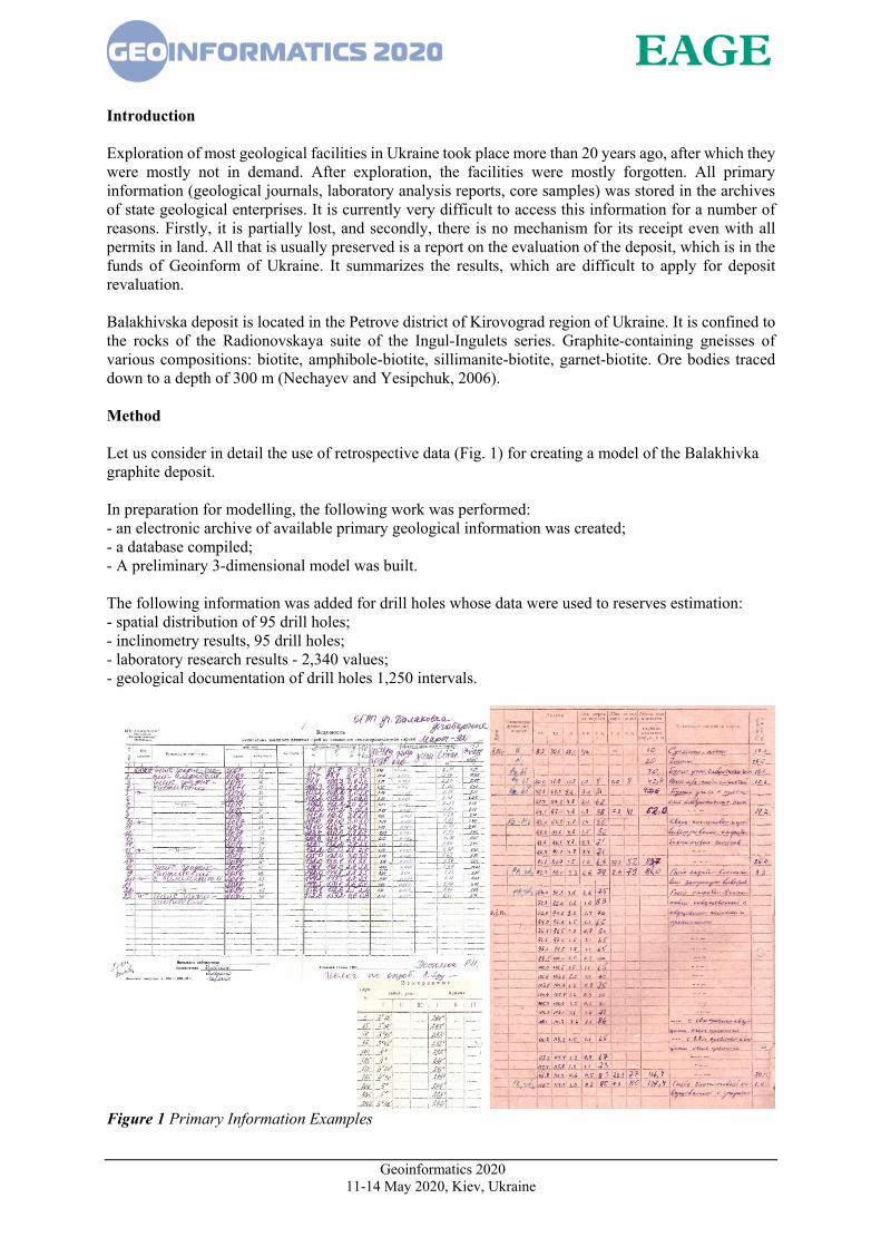
Introduction Exploration of most geological facilities in Ukraine took place more than 20 years ago, after which they were mostly not in demand. After exploration, the facilities were mostly forgotten. All primary information (geological journals, laboratory analysis reports, core samples) was stored in the archives of state geological enterprises. It is currently very difficult to access this information for a number of reasons. Firstly, it is partially lost, and secondly, there is no mechanism for its receipt even with all permits in land. All that is usually preserved is a report on the evaluation of the deposit, which is in the funds of Geoinform of Ukraine. It summarizes the results, which are difficult to apply for deposit revaluation. Balakhivska deposit is located in the Petrove district of Kirovograd region of Ukraine. It is confined to the rocks of the Radionovskaya suite of the Ingul-Ingulets series. Graphite-containing gneisses of various compositions: biotite, amphibole-biotite, sillimanite-biotite, garnet-biotite. Ore bodies traced down to a depth of 300 m (Nechayev and Yesipchuk, 2006). Method Let us consider in detail the use of retrospective data (Fig. 1) for creating a model of the Balakhivka graphite deposit. In preparation for modelling, the following work was performed: - an electronic archive of available primary geological information was created; - a database compiled; - A preliminary 3-dimensional model was built. The following information was added for drill holes whose data were used to reserves estimation: - spatial distribution of 95 drill holes; - inclinometry results, 95 drill holes; - laboratory research results - 2,340 values; - geological documentation of drill holes 1,250 intervals.
Figure 1 Primary Information Examples

Geoinformatics 2020
11-14 May 2020, Kiev, Ukraine
All paper-based materials were scanned and put in folders with the corresponding names. The archive structure is shown in Fig. 2.
Figure 2 Archive structure In the raw database, description of the rocks was given in free form in terms of the original version. For convenience of further work, all interval rock names were unified and divided into 16 lithologic varieties, the names of which in the database are given in English (Fig. 3). For all lithological varieties, a color coding has been developed (Fig. 4) for visual expression in the three-dimensional environment. As a result, the database consists of four main files (Collar, Inclination, Geology, Assay). The Collar file contains general drill holes information. Main information fields: CR-SECT - profile number; Hole-ID – drill hole number; East, North - the coordinates of the collar in the coordinate system GK42; RL - altitude above sea-level; Depth - depth. Inclination file - spatial position of drill holes. Main information fields: DHID - drill hole number, Depth - measurement depth, Dip 90 - angle of drilling, Azimuth - direction of drill. Geology file - a file containing results of geological documentation of core samples with a description of lithological varieties of rocks. Main information fields: Hole-ID - well number; Code - unified breed code (in English); Core recovery, m - core output; Core recovery,% - core output; FROM - depth of the beginning of the interval (m); TO - depth of the end of the interval (m); Interval - power (m); Geology - breed description (in Russian); Graphite - information about graphite contents visually indicated in the documentation. Assay file - sample interval data and corresponding laboratory test results. Main information fields: Cross Section - profile number; DHID - drill hole number; Rock - breed; ID sample - sample number; FROM - depth of the interval start (m); TO - depth of the interval end (m); Interval - thickness (m); C (graphite) - graphite grade (%); C (carbon) - carbon grade (%); C (general) - total carbon grade (%); Moist - humidity; Core recovery, m - core output; Core recovery,% - core output; East, North - sample coordinates; Rl - altitude.

Geoinformatics 2020
11-14 May 2020, Kiev, Ukraine
Figure 3 Database of the Balahivka deposit – table structure The geological interpretation was performed by contouring the geological bodies in the profiles using lithological control and composite samples, with cut-off grade 1% (Fig. 4) (Bariatska et al., 2018).
Figure 4 Delination of geological bodies in profile The wireframe modeling method was used to create a three-dimensional model of the Balakhivka graphite deposit (Fig. 5) (Bariatska and Safronova, 2019).
Figure 5 Wireframe model of the Balakhivka graphite deposit
Geoinformatics 2020
11-14 May 2020, Kiev, Ukraine
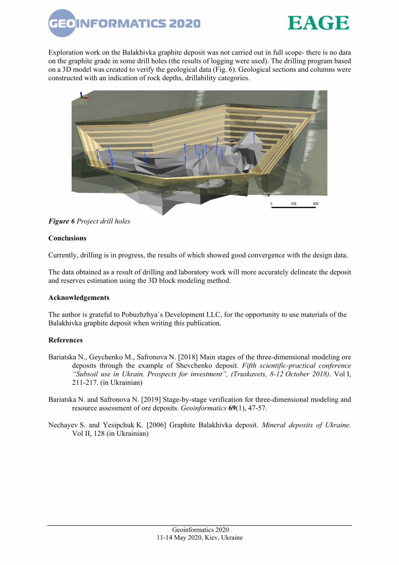
Exploration work on the Balakhivka graphite deposit was not carried out in full scope- there is no data on the graphite grade in some drill holes (the results of logging were used). The drilling program based on a 3D model was created to verify the geological data (Fig. 6). Geological sections and columns were constructed with an indication of rock depths, drillability categories.
Figure 6 Project drill holes Conclusions Currently, drilling is in progress, the results of which showed good convergence with the design data. The data obtained as a result of drilling and laboratory work will more accurately delineate the deposit and reserves estimation using the 3D block modeling method. Acknowledgements The author is grateful to Pobuzhzhya`s Development LLC, for the opportunity to use materials of the Balakhivka graphite deposit when writing this publication. References Bariatska N., Geychenko M., Safronova N. [2018] Main stages of the three-dimensional modeling ore
deposits through the example of Shevchenko deposit. Fifth scientific-practical conference “Subsoil use in Ukrain. Prospects for investment”, (Truskavets, 8-12 October 2018). Vol I, 211-217. (in Ukrainian)
Bariatska N. and Safronova N. [2019] Stage-by-stage verification for three-dimensional modeling and
resource assessment of ore deposits. Geoinformatics 69(1), 47-57. Nechayev S. and Yesipchuk K. [2006] Graphite Balakhivka deposit. Mineral deposits of Ukraine.
Vol II, 128 (in Ukrainian)