1835-1904 - anu presspress-files.anu.edu.au/downloads/press/p71671/pdf/article082.pdf ·...
TRANSCRIPT

MAPPING THE PAST: AN ATLAS OF VICTORIAN CLANS
1835-1904
PART 1
Diane E. Barwick
This abbreviated account of a long-term study of the Victorian ethnographic record is necessarily a preliminary description, published during Victoria’s ‘sesquicentenary year’ in the hope that my findings may assist other researchers struggling to reconcile the amateur ethnography of nineteenth-century pastoralists, parsons and public servants with modern anthropological accounts of territorial and linguistic boundaries elsewhere in Australia. A listing of the names, location and leaders of land-owning groups at the time of the colony’s foundation may, perhaps, encourage public sympathy for the justice of Aboriginal claims for ‘land rights’ and compensation, recently recognised in Parliamentary reports and draft legislation published by the Victorian government.
The best-known map of Victorian ‘tribes’ is the continental ‘tribal map’ published in 1940 by South Australian Museum biologist and ethnologist Norman B. Tindale, which was explicitly ‘based principally on recent fieldwork with additions from the literature’. 1 Dr Tindale’s unparalleled record of ethnographic publications dates back to 1925, but it appears that the Victorian fieldwork which shaped this map was undertaken when he and Dr Joseph Birdsellwere co-leaders of the 1938/39 Harvard-Adelaide Universities Anthropological Expedition.
Tindale’s 1940 tribal labels were admittedly the basis for more recent maps of language distribution in Victoria — with some amendments resulting from linguistic research during the 1960s and/or consultation of the original notes compiled by amateur ethnographers A.W. Howitt, R.H. Mathews and John Mathew, which were not accessible for scholarly study until the 1970s.1 2 Tindale’s 1974 revision of his 1940 map incorporated
Diane Barwick o f the Australian Institute o f Aboriginal Studies is known for her research and deep knowledge o f the anthropology and history o f Aboriginal societies in south-eastern Australia. Her forthcoming book ‘Rebellion at Coranderrk’ is an account o f how the Kulin have fought for their land.
* Many friends have assisted my Victorian research since 1960; here I gratefully acknowledge generous help from N.B. Tindale, D.J. Mulvaney, R.M.W. Dixon, Luise Hercus, Isabel M:Bryde, Nancy Williams and the late W.E.H. Stanner. A draft of this paper was presented at the Third International Conference on Hunter-Gatherers at Bad Homburg in June 1 9 8 3 .1 am indebted to the organisers, Prefessor I. Eibl-Eibesfeldt and Dr Carmel Schrire, and to the Wemer-Reimers- Stiftung, whose financial support for the conference made my attendance possible.
1 Tindale 1940: 141. The extent and context of the Tindale-Birdsell survey of Australiar. ‘hybridisation’ is described in Tindale 1940, 1941, 1981 and Shanklin and Mai 1981. In 1961 Dr Tindale kindly gave me access to his manuscript records of visits to Lake Tyers Abiriginal Station 5-13 January 1939 preceded by research among Victorian emigrants and their neighbours at two New South Wales reserves: Wallaga Lake (1-4 January 1939) and a longer stay atCumer- oogunga in late May 1938.
2 Hercus 1969, Dixon 1980, Wurm and Hattori 1981.
100

MAPPING THE PAST
available information from recent research but necessarily relied upon published material, mainly the writings of Howitt, Curr, Smyth, R.H. Mathews (whose reliability he had questioned in 1940 but now acclaimed), and the few accessible Protectorate records from the 1840s. His tentative boundaries in central and northeastern Victoria were admittedly deduced from discrepant published sources and he stated that: ‘The triangle between Melbourne, Echuca and Albury remains one of the problem areas . .
. . . the five tribes in the vicinity of Melbourne, those listed in this work as the Taungurong, Wurundjeri, Bunurong, Wathaurung, and Kurung, developed under the influence of a patrilineal dual system of social organisation. They had well-developed arrangements for intergroup marriage, seemingly crossing the bounds of the units called tribes in other areas. Unless further documentation is discovered it now seems late to learn whether it is correct to regard the members of these five units as belonging to groups other than tribal ones. Differences of language seem to justify their separation and in the present work they are listed as tribes.This paper tries to explain how patrilineal moiety organisation — a rarity on the
Australian continent - shaped marital and political ties in central Victoria, and to identify the land-owning units and linguistic groupings from unpublished records inaccessible to Tindale, notably A.W. Howitt’s original notes of interviews with William Barak and other Kulin elders on reciprocal visits totalling many months between 1880 and 1903. Their information clarifies and is confirmed by manuscript records compiled by officials of the Port Phillip Protectorate between 1839 and 1849. Ten years of daily contact with the surviving Tasmanians had equipped Chief Protector G.A. Robinson to ask questions eliciting indigenous distinctions between clan membership and linguistic identification, and to perceive broader regional groupings defined by common ancestry, speech and customs (each a ‘nation’ in the terminology of his day). Robinson had mastered southern Kulin concepts and achieved some fluency in the Woiworung dialect by 1840. However the journals describing his 1840-47 journeys among their more or less alien neighbours reveal his initial difficulties in determining whether a newly-heard name was that used by a clan (his ‘tribe’, later tribal ‘section’) or all speakers of a common dialect (his ‘tribe’) or was merely a geographical reference or descriptive label (sometimes pejorative) applied by their neighbours. Robinson certainly understood clan exogamy (always identifying the natal ‘tribe’/ ‘section’ of wives in his censuses), but was apparently unaware of the existence of moieties and the principles of moiety exogamy in Victoria.3 4
As footnotes identifying the precise source of each item of information would make this paper impossibly long, I have instead used a superscript letter for the most important writers. These are identified below in an alphabetical key providing biographical notes and a description of relevant records. The main published sources used by Tindale and later researchers are the contributions by Victorian pastoralists and missionaries solicited 1861-1877 for the 1878 volumes compiled by geologist Robert Brough Smyth, Secretary for Mines and honorary secretary 1860-75 of the Board for the Protection of the Aborigines; stock inspector E.M. Curr’s 1883 reminiscence of his
3 Tindale 1974: 131-132. This 1974 publication includes a comprehensive bibliography.4 Robinson's ignorance means that moieties may also have existed in Tasmania although he mere
ly reported that the named local groups he then called tribes married ‘distant tribes’.
101

ABORIGINAL HISTORY 1984 8:2
career as a pastoralist and his 1886-87 compilation of replies to a questionnaire circulated at Board expense when he was a member in 1878; police magistrate A.W. Howitt’s two books, forty-six articles and contributions to the Smyth and Curr volumes, all published 1876-1908; clergyman John Mathew’s 1898 book and several articles, mainly linguistic material based on correspondence and brief visits to Victorian reserves; and the nineteen brief repetitive articles published 1898-1908 by New South Wales land surveyor R.H. Mathews.
Because R.H. Mathews’ publications have been the main source for Tindale’s maps and modern language distribution maps I cannot ignore them, but I must point out that his sometimes ignorant and sometimes deliberate distortion has so muddled the ethnographic record that a detailed review of his research is needed. Mathews’ insistence in every publication from 1898 onward that all his Victorian information was collected firsthand ‘in the camps of the natives’ is proven false by his own diaries, correspondence and notebooks. These prove that he had no contact with Aborigines at or south of the Murray river before his grossly inaaccurate 1898 article mapping the ‘class divisions’ of Victorian ‘nations’ was sent to press in August 1898. Indeed, his 1897-98 correspondence with police posts on the Murray and staff at Victorian reserves and at Cumeroogunga, New South Wales, reveals that he knew nothing about the surviving communities, not even their location. His biographer A.P. Elkin reports that the 1898 paper relied on earlier publications, and Mathews’ Victorian fieldwork was limited to Easter holiday visits in 1902, 1903 and 1904 totalling only ten weeks. Linguists who have compared Mathews’ notebooks and publications echo RJM.W. Dixon’s conclusion that Mathews ‘frequently doctored his field notes for publication, and, as Schmidt [1919] warned, all his work must be treated with caution’.5 My own comparison of his published work with his scanty notes (and other records of informants named therein, all of whom were also interviewed by Howitt or John Mathew), indicates that he embroidered and unfortunately distorted what little information he collected firsthand, and his publications dealing with Victoria and adjacent areas of New South Wales rely heavily on unacknowledged material from published sources, altered to his own style of orthography and amended to support his own theories.
Mathews’ almost pathological jealousy of Howitt, well known to contemporaries, is mentioned in a recent biography of Howitt.6 This forgotten feud is relevant to my paper only because Mathews’ publications from 1898 onward contradicted, ridiculed or ignored Howitt’s careful ethographic reports, and in particular his evidence (published as early as 1882 but most fully in 1888) that the Kulin people of central Victoria had patrilineal moieties. The R.H. Mathews Papers contain letters from his friend John
5 R.H. Mathews Papers;Dixon 1976: 263, Eades 1976, Kestevan 1975, Donaldson 1985. Although Tindale (1940: 141) commented that Mathews’ publications were of ‘unequal merit’ he later praised the ‘integrity and zeal’ displayed in his ‘more than 185 papers’ (1974: xi-xii). Elkin’s (1975/76: 146) biography, a rejoinder to Mulvaney’s (1971) criticisms, dates various fieldtrips from the 1893-1908 volume of Mathews’ diaries but his transcript lodged in the Mathews Papers breaks in mid-page to omit all entries between 19/9/98 and 29/3/04, when Mathews began his third Victorian tour, totalling 12 days at five reserves (including Cumeroogunga) over four weeks.
6 Walker 1971, including Mulvaney’s careful assessment of contemporary anthropological arguments.
102

MAPPING THE PAST
Mathew who repeatedly, from June 1898, confirmed Howitt’s finding and accurately defined the boundary of this form of social organisation. Other letters from the Cumeroogunga teacher T.S. James in 1897-98 confirmed Curr’s definition ofPangerang territory and explained that surviving ‘Yota-Yota’ considered the Wiradjuri language and section system as alien as thebunjil andwac moieties of their southern neighbours. Despite this evidence, Mathews’ 1898 paper and map depicted a supposed ‘Bangarang Nation’ extending over the whole of central and northeastern Victoria (the boundaries, he said, were adopted from Curr’s map with ‘certain modifications’) and argued that Howitt was wrong about patrilineal inheritance of their ‘Boonjil and Wah’ moieties.
The nineteenth-century gentlemen whose ethnographic publications influence modern research were not mere scribes: their jealousies, ambitions, loyalties and roles in colonial society shaped their inquiries and the content of their publications. They cannot be blamed for the ignorance which blinded them and others of their time to the complexity of indigenous concepts of identity and land ownership. But we should not forget that they wrote for a contemporary audience and their views were, sometimes, mere propaganda in the contemporary political context of Aboriginal dispossession. Colonial gentlemen like E.M. Curr and his friend A.A.C. LeSouef, who remembered the pastoral invasion of the 1840s, did not trouble to investigate indigenous systems of land tenure, denied the existence of effective leadership by ‘chiefs’, and despised the liberal views of 1850s immigrants such as Smyth and Howitt, who could not get truthful answers to their queries about the disappearance of Victoria’s Aboriginal population. Smyth had fought pastoralists’ opposition to help Kulin leaders secure the Coranderrk reserve, but their protests when he, Curr and LeSouef resolved to sell their land divided the Board and led to Smyth’s (and finally Curr’s) resignation. Curr’s ambition to succeed Smyth as secretary in 1876 was thwarted by Board colleagues and the government, and his policies were rejected by an 1877 Royal Commission which included Howitt. Curr’s preposterous statements about smallpox in Victoria, aired in an 1877 Argus debate prompted by public hysteria about an outbreak in Sydney, were publicly ridiculed by another member of the Royal Commission, while Curr’s incompetence was meanwhile protested by his public service staff. Curr’s ignorance of Aborigines was publicly criticised in a series of official investigations of Board policy, culminating in an 1881 Parliamentary inquiry. This public humiliation, described in press reports and government files of the day, obviously influenced the content of his books, which mocked (usually unjustly) the ethnographic expertise of Smyth and others he blamed for this embarrassment. Better-informed contemporaries (notably Howitt, who demolished Curr’s false statements about kinship and leadership in 1889) attacked his self-serving propaganda until his death when, as convention required, criticism ceased. Recent reprints have made Curr’s books widely accessible and his views are often uncritically quoted by modern writers unaware of their falsity. As Curr’s papers have not survived it is impossible to assess his editing of questionnaire responses in his 1886-87 volumes; where his summaries and quotations can be checked against published material it is clear that he distorted sources in a most unscholarly fashion to support his arguments.
A.W. Howitt’s academic reputation suffered, as Mulvaney has noted, when the theory of group marriage he imbibed from correspondence with Lewis Morgan and
103

ABORIGINAL HISTORY 1984 8:2
Lorimer Fison was dismissed by later anthropologists. Unfortunately his 1904 book omitted most, and muddled some, of the information preserved in the Howitt Papers, a detailed record of firsthand interviews with the elders of most Victorian communities between 1872 and 1907. Tindale was apparently unable to examine these notes (or, indeed, R.H. Mathews’ unpublished records) and had to rely on Howitt’s 1904 book, which misquoted his original lists of the moiety identification of Kulin clans and also rendered unintelligible his description of how Kulin used the terms kulin (=man, people), and other labels ending in the suffixes -(w)urrung, -balluk, or -(w)illam. Robinson had long before tried to teach his subordinates these distinctions and one of them, E.S. Parker, had published these linguistic clues in an 1854 paper, reprinted by Smyth in 1878. But Howitt’s idiosyncratic and inconsistent use of his own terms — ‘horde’, ‘clan’ ‘tribe’ and ‘nation’ — continues to baffle modern researchers. Howitt’s 1904 list of ‘tribes’ composing a ‘Kulin nation’ is in fact a list of all -(w)urrung (and some of their component clans) who shared a patrilineal form of moiety organisation, including two clans northeast of the Kulin cultural bloc whose speech was utterly different but who had intermarried with Kulin neighbours since pre-contact times. Howitt’s ‘Kulin nation’ included all speakers of what modern linguists classify as the ‘Eastern Kulin Language’: the Bunurong, Woiworung, Taungurong (Thagunworung) and Ngurai- illam-wurrung, plus two neighbouring -(w)urrung considered friendly and marriageable, the Wathaurung and Jajowrong, whose speech is classified with the ‘Western Kulin’ languages used throughout most of Western Victoria.7 Similarities in speech plus initiation and burial practices, together with kinship ties resulting from marriages known to date at least three decades before 1840, linked all of the local land-owning groups on the Yarra, Goulburn, Campaspe, Loddon, Avoca, Werribee and Broken rivers, and marriage linked some with neighbours beyond the Ovens.
But to the Woiworung and Bunurong clans about Melbourne in 1836 other neighbours were mainmeet^Imeymet^ (‘no good’̂ , ‘foreign’̂ , ‘regarded as wild men’” ).8 In 1880 William Barak told Howitt that in his boyhood the Pangerang about the Murray- Campaspe junction, the Kurnai of Gippsland, and all those to the south and west of the Wathaurung were all meymet. On his 1841 journey through the Western District Chief Protector Robinson found that his Wathaurung and ‘Jarcoort’ guides labelled
7 Because Howitt’s (1904: 70-71, 126-127) published lists are incomplete and inaccurate my map and description rely on data in the Howitt Papers, carefully checked against 1840s records of the clan identification o f husbands and wives in the G.A. Robinson Papers. In this paper Tindale’s (1974: 131-133, 203-209) spelling of most -(w)urrung names has been used to assist comparisons with his map, but I have retained the names Woiworung (his Wurundjeri and Kurung tribes), Jajowrong (his Jaara) and Ngurai-illam-wurrung (his Ngurelban) as these were the forms specified by Howitt’s Kulin informants and used by Protectorate officials 1839-49. Hercus (1969: 5-7, Map 1) follows Capell in classifying coastal Wathaurung as Eastern Kulin; Dixon (1980: 241) classifies ‘Wathawurrung’ or his Language H2 as a separate language genetically related to the eastern dialects (H3) and those to the northwest, his HI or ‘Wemba-Wemba’ language.
8 Superscript letters are identified in the key below. See pp. 110-112.Robinson, Journal, December 1836; Parker, Journal for 1/6-30/8/41, and other statements reprinted in Morrison 1967a: 52; Howitt Papers, The Kulin Tribe. Presland 1977b, 1980 and Lourandos 1977 provide detailed accounts o f Robinson’s 1841 journey.
104

MAPPING THE PAST
their coastal neighbours, of alien speech, mainmeet. In the same year his subordinate Parker reported that the Jajowrong also used this label for all groups, regardless of geographical location, whom they did not marry: ‘ “Mainmait” , i.e. “strange” blacks practised the “wooreet” [sorcery] against them’.
By 1863, when the surviving Kulin settled on their chosen land at Coranderrk Aboriginal Station, they had long since begun to marry all of these neighbours, but were still influenced by ancient rules governing marriage, land ownership and political authority. They identified themselves as Kulin — as members of a regional cultural bloc or ‘confederacy’ — maintained by intermarriage, a common language and mutual interests of various kinds. One of the bonds maintaining this confederacy was moiety affiliation: Kulin divided their world into two halves (moieties) labelled waa (crow) and bunjil (eaglehawk). Individuals were identified with one or other of these moieties, which both shaped the patterned intermarriage of specific clans and transcended local allegiance when the Kulin met for religious rituals or the settlement of disputes or simply chose teams for a ball game.
Individuals might also choose to emphasise a narrower district or ‘tribal’ loyalty. Within the Kulin bloc clusters of adjacent clans which shared a common dialect or manner of speaking, and some degree of mutual political and economic interest because of their geographical contiguity, distinguished themselves by a ‘language’ name with the suffix -(w)urrung (meaning mouth or speech). But the strength of such ‘tribal’ allegiances depended upon a number of things, including the disposition of neighbouring clans. The cell-like structure and political autonomy suggested by the term ‘tribe’ is an inappropriate description of the -(w)urrung groupings. After resettlement at Coranderrk -(w)urrung names were still used by individuals to indicate their district of origin and something of their history, but the deliberate maintenance of speech differences to demarcate district loyalties or comply with mythological sanctions had less importance. Most Kulin adults were multi-lingual, and etiquette demanded that residents of another clan’s territory should use the speech of its owners. Available records suggest that social identity beyond the clan level was situational, but the scanty evidence is so flawed by observers’ ignorance and misconceptions that we have only hints of how nineteenth-century Kulin perceived social boundaries and used language and other devices to maintain or cross such boundaries.
Yet neither dispossession nor migration altered the importance of clan and moiety membership, which influenced marriage arrangements and the resulting rights of inheritance affecting the political and economic opportunities of individuals. The discreteness of the -(w)urrung had always been limited by laws forbidding marriage between persons who were of the same clan or the same moiety or who were reckoned near kin by any traceable genealogical tie. Each clan belonged either to the waa or bunjil moiety (in modern anthropological terms each territorial patrician was also a localised moiety segment whose members were recruited by a rule of patrifiliation). Clan members had to find spouses from some clan of the opposite moiety, either within or outside their own -(w)urrung but preferably at some distant locality. District loyalties were thereby extended and travel and trade with more remote areas were encouraged by the resulting web of kinship ties uniting all Kulin clans in a far-flung confederacy.
The basic unit of Kulin society was a named localised patrilineal descent group
105

ABORIGINAL HISTORY 1984 8:2
(clan) whose members had an historical, religious and genealogical identity. Clan territories were defined by ritual and economic responsibilities. Clan names were distinguished by the suffixes -balluk or -bulluk meaning a number of people and -(w)illam (in northern dialects -yellam) meaning dwelling-place; -bulluk or -goondeet and -lar were the Jajowrong equivalents.9 Most nineteenth-century observers ignored or were bewildered by the various levels of Kulin identification because they did not grasp the underlying principles. A few perceived dialect and language differences and labelled the populations thus distinguished as tribes or nations, but most used the label ‘tribe’ to designate the small named groups occupying particular localities. The names they recorded were those of land-owning clans, yet clans as such were apparently invisible to Europeans because all members did not live together permanently as an observable residential unit on their jointly-owned estate. Clan lands were exploited by residential groups (now termed bands) whose membership changed over time as nuclear families formed, aged and were replaced, and over the course of each year because the families and individuals entitled to make use of a specific clan estate were sometimes together, sometimes dispersed, sometimes journeying to other localities to fulfil the religious and family obligations of responsible adults in Kulin society.
Over a lifetime a person might successively join bands in various localities, utilising various rights to make use of land owned by others. But clan membership was fixed at birth. Each person inherited clan (and moiety) membership from his or her father and retained that membership until death. The patrilineal clans so recruited were stable units owning particular territories: their members’ sense of identity derived from their own recognition, and public acceptance, of their inherited responsibility for that land. Because religious duties tethered men to their own clan estate the bands residing in any locality usually had a core of male clan members, with their wives, sons, unmarried daughters and other relatives whose rights of access were acquired by descent or marriage. These relatives were most commonly the husbands, children (and grandchildren) of daughters who had married men of other clans yet retained and transmitted various rights to use and care for the resources of their natal clan. Near kinsmen of women married to men of the owning clan were able to visit this territory and use its resources, and members of associated clans of the same moiety also had certain privileges of access. The land tenure system of the Kulin permitted individuals to make claims on various relatives in order to use land beyond their own estate. Individuals ‘born’ on the land of another clan had lifelong access but did not acquire clan membership. Visitors who had no entitlement could also seek formal permission from clan-heads for temporary access. The safety of all approved visitors was guaranteed. The system worked because reciprocity was the guiding principle of land and resource management. Europeans, who did not grasp this concept but merely noticed the fluctuating size and variable
9 Robinson’s journals of his 1840-44 journeys note that the suffix -mittong (meaning a number of people) was used throughout northeastern Victoria (and that the people beyond the Ovens courteously substituted the Kulin suffix -balluk when in Kulin territory), and that ‘sections’ (clans) of the Wiradjuri tribe beyond the Murray also used -mittong, as did the different linguistic groups in the New South Wales highlands and about Cape Howe. Howitt (1904:78) independently concluded that -mittong was the equivalent of -balluk, and noted that the Kurnai equivalent was the suffix -wurk. Curr (1886/87: III 525) noted that the Pangerang -pan or -ban termination was translated as yellam or ilium meaning camp or ‘the people who dwelt in any land’.
106

MAPPING THE PAST
composition of observed groups without understanding the principles of recruitment, were prone to assume that Aborigines were nomads incapable of the responsibilities of owners and proprietors.
John Batman’s 1835 ‘treaties’with the leaders of clans near Melbourne are an example of how permission for temporary access was granted in a ritual exchange of gifts and formal presentation of tokens (soil, plants, water, food) symbolising the owners’ hospitality. Batman’s escort o f ‘Sydney’Aborigines were familiar with such ceremonies, and Batman’s overtures were no doubt perceived by the Woiworung and Bunurong clan-heads as a rather puppyish eagerness to initiate the required tanderrum ritual. Five of the eight ‘chiefs’ Batman named can be identified; they and other participants recalled the occasion for Robinson and his subordinate William Thomas. Half a century later William Barak, an eleven-year-old witness, named the clan-heads for Howitt. Many historians have ignorantly ridiculed this encounter, usually quoting Wedge’s letter, written two days after his arrival at Port Phillip, reporting William Buckley’s opinion that ‘there is no such thing as chieftainship among them’; but Wedge’s diary, published in 1883, shows that he quickly learned to respect the authority of Kulin clan-heads.10 The colonists who followed Batman were quickly made aware that Kulin ngurungaeta had authority over their own clans and often had influence over distant groups. For a few years after 1835 Europeans had to negotiate with these leaders, but when squatters outnumbered the Kulin they sneered at the tattered dignity of landless chiefs.
Howitt’s records of the names of clans and clan-heads remembered by Kulin elders agree with Protectorate records of the 1840s unknown to him. The Woiworung leader William Barak explained, and earlier records confirm, that Kulin clans were governed by senior men, one or several of whom represented the component patrilineages in the formal office of clan-head designated by a title: ngurungaeta^ among the Woiworung, Taungurong and Ngurai-illam-wurrung; neyem eyem eer/ kneyerkneyerneer^ among the Jajowrong; noure-nit^ among the northern Wathaurung and arweet^ among the coastal Wathaurung and their Bunurong neighbours;gnern n e e t c h among the Chaap- wuurung^3 and Pirt pirt wuurung^a west of the Wathaurung; nge-im-etch" among the Wotjoballaiuk west of the Jajowrong and gnemick gnemick among the ‘Wamba’ about Lake Boga.11 A clan-head had effective authority within his own group and was considered its rightful representative in external affairs. All clan-heads were men of distinguished achievement; certain of them were so eminent that their wishes were obeyed
lb See Bonwick 1883: 174-219, 247-279 for Wedge and Batman records; Howitt 1904: 71-72, 309-310; Smyth 1878: I 134-135. William Thomas’ journals provide eye-witness accounts of many such ceremonies when distant clans first visited the Woiworung during the 1840s. His description in Bride 1898 was known to Howitt, who collected more details from Barak (Howitt Papers).
11 Stone (1911: 438) identifies ‘gnemick gnernick’ as ‘chief or headman of small local tribe’. See Stanner (1965; 1969: 157-161) for an account of the distinction between clan and band. I have adopted Stanner’s term clan-head to describe the representative role or office designated by these titles, which Howitt (1889, 1904) translated as headman. Robinson’s 1841 journal reveals his elicitation technique among distant groups about Portland who did not understand his Woiworung terms: ‘When I was taking down the names of the strangers yesterday evening I asked for the chief, the head man or gentleman of the tribe, when the interpreter said they were all poor men there was no gentlemen among them’ (Presland 1980: 8).
107

ABORIGINAL HISTORY 1984 8:2
by all clans comprising a -(w)urrung and their religious authority was acknowledged far beyond the region. Officials who saw daily evidence of their leadership in the early 1840s had no doubt that Billibellary was the ‘paramount chief among the southern Kulin while Munangabum held sway as ‘neyerneyerneet or chieftain over most of the Jajowrong people’. The Protectors used the words respect and obedience to characterise the loyalty shown to all clan-heads. Reverence was the term used for the reception accorded to two aged and far-famed chiefs who visited Jajowrong and Woiworung assemblies: one was head of the Peeruk-el-moom-bulluk clan of Wathaurung and the other was the clan-head Kallakallap of the Buffalo river, far beyond the Kulin pale.
Information on most Kulin clan-heads is scanty because they died only a few years after Europeans occupied their land. But the censuses and genealogies compiled by the Protectors confirm what William Barak and other Kulin elders later told Howitt: in the 1830s and 1840s the ngurungaeta of the southern Kulin clans were closely linked by kinship ties resulting from past marriages (in part because prominent men acquired more wives and thus more children to be deployed in politically advantageous marriages). These records also confirm Barak’s statements suggesting that a ngurungaeta was ‘made’ by other men — the men of his own patriline and clan and the leaders of neighbouring clans and other clans of the same moiety. Although genealogical seniority was here important in clan government and a ngurungaeta could confidently name a particular son or brother as his heir, hereditary succession was not automatic. Aspirants had to prove their competence and, as Barak indicated, win endorsement from other clan-heads of the region. It was their support which enabled younger men to acquire religious knowledge, wives, and entree to the political forums where opinions, oratorical skills and influence were tested. ‘A ngurungaeta is like a Governor’, Barak told Howitt. He spoke also of the three young men he had named to follow him as ngurungaeta of the Kulin clans represented at Coranderrk.
Anthropological and historical analysis of Victorian clans and their leaders is extraordinarily difficult, mainly because of the rapidity of European usurpation and the government’s failure (unique in British colonial administration) to negotiate treaties of cession and pay compensation in order to legitimise European ‘settlement’. Colonists began their illicit occupation of Kulin land in 1835; within six years almost 12,000 Europeans had appropriated the estates of most Kulin clans and dispossessed the owners. By 1851 the newly-separated colony of Victoria was occupied by 77,345 Europeans, 391,000 cattle and 6,590,000 sheep. The new proprietors did not enumerate the surviving Kulin or count those who had been killed, but their written records carefully tallied the loss of several thousand sheep and cattle and the ‘murder’ of fifty-nine
108

MAPPING THE PAST
1 9Europeans in the Port Phillip District. Experienced colonial officials investigating these deaths usually reported that European lust or cruelty had prompted retribution and decided that many reports of stock ‘theft’ were falsified or exaggerated in order to excuse delinquent employees or justify demands for government compensation.Certainly hungry Aborigines did harvest some of the introduced animals denuding their land and polluting their waters, but drought, diseases and dingo depredations were the main causes of stock losses during the 1830s and 1840s.
By 1861 some 540,000 Europeans immigrants had claimed all of Victoria except for the mountains and the mallee country they considered uninhabitable. Fewer than 2,000 of the original owners had survived what eye-witness accounts called ‘wanton slaughter’, starvation, and the effect of European-introduced diseases, notably influenza, measles, tuberculosis and the venereal infections then labelled ‘syphilis’ (the symptoms in fact suggest a combination of syphilis and gonorrhoea).13
Names of the clans composing each Kulin -(w)urrung are listed alphabetically below, preceded by a brief description of the sources of information and special problems in analysis. Their location (where sufficient description exists) is indicated on the accompanying map. The geographical base map is that published by R. Brough Smyth in 1878, since it shows Victorian streams before most were dammed or diverted and provides contemporary locality names. Nineteenth-century gazetteers and the index of pastoral holdings published by Billis and Kenyon were used to check locality references. Superscript letters, identified in the following key, are used to indicate the source of clan, ‘language’ and personal names and additional information.
12 Serie (1963) provides census totals for Europeans and stock numbers at various dates. Nance 1981 (see also her thesis, Blaskett 1979) identifies 59 European deaths, usefully criticises historians’ errors, and assembles evidence on internecine ‘killings’; but her uncritical grouping of incidents labelled ‘inter-tribal clashes’ and obvious confusion of actual violence and sorcery accusations caused a grossly exaggerated estimate of ‘the level of violence’ 1835-50. Calculation of the causes of mortality based on Aboriginal reports is difficult everywhere in Australia because all deaths except those of the very young and very old were attributed to malevolent sorcery. In colonial Victoria and New South Wales pastoralists’ reportage was always dubious because they risked cancellation of their squatting licences if they or their servants were proven guilty of homicide, mistreatment or prostitution of Aborigines. Although the Protectors and Crown Land Commissioners were well aware of the blatant falsehood of many sworn statements they were helpless to convict because Aboriginal evidence was not acceptable in courts.
13 See Barwick 1971 for an account of population decline. In this paper I cited Radcliffe-Brown’s view (based on Curr’s inflated population estimates and reports of smallpox before contact) that the Victorian population was 11,500 at 1835. Butlin’s (1983) admittedly speculative theories about smallpox prompted me to re-examine the belated reportage and the biographies of the 26 gentlemen who wrote about ‘smallpox’ in Victoria, mostly during the hysterical press campaign which followed an outbreak in Sydney and coincided with an 1877 Royal Commission on the treatment of Aborigines. Analysis of the reported incidence of remembered pockmarking, together with the voluminous medical evidence on skin diseases among Victorian and other Aborigines, convinced me that all reports of Victorian epidemics resulted from medical and ethnographic ignorance. The rarity, seasonality and geographical peculiarities of reportage by these 26 observers suggest that they were reminiscing about outbreaks of impetigo contagiosa (the medical diagnosis, from the 1860s, of what laymen called ‘native pock’), a streptococcal or staphyloccal infection; the staphylococcal form, if untreated, may cause the severe generalised disease pemphigus acutus, commonly known as ‘butcher’s fever’.
109

ABORIGINAL HISTORY 1984 8:2
KEY TO SUPERSCRIPT IDENTIFICATION OF SOURCES
B Dr W.H. Baylie: Medical registration as Mr Baylie 1840, Protectorate medical officer based at W. LeSouefs Goulburn depot (at Murchison) November 1841-1843, also visited Parker’s Loddon depot. Description of Taungurong and Ngurai-illam-wurrung published February 1843.
Bu John Bulmer (1833-1913): Carpenter who immigrated in 1852, served as Anglican lay missionary at Yelta 1855-60, and manager of Lake Tyers Aboriginal Station 1861-1908. His 1872-1907 correspondence in A.W. Howitt Papers contains useful information on the lower Murray and Gippsland; his published work includes contributions to volumes by Smyth, Curr and Howitt and one article.
C E.M. Curr (1820-1889): Tasmanian-born but at school in England and France until 1839, moved to Victoria to manage father’s run at Heathcote 1841, claimed Tongala and later Lower Moira runs in Pangerang territory where he resided intermittently 1841-50; returned to Victoria 1862 after pastoral ventures in New South Wales and Queensland failed, by patronage acquired post as Sheep Inspector and later Chief Inspector of Stock. Solicited appointment to Board for the Protection of the Aborigines 1875, resigned 1883 after a series of inquiries in which his ignorance of Aborigines was publicly mocked. In his 1883 and 1886-87 publications admitted that his interest in ethnography began in ‘1872’ and his account of Victorian ‘tribes’ relied on the memories of ‘old settlers’ rather than records of the 1840s.
Ca General reference to variant transcriptions listed in general and name indexes of Historical Records o f Victoria, vols. 2A, 2B, edited by Cannon.
D James Dredge (1796-1846): London school teacher and Methodist lay preacher recruited as Assistant Protector 1838; formed Goulburn depot at Mitchellstown May 1839-June 1840 then resigned; his diaries (excerpts in publications by Parris, Bossence, Blaskett and Cannon) provide some information about the southern Kulin and their neighbours.
Da James Dawson (1806-1900): Immigrated from Scotland 1840, farmed near Melbourne before and after his 1844-66 tenure of the Kangatong run north of Port Fairy; his 1881 book relied upon reminiscences collected after January 1876 from the few aged survivors near his Camper- down farm with the help of his daughter Isabella Taylor (1842-1929), who acquired some fluency in Kulin and Mara dialects before leaving Kangatong to be educated in England.
H A.W. Howitt (1830-1908): Immigrated 1852 with journalist father William Howitt, on Ovens goldfield 1853-54, gained fame for Victorian exploration 1854-60 and 1861-62 Burke and Wills rescue expeditions; Mining Warden and Police Magistrate at Omeo 1864-66 then at Bairnsdale and Sale in Gippsland until 1889, ending his career as Secretary for Mines. His anthropological research began in 1872 among Kurnai employed in his hop garden but extended throughout Victoria 1877-1907. His main Kulin informants were William Barak (Beruk, c.1824-1903), the1 ngurungaeta of the Wurundjeri-balluk clan of Woiworung; Dick Richards (Wyerdierum, 1838/9-1907) of the Nira-balluk clan of Taungerong and his wife Ellen (c. 1848- 1921) of the Borumbeet-bulluk clan of Wathaurung; Thomas Avoca (Deardjoo Warramin, 1834/8-1894) of the Burong-balluk clan of Jajowrong; and Sergeant Major (c.1838-1903), born at Inglewood on the Loddon but a member of his father’s Wangaro-bulluk clan of Jajowrong at Marr near St Arnaud, adjoining the Wotjoballaiuk of the Wimmera from which his mother and paternal grandmother came. As the Howitt Papers in the Victorian Museum and La Trobe Library are fully indexed I give only a general reference.
Ha Adolphus Hartmann: Moravian missionary at Ebenezer (Lake Hindmarsh) 1864-72; his mapping of Wimmera groups for Smyth’s 1878 volume (probably obtained from his superior Rev. F.W. Spieseke, missionary at Lake Boga 1850-55, at Ebenezer from 1858 until his death in 1877) agree well with Robinson’s 1845 journal and accounts from many Wotjoballaiuk in the unpublished Howitt Papers..
110

MAPPING THE PAST
J T.S. James (1859-1945): Tamil from Mauritius, studied medicine, volunteered 1881 as teacher at Maloga Mission where he married a member of the Wollithiga clan of Pangerang, and served as teacher at Cumeroogunga Aboriginal Station until his retirement in 1922. An 1897 publication in Science o f Man prompted an 1897-98 correspondence preserved in the R.H. Mathews Papers.
Le A.A.C. LeSouef (1829-1902): Educated England and Germany, in 1841 joined father, new Assistant Protector William LeSouef, at the Goulburn depot (at Murchison); after father’s 1845 dismissal for embezzlement and cruelty was employed droving stock, then part-owner of the Tallygaroopna run in Pangerang territory 1855-57, and later secretary of the Zoological Society and Usher of the Black Rod. Solicited membership of Board for the Protection of the Aborigines in 1875 and shaped its policies until 1902. His inaccurate reminiscences of Pangerang, Taungurong and Ngurai-illam-wurrung in Smyth’s and Curr’s books were written after the 1877 smallpox hysteria; his memories of ‘smallpox’ and his grotesquely false map of clan locations, attributed to a Nattarak-bulluk named ‘Ned Narrabin’ (a Native Police constable at the Mitchellstown and Murchison depots 1839-41) are proven false by the contemporary records of Protectorate officials.
M R.H. Mathews (1841-1908): New South Wales land surveyor who began recording rock art and ceremonial sites in 1893; following an 11-day visit to Warangesda and Brungle reserves in 1896 he published extensively on southern Wiradjuri initiation rituals and in 1897-98 began soliciting further information from police and staff at Aboriginal reserves in Victoria and adjacent areas of New South Wales. Their replies, and seven notebooks (internally dated 1900- 1904) recording brief visits to many reserves, are preserved in the R.H. Mathews Papers, a more reliable source of information than his publications.
Ma John Mathew (1849-1929): Immigrated from Scotland 1862, employed on pastoral stations and later teacher in Queensland to 1875, then trained and employed in Melbourne as Presbyterian minister. The John Mathew Papers preserve notes of visits to Victorian reserves 1906- 09; his 1895-1909 correspondence located in the R.H. Mathews Papers gives information on other visits, and on contemporary anthropological debates.
P E.S. Parker (1802-1865): London-born printer’s apprentice turned teacher and Methodist lay preacher, appointed Assistant Protector in Loddon District 1839-49, based in Woiworung territory about Sunbury to November 1840, then at a site four miles west of Mt Tarringower until June 1841 and finally at Franklinford, where he farmed a portion of the former reserve until his death. Only his 1842 census and vocabularies (Great Britain 1844: 309-319), his 1854 lecture and the sections reprinted in Smyth’s 1878 volume were accessible until extracts from his voluminous official reports, preserved in the Public Record Office, Melbourne, were published by Morrison and by Cannon.
Pa Joseph Parker (1829-1917): farmer son of E.S. Parker, provided a brief and inaccurate account of Jajowrong clans for Smyth’s 1878 volume; other writings are quoted by Morrison.
R G.A. Robinson (1788-1866): Self-educated London bricklayer, emigrated to Tasmania 1824, employed from 1829 to ‘conciliate’ and collect surviving Tasmanians at island refuges; first visited Port Phillip District 1836, employed as Chief Protector 1839-49. His voluminous and embarrassingly critical reports of his journeys were often summarised or censored before his annual reports were forwarded in the Governor’s Despatches, and his private papers and journals left Australia in 1850 and were not returned until 1948. Before these were indexed by Plomley, editor of the Tasmanian journals, scholars only had access to published extracts of official reports on his 1841, 1842, 1843 and 1844 journeys (Kenyon 1928, Great Britain 1844: 253-255, 279-282, Mackaness 1940) but transcripts of an 1840 visit to the Jajowrong, his 1841 tour of western Victoria, and his 1846 tour of the Murray have since been produced (Presland 1977a, b, 1980, National Museum of Victoria n.d.).
I l l

ABORIGINAL HISTORY 1984 8:2
T William Thomas (1793-1867): Educated in Spain, owner of private school and Wesleyan lay preacher, recruited as Assistant Protector in the Westernport District 1839-49, retained as court interpreter and Guardian of the Aborigines in the Melbourne region until his death. Rarely left Woiworung/Bunurong territory and apparently never grasped clan/language naming principles but genealogical data in his 1839-67 journals is independently confirmed by detailed notes from William Barak in Howitt Papers. Extracts from journals published in Cannon.
Tu Francis Tuckfield (1808-1865): Methodist missionary at Buntingdale near Colac 1838-48, discouraged Wathaurung attendance from 1839; his surviving ‘Kolijon’ and Wathaurung linguistic records were published by Cary. Vocabularies collected on April-May 1842 journey to Murray published with official report (Great Britain 1844: 224-226).
This superscript identification of sources helps to make sense of the variant spellings which discourage accurate identification of ‘language’, clan and personal names appearing in the historical and anthropological literature. Much of this variation is due to haphazard attempts at phonetic transcription by nineteenth-century gentlemen unacquainted with any foreign languages, except the Latin taught to British schoolboys. Yet my (admittedly incomplete) examination of G.A. Robinson’s manuscripts suggests that his variable spellings record differences in pronunciation by speakers of different dialects. The problems of historical research are compounded by new orthographies used by some modern researchers. I have adhered to authors’ original spellings and listed all variants in manuscripts plus the best-known published form. Since published versions of Protectorate records are generally unreliable, spellings given below are mainly from the Robinson and Thomas papers held by the Mitchell Library, Sydney. Alphabetical listing is of course complicated by writers’ differing perceptions of the phonetic equivalence of vowels a/u and consonants b/p, d/t, c/g/k. Many writers, including Robinson, were deaf to initial ‘ng’.14
Personal names present special problems. Ethnographic evidence from all over the continent suggests that individuals had several names: those given in infancy and acquired at initiation, nicknames, and names bestowed on namesakes (names borne by living and dead clansmen were publicly given to young kinsmen as a mark of fondness, and adults could ‘exchange’ names to indicate a special bond). Regional practice varied, but generally names were clan or private property. Some were ‘secret’ names known only to persons of equivalent religious stature. Even where ‘public’ names were used to refer to a person, etiquette dictated that a kin term or reference be used as a term of address. Hints of these conventions appear in the Robinson and Thomas papers (where, for example, the aged leader Berberry is mentioned as ‘Wigegulk marmum’ i.e. father of Wigegulk), which also show that names were bestowed on namesakes when the original holder was living or only recently dead. All replies to Smyth’s 1863 questionnaire asking whether names and related words were ‘disused’ after death suggest (and
14 Tindale 1974 discusses variant orthography and explains his own transliteration o f ‘tribal’ names into Geographic II spelling and an adaptation of the International Phonetic Alphabet (thus the Yota-Yota of Curr and R.H. Mathews becomes Jotijota). Rather different orthographies are used by the linguists Hercus and Dixon. Common transcription errors in published versions of Protectorate manuscripts are confusion of L/T/Y, N/M/W, w/v/u, r/n/m/w and g/y. Robinson’s handwriting is notoriously difficult, but it is unfortunate that Thomas’ very clear 1839 census of the ‘Waworong’ and ‘Bonurong’ (Thomas Papers, Set 214, Item 9, pages 41-47) which distinguishes family groups, is unrecognisable in a recent publication (Cannon 1983: 603-609) which omits 36 names from the ‘Waworong’ (sic) and ‘Bonurong’ lists and garbles the rest.
112
MAPPING THE PAST
Thomas explicitly asserts) that name avoidance after death was brief and that this custom was a negligible source of linguistic change among the Kulin of central Victoria. The prevalence of namesakes within and beyond the clan (although we can only speculate about genealogical connections) and use of the same name by father and son, uncle and nephew, brothers, and sisters, means that construction of genealogies from the Protectors’ censuses and journals is essential before an individual can be identified with any certainty. Even so, many uncertainties remain.
Elders listed under Howitt’s entry in the above key specified the moiety of most Kulin clans; their identification was checked by an analysis of marriages contracted c .1800-1890. Because Robinson named the natal clan of wives, his records are useful for moiety identification even though he was unaware of the moiety principle. Some Wathaurung clans cannot be labelled for lack of such information, but there is no doubt that the western boundary of the bunjil-waa moieties was at Fiery creek, where Wathaurung adjoined the Utowolbulluk and other Pirt pirt wuurongDa clans who traced moiety membership matrilineally. Two June 1898 letters in R.H. Mathews’ papers prove that the Coranderrk manager twice confirmed this boundary with assembled elders for him and for John Mathew before Mathews posted his erroneous 1898 paper. Mrs Richards, the only Wathaurung met on Mathews’ Victorian tours (his 1902 notes record her statement that her brother Jack Phillips died in 1901), told him the Wathaurung were bunjil and waa. She gave more detail to John Mathew in 1909. I cannot find any evidence, either in Mathews’ records or elsewhere, to support statements he published in 1898 and 1904 about moiety boundaries, marriage, or initiation ceremonies among the Kulin.15
The clan lists which follow are merely a reconstruction from available evidence, offered as a gloss or ‘crib’ for other scholars searching the archival evidence, in the hope that further work will expand and correct my attempt at mapping the past. European writings are but a flawed and partial record of Kulin land ownership: by ancient convention only clan owners could publicly ‘speak for’ their land. G.A. Robinson understood this convention: his 1846 list of clans composing the ‘Boonwurrong Nation’ notes that ‘Benhow gave names as a favour’. In the 1880s Barak gave partial lists of the Kulin clans to his friend A.W. Howitt, but it is clear that he spoke only of those clans which he had some rightful authority to ‘speak for’ — either because of his own kin ties to the clan owners or because he, as ngurungaeta, was responsible for the survivors now gathered on his land at Coranderrk. From 1875 to 1884 Barak and the younger Kulin assembled there, born of Kulin women on Kulin land, fought the schemes of Board members Curr and LeSouef to sell the only land reserved for Kulin use. Coranderrk became a permanent reserve but already the Board was implementing an ‘absorption’ policy (enforced by 1886 legislation) which exiled all young ‘half castes’, including two men Barak had named to succeed him as ngurungaeta. The new manager who implemented their dispersal admittedly knew nothing of the Kulin, and they despised him: these facts shaped h’s replies to ethnographic queries preserved in the John Mathew, R.H. Mathews and A.W. Howitt papers. When Howitt wrote in 1900 seeking further information about clans, the manager replied that the few remaining
15 Mathews 1898; Mathews 1904: 294, 297-298; Mathews Papers, John Mathew Papers..
113

ABORIGINAL HISTORY 1984 8:2
residents ‘cannot give any other name than Boonoorung for Pt Nepean and Western Port Bay blacks’. Of course Barak and other elders he assembled for questioning could remember neighbouring clans and roughly define their estates. What the manager interpreted as ignorance was in fact adherence to the convention that only descendants of male and female clan members inherited various rights to care for and speak for the land. Their silence was deference to the rightful heirs — those exiled ‘half castes’ whom Barak had sheltered and trained as custodians of Kulin lands and traditions. But the heirs they acknowledged were already dispersed in camps on the rubbish tips of Victorian towns, where their landless children and grand-children of necessity remained until the 1960s.
Plate 1Top: Mor-rer-mal-loke/King Billy (ca. 1806-1867), Yowung-illam-balluk clan of Taungurong. Captured in Lettsom raid 1840, sentenced to transportation but ‘jumped overboard and escaped to Healesville’.Lower: Bundowrok/Mr Cotton (ca. 1806-1871), Waring-illam-balluk clan of Taungurong. Believed ‘oldest native in colony’ 1866/7.Charles Walter photographs 1866/7 from John Green’s Coranderrk album, courtesy o f John Green Parkinson and Museum o f Victoria.
114

MAPPING THE PAST
APPENDIX I: BUNURONG AND WOIWOR UNGVersions of these -(wjurrung or language names have been used to label separate Coast and Yarra ‘tribes’ since 1837, when missionary George Langhorne arrived to supervise them at a reserve near the junction of the Yarra and Gardiner’s creek. This usage was continued in the censuses and journals compiled by officials of the 1839-49 Port Phillip Protectorate, but comparison of the various censuses and journals compiled by Assistant Protector William Thomas reveals that individuals he labelled Bunurong when in the vicinity of Western Port bay were re-classified as ‘Port Phillip’/Yarra/‘Waworong’ tribe (or even Barrabool, the contemporary label for coastal Wathaurung clans between the Werribee and Barwon rivers) when met west of Mordialloc. Robinson’s 1846 list of clans composing the ‘Boonwurrong nation’ defined their territory by place-names located in a narrow coastal tract stretching eastward from the Werribee (Exe) river around Port Phillip and Western Port bays to theTarwin river watershed. Howitt’s information from Woiworung and Kumai elders independently confirmed the Werribee boundary while suggesting an eastward extension to ‘Yanakie’ (from 1850 a pastoral run covering Wilson’s Promontory), but identified several clans in Robinson’s list as Woiworung. The discrepancy is explained by Barak’s definition of the bounds of the ‘marine-bek’: from the mouth of the Yarra inland to Gardiner’s creek and via the creek eastward to ‘Dandenong’ then south by the ‘Mordialloc’ creek (‘Mordialloc itself, Brighton, St Kilda and Sandridge were “half-bad” country’); the ‘bad country’ proper extended from Mordialloc Creek to the Mornington Peninsula, inland as far as Cranbourne, and eastward around Western Port bay to the sources of the Latrobe river and to ‘Wa-mung’ (Wilson’s Promontory) where the creator- hero Lohan ended his journey from the Yarra flats. Barak explained that any newcomer to the marine-bek had to obey various ritual prohibitions and ‘must also learn the Bunwurung language which is spoken there and which is the language of Lohan who lives at Wilson’s Promontory and who made this custom’.
It was R. Brough Smyth, considered the colony’s most brilliant young scientist in the 1860s, who first collected and published evidence that these supposedly separate tribes spoke ‘the same’ dialect, differing only by a few words, together with the myth of ‘Loo-errn’ which was the rationale for a particular form of speech and behaviour in the ‘marr-ne-beek’ country between the Yarra and Latrobe rivers, adjacent to Loo-errn’s home at ‘Wamoom’. Artist George Haydon published a puzzled account of the ceremonious observances of the (mostly young Woiworung) Native Police accompanying G.A. Robinson’s 1844 expedition through Western Port to Gippsland. Robinson’s official reports merely note that the region between the Tarwin and Port Albert (where the Kurnai had been ‘dispersed’ by squatters) seemed uninhabited. He argued that the impenetrable scrub which had defeated occupation from Melbourne (and forced Land Commissioner Tyers to sail to his Port Albert post in 1843) was evidence that the owners had been exterminated by sealers and the still-unknown Kurnai. This deduction was based on a false analogy with examples of ‘unnatural ground’ (his term for the neglected estates of clans exterminated or driven elsewhere by squatters) seen on his 1841 tour of western Victoria.
Howitt’s notes indicate that the Bunurong form of speech was required usage only within the coastal ‘bad country’ adjacent to the hallowed ground around Western Port bay where Bunjil, Loan (his rendering of the Kurnai pronunciation) and Jato-wora-woroi rested at sacred sites which marked the end of their journeys when creating the Kulin and Kurnai world. But the Yallukit-willam clan stretching west of the Yarra called themselves Bunurong because a portion of their territory lay within the ‘half-bad’ country; so did that of several Woiworung clans called Bunurong by Robinson. The owners of course contr olled access by more distant Kulin groups. Thus use of the speech-label Bunurong is a statement about religious and political authority. Howitt’s notes suggest this was also true in Gippsland, where the ‘Nulit’ form of Kurnai speech was required usage in the ‘wea-wuk’ coastal tract stretching south of the Latrobe river and the lakes as far as Lakes Entrance, where the owning clans (identified by the suffix -wurk) likewise controlled access to the sacred sites at Wilson’s Promontory.
Unfortunately Howitt’s 1904 book merely noted that the ritual behaviour required in the ‘bad country’ was known to distant Kulin (also to the Pangerang) and Kurnai but did not mention Bunurong speech. Nor did he challenge Smyth’s false conclusion that the area east of Western Port
115

ABORIGINAL HISTORY 1984 8:2
bay was ‘debatable ground’ held sometimes by Kulin and sometimes by Kurnai, although his notes proved that the Kulin-Kurnai boundary was clearly defined and that the reciprocal raiding of the 1830s and 1840s was not over land but a ‘blood feud’. Barak explained that the Kurnai raids (including that on ‘Jamieson’s house’ in 1840) stemmed from one incident ‘long before the white men came to Melbourne’ when ‘Mordiallock people went down to the Tarwin to feast on native cabbage’ then followed and killed some of the Port Albert Kurnai who had consumed this resource without permission. The Kurnai had raided Western Port to avenge these killings and ‘the Gippsland and Westernport blacks were never friends after’. ̂
Protectorate records of the numbers ofWoiworung and Bunurong and their ties with other Kulin groups are flawed by William Thomas’ ignorance of clan names (he used only European-imposed geographical labels such as - ‘Yarras’, ‘Westernports’, ‘Mt Macedons’) and by artificial boundaries dividing the four assistant protectors’ districts. Thomas’ duties as court interpreter and clerk limited surveillance of his Western Port district to the immediate vicinity of Melbourne after government policy limiting rations disrupted depots formed on the Mornington Peninsula 1840-41 and at Narre Narre Warren near Dandenong 1841-43. The western Woiworung and Bunurong clans (between the Maribyrnong and Werribee rivers and extending north to Mt Macedon) were the responsibility of Thomas’ colleague E.S. Parker, whose incomplete 1840 lists of ‘Marinbulluk’ and ‘Konongwillam’ in fact include members of other clans. After his depot was moved from Sunbury to Jajowrong territory on the Loddon in November 1840 their fate was virtually unrecorded. Some of their prominent members, but few Woiworung from the sources of the Yarra,appear in Thomas’ November 1839 ‘district’ census naming 124 ‘Waworong’ and 83 ‘Bonurong’ and estimating that they totalled 230. New names appear in his January 1846 census of the ‘Yarra and Westernport tribes’ (99+61, but still omitting western Woiworung in Parker’s district) and in subsequent censuses to 1863 when the listed survivors (22+11) included several Kurnai spouses. Because he failed to distinguish clans, an estimate of their respective size could only be made by laborious analysis of genealogical data in the Thomas, Robinson and Howitt papers. All contemporary reports 1803-38 declare the inhabitants healthy, except for several puzzling skin diseases thought indigenous by physicians.^ Robinson noticed evidence of venereal disease in 1836, when Derremart and William Buckley told him it was ‘new’; by May 1839 the Medical Officer reported great mortality from ‘syphilis’, typhus and epidemic influenza; by 1840 many were ‘spitting blood’ and dying from respiratory disease, probably tuberculosis.
Smyth 1878: I 453-455, II 13-14;Howitt Papers. Smyth (1878: I 32), who worked with Thomas for seven years and acquired a portion of his papers, was sure Thomas exaggerated casualties; he mentions Thomas’ hearsay report that half a ‘tribe’ was killed at Western Port in 1834, presumably the incident described in Thomas’ (Legislative Council 1859: 62) reminiscence of a carved tree at Little Brighton marking the site where ‘sixty or seventy’ were killed by Kurnai in ‘1833-4’.
17 The only contemporary evidence for pre-contact‘smallpox’is Fleming’s journal of Grimes’ 1803 expedition, mentioning that two of 35 men encountered ‘appeared to be marked with the smallpox’, and Tuckey’s note that one of over 200 men seen 1803-04 Vas deeply pitted as if from the small pox’ (Bonwick 1883: 7-17, 19-35). Buckley’s memoirs (Cannon 1982: 185) say ‘cutaneous disorders’ were common before 1835; neither he (a smallpox victim) nor Captain Foster Fyans, acquainted with endemic smallpox from a decade’s service in India and Burma, nor the experienced ships’ surgeons employed 1835-1849 as medical officers in the Geelong- Melbourne region, mention smallpox. The early medical records suggest a combination of impetigo and ringworm to modern diagnosticians; either could account for the Fleming/Tuckey observations and later reminiscences about pockmarking.
116

MAPPING THE PAST
bunurongh— (Bunwurung^, Boonoorung^, Boonworong^, BoonwerongR, BoonwurrongR, Bonurong^,
Western Port tribe^, Port Phillip tribeT, BunwurruM, BonourongsCa)
Description: a -(w)urrung or speech name defined, as explained above, by the special religious significance of the coastal tract about Western Port bay.
Moiety, clan name, location, clan-head1. waa BURINYUNG-BULLUKR(Bunwurung-ballukH)
Location: ‘belonging about Pt Nepean’R; Bunurong about Cape Schanck, waa moiety, ‘good friends’ of Woiworung clan 5.Arweet: BobinurenT/BupinnorengR/BobbinnaryT,H (c 1799-July 1849), famed healer and sorcerer ableto ‘charm away rain’; heirwas son Yal YalT,R,D/Mr Ewan^/Mr MerrickR( 1821/6-March 1852).
2. bunjil MAYONE-BULLUKR (Bunurong-ballukH, Westernport^)
Location: 1846 list of Bunurong clans identifies Budgery Tom as arweet of ‘Mayone-bulluk at Mr Ruffy’s, Mr Ruffy’s called Baloke-willum’R; (baloke = swamp + dwelling place, see Woiworung clan 1, 5), located about Carrum swamp, Ruffys’ Tomaque/Mayune runs and their Cranbourne Inn, and coastal strip at head of Western Port bay, also upper portion of Mornington Peninsula, where BurenunT/BoorumenT/BooronungD/JackD/Mr Dredge^ (1809/11-February 1846), an influential healer married to Wigal, a daughter of Billibellary of Woiworung clan 5, and his brother Munmun- ginnaT.D/ManmangenurT/Dr BaileyD (c. 1821-August 1845) had recognised authority but were not named as chiefs.Arweet: MortrungoR/Muduringu^/Moderangore^/Mooderrogar^/MooderangoreR DarngeererR/Budgery TomR’̂ (1897/8-March 1848);; heir was Buggup^/BagupR/Buckup^ (1820/3-September 1848), Corporal in Native Police.
3. bunjil NGARUK-WILLAM11 (Ngarruk-willamH)I T I T
Location: (ngaruk = stones, rocky , see clan 5 reference to ‘Bunjil rocks’ ); Brighton and ‘Morde- alloke’ identified as ‘Billy Lonsdale’s country’ in 1846 Bunurong listR, but Barak identified Lonsdale’s clan as Woiworung, in the ‘half-bad country’ from Gardiner’s creek to ‘Dandenong’, S of ‘Dandenong mountains’. Magistrate William Lonsdale’s name was reportedly conferred on Polio- rong by the visiting Governor in 1836^; Lonsdale’s Dandenong run was managed by his Langhorne nephews 1838-41. Missionary George Langhorne’s reminiscences identify his namesake Tukulneen as a ‘former chief, ‘superseded owing to his advanced age’ before 1837 but still ‘next in command’ to Jika Jika (Billibellary) at Langhorne’s mission site S of the Yarra adjoining Gardiner’s run. The young Billy Lonsdale and 2 sons of Langhorne’s namesake Old George (by widow Kadergrook^/ Kardaruck1̂ ) were closely associated with clan-heads Billibellary and Ningulabul who with ‘Billy Lonsdale’ presided at Barak’s initiation at ‘South Yarra’ ca. 1836-38^. Relative ages suggest Barak spoke of Poliorong’s father, named in Thomas’ 1839 journal as Nommiditulong (d. by November 1839, but Thomas’ 1839/40 return of deaths lists only Tuolwing or Old George at the appropriate time). The inadequate 1836-40 records suggest that Poliorong was either a son of Old George by another widow, Koonmerrong^/Kurnmurran^, or a brother’s son considered the appropriate heir because of his achievements.Ngurungaeta: Tuolwing^/Tooglooim^/Tukulneen/Tukulveau^a/01d George the King^ (ca. 1770- August 1839); sons Nunnuptune^/Nalnaptune^/Mr Langhorne^’R (1821/4-August 1849) and Mumba^/Mumbo^ (ca. 1825-December 1846) in Native Police.
117

ABORIGINAL HISTORY 1984 8:2
118
CLA
NS
OF
CEI

MAPPING THE PAST
Ngurungaeta: from late 1839 — Poliorong^/Pole-orrong^/Billy LonsdaleT>R>H(C. 1815-1849/50). Although generally unsympathetic to Aborigines, Capt. Lonsdale gave clothing to his namesake Poliorong until 1 8 4 6 T>R»Ca
4. bunjil YALLOCK-BULLUKH (Yalloke BuUukR, BonkoolawolT)Location: ‘at Massie and Anderson’s’̂ ; territory about Bass river occupied 1826-28 by military post sited at Corinella, and 1835-50 by pastoral runs claimed by Anderson and his partner Massie. The term Bonkoolawol^ heard by Thomas on his February 1840 journey to Tobinurruck, and interpreted as the name of an ‘extinct’ group on the eastern shore of Western Port bay, may have been merely a reference to this portion of the marine-bek^; on his October 1841 journey to Bass river he was in fact guided by the lad whom other Bunurong leaders identified in 1846 as the rightful clan-head.R
Arweet: in 1846 WorindidjolongR/Warendedolong^/Warrengittolong^ (1826/8-January 1848).
5. bunjil YALUKIT-WILLAM^ (Yal-lo-geR, Yallo-ge-teR, Yallogeet-leeteR, ‘Port Phillip tribe’̂ , Barrabools^, Bunurong^>R’̂ )
Location: coastal tract at head of Port Phillip bay extending to ‘river Ex called Weeripbe Yalloke’R, at WilliamstownR, ‘Sandridge and St Kilda’ , (St Kilda = You-ruk, stony or rocky, ‘from the Bunjil rocks which are there, where Bunjil stopped the approach of the sea by these rocks’̂ - see also adjoiningclan 3). Eurernowel and Derremart (with his younger brother War-de-len-ne-yokeR/Wool- delaruck^/Ingreanowl^/Ninggeranowl^ (ca. 1814-July 1844) and sister’s son Dal-ler-gal-dethR) were interviewed December 1836 about wives kidnapped 1833 by sealers at Pt Nepean but ‘Buckley and Batman’ dissuaded them from joining rescue expedition^. Derremart and his brother, with Eurernowel or Benbow, and Billibellary of Woiworung clan 5 famed for protecting Fawkner’s hut from rumoured attack by distant clans October 1835. Territorial division uncertain: 1836 notes identify Derremart’s country as the sea-coastR (Bunce called him ‘king of the Werriby district’ on an 1836 visit to Tasmania) and imply Eurernowel’s was the river (i.e. the ‘half-bad country’ E of Yarra) but Derremart and Benbow identified as Yal-lo-geR in 1839 and 1840.Arweet: Derremart^/Derrimot^/Derrahmart^/King Derrimut/DeremarokeR (1809/14-1864) whose mother Dindo^/Dendru^ (d. 1847) was identified as belonging to ‘Narm-nup - Melbourne’R;a/idArweet: EurernowelR/King Ningerranaro^/Mingaragon^/MungarerR’̂ /01d MrMan^/BenbowR>̂ (c. 1771-October 1847), described in 1839 as ‘a man of some importance . . . seldom visits the settlement, unless something of importance is going on that requires the whole of the Tribe’̂ jhis elder sons were Par-tour-weer-ropR/Baddoorup VBudderup^/Big Benbow^’R (d. 1852+), the Chief Protector’s messenger; Bullourd/Bollut/Boollut/Little Benbow^/King Benbow^ (1807/11-July 1852), briefly a sergeant in Native Police; and MungaraR/Mangerer VMyngerra VYoung Mr ManT/ BenbowR (1813/8-1863+).
6 bunjil YOWENGERRAr (YowengarraR, YowenjerreR, Jota-wara-wara-thunH, TarwinthunH,I J
J ato-wara-wara)Location: bunjil clan of Tarwin watershed^ wrongly identified in 1904 book as Jato-wara-wara division of southwestern KumaiH; identified 1844 as Yowenjerre, W of ‘Wilson’s Promontory or Wommum’, a ‘powerful section of the Boonwerong nation at: Western Port who have (with the exception of two individuals) been ex terminated,R; in 1846 as Yowengerra E o f ‘the Tarwin who have been, with the exception of two youths, annihilated by the Gippsland Aborigines’R. Kumai (one the son of a ‘Cranboume’ woman captured before 1836) explained that Jota-wara-wara-thun (name of ancestral creator+ thun = speech) was the ‘name of the Tarwin river and also of the people living there’ who spoke Bunurong and ‘a little Nulit’ — the form of Kumai speech required in the wea-wuk^.
119

ABORIGINAL HISTORY 1984 8:2
WOIWORUNG, Woiwurrung**, Waworong^’̂ , Wauerong**’**, Wawoorong*\ Woororong®,
Description: a -(w)urrung or speech name for clans occupying the Yarra and Maribyrnong watersheds, bounded on N by Dividing range from Mt Bawbaw westward to Mt William and Mt Macedon, and on W by Werribee river, defined by Robinson and all of Howitt’s Kulin informants as the boundary between Woiworung and Wathaurung. Tindale’s 1974 use of a Woiworung clan name to label a separate ‘Kurung tribe’ between the Werribee and Geelong presumably rests on Thomas’ 1862 manuscript record of a mixed vocabulary collected at Bacchus Marsh (named Pul-ler-bo- polloke^/Boolook-ba-Boolook^), territory of the Marpeang-bulluk clan of Wathaurung adjoining Woiworung clans 2,3.
Genealogical evidence**’**^ js the basis for my tentative revision of the inadequate description in Howitt’s 1904 book. In this alphabetical listing I have artifically distinguished Baluk-willam, but Barak’s evidence shows this was part of the Wurundjeri-balluk clan.
Moiety, clan name, location, clan-head1. waa BALUK-WILLAM** (Bülük-willam**, Baloke-willam^, Pul-loke-wil-lam*^, Pul-lok-willam*^,
Westernport tribe^)
Location: ‘Pul-loke-wil-lam, name of a tribe at Westernport’*̂ ; (baloke^/pul-loke^/bullook^/ boolookT/baluk**/bülük** = swamp + dwelling place), a locality name distinguishing the Wurundjeri- balluk patriline which occupied ranges and swamps S of ‘Yering’ on upper Yarra, extending SE to Koo-wee-rup swamp and headwaters of Latrobe river, SW to adjoin Bunurong clans 2, 3 about Cranbourne and Dandenong.** Barak’s account of the Baluk-willam, whose ngurungaeta he identified as ‘Mr De Villiers’, mentions the ‘marup-brarn’ area about Yering; this term is presumably the source of Thomas’ label for the ‘Murry family’ who frequented Ryries’ run in the ‘Yarra ranges’ as well as ‘Westernport’ (and were thus erratically labelled Woiworung/Bunurong); further research may establish the relationships of various men he labelled Old and Young Murray and De Villiers. Late in 1837 C.L.J. De Villiers had recruited 15 Native Police, mostly ‘Worworong’ he had lived among since 1836 plus sons of other clan-heads; stock in charge of an overseer named Mooney were then evicted from their preferred camp site i.ear Dandenong, in Baluk-willam territory. It became the Narre Narre Warren depot 1840-43 and afterwards the Native Police base. De Villiers, inn-keeping nearby, kept in touch with some former recruitsjbut not all forgave him and magistrate Lonsdale for the capture and deportation of various prominent men when colonists’ hysteria about the 1838 ‘Faifull Massacre’ was at its height.*®
(Woeworung*W oiw urnO
*8 In April-May 1838 the senior men of every Kulin and Waveroo clan, accompanied by their wives and children, were travelling throughout central and northeastern Victoria to attend a scheduled series of male initiation rites, each requiring the attendance of members of distant clans - both kin by descent and the men who were potential kinsmen as sponsors and future ‘in-laws’ of initiates to whom their sisters and daughters had been betrothed in infancy. Thisjourneying dictated by religious and family obligations was not deterred by long-continued drought or the depredations of overlanding pastoralists, but in 1838 (and again in April-October 1840) fearful squatters and ignorant officials misinterpreted the necessary travels of messengers and the resulting ‘inter-tribal’ assemblies as planning for ‘concerted warfare’Ca. Overlanders’s journals, depositions and reminiscences reveal that planning for a series of initiations involving Taungurong, neighbouring Waveroo clans, and adjacent Wiradjuri about Albury was underway by January 1838 but in April Wm Faithfull’s unsupervised convict servants disrupted a large- scale gathering at Benalla (see Taungurong clan 8); on 11 April they shot some participants and were themselves speared. Several punitive expeditions followed, including George Faithfull and Peter Snodgrass’ massacre of another ceremonial gathering near Wangaratta (see Cannon 1982 and Bride 1898).
120

MAPPING THE PAST
Ngurungaeta: MorundulkT/MorundalT/Mooney MooneyT>̂ a/01d MurryT (ca. 1773-February 1840), jailed and deported to Sydney May 1838-September 1839, on return reminisced about guiding Batman’s June 1835 party to winter camp where treaty was negotiated R (with Wurundjeri-balluk clan-heads, see clan 5); described as King 1839-40T; sonBoleteT/PohteT/BoleeD/Mooney MooneyT (1819/22-August 1845) unmarried, in Native Police.
Ngurungaeta: WarrowarkT/WarworrukT/WarahT/01d De Villiers, listed with 2 wives and ‘Young De Villiers’ among ‘Principal Families’ at Westernport February 1840. A Warrowark aged 28 died 1843/44; a WarworrukT/WarraworooKT died June 1850, killed by Kurnai at the Mitchell River; a WarworongT/Young Murry T captured in the 1840 Lettsom raid was aged 27 when he joined the Native Police 1842, died 1849/50 in the Yarra ranges^.
2. bunjil GUNUNG-WILLAM-BALLUK^ (Kurnung-willam^, Kony-en-willunR, Kone-nen-wil- lumsR, Konung-willamP, Mt Macedon tribeT, Way-re-rong-goon-deetchPa)
Location: kurnung = creekH>R; occupied eastern drainage area of Dividing range about Mt Macedon, extending S to Werribee river boundary with Wathaurung, on NW adjoined Taungurong and Jajow- rong on sources of Coliban and Loddon. One patriline headed in 1840s by Murrum Murrumbean identified with area about Toolem creek (Thallin-willum, BullengerookH; Talenwillum yallokeR) and other streams draining into Werribee near Bacchus Marsh. Area controlled by senior patriline headed by Ningulabul^ (= stone tomahawk^, Jajowrong song about Ning-cal-ler-bel known at Mt Ararat in July 1840R) extended N to Mt William quarry near Lancefield and NW to adjoin Jajowrong near Kyneton. Custodians of sacred sites near Gisborne (Howey’s run 1836-41) important to many Woiworung, Jajowrong and Wathaurung clans.^,R,P Owner-manager bonds resulting from marriages with adjacent waa clans meant that Mt William quarry was managed in 1840s by old Ningulabul, his sons and Murrum Murrumbean, plus Bungerim of clan 4 and Billibellary and Bebejan of clan 5 who were the sons of ‘heiresses in quarry rights’ identified as ‘sisters’ of old NingulabulH. His paramount religious authority and ‘family connexion’ through marriage enabled his sons: the younger Ningulabul WinberriH/Windberry7 (shot in October 1840 Lettsom raid) and Ner-rim-bin- ukH,T/n urmbinuckT/Young WinberriT, all famed song-makers, to ‘pass safely through different remote tribes’̂ - but their travels as Billibellary’s messengers summoning distant clans to a large- scale initiation at Melbourne in October 1840 were misinterpreted by officials as incitement to ‘war’.
Ngurungaeta: Poer-roen-gyR/NingulabulH/NinggolobinD/John BullP’T/Captain TurnbullH>p>R’T (ca. 1771-1847/51). Thomas’ December 1851 district census notes that his son and heir ‘Ninggo- Uobin is not included, having been made a king and residing in his own country’; NingulabuP/ NinggoUobmT/NangoUibiU/TumbullH’P’T (1809/12-ca. 185 3); andNgurungaeta: by 1838 Murrum MurrumbeanT’D/NurrumbemeT/Nurrum-nurrumbeinH/Thurrim1̂ / Mr Hill (1812/3-October 1849) had succeeded his aged father Nerm Nerm^/Nerren Nerren^/ Old Billy (d. June 1848), who spent much time at Western Port with his new wife ̂ widow of Tuolwing (Bunurong clan 3); Murrum Murrumbean gaoled 1838, deported to Sydney^3; member of 1842 Native PoliceT; influence in camps about Melbourne second only to that of his ‘cousin’ and brother-in-law Billibellary of clan 5 .^>T
3. waa KURUNG-JANG-BALLUKr (Kurung-jerung-balluk^, Koring-koring-gee-bullucR, Mt Macedon^, Bunurong^, Barrabool^)
Location: ‘Bet banger’s country - Mt Cottrell’R ; ‘kurung-jang = red ground’H. Inland from Bunurong clan 5 at Werribee river (boundary with Wathaurung clans 8, 14), adjoined Woiwurung clan 2 at Toolem creek, clan 4 about Kororoit creek. The few survivors of violent dispossession 1835-38 found refuge among various clans of the opposite moiety where they had kinship ties resulting from intermarriage (Bunurong clans 3, 5 and the inland Wathaurung called ‘Bunninyongs’1). Young clan-head Betbenjee and his kinsman ‘Derrimut, king of the Werriby district’ taken to Tasmania by Fawkner, subsequently member of 1837 Native Police, married sister of Kunin-gum-ber-ergowinR of Wathaurung clan 7 and was influential mediator of Wathaurung access to the ‘marine-bek’ during the 1840s but his role was misinterpreted by Thomas, whose records often label him ‘Bunurong’ or ‘Barrabool’.
121

ABORIGINAL HISTORY 1984 8:2
Ngurungaeta: Bet banger**/Benbenger*7Bedbenji**/Baitbanger/Neronger**/Nerongho*7RobertWebbD (1814/5-July 1847).
4. waa MARIN-BULLUK*’ (Boi-berrit-thun-willam segment of Wurundjeri-balluk**, MtMacedon*0
Location: between Kororoit creek and Saltwater (Maribymong) river and Jackson’s creek, ‘headquarters’ about Sunbury**. Estate was site of Parker’s Terraw ait’ depot October 1839-November 1840 but his lists of Marin-bulluk include kinsmen from clan 2; 18 survivors with Bungirey 1844*\ identified as chief belonging to ‘a great family’ of Mt Macedon , guardian of Mt William quarry". Name recorded as Bungarie on Batman’s 1835 treaty**.
Ngurungaeta: Bungarim^’̂ /Bunggureen^/Bunguren^/Bunggerin^/Bungiring^/Kone-nul-ler-gil^/Koungnallajil** (1800/2-March 1848); son Marmbul**/Marmbole*7Marmvooll*7Tommy (c. 1822- September 1848).
5. waa WURUNDJERI-BALLUK** (Wurunjerri-baluk**, Urundjeri-balluk**, Yarras*\ Waworong*^)
Location: clan named for wurun (white gum tree), composed of two patrilines occupying adjacent localities: the Wurundjeri-willam on the Yarra from its northern sources at Mt Bawbaw to its junction with the Saltwater (Maribymong) river at Melbourne, and the Baluk-willam extending S to Dandenong, Cranbourne and swamps at head of Western Port bay. Further search of the Robinson Papers may refine or correct my revision of Howitt’s 1904 description, which garbles unpublished notes from William Barak discussing the ‘marup-brarn’ and ‘kurnaje-berrang’ areas adjoining at Yering or ‘de Castella’s’ (the Yering-Dalry runs occupied by the Ryrie brothers from 1837 and acquired by the de Castella family from 1850) where Wurundjeri-balluk survivors secured the Coran- derrk reserve in 1863. E.M. Curr’s 1886-87 volumes assert that the ‘Yarra tribe’ had never inhabited the ranges about Coranderrk and anyhow became extinct in the 1840s; he was simply reiterating his propaganda for the sale of Coranderrk, disproved by Kulin residents and their friends during 1877 and 1881 inquiries into Curr’s administration of Board policy. William Thomas’ 1839-67 journals prove that the Yering area was constantly visited by this and other Woiworung clans; other records suggest there were important sacred sites in the vicinity. Genealogical evidence in the Howitt, Robinson and Thomas Papers confirms the linkage between Wurundjeri-balluk patrilines and shows that the ngurungaeta prominent 1839-49 were also linked by maternal descent from women of clan 2 who were ‘sisters’ or ‘half-sisters’ of the elder Ningulabul. These records identify the ‘brothers Jagajaga’ who conducted the tanderrum ceremony by which strangers were allowed temporary access to clan resources; Batman and his backers misinterpreted their symbolic handing- over of ‘portions of the soil’ as acquiescence to his ‘purchase’ of their land by the mediaeval English ritual of ‘enfeoffment’. Four of the eight men named by Batman were ngurungaeta of clans whose estates he claimed; a fifth, ‘Cooloolock’, was the influential elder Kollorlook^ who died at Geelong in May 1848. Batman’s ‘Doutigalla’ tribal label was corrected by the Bunurong elders Robinson met in December 1836: ‘Doot-ty Galler’ was the name of the ‘first woman the settlers met’: presumably the senior woman of those Batman’s party encountered near the Werribee river, whose news of this intrusion no doubt prompted the assembly of Woiworung leaders to which Batman was guided by another ngurungaeta, Morundulk or Mooney Mooney**.
The unpublished records suggest that related Wurundjeri-willam ngurungaeta controlled specific tracts in the 1830s, although the pre-eminence of Billibellary was universally acknowledged by 1837. Available evidence**’* ’" suggests the following subdivision:
5. waa WURUNDJERI-WILLAMH(a) tract on S bank of Yarra, from Gardiner’s creek upstream to Yarra flats and N slopes of
‘Dandenong mountains’**.
Ngurungaeta: Bor-run-uj>ton**/Boronuptune**’*7Borungyupton*7Burrenupton*7jacky Jacky**’*7Jaga Jagga**/Mr Walpole*^ (ca. 1793-1851+), oldest brother of Billibellary; a Jakka Jakka who signed treaty **’*^**; heir was son Bor-rer-bor-rer**/Burborough*7ßorro Borro*7jaga Jagga**/George** (ca. 1818-August 1852), jailed in Lettsom raid 1840, briefly in 1842 Native Police, killed by father’s brother’s son Kalkallo.
122
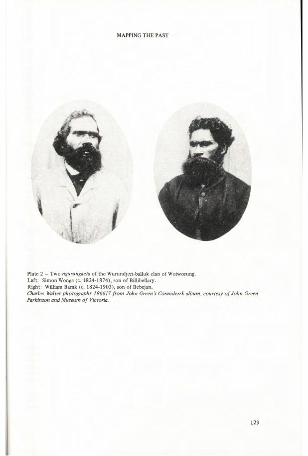
MAPPING THE PAST
Plate 2 - Two ngurungaeta of the Wurundjeri-balluk clan of Woiworung.Left: Simon Wonga (c. 1824-1874), son of Billibellaxy.Right: William Barak (c. 1824-1903), son of Bebejan.Charles Walter photographs 1866/7 from John Green’s Coranderrk album, courtesy o f John Green Parkinson and Museum o f Victoria.
123

ABORIGINAL HISTORY 1984 8:2
(b) tract on N bank of Yarra ‘about Kew’̂ , at Melbourne^, W of Darebin creek to E bank of Saltwater (Maribyrnong) river and Jackson’s creek, N to near Mt William quarry.
Ngurungaeta: BillibelIary^>^/Billbilyeary^/Bil-bil-yer-ry^/Jika Jika/Jacky Jacky/Jakka Jakka/Jaga jagaT,R,H (ca 1799-August 1846), universally identified as a signer of Batman’s treaty. Succeeded 1846 by brother Berberry^/Bearberry^/Barberra^ ‘the man who showed or was said to show Batman the land’̂ /Bar-ber-ry^, ‘his country towards Mt Macedon’ 1839^/Old Jacky^/Mr Bateman^/Old Malcolm^ (ca. 1797-1851+). But in 1847 ‘the would-be chief of Yarra had lately turned a regular drunkard’̂ . His sons Wigeculk^/Wadegulk^/Edward^ (ca. 1821-1846+) and KalkalloT/Kal-kaller^/KulklooT/HenryT (ca. 1824-August 1852, killed by own ‘tribe’ for murder of father’s brother’s son^) had little influence. By 1851 the rightful heir, Billibellary’s eldest son Wonga^/Wongu^’̂ /Simon Wonga (ca. 1824-1874) had married a Wathaurung; he was recognised as ngurungaeta until his death.
(c) tract ‘at Hydleburg’̂ /T, Up Yarra to Mt Bawbaw^, about Yering^-
Ngurungaeta: Bebejan^/Bebejern^/Jerrum Jerrum (n.d. -ca. 1835), whose‘brother’ was identified as Old Jack Weatherly^»^/Old Murry^/Tuat^/Tuart^ (d. Jan. 1849) prominent at Western Port and Yarra ranges through 1840s; heir was son Beruk^/Barak^’̂ /William Barak (c. 1824-August 1903), next in influence to his ‘cousin’Wonga 1851-74, and the sole Woiworung ngurungaeta after Wonga’s death. Howitt’s 1880/2 notes record his decision to name as his successors three younger men who helped him defeat Curr’s scheme to sell Coranderrk: “When I go I shall leave the word that my sister’s son shall be Ngurungaet with him two others’: he named his nephew Wandoon (Robert Wandin 1854-1908); the Taungurong Birdarak (Thomas Bamfield 1839/44-1893); and Thomas Dunolly (1856-1923), spokesman for the Wathaurung and Jajowrong survivors who inherited from their mothers rights to ‘speak for’ Wurundjeri-balluk land.
APPENDIX 2: TA UNGURONG AND NGURAI-ILLAM-WURRUNGThese two -(w)urrung have been loosely labelled ‘Goulburn tribe’ since the 1840s; their dispossession and near extermination by pastoralists who occupied the Campaspe, Goulburn and Broken rivers 1837-41 is documented in archival records only recently publicised by historians. Participants’ reminiscences and discrepant contemporary depositions, together with Aboriginal testimony recorded by Protectors, suggest that large numbers were killed in several reprisal raids led by Col. White, Peter Snodgrass, George Faithfull and other overlanders after the April 1838 ‘Faithfull Massacre’ at the Broken river crossing; in F.M. Mundy’s 1838 attacks on Taungurong and Jajowrong; and in various 1838-41 encounters with clans on the Coliban and Campaspe by squatters C.H. Ebden, W.H. Yaldwyn, Charles Hutton, and Henry Munro (when 18-24 men were shot). Protectorate records for this region are poor; Dredge was only intermittently resident at his Goulburn depot at Mitchellstown (the ‘old crossing place’) August 1839-June 1840; his successor William LeSouefs depot at Murchison 1841-43 was often deserted because of his harsh treatment. Only Robinson and Dr Baylie, at Murchison 1841-43, recorded clan names, and Baylie transposed the location of Taungurong clans 6-9. Baylie’s 1843 guess that 12 named Taungurong, Ngurai-illam- wurrung and Pangerang clans totalled ‘about one thousand’ was quickly corrected: Robinson’s 1843 enumeration of all 11 Pangerang clans totalled only 200; and in 1845 he and Parker counted only 302 survivors of 9 Taungurong and Ngurai-illam-wurrung clans.
While the Protectors’ investigations of squatters’ killings remained inaccessible, researchers necessarily accepted the disingenuous ‘disease’ explanations of Aboriginal mortality offered in Bride’s Letters from Victorian pioneers (Hutton, for example, says the ‘Campaspe tribe’ had ‘suddenly disappeared’ during an influenza epidemic) and elaborated in books by E.M. Curr, occupier of the Heathcote portion of Hutton’s run 1841-43. Curr’s 1883 memoir tells how he acquired pastoral runs stretching from Heathcote to the Murray-Edward junction - the estates of seven clans - but his 1886-87 ‘scientific’ volumes mention only A.A.C. LeSouefs 1877 memories of contact 1841-43 as authority for his inaccurate map of Taungurong/‘Ngooraialum’ territory.
Relying mainly upon Curr’s published vocabularies, modern linguists have defined Bunurong, Woiworung, Taungurong and Ngurai-illam-wurrung speech as one language. The latter two are grouped as a northern dialect. Curr’s vocabulary of the ‘Ngooraialum language’ he had last heard
124

MAPPING THE PAST
spoken ‘thirty-four’ years earlier subsumes Taungurong territory in defining its extent: ‘Seymour to Murchison, part of Goulburn River, Whroo, etc.’ Robinson’s 1845 annual report describing his and Parker’s census of the Goulburn region specifically says ‘There are two dialects in use among the Goulburn natives, the Taoungerong and Taoungbut, some peculiar customs in their social condition in connection with this variation in their language indicates a different origin to the Tribes on the upper parts of the River’. This may mean only that he and Parker perceived that the Taoungbut/ Ngurai-illam-wurrung speech used by clans north of the Taungurong was influenced by the unrelated language of their Pangerang neighbours, or it may indicate the kind of speech differentiation dictated by mythological sanctions which is suggested by Barak’s explanation of Woiworung / Bunurong forms.
Modern linguistic analysis of Tuckfield’s 1842 vocabularies does resolve another ethnographic confusion: his ‘Jhongworrong or Goulburn’ word-list, presumably obtained from Taungurong who guided him from the Murchison depot, belongs to this language, but his ‘Gnurellean . . . West of Campaspee’ vocabulary is classified with Curr’s word-lists from ‘Piangil’ as a dialect of the western Kulin language on the lower Murray. *9 The Gnurellean words came from ‘two tribes’ living up to ‘20 miles’ west of the Murray-Campaspe junction (totalling 130 persons, including 27 women of the ‘Gunn-el-ban tribe’). Tindale’s 1974 description of a ‘Ngurelban tribe’ on the Campaspe merges Tuckfield’s report with Curr’s and Howitt’s descriptions of clans speaking a different language at and east of the Campaspe. A 1902 map of the Murray by a Jajowrong, Sergeant Major**, distinguishes the ‘Wore-yellam’, adjoining the Pangerang on the Goulburn, from the ‘Ngari-lei-an’ occupying the Murray between the ‘Woola-thara’ and the ‘Buraba’. In March-April 1843 Robinson listed and visited the ‘sections’, including Gnorillum and Tongwillum, of a ‘Nat-po-bo nation’ occupying the Murray downstream from the ‘Walledigun’ at the Campaspe-Murray junction to the ‘Gunbower- onedeet’ and other clans of ‘Barappur’ on the Murray and Loddon west of Gunbower. Howitt’s notes do not explain the label ‘Kani Kani’ placed at the Campaspe-Goulbum-Murray junction on Sergeant Major’s map; in 1898 the Cumeroogunga teacher mapped ‘Kyanee’* as neighbours of the Yota-Yota, but R.H. Mathews’ published mentions of the ‘Giani Giani’ give no location.
NGURAI-ILLAM-WURRUNG H— (Nguraiwurung**, Wor-rile-lum**, Woralim®*, Ooraloom®, Ooraialum^6, Ngooraialum^’*"e> Tao-
ungbert®, Taoungbut**, Wore-yallum**, Orilims®, Kani Kani**, Kyanee*, Giani Giani^*)
Description: a -(w)urrung composed of three clans occupying the lower Campaspe and Goulburn rivers between the Taungurong, with whom they shared a common language, and the Wollithiga*- and Kailtheban*- clans about the Murray junction, whose unrelated language was termed Pangerang by Kulin neighbours and European observers in the nineteenth century. The most reliable sources are the 1840-45 reports of Protectorate officials, and descriptions given to Howitt by William Barak, whose mother had belonged to clan 3.
Moiety, clan name, location, clan-head
1. bunjil BENBEDORA-BALLUK (Benbidores®, Boenbedore**, Bane-be-doo-ro**, Benbedor**, Bane-bo-do-ra**, Benebedorro**, Benebedour®, Pimpandoor*-, Brimbudoses**)
Location: S of Wollithiga*" (see Pangerang) at Murray Junction, on both banks of Campaspe to ‘Postlethwaite’s run’ S of Restdown Plains (modern Elmore-Goorngong area where squatter Hutton and Border Police killed 14 in 1839)**’**’ , on Campaspe and Curr’s Coragorag and Colbinabbin runs 1840s*-'; remembered as far E as ‘Mooroopna’ in Barak’s youth**; much reduced by ‘contentions with squatters’ and disease by 1843®; 27 enumerated 1845®’**.
Ngurungaeta: probably Woer-gon-mill/Wore-gon-but/Gine Gine/Mr Clarke**, jailed in October 1840 Lettsom raid when attending Woiworung clan 5 initiation, but no record of trial**.
19 Great Britain 1844: 224-227, 253-255, 279-282; Robinson Papers. I am indebted to R.M.W. Dixon and Jennifer Laycock for information about Tuckfield’s vocabularies.
125

ABORIGINAL HISTORY 1984 8:2
2. waa GUNUNG-YELLAM** (Coningalum®, Connigallum®, Konongillam®)
Location: lower Campaspe between clan 1 and Taungurong clan 4, reduced by violence and disease to 30 by 1843®, 27 enumerated 1845®’®. King Charles Tattambo’s family camped Rushworth, Whroo, Murchison, Molka Station 1860s; grand-daughter who joined Coranderrk in 1872, Mrs Lizzie Eylet Davis (1857/9-1957), identified clan in 1900 as Gunung-yellam** (gunung = creek + dwelling place®*).
Ngurungaeta: Chimbri 1842®; ‘chief of Coningalums’ d. 1842 Murchison depot®’®; King Charles Tattambo d. September 1866 Murchison; son Captain John d. 1874 Murchison.
3. bunjil NOORAIALUM-BALLUK** (Ngurailum**, Ngooralung-boola**, Ngouraylung-bulla**, Ngooraialum^’®"e, Oorilim®e, Ooraialum®-, Wor-ile-lum-buluc®, Woo-ril-lum®, Woo-ral-lim®*, Wo-ra-lims®*, Woralim®, Orilims®)
Location: on Goulburn river N of Mitchellstown, at Murchison, to within 40 miles® (Toolamba®e) of Goulburn-Murray junction®’®*’®, W to ‘creeks’®’®* (Curr’s runs®/), E toward Violet Town and Euroa Vhere they met the Upper Broken River and Ovens Blacks’®e (i.e. Taungurong clan 8 and Waveroo clans to N)®>**. Little contact before visiting Mitchellstown depot February 1840®*, still numerous and healthy except for ‘local diseases of the skin’ at Murchison depot 1841-43®; 53 enumerated 1845®’®.
Ngurungaeta: Weeng-her-bil/Wang-her-bil® in 1840.
TAUNGURONG- (Thagun-wurung**, Tong-worrong®*, Thong-worrong®*’®u, Dareoongrong®, Darngoorong®,
Taoungurong®’®, Tarounwarong®, Jhongwurrong®u, Thaguwurru^*, ‘Goulburn and Devil’s River tribe’®)
Description: a -(w)urrung composed of 9 clans occupying the Broken, Delatite, Goulburn, Coliban and Campaspe watersheds, bounded on the south by the Dividing range; on the east and northeast by Wavoroo clans occupying the Buffalo, King and Ovens rivers; on the north by the related Ngurai- illam-wurrung; and extending west ‘over to Sandhurst [Bendigo] ’** to meet the Jajowrong on the Loddon and its sources.
Moiety, clan name, location, clan-head1. bunjil BUTHERA-BALLUK** (Butherabulluk®*, Butherabulluc®, Butterabulluk®, Budderbul-
locks®, Bootherboolok®’®e)Location: on Goulburn river about Seymour or ‘new crossing-place’**’®’®*’®; dispossessed from 1838 by overlanding pastoralists, notably Col. White whose false complaints® helped provoke October 1840 Lettsom raid when several elders were jailed®; mostly refugees among clan 5 1841- 43®; 26 enumerated in 1845®’®. Falsely reported and mapped as located upstream from Yea®e’®.Ngurungaeta: probably Cor-me-wor-rer-min/Charlie/Mr White®, captured in Lettsom raid, freed before trial®. Unnamed ‘Seymour King’ had sufficient influence to halt April 1844 spear duel when various Wathaurung, Taungurong, Bunurong and Woiworung clansmen related to ‘Warralim’ lad Peter of Echuca punished the young ngurungaeta Lonsdale (Bunurong clan 3) and De Villiers (Woiworung clan 1) for killing him at Western Port in September 1843**’®.
2. waa LEUK-WILLAM** (Lookyellam®*, Lookillum®)Location: ‘near Campaspe, near Kilmore’**; at Mt Alexander initiation January 1840 with clans 3, 4, 5, asked news of named Woiworung and Bunurong clan-heads about Melbourne whom they frequently visited®; visited Mitchellstown depot 1840®*; not listed 1845 enumeration®.
Ngurungaeta: aged Wy-er-ro-loon/Juggy Juggy®, probably the Jacky Jacky who with 2 other leaders forced Grice from Mt Alexander area (a major ceremonial site) in 1841®.
126

MAPPING THE PAST
_ 3. bunjil? MOOMOOMGOONDEET® (Moo-moom-conedeet®, Moo-er-wil-lum®, Moo-ger-re-gon- dee®)
Location: country W of Campaspe, ‘NW’ of Mitchellstown®, Vild men’ from N camped with Learka-bulluk Jajowrong (bunjil moiety) apart from clans 2, 4 (waa moiety) at January 1840 Mt Alexander initiation when 4 shot by Munro®’®; some killed 1839 by Hutton and Border Police®’®; after Grice forced from Mt Alexander 1841, Jajowrong messengers searched ‘NE’ (Bendigo area), reported clan no longer ‘sulky with white men’ and 8 of 15 named survivors joined depot October 1841. Not listed 1845 enumeration of Goulburn district®’®, no record at Loddon after 1842®.
pNgurungaeta: Kerrepn-eninr 184142.
4. waa NATTARAK-BULLUK®* (Nat-ter-ac-bulluc-®, Nitterackbulluk®, Netterackbulluk®, Nattrapbullocks®, Natrakboolok^’̂ e)
Location: Coliban and upper Campaspe®’®, N of Mt Macedon**, W to Mt Alexander®; killed or driven away by Hutton, Munro, Grice 183841®’®’®, survivors with clan 5 or ‘Orilim’ neighbours 184143®; 5 of 20 named joined Jajowrong at Loddon depot November 1841®; 35 enumerated 1845®’**; falsely reported and mapped on Goulburn between Yea and Mitchellstown®'’®"e.
Ngurungaeta: Jille Jille® in 1841; with Jajowrong, aged 50, in 1863.
5. waa NIRA-BALLUK** (Neri-balluk**, Neera-balluk**, Nearabulluk®*, Neenbullocks®, Neer-re- bul-luc®, Neerer-bulluk®, Nerabulluk®, Neribullok*^, Nerboolok®'’*'e, ‘Goulbums’̂ )
Location: (neri, neera = cave or gully**); adjoining Woiworung at Dividing range, on creeks and hills about Kilmore, Broadford, Pyalong, W towards Mt Macedon, N to ‘Dindelong’ creek near Heathcote (Hutton’s run 183840, occupied by Curr 1841)®*’®’**’®’®'e’®'. Ngurungaeta Billy Hamilton prominent at all religious ceremonies organised by Taungurong and Woiworung; at Mt Alexander initiation January 1840**, jailed in Lettsom raid during October 1840 initiation at Melbourne**, jailed February 1843 by Protector LeSouef for threatening language at Murchison depot but immediately released by Protector Parker and several squatters who offered to pay bail as his character was so good®. Clan numerous and ‘peaceable’ 184143®; 74 enumerated in 1845® (probably inflated by some from omitted clans 2, 3).
Ngurungaeta: Yabbee**/Yearba*7ßüly Hamilton®’T’**/King Billy of the Goulburn (d. by 1859); wife Sally and 6 children to Acheron, later to Coranderrk.
6 . bunjil WARING-ILLAM-BALLUK®* (Waring-willum**, Waringillum®*, Warring-yellam®*, Worrinellams*-*, Wurnigullums®, Warringillum**, Warrenillums**, ‘Goulburns’̂ )
Location: upper Goulburn river and its southern sources, adjoining Woiworung clan 4 D,B,H,R. at head of Muddy creek, at Yea and Alexandra**; with clans 8, 9 intermediaries when Mogullumbuk of Buffalo river first visited Woiworung at Melbourne 1845*®’®’**; 14 enumerated in 1845. In 1859 deputation from this and neighbouring Taungurong clans petitioned for land ‘to farm like white men’, selected acreage near Cathedral Hill sacred site but their Acheron reserve soon lost to colonists, moved to Coranderrk 1863.
Ngurungaeta: Bunderboweik*^/Baundaurrong/Bundowrok/01d Man Murry*^/Mr Cotton (c. 1806- 1871). Photographed 1867, believed ‘oldest native in colony’.
7. bunjil YARAN-ILLAM** (Yarranillums®, Yarring Nellams*^, Yeranillum**, Yar-re-nil-lum**, Yare-re-nil-lum**, Yarrerwillums**, Yerra-willum®)
Location: E side of Goulburn ‘below’ Seymour**, at Mitchellstown**, at Aitken’s station, Yea**; probably extended E toward Broken river where Beer-ret met in May 1840®; 1 killed and several jailed in Lettsom raid at Melbourne October 1840, when Robinson learned that ‘Berrut, chief of the Yarrerwillums, killed Waugh’s men’ (in May 1840 attack on new run at Delatite or Devil’s river)®; 22 enumerated in 1845.
127

ABORIGINAL HISTORY 1984 8:2
Ngurungaeta: BerrutR/Beer-ret R /BerretT/BillyR/Dr Billy1 (ca. 1805/16-1865), joined Acheron 1861, Coranderrk 1863, survived by daughter and 2 grandsons.8. bunjil YEERUN-ILLAM-BALLUKH (YeerungillamH, Yirun-illam-balukH, Yarrun-illum-balluk
corrected to Yeerun-illum-ballukH, ‘Maragan tribe’, ‘Devil’s river’7 , Goulburns7)Location: Broken river above and below Benalla^, ‘by swamp below Benalla site of April 1838 ‘Faithfull Massacre’ (see fn 18), locality named ‘Maragan’ in some local histories. Survivors of retaliatory massacres subsequently refugees among clan 9 kinsmen. Baalwick, remembered by Bon family as ‘chief of Broken river tribe’ and ‘chief of Delatite tribe’ took survivors to John Bon’s portion of Hunter and Watson’s Wappan run c. 1844/7; son (named for Bitteruc of clan 9?) led group to Acheron reserve 1861, to Coranderrk 1863.Ngurungaeta-. Baalwick; son Birdarak/Petrark/Bertdrak/Thomas Bamfield/Thomas Mansfield Punch Mickie (1839/44-1893) was named by William Barak as 1 of 3 ngurungaeta to come after him .
9. waa YOWUNG-ILLAM-BALLUKH (Yauung-illam-balukH, Yow-ong-il-lumR, YowenillumR, Yower-nil-lumR, YoungillumB, Yowang-illumP)
Location: (Youang-illum = stone campH, i.e. Howqua river quarry); at Alexandra and upper Goul- burn, at Mansfield^; sources of GoulburnB; met at Mt Battery ‘their country’ May 1840 and Hunter and Watson’s Wappan run, adjoining Mogullumbuk in mountains to ER’ ; 24 enumerated1845.Ngurungaeta-. BitterucR (other name Powerlite/BoyoliteR name for Mt BatteryR) aged 50 in May 1840, 3 sons named; by 1859 MoornalookT/Mor-rer-mal-lokeR/BillR/Mr King/King Billy of the Upper Goulburn (ca. 1806-1867), captured in Lettsom raid October 1840, sentenced to 10 years transportation but escapedR; 1867 photograph labelled ‘once in the hulks for being concerned in a murder, jumped overboard and escaped to Healesville’. Barak identified him as the chief who killed his son Banjam for taking a Wangaratta girl ‘who was like a daughter’; this occurred in a camp ‘near where Ned Kelly’s father had a station’.
* 5jc jfc s|c *
Part 2 of this paper to appear in a later volume will discuss the Wathaurung, Jajowrong, Pangerang and other groups in eastern Victoria.
BIBLIOGRAPHY(Part 1)
Argus [30 letters, 2 leaders, 2 articles on ‘smallpox’] 19 January-19 February 1877.Australian Dictionary o f Biography. Melbourne, vols. 1-8, 1966-81.Barwick, Diane E. ‘Changes in the Aboriginal population of Victoria, 1863-1966’, in D.J. Mulvaney
and J. Golson, eds. Aboriginal man and environment in Australia. Canberra, 1971: 288-315. ______ _ Smallpox in Victoria? Some questions about the evidence. (Seminar paper, History Depart
ment, R.S.S.S., A.N.U., 12 April 1984. MS in author’s possession).Baylie, W.H. ‘On the Aborigines of the Goulburn district’, Port Phillip Magazine, 1, 1843: 86-92. Billis, R.V. and A.S. Kenyon. Pastoral pioneers o f Port Phillip. Melbourne, 1974. (1st published
1932).
128

MAPPING THE PAST
Blaskett, Beverley A. The Aboriginal response to white settlement in the Port Phillip District 1835- 1850. MA Thesis, University of Melbourne, 1979.
Board for the Protection of the Aborigines, Victoria, [titled Central Board . . . 1860-69]. Correspondence, Minutes, Letter-books etc. 1860-1957. Australian Archives, Brighton, Victoria.
Bonwick, James. Port Phillip settlement. London, 1883.Bossence, William H. Murchison. Melbourne, 1965.Bride, T.F. ed. Letters from Victorian pioneers. Melbourne, 1898. >8.Bunce, Daniel. Travels with Dr Leichhardt. Melbourne, 1979. (1st published 1859).Butlin, Noel. Our original aggression. Canberra, 1983.Cannon, Michael ed. Historical records o f Victoria, Volume 2A: The Aborigines o f Port Phillip
1835-1839. Melbourne, 1982._______Historical records o f Victoria, Volume 2B: Aborigines and Protectors 1838-1839. Mel
bourne, 1983.Cary, John J .‘Vocabularies of the Geelong andColac tribes, collected in 1840', Australasian Associa
tion for the Advancement o f Science, 7, 1898: 840-872.[Coranderrk Inquiry]. Report of the Board to enquire into and report upon the present condition
and management of Coranderrk Aboriginal Station, together with the minutes of evidence, Papers Presented to Both Houses o f Parliament, Victoria, Session 1882-83, Vol. 2, No. 5.
Curr, E.M. Recollections o f squatting in Victoria. Melbourne, 1883.________ The Australian race. Melbourne, 1886-87. (4 vols.)Dawson, James. Australian Aborigines. Melbourne, 1881.Dixon, R.M.W. [Review of] ‘Languages of Australia and Tasmania. By S.A. Wurm’, Language, 52
(1), 1976: 260-266._______The languages o f Australia. Cambridge, 1980.Donaldson, Tamsin. ‘Hearing the first Australians’, in Donaldson, Ian and Tamsin Donaldson, eds.
Seeing the first Australians. Sydney, 1985: 76-91.Dredge, James. Journal 1839-1843. La Trobe Library, Melbourne.Eades, Diana Kelloway. The Dharawal and Dhurga languages o f the New South Wales south coast.
Canberra, 1976.Elkin, A.P. ‘R.H. Mathews: his contribution to Aboriginal studies’, Oceania, 46 (1), 1975: 1-24;
46 (2), 1975: 126-152; 46 (3), 1976: 206-234.Fison, Lorimer and A.W. Howitt. Kamilaroi and Kumai. Melbourne, 1880.Great Britain. House of Commons. Aborigines (Australian Colonies). Return to an Address o f the
Hon. the House o f Commons . . . Copies o f extracts from the despatches o f the Governors o f the Australian Colonies. House o f Commons, Sessional Papers, Vol. 34.
Gunson, Niel. The good country: Cranboume Shire. Melbourne, 1968.Haydon, G.H. Five years’ experience in Australia Felix. London, 1846.Hercus, Luise A. The languages o f Victoria: a late survey. Canberra, 1969. (2 vols.)Howitt, A.W. ‘Australian group relations’, Annual Report o f the Smithsonian Institution, 1883:
797-824._______‘On some Australian beliefs’, Journal o f the Anthropological Institute, 13,1883: 185-198._______ ‘On some Australian ceremonies of initiation’, Journal o f the Anthropological Institute,
13, 1884: 432-459._______ ‘On the migrations of the Kurnai ancestors’, Journal o f the Anthropological Institute, 15,
1886: 409-422._______ ‘Further notes on the Australian class systems’, Journal o f the Anthropological Institute,
18, 1888: 30-70._______ ‘Notes on Australian message sticks and messengers’, Journal o f the Anthropological Insti
tute, 18, 1888: 314-332._______ ‘On the organisation of Australian tribes’, Royal Society o f Victoria, Transactions, 1 (2),
1889: 96-137._______ The native tribes o f south-east Australia. London, 1904._______ A.W. Howitt Papers. National Museum of Victoria, and La Trobe Library, Melbourne.
(Photocopies in Australian Institute of Aboriginal Studies Library, Canberra).
129

ABORIGINAL HISTORY 1984 8:2
Howitt, A.W. and Lorimer Fison. ‘From mother-right to father-right’, Journal o f the Anthropological Institute, 12 (1), 1882: 30-46.
_______ ‘Aborigines of Victoria’, in Spencer, Baldwin ed. Handbook o f Melbourne, for . . . Australasian Association for the Advancement o f Science. Melbourne, 1900: 44-56.
Kenyon, A.S. ‘Aboriginal Protectorate of Port Phillip: report of an expedition to the Aboriginal tribes of the western interior by the Chief Protector, George Augustus Robinson’, Victorian Historical Magazine, 12 (3), 1928: 134-171.
Kestevan, S.M. Yota Yota pronouns, Yabula Yabula pronouns and R.H.M. MS, 1975. (In author’s possession, Canberra).
Langhorne, George M. [Recollections, including memoir of Buckley, n.d.] in Cannon, Michael ed. Historical records o f Victoria, Volume 2A. Melbourne, 1982: 176-190.
_______ ‘Suburban native names — origin of Prahran &c’ [letter to G.F. Belcher, October 1889],Argus, 28 April 1906.
Legislative Council, Victoria. Report of the Select Committee on the Aborigines, together with the proceedings of the committee, minutes of evidence and appendices. Votes and Proceedings o f the Legislative Council o f Victoria, Session 1858-59.
Lourandos, Harry. ‘Aboriginal spatial organization and population: south western Victoria reconsidered’, Archaeology and Physical Anthropology in Oceania, 12 (3), 1977: 202-225.
Mackaness, George. ‘George Augustus Robinson’s journey into southeastern Australia, 1844’, Royal Australian Historical Society, Journal and Proceedings, 27 (5), 1941: 318-349.
Mathew, John. Eaglehawk and crow. Melbourne, 1898._______ John Mathew Papers. MS 950, Australian Institute of Aboriginal Studies Library, Canberra.Mathews, R.H. ‘The Victorian Aborigines: their initiation ceremonies and divisional systems’,
American Anthropologist, 11 (11), 1898: 325-343.______ .. ‘Ethnological notes on the Aboriginal tribes of New South Wales and Victoria’, Royal
Society o f New South Wales, Journal and Proceedings, 38, 1904: 203-381._______ R.H. Mathews Papers. Notebooks; Diary transcripts and correspondence, compiled by
A.P. Elkin. Australian Institute of Aboriginal Studies Library, Canberra.Morrison, Edgar. Early days in the Loddon valley. Memoirs o f Edward Stone Parker 1802-1865.
Daylesford, 1967a. (2nd ed.)______ Frontier life in the Loddon Protectorate. Daylesford, 1967b.Mulvaney, D.J. ‘The ascent of Aboriginal man: Howitt as anthropologist’, in Walker, Mary Howitt.
Come wind, come weather. Melbourne, 1971: 285-312.Nance, Beverley. ‘The level of violence: Europeans and Aborigines in Port Phillip, 1835-1850’,
Historical Studies, 19 (77), 1981: 532-552.National Museum of Victoria. C.A. Robinson. [Annual Report 1846.] Appendix H. Brief report of
an expedition to the Aboriginal tribes of the interior over more than two thousand miles of country during the five months commencing March to August, 1846. Typed transcript, National Museum of Victoria. Melbourne, n.d.
Parker, Edward Stone. Periodical reports, censuses, quarterly journals 1840-49. Aboriginal Protectorate Records. Public Record Office of Victoria.
_______The Aborigines o f Australia, a lecture . . . Melbourne, 1854.Parris, H.S. ‘Early Mitchellstown and Nagambie’, Victorian Historical Magazine, 23 (3): 126-160.Presland, Gary ed. Journals o f George Augustus Robinson, January 1840-March 1840. Melbourne,
1977a._______Journals o f George Augustus Robinson March-May 1841. Melbourne, 1977b._______Journals o f G.A. Robinson May to August 1841. Melbourne, 1980.Robinson, G.A. George Augustus Robinson Papers. Journals, letter-books, correspondence, reports.
Vols. 12, 14-31, 54-61, 65,67. Mitchell Library, Sydney._______ Annual Reports. New South Wales Governor’s Despatches 1840-50. Mitchell Library,
Sydney.Royal Commission on the Aborigines, Victoria. Report of the Commissioners appointed to enquire
into the present condition of the Aborigines of this colony.. . together with minutes of evidence and appendices. Papers Presented to Both Houses o f Parliament, Session 1877-78, Vol. 3.
130

MAPPING THE PAST
Serie, Geoffrey. The golden age. Melbourne, 1963.Shanklin, Eugenia and Larry L. Mai. ‘Joseph B. Birdsell: a conceptual biography’, in Mai, Larry L.,
Eugenia Shanklin and Robert W. Sussman eds. The perception o f evolution. Los Angeles, 1981: 21-53.
Sievewright, C.W. C.W. Sievewright Papers. Correspondence, reports 1839-42. Dixson Library, Sydney.
Smyth, R. Brough. The Aborigines o f Victoria. Melbourne, 1878. (2 vols.)Stanner, W.E.H. ‘Aboriginal territorial organisation: estate, range, domain and regime’, Oceania,
36 (1), 1965: 1-26._______After the dreaming (The Boyer Lectures 1968). Sydney, 1969.Stone, A.C. ‘The Aborigines of Lake Boga, Victoria’, Royal Society o f Victoria, Proceedings, 23
(2), 1911: 433-468.Thomas, William. William Thomas Papers, 1838-67. Uncatalogued MSS, Set 214, Items 1-24.
Mitchell Library, Sydney._______ ‘Brief account of the Aborigines of Australia Felix’, ‘Account of the Aborigines’ [1852],
in Bride, T.F. ed. Letters from Victorian pioneers. Melbourne, 1898: 65-107._______ A lexicon of the Australian Aboriginal tongue in the six dialects of Ballarat, Bacchus
Marsh, Melbourne, Gipps Land, Mount Gambier, & Wonnin. 1862. [MS 6290), La Trobe Library, Melbourne.
Tindale, Norman B. ‘Distribution of Australian Aboriginal tribes: a field survey’, Royal Society o f South Australia, Transactions, 64 (1), 1940: 140-231.
_______Aboriginal tribes o f Australia. Berkeley and Canberra, 1974, (2 vols)._______ ‘Reminiscences’, in Mai, Larry L., Eugenia Shanklin and Robert W. Sussman eds. The
perception o f evolution. Los Angeles, 1981: 1-10.Walker, Mary Howitt. Come wind, come weather. Melbourne, 1971.Wurm, Stephen A. and Shiro Hattori. Language atlas Pacific area. Canberra, 1981.
131