18714 staff report -...
TRANSCRIPT

Application No. 18714 Agenda Item No. 7N
Nancy C. Moricz, P.E. 1
Meeting of the Central Valley Flood Protection Board March 23, 2012
Staff Report
California Department of Transportation, District 6 State Route 99 San Joaquin River Crossing, Madera and Fresno Counties
1.0 – ITEM Consider approval of Permit No. 18714 (Attachment B). 2.0 – APPLICANT California Department of Transportation (Caltrans), District 6. 3.0 – LOCATION The project is located north-west of Fresno, between Madera and Fresno Counties, along State Route 99 at the crossing of the San Joaquin River (see Attachment A). 4.0 – DESCRIPTION This project is part of Caltrans plan to widen State Highway Route 99. The applicant proposes to widen Highway 99 at bridge number 41-0008 over the San Joaquin River (the new bridge will be numbered 41-0090). The proposed work will consist of removing the existing four-lane, 877-foot long truss bridge and replacing it with a six-lane cast-in-place, post-tensioned concrete box girder bridge. The bridge will be widened to the west. The demolition of the existing structure and construction of the new bridge will be performed in two stages to allow traffic to use the bridge during construction. The new bridge will be supported by six-foot diameter concrete columns. 5.0 – PROJECT ANALYSIS The overall design of the proposed project, described in Section 4.0, is found to be in compliance with Title 23 standards as described in Sections 5.1 and 5.2 below. The

Application No. 18714 Agenda Item No. 7N
Nancy C. Moricz, P.E. 2
new structure will allow for increased traffic flow through this reach of Highway 99. See Attachment D for proposed Plans. 5.1 – Hydraulic Analysis The model used for the hydraulic analysis was HEC-RAS version 4.0 and was calibrated to the FEMA Floodway Data and Flood Profile. The roughness coefficient of 0.035 was used for both existing and proposed conditions. The analysis included scenarios for a 100-yr event with a design flow of 69,000-cfs based on the September 2008 FEMA Flood Insurance Study. According to the modeling results, there is a maximum rise in Water Surface Elevation (WSE) of 0.04-feet and a maximum decrease in velocity of 0.09-feet-per-second. The changes reflected above are based on the change in bridge design for the replacement and reflect no project changes for vegetation within the extents of the proposed project. The applicant states in a letter signed and stamped by the Civil Engineer preparing the models (see Attachment E), “the channel would be restored to its original state, including vegetation,” and that the “proposed mitigation planting will not change the hydraulic calculations.” Also, within the referenced letter is a request to separate the plantings and bridge project into two permits and that the re-vegetation application will be submitted after the final count of removed species for construction is known. For funding purposes, staff is in agreement with this phased approach. Velocities at the bridge location, for both pre and post project are approximately 8.0-feet-per-second. At the bridge location, there is approximately 22.7-feet of freeboard between the design 100-year WSE and the lowest chord of the proposed bridge (see Attachment C). The new bridge increases the freeboard over the 100-year event by approximately 15.6-feet by removing the existing truss bridge with the proposed post-tensioned concrete box girder bridge. The design takes into consideration scouring due to high flows. The piers are supported by piles that penetrate to a depth well below the scouring effect. The proposed project is in compliance with current Title 23 standards, will result in a substantial improvement to the freeboard at this location, and will improve public infrastructure. For the above stated reasons staff has concluded that the project has no adverse hydraulic impacts on the floodway.

Application No. 18714 Agenda Item No. 7N
Nancy C. Moricz, P.E. 3
5.2 – Geotechnical Analysis Staff reviewed the design plans and concluded that this project does not bear any significant geotechnical impacts on the floodway. All work will be done in a manner that does not pose a threat to the structural integrity of the channel, structures, or floodway. Earthwork will be completed in compliance with Permit No. 18714 (Attachment B) and Title 23 Standards. 6.0 – AGENCY COMMENTS AND ENDORSEMENTS The comments and endorsements associated with this project, from all pertinent agencies are shown below:
• U.S. Army Corps of Engineers (USACE) Non-Federal letter was received on February 13, 2012 stating that the USACE District Engineer had no comments or recommendations regarding flood control because the project does not affect a federally constructed project.
7.0 – CEQA ANALYSIS The Board, as a responsible agency under CEQA, has reviewed Initial Study/Mitigated Negative Declaration (IS/MND) (SCH Number: 2009061047, April 2010) and Mitigation Measures for the Island Park Six-Lane Project prepared by the lead agency, Caltrans District 6. These documents, including project design, may be viewed or downloaded from the Central Valley Flood Protection Board website at http://www.cvfpb.ca.gov/meetings/2012/03-23-2012.cfm under a link for this agenda item. These documents are also available for review in hard copy at the Board and the Caltrans offices. Caltrans determined that the project would not have a significant effect on the environment at on August 11, 2010 and filed a Notice of Determination on August 24, 2010 with the State Clearinghouse. Board staff finds that although the proposed project could have a potentially significant effect on the environment, there will not be a significant effect in this case because revisions in the project have been made by or agreed to by the project proponent. The project proponent has incorporated mandatory mitigation measures into the project plans to avoid identified impacts or to mitigate such impacts to a point where no significant impacts will occur. These mitigation measures are included in the project proponent’s IS/MND and address impacts to aesthetics,

Application No. 18714 Agenda Item No. 7N
Nancy C. Moricz, P.E. 4
biological resources, cultural resources, hazards and hazardous materials, and hydrology and water quality. The description of the mitigation measures are further described in the adopted IS/MND. 8.0 – SECTION 8610.5 CONSIDERATIONS 1. Evidence that the Board admits into its record from any party, State or local public
agency, or nongovernmental organization with expertise in flood or flood plain management: The Board will make its decision based on the evidence in the permit application and attachments, this staff report, and any other evidence presented by any individual or group.
2. The best available science that related to the scientific issues presented by the
executive officer, legal counsel, the Department or other parties that raise credible scientific issues.
The accepted industry standards for the work proposed under this permit as regulated by Title 23 have been applied to the review of this permit.
3. Effects of the decision on the entire State Plan of Flood Control:
This project does not have significant impacts on the State Plan of Flood Control, as the project does not impair the structural or hydraulic functions of the system.
4. Effects of reasonable projected future events, including, but not limited to, changes
in hydrology, climate, and development within the applicable watershed:
There are no foreseeable projected future events that would impact this project. 9.0 – STAFF RECOMMENDATION Staff recommends that the Board adopt the CEQA findings, approve Permit No. 18714, and direct the Executive Officer to take necessary actions to execute the permit and to file a Notice of Determination with the State Clearinghouse.

Application No. 18714 Agenda Item No. 7N
Nancy C. Moricz, P.E. 5
10.0 – LIST OF ATTACHMENTS
A. Location Map B. Draft Permit No. 18714
Exhibit A: USACE Non-Fed Letter C. Hydraulic Summary Table D. General Plan E. Caltrans Vegetation Comment Letter
Design Review: Sergio Guillen, Atkins Consultant Nancy C. Moricz, P.E. Environmental Review: James Herota, E.S. Andrea Mauro, E.S. Document Review: David R. Williams, P.E. – Senior Engineer, WR Eric R. Butler, P.E. – Supervising Engineer, WR

ATTACHMENT A – LOCATION MAP
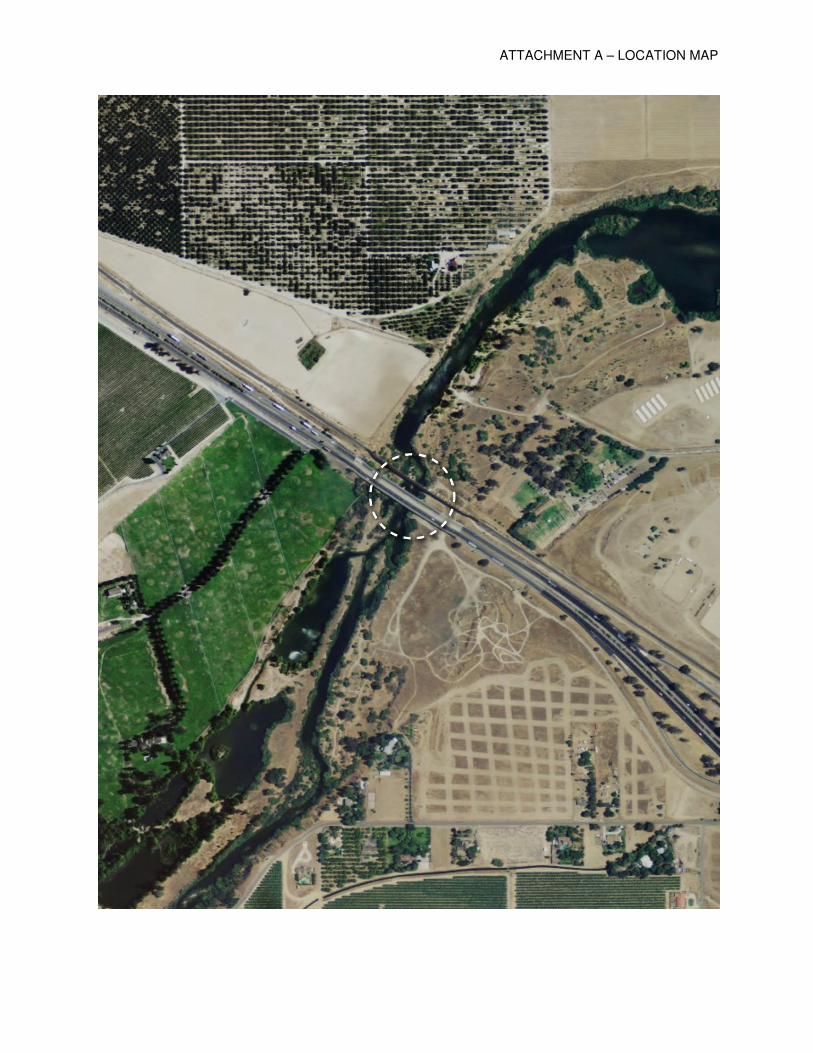
ATTACHMENT A – LOCATION MAP

Page 1 of 5 DWR 3784 (Rev. 9/85)
DRAFT STATE OF CALIFORNIA
THE RESOURCES AGENCY THE CENTRAL VALLEY FLOOD PROTECTION BOARD
PERMIT NO. 18714 BD This Permit is issued to:
Caltrans 2015 E. Shields Avenue Suite 100 Fresno, California 93726
To widen Highway 99 at bridge number 41-0008 over the San Joaquin River (the new bridge will be numbered 41-0090). The proposed work will consist of removing the existing four-lane, 877-foot long truss bridge and replacing it with a six-lane cast-in-place, post-tensioned concrete box girder bridge. The bridge will be widened to the west. The demolition of the existing structure and construction of the new bridge will be performed in two stages to allow traffic to use the bridge during construction. The new bridge will be supported by six-foot diameter concrete columns. This project is located at the State Route 99 crossing of the San Joaquin River, northwest of the city of Fresno. The new bridge will follow the existing alignment and cross the river at the same location. It is located in Caltrans District 6. (Section , T , R , MDB&M, San Joaquin River, Fresno/Madera County).
NOTE: Special Conditions have been incorporated herein which may place limitations on and/or require modification of your proposed project as described above.
(SEAL)
Dated: _________________________ ______________________________________________ Executive Officer
GENERAL CONDITIONS: ONE: This permit is issued under the provisions of Sections 8700 – 8723 of the Water Code. TWO: Only work described in the subject application is authorized hereby.
ATTACHMENT B - Draft Permit No. 18714

Page 2 of 5 DWR 3784 (Rev. 9/85)
THREE: This permit does not grant a right to use or construct works on land owned by the Sacramento and San Joaquin Drainage District or on any other land. FOUR: The approved work shall be accomplished under the direction and supervision of the State Department of Water Resources, and the permittee shall conform to all requirements of the Department and The Central Valley Flood Protection Board. FIVE: Unless the work herein contemplated shall have been commenced within one year after issuance of this permit, the Board reserves the right to change any conditions in this permit as may be consistent with current flood control standards and policies of The Central Valley Flood Protection Board. SIX: This permit shall remain in effect until revoked. In the event any conditions in this permit are not complied with, it may be revoked on 15 days’ notice. SEVEN: It is understood and agreed to by the permittee that the start of any work under this permit shall constitute an acceptance of the conditions in this permit and an agreement to perform work in accordance therewith. EIGHT: This permit does not establish any precedent with respect to any other application received by The Central Valley Flood Protection Board. NINE: The permittee shall, when required by law, secure the written order or consent from all other public agencies having jurisdiction. TEN: The permittee is responsible for all personal liability and property damage which may arise out of failure on the permittee’s part to perform the obligations under this permit. If any claim of liability is made against the State of California, or any departments thereof, the United States of America, a local district or other maintaining agencies and the officers, agents or employees thereof, the permittee shall defend and shall hold each of them harmless from each claim. ELEVEN: The permittee shall exercise reasonable care to operate and maintain any work authorized herein to preclude injury to or damage to any works necessary to any plan of flood control adopted by the Board or the Legislature, or interfere with the successful execution, functioning or operation of any plan of flood control adopted by the Board or the Legislature. TWELVE: Should any of the work not conform to the conditions of this permit, the permittee, upon order of The Central Valley Flood Protection Board, shall in the manner prescribed by the Board be responsible for the cost and expense to remove, alter, relocate, or reconstruct all or any part of the work herein approved. SPECIAL CONDITIONS FOR PERMIT NO. 18714 BD THIRTEEN: All work approved by this permit shall be in accordance with the submitted drawings and specifications except as modified by special permit conditions herein. No further work, other than that approved by this permit, shall be done in the area without prior approval of the Central Valley Flood Protection Board. FOURTEEN: There shall be no plantings within the project area under this permit, except that of native grasses, which may be required for slope protection. FIFTEEN: The permittee is responsible for all liability associated with construction, operation, and maintenance of the permitted facilities and shall defend, indemnify, and hold the Central Valley Flood Protection Board and the State of California; including its agencies, departments, boards, commissions, and their respective officers, agents, employees, successors and assigns (collectively, the "State"), safe and harmless, of and from all claims and damages arising from the project undertaken pursuant to this permit, all to the extent allowed by law. The State expressly reserves the right to supplement or take over its defense, in its sole discretion SIXTEEN: The permittee shall defend, indemnify, and hold the Central Valley Flood Protection Board and the State of California, including its agencies, departments, boards, commissions, and their respective officers, agents, employees, successors and assigns (collectively, the "State"), safe and harmless, of and from all claims and damages related to the Central Valley Flood Protection Board's
ATTACHMENT B - Draft Permit No. 18714
Page 3 of 5 DWR 3784 (Rev. 9/85)
approval of this permit, including but not limited to claims filed pursuant to the California Environmental Quality Act. The State expressly reserves the right to supplement or take over its defense, in its sole discretion. SEVENTEEN: The mitigation measures approved by the CEQA lead agency and the permittee are found in its Mitigation and Monitoring Reporting Program (MMRP) adopted by the CEQA lead agency. The permittee shall implement all such mitigation measures. EIGHTEEN: The Central Valley Flood Protection Board and Department of Water Resources shall not be held liable for damages to the permitted encroachment(s) resulting from releases of water from reservoirs, flood fight, operation, maintenance, inspection, or emergency repair. NINETEEN: No construction work of any kind shall be done during the flood season from November 1 to July 15 without prior approval of the Central Valley Flood Protection Board. TWENTY: The permittee shall maintain the permitted encroachment(s) and the project works within the utilized area in the manner required and as requested by the authorized representative of the Department of Water Resources or any other agency responsible for maintenance. TWENTY-ONE: The permittee shall contact the Department of Water Resources by telephone, (916) 574-0609, and submit the enclosed postcard to schedule a preconstruction conference. Failure to do so at least 10 working days prior to start of work may result in delay of the project. TWENTY-TWO: Temporary staging, formwork, stockpiled material, equipment, and structures shall not remain in the floodway during the flood season from November 1 to July 15. TWENTY-THREE: Prior to start of any demolition and/or construction activities within the floodway, the applicant shall provide the Central Valley Flood Protection Board with two sets of layout plans for any and all temporary, in channel cofferdam(s), gravel work pad(s), work trestle(s), scaffolding, piles, and/or other appurtenances that are to remain in the floodway during the flood season from November 1 through July 15. TWENTY-FOUR: Debris that may accumulate on the permitted encroachment(s) and related facilities shall be cleared off and disposed of outside the floodway after each period of high water. TWENTY-FIVE: All debris generated by this project shall be disposed of outside the floodway. TWENTY-SIX: Cleared trees and brush shall be completely burned or removed from the floodway, and downed trees or brush shall not remain in the floodway during the flood season from November 1 to July 15. TWENTY-SEVEN: Fill material shall be placed only within the area indicated on the approved plans. TWENTY-EIGHT: Backfill material for excavations shall be placed in 4- to 6-inch layers and compacted to at least the density of the adjacent, firm, undisturbed material. TWENTY-NINE: Density tests by a certified materials laboratory will be required to verify compaction of backfill within the regulated channel.
ATTACHMENT B - Draft Permit No. 18714

Page 4 of 5 DWR 3784 (Rev. 9/85)
THIRTY: The soffit of the bridges shall be no lower than that of the existing bridges. THIRTY-ONE: In the event existing revetment on the channel bank or levee slope is disturbed or displaced, it shall be restored to its original condition upon completion of the proposed installation. THIRTY-TWO: The work area shall be restored to the condition that existed prior to start of work. THIRTY-THREE: The permittee shall provide supervision and inspection services acceptable to the Central Valley Flood Protection Board. THIRTY-FOUR: The permittee shall submit as-built drawings to the Department of Water Resources' Flood Project Inspection Section upon completion of the project. THIRTY-FIVE: In the event that levee or bank erosion injurious to the adopted plan of flood control occurs at or adjacent to the permitted encroachment(s), the permittee shall repair the eroded area and propose measures, to be approved by the Central Valley Flood Protection Board, to prevent further erosion. THIRTY-SIX: The permitted encroachment(s) shall not interfere with operation and maintenance of the present or future flood control project. If the permitted encroachment(s) are determined by any agency responsible for operation or maintenance of the flood control project to interfere, the permittee shall be required, at permittee's cost and expense, to modify or remove the permitted encroachment(s) under direction of the Central Valley Flood Protection Board or Department of Water Resources. If the permittee does not comply, the Central Valley Flood Protection Board may modify or remove the encroachment(s) at the permittee's expense. THIRTY-SEVEN: The permittee may be required, at permittee's cost and expense, to remove, alter, relocate, or reconstruct all or any part of the permitted encroachment(s) if removal, alteration, relocation, or reconstruction is necessary as part of or in conjunction with any present or future flood control plan or project or if damaged by any cause. If the permittee does not comply, the Central Valley Flood Protection Board may remove the encroachment(s) at the permittee's expense. THIRTY-EIGHT: If the project, or any portion thereof, is to be abandoned in the future, the permittee or successor shall abandon the project under direction of the Central Valley Flood Protection Board and Department of Water Resources, at the permittee's or successor's cost and expense. THIRTY-NINE: The permittee shall be responsible for securing any necessary permits incidental to habitat manipulation and restoration work completed in the flood control project, and will provide any biological surveying, monitoring, and reporting needed to satisfy those permits. FORTY: The permittee should contact the U.S. Army Corps of Engineers, Sacramento District, Regulatory Branch, 1325 J Street, Sacramento, California 95814, telephone (916) 557-5250, as compliance with Section 10 of the Rivers and Harbors Act and/or Section 404 of the Clean Water Act may be required. FORTY-ONE: The U.S. Army Corps of Engineers District Office has no comments or recommendations regarding flood control because the proposed work does not affect a federally
ATTACHMENT B - Draft Permit No. 18714

Page 5 of 5 DWR 3784 (Rev. 9/85)
constructed project, as stated in their letter dated February 13, 2012, which is attached to this permit as Exhibit A and is incorporated by reference. FORTY-TWO: This permit shall run with the land and all conditions are binding on permittee's successors and assigns.
ATTACHMENT B - Draft Permit No. 18714

ATTACHMENT B: Exhibit A - USACE Non-Fed Letter

ATTACHMENT C – HYDRAULIC SUMMARY TABLE

ATTACHMENT D – GENERAL PLAN

ATTACHMENT D – GENERAL PLAN

ATTACHMENT E – VEGETATION LETTER

ATTACHMENT E – VEGETATION LETTER