2-2 r ep ort on the g re at east jap an e arthq uake n ap r il 9 , the fir st e va c ue e s b e ga n...
TRANSCRIPT

2-2 Report on the Great East Japan Earthquake It has been one month since the Great East Japan Earthquake and subsequent tsunami devastated
the Pacific coast of northeastern Japan. As of April 11, records indicate that the disaster has left
13,116 people dead, 14,377 people missing, and 147,536 people displaced and still living under
difficult conditions in evacuation centers. On April 9, the first evacuees began moving into
temporary housing units, and recovery and rebuilding in the disaster-affected areas is gradually
progressing. The following provides a profile of the earthquake and describes the current state of
recovery based on a field survey conducted from 21-24 March, and on documents published by
various government agencies and the mass media.
(1) Profile of the Earthquake
- Date and Time: 11 March 2011 at 14:46 JST (5:46 GMT)
- Type of earthquake: Plate-boundary thrust-faulting earthquake on or near the Japan Trench
subduction zone
- Hypocenter: 130km off the Pacific coast of the Tohoku region (38°N, 142°E ), 24km depth
- Magnitude: 9.0 (interim value, the largest in Japan)
The areas hit by the Great East Japan Earthquake are known to be vulnerable to tsunamis, as
they have experienced tsunamis in the past. A large inter-plate earthquake had been predicted for
this region, with a 99% probability within 30 years, at magnitudes ranging from M7.5 to M8.0.
However the March 11 earthquake was much larger than predicted, at a magnitude of M9.0 and a
rupture zone measuring 500 km long and 200 km wide. This was the fourth-strongest earthquake
ever recorded in the history of the world. Some experts say that this kind of earthquake and
tsunami occurs only once every thousand years.
c.f. 1960 Chile Earthquake M9.5, 1964 Alaska Earthquake M9.2, 2004 Sumatra Earthquake
M9.2
(2) Damage
The number of casualties continues to rise. The government has confirmed 13,116 fatalities as
a result of this disaster. It has already exceeded that of the 1995 Great Hanshin-Awaji (Kobe)
Earthquake, making it the worst earthquake since World War II. There are 8,017 dead in Miyagi
prefecture alone, accounting for more than half of the death toll. The number of people who are
missing covers only those who have been reported to the police by their families or
acquaintances.
The number of evacuees once topped 300,000, but it has been falling as the situation has
stabilized and services and utilities have gradually been restored. The number of casualties in
major cities and towns is indicated in the table below. There have been more than 1,000
confirmed fatalities in the cities of Rikuzen-Takata and Ishinomaki. There are more than 10,000
6

evacuees in the cities of Rikuzen-Takata, Kesennuma, and Ishinomaki. The ratio of evacuees is
about 50% in Rikuzen-Takata city and Minami-Sanriku town, indicative of the complete
devastation experienced in these municipalities. The ratio of evacuees is more than 20% in the
towns of Yamada, Otsuchi, and town.
Prefecture Dead Missing Evacuees
Iwate 3,811 4,721 45,319
Miyagi 8,017 6,416 53,468
Fukushima 1,226 3,236 25,663
Others 62 4 23,086
Total 13,116 14,377 147,536
Casualties by Prefecture (as of April 11)
On the other hand, the value of the destruction of the social infrastructure, housing, and
corporate facilities is estimated at between 16 and 25 trillion yen (Cabinet Office). Most of the
prefectures that were most severely affected depend largely on the agricultural and marine
product industries. These key industries were badly damaged. The total damage to farmlands,
agricultural facilities, and agricultural produce is estimated at 520 billion yen. The rebuilding of
farmlands is likely to be particularly problematic, since those lands will have suffered salt damage.
As for the fishing industry, 19,000 fishing boats were damaged, and the total damage to the
industry, including boats and facilities, is valued at 350 billion yen. Rebuilding these industrial
bases is of supreme importance for the local economy and job security.
(3) Disaster-Affected Areas
Several disaster-affected areas in Miyagi prefecture were surveyed in March; their situations
are outlined below.
1)Wakabayashi Ward, Sendai City
Wakabayashi ward is located in the coastal area of Sendai city, and was one of the areas
more severely hit by this earthquake. This area has no historical record of any large tsunamis,
and local hazard maps were designed around a maximum tsunami wave height of 3m. In reality,
however, a much larger tsunami hit the area. A belt of windbreak forests had been built along
the seacoast as a preparedness measure, and the elementary schools had been designated as
evacuation sites since there are no hills in the area.
7
2. Highlights of 2011/2012
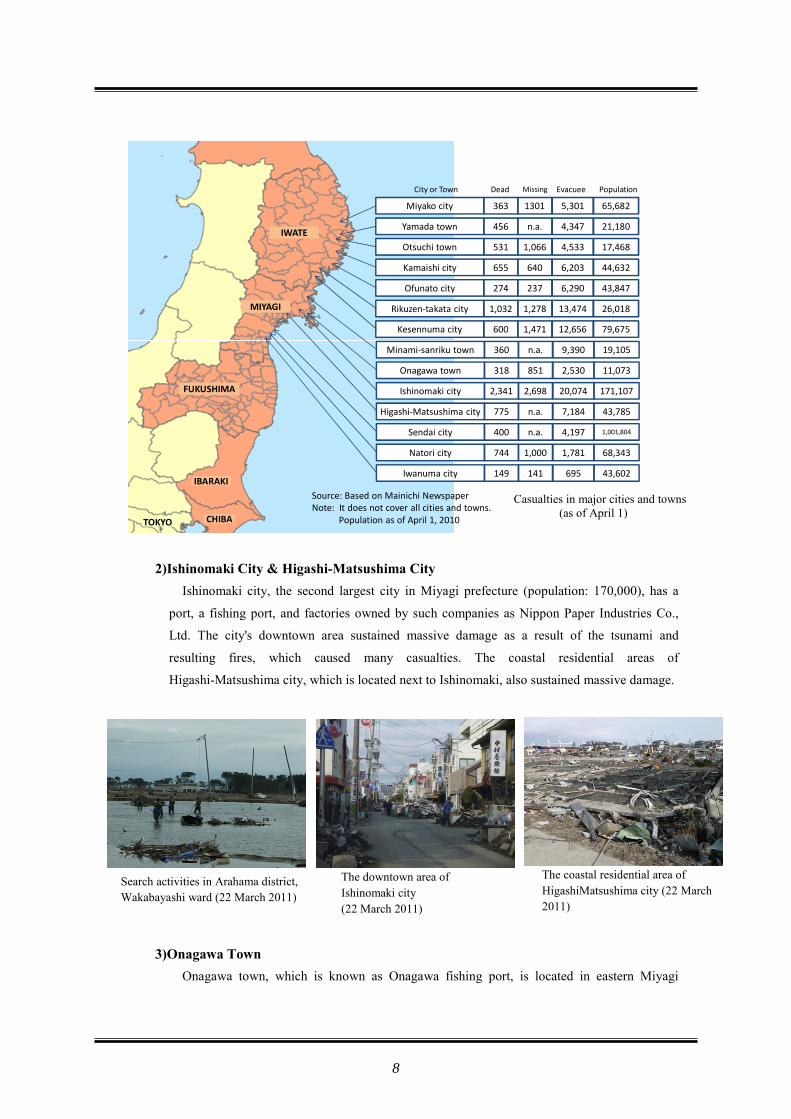
2)Ishinomaki City & Higashi-Matsushima City
Ishinomaki city, the second largest city in Miyagi prefecture (population: 170,000), has a
port, a fishing port, and factories owned by such companies as Nippon Paper Industries Co.,
Ltd. The city's downtown area sustained massive damage as a result of the tsunami and
resulting fires, which caused many casualties. The coastal residential areas of
Higashi-Matsushima city, which is located next to Ishinomaki, also sustained massive damage.
3)Onagawa Town Onagawa town, which is known as Onagawa fishing port, is located in eastern Miyagi
Source: Based on Mainichi NewspaperNote: It does not cover all cities and towns.
Population as of April 1, 2010
City or Town Dead Missing Evacuee
65,682Miyako city 363 1301 5,301
Population
Yamada town 456 n.a. 4,347 21,180
Otsuchi town 531 1,066 4,533 17,468
Kamaishi city 655 640 6,203 44,632
Ofunato city 274 237 6,290 43,847
Rikuzen-takata city 1,032 1,278 13,474 26,018
Kesennuma city 600 1,471 12,656 79,675
Minami-sanriku town 360 n.a. 9,390 19,105
Onagawa town 318 851 2,530 11,073
Ishinomaki city 2,341 2,698 20,074 171,107
Higashi-Matsushima city 775 n.a. 7,184 43,785
Sendai city 400 n.a. 4,197 1,001,804
Natori city 744 1,000 1,781 68,343
Iwanuma city 149 141 695 43,602
CHIBA
IBARAKI
FUKUSHIMA
MIYAGI
IWATE
TOKYO
Search activities in Arahama district, Wakabayashi ward (22 March 2011)
The downtown area of Ishinomaki city (22 March 2011)
The coastal residential area of HigashiMatsushima city (22 March 2011)
Casualties in major cities and towns (as of April 1)
8

prefecture. Onagawa's downtown area was totally destroyed by the tsunami. Along the coast,
wooden houses were carried away, leaving only their foundations, and even reinforced concrete
buildings collapsed. The Onagawa town office is reported to have been inundated to the roof. A
hill just behind the fishing port was designated as an evacuation area. Traces of water were
found inside a hospital located on top of this hill,
indicating that even that area, which is nearly 16 meters high, was not out of reach of this
tsunami.
4)Minami-Sanriku Town
Minami-Sanriku town is located in northeastern Miyagi prefecture facing the Pacific Ocean.
The tsunami washed away most of the buildings in the downtown area, completely devastating
the town. At Shizugawa Hospital located near the coast (some 200 meters inland), there were
indications that the tsunami had reached the 5th floor. In an apartment building near the
seashore, which had been designated as a tsunami evacuation building, there were traces of
water indicating that the tsunami had reached the 4th floor.
The disaster management center of Minami-Sanriku, a threestory building, was designed to
function as a tsunami evacuation building. When the tsunami struck, about 30 municipal
officials evacuated to the rooftop, but only 10 survived. A young official who kept delivering
evacuation notices to the villagers until the very last moment has yet to be found. It was
generally believed that three-story reinforced concrete buildings could be designated as
evacuation buildings, but such structures provided insufficient protection during this disaster.
Panoramic view of Minami-Sanriku (2011.3.23)
Disaster management center of Minami-Sanriku (2011.3.23)
The coastal area of downtown Onagawa (2011.3.22)
The evacuation route to Onagawa Municipal Hospital (2011.3.22)
9
2. Highlights of 2011/2012

(4) Effectiveness of Pre-Tsunami Disaster Preparedness Measures The Pacific coastal areas of Iwate prefecture and the northern part of Miyagi prefecture
(Sanriku Coast) are known to be vulnerable to tsunamis, as they had been devastated by the
tsunamis that occurred following the 1896 Meiji-Sanriku earthquake, the 1933 Showa-Sanriku
earthquake, and the 1960 Chile earthquake. Various measures, both structural and non-structural,
had been taken in those areas to protect
people and communities from tsunamis. The most notable were the construction of a 10 m high
and 2.5 km long dyke in the Taro area of Miyako city, often called “the Great Wall,” and the
construction of the world's largest breakwater (8 m above sea level, and 63 m deep) in Kamaishi
city. The structural measures must have reduced the impact of the tsunami, but were found to be
insufficient to protect people’s lives in this case.
Non-structural measures complement structural measures. The media has reported that
measures such as preparedness education and lessons learned from past disasters helped people
escape from the tsunami, as indicated in the following cases. The preparedness education
conducted before the tsunami enabled the pupils at primary and junior high schools in Ishinomaki
city (one of the most severely damaged cities) to successfully escape the tsunami. The Mizuhama
area of Ishinomaki city, which is comprised of 130 households, was completely destroyed by the
tsunami.
However, only one person died and eight people were reported missing out of the total
population of 380 residents. This shows that the residents' knowledge of what to do in an
earthquake and their performance of regular exercises and drills helped them survive.
Nearly 150,000 displaced people are staying at evacuation centers, such as community centers,
schools, and sports stadiums. This figure does not cover those who are staying in their homes,
cars, or other locations under harsh living conditions. Since the provision of temporary shelters
will take many months and the sanitation conditions at the evacuation centers continue to
deteriorate, some local authorities, such as Minami-Sanriku town, have started to temporarily
relocate some evacuees to other places with better living conditions, such as hotels and public
apartments in less affected areas.
Earthquake Date Magnitude Epicenter Killed / Missing
Height of Tsunami (Max)
Meiji-Sanriku June 15 1896 8.2 Off Iwate 21,959 38.2 m
Showa-Sanriku March 3 1933 8.1 Off Iwate 3,064 29.3 m
Chile May 22 1960 9.5
Off Chile in South America
142 5.6 m
Major Earthquakes Affecting the Tohoku Region
10

1) Temporary Housing On March 14, MLIT asked the Japan Federation of Housing Organizations to construct
30,000 temporary housing units in two months. The construction started in Rikuzen-Takata,
Iwate prefecture on March 19, and the transition of residents into those homes started on April
9. Similar construction efforts have also been launched in other cities and towns, and as of
April 11, 7,454 temporary housing units were being constructed at 78 sites. Considering the
high demand, the prefectures have increased the number of required temporary housing units.
MLIT has therefore asked the housing companies to construct another 30,000 units, in addition
to the 30,000 units requested in March.
2) Removal of Debris
The tsunami created a huge amount of debris from collapsed structures, washed away cars,
boats, and other materials, and these have been scattered throughout the tsunami-hit areas.
Debris is still blocking roads and streets. The estimated amount of debris in Miyagi prefecture
alone is between 15 and 18 million tons -equivalent to 23 years of waste generated under
ordinary circumstances. Moreover, there is a growing
concern that the debris could be harmful to human health and the environment as
temperatures start to rise and the rainy season begins in June. The cleanup and disposal of
debris is complicated by the need to consider many different elements, including cars, boats,
toxic waste, and items of personal value.
3)Bills, Supplementary Budget, and Other Efforts
A Reconstruction Plan Committee was established on April 11 to serve as an advisory body
to the national government. The government is now preparing some other bills, which propose
various policy measures and necessary mechanisms for full-fledged recovery and
reconstruction, which are to be submitted to the Diet (Japanese parliament). The proposals
include the establishment of new institutions to be responsible for the implementation of
recovery and reconstruction.
The government is also preparing supplementary budget proposals for deliberation in the
Diet, which are reported to propose the allocation of more than 10 trillion yen to
disaster-related efforts. It is also reported that the government is examining a plan to relocate
residents of tsunami-hit areas to higher ground, where
new communities can be built, and to purchase the areas
totally devastated by the tsunami, since these will not be
suitable for the rebuilding of communities.
Evacuation center in Minami-Sanriku (2011.3.23)
11
2. Highlights of 2011/2012