2. flood hazard assessment - city of...
TRANSCRIPT

City of Petaluma Floodplain Management Plan 4 October 4, 2010
2. Flood Hazard Assessment
2.1 Community Background
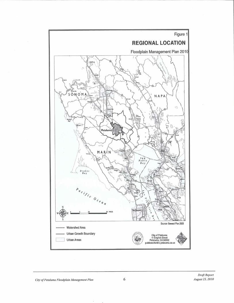
Incorporated in 1858, the City of Petaluma is situated in southern Sonoma County, in northern California, northwest of San Pablo Bay (Figure 1). San Francisco is 35 miles to the southeast. Petaluma occupies an area of 13.6 square miles along U.S. Highway 101 (City of Petaluma GIS Data, 2010). According to the 2010 census, the current population of Petaluma is 58,401.
The Petaluma Valley is a relatively flat alluvial plain developed by overlapping and coalescing alluvial fans derived from the erosion of volcanic rocks in the bordering highlands. This alluvium is comprised of clays, silts, and floodplain sediments, with minor layers of sand and pebble gravels. The elevation ranges from sea level (National Geodetic Vertical Datum of 1929) at the Petaluma River to over 400 ft. in the surrounding hills. The valley enjoys a Mediterranean type of climate, characterized by long, dry summers and cool, wet winters. Temperatures remain moderate throughout the summer and seldom drop below 22 degrees Fahrenheit in the winter. The average annual precipitation over the basin is estimated at 26 inches (City’s Consulting Meteorologist, Jim Goodridge).
Development in the urban area consists of residential subdivisions, office complexes, small businesses, schools, shopping centers parks and open space. Through the years, growth has resulted in encroachment upon many segments of the waterways in the urban area. A typical waterway courses through a combination of natural and improved sections, with bridges and culverts located at frequent intervals. Buildings and homes have been built along the banks, often limiting the flood-carrying capacity (FEMA, 1989).
Petaluma is now in the final stages of a multi-million dollar Flood Control Project undertaken in partnership with the Army Corps of Engineers. Although the project has been marked with delays in funding and cost increases, it is scheduled for completion in summer of 2011, pending congressional funding for the last phase of improvement. The Flood Control Project will be outlined in more detail later in this report. Once completed, it will effectively eliminate the repetitive loss zone within the Payran reach of the City, and will provide 100-year flood protection to this neighborhood.

City of Petaluma Floodplain Management Plan 5 October 4, 2010
In May of 2008, the City Council adopted a new General Plan. The General Plan contains several policies aimed at improving floodplain management within the City of Petaluma and its watershed. These policies will be described in more detail throughout this FMP. General Plan chapters 4, “the Natural Environment”, and 8, “Water Resources” have been included in the FMP appendix A and B.
2.2 History of Flooding
In the mid-1800's storm water runoff from the Petaluma watershed, which drained to the Petaluma River and its tributaries, often overtopped the existing channels and spread across the valley until it could return to the waterways and complete its flow to San Pablo Bay. In the ensuing century, with settlement of the town of Petaluma and the surrounding areas, and the urbanization of the region since the 1950's, such overflow could no longer be tolerated. Measures were implemented to improve drainage and control the flooding -- flood control projects were constructed, standards were adopted for private development, and floodplain zoning was instituted. All of these helped to solve many of the problems but, as was most dramatically evident during the storms of January 1982, February 1986 and most recently December 2005, many problems still existed. The most serious of these is the flooding that occurs along the Petaluma River itself. This waterway, which once meandered across the valley, now flows through the most heavily urbanized area of the City of Petaluma and causes significant damage and disruption when storm runoff from its tributary area exceeds its capacity.
The largest flood of record in the City of Petaluma occurred during the period of January 3-5, 1982, and caused an estimated 28 million dollars in damages. The flood is documented in an Army Corps of Engineers post-flood report. An excerpt of this report read:
"During the January 1982 storm, flooding occurred over a 50+ block area on both sides of the river through the City of Petaluma. Most of the 500 homes and the 100 commercial-industrial establishments in this area incurred flood damage. In many cases, water depth reached two to three feet inside the structure. The most severely hit area appears to be along Jess Avenue where most homes had four to five feet inside. Payran Street was also an area of major damage in which flooding reached over three feet inside the structure."
City of Petaluma Floodplain Management Plan 7 October 4, 2010
Approximately one million dollars in flood damages occurred in the urbanized reach of the Petaluma River between the Lynch Creek confluence and the Lakeville Street Bridge during the flood of February 14-17, 1986. On February 15, an article in the San Francisco Chronicle was headlined "Petaluma Takes to the Boats":
"Yesterday, most of the townsfolk put their experience to use and took their lumps like troupers. The relatively few newcomers in the hardest-hit Linda Del Mar subdivision, where the water depth in the street reached five feet, "absolutely panicked," according to a veteran of the 1982 deluge."
At 4 a.m., a flood alert was posted for the city of 40,000 people. By dawn, a team of police officers, firefighters and volunteers was knocking on doors in Petaluma's flood prone flatlands.
About 400 homes were evacuated in the Linda Del Mar subdivision and several trailer parks west and east of U.S.101. Those who could not drive over the flooded roads were removed by bus and, later, by boat.
On March 9, 1995, Petaluma once again experienced significant flooding. This flooding resulted in approximately nine thousand dollars of damage to the Petaluma Wastewater Treatment plant when fencing and levees around an aerated lagoon were damaged. There was additional damage to Hopper Street, as well as increased need for electricity usage and monitoring. Seven schools in Petaluma were closed, and a total of 327 homes evacuated, although none were inundated. On March 10, 1995 an article in the San Francisco Chronicle titled “Soggy Anger on the Street That Always Floods” reads:
“This same area (Payran Street) has flooded over and over since the big flood of 1982. Yesterday was no exception with about 3.5 inches of rain pounding Petaluma during the 24 hours ending at noon. By 7:30 a.m., the raging waters were overflowing the Payran Street Bridge, sweeping over yards, into some garages and basements and forcing emergency workers to order the evacuation of 193 homes of Payran, Jess Avenue and Rocca Drive.”
“Another 134 residences were evacuated at the Leisure Lake Mobile Home Park, where Willow Creek was threatening to overflow its banks and turn the park into an island. By 5 p.m. the waters were dropping, and most residents were allowed to return to their homes.
In the winter of 1997-1998 the effects of El Nino storms were felt throughout California and the rest of the country. Some large storms hit the West Coast in the first three weeks of February 1998, and these caused flooding in Petaluma as well as in many other parts of the state. The cost of damages in Petaluma was nearly six million dollars. Most of the damage occurred during the flooding on February 2-3, 1998, with some recurring damage

City of Petaluma Floodplain Management Plan 8 October 4, 2010
from another storm on February 29, 1998. State and Federal governments declared the winter storms and flooding a disaster, and FEMA designated the event as “FEMA – 1203 – DR”. The greatest damage was to the homes in the Payran area and businesses in the Industrial Avenue/Auto Center Drive area. The oxidation ponds at the City of Petaluma’s wastewater treatment facility were damaged once again. Considerable silt buildup in the Turning Basin required dredging, and many roads in the City suffered damages. On February 20, 1998 in an article titled “More Rain, More Havoc” the San Francisco Chronicle reported:
“A flash flood caused the Petaluma River to jump its banks and spill into the streets and homes of the hard-hit Payran area of Petaluma. It was the third time in three weeks that the low-lying community has been flooded. Nearly 50 homes were evacuated and cars parked by the river were nearly submerged. Petaluma firefighters used an inflatable boat to rescue a few stragglers. Others waded out of the neighborhood through streets that had as much as three feet of water.
“Meanwhile, nearly 30 seniors were evacuated from the Leisure Lake mobile home park north of Petaluma when Stony Point Road flooded, cutting off automobile access to the community.”
Most recently, on December 31, 2005, the City again experienced significant flooding, particularily in the middle and northern areas of town. It is estimated that approximately 53 structures, not including mobile home parks, were damaged by flood waters at an approximate cost of $56,000,000. There was also damage to local streets and river channel banks as a result of the flooding. The greatest damage from this event was located within the Petaluma Factory Outlets, commercial structures and three of the City’s mobile home parks. The Payran reach was not adversely affected by this flood, which is mainly attributable to a majority of the Petaluma River Flood Control Project being in place. The flooding event was declared a State and Federal disaster.
On December 29, 2006, the Press Democrat published the following excerpt from a year in review article:
“The New Year's Eve flood was the biggest news story of the year. The flooding - the most severe since 1997 - caused $56 million in damage, most of it in north Petaluma. In some cases, it took property owners months to recover. Hardest hit were businesses near the Petaluma River, including the auto mall, where hundreds of cars were damaged, and the outlet mall, where 1 to 2 feet of muddy water poured into many shops.”

City of Petaluma Floodplain Management Plan 9 October 4, 2010
(Aerial view of Factory Outlet Mall flooding, 12/31/05)
2.3 Designated Floodplains and Flood Data
Approximately 1880 acres of the City of Petaluma lie within the FEMA designated 100-year Special Flood Hazard Area (SFHA), shown in Figure 2. In addition, 112 acres of this area are a designated floodway.
In December of 2008, under the map modernization act, FEMA issued updated flood insurance rate maps known as D-FIRMS. The D-FIRMS are very similar to the 1989 FIRM’s for Petaluma and are essentially an electronic version of the 1989 FIRM data. The D-FIRMS also include new information that the 1989 maps did not include such as aerial photography. The data is helpful in better determining floodplain locations. The D-FIRMS do not include revised floodplain boundaries based on post 1989 development and structural flood control projects. However, the City of Petaluma is currently in the application process with FEMA staff on the updated watershed wide hydraulic and hydrologic data, which will be used to modify the current D-FIRMS. Based on the remaining flood control project schedule and status of the remapping effort, it is anticipated that new D-FIRMS will be issued by FEMA in less than two years.
In addition to the FEMA FIRM maps, the City of Petaluma created and adopted “Figure 8.1, 100-year Flood Boundary General Plan 2005 build out.” The exhibit with its defined

City of Petaluma Floodplain Management Plan 10 October 4, 2010
boundary was created to identify limits of the New Year’s Eve 2005 flood event and develop policies within the General Plan 2025 that require new development to comply with higher regulatory standards than those defined by FEMA. The limits of this floodplain boundary were determined by a post flood aerial and ground high water mark/debris line survey.
Historically, there are two main areas of significant flooding along the Petaluma River. The first area, lying between Denman Flat and the confluence of the Petaluma River with Lynch Creek, consists mainly of commercial, industrial, retail and undeveloped properties. The second area, located between the Lynch Creek/Petaluma River confluence and the Lakeville Street Bridge, consists mainly of residential properties developed during the 1960’s. This residential area is referred to as the Payran reach Floodplain. Significant flooding can occur in the urbanized "Payran Reach" between the Lynch Creek confluence and the Lakeville Street Bridge. However, as of October of 2010, over 90% of the Petaluma River flood control project has been constructed. The project consists primarily of a trapezoidal channel with steel sheet pile walls along the Payran Area of the Petaluma River. The flood control project was designed flood protection in the Payran Area for the 100-year event. The Payran Area did not flood during the December 31, 2005 event. Most of the City has been mapped as AE areas, with determined base flood elevations. There are also two areas mapped as zones AO, which indicates sheet flow on sloping terrain. One area in the City has been classified as Zone AH, which represents an area of ponding. The floodplain area from Denman Flats to Lynch Creek consists of all three of these Zones, while the Payran Area Floodplain is fully zoned AE. The average depth in both Zones AO and AH is one to three feet:
1) AO - East of Rt. 101, bounded by Old Redwood Highway and Corona Creek; 2) AO - Slightly North along US 101 from the Old Redwood Highway
intersection; 3) AH – Northwest of Capri Creek between US 101 and McDowell Blvd. North.
Characteristic floods in the Petaluma River Basin are normally of short duration, lasting a few hours to one or two days. Floods on the Petaluma River may develop within hours after the beginning of a flood-producing storm and begin to recede within hours of the end of the storm. Although floods have been recorded as early as November and as late as April, most occur between December and February after prolonged rainy periods, which fully saturate the soil, increasing runoff volume. Flooding can occur along the entire length of the River.

City of Petaluma Floodplain Management Plan 11 October 4, 2010
The natural storage area of Denman Flat in the northwestern part of the City, where Willow Brook, Liberty, Marin and Wiggins Creeks come together to form the Petaluma River, acts as a detention basin and helps to reduce downstream peak discharges. Significant flooding occurs in this natural storage area and to the area east of Denman flat between Highway 101 and the Northwestern Pacific railroad line when excess flows in the Willow Brook channel escape as sheet flow to the southwest.
Flooding from the Petaluma River can occur in the reach between Denman Flat and the confluence with Lynch Creek, and is generally shallow. Flooding is reduced in depth downstream of Lakeville Street and is fairly well contained in the Petaluma River channel below the "D" Street Bridge.

City of Petaluma Floodplain Management Plan 12 October 4, 2010
Figure 2

City of Petaluma Floodplain Management Plan 13 October 4, 2010
2.4 Petaluma Benefit Assessment Zone 2A
In 1959, the Petaluma Benefit Assessment Zone 2A was created as a joint flood control endeavor between the City of Petaluma and Sonoma County Water Agency. This zone encompasses 87 square miles bounded by San Antonio Creek on the south; Browns Lane and Stage Gulch Road on the southeast; Railroad Avenue, Roberts Road, and Lichau Road on the North; and Laguna Road, Lake Street and Two Rock Road on the west. In general, the zone includes all tributary drainage reaching the Petaluma River north of the mouth of San Antonio Creek. Residents within this Zone pay an extra tax to fund structural projects that will reduce flooding risks in this area. There is a seven-member Zone 2A Advisory Committee consisting of citizens who reside within the Zone and representatives from the City of Petaluma and Sonoma County. This committee is responsible for recommending budget priorities to the Board of Directors of the SCWA for inclusion in the Zone budget for each fiscal year.
2.5 Petaluma Watershed Master Drainage Plan
As a result of the major flooding that occurred in 1982 and 1983, the City of Petaluma requested, and the Flood Control Zone 2A Advisory Committee recommended, that the Sonoma County Water Agency prepare a Drainage Master Plan for the Petaluma River Watershed. The plan was completed in March of 1986. Petaluma adopted the Master Drainage Plan as policy under Program 7 of the Community Health and Safety Element of the City’s former General Plan (1987-2005), which stated:
Program 7 - Adopt the most reasonable, sensitive, and effective proposal(s) of the Sonoma County Water Agency Master Drainage Plan in order to mitigate the 100-year flood.
The Master Drainage Plan is used by the Sonoma County Water Agency and the City of Petaluma in their capital improvement planning and construction, and in review and approval of land developments. It provides a valuable tool for consulting engineers by alerting them to the approximate scope of the drainage improvements needed for land development. The Master Plan is used by the Flood Control Zone 2A Advisory Committee to select projects for construction using SCWA funds. On a daily basis, the Master Drainage Plan is used by the SCWA and the City for resource information to respond to questions from the public. The Master Plan has three basic elements.

City of Petaluma Floodplain Management Plan 14 October 4, 2010
1. The watershed is described as to size, location, land use and other significant information.
2. The flooding and drainage problems of the watershed are described. 3. Structural solutions are described; including anticipated changed conditions or
environmental effects.
The report includes maps to identify the area studied and also the flood hazard and drainage problem areas; as well as drawings to show the location, size and type of drainage improvements, which, if constructed, would alleviate or eliminate the problem.
The Sonoma County Water Agency updated the Petaluma River Watershed Master Drainage Plan in June of 2003. The City of Petaluma continues to work with the Sonoma County Water Agency and Zone 2A committee on implementing various projects identified in the master plan. Policy 8-9-29 of the City’s General Plan 2025 acknowledges the updated master plan and contains policies and programs to work with Sonoma County Water Agency and County of Sonoma staff to implement projects from the 2003 master plan. A copy of the Petaluma River Watershed Master Drainage Plan is available for public review at the City of Petaluma.
2.6 Phase II NPDES Storm Water Management Plan
In November of 2003, the City of Petaluma adopted a Storm Water Management Plan (SWMP) per the mandated requirements of the Federal Clean Water Act. The plan identifies the following six minimum control measures that the City must undertake to improve storm water quality:
• Public Education and Outreach • Public Participation and Involvement • Illicit Discharge Detection and Elimination • Construction Site Storm Water Runoff Control • Post-Construction Storm Water Management • Pollution Prevention for Municipal Operations
The SWMP identifies programs and projects aimed at minimizing accelerated erosion and the amount of sediment laden runoff from entering the Petaluma River. A new storm water ordinance (Chapter 15.80 of the City’s Municipal Code) was adopted as part of the SWMP requirements in June of 2005. An update of the SWMP is anticipated in 2011.

City of Petaluma Floodplain Management Plan 15 October 4, 2010
2.7 Seismic and Geologic Hazards
Two active faults affect the Petaluma area: the San Andreas Fault and the Healdsburg-Rodgers Creek Fault. Based on a fault evaluation report conducted by the California Division of Mines and Geology, the Tolay Fault zone was removed from the special studies zone designation. Subsequently, the City removed the Hazard Management Zone for the Tolay Fault. Nevertheless, the City’s Building Division staff maintains that site-specific geotechnical field studies should be required for proposed developments on or in the immediate vicinity of the Tolay Fault.