2. study reports and supporting documents
TRANSCRIPT

GTA West Corridor Planning and Environmental Assessment Study
Draft Transportation Development Strategy Report
February 2011- Draft 31
2. STUDY REPORTS AND SUPPORTING DOCUMENTS
2.1. OVERVIEW
Throughout the GTA West Corridor Planning and Environmental Assessment Study, interim reports have been prepared to record critical steps in the study process, including: documentation of existing environmental, transportation and economic conditions; methodology and identification of future transportation problems and opportunities; identification of development issues and corridor protection needs; and methodology, development and assessment of alternatives to address the identified problems and opportunities. The work recorded in these interim reports has shaped the development of the GTA West Transportation Development Strategy (TDS). Key content of each of these reports have been presented to the public and stakeholders at Public Information Centres and meetings, and the draft reports are available on the study website (www.gta-west.com). A summary of each report is provided below, highlighting the reports’ timing and role in the study, and key elements.
2.2. OVERVIEW OF TRANSPORTATION AND ECONOMIC CONDITIONS REPORT
2.2.1. Report Overview
The Overview of Transportation and Economic Conditions Report was published as a Draft for Consultation in July 2008. This report established baseline transportation and socio-economic data for the purpose of undertaking the Environmental Assessment Study. The report focused on documentation of historical transportation and socio-economic conditions and trends in the preliminary study area. The review of historical trends was applied to existing conditions as part of an investigation of the “Area Transportation System” needs, providing a foundation for the generation and evaluation of transportation alternatives to address future problems and opportunities, and ultimately development of the multi-modal development strategy. The draft report included an overview of relevant federal, provincial and municipal policies, a definition and description of the “Area Transportation System”, a description of current travel conditions in the system, a description of the socio-economic conditions and outlooks, and a summary of existing conditions and future trends. It can be referenced on the study web site (www.gta-west.com) or by contacting the study team.
2.2.2. Report Findings
The “Area Transportation System” comprised the area transportation facilities and linkages for moving people and goods by all modes and all jurisdictions. The report described the highway and municipal road network, recent studies and projects, and the transit and rail networks and airports that serve the preliminary study area. A number of key factors that influence the “Area Transportation System” needs were identified through this preliminary assessment. Key factors driving these needs were summarized into the following themes:
Policy Framework Existing Travel Characteristics Existing Transportation System Historical Traffic Flows Existing Traffic Flows Traffic Operations and Level of Service

GTA West Corridor Planning and Environmental Assessment Study
Draft Transportation Development Strategy Report
February 2011- Draft 32
Demographic Growth Future Trends
Policy Framework The policies developed by various levels of government are consistent with respect to the direction on land-use planning and transportation to promote strong communities, a clean and healthy environment, and a strong economy. They recognize the complex inter-relationships among economic, environmental and social factors in planning (see discussion in Section 1.7). Better use of land and infrastructure can be made by directing growth to the existing urban areas. Provincial policy, including the Greenbelt Plan and the Growth Plan, envisages increasing intensification of the existing built-up areas. Intensification provides a focus for transit and infrastructure investment to support future growth. Existing Travel Characteristics The preliminary 2006 Transportation Tomorrow Survey (TTS) database indicated that the municipalities west of the Greater Toronto Area (GTA) within and adjacent to the preliminary study area exhibit a relatively high proportion of self sufficiency and high proportion of automobile usage. The municipalities within the GTA have a higher proportion of trips leaving the municipality in the morning peak period to travel to neighbouring municipalities. The automobile is the primary mode used for the majority of these trips: Municipal transit service is currently available within the urban areas of Waterloo Region, the Town of Milton and the cities of Brampton, Vaughan and Guelph. Transit usage in these municipalities range from 1% to 8% of the trips made in the morning peak period. The majority of the inter-regional transit trips are currently destined to downtown Toronto. Existing Transportation System The automobile continues to be the preferred mode of travel and auto ownership has been increasing. Inter-regional transit services are generally limited to connecting urban centres and major gateways that are either integrated with local transit service or integrated with park-and-ride facilities. A prominent example of inter-regional transit meeting these criteria is GO Transit, which currently serves 92% of the corridor markets to downtown Toronto. Currently, public (GO Transit) and privately controlled (Greyhound, Coach Canada, etc.) inter-regional bus services are available throughout Southern and Central Ontario, as are rail services. VIA Rail does not serve a specific origin/destination within the preliminary study area, but passes through with east-west service between Toronto and Kitchener. Trucks are a principal means of goods transport in Central Ontario, with highways linking all major manufacturing centres and international border crossings. Truck transport remains a competitive mode of goods distribution for the majority of shippers, and it provides inter-modal goods transport connectivity using provincial freeways and arterial road networks. Inter-modal rail terminals in Brampton and Vaughan provide rail to truck transfer locations for domestic and international freight. Toronto Pearson International Airport, Waterloo International, Hamilton International, Buttonville Municipal and Toronto City Centre airports are in the vicinity of the preliminary study area. Each of these airports serves to move people and goods. Continued expansion of the Port of Hamilton will also influence goods movement to and through the study area.

GTA West Corridor Planning and Environmental Assessment Study
Draft Transportation Development Strategy Report
February 2011- Draft 33
Historical and Existing Traffic Flows Traffic volumes have grown significantly along all of the roadways within Southwestern Ontario and especially within the Greater Golden Horseshoe (GGH) over the last 45 to 50 years, particularly along the 400 series highways. Review of daily traffic flows within and adjacent to the preliminary study area indicates that the area freeways carry significant daily traffic volumes ranging from 100,000 to 300,000 vehicles per day. Arterial and highway facilities such as Highway 6 and Regional Road 27 carry upwards of 45,000 vehicles daily. Rural arterial roadways carry daily traffic volumes ranging from less than 5,000 to upwards of 20,000 vehicles. Truck traffic reflects a significant proportion of the daily traffic flows. Commercial vehicle demand can account for upwards of 20% of the total traffic on some highway sections; provincial 400 series highways carry the majority of the commercial vehicle traffic. Traffic Operations and Level of Service The review of peak hour travel demands crossing key screenlines within the GTA West preliminary study area indicate that there are good existing operating conditions crossing all analysis screenlines, with the exception of those immediately west of Winston Churchill Boulevard and immediately east of Highway 400. Although screenline operating characteristics provide a good indication of general transportation network operations within the preliminary study area, a more in-depth review of operating characteristics for individual facilities indicates that the Highway 401 corridor experiences significant congestion in the peak travel periods. Other road corridors also experience congestion at peak travel times, including sections of Highways 400, 427 and 410, Regional Road 24 and Regional Road 50. Additionally, several major urban arterial road corridors are operating with congested conditions during the morning and afternoon peak hours. Demographic Growth Significant growth in population and employment is forecast within the preliminary study area, with the Regions of Waterloo, Halton, Peel, and York anticipated to experience above-average population and employment growth. Future Trends The Conference Board of Canada forecasts to 2030 indicated that Ontario economic growth will be slow but steady. Over the next 25 years the population within the preliminary study area is forecast to increase significantly, with a large component allocated to Urban Growth Centres. Employment opportunities within the preliminary study area are forecast to increase with the Business Services, Education, Health, Wholesale Trade and Retail Trade sectors experiencing the most growth. The changes in employment sectors will impact transportation services. Currently, industries and services are leaving the Airport Supernode area and relocating to the west along Highway 401 to the Milton “Strip” or to the City of Guelph. The trucking logistic firms and terminals are also shifting west and relocating to the City of Guelph or Waterloo Region. Historically, the traffic volumes on major inter-regional facilities within the GTA West preliminary study area have grown at about 1.5 to 2% per annum over the last 40 years. These historical traffic growth trends are in line with the population growth in Ontario. General traffic growth trends of approximately 2% per annum are expected over the next 25 years. Since the signing of the North American Free Trade Agreement (NAFTA), commercial vehicle traffic has increased by upwards of 3 to 4% per annum on the provincial highway system and international border crossings. This growth appears to be levelling, indicating slightly lower growth rates over the next 25 years.
GTA West Corridor Planning and Environmental Assessment Study
Draft Transportation Development Strategy Report
February 2011- Draft 34
Over the past two years, transit ridership in Ontario has been increasing annually at a rate of 3.4%. Further increased growth in transit ridership is anticipated given the MoveOntario 2020 initiatives.
2.3. ENVIRONMENTAL CONDITIONS AND CONSTRAINTS OVERVIEW REPORT
2.3.1. Report Overview
The Environmental Conditions and Constraints Overview Report was prepared early in the study process, and input was obtained from ministries, agencies and the public. The draft report was subsequently updated and input received on the draft is summarized in the revised report dated May 2010. The original draft report, dated July 2008, was presented at Public Information Centre #2 in March 2009. The report documented the existing environmental conditions and constraints in the preliminary study area. In order to avoid or mitigate potential negative impacts to these features during the development and evaluation of planning alternatives, the environmental investigations identified significant and sensitive natural, socio-economic and cultural features. The report provided a basis for analysis in two stages of evaluation to assist in the generation of “Area Transportation System Planning Alternatives” and “Preliminary Planning Alternatives” as described in Chapter 3.
2.3.2. Report Findings
Environmental Factors and Sub-Factors The report structure and data inform the factors and sub-factors used in the evaluation of Area Transportation System Alternatives, as presented in the Environmental Assessment Terms of Reference (EA ToR). Public and agency input for the environmental factors and sub-factors was obtained throughout the study process as described in the study’s consultation record. Policy Context In addition to the EA ToR, several provincial, federal, regional and local policies and plans establish the framework within which transportation issues, opportunities and potential solutions are identified and assessed. The relevant policies are summarized in the report (see discussion in Section 1.7). Significant or Sensitive Natural Environmental Conditions Legislative and Policy Protection A summary of the environmental features and functions for the preliminary study area and their associated legislative and policy protection is provided in Exhibit 2-1.

GTA West Corridor Planning and Environmental Assessment Study
Draft Transportation Development Strategy Report
February 2011- Draft 35
Exhibit 2-1: Summary of the Environmental Features and Functions Identified for the Preliminary Study Area and their Associated Legislative and Policy Protection
FEATURE AND/OR FUNCTION
LEGISLATIVE AND POLICY PROTECTION*
GROUNDWATER Ontario Water Resources Act
Safe Drinking Water Act
Environmental Protection Requirement
PPS
Niagara Escarpment Planning and
Development Act
SURFACE WATER Canada Water Act
Conservation Authorities Act
Planning Act
PPS
Lakes and Rivers Improvement Act
Canada Water Act
Canadian Environmental Protection Act
Ontario Environmental Protection Act
Ontario Water Resources Act
Conservation Authorities Act
Lakes and Rivers Improvement Act
Environmental Protection Requirement
Niagara Escarpment Planning and
Development Act
FISH AND FISH
HABITAT
Fisheries Act
Species At Risk Act
Environmental Protection Requirement
TERRESTRIAL ECOSYSTEMS
Wetlands Federal Policy on Wetland Conservation
PPS
Environmental Protection Requirement
Conservation Authorities Act
Greenbelt Plan
Niagara Escarpment Planning and
Development Act
Wildlife, Habitats,
and Movements
Canada Wildlife Act s.1-19
Migratory Birds Convention Act
PPS
Fish and Wildlife Conservation Act
Environmental Protection Requirement WLD-1
to WLD 2 and WLD-5 to WLD-9
Woodlands and
Other Vegetated
Areas
PPS s.2.1.2, 2.1.3 (b), 2.1.4 (d)
Forestry Act
Environmental Protection Requirement Niagara
Escarpment Planning and Development Act
York Region Official Plan
Peel Region Official Plan
Halton Region Official Plan
County of Wellington Official Plan
Terrestrial Species
of Conservation
Concern
Species At Risk Act
Ontario Endangered Species Act
Environmental Protection Requirement
Niagara Escarpment Planning and
Development Act
DESIGNATED AREAS
Niagara Escarpment Niagara Escarpment Planning & Development
Act
Designation of Area of Development Control
Designation of Planning Area
Development Within the Development Control
Area
Environmental Protection Requirement
Oak Ridges Moraine Oak Ridges Moraine Conservation Act Environmental Protection Requirement
Greenbelt Greenbelt Act Environmental Protection Requirement
ANSIs Environmental Protection Requirement
PPS
Greenbelt Plan
York Region Official Plan
Peel Region Official Plan
Halton Region Official Plan
County of Wellington Official Plan
ESAs Environmental Protection Requirement
York Region Official Plan
Peel Region Official Plan
Halton Region Official Plan
County of Wellington Official Plan
* The information is provided as a convenience only and should not be relied on as authoritative. It is intended to provide
context to the types of legislation that are relevant to existing environmental conditions in the study area.
GTA West Corridor Planning and Environmental Assessment Study
Draft Transportation Development Strategy Report
February 2011- Draft 36
Designated Areas The Niagara Escarpment, a recognized UNESCO World Biosphere Reserve, is the most significant natural feature in the preliminary study area from a fish and fish habitat, terrestrial ecosystem, surface water, and groundwater perspective. Evaluation of any alterations to the Niagara Escarpment should also include an evaluation of the potential visual impact on the Escarpment. In addition to the Niagara Escarpment, there are 65 Areas of Natural and Scientific Interest (ANSIs) within the preliminary study area as well as several locally or regionally designated features and areas, which typically coincide with valleys. Groundwater The Amabel Formation (above the Escarpment) is one of the most significant and productive bedrock aquifers in the preliminary study area and Lake Ontario basin, which is a regionally significant transmissive aquifer. Above the Escarpment, most infiltration recharges the underlying Amabel Formation aquifer. Below the Escarpment, the Amabel Formation discharges groundwater to tributaries at the face of the Escarpment, and is the likely source of most of the baseflow to surface watercourses to the east. Shallower overburden aquifers are more significant east of the Escarpment and provide the water supply for several municipalities. Wellhead Protection Zones are scattered throughout the preliminary study area. In general terms, four hydrogeological indicators are used to determine the areas that are most sensitive to the potential impacts of transportation infrastructure:
Proximity to groundwater recharge areas; Highly vulnerable aquifers; Proximity to groundwater discharge areas; and Proximity to water wells set in shallow, unconfined aquifers.
Recharge areas are the water source for the groundwater system. Therefore, the proximity of infrastructure to such areas may affect water resources that are used by humans and / or support the natural environment. Proximity to a discharge area is also significant because the infrastructure will exhibit groundwater upwelling that supports aquatic habitat. Reductions in upwelling in groundwater-fed wetlands could reduce vegetation diversity by starving species that require more water. Given the reliance of so many wildlife species on wetland habitat, wildlife may be displaced or unable to survive. Similarly, such disruption may redirect groundwater discharge, which could lead to flooding of low-lying areas. Reduced discharge into particularly sensitive reaches of streams could also impact fish habitat and spawning grounds. Surface Water Four watersheds comprise nearly 75% of the preliminary study area. Of these, the Humber River, and to a lesser extent the Credit River, are the most urbanized while Sixteen Mile Creek and Eramosa River are predominately agricultural and natural. Fish and Fish Habitat Within the GTA West preliminary study area there are seven Species of Conservation Concern as well as approximately 47 km of coldwater, 61 km of coolwater, and 117 km of warmwater habitat. Coldwater streams and their fish communities are considered the most sensitive aquatic resource in the preliminary study area. These are intolerant to disturbances such as changes in water chemistry or thermal regime, particularly when related to the loss of, or change in, the quality of groundwater discharging to the streams. Coldwater fish species are typically found where forested riparian cover is intact, water quality is good, and baseflow is sufficient to maintain flow rates and moderate stream temperatures. The absence or impairment of these conditions can undermine the viability of fish populations. In particular, coldwater fish, such as Brook Trout, are dependent on direct groundwater discharge
GTA West Corridor Planning and Environmental Assessment Study
Draft Transportation Development Strategy Report
February 2011- Draft 37
for successful egg incubation. Therefore, groundwater that contributes functionally to these communities should be protected. Warmwater streams and species may also be sensitive. However, they typically support fish species that are more tolerant to environmental disturbance. Common warmwater fish species, particularly in urbanized areas, can usually withstand habitat changes and fluctuating environmental conditions without any significant influence on the community. Terrestrial Ecosystems Sixty-seven wetlands were evaluated, 42 of which are Provincially Significant Wetlands (PSWs). These are located predominantly west of the Niagara Escarpment, along with the three largest wetland complexes in the GTA West preliminary study area, which are each greater than 1,000 ha. Wildlife in the preliminary study area is generally characteristic of southern Ontario and the Great Lakes-St. Lawrence Lowlands forest region. There are 78 occurrences of 42 different known Species of Conservation Concern. Eleven species are federally designated with protection under the federal Species at Risk Act (SARA). Significant wildlife habitats include Deer Wintering Areas (approximately 6,930 ha) and Raptor Nesting Sites. Within the preliminary study area, there are 202 Significant Wooded Areas totalling approximately 18,730 ha, and approximately 20 designated Old Growth Forests associated with the southern edge of the Oak Ridges Moraine. As well, there are over 5,200 ha of interior woodlands (3% of the study area), and approximately 1,000 ha of deep interior woodlands (< 1 % of the study area). The proximity of any of these features to infrastructure may affect the feature, species, habitat, or functions and is a high constraint to transportation development. For example, reductions in surface water or groundwater contribution to wetlands could compromise the biodiversity of both wildlife and vegetation. Fragmentation of interior forest habitat could potentially compromise the ability of certain birds and wildlife species to carry out life processes. The removal of their habitat would lead to a reduction in abundance and biodiversity at a broader level. Significant or Sensitive Socio-Economic Environmental Conditions First Nations A significant component of the socio-economic environment in the preliminary study area is of interest to Six Nations of the Grand River Territory and Mississaugas of the New Credit First Nations based on the potential impact to traditional lands used for hunting and fishing, and on potential impacts to their rural community. Continued discussions with the First Nations regarding their traditional land uses and interest in the area is important to this study. Section 6.5 provides further information about consultation with First Nations. Municipal Land Use Planning Goals and Development Pressures At this stage of the study process, general and preliminary land use constraints have been identified. Potential displacement of existing residences, businesses or institutional uses is recognized as a major constraint to transportation corridor development. Consequently, existing urbanized areas pose land use constraints, as do villages and hamlets, clustered rural residential development and existing community institutional features. Isolated residences, industrial development, recreational uses and other special area uses are also recognized as land use constraints. Undeveloped, fully serviced areas and approved Plans of Subdivision are also of concern due to future infrastructure investment and anticipated development potential.
GTA West Corridor Planning and Environmental Assessment Study
Draft Transportation Development Strategy Report
February 2011- Draft 38
As discussed in Section 2.5, ten areas within the preliminary study area are currently under considerable development pressure. Generally, they are located on the fringe of existing urban areas and north of the built-up sections of the GTA. These areas have been identified by the study team through discussions with municipal staff and are based on a review of the status and pace of development applications, in relation to existing built-up boundaries and designated urban boundaries. Agriculture The identification and protection of Prime Agricultural Lands in the GTA West preliminary study area are important, as supported by the Ontario Ministry of Agriculture, Food and Rural Affairs (OMAFRA) policies regarding agriculture. Consistent with provincial policy, priority will be given to agricultural lands in order of CLI Class 1 soils, CLI Class 2 soils, CLI Class 3 soils and other soils. There are vast areas of Class 1 soils and prime agricultural lands in both Greenbelt and non-Greenbelt areas, especially in north Halton Region and Wellington County. Tourist Areas, Recreational Land Uses and Trails Several major tourist areas are found within the GTA West preliminary study area, including the Niagara Escarpment, and many small communities such as Terra Cotta, Erin and Kleinburg. Tourism activities include increasingly popular agri-tourism operations and enjoyment of natural areas. These types of tourism activities are spread throughout the preliminary study area and will need to be examined in more detail as the study progresses. The preliminary study area is also crossed by numerous trail systems primarily along its north / south running river valleys (e.g. Humber River) and the Niagara Escarpment (e.g. Bruce Trail). Recreational trails pose a moderate constraint to corridor development. Potential impacts on existing or planned trails will be assessed, and mitigation measures may be available to eliminate or minimize adverse impacts. Areas containing significant aggregate resources present a moderate constraint in terms of the potential disruption or displacement of an active extraction activity, as well as the need to protect identified areas containing this non-renewable resource. As a mitigative measure, resources can be extracted prior to implementation if required. Potential adverse impacts on active aggregate business operations will be considered. Air Quality Current air quality in the preliminary study area is determined through data from Ontario Ministry of Environment (MOE) and Environment Canada (EC) monitoring stations. Air quality monitoring stations within the preliminary study area are located in Guelph (Exhibition and Clark Streets) and Brampton (525 Main Street North), and surrounding the preliminary study area in Kitchener (West and Homewood Avenues) and Toronto West (125 Resources Road). Contaminants include carbon monoxide (CO), nitrogen dioxide (NO2), respirable particulate matter (PM2.5), benzene, and 1,3-Butadiene. Data for inhalable particulate matter (PM10), formaldehyde, acetaldehyde, and acrolein were not available from published reports. These contaminants were selected because they are directly associated with transportation emissions and has been studied in the dispersion modelling when evaluating the transportation alternatives. Transportation is not the only cause of regional air pollution. For example, elevated levels of PM2.5 are commonly related to regional photochemical processes. According to the MOE (2005) Air Quality in Ontario – 2005 Report, EC (2004) Transboundary Air Quality in Ontario – 2005 Report, and previous studies done by EC and RWDI, transboundary air pollution (mainly from the US) is one of the largest contributors to Ontario’s summer smog events. Significant/Sensitive Cultural Environmental Conditions The Ministry of Culture (now Ministry of Tourism and Culture) has defined a set of criteria for determining archaeological potential in the Province (MCCR, 1997). These can be organized as known archaeological resources, physiographic features and historic cultural features, and features specific to the preliminary study area. These criteria are known to have
GTA West Corridor Planning and Environmental Assessment Study
Draft Transportation Development Strategy Report
February 2011- Draft 39
influenced past settlement and, therefore, can be used to generate a predictive model for determining where previously undocumented archaeological sites are likely to be found within a particular area. Several factors were used to assess the potential for pre-contact First Nations sites, including well drained sandy soils, rolling topography, impressive and elevated landscape features, proximity to water and known archaeological sites. When these are considered together, much of the lands within the preliminary study area have potential for archaeological sites.
2.4. AREA TRANSPORTATION SYSTEMS PROBLEMS AND OPPORTUNITIES REPORT
2.4.1. Report Overview
The Area Transportation Systems Problems and Opportunities Report was published as a Draft for Consultation in July 2009. An overview of the key transportation problems and opportunities stage of the study was presented at the second round of Public Information Centres, held in March 2009. The purpose of this report was to summarize the process and methodology used to identify transportation problems and opportunities in the GTA West preliminary study area, and to document the key findings of this work. It served as a critical stage in the study, providing a foundation for the generation and evaluation of transportation alternatives to address future problems and opportunities, and ultimately development of a technically, environmentally and economically sound multi-modal transportation development strategy. The draft report included detailed information on the factors that influence transportation demand in the preliminary study area, forecasting of travel demand, the specific transportation problems within and outside of the study area and transportation opportunities. It can be referenced on the study web site (www.gta-west.com) or by contacting the study team.
2.4.2. Report Findings
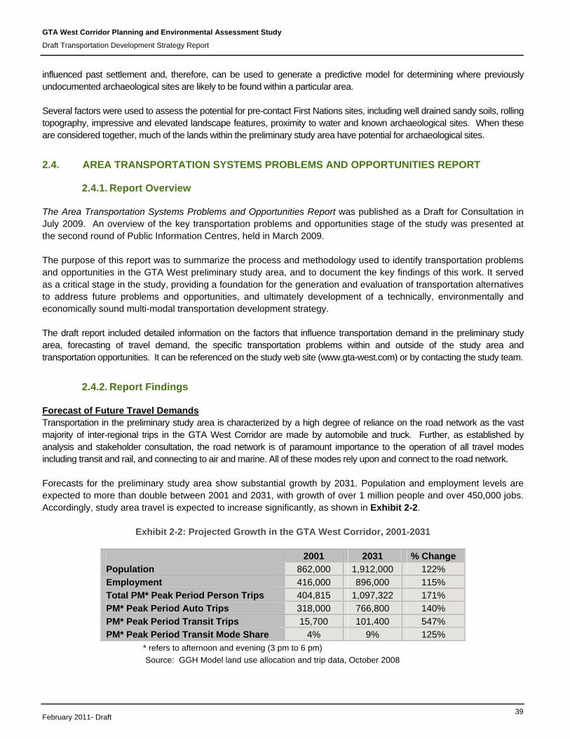
Forecast of Future Travel Demands Transportation in the preliminary study area is characterized by a high degree of reliance on the road network as the vast majority of inter-regional trips in the GTA West Corridor are made by automobile and truck. Further, as established by analysis and stakeholder consultation, the road network is of paramount importance to the operation of all travel modes including transit and rail, and connecting to air and marine. All of these modes rely upon and connect to the road network. Forecasts for the preliminary study area show substantial growth by 2031. Population and employment levels are expected to more than double between 2001 and 2031, with growth of over 1 million people and over 450,000 jobs. Accordingly, study area travel is expected to increase significantly, as shown in Exhibit 2-2.
Exhibit 2-2: Projected Growth in the GTA West Corridor, 2001-2031
2001 2031 % Change
Population 862,000 1,912,000 122%
Employment 416,000 896,000 115%
Total PM* Peak Period Person Trips 404,815 1,097,322 171%
PM* Peak Period Auto Trips 318,000 766,800 140%
PM* Peak Period Transit Trips 15,700 101,400 547%
PM* Peak Period Transit Mode Share 4% 9% 125%
* refers to afternoon and evening (3 pm to 6 pm)
Source: GGH Model land use allocation and trip data, October 2008

GTA West Corridor Planning and Environmental Assessment Study
Draft Transportation Development Strategy Report
February 2011- Draft 40
Future area transit improvements are expected to result in significant increases in transit trips, varying depending on trip origins and destinations. Additionally, analysis indicates that weekday PM traffic volumes are forecast to increase by 80% to 95% east of Winston Churchill Boulevard (near the central part of the preliminary study area), and between 70% and 130% east of Guelph. In the east of the preliminary study area, west of Highway 427, volumes are projected to increase by 25% by 2031. Canadian Pacific Railway (CPR) and Canadian National Railway (CNR) and VIA Rail operate in the preliminary study area, and rail use is anticipated to steadily increase through to 2031, driven largely by growth in volumes of containerized goods. Stakeholder consultation indicated that the existing infrastructure is anticipated to meet demand for the next 10 to 20 years. There are no major air and marine transportation facilities directly within the preliminary study area, although Toronto Pearson International Airport lies in close proximity to the southeast. The Ports of Toronto and Hamilton are the closest marine transportation facilities. Expansion is planned to meet future demand, which will result in increased automobile and truck traffic on the preliminary study area road network. Summary of Future Transportation Problems The overarching problem of the inter-regional transportation system in 2031 relates to the road network. Much of the higher order road system (i.e. highways and inter-regional roads) is expected to be heavily congested during peak periods and increasingly throughout the day. Road congestion in the summer is higher due to the overlay of tourism and recreational travel. Every mode connects to and relies on the road network, creating significant issues for the efficient movement of people and goods in the future. The transportation problems by travel markets (i.e. moving people – commuter, tourism and recreation, as well as moving goods) and modes are as follows: Moving People - Commuter Transit Future inter-regional transit connections, as provided in the Metrolinx RTP, will generally be oriented toward Toronto, including radial links to Vaughan, Brampton, Milton and Guelph. However, orbital inter-regional connections are more limited and indirect, requiring transfers and indirect travel routes. Other transit issues include the following:
Improvements may be needed in integration between local and inter-regional transit services, particularly beyond corridors served by GO Transit, in terms of physical connections, timetables and hours of service, fare structures and payment methods.
Roadway congestion limits the efficiency of bus transit services and increases unreliability and travel times.
The expansion of passenger and freight rail services within existing rail corridors creates potential for conflicts, particularly during peak commuting periods, as well as issues of scheduling and integration of rail services.
Automobile The road transportation system is the main mode for commuting in the preliminary study area, especially where trips are not served by higher order transit. As traffic volumes increase throughout the day, the traditional AM and PM peak commuting periods are becoming longer, resulting in study area highway congestion for much of the day.
GTA West Corridor Planning and Environmental Assessment Study
Draft Transportation Development Strategy Report
February 2011- Draft 41
Highways 401, 400, 410 and 427 are expected to experience major congestion throughout the day by 2031. The 407 ETR is expected to experience major congestion between Highways 400 and 427, and moderate congestion between Highways 427 and 401. Other major roadways such as Regional Road 124, Highway 7 and Highway 6 are also expected to experience growing congestion. Even with the planned improvements included in the Metrolinx RTP and GO Transit Strategic Plan, substantial daily congestion is forecast for 2031.
Major congestion issues are anticipated on the preliminary study area’s main highways, along Highways 401, 400, 410 and 427 within the study area’s boundary.
The expected capacity shortfall will increase automobile travel times between the preliminary study area’s Urban Growth Centres. Delays that occur due to collisions, inclement weather conditions, road maintenance and construction will contribute to congested conditions.
There is a lack of alternate higher order inter-regional routes to avoid congested conditions, particularly for travellers using the Highway 400 / Highway 401 corridors.
Moving People – Tourism and Recreation The problems for tourism and recreation travel are somewhat similar to those for commuter travel. Summer travel, when roadway congestion is greatest, is a particular issue for tourists. Transit The vast majority of tourism to, from and through the preliminary study area are forecast to continue to be by automobile, as limited transit systems are in place to serve tourist destinations and travel schedules, and in many instances, there is no reasonable alternative to the automobile. Further to this:
Improvements may be needed regarding transit connections between urban centres, tourist gateways such as Toronto Pearson International Airport and tourist destinations. Limited multi-modal connections are likely to increase car use even for those who travel to the preliminary study area by rail or air.
Where publicly funded transit services are in place or planned, schedules tend to cater to commuters rather than tourists, with services focused on AM and PM commuting times and limited weekend services.
Automobile The problems for road-based tourism and recreation travel include congestion, increased travel times, limited travel routes and modal options. Automobiles are used for more than 90% of visitors to the preliminary study area. In general, problems associated with tourism and recreation in terms or automobile are:
For the most part, the preliminary study area’s tourism and recreation destinations are connected to urban centres by Highway 401 and Highway 400, which regularly experience major congestion and heavy truck volumes. These trips through the preliminary study area are more likely to occur in the summer season.
There are inadequate connections between tourist gateways (e.g. airports) and tourism and recreation destinations.
Congestion results in increased and unpredictable travel times for tourists, and can negatively affect the tourist trip experience.
High volumes of trucks on the major highway corridors can be a deterrent to tourist travel, especially during the summer months.

GTA West Corridor Planning and Environmental Assessment Study
Draft Transportation Development Strategy Report
February 2011- Draft 42
Moving Goods The inter-regional road system is the primary distribution mode for moving goods in the area, shipping almost 70% of Canada-US trade by value and 45% by tonnage. The key collective issue for rail, air and marine modes relates to the limitations associated with the inter-regional road network from the perspective of access and/or congestion. Truck While the problems for goods movement by inter-regional road system are largely similar to those for automobile commuters, they can result in significant economic impacts to shippers, distributors, local businesses and industries. These problems include:
Increased congestion and travel times. Unpredictable travel times. Inadequate connections between Urban Growth Centres, commercial centres and inter-modal facilities. Diversion of trucks to regional and local roads, which results in out-of-way travel with associated
community, social, noise and safety concerns. Rail Rail services provide connections for goods movement in the preliminary study area, including inter-modal facilities with the road network. Much of the strong growth in rail and inter-modal goods movement has been driven by the growth in marine transport of containers. The key problems for rail transportation involve inter-modal connections to higher order roadways, as well as issues relating to congestion on the area road network. Other problems include:
Limited connectivity of inter-modal facilities, which can increase the difficulty of moving containers and other goods by rail and produce bottlenecks at the trucking interface.
Operational constraints on the rail network, including potential conflicts between rail-based transit and freight services, especially during peak commuting periods. As growth in freight and passenger traffic occurs on existing shared infrastructure, these problems will increase, potentially causing track capacity constraints.
Air Canada’s busiest airport, Toronto Pearson International Airport, is located approximately 3km to the southeast of the preliminary study area. Passenger and air cargo movements at this airport are expected to grow significantly over the next 25 years, which will increase runway capacity issues and pressure on the area road network.
The key problem for air transportation as it relates to the GTA West preliminary study area is congestion on the inter-regional road network.
Marine Marine port facilities are located to the south of the preliminary study area, in Toront and Hamilton. Marine movement of goods can be affected by bottlenecks at inter-modal facilities and by limitations of the St. Lawrence Seaway to handle ocean vessels on a year-round basis.
The major problem for marine transportation relates to congestion on the inter-regional roadway connections into the preliminary study area. Increased use of containers for shipping will also impose increased pressure on the road distribution network.
Summary of Future Transportation Opportunities In addition to identifying the transportation problems, an equally important aspect of this study is the identification of transportation opportunities, referring to the “big picture” strategic benefits of an efficient transportation system. These opportunities within the GTA West preliminary study area are summarized as follows:

GTA West Corridor Planning and Environmental Assessment Study
Draft Transportation Development Strategy Report
February 2011- Draft 43
1. Support Future Municipal Land Use Planning in Accordance with the Growth Plan The opportunity exists to co-ordinate multi-modal transportation and land use planning with municipal land use planning to support municipal growth aspirations that conform to the requirements of the Growth Plan, while at the same time accommodating both the local and inter-regional future travel demands.
2. Maintain the Character and Integrity of Rural and Agricultural Lands
There is an opportunity to avoid or minimize potential impacts to rural, agricultural and archaeological/heritage areas.
3. Provide Transportation Choice, Improved Connections and Increased Reliability for Commuters
The opportunity exists to build upon the Metrolinx RTP and GO Transit Strategic Plan to provide a robust transportation system that offers real alternatives to automobile travel throughout the study area.
4. Provide Transportation Choice, Improved Connections and Increased Reliability for Moving
Goods While trucks will continue to play an integral role in moving goods throughout and beyond the preliminary study area, there is an opportunity to encourage increased use of other modes for goods movement, including rail, marine and air, as well as to provide better connections between modes.
5. Provide Improved Transportation Service for Tourists
There is an opportunity to enhance the growth of tourism and recreation trips and the overall travel experience to the preliminary study area.
6. Optimize Existing Transportation Infrastructure
There are opportunities to use Transportation Demand Management (TDM) and Transportation Systems Management (TSM) strategies to reduce / shift trip making and automobile usage while optimizing use of the existing system.
7. Minimize Impacts to the Natural, Social, Economic and Cultural Environments to the Extent
Possible There is an opportunity to minimize, and potentially avoid, impacts to important natural, social, economic and cultural features at the earliest planning stages. This can be done through planning that optimizes use of existing infrastructure, and gives due regard to the requirements of approved provincial environmental protection policies, heritage resources and First Nations lands when developing and evaluating transportation alternatives.
2.5. OVERVIEW OF CORRIDOR PROTECTION AND DEVELOPMENT ISSUES PAPER
2.5.1. Report Overview
The Overview of Corridor Protection and Development Issues Paper was issued as a draft in June 2009, in order to capture the land development pressures and implications for transportation opportunities in the GTA West preliminary study area. The preliminary study area development pressures data have been updated throughout the study process and have been used in municipal consultation. An overview of the Areas of Interests (as defined below) and development pressures was presented at the second round of Public Information Centres in March 2009.

GTA West Corridor Planning and Environmental Assessment Study
Draft Transportation Development Strategy Report
February 2011- Draft 44
Development within the GTA West preliminary study area is occurring at a very fast pace. As a result, it was important to develop an approach to review development issues in order to protect corridor opportunities. The Overview of Corridor Protection and Development Issues Paper outlines the approach undertaken to complete this work. At the start of the study, data on current land use designations and development applications were collected from the upper-tier regions and counties as well as all lower-tier municipalities. This information was used to assemble a comprehensive and up to date land use map of the preliminary study area. This map was continuously updated as the study progressed to reflect amendments made by upper-tier and lower-tier municipalities to implement the Growth Plan, in particular to designate future growth areas.
2.5.2. Report Findings
Areas of Interest Following a review of current applications and planning studies occurring within the preliminary study area, ten Areas of Interest were identified between Highway 400 in the Region of York and the Hanlon Expressway in Township of Puslinch and the City of Guelph. These areas were identified as lands where future urban expansions or large development proposals would likely be considered by local municipalities and areas where potential connections between the growth centres may be compromised by future development plans. Areas of Interest were defined as areas where the Ontario Ministry of Transportation (MTO) should actively monitor and comment on all development applications as future urban expansions in these areas could limit corridor opportunities. These Areas of Interest are as follows:
Area #1 - Highway 400 Corridor at Kirby Road, City of Vaughan Area #2 - North of Major Mackenzie Drive to Kirby Road East of Highway 50 West of Kleinburg, City of
Vaughan Area #3 - South of Mayfield Road West of Regional Road 50, City of Brampton Area #4 - West of Coleraine Drive to Centreville Creek Road, North of Mayfield Road to Healey Road,
Town of Caledon Area #5 - Mayfield West Secondary Plan Area, Town of Caledon Area #6 - South of Mayfield Road East of Winston Churchill Boulevard, City of Brampton Area #7 - West of Winston Churchill Boulevard South, Town of Halton Hills Area #8 - North-West Milton at Highway 401 and Tremaine Road Area #9 - City Of Guelph – Southerly Limit at Hanlon Expressway (Highway 6) Area #10 - Township Of Puslinch – North Of Aberfoyle to Guelph Boundary and Hanlon
Expressway (Highway 6) Consultation and Collaboration Following the identification of the Areas of Interest a series of consultation meetings were held in February and March 2009, between the study team and upper and lower tier municipalities. The purpose of these meetings was to confirm the Areas of Interests and to develop a collaborative approach to review development applications and municipal planning studies. The municipal authorities agreed to provide information to the Ontario Ministry of Municipal Affairs and Housing (MMAH) and MTO regarding:
municipal planning studies; applications for Official Plan Amendments; applications for Plan of Subdivision or Condominium; and, applications for rezoning.
GTA West Corridor Planning and Environmental Assessment Study
Draft Transportation Development Strategy Report
February 2011- Draft 45
In the identified Areas of Interest, the approval authorities agreed to provide the Province with all of the information identified above. Outside of the Areas of Interest, the approval authorities agreed to provide the Ministry with Official Plan Amendments and applications for Condominium or Plans of Subdivision. Less information was required outside the Areas of Interest as these lands were essentially rural areas where little or no development is anticipated as the result of the Provincial policies including the PPS, the Greenbelt Plan and the Growth Plan. As a result of this collaborative approach, the Ministry has been able to provide comments on planning applications and municipally driven planning studies in an effort to ensure that a broad range of opportunities remained available during the course of this study. This approach has worked to a great extent to ensure that municipal planning decisions reflect the need to provide options for a transportation corridor through the preliminary study area. Levels of cooperation between municipalities have included involving MTO on Steering Committees for municipal planning studies. The process has been a relatively successful interim measure for corridor protection. However, once this first stage of the study is completed, it may be necessary for the Province to consider a more formal form of corridor protection to ensure that land development does not preclude the development of a transportation corridor that meets the needs of the GGH throughout this area. Alternative forms of corridor protection range from a Minister’s Zoning Order through the area to special legislation or an Amendment or Addendum to the Growth Plan related to the corridor. These stages of corridor protection will need to be considered further following the completion of this stage of the study.
2.6. AREA TRANSPORTATION SYSTEMS ALTERNATIVES REPORT
2.6.1. Report Overview
The purpose of the Area Transportation System Alternatives Report is to summarize the process and methodology that was used to develop a broad range of the Area Transportation System Alternatives and to document the key findings of this work. This report served as a critical stage in the study, providing a foundation for the further generation, evaluation and selection of Preliminary Planning Alternatives that have been incorporated into the ultimate TDS for this stage of the GTA West study. An overview of the transportation alternatives was presented at the third round of Public Information Centres (PICs), held in November and December 2009. The Area Transportation System Alternative Report provided further detail and background to the information presented at PIC#3. The report can be referenced on the study web site (www.gta-west.com) or by contacting the study team.
2.6.2. Report Findings
As discussed in detail in Chapter 3, a two-stage process was used for developing and assessing area transportation system alternatives. The first step involved the generation and assessment of individual alternatives and their ability to address future problems and opportunities (see Section 2.4). With significant stakeholder contribution and reviews of relevant practices in other jurisdictions, the following list of individual alternatives was developed:
Transportation Demand Management (TDM) and Transportation Systems Management (TSM) Transit Freight Rail Marine Air Freight Inter-Modal Roads and Highways

GTA West Corridor Planning and Environmental Assessment Study
Draft Transportation Development Strategy Report
February 2011- Draft 46
The assessment of the ‘long list’ of individual alternatives involved assessing the degree to which each alternative could meaningfully contribute to addressing the inter-regional transportation problems and opportunities that have been identified by the study team. The assessment of the individual transportation alternatives is summarized in Exhibit 2-3. The findings of this assessment identified numerous alternatives representing all transportation modes. One of the key findings, however, was that no single mode of transportation is capable of fully addressing all of the transportation problems and opportunities. As such, all of the individual transportation alternatives were carried forward for further consideration to the second stage of the process – the assembly of the “group” alternatives. Each of the group alternatives are described briefly below. Further detail with regard to the elements of each of the group alternatives are summarized in Chapter 3. Based on the study team’s assessment of the ‘long list’ of alternatives, the alternatives considered worthy of pursuing as part of the current study were grouped into each of the following categories:
Group #1: Optimize Existing Transportation Networks Transportation initiatives that focus on improving the performance of the existing transportation system for all modes of travel and transport through strategies designed to reduce auto and truck demand and improve system operating efficiency.
Group #2: New or Improved Non-Road Infrastructure This alternative builds upon the transportation system performance enhancements provided by Group #1 through provision of additional “non-road-based” capacity such as new air, marine, transit and freight rail infrastructure to address potential shortfalls in addressing the transportation problems and opportunities inherent in Group #1.
Group #3: Widen or Improve Roads This alternative builds upon the transportation system enhancements and non-road capacity improvements provided by Group #2 and adds new capacity by widening existing roads or highways beyond that which is currently planned or contemplated by municipalities and the Province.
Group #4: New Transportation Corridors This alternative builds upon the transportation system enhancements and both road and non-road capacity improvements provided by Group #1 and #2, as well as some existing road widening and improvements from Group #3, and adds new road and / or highway capacity on a new corridor to address identified transportation problems and opportunities.

GTA West Corridor Planning and Environmental Assessment Study
Draft Transportation Development Strategy Report
February 2011- Draft 47
Exhibit 2-3: Assessment of Individual Transportation Alternatives
MODE CARRIED
FORWARD
RATIONALE
Transportation
Demand Management
(TDM) Is recognized as an important component of
transportation networks but on its own it does not
provide a significant improvement to transportation
problems in the GTA West preliminary study area.
Transportation
Systems Management
(TSM) Is recognized as an important component of
transportation networks but on its own it does not
provide a significant improvement to transportation
problems in the GTA West preliminary study area.
Transit
Is recognized as an important component of a
transportation network for the movement of people;
however, on its own it does not provide a significant
resolution of the full range of transportation problems in
the GTA West preliminary study area.
Air
Improved multi-modal connections to the Toronto
Pearson International Airport have some potential to
reduce dependence on the road network in the GTA
West preliminary study area. Recommended to be
pursued by others or are already being pursued by
others.
Marine
Improved multi-modal connections to Port of Toronto /
Port of Hamilton have some potential to reduce
congestion on the road network in the GTA West
preliminary study area. Recommended to be pursued by
others or are already being pursued by others.
Freight Rail
Will continue to be an important aspect of goods
movement in the GTA West preliminary study area,
however there are no specific freight rail transportation
alternatives to be pursued as part of this study.
Inter-modal
Improved inter-modal facilities have some potential to
address transportation problems in the GTA West
preliminary study area, especially as they relate to the
movement of goods (i.e., rail to truck transfers etc.).
Roads and Highways
Are expected to provide significant improvement to
transportation problems in the GTA West preliminary
study area through widening of existing roads and / or
highways and potentially introduction of a new
transportation corridor.