2.0 lower rio grande background - new mexico environment department
TRANSCRIPT
6
2.0 LOWER RIO GRANDE BACKGROUND
The Lower Rio Grande Basin was intensively sampled by the Surface Water Quality Bureau (SWQB) from February to November 2004 and is addressed in this document. The Lower Rio Grande Basin includes perennial reaches of the Lower Rio Grande from the International Boundary with Mexico to Elephant Butte Dam, as well as tributaries that enter the Lower Rio Grande along those perennial reaches. Surface water quality monitoring stations were selected to characterize water quality of the stream reaches. Assessment units that will have a TMDL prepared in this document are discussed in their respective individual watershed sections. A number of assessment units could not be assessed due to insufficient data. These impairments will remain on the CWA Integrated §303(d)/§305(b) list of waters until additional data are available.
2.1 Location Description
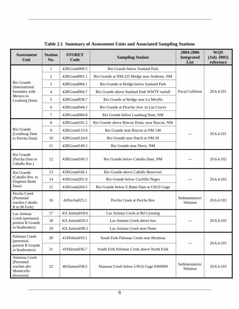
The Rio Grande originates in the San Juan Mountains of southern Colorado and follows a 1,885-mile course before it flows into the Gulf of Mexico. Along the way, the river and its tributaries drain a land area of 182,200 square miles. This drainage encompasses a widely varied landscape in the United States and Mexico, including mountains, forests, and deserts. The basin is home to diverse native plants and wildlife as well as some 10 million people. For approximately two-thirds of its course, the river also serves as the boundary between the United States and Mexico. The Lower Rio Grande watershed (US Geological Survey [USGS] Hydrologic Unit Codes [HUCs] 13030102 and 13030101) is located in Doña Ana, Sierra, and Socorro Counties in south-central New Mexico (NM). This survey included the geographic area draining into the portion of the Rio Grande located from Elephant Butte Dam to the New Mexico-Texas Border and the International Boundary with Mexico. At this point, the Rio Grande drains approximately 29,267 square miles (mi2). Twenty-two water quality sites were sampled during this survey (Figures 2.1 through 2.3). Table 2.1 details location descriptions of sampling stations in each assessment unit (AU), station numbers, STORET identification codes, the current listings on the Integrated CWA §303(d)/§305(b) Report, and the associated water quality segment number. The reader should bear in mind that these are the listings for the Lower Rio Grande Watershed prior to the survey. Landscapes range from forested mountains to desert grasslands to vegetated riparian zones. As presented in Figure 2.1, land use is approximately 82% rangeland, 12% forest, 2% agriculture, 2% barren, 1% riparian, and 1% urban. Figure 2.2 shows land ownership as 35% Bureau of Land Management (BLM), 32% private, 18% US Forest Service (USFS), 12% State, 2% Bureau of Reclamation, and 1% Department of Defense. Several species within this watershed are listed as either threatened or endangered by both State and Federal agencies. Federally listed endangered species include the Rio Grande silvery minnow (Hybognathus amarus), northern aplomado falcon (Falco femoralis septentrionalis), and southwestern willow flycatcher (Empidonax traillii extimus). Federally listed threatened species include the Mexican spotted owl (Strix occidentalis lucida). Additional species listed by the State as endangered include the common ground dove (Columbina passerine pallescens), interior least tern (Sterna antillarum athalassos), and desert bighorn sheep (Ovis Canadensis mexicana). Additional species listed by the State as threatened include the neotropic cormorant (Phalacrocorax brasilianus), common black-hawk (Buteogallus anthracinus anthracinus),
7
Lucifer hummingbird (Calothorax lucifer), Costa’s hummingbird (Calypte costae), broad-billed hummingbird (Cynanthus laitrostris), Bell’s vireo (Vireo bellii), gray vireo (Vireo vicinior), Baird’s sparrow (Ammodramus bairdii), varied bunting (Passerina versicolor), spotted bat (Euderma maculatum), and the Doña Ana talussnail (Sonorella todseni). In this mostly arid to semiarid region, the absence of flow in the river as well as the presence of flow determines the basin's character. Two-thirds of the annual precipitation (7.8 inches) is packed into the late summer and early fall (La Mar 1984). Many of the river tributaries are intermittent streams and much of the flow is controlled by numerous reservoirs in the basin. Throughout the basin, an extensive system of water structures captures and controls the flow of water in the subbasins to meet regional needs for flood control, power generation, and storage for domestic, agricultural, and industrial purposes. Ranching and irrigated agriculture is a major component of the economy in the basin. The Lower Rio Grande offers a 247-day growing season where temperatures can soar to 111 degrees Fahrenheit (°F) and plummet to –16 °F. The various state parks and reservoirs located along the river support activities such as hiking, mountain biking, camping, and fishing as well as water skiing and other recreational sports.
8
Table 2.1 Summary of Assessment Units and Associated Sampling Stations
Assessment Unit
Station No.
STORET Code Sampling Station
2004-2006 Integrated
List
WQS (July 2005) reference
1 42RGrand000.5 Rio Grande below Sunland Park
2 42RGrand001.1 Rio Grande at NM-225 Bridge near Anthony, NM
3 42RGrand004.1 Rio Grande at Bridge below Sunland Park
4 42RGrand004.7 Rio Grande above Sunland Park WWTF outfall
5 42RGrand038.7 Rio Grande at Bridge near La Mesilla
6 42RGrand044.2 Rio Grande at Picacho Ave. in Las Cruces
Rio Grande (International boundary with Mexico to Leasburg Dam)
7 42RGrand084.8 Rio Grande below Leasburg Dam, NM
Fecal Coliform 20.6.4.101
8 42RGrand101.2 Rio Grande above Rincon Drain, near Rincon, NM
9 42RGrand115.0 Rio Grande near Rincon at NM 140
10 42RGrand124.0 Rio Grande near Hatch at NM 26
Rio Grande (Leasburg Dam to Percha Dam)
11 42RGrand149.5 Rio Grande near Derry, NM
--- 20.6.4.101
Rio Grande (Percha Dam to Caballo Res.)
12 42RGrand160.3 Rio Grande below Caballo Dam, NM --- 20.6.4.102
13 41RGrand184.1 Rio Grande above Caballo Reservoir
14 41RGrand201.0 Rio Grande below Cuchillo Negro
Rio Grande (Caballo Res. to Elephant Butte Dam) 15 41RGrand204.5 Rio Grande below E.Butte Dam at USGS Gage
--- 20.6.4.103
Percha Creek (Perennial reaches Caballo R to M Fork)
16 41Percha025.3 Percha Creek at Percha Box Sedimentation/Siltation 20.6.4.103
17 41LAnima018.6 Las Animas Creek at Rd Crossing
18 41LAnima029.3 Las Animas Creek above box
Las Animas Creek (perennial portion R Grande to headwaters) 19 41LAnima038.3 Las Animas Creek near Dunn
--- 20.6.4.103
20 41SPalom019.1 South Fork Palomas Creek near Hermosa Palomas Creek (perennial portion R Grande to headwaters) 21 41Paloma036.7 South Fork Palomas Creek above North Fork
--- 20.6.4.103
Alamosa Creek (Perennial reaches abv Monticello diversion)
22 40Alamos058.5 Alamosa Creek below USGS Gage 8360000 Sedimentation/Siltation 20.6.4.103
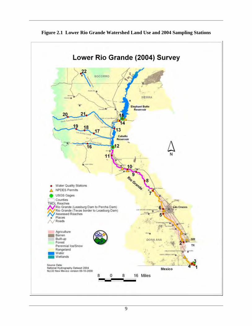
Figure 2.1 Lower Rio Grande Watershed Land Use and 2004 Sampling Stations
9
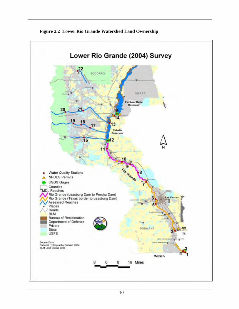
Figure 2.2 Lower Rio Grande Watershed Land Ownership
10
11
2.2 History and Geology
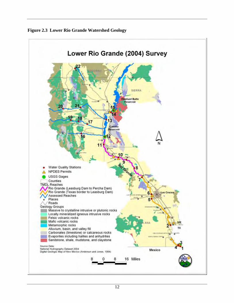
The Spanish Empire’s entradas for colonization and conversion first made their way up the Rio Grande led by explorer Alvar Nuñez Cabeza de Vaca in 1536. Wandering inland in search of the mythic “Seven Cities of Cibola,” Cabeza de Vaca and his band never found gold, but they did uncover an unexpected surprise. The conquistadors and priests found Pueblo Indians irrigating and cultivating almost 30,000 acres of maize, beans, and calabashes. The Spanish arrival instigated a hundred year test of wills between the Europeans and the Pueblos. At the beginning of the seventeenth century, a mission established by fathers at El Paso del Norte (modern Juarez, Mexico) began schooling the Indians in more advanced methods of growing crops, aided by water provided by the Acequia Madre (Main Canal). In 1680, an Indian revolt drove the Spanish and Christianized Indians south from New Mexico to present-day Juarez, Mexico and Yselta, Texas. Don Diego de Vargas began the reconquest of New Mexico twelve years later and the Spanish influence over the Rio Grande was cemented into place (Autobee 1994). In the following 150 years, up to 40,000 acres of land were tilled along the river. Around 1890, extensive settlement and irrigation development in southern Colorado, in addition to that which had already taken place in central New Mexico, depleted the normal summer flow of the Rio Grande, causing the river to be dry at El Paso for more frequent and longer periods. To resolve this issue, Elephant Butte Dam and Reservoir and its companion structure, Caballo Dam and Reservoir, were constructed and started storing water for irrigation purposes as early as 1916. Historic and current land uses in the watershed include agriculture, recreation, and municipal related activities (Las Cruces, El Paso). Much of the land ownership adjacent to the river is private with the exception of state parks near Elephant Butte Lake, Caballo Lake, Percha Dam, and Leasburg Dam. The Bureau of Land Management and the State of New Mexico also own and manage sizable tracts of public lands in the upland portions of the watershed. The Lower Rio Grande watershed is located in Omernick Level III Ecoregion 24 (the Chihuahuan Deserts) contained within Aggregate Ecoregion 3 (the Xeric West). The elevation range for the various sampling sites in the survey was 3720’ to 4500’. The surrounding geology was shaped by the Rio Grande Rift system. The Rio Grande Rift system is a series of grabens (fault-bounded basins) that extend from central Colorado southward through New Mexico and into western Texas and Mexico. Continental rifting was associated with crustal stretching and uplift of the southwestern United States. Grabens dropped down thousands of meters relative to adjacent uplifts, and alluvial sediment accumulated to great thickness in the basins. Intrusions and volcanic eruptions also took place within the rift valleys and throughout the surrounding region.
12
Figure 2.3 Lower Rio Grande Watershed Geology
13
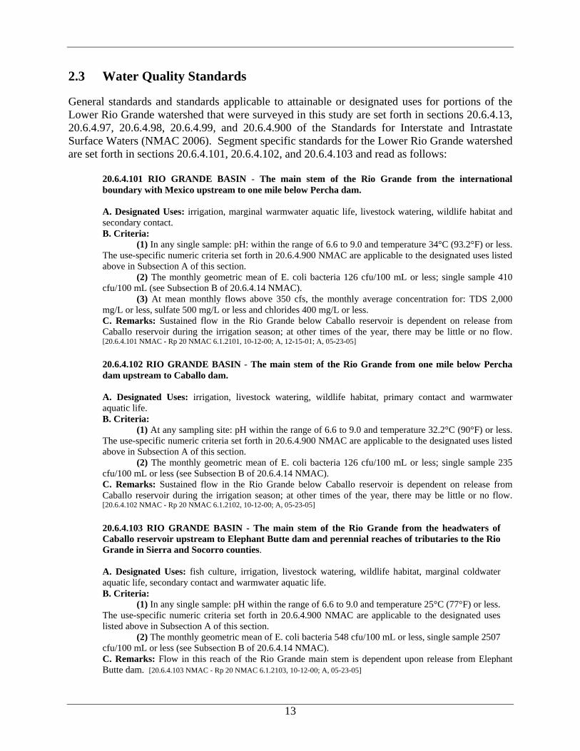
2.3 Water Quality Standards
General standards and standards applicable to attainable or designated uses for portions of the Lower Rio Grande watershed that were surveyed in this study are set forth in sections 20.6.4.13, 20.6.4.97, 20.6.4.98, 20.6.4.99, and 20.6.4.900 of the Standards for Interstate and Intrastate Surface Waters (NMAC 2006). Segment specific standards for the Lower Rio Grande watershed are set forth in sections 20.6.4.101, 20.6.4.102, and 20.6.4.103 and read as follows:
20.6.4.101 RIO GRANDE BASIN - The main stem of the Rio Grande from the international boundary with Mexico upstream to one mile below Percha dam. A. Designated Uses: irrigation, marginal warmwater aquatic life, livestock watering, wildlife habitat and secondary contact. B. Criteria:
(1) In any single sample: pH: within the range of 6.6 to 9.0 and temperature 34°C (93.2°F) or less. The use-specific numeric criteria set forth in 20.6.4.900 NMAC are applicable to the designated uses listed above in Subsection A of this section.
(2) The monthly geometric mean of E. coli bacteria 126 cfu/100 mL or less; single sample 410 cfu/100 mL (see Subsection B of 20.6.4.14 NMAC).
(3) At mean monthly flows above 350 cfs, the monthly average concentration for: TDS 2,000 mg/L or less, sulfate 500 mg/L or less and chlorides 400 mg/L or less. C. Remarks: Sustained flow in the Rio Grande below Caballo reservoir is dependent on release from Caballo reservoir during the irrigation season; at other times of the year, there may be little or no flow. [20.6.4.101 NMAC - Rp 20 NMAC 6.1.2101, 10-12-00; A, 12-15-01; A, 05-23-05]
20.6.4.102 RIO GRANDE BASIN - The main stem of the Rio Grande from one mile below Percha dam upstream to Caballo dam. A. Designated Uses: irrigation, livestock watering, wildlife habitat, primary contact and warmwater aquatic life. B. Criteria:
(1) At any sampling site: pH within the range of 6.6 to 9.0 and temperature 32.2°C (90°F) or less. The use-specific numeric criteria set forth in 20.6.4.900 NMAC are applicable to the designated uses listed above in Subsection A of this section.
(2) The monthly geometric mean of E. coli bacteria 126 cfu/100 mL or less; single sample 235 cfu/100 mL or less (see Subsection B of 20.6.4.14 NMAC). C. Remarks: Sustained flow in the Rio Grande below Caballo reservoir is dependent on release from Caballo reservoir during the irrigation season; at other times of the year, there may be little or no flow. [20.6.4.102 NMAC - Rp 20 NMAC 6.1.2102, 10-12-00; A, 05-23-05]
20.6.4.103 RIO GRANDE BASIN - The main stem of the Rio Grande from the headwaters of Caballo reservoir upstream to Elephant Butte dam and perennial reaches of tributaries to the Rio Grande in Sierra and Socorro counties. A. Designated Uses: fish culture, irrigation, livestock watering, wildlife habitat, marginal coldwater aquatic life, secondary contact and warmwater aquatic life. B. Criteria:
(1) In any single sample: pH within the range of 6.6 to 9.0 and temperature 25°C (77°F) or less. The use-specific numeric criteria set forth in 20.6.4.900 NMAC are applicable to the designated uses listed above in Subsection A of this section.
(2) The monthly geometric mean of E. coli bacteria 548 cfu/100 mL or less, single sample 2507 cfu/100 mL or less (see Subsection B of 20.6.4.14 NMAC). C. Remarks: Flow in this reach of the Rio Grande main stem is dependent upon release from Elephant
Butte dam. [20.6.4.103 NMAC - Rp 20 NMAC 6.1.2103, 10-12-00; A, 05-23-05]
14
The New Mexico Environment Department (NMED) proposed several modifications to the New Mexico WQS during the February 2004 triennial review hearing. Changes that will potentially affect the Lower Rio Grande watershed are:
• Changing the criteria related to contact uses from fecal coliform to E. coli (monthly
geometric mean of 126 colony forming units (cfu)/100 mL or less in 20.6.4.101 and 20.6.4.102, monthly geometric mean of 548 cfu/100 mL in 20.6.4.103; single sample 410 cfu/100 mL in 20.6.4.101, single sample 235 cfu/100 mL in 20.6.4.102, and single sample 2507 cfu/100 mL in 20.6.4.103).
The State of New Mexico Water Quality Control Commission (WQCC) adopted the proposed WQS changes as of July 17, 2005.
2.4 Intensive Water Quality Sampling
The Lower Rio Grande watershed was intensively sampled by the SWQB in 2004. A brief summary of the survey and the hydrologic conditions during the intensive sample period is provided in the following subsections.
2.4.1 Survey Design
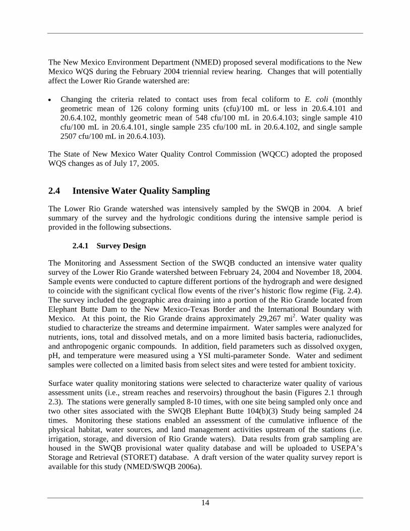
The Monitoring and Assessment Section of the SWQB conducted an intensive water quality survey of the Lower Rio Grande watershed between February 24, 2004 and November 18, 2004. Sample events were conducted to capture different portions of the hydrograph and were designed to coincide with the significant cyclical flow events of the river’s historic flow regime (Fig. 2.4). The survey included the geographic area draining into a portion of the Rio Grande located from Elephant Butte Dam to the New Mexico-Texas Border and the International Boundary with Mexico. At this point, the Rio Grande drains approximately 29,267 mi2. Water quality was studied to characterize the streams and determine impairment. Water samples were analyzed for nutrients, ions, total and dissolved metals, and on a more limited basis bacteria, radionuclides, and anthropogenic organic compounds. In addition, field parameters such as dissolved oxygen, pH, and temperature were measured using a YSI multi-parameter Sonde. Water and sediment samples were collected on a limited basis from select sites and were tested for ambient toxicity. Surface water quality monitoring stations were selected to characterize water quality of various assessment units (i.e., stream reaches and reservoirs) throughout the basin (Figures 2.1 through 2.3). The stations were generally sampled 8-10 times, with one site being sampled only once and two other sites associated with the SWQB Elephant Butte 104(b)(3) Study being sampled 24 times. Monitoring these stations enabled an assessment of the cumulative influence of the physical habitat, water sources, and land management activities upstream of the stations (i.e. irrigation, storage, and diversion of Rio Grande waters). Data results from grab sampling are housed in the SWQB provisional water quality database and will be uploaded to USEPA’s Storage and Retrieval (STORET) database. A draft version of the water quality survey report is available for this study (NMED/SWQB 2006a).
15
All temperature and chemical/physical sampling and assessment techniques are detailed in the Quality Assurance Project Plan (QAPP, NMED/SWQB 2004b) and the SWQB Assessment Protocols (NMED/SWQB 2006b). As a result of the 2004 monitoring effort and subsequent assessment of results, several surface water impairments were determined.
2.4.2 Hydrologic Conditions
Streamflow in the Lower Rio Grande is controlled largely by releases from Elephant Butte Reservoir. As Figure 2.4 demonstrates, flows in Lower Rio Grande (USGS Gage 08361000) during the 2004 survey year were below average based on the period of record, except for March (spring snowmelt), July (summer monsoons), and a brief peak in August (also summer monsoons). As stated in the Assessment Protocol (NMED/SWQB 2006b), data collected during all flow conditions, including low flow conditions (i.e. flows below the 4-day, 3-year low-flow frequency [4Q3]), will be used to determine designated use attainment status during the assessment process. In terms of assessing designated use attainment in ambient surface waters, WQS apply at all times under all flow conditions.
1
10
100
1000
10000
J F M A M J J A S O
Month
Ave
rage
Dai
ly F
low
(cfs
)
Average Daily Flow 2004 Average Daily Flow 1916-2004
Figure 2.4 Streamflow at Rio Grande below Elephant Butte Dam (USGS Gage 08361000)
16
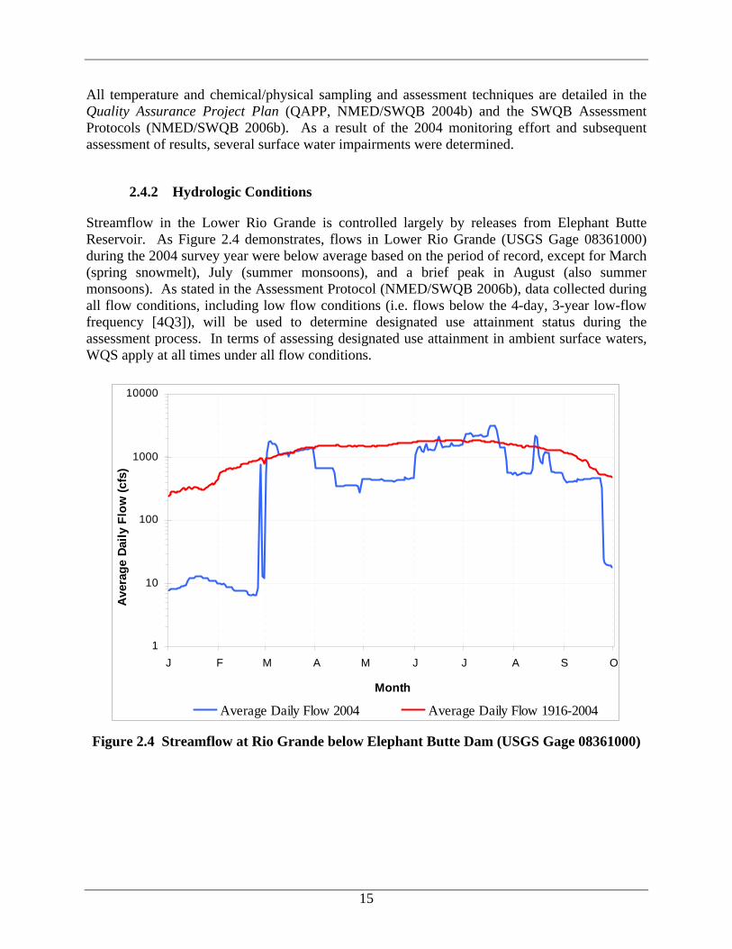
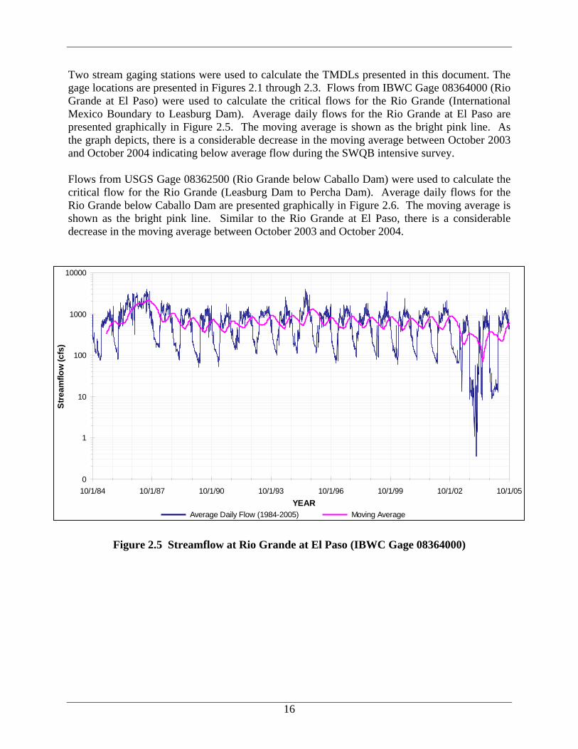
Two stream gaging stations were used to calculate the TMDLs presented in this document. The gage locations are presented in Figures 2.1 through 2.3. Flows from IBWC Gage 08364000 (Rio Grande at El Paso) were used to calculate the critical flows for the Rio Grande (International Mexico Boundary to Leasburg Dam). Average daily flows for the Rio Grande at El Paso are presented graphically in Figure 2.5. The moving average is shown as the bright pink line. As the graph depicts, there is a considerable decrease in the moving average between October 2003 and October 2004 indicating below average flow during the SWQB intensive survey. Flows from USGS Gage 08362500 (Rio Grande below Caballo Dam) were used to calculate the critical flow for the Rio Grande (Leasburg Dam to Percha Dam). Average daily flows for the Rio Grande below Caballo Dam are presented graphically in Figure 2.6. The moving average is shown as the bright pink line. Similar to the Rio Grande at El Paso, there is a considerable decrease in the moving average between October 2003 and October 2004.
0
1
10
100
1000
10000
10/1/84 10/1/87 10/1/90 10/1/93 10/1/96 10/1/99 10/1/02 10/1/05YEAR
Stre
amflo
w (c
fs)
Average Daily Flow (1984-2005) Moving Average
Figure 2.5 Streamflow at Rio Grande at El Paso (IBWC Gage 08364000)
17
0
1
10
100
1000
10000
10/1/84 10/1/87 10/1/90 10/1/93 10/1/96 10/1/99 10/1/02 10/1/05YEAR
Stre
amflo
w (c
fs)
Average Daily Flow (1984-2005) Moving Average Figure 2.6 Streamflow at Rio Grande below Caballo Dam (USGS Gage 08362500)