2000 geological and geochemical program on the armour …
TRANSCRIPT
Rimfire Minerals Corporation
2000 GEOLOGICAL AND GEOCHEMICAL PROGRAM ON THE ARMOUR PROPERTY
Located near Barriere Karnloops Mining District
NTS 92Pll E 51' 09 North Latitude
120" 06 West Longitude
-prepared for-
RIMFIRE MINERALS CORPORATION 700-700 West Pender Street
Vancouver, B.C., Canada V6C 1 G8
-prepared by-
David A. Caulfield, P.Geo
700-700 West PenderStreet. Vancouver, B.C., Canada
V6C 1G8
., . .- . I 1' ' . I
SUMMARY
The Armour claim, consisting of 20 units, covers Mount Armour which is located immediately east of Barriere in south central B.C., 65 kilometres north of Kamloops. The property is accessible by truck and much of the property can be accessed by a network of logging roads and skidder trails. The claim is ideally situated adjacent to a major power line, the CN railroad mainline and the Yellowhead Highway. The property is owned 100% by Rimfire Minerals Corporation with no underlying royalties.
i
The property was staked for Rimfire Minerals Corporation in October 1997 to cover two massive sulphide occurrences: the Main and South showings. These showings were first discovered in the early 1900s. In 1979, Craigmont Mines Limited carried out soil geochemical and geophysical (VLF, mag) surveys. Craigmont noted coincidental soil and VLF anomalies with the sulphide showings; however, a recommended drill program was not carried out. Corporation Falconbridge Copper (Minnova) conducted soil geochemistry (1293 samples), IP geophysics and 410.3 metres of NQ core drilling in five holes in 1985-86. They were successful in targeting the Main Zone mineralization, cutting massive sulphide mineralization in two holes. The best intercept, in hole AR #I, contained 4.10% Zn over 1.04 metres. Hole AR #4 failed to intersect the South Showing due to the positioning and orientation of the hole. Holes AR #3 and AR #5 failed to explain the soil geochemistry at which they were targeted.
The property is underlain by mafic metavolcanics, chert, argillite, wacke, tuff, quartz pebble conglomerate and massive sulphides of lower units of the Paleozoic Eagle Bay Assemblage. In the Adams Plateau-Clearwater area, the Paleozoic metasedimentary and metavolcanic stratigraphy host Kuroko-type, polymetallic precious and base metal VMS deposits in the upper part of the Eagle Bay Assemblage and Cyprus-type, Cu-Zn dominant, VMS deposits in the Fennel1 Formation.
The Main and South showings consist of multiple lenses of syngenetic, fine- grained pyrite laminae crosscut by coarse-grained pyrite in blebs, stringers and quartz veinlets hosted in argillitelphyllite. Sampling of both showings returned anomalous CuAu values with low Pb, Zn and Ba. The 1986 drilling and soil geochemistry indicate that metal zonation does occur and that higher Ag, Pb and Zn values can be expected elsewhere. The sedimentary-dominant stratigraphy of the Armour property would seem to indicate that the mineralization occurs in a Besshi-type environment.
The sulphide occurrences lie within a 650 by 600 metre area of anomalous Cu-Pb- Zn-Au-Ag soil geochemistry and are coincidental with VLF-EM conductors. The drilling has shown that individual lenses can reach thicknesses of 7.8 metres and better base metal values can be expected. It is on this basis that further work is fully recommended. The next phase of exploration would entail completion of the 1985 grid restoration, prospecting and detailed surficial and bedrock geological mapping. The soil grid should be extended south and the grid surveyed with more sophisticated EM, before targets are selected for drilling or trenching.
SUMMARY INTRODUCTION LIST OF CLAIMS LOCATION, ACCESS AND GEOGRAPHY PROPERTY EXPLORATION HISTORY 2000 EXPLORATION PROGRAM REGIONAL GEOLOGY PROPERTY GEOLOGY 7.1 Main Showing 7.2 South Showing GEOCHEMISTRY DISCUSSION
1 .o 2.0 3.0 4.0 5.0 6.0 7.0
8.0 9.0
2000 GEOLOGICAL AND GEOCHEMICAL PROGRAM ON THE ARMOUR PROPERTY
TABLE OF CONTENTS
.I.
. I .
.2.
. I .
.3.
.3.
.4.
.4.
.5.
.6.
.6.
. I .
APPENDICES
Appendix A Bibliography Appendix B Statement of Expenditures Appendix C Certificates of Analysis Appendix D Soil Sample Statistics Appendix E Geologists’ Certificates
LIST OF TABLES
Table 2.0.1 Claim Data Table 4.0.1 Drill Hole Survey Data Table 7.1.1 Rock Sample Results - Main Zone and Area Table 7.1.2 Significant Drill Intercepts - 1986 Drilling Table 7.2.1 Rock Sample Results - South Zone
LIST OF FIGURES
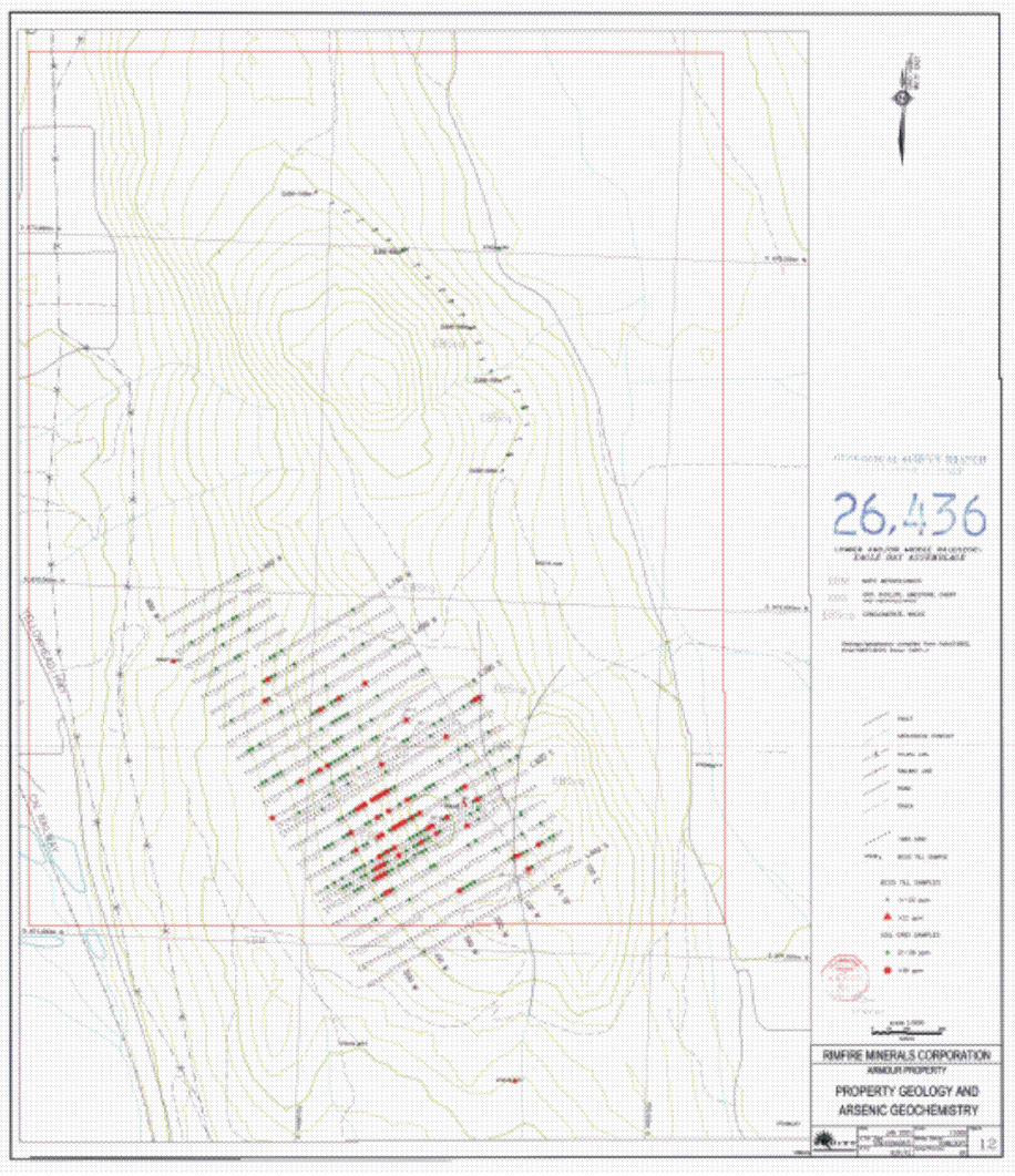
Figure 1 Figure 2 Figure 3 Figure 4 Figure 5 Figure 6 Figure 7 Figure 8 Figure 9 Figure 10 Figure 11 Figure 12
Property Location Map Claim Map Regional Geology Property Geology Main Showing Area South Showing Area Property Geology and Copper Geochemistry Property Geology and Lead Geochemistry Property Geology and Zinc Geochemistry Property Geology and Gold Geochemistry Property Geology and Silver Geochemistry Property Geology and Arsenic Geochemistry
w . I . .2. .4. .5. .5.
Following
.I.
.I . -Pocket- -Pocket-
.4.
.5. -Pocket- -Pocket- -Pocket- -Pocket- -Pocket- -Pocket-
1.0 INTRODUCTION 1
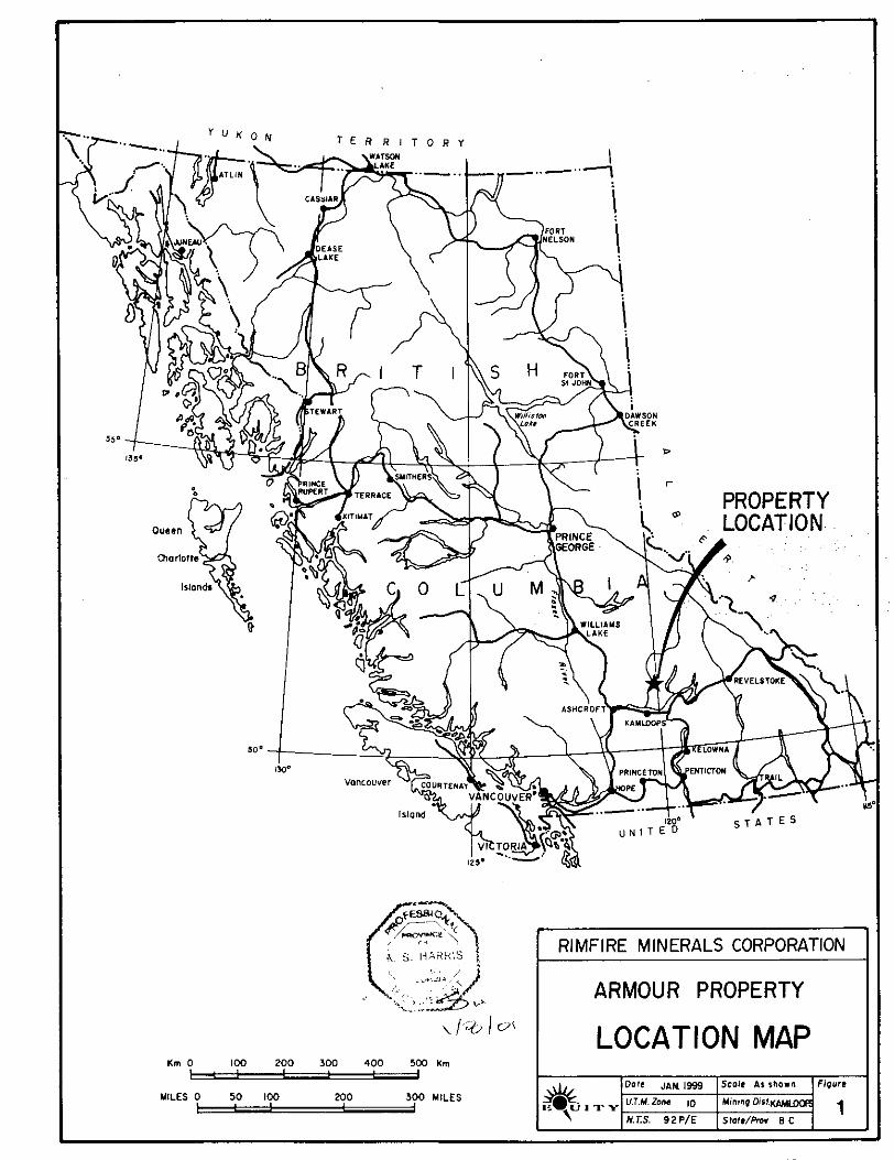
The Armour property is centred over Mount Armour, immediately east of Barriere, in south central B.C. (Figure 1). In October 1997, Rimfire Minerals Corporation acquired the property by staking.
The massive sulphide occurrences were likely discovered on Mount Armour in the early 1900's. A local prospector conducted limited drilling in the late 1960s with inconclusive results (Vollo, 1980). In 1979, Craigmont Mines carried out soil geochemistry and magnetometerNLF geophysical surveys, although anomalies defined by their work were never followed up. In November 1985, Corporation Falconbridge Copper, under option to Cutty Resources Inc., established a grid covering the known showings, carrying out soil and geophysical surveys. Its successor company, Minnova Inc., conducted a five hole diamond drill program the following November, intersecting massive sulphide horizons in two of their holes.
On October 15 of 2000, Rimfire Minerals Corporation conducted a limited exploration program on the Armour property consisting of contour soil sampling and geological mapping. This work was completed by Equity Engineering Ltd. which has also been retained to report on the results of the fieldwork.
2.0 LIST OF CLAIMS
The Armour property is comprised of one 20 unit modified grid claim block within the Kamloops Mining District (Figure 2). The legal corner post is located along the Dixon Creek access road and its position was noted by the senior author. The Armour property is 100% owned by Rimfire Minerals Corporation. The expiry date listed is subject to approval of assessment work covered by this report. The surface rights on the property are held by private individuals or corporations.
CLAIM DATA Table 2.0.1
Claim Name I Mineral Tenure No. I No. of Units I Record Date I Expiry Year Armour 359822 20 I October 16, 1997 I 2001
3.0 LOCATION, ACCESS AND GEOGRAPHY
The Armour property is located immediately southeast of the town of Barriere, 65 kilometres north of Kamloops, B.C. (Figure 1). The property is accessed from the Dixon Creek Road, on the east side of Mount Armour, 1.9 kilometres north of the junction with the Squaam (Agate) Bay Road. The property is crossed by a series of logging roads, most of which are easily traversed with a two-wheel drive vehicle. The area is centred at 51' 09 north latitude and 120' 06' west longitude (map sheet 92PAE). The property is adjacent to the Yellowhead Highway, the CN railroad mainline, and has a power line cutting through the west side of the property. Exploration programs are best accessed out of the town of Barriere which has motels, restaurants and outlets for basic supplies.
The property covers most of Mount Armour which rises fairly steeply from the North Thompson River valley at approximately 425 metres to over 750 metres on the north peak of Mount Armour. The massive sulphide showings occupy the rolling, southern part of Mount Armour. It is sparsely forested, consisting of grasslands with pine and Douglas fir which are being selectively logged by locally-based sawmill operations. The climate is typical of Interior B.C., having hot dry summers with temperatures reaching 35" C and colder winters to -30" C. No permanent water exists on the property. Outcrop exposure is variable depending on steepness of terrain; in the immediate area of the massive sulphide showings, outcrop exposure is less than 5%.
&, 5 . HAi lk lS RIMFIRE MINERALS CORPORATION
urn 0 1 0 0 200 3W 400 500 Urn 1 : : 1
MILES 0 50 1 0 0 200 300 MILES
LOCATION MAP

n
4.0 PROPERTY EXPLORATION HISTORY L
Hand trenching on the massive sulphide occurrences on Mount Armour probably dates back to the early 1900s. A local prospector, J.A. Fennel1 attempted to drill the Main Showing in the late 1960s with inconclusive results (Vollo, 1980). Spilt sections of core from this drilling are located near the Main Showing (Figure 5).
In 1979, Craigmont Mines Limited carried out soil geochemistry and magnetometerNLF geophysical surveys over the sulphide showings (Vollo, 1980). Soil samples (340) were collected at 50 metre intervals on lines 100 metres apart. The -80 mesh soil fraction was analyzed for Cu, Pb, Zn and Ag. Approximately 20 kilometres of grid was chained and surveyed by VLF-EM (Ronka EM-16) and magnetometer (Geometrics G-836). The magnetometer survey indicated low magnetic relief. Vollo (1980) noted a correlation between geochemical highs, VLF conductors and massive sulphide exposures and recommended drilling, although this recommendation was never followed up. The axes of Fraser-filtered EM anomalies are shown on Figure 4.
In November 1985, Corporation Falconbridge Copper, under option to Cutty Resources Inc. established a grid covering the known showings, and carried out a soil survey (Pirie, 1986). Falconbridge cut 10.4 kilometres of line and collected 1292 soil samples for Cu, Pb, Zn, Au, Ag and As
The baseline is oriented 330"/150" with stations spaced 12.5 metres apart on crosslines every 50 metres analyses on the -80 mesh fraction using aqua regia-atomic absorption and ICP analytical techniques.
or, in the case of mineralized areas, every 25 metres apart. Sometime after this program but prior to drilling the following year, Falconbridge conducted an induced polarization (IP) survey. As this work was not filed for government assessment, details of the IP survey are not known although anomalies from this survey are highlighted in the drill report (Pirie, 1987) and presented on Figure 4.
The following November, Falconbridge's successor company, Minnova Inc., conducted a five hole, 410-metre NQ diamond drill program. The program was designed to test the known showings and some of the soil geochemical anomalies; two of the holes intersected massive sulphide horizons. A summary of drill survey data is contained in Table 4.0.1. The location and condition of the core from this program are not known.
DRILL HOLE SURVEY DATA Table 4.0.1
Hole Azimuth Dip Depth Grid South Grid West (m)
AR # I 215" -50" 75.7 235 125 AR #2 21 5" -50" 84.1 184 140 AR #3 21 5" -50" 102.1 230 230
Coordinates Coordinates
AR #4 140" -60" 54.5 490 225 AR #5 120" -50" 93.9 737 088
I 410.3 I
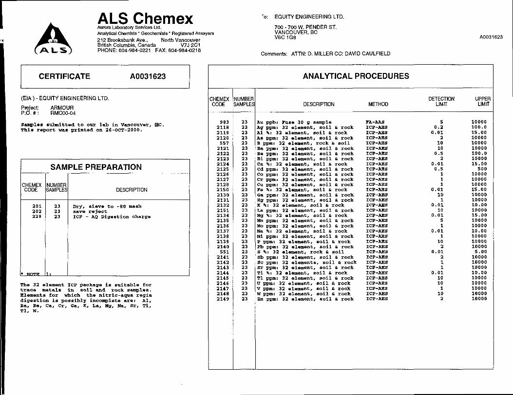
In 1998 Rimfire Minerals Corp. examined and sampled the two massive sulphide occurrences. Sixteen rock samples were collected; three of which were analyzed for whole rock. Field locations are marked by metal tag and a combination of pink and blue flagging. Samples were shipped to Chemex Labs to be analyzed for Au, Ba and 32 elements by ICP. The three whole rock samples were analyzed by XRF (Caulfield, 1999).
The 1985 grid baseline was re-established between OOON and 500s. Crosslines ZOOS, 250s and 500s were re-run 400, 400 and 275 metres, respectively, to the west. On these lines, enough old pickets were found to be confident that the 1985 grid can be re-established and used in future surveys.

L
3 5.0 2000 EXPLORATION PROGRAM
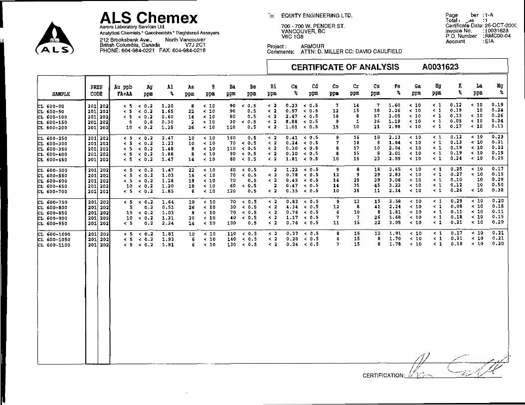
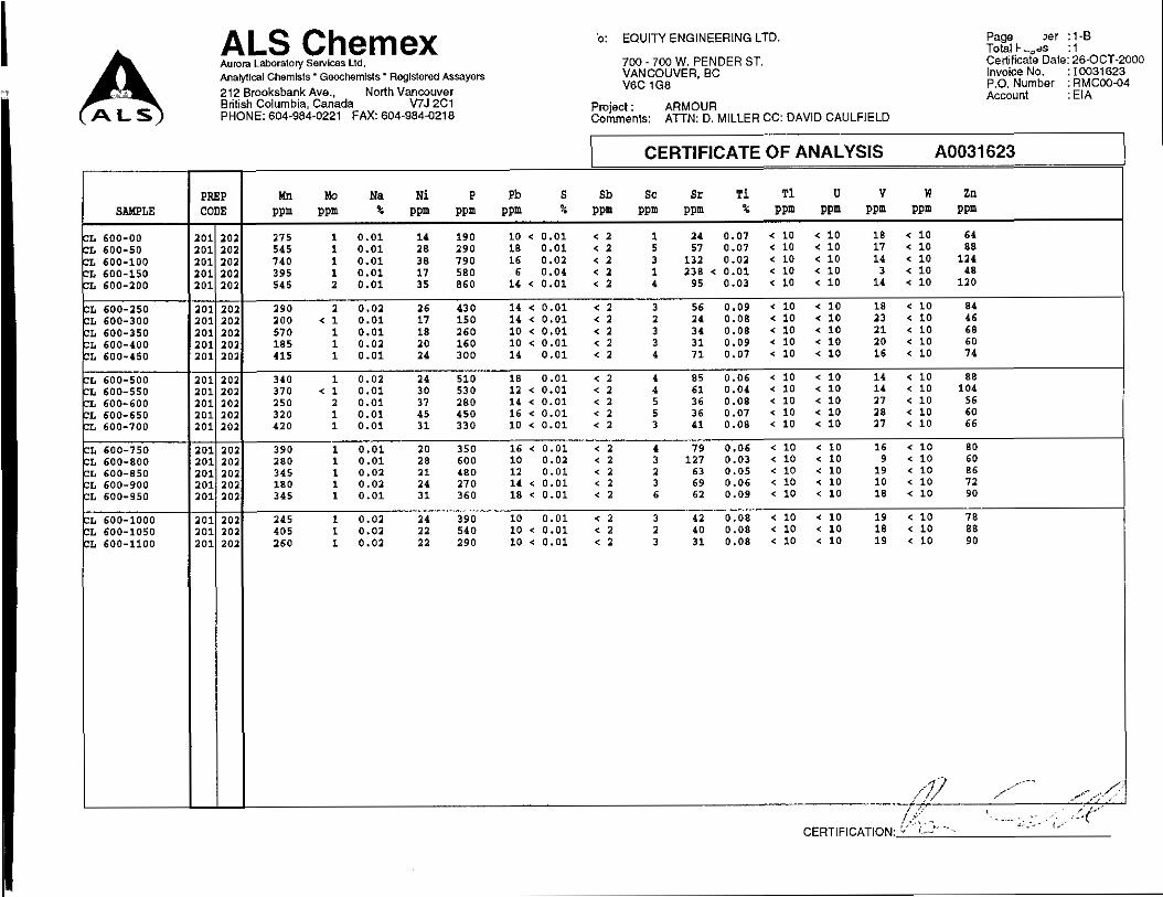
A series of contour soil samples were collected from the “6 soil horizon at 50-metre intervals along the 600 m.a.s.1. contour in the northeast corner of the property, on the northeast-facing slope of
ALS/Chemex Labs to be analyzed for Au by FA/AA, and 34 elements by ICP. Limited geological Mount Armour. Field locations are marked by a tyvek tag and flagging tape. Samples were shipped to
mapping was carried out in conjunction with the contour soil sampling. A magnetic declination of 20” 17’ east of true north was used for all compass work. The NAD-83 datum was used for report figures.
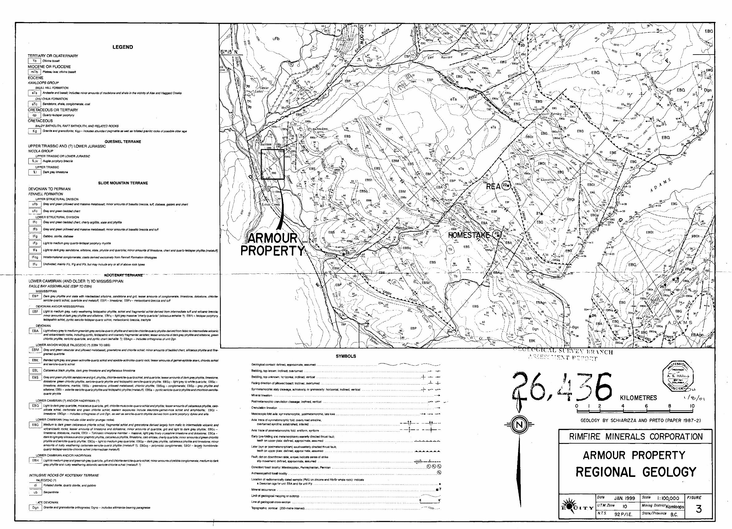
6.0 REGIONAL GEOLOGY
The Armour property lies along the western margin of the Omineca Belt. This portion of the Shuswap Highland is bounded by high grade metamorphic rocks of the Shuswap Complex to the east and rocks of the Intermontane Belt to the west (Schiarizza and Preto, 1987). The regional geology map (Figure 3) has been extracted from Schiariua and Preto’s Figure 4, “Geology of the Adams Plateau - Clearwater - Vavenby Area” (Paper 1987-2).
Bay Assemblage (Units EB) and Fennell Formation (Units UF and IF). The Eagle Bay Assemblage has The area covers a belt of structurally complex, low-grade metamorphic rocks of Paleozoic Eagle
been intruded by Late Devonian orthogneiss (Unit Dgn). The Paleozoic strata are cut by the Cretaceous Rafl and Baldy batholiths (Unit Kg) and Early Tertiary dykes (Unit qp). Eocene sedimentary and volcanic rocks of the Kamloops Group (Units eTc and eTs) and Miocene lavas (Unit Tb) overlie all other units.
The Eagle Bay Assemblage ranges from Early Cambrian to Late Mississippian, and, from oldest to youngest, is comprised of: quartzites and quartzose schists (Unit EBH); mafic metavolcanics and fossiliferous limestone (Unit EBG); grit, phyllite, limestone, chert and metavolcanics (Units EBQ, EBS);
felsic metavolcanic and metasediments (Units EBA, EBF, EBM). The Late Devonian orthogneiss which calcareous phyllite, calc-silicate schist, skarn and mafic metavolcanic rocks (Units EBL, EBK, EBM) and
intrudes Eagle Bay strata is probably related to the felsic volcaniw. The Devonian to Permian Fennell Formation consists of oceanic rocks of the Slide Mountain terrane which have been thrust onto the Eagle Bay Assemblage. The Fennell Formation is thought to be partially coeval with the Eagle Bay Assemblage, forming in a deep oceanic basin an unknown distance to the west (Schiariua and Preto, 1987).
The Paleozoic strata have been separated into four structural slices by southwesterly-directed thrusting and folding. This deformation resulted in the dominant regional schistosity found throughout the area. This fabric has been modified by northwest-trending mesoscopic folds and later west-trending folds. The youngest structures are northeast-trending strike slip faults and later northerly trending faults and associated folds in the Eocene.
The Devono-Mississippian felsic and intermediate metavolcanic rocks of the Eagle Bay Assemblage are host to several Cu-Pb-Zn-Ag-Au-Ba Kuroko-type volcanogenic massive sulphide (VMS) deposits near Adams Lake including the Rea deposit and Homestake prospect (Figure 3). The Rea deposit has an indicated reserve of 376,000 tonnes grading 0.33% Cu, 2.20% Pb, 2.30% Zn, 69.4 g/t Ag and 6.1 g/t Au in two lenses (B.C. Minfile). Silver-lead veins were extracted from the nearby Samatosum Mine on the northern slopes of Samatosum Mountain. The mine operated between May 1989 and September 1992. The Fennell Formation hosts Cyprus-type Cu-Zn-AgAu-Co VMS deposits such as the Chu Chua deposit 25 kilometres north of the Armour property.
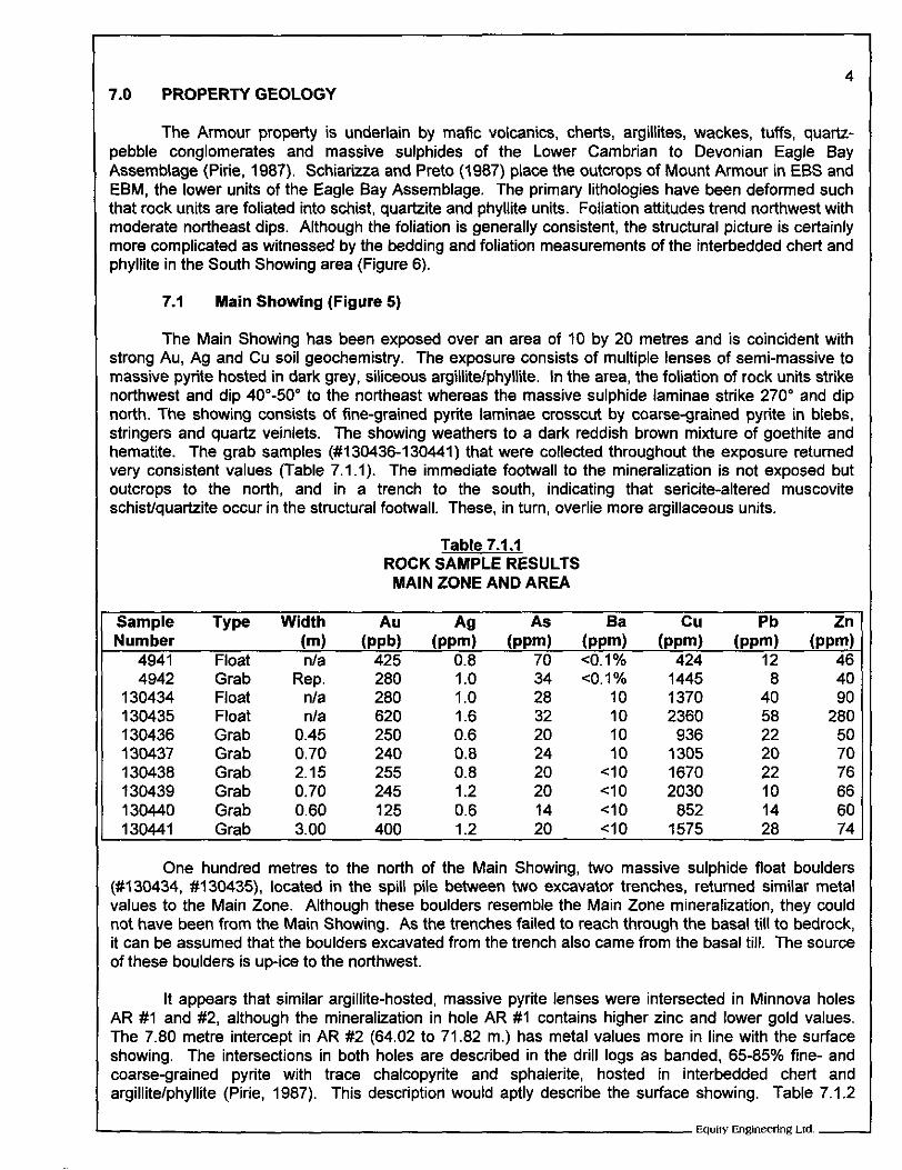
7.0 PROPERTY GEOLOGY 4
The Armour property is underlain by mafic volcanics, cherts, argillites, wackes, tuffs, quartz- pebble conglomerates and massive sulphides of the Lower Cambrian to Devonian Eagle Bay Assemblage (Pine, 1987). Schiariua and Preto (1987) place the outcrops of Mount Armour in EBS and EBM, the lower units of the Eagle Bay Assemblage. The primary lithologies have been deformed such that rock units are foliated into schist, quartzite and phyllite units. Foliation attitudes trend northwest with moderate northeast dips. Although the foliation is generally consistent, the structural picture is certainly more complicated as witnessed by the bedding and foliation measurements of the interbedded chert and phyllite in the South Showing area (Figure 6).
I 7.1 Main Showing (Figure 5)
The Main Showing has been exposed over an area of 10 by 20 metres and is coincident with strong Au, Ag and Cu soil geochemistry. The exposure consists of multiple lenses of semi-massive to massive pyrite hosted in dark grey, siliceous argillite/phyllite. In the area, the foliation of rock units strike northwest and dip 40"-50" to the northeast whereas the massive sulphide laminae strike 270" and dip north. The showing consists of fine-grained pyrite laminae crosscut by coarse-grained pyrite in blebs, stringers and quartz veinlets. The showing weathers to a dark reddish brown mixture of goethite and hematite. The grab samples (#130436-130441) that were collected throughout the exposure returned very consistent values (Table 7.1.1). The immediate footwall to the mineralization is not exposed but outcrops to the north, and in a trench to the south, indicating that sericite-altered muscovite schist/quartzite occur in the structural footwall. These, in turn, overlie more argillaceous units.
ROCK SAMPLE RESULTS Table 7.1.1
MAIN ZONE AND AREA
1 1 Sample Type Width Au AQ As Ba c u Pb Zn
130434 130435 130436 130437 130438 130439 130440
Grab Float Float Grab Grab Grab Grab Grab Grab
Rep. n/a
0.45 nla
0.70 2.15 0.70 0.60 3.00
280 280 620 250 240 255 245 125 400
1 .o 1 .o 1.6 0.6 0.8 0.8 1.2 0.6 1.2
34 28 32 20 24 20 20 14 20
CO. 1 % 10 10 10 10
<IO <IO <IO <IO
1445 1370 2360 936
1305 1670 2030
852 1575
8 40 40 90 58 280 22 50 20 70 22 76 10 66 14 60 28 74
One hundred metres to the north of the Main Showing, two massive sulphide float boulders (#130434, #130435), located in the spill pile between two excavator trenches, returned similar metal values to the Main Zone. Although these boulders resemble the Main Zone mineralization, they could not have been from the Main Showing. As the trenches failed to reach through the basal till to bedrock, it can be assumed that the boulders excavated from the trench also came from the basal till. The source of these boulders is up-ice to the northwest.
It appears that similar argillite-hosted, massive pyrite lenses were intersected in Minnova holes AR # I and #2, although the mineralization in hole AR # I contains higher zinc and lower gold values. The 7.80 metre intercept in AR #2 (64.02 to 71.82 m.) has metal values more in line with the surface showing. The intersections in both holes are described in the drill logs as banded, 65-85% fine- and coarse-grained pyrite with trace chalcopyrite and sphalerite, hosted in interbedded chert and argillitelphyllite (Pirie, 1987). This description would aptly describe the surface showing. Table 7.1.2
1 Eqully Engineering Lld. -
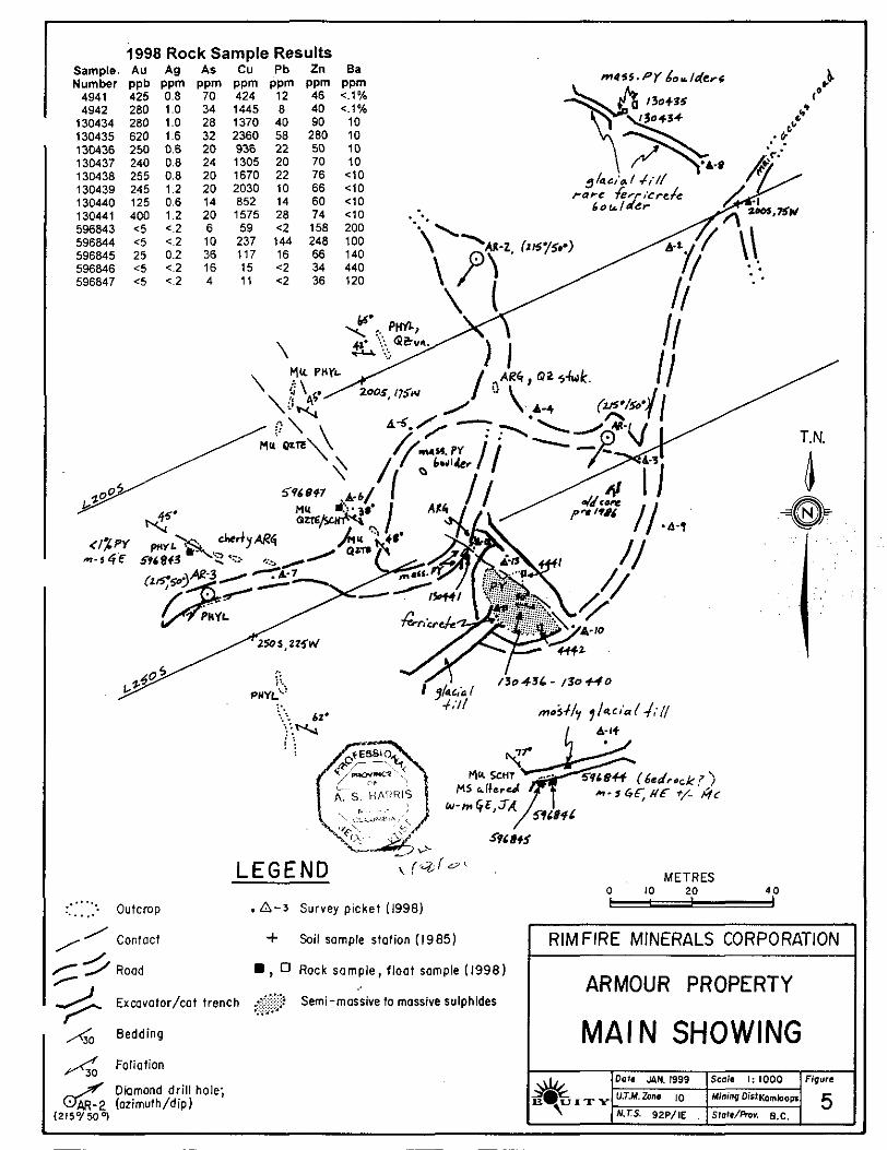
1998 Rock Sample Results Sample. AU Ag As Cu Pb Zn Ba Number ppb ppm ppm ppm ppm ppm ppm 4941 425 0.8 70 424 12 46 <.I% 4942 280 1.0 34 1445 8 40 <.I%
130434 280 1.0 28 1370 40 90 10 130435 620 1.6 32 2360 58 280 10 130436 250 0.6 20 936 22 50 10 130437 240 0.8 24 1305 20 70 10 130438 255 0.8 20 1670 22 76 C 1 0 130439 245 1.2 20 2030 10 66 <IO 130440 125 0.6 14 852 14 60 <IO 130441 400 1.2 20 1575 28 74 4 0 596843 c5 <.2 6 59 c2 158 200 596844 4 c.2 10 237 144 248 100 596845 25 0.2 36 117 16 66 140 596846 <5 <.2 16 15 <2 34 440 596847 <5 c.2 4 1 1 c2 36 120
.. :: L,*
T.N.
: '. Outcrop ..... ..... . A-3 Survey picket (1998)
/ F // Rood
' contoct -k Soil sample station (1985)
5 m , 0 Rock somple , f loat sample (1998)
/ Exmvator/cat trench .&$ Semi-massive to massive sulphides ..
A. Bedding
Foliafion
Diamond drill hole; d" AR-2 (ozlmuth/dip) (215°/500)
~ ~ ~~ ~ ~~~
METRES 0 -
RIMFIRE MINERALS CORPORATION I ARMOUR PROPERTY
MAIN SHOWING I
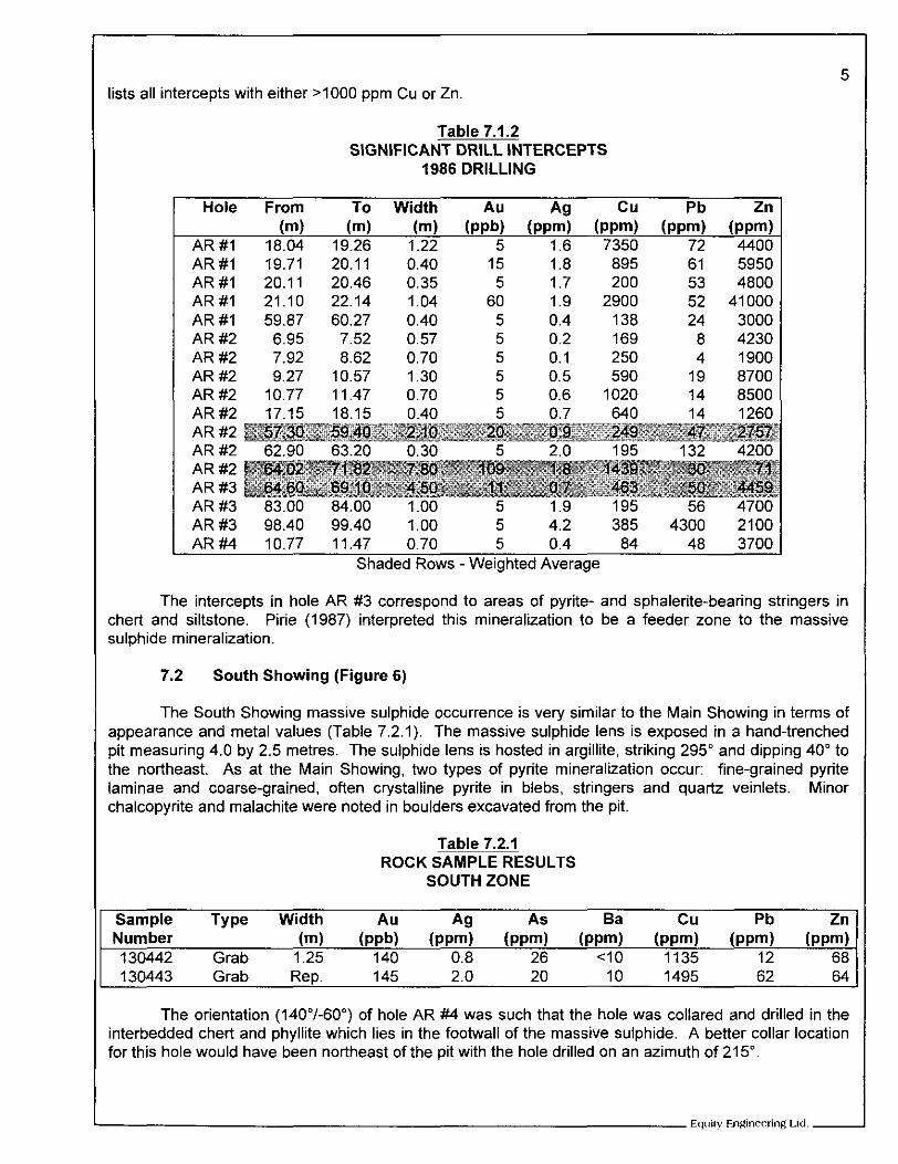
ists all intercepts with either >IO00 ppm Cu or Zn.
SIGNIFICANT DRILL INTERCEPTS Table 7.1.2
1986 DRILLING
Hole From To Width Au c u Pb Zn
AR#I 19.71 20.11 0.40 15 1.8 895 61 AR # I 20.11 20.46 0.35 5 1.7 200 53 AR#I 21.10 22.14 1.04 60 1.9 2900 52 AR#I 59.87 60.27 0.40 5 0.4 138 24 AR#2 6.95 7.52 0.57 5 0.2 169 8 AR#2 7.92 8.62 0.70 5 0.1 250 4 AR #2 9.27 10.57 1.30 5 0.5 590 19 AR#2 10.77 11.47 0.70 5 0.6 1020 14 AR#2 17.15 18.15 0.40 5 0.7 640 14
5950 4800
41 000 3000 4230 1900 8700 8500 1260
AR #2 AR #2 AR #2 AR #3 AR #3 83.00 84.00 1.00 5 1.9 195 56 4700 AR #3 98.40 99.40 1.00 5 4.2 385 4300 2100 AR#4 10.77 11.47 0.70 5 0.4 84 48 3700
Shaded Rows -Weighted Average
5
-
?
i i
-
The intercepts in hole AR #3 correspond to areas of pyrite- and sphalerite-bearing stringers in Zhert and siltstone. Pirie (1987) interpreted this mineralization to be a feeder zone to the massive sulphide mineralization.
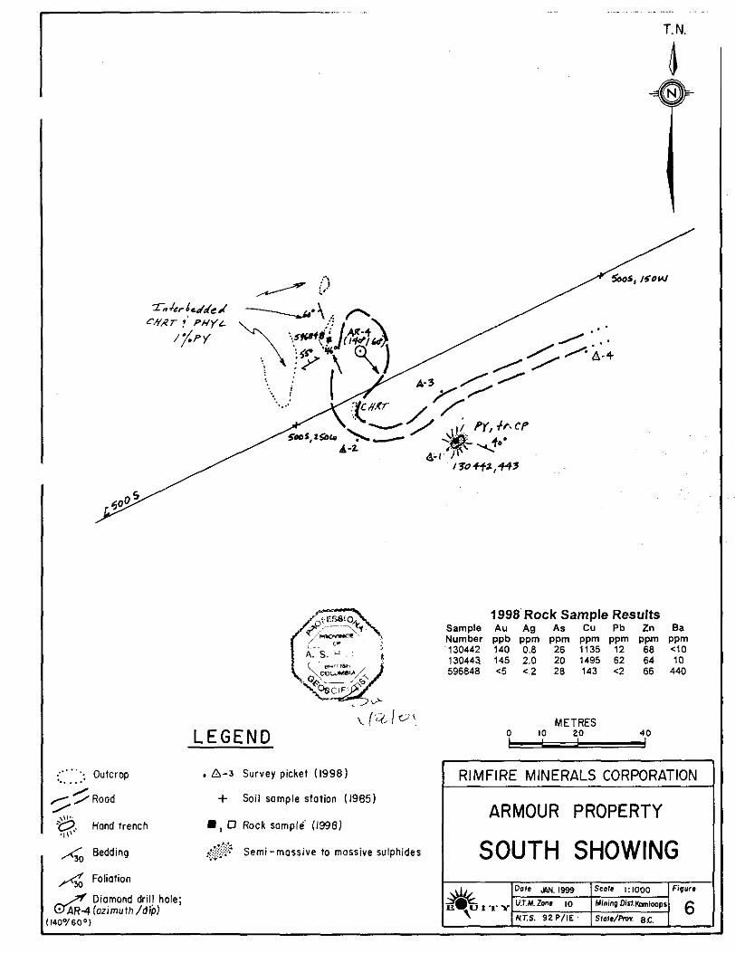
7.2 South Showing (Figure 6)
The South Showing massive sulphide occurrence is very similar to the Main Showing in terms of appearance and metal values (Table 7.2.1). The massive sulphide lens is exposed in a hand-trenched Dit measuring 4.0 by 2.5 metres. The sulphide lens is hosted in argillite, striking 295" and dipping 40" to the northeast. As at the Main Showing, two types of pyrite mineralization occur: fine-grained pyrite aminae and coarse-grained, often crystalline pyrite in blebs, stringers and quartz veinlets. Minor Zhalcopyrite and malachite were noted in boulders excavated from the pit.
ROCK SAMPLE RESULTS Table 7.2.1
SOUTH ZONE
Sample Type Width Au Ag AS Ba c u Pb Zn Number 130442 Grab 1.25 140 0.8 26 4 0 1135 12 68
..
(m) (PPW ( P P d (PPm) (PPW (PPW (PPW (PPm)
130443 Grab Rep. 145 2.0 20 10 1495 62 64
The orientation (140"/-60") of hole AR #4 was such that the hole was collared and drilled in the interbedded chert and phyllite which lies in the footwall of the massive sulphide. A better collar location for this hole would have been northeast of the Dit with the hole drilled on an azimuth of 215".
9 . . .. ~. . . .. . . .. . . ..
T. N.
b
LEGEND
<"'": Outcrop , A 4 Survey picket (1998) .. . . . y /Rood / / .,"" .q. Hand trench D , D Rock sample (1998)
+ Soil sample station (1985)
.I!
h0 Bedding
4 Foliation
<..$$ Semi-massive to mossive sulphides ..
1140°/600)
1998'Rock Sample Results Sample Au Ag As Cu Pb Zn Ba Number ppb Ppm PPm PPm PPm PP PPm 130442 140 0.8 26 1135 12 68 4 0 130441 145 2.0 20 1495 62 64 10 596848 C5 C.2 28 143 C2 66 440
0 10 20 METRES
40
RIMFIRE MINERALS CORPORATION
1 ARMOUR PROPERTY I I SOUTH SHOWING I 1 ". J
6
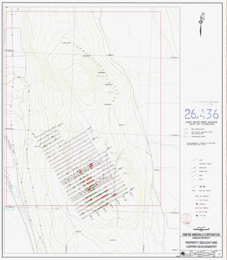
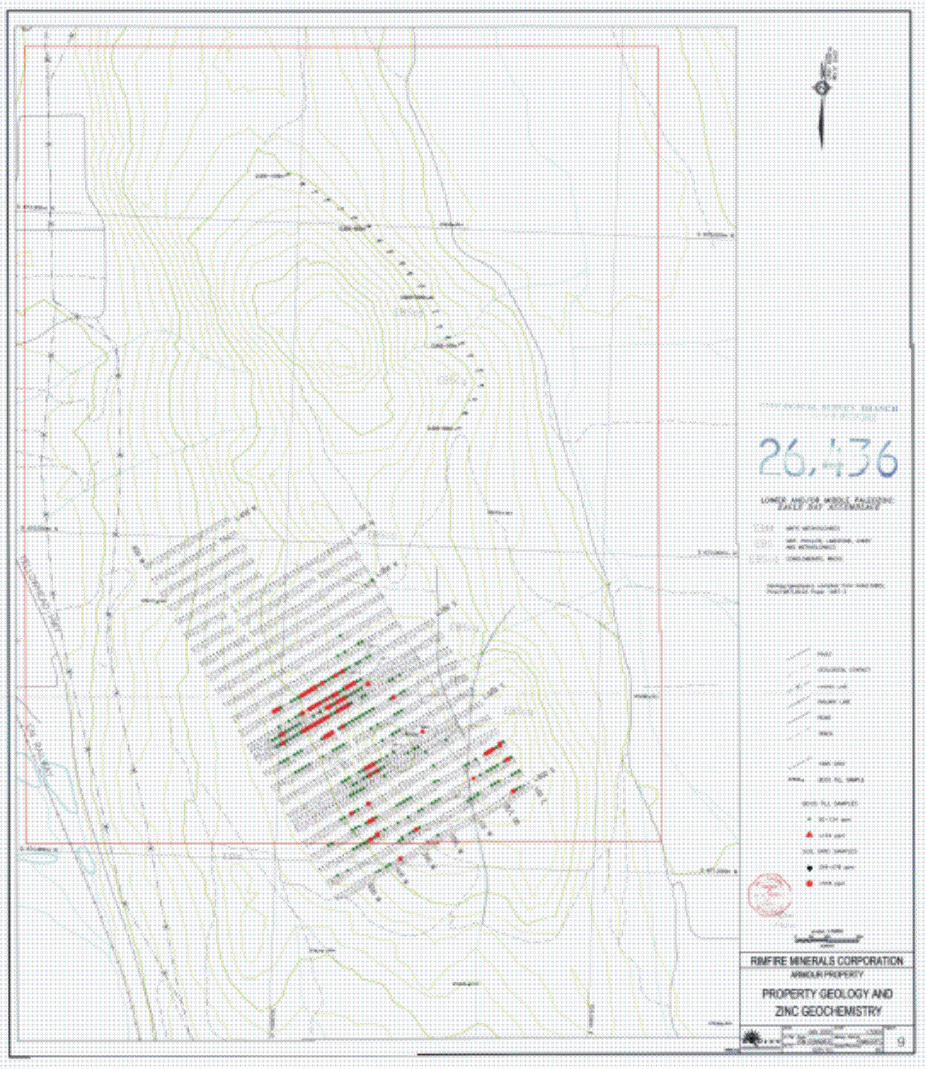
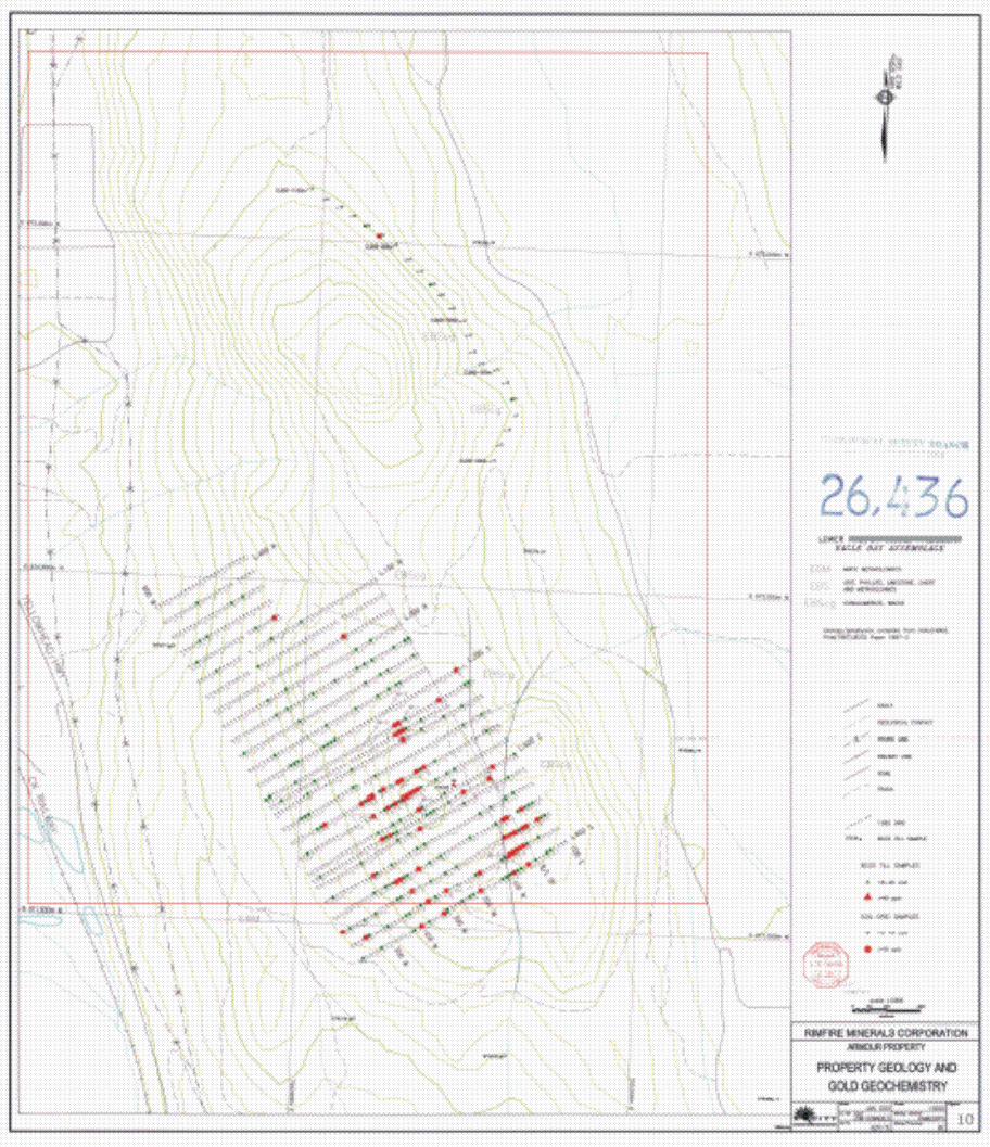
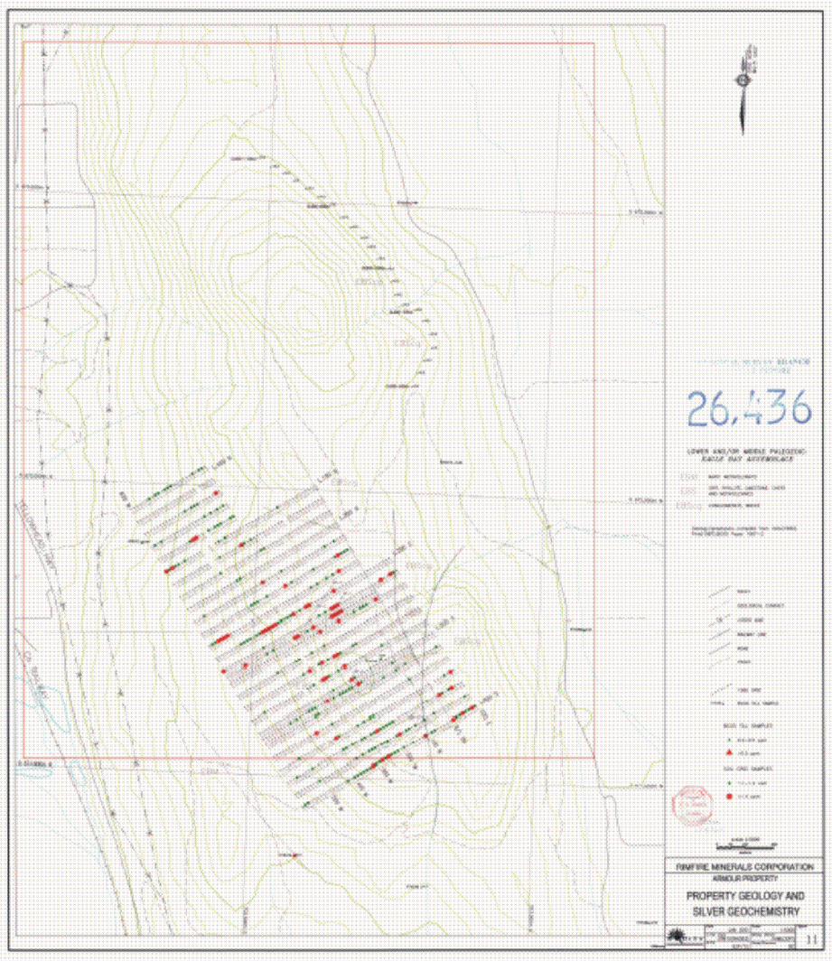
A total of 23 contour soil samples were collected in 2000 along the 600 m.a.s.1. contour in the northeast corner of the property, on the northeast-facing slope of Mount Arrnour. This soil data was compiled with 1985 data to generate plots of soil geochemical data (Figures 7-12). The grade ranges illustrated on these figures correspond to the 80'" and 9!jrn percentiles from this data set (Appendix D). Base metal values obtained from 2000 sampling were all less than the 80rn percentile level, and isolated Au and As values exceeded the 80" percentile level.
The B.C.G.S. conducted a till survey in the summer of 1997; some of these samples were taken on Mount Armour (Bobrowsky et al, 1998). Again, these sample results are shown on their respective elemental plots. The grade ranges selected for the till samples are calculated from data from the 1997 survey (92P/1, 92P18) and a 1996 survey (Bobrowsky et al, 1997) from the adjoining map sheets (82M14, 82M15). The till samples were taken at an average depth of 1.7 metres. Multi-element till anomalies, highlighted by elevated Au, Ag, As, Bi, Cu, Pb, Sb and Zn values, occur in samples taken from the Mount Armour area. The most significant samples are 979256 and 979377, returning the
Ag. Sample #979256 is located 200 metres down-ice from the Main Showing, while sample #979377 highest Zn and Pb values, respectively, from the survey area, as well as highly anomalous Au, As, and
lies west of the showings and must come from another source to the northwest (Bobrowsky et al, 1998). Some of the other anomalies are likely derived from down-ice dispersion from the known occurrences.
The interpretation of the anomalous areas shown from the Falconbridge 1985 survey is affected by down-ice dispersal (NW to SE) if the sample is from basal till covering the rolling topography in the area of the two massive sulphide showings or down slope dispersion if the sampled material is colluvium or colluviated till on steeper side hills. Complicating this interpretation are areas of outcrop or shallow bedrock on the top of Mount Armour where anomalous residual soils indicate source areas in the immediate area of sampling. This is certainly the case of the high Au soil values (L250S, 150W - 2230 ppb) over the Main Showing which pokes through an area of mostly till cover.
Except for some isolated Au, Ag and As values, anomalous soil values are found south of line 150s extending to the southern limits of the survey. The anomalous Cu-Pb-Zn-AuAg soil geochemistry covers an area of 650 by 600 metres and has not been adequately explained by the known mineralization or drilling to date.
1 9.0 DISCUSSION
The Armour Minfile occurrence consists of two massive sulphide showings some 300 metres apart on the top of Mount Armour. Both occurrences are hosted in argillite, and have similar mineralogy (dominantly pyrite), metal suite (Cu-Au) and appearance (both epigenetic and syngenetic sulphides). The presence of massive sulphide boulders in basal till 100 metres north of the Main Showing suggests that this same type of mineralization extends still further to the north. A strongly anomalous RGS till sample in the northwest corner of the grid (#979377) strongly suggests that additional similar mineralization is present further up-ice to the northwest. The mineralization occurs in Unit EBS, a lower member of the Lower Cambrian to Devonian Eagle Bay Assemblage. This mineralization is not likely correlative to the Kuroko-type VMS occurrences in the A d a m Lake area (Rea deposit and Homestake prospect); these showings occur in Unit EBA which is higher in the Eagle Bay Assemblage. In addition, the lack of arsenic and barium values, and the lack of appreciable felsic volcanics differentiates the Armour mineralization from the Adams Lake occurrences. The dominantly sedimentary character of the Armour property would indicate that this mineralization occurs in a more Besshi-type VMS environment.
Previous exploration has shown that the sulphide showings lie within a large Cu-Pb-Zn-AuAg soil anomaly measuring approximately 650 by 600 metres. To date, the only serious drilling campaign, in 1986, has been successful in testing the Main Zone (1.04 m. of 4.1% Zn in AR # I ) but attempts to drill the South Zone (AR #4) and the remainder of the soil geochemistry (AR #3, AR #5) have been largely
EqUily Engineering Lld. -
unsuccessful.
Prior to the next field program, an attempt to secure additional data from lnmet (succ company to MinnovalFalconbridge) should be made. Complete ICP results, geological maps and I of the IP surveys remain outside of the public domain, as they were not filed with government. The drill core, if available, should be located and relogged. Re-establishment of the 1985 grid shol continued in the next program, and, in order to interpret the soil results, detailed terrain and SI geology mapping should be completed over the grid. The grid should be extended to the sout southeast to close off the soil anomalies trending in this direction. Detailed geological mapping more sophisticated electromagnetic survey (Maxmin or UTEM) would better define targets for trer or drilling. It does not appear that prospecting was conducted during the 1970s and 1980s program and hence, prospecting should be incorporated in the next field program, particularly to i( the source of anomalous B.C. R.G.S. till sample #979377, likely west-northwest of the known show
In summary, the Amour property remains largely untested; the limited work to date has fa explain or locate the sources of a significant soil geochemical anomaly within a geological settin has been shown to host syngenetic massive sulphide mineralization. With the excellent a throughout the property, the next phase of exploration will be cost-effective relative to othel projects. The property location, adjacent to power and transportation infrastructure, is ideally situ; a deposit is discovered.
Respectfully submitted,
, .' ? Da . . e 'u leld, P.Geo, .. +*e8
EQUITY ENGINEERING LTb.
, .
I Vancouver. British Columbia January 2001
EQUITY ENGINEERING LTD.

APPENDIX A
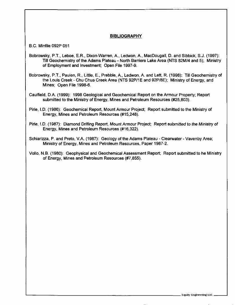
BIBLIOGRAPHY
Equity Engineering Ltd. - .~
BIBLIOGRAPHY
B.C. Minfile 092P 051
Bobrowsky. P.T., Leboe, E.R., Dixon-Warren, A., Ledwon, A., MacDougall. D. and Sibbick, S.J. (1997): Till Geochemistry of the Adams Plateau - North Barriere Lake Area (NTS 82M/4 and 5); Ministry of Employment and Investment; Open File 1997-9.
Bobrowsky, P.T., Paulen. R., Little, E., Prebble, A,, Ledwon, A. and Lett, R. (1998): Till Geochemistry of the Louis Creek - Chu Chua Creek Area (NTS 92Pll E and 92P/8E); Ministry of Energy, and Mines; Open File 1998-6.
Caulfield, D.A. (1999): 1998 Geological and Geochemical Report on the Armour Property; Report submitted to the Ministry of Energy, Mines and Petroleum Resources (#25.803).
Pirie, I.D. (1986): Geochemical Report, Mount Armour Project; Report submitted to the Ministry of Energy, Mines and Petroleum Resources (#15,248).
Pirie, I.D. (1987): Diamond Drilling Report, Mount Armour Project; Report submitted to the Ministry of Energy, Mines and Petroleum Resources (#16,322).
Schiariua, P. and Preto, V.A. (1987): Geology of the Adams Plateau - Clearwater - Vavenby Area; Ministry of Energy, Mines and Petroleum Resources, Paper 1987-2.
Vollo, N.B. (1980): Geophysical and Geochemical Assessment Report; Report submitted to he Ministry of Energy, Mines and Petroleum Resources (#7,855).
APPENDIX B
STATEMENT OF EXPENDITURES
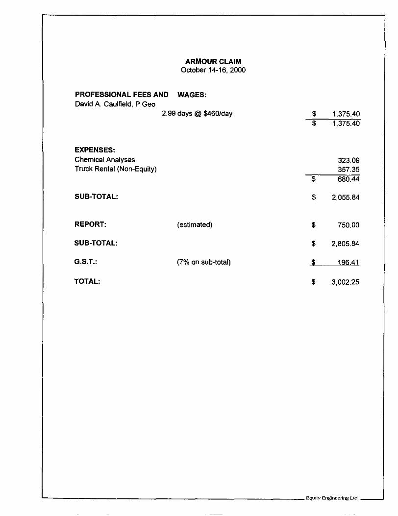
ARMOUR CLAIM October 14-16.2000
PROFESSIONAL FEES AND WAGES: David A. Caulfield, P.Geo
2.99 days @ $460/day
EXPENSES: Chemical Analyses Truck Rental (Non-Equity)
$ 1,375.40 $ 1,375.40
323.09 357.35
$ 680.44
SUB-TOTAL:
REPORT:
SUB-TOTAL:
G.S.T.:
TOTAL:
(estimated)
(7% on sub-total)
$ 2,055.84
5 750.00
$ 2,805.84
$ 196.41
5 3,002.25

APPENDIX C
CERTIFICATES OF ANALYSIS
U
"333
33333 334
""
"Y
Y "
"I"
"
""
V
I I
I nnnnn nnnnn nnnnn nnn
00000 00000 00000 000
nnnnn nnnnn nnnnn nno
APPENDIX D
SOIL SAMPLE STATISTICS
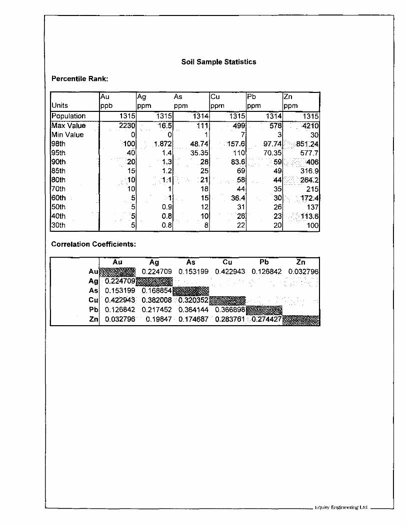
Soil Sample Statistics
Percentile Rank:
Units
Max Value Min Value
85th 80th 70th 60th 50th 40th 30th
U
ppm PPm PPm PPm ppm Pb Zn Pb cu Ag As
1315
~. :406 59. 83.6 28 1.3 20 . 577.7 70.35. 110 35.35 1.4 40
' : ,851.24 97.74 157.6 48.74 1.872 100 30 3 7 1 0 0
-42 1 0 578 499 111 16;5 2230 1315 1314 1315 1314 1315
15 316.9 49 69 25 1.2 10
137 26 31 12 0.9 5 ~ 1'72,4 30 36.4 15 1 5
215 35 44 18 1 10 ,261.2 44 58 21 1 ;I
5 100 20 22 8 0.8 5
. , 113.6 23 26 10 0.8
Correlation Coefficients:
I
APPENDIX E
GEOLOGIST'S CERTIFICATES

GEOLOGIST'S CERTIFICATE
DO HEREBY CERTIFY: I, David A. Caulfield of 3142 Gambier Avenue, Coquitlam, in the Province of British Columbia,
1. THAT I am a Consulting Geologist with offices at Suite 700, 700 West Pender Street, Vancouver, British Columbia.
2. THAT I am a graduate of the University of British Columbia with a Bachelor of Science degree in Geology.
3. THAT I am a Professional Geoscientist registered in good standing with the Association of Professional Engineers and Geoscientists of the Province of British Columbia.
4. THAT this report is based on property work I performed during October 2000, government publications and other publicly available reports.
sh Cdumbia, thisffday of January 2001.
GEOLOGIST'S CERTIFICATE
HEREBY CERTIFY:
1. THAT I am a Consulting Geologist with offices at Suite 700, 700 West Pender
I, Stewart Harris of 20771 44th Avenue, Langley, in the Province of British Columbia, DO
Street, Vancouver, British Columbia.
2. THAT I am a graduate of the University of British Columbia with a Bachelor of Science degree in Geology.
3. THAT I am a Professional Geoscientist registered in good standing with the Association of Professional Engineers and Geoscientists of the Province of British Columbia.
4. THAT this report is based on property work performed during October 2000, government publications and other publicly available reports.
"
DATED at Vancouver, British Columbia, thisgday of January 2001.
i
I 1
I i