2011 annual report for the otay ranch preserve a… · 2011 annual report for the otay ranch...
TRANSCRIPT

2011 Annual Report for the Otay Ranch Preserve
Prepared for Prepared by
City of Chula Vista RECON Environmental, Inc.
276 Fourth Avenue, MSP-101 1927 Fifth Avenue
Chula Vista, CA 91910 San Diego, CA 92101-2358
Contact: Mr. Glen Laube P 619.308.9333 F 619.308.9334
RECON Number 5256
January 23, 2011
Cailin O’Meara, Biologist
Anna Bennett, Biologist
Mark Dodero, Senior Biologist

2011 Annual Report for Otay Ranch Preserve
TABLE OF CONTENTS
1.0 Introduction 1
1.1 Project Description 1
1.2 Purpose 5
2.0 Resource Management Plans 5
2.1 Phase 1 Resource Management Plan 6
2.2 Phase 2 Resource Management Plan 6
3.0 POM and PSB Responsibilities 7
4.0 Tasks Performed: January 1, 2011–June 30, 2011 7
4.1 2011 Quarterly Reports 7
4.2 2011 Baseline Survey Reports 8
5.0 Tasks Performed: July 1, 2011–December 31, 2011 9
5.1 Cease Work 9
5.2 Salt Creek 9
5.2.1 Methods 9 5.2.2 Results and Discussion 14
5.3 San Ysidro 22
5.3.1 Methods 25 5.3.2 Results/Discussion 26
5.4 Meetings and Coordination 26
5.5 FY 2011–12 Tasks 26
6.0 References Cited 29
2011 Annual Report for Otay Ranch Preserve
TABLE OF CONTENTS (CONT.)
FIGURES
1: Regional Location of Conveyed Otay Ranch Preserve Land 2 2: Location of Conveyed Otay Ranch Preserve Land 3 3: Location of Conveyed Otay Ranch Preserve Land on Aerial Map 4 4: Public Access Issues at Salt Creek Parcels 18 5: Spreading Navarretia (Navarretia fossalis) Location at Salt Creek Parcels 21 6: Perennial Pepperweed (Lepidium latifolium) Locations at Salt Creek Parcels 23 7: Least Bell’s Vireo Locations at Salt Creek Parcels 24 8: Public Access Issues at San Ysidro Parcels 27
TABLE
1: Preserve Parcels, APN Numbers, and Acreages 5
PHOTOGRAPHS
1: Quino Checkerspot Butterfly, McMillin Parcels 10 2: RECON Crew Spraying Herbicide on Stinkwort, Salt Creek Parcels 12 3: Damage to Eastern Boundary Fence prior to Repair, Salt Creek Parcels 13 4: Cut Wire along Eastern Boundary Fence prior to Repair, Salt Creek Parcels 16 5: Repaired Fence along Eastern Boundary, Salt Creek Parcels 16 6: Purslane Speedwell in a Vernal Swale, Salt Creek Parcels 17 7: Water-starwort and Treefrog in a Vernal Swale, Salt Creek Parcels 19 8: Garden Lippia in a Vernal Swale, Salt Creek Parcels 20 9: Stinkwort Several Weeks after Being Treated with Herbicide, Salt Creek Parcels 20 10: Giant Water Bug Eating a Treefrog, San Ysidro Parcels 28
ATTACHMENTS
1: Tasks Performed: July 1 through December 31, 2011 at Otay Ranch Preserve 2: Previously Undocumented Plant Species Observed in Salt Creek Parcels. 3: Previously Undocumented Wildlife Species Observed in Salt Creek Parcels. 4: Previously Undocumented Sensitive Plant Species Observed in Salt Creek Parcels. 5: Previously Undocumented Sensitive Wildlife Species Observed in Salt Creek Parcels. 6: Previously Undocumented Wildlife Species Observed in San Ysidro Parcels.

2011 Annual Report for Otay Ranch Preserve
Page 1
1.0 Introduction
This annual report describes the methods and results of management and monitoring tasks that were conducted from January 1, 2011 to December 31, 2011 at the Otay Ranch Preserve (Preserve) by RECON Environmental, Inc. (RECON) as the Preserve Steward/Biologist (PSB). Management and monitoring activities included site visits to perform land stewardship tasks; general and focused biological surveys; meeting and presentation attendance; coordination with land managers; and report and work plan preparation and submittal.
Two 2011 quarterly reports were previously submitted to the Preserve Owner/Manager (POM). The first 2011 quarterly report described management and monitoring activities that occurred from January 1, 2011 through March 31, 2011 (RECON 2011a); The second 2011 quarterly report described management and monitoring activities that occurred from April 1, 2011 through June 30, 2011 (RECON 2011b). Additionally, three baseline survey reports were previously submitted to the POM detailing methods and results of baseline surveys conducted in 2011 at the Jamul Mountains, Dulzura, Northern San Ysidro, McMillin, and Little Cedar Canyon parcel sets (RECON 2012a, 2012b, and 2012c).
This 2011 annual report summarizes work performed from January 1, 2011 through June 30, 2011 which was previously described in detail in the 2011 quarterly and baseline survey reports. Activities that occurred between July 1, 2011 and December 31, 2011 have not been described in previously submitted reports and are discussed in detail in this 2011 annual report.
1.1 Project Description
The Preserve is located in southwestern San Diego County and is composed of three major parcels: Otay River parcel, Proctor Valley parcel, and San Ysidro Mountains parcel (County of San Diego 1993). The Preserve boundaries include lands within the city of Chula Vista (City) and the County of San Diego (County). During the time frame of this report (January 2011 through December 2011), lands that have been conveyed to the Preserve include the Jamul Mountains, Dulzura, Little Cedar Canyon, McMillin, San Ysidro, Northern San Ysidro, and Salt Creek parcels (Figures 1-3). Table 1 lists the associated Assessor’s Parcel Numbers (APN) and acreages for each of the parcels.

FIGURE 1Regional Location of Conveyed
Otay Ranch Preserve Land
Dulzura
Jamul
Jamacha
BlossomValley
SanDiego
SanDiego
ImperialBeach
Coronado
LakePoway
LaJolla
Brown Field
RanchoPenasquitos
CarmelValley
LindberghFieldAirport
MCAS Miramar
MiramarReservoir
SolanaBeach
DelMar
MissionBay
SanDiegoBay
SweetwaterReservoir
Lower OtayReservoir
ElCapitanReservoir
SanVicenteReservoir
Santee
LemonGrove
El Cajon
Poway
LaMesa
NationalCity
SanDiego
Chula Vista
UNINCORPORATED
PacificOcean
C A L I F O R NI A
M E X I C O
§̈¦15
£¤67
Poway Road
Via d
elaValle
£¤56
§̈¦5
§̈¦805
£¤52
§̈¦8
£¤94
£¤94
£¤125
M:\JOBS3\5256\common_gis\fig1_annrpt_2012.mxd 1/5/2012
0 4Miles [
Otay Ranch Preserve Parcels

FIGURE 2
Location of Conveyed Otay Ranch Preserve Land
Little Cedar Canyon
Dulzura
Jamul Mountains
McMillin
Northern San Ysidro
64706001
59817004
59807006
64705004
59816014
64711001
64709004
64710008
64710010
59807005
64712001
San Ysidro
Salt Creek
Little Cedar Canyon
Dulzura
Jamul Mountains
McMillin
Northern San Ysidro
64706001
59817004
59807006
64705004
59816014
64711001
64709004
64710008
64710010
59807005
64712001
San Ysidro
Salt Creek
M:\JOBS3\5256\common_gis\fig2_annrpt_2012.mxd 1/5/2012
0 3,000Feet
Map Source: USGS 7.5 minute topographic map series, DULZURA, JAMUL MOUNTAINS, OTAY MOUNTAINS & OTAY MESA quadrangles, OTAY (ESTUDILLO) Landgrant, T17S R01E, T18S R01E
[
Otay Ranch Preserve Parcels

FIGURE 3
Location of Conveyed Otay Ranch Preserve Land on Aerial Map
Dulzura
McMillin
Jamul Mountains
Little Cedar Canyon
Northern San Ysidro
64706001
59817004
59807006
64705004
59816014
64711001
64709004
64710008
64710010
59807005
64712001
San Ysidro
Salt Creek
O TA Y
L AK
ESRD
HUNTE
PY
W I L EY R
D
EASTLAKEPY
WUESTERD
O L YM P
I CPY
SR-125NB
SR-125SB
O T A Y M T N T T
LANEAV
WOODSDR
C L U B H O US E D R
B I R C HR D
R O U T E9
F EN T
O N S T
CROSSRO
ADSST
SGREE
NS V
I EW D R
DUNCANRANCH
RD
L AC O S T A
A
V
NGRE E N S V I E
WDR
P R O C T O R V A L L E Y R D
SR-125NB
M:\JOBS3\5256\common_gis\fig3_annrpt_2012.mxd 1/5/2012
0 3,000Feet
Image Source: Copyright 2010 AerialsExpress (flown Feb 2010)
[
Otay Ranch Preserve Parcels
2011 Annual Report for Otay Ranch Preserve
Page 5
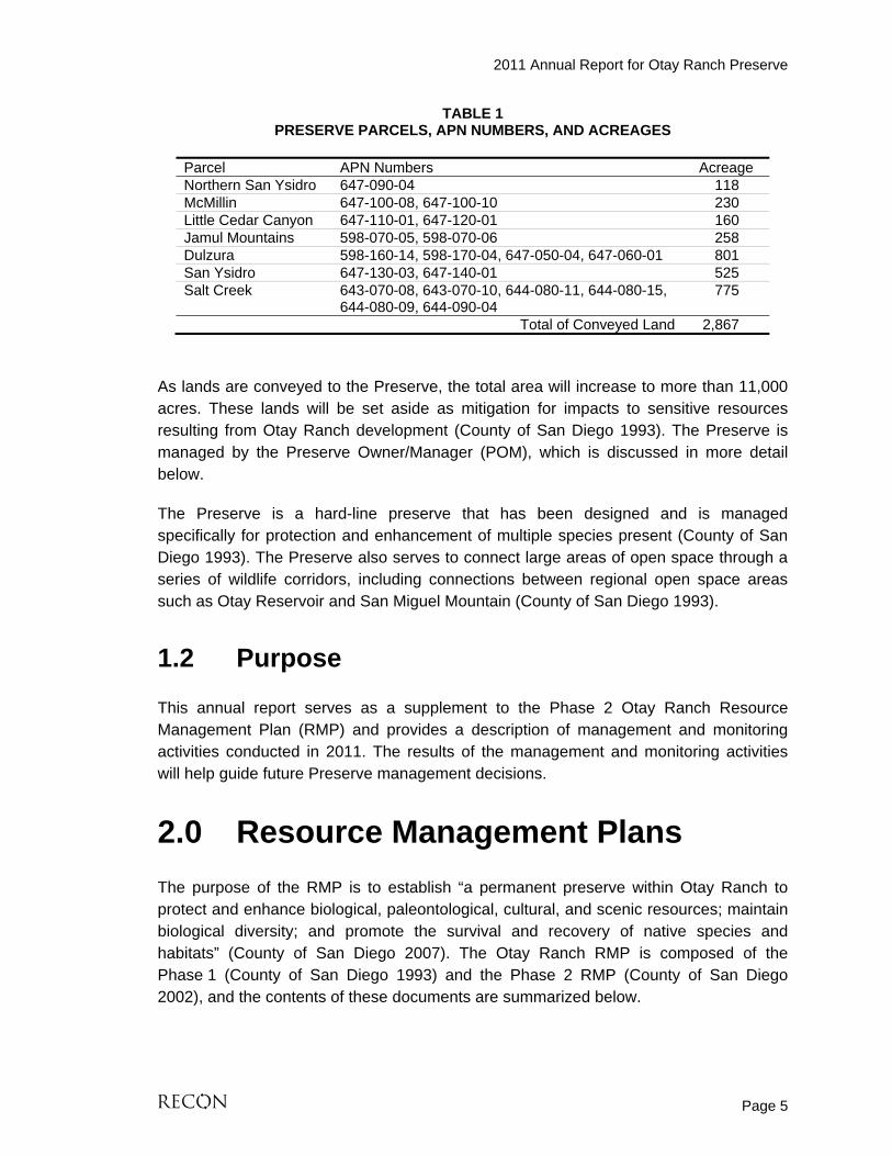
TABLE 1 PRESERVE PARCELS, APN NUMBERS, AND ACREAGES
Parcel APN Numbers Acreage Northern San Ysidro 647-090-04 118 McMillin 647-100-08, 647-100-10 230 Little Cedar Canyon 647-110-01, 647-120-01 160 Jamul Mountains 598-070-05, 598-070-06 258 Dulzura 598-160-14, 598-170-04, 647-050-04, 647-060-01 801 San Ysidro 647-130-03, 647-140-01 525 Salt Creek 643-070-08, 643-070-10, 644-080-11, 644-080-15,
644-080-09, 644-090-04 775
Total of Conveyed Land 2,867
As lands are conveyed to the Preserve, the total area will increase to more than 11,000 acres. These lands will be set aside as mitigation for impacts to sensitive resources resulting from Otay Ranch development (County of San Diego 1993). The Preserve is managed by the Preserve Owner/Manager (POM), which is discussed in more detail below.
The Preserve is a hard-line preserve that has been designed and is managed specifically for protection and enhancement of multiple species present (County of San Diego 1993). The Preserve also serves to connect large areas of open space through a series of wildlife corridors, including connections between regional open space areas such as Otay Reservoir and San Miguel Mountain (County of San Diego 1993).
1.2 Purpose
This annual report serves as a supplement to the Phase 2 Otay Ranch Resource Management Plan (RMP) and provides a description of management and monitoring activities conducted in 2011. The results of the management and monitoring activities will help guide future Preserve management decisions.
2.0 Resource Management Plans
The purpose of the RMP is to establish “a permanent preserve within Otay Ranch to protect and enhance biological, paleontological, cultural, and scenic resources; maintain biological diversity; and promote the survival and recovery of native species and habitats” (County of San Diego 2007). The Otay Ranch RMP is composed of the Phase 1 (County of San Diego 1993) and the Phase 2 RMP (County of San Diego 2002), and the contents of these documents are summarized below.

2011 Annual Report for Otay Ranch Preserve
Page 6
2.1 Phase 1 Resource Management Plan
The primary purpose of the Phase 1 RMP is to serve as the functional equivalent of the County Resource Protection Ordinance (RPO) (County of San Diego 2002). The goal of the RPO is “to increase the preservation and protection of the County’s unique topography, natural beauty, diversity, and natural resources” (RPO Article I). The planning context of the RMP and RPO are summarized in the Phase 1 RMP (County of San Diego 2002). As summarized in the Phase 2 RMP (County of San Diego 2002), the Phase 1 RMP is to serve as a comprehensive plan to manage, enhance, and preserve sensitive, natural, and cultural resources within the Preserve. The Phase 1 RMP was adopted by the County and City concurrently with the enactment of the Otay Ranch General Development Plan (GDP).
The Phase 1 RMP identifies an open space system as a permanent 11,375-acre Preserve dedicated to the protection and enhancement of the multiple resources present on Otay Ranch.
2.2 Phase 2 Resource Management Plan
The Phase 1 RMP is to be implemented through the Phase 2 RMP. Unlike the Phase 1 RMP, the Otay Ranch Phase 2 RMP is a process rather than a single plan or document (County of San Diego 2002). The Phase 2 RMP encompasses a series of tasks that must be performed over time throughout implementation of the Otay Ranch GDP (County of San 2002). Some of the Phase 2 RMP tasks are fully satisfied upon the completion of a single study or the creation of a plan, while other tasks must be completed as a condition of approval of subsequent Otay Ranch Sectional Planning Areas. Other Phase 2 RMP tasks, such as the Biota Monitoring Program, must be performed over time, even if there are no pending discretionary actions (County of San Diego 2002).
A comprehensive monitoring program for the Preserve is to be developed in conjunction with the Phase 2 RMP (County of San Diego 2002). In addition, an annual monitoring program is to be developed and designed to detect changes in quality and quantity of on-site biological resources, such as sensitive wildlife and plant species, and sensitive habitat.
Four of the Phase 2 RMP studies were completed prior to adoption of the original Otay Ranch GDP. These studies include: a vernal pool study, a wildlife corridor study, a raptor study, and resource identification and mapping (County of San Diego 2002). In addition, a cultural resources systematic survey was completed as part of the Phase 2 RMP (County of San Diego 2002). Tasks that require a continuing commitment to implementation include, but are not limited to, ongoing studies for the coastal California

2011 Annual Report for Otay Ranch Preserve
Page 7
gnatcatcher (CAGN, Polioptila californica californica) and coastal cactus wren (CACW, Campylorhynchus brunneicapillus) (County of San Diego 2002).
3.0 POM and PSB Responsibilities
In 1996, the San Diego County Board of Supervisors authorized the formation of a POM (County of San Diego 2010). At this time, the City and County form the POM (County of San Diego 2007). The POM is responsible for a number of tasks including management of resources, restoration of habitat, and enforcement of open space restrictions for the Preserve (County of San Diego 2010).
In 2009, RECON was contracted to serve as the PSB. The PSB’s role is to perform basic stewardship and conduct required biological surveys and monitoring for the Preserve (Otay Ranch 2009). Responsibilities of the POM and PSB are detailed in the FY 2009-10 annual report and FY 2010-11 annual work plan (RECON 2011d and 2011e).
4.0 Tasks Performed: January 1, 2011–June 30, 2011
This section summarizes the 2011 quarterly and baseline survey reports that have already been submitted to the POM in 2011 (RECON 2011a, 2011b, 2012a, 2012b, 2012c). Two quarterly reports have been submitted to the POM that detail activities that took place between January 1, 2011 and June 30, 2011 (RECON 2011a and 2011b). Three additional baseline survey reports have also been submitted to the POM detailing methods and results of baseline surveys conducted in 2011 at the Jamul Mountains, Dulzura, Northern San Ysidro, McMillin, and Little Cedar Canyon parcel sets (RECON 2012a, 2012b, and 2012c).
4.1 2011 Quarterly Reports
This section describes all management and monitoring tasks at the Preserve that were described in the January 1 through March 31, 2011 and April 1 through June 30, 2011 quarterly reports (RECON 2011a and RECON 2011b).
Quarterly Report: January 1, 2011 through March 31, 2011
Management and monitoring tasks performed at the Salt Creek and San Ysidro parcels from January 1, 2011 through March 31, 2011 include reconnaissance site visits to document access issues, illegal dumping, and previously undocumented flora and fauna.

2011 Annual Report for Otay Ranch Preserve
Page 8
Additional tasks performed included: preparation and presentation of the PowerPoint presentation entitled Otay Ranch Preserve Prioritizing Survey, Monitoring, and Maintenance Tasks for the January San Diego Management and Monitoring Program (SDMMP) Meeting, coordinating with POM to obtain information regarding newly conveyed lands and budget issues to be incorporated into the Fiscal Year (FY) 2010–11 Work Plan, PowerPoint presentation of the Annual Report Summary for CDFG and U.S. Fish and Wildlife Service (USFWS) at the CDFG offices, finalizing the FY 2010–11 Work Plan, finalizing the FY 2009–10 Annual Report, and SDMMP and South County Land Manager (SCLM) meeting attendance.
Quarterly Report: April 1, 2011 through June 30, 2011
Regularly scheduled site visits were conducted from April 1, 2011 through June 30, 2011 at the Salt Creek and San Ysidro parcels to document access issues, illegal dumping, and previously undocumented flora and fauna. Additional management and monitoring tasks performed at the Salt Creek parcels from April 1, 2011 through June 30, 2011 include fence repairs, invasive plant treatment, and least Bell’s vireo (Vireo bellii pusillus) surveys. Additional tasks performed included assisting the POM with the preparation of the MSCP Annual Meeting presentation, SDMMP, SCLM, and MSCP meeting attendance, PowerPoint presentation of the Annual Report Summary POM Preserve Management Team Meeting, PowerPoint presentation of the Annual Report Summary POM Policy Committee, attending a CACW symposium hosted by The Nature Reserve of Orange County and The Nature Conservancy, writing and submitting the first, second, and third quarterly reports for FY 2010–11 and FY 2011–12 preliminary draft work plan to the POM.
4.2 2011 Baseline Survey Reports
RECON biologists conducted surveys to gather baseline biological information at the Dulzura, Jamul Mountains, Northern San Ysidro, McMillin, and Little Cedar Canyon parcels during the spring and summer of 2011 (RECON 2012a, 2012b, 2012c). The surveys consisted of vegetation mapping and general plant and wildlife surveys. Sensitive species were observed incidentally, and suitable habitat for sensitive wildlife species was also evaluated during general surveys. Topography, soils, drainages, wildlife movement corridors, and access issues were also evaluated during baseline surveys.
The baseline data gathered during these surveys will be used to guide future prioritization of preserve management actions. Future focused surveys for Quino checkerspot butterfly (Euphydryas editha quino), as well as permanent photo point monitoring, have been recommended as tasks for all parcels surveyed in the Draft FY

2011 Annual Report for Otay Ranch Preserve
Page 9
2011–12 Annual Work Plan for Conveyed Lands Managed by the Otay Ranch POM ([2011–2012 Work Plan]; RECON 2011c) (Photograph 1).
5.0 Tasks Performed: July 1, 2011–December 31, 2011
This section provides details of work performed from July 1, 2011 through December 31, 2011 which have not been described in previously submitted reports.
5.1 Cease Work
As requested by the POM, the PSB ceased work starting September 2, 2011 through October 27, 2011. Management and monitoring tasks did not occur between these dates.
5.2 Salt Creek
The following sections describe the methods and results of management and monitoring tasks that were performed at the Salt Creek parcels from July 1, 2011 to December 31, 2011. Attachment 1 provides a list of tasks performed between July 1, 2011 and December 31, 2011.
5.2.1 Methods
5.2.1.1 Regularly Scheduled Site Visits
RECON personnel conducted regularly scheduled visits to the Salt Creek parcels approximately every other week. The purpose of the site visits was to document any access issues, illegal dumping, new species, weeds, and the overall health of the Salt Creek parcels. Site visits occurred on varying weekdays and times to observe possible trespassing issues during a broad range of time. Access issues, illegal dumping, and newly documented flora and fauna are discussed separately in Section 6.2, Results and Discussion.
5.2.1.2 Flora
Previously undocumented invasive, non-sensitive, and rare plant species were recorded during regularly scheduled site visits and the species lists were revised accordingly. Floral nomenclature for species follows that which is specified in the Jepson Online

M:\JOBS3\5256\bio\graphics\annrpt_2011\photos.indd 01/20/12
Quino Checkerspot Butterfl y, McMillin ParcelsPHOTOGRAPH 1

2011 Annual Report for Otay Ranch Preserve
Page 11
Interchange (JFP 2011). Species that could not be readily identified in the field were collected and identified using a taxonomic key.
5.2.1.2.1 Rare Plants
Any incidental sightings of rare plant species were recorded during regularly scheduled site visits. Sensitive plant species identified were mapped using a hand held Trimble® Global Position System (GPS) unit, and the species lists were revised accordingly. Assessments of the sensitivity of plant species are based primarily on State of California (2011a, 2011b), City of Chula Vista (2003), and CNPS (2011). Focused rare plant surveys were not conducted during 2011.
5.2.1.2.2 Invasive Plant Species
Priority for treating invasive species was based on several criteria (in no specific order): Early Detection Rapid Response (EDRR), California Invasive Plant Council (Cal-IPC) ratings, feasibility of successful control, and threat to sensitive species. All four of these factors were taken into consideration when determining treatment priority for invasive species.
Stinkwort (Dittrichia graveolens) was the only species of priority of control in 2011. As described in the April 1, 2011 through June 30, 2011 quarterly report, RECON certified herbicide applicators implemented weed abatement under the supervision of the PSB in June 2011 (RECON 2011b; Photograph 2). Applications of glyphosate based herbicide were used to control stinkwort. Follow-up monitoring by RECON biologists took place after weed abatement was implemented to determine if the control methods were effective (Photograph 3). After herbicide treatment, monitoring for stinkwort was conducted approximately once every two weeks to determine if additional herbicide treatment or pulling individuals by hand was required. Hand-weeding of individuals was performed in July and August.
Perennial pepperweed (Lepidium latifolium) was identified and mapped by PSB Anna Bennett and Cailin O’Meara in late August 2011. PSB Mark Dodero and Anna Bennett met San Diego County Senior Agricultural/Standards Inspector, Bill Winnans, regarding efforts to control the species on August 26, 2011.
5.2.1.3 Fauna
Previously undocumented wildlife species were recorded during regularly scheduled site visits and species lists revised accordingly. All animal species were observed visually or detected from calls, tracks, scat, or nests. Zoological nomenclature for invertebrates is in accordance with Mattoni (1990) and Opler et al. (1999); for reptiles with Crother (2001, 2008); for birds with the American Ornithologists’ Union Checklist (1998) and Unitt (1984, 2004); and for mammals with Baker et al. (2003) and Hall (1981). Assessments

M:\JOBS3\5256\bio\graphics\annrpt_2011\photos.indd 01/20/12
RECON Crew Spraying Herbicide on Stinkwort, Salt Creek Parcels
PHOTOGRAPH 2

M:\JOBS3\5256\bio\graphics\annrpt_2011\photos.indd 01/20/12
Stinkwort Several Weeks After Being Treated with Herbicide, Salt Creek Parcels
PHOTOGRAPH 3

2011 Annual Report for Otay Ranch Preserve
Page 14
of the sensitivity of wildlife species are based primarily on State of California (2011c, 2011d) and City of Chula Vista (2003). Focused LBV surveys were completed in July 2011 and are discussed in more detail below.
5.2.1.3.1 Least Bell’s vireo
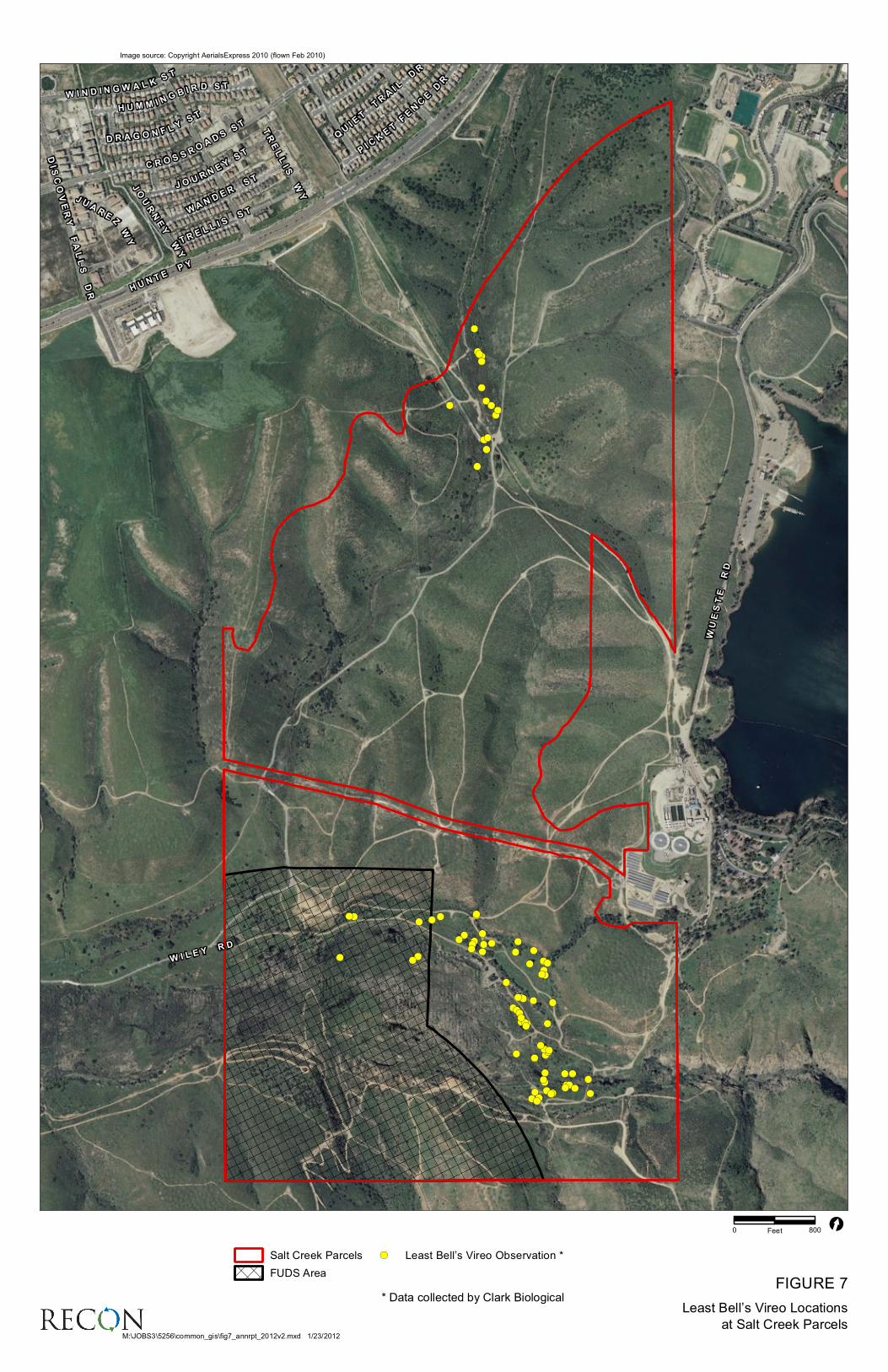
LBV is a federally and state-listed endangered species and is specified as a biological resource to be monitored in the Phase 2 RMP through the Biota Monitoring Program (County of San Diego 2002). Least Bell’s vireo surveys and nest monitoring were conducted April through June of 2011 on all suitable habitat in the Salt Creek parcels by Kevin Clark of Clark Biological Services under USFWS 10(a)1(A) permit TE-117947-3 and were completed in July 2011 (Clark 2011; RECON 2011b).
Least Bell’s vireo surveys followed protocol established by USFWS least Bell’s vireo survey guidelines (USFWS 2001). Surveys were conducted on all suitable habitat, except for Formerly Used Defense Sites (FUDS) areas. Vireos that were heard singing within the FUDS area were mapped but monitoring was not conducted. Surveys were performed eight times during the nesting season, at least 10 days apart to maximize detection. Data pertaining to LBV status and distribution was recorded. All LBV were also assessed for the presence of leg-bands as a part of ongoing data collection efforts conducted by the U.S. Geological Survey and USFWS in southern California.
All LBV nests were monitored on a weekly to bi-weekly basis to determine status and check the nests for parasitism by brown-headed cowbirds (Molothrus ater). Additionally, all avian species detected during surveys were recorded. The results of the surveys were submitted by Clark Biological Services to RECON and are summarized in Section 5.2.2.2.2.1 of this report.
5.2.2 Results and Discussion
5.2.2.1 Regularly Scheduled Site Visits
Regularly scheduled site visits were conducted to document access issues, illegal dumping, and previously undocumented flora and fauna. The results of these site visits are discussed in detail below.
5.2.2.1.1 Access Issues
Issues of fence and gate integrity were identified by the PSB during bi-weekly site visits. Signs of trespassing throughout the Preserve included the formation of new roads and trails, and tracks from vehicles and mountain bikes.
Evidence of trespassing by foot, mountain bikes, and vehicles has been observed along the eastern border of the Salt Creek parcels off of Wueste Road. The PSB observed

2011 Annual Report for Otay Ranch Preserve
Page 15
multiple instances of damages to the fence during site visits. Most notably, an illegal vehicle access road was created by an opening in the perimeter fencing (Photographs 4 through 6). Approximately 145 linear feet of fencing was repaired along the eastern boundary at Salt Creek in June 2011. Details of this repair are provided in the April 1, 2011 and June 30, 2011 quarterly report (RECON 2011b). Minor fence repairs were also made in July and August (Figure 4).
5.2.2.1.2 Illegal Dumping
No new illegal dumping sites were observed during site visits in 2011. Discarded old clothes, backpacks, and water bottles are occasionally found scattered around the Preserve. The PSB shall remove the trash at both the southern boundary location and the abandoned vagrant camp in FY 2011–2012.
5.2.2.2 Newly Documented Flora and Fauna
Previously undocumented rare, invasive and non-sensitive plant and wildlife species were documented during regularly scheduled site visits in the Salt Creek parcels. Nine previously undocumented plant species and 16 previously undocumented wildlife species were recorded in 2011. Of these, 1 wildlife species is considered sensitive, 1 plant species is considered sensitive, and 1 plant species is considered invasive. These species are discussed in detail below. Several previously undocumented plant species are shown in Photographs 7 through 9. Lists of previously undocumented plant and wildlife species observed in 2011 are shown in Attachments 2 through 5.
5.2.2.2.1 Flora
a. MSCP Covered Species
One previously undocumented sensitive plant species, spreading navarretia (Navarretia fossalis), was documented in the Salt Creek parcels during 2011. Spreading navarretia is an MSCP covered species, is federally listed as threatened, and has a CNPS ranking of 1B.1 (rare, threatened, or endangered in California and elsewhere; seriously endangered in California) (State of California 2011a, 2011c; City of Chula Vista 2003; CNPS 2010). This species was documented in a vernal pool swale habitat located adjacent to the Otay River in the Salt Creek parcels (Figure 5). Fewer than 10 individuals were observed at one location. Additional individuals of spreading navarretia may occur in other vernal pool swale habitat at the Salt Creek parcels.
b. Invasive Plant Species
Following the EDRR method and a Cal-IPC moderate (alert) rating, stinkwort is a high-priority species for management at the Salt Creek parcels because the populations of this species are still relatively small. In July and August, concentrations of stinkwort were

PHOTOGRAPH 4Damage to Eastern Boundary Fence Prior to Repair, Salt Creek Parcels
Cut Wire Along Eastern Boundary Fence Prior to Repair, Salt Creek Parcels
PHOTOGRAPH 5
M:\JOBS3\5256\bio\graphics\annrpt_2011\photos.indd 01/20/12

M:\JOBS3\5256\bio\graphics\annrpt_2011\photos.indd 01/20/12
Repaired Fence Along Eastern Boundary, Salt Creek Parcels
PHOTOGRAPH 6

FIGURE 4Public Access Issues at Salt Creek Parcels
Salt CreekSalt Creek
M:\JOBS3\5256\common_gis\fig4_annrpt_2012.mxd 1/23/2012
0 600Feet [
Image source: Copyright 2010 Aerials Express, All Rights Reserved (flown March 2010)
Salt Creek Parcels New Road Location
Off-road Vehicle Tracks
Fence Repair Locations

M:\JOBS3\5256\bio\graphics\annrpt_2011\photos.indd 01/20/12
Purslane Speedwell in a Vernal Swale, Salt Creek Parcels
PHOTOGRAPH 7

PHOTOGRAPH 8Water-Starwort and Treefrog in a Vernal Swale, Salt Creek Parcels
Garden Lippia in a Vernal Swale, Salt Creek ParcelsPHOTOGRAPH 9
M:\JOBS3\5256\bio\graphics\annrpt_2011\photos.indd 01/20/12

FIGURE 5Spreading Navarretia (Navarretia fossalis)
Location at Salt Creek Parcels
_̂̂_
M:\JOBS3\5256\common_gis\fig5_annrpt_2012.mxd 1/23/2012
0 600Feet[
Project Boundary
_̂ Spreading Navarretia
Image source: Copyright AerialsExpress, All Rights Reserved (flown March, 2010)

2011 Annual Report for Otay Ranch Preserve
Page 22
located and removed by hand in the north-central portion of the Preserve just east of the Salt Creek drainage and in the southern portion of the Preserve.
Additionally, one previously undocumented invasive plant species, perennial pepperweed, was documented in the Salt Creek parcels during spring 2011. Perennial pepperweed is rated high in the California Invasive Plant Inventory Database, meaning it has severe ecological impacts (Cal-IPC 2011). Perennial pepperweed is also considered to be a noxious weed by the California Department of Agriculture. Populations of perennial pepperweed were mapped in 13.5 acres along Salt Creek (Figure 6).
5.2.2.2.2 Fauna
5.2.2.2.2.1 Least Bell’s Vireo
A total of eight LBV pairs and three territorial LBV males were documented in the Salt Creek parcels. No banded vireos were observed during surveys or monitoring. LBV territories were recorded in upper Salt Creek at the northern end of the Preserve, in the Otay River, and uplands adjacent to the Otay River. A majority of territories were in riparian communities dominated by willows, typical of LBV habitat. However, several territories were established in upland habitat adjacent to the Otay River dominated by laurel sumac (Malosma laurina) and Peruvian pepper trees (Schinus molle) (Figure 7).
Eleven LBV nests were observed and recorded, four in upper Salt Creek and seven in the Otay River and adjacent uplands. Although none of the nests in upper Salt Creek were parasitized by brown-headed cowbird, only two of the four were successful. Five of the seven nests in the Otay River were parasitized by brown-headed cowbird and the other two were depredated. The brown-headed cowbird eggs were removed from all parasitized LBV nests by the surveyor. Four of the nests successfully fledged young and one was abandoned following parasitism.
A total of 16 vireos were fledged from all monitored nests. Of those, ten were fledged from rescued nests. Without monitoring, only two nests would have been successful with only six vireos would have been fledged (Clark 2011).
5.3 San Ysidro
The following sections describe the methods and results of management and monitoring tasks that were performed at the San Ysidro parcels from July 1, 2011 to December 31, 2011. Attachment 1 provides a list of tasks performed July 1, 2011 to December 31, 2011.

FIGURE 6Perennial Pepperweed (Lepidium latifolium)
Locations at Salt Creek Parcels
!.
!.!.
!. !.!.
!.
!.
!.
!.
!.
!.
!.!.
!. !.!.
!.
!.
!.
!.
!.
M:\JOBS3\5256\common_gis\fig6_annrpt_2012.mxd 1/23/2012
0 300Feet[
Otay Ranch Preserve Parcels
!. Perennial Pepperweed
Image source: Copyright AerialsExpress, All Rights Reserved (flown March, 2010)
!(
!(
!(
!(!(
!(!(
!(
!(
!(
!(!(!(
!(
!(
!(
!(
!(
!(
!(!(
!(
!(!(
!(!( !(!(
!(
!(!( !(!(
!(!(!(
!(
!(!(
!(!(
!(
!(
!(!(
!(
!(
!( !(!(
!(!(
!(
!(
!(
!(
!(
!(
!( !(!(!(!(
!(!(
!(!(
!( !(!(!(
!(
!(
!(
!(!(
!(!(!(
!(
!(!(
!(
!(
!(
!(!(
W I L EY
R D
H UN T
EP Y
WUESTE
RD
C RO S
SROADSST
T RE L
L IS
S T
J OU R
NEYST
WANDE R
ST
W I N D I NG W A L
KST
H U M M I NGB IR D S T
DISCOVERY
FALLS
DR
PI CKETFENCE
DR
QUI ET
TRAI L
DR
D R A GO N
F LYST
J UARE
ZWY
TRELLIS
WY
JOURNEY
WY
!(
!(
!(
!(!(
!(!(
!(
!(
!(
!(!(!(
!(
!(
!(
!(
!(
!(
!(!(
!(
!(!(
!(!( !(!(
!(
!(!( !(!(
!(!(!(
!(
!(!(
!(!(
!(
!(
!(!(
!(
!(
!( !(!(
!(!(
!(
!(
!(
!(
!(
!(
!( !(!(!(!(
!(!(
!(!(
!( !(!(!(
!(
!(
!(
!(!(
!(!(!(
!(
!(!(
!(
!(
!(
!(!(
W I L EY
R D
H UN T
EP Y
WUESTE
RD
C RO S
SROADSST
T RE L
L IS
S T
J OU R
NEYST
WANDE R
ST
W I N D I NG W A L
KST
H U M M I NGB IR D S T
DISCOVERY
FALLS
DR
PI CKETFENCE
DR
QUI ET
TRAI L
DR
D R A GO N
F LYST
J UARE
ZWY
TRELLIS
WY
JOURNEY
WY
[
!(

2011 Annual Report for Otay Ranch Preserve
Page 25
5.3.1 Methods
5.3.1.1 Regularly Scheduled Site Visits
RECON personnel conducted regularly scheduled visits to the San Ysidro parcels approximately once every other week. The purpose of the site visits was to document any access issues, illegal dumping, new species, weeds, and overall health of the San Ysidro parcels. Site visits occurred on varying weekdays and times to observe possible trespassing issues during a broad range of times. Regularly scheduled site visit dates and personnel for the San Ysidro parcels are presented in Attachment 1.
5.3.1.2 Flora
Previously undocumented invasive, non-sensitive, and rare plant species were recorded during regularly scheduled site visits and the species lists were revised accordingly. Floral nomenclature for species follows that which is specified in the Jepson Online Interchange (JFP 2011). Species that could not be readily identified in the field were collected and identified using a taxonomic key.
5.3.1.2.1 Rare Plants
Any incidental sightings of rare plant species were recorded during regularly scheduled site visits. Sensitive plant species identified were mapped using a hand held Trimble® Global Position System (GPS) unit, and the species lists were revised accordingly. Assessments of the sensitivity of plant species are based primarily on State of California (2011a, 2011b), City of Chula Vista (2003), and CNPS (2010). Focused rare plant surveys were not conducted during 2011.
5.3.1.3 Fauna
Previously undocumented wildlife species were recorded during regularly scheduled site visits and species lists revised accordingly. All animal species were observed visually or detected from calls, tracks, scat, or nests. Zoological nomenclature for invertebrates is in accordance with Mattoni (1990) and Opler, et al. (1999); for amphibians and reptiles, Crother (2001, 2008) and Crother et al. (2003); for birds, the American Ornithologists’ Union Checklist (1998) and Unitt (1984, 2004); and for mammals, Baker et al. (2003) and Hall (1981). Assessments of the sensitivity of wildlife species are based primarily on State of California (2011c, 2011d) and City of Chula Vista (2003). Focused sensitive wildlife surveys were not conducted during 2011.
2011 Annual Report for Otay Ranch Preserve
Page 26
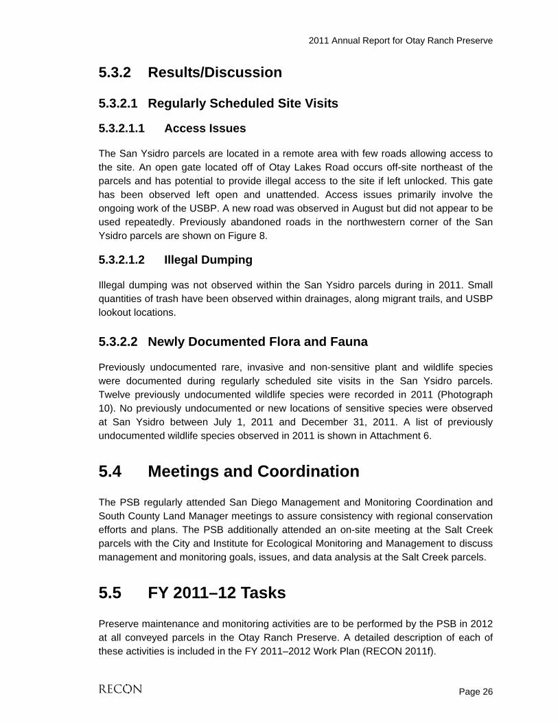
5.3.2 Results/Discussion
5.3.2.1 Regularly Scheduled Site Visits
5.3.2.1.1 Access Issues
The San Ysidro parcels are located in a remote area with few roads allowing access to the site. An open gate located off of Otay Lakes Road occurs off-site northeast of the parcels and has potential to provide illegal access to the site if left unlocked. This gate has been observed left open and unattended. Access issues primarily involve the ongoing work of the USBP. A new road was observed in August but did not appear to be used repeatedly. Previously abandoned roads in the northwestern corner of the San Ysidro parcels are shown on Figure 8.
5.3.2.1.2 Illegal Dumping
Illegal dumping was not observed within the San Ysidro parcels during in 2011. Small quantities of trash have been observed within drainages, along migrant trails, and USBP lookout locations.
5.3.2.2 Newly Documented Flora and Fauna
Previously undocumented rare, invasive and non-sensitive plant and wildlife species were documented during regularly scheduled site visits in the San Ysidro parcels. Twelve previously undocumented wildlife species were recorded in 2011 (Photograph 10). No previously undocumented or new locations of sensitive species were observed at San Ysidro between July 1, 2011 and December 31, 2011. A list of previously undocumented wildlife species observed in 2011 is shown in Attachment 6.
5.4 Meetings and Coordination
The PSB regularly attended San Diego Management and Monitoring Coordination and South County Land Manager meetings to assure consistency with regional conservation efforts and plans. The PSB additionally attended an on-site meeting at the Salt Creek parcels with the City and Institute for Ecological Monitoring and Management to discuss management and monitoring goals, issues, and data analysis at the Salt Creek parcels.
5.5 FY 2011–12 Tasks
Preserve maintenance and monitoring activities are to be performed by the PSB in 2012 at all conveyed parcels in the Otay Ranch Preserve. A detailed description of each of these activities is included in the FY 2011–2012 Work Plan (RECON 2011f).

FIGURE 8
Public Access Issues at San Ysidro Parcels
!.
6471400164713003
OT A Y L A K E
S R D
!.
6471400164713003
OT A Y L A K E
S R D
M:\JOBS3\5256\common_gis\fig8_annrpt_2012.mxd 1/5/2012
0 1,500Feet
Image Source: Copyright 2010 AerialsExpress (flown March 2010)
[Previously Conveyed Land (San Ysidro Parcels)
Previously Abandoned Road & Turn-around Locations
!. Open Gate
64713003 64714001
0 700Feet

M:\JOBS3\5256\bio\graphics\annrpt_2011\photos.indd 01/20/12
Giant Water Bug Eating a Treefrog, San Ysidro ParcelsPHOTOGRAPH 10

2011 Annual Report for Otay Ranch Preserve
Page 29
6.0 References Cited
American Ornithologists’ Union 1998 Check-list of North American Birds. 7th ed. Washington, D.C. Baker, R.J., L.C. Bradley, R.D. Bradley, J.W. Dragoo, M.D. Engstrom, R.S. Hoffmann, C.A. Jones, F. Reid, D.W. Rice, and C. Jones 2003 Revised Checklist of North American Mammals North of Mexico, 2003.
Occasional Papers of the Museum of Texas Tech University 229: 1-23. California Native Plant Society (CNPS) 2011 Inventory of Rare, Threatened, and Endangered Plants of California (online
edition, v.8-01a). Accessed January 5, 2012 from http://www.rareplants.cnps.org.
California, State of 2011a Natural Diversity Data Base. Special Vascular Plants, Bryophytes and Lichens
List (online edition), Department of Fish and Game. April. Accessed May, 2011 from http://www.dfg.ca.gov/ biogeodata/cnddb/plants_and_animals.asp.
2011b Natural Diversity Data Base. State and Federally Listed Endangered, Threatened, and Rare Plants of California. Department of Fish and Game.
2011c Natural Diversity Data Base. Special Animals List (online edition). Department of Fish and Game. January. Accessed May 2011 from http://www.dfg.ca.gov/ biogeodata/cnddb/ plants_and_animals.asp.
2011d Natural Diversity Data Base. State and Federally Listed Endangered & Threatened Animals of California. Department of Fish and Game.
Chula Vista, City of 2003 Multiple Species Conservation Plan Subarea Plan. February. Clark, Kevin B. 2011 Least Bell’s Vireo (Vireo bellii pusillus) Surveys and Nest Monitoring at the Salt
Creek Preserve, City of Chula Vista, San Diego County. September. Crother, Brian I. 2001 Scientific and Standard English Names of Amphibians and Reptiles of North
America North of Mexico, with Comments Regarding Confidence in our Understanding. Society for the Study of Amphibians and Reptiles Circular 29. iii + 82 pp.

2011 Annual Report for Otay Ranch Preserve
Page 30
2008 Scientific and Standard English Names of Amphibians and Reptiles of North America North of Mexico, with Comments Regarding Confidence in our Understanding. Sixth edition. Society for the Study of Amphibians and Reptiles.
Crother, Brian I. and 2003 Scientific and Standard English Names of Amphibians and Reptiles of North
America North of Mexico: Update. Herpetological Review. 34: 196-203. Elvin, Mark A. 2003 A New Species of Monardella (Lamiaceae) from Baja California, Mexico and
Southern California, United States. NOVON 13: 425-432. Accessed online in January 2012 from http://biostor.org
Hall, E. R. 1981 The Mammals of North America. 2nd ed. 2 vols. John Wiley & Sons, New York Jepson Flora Project (JFP) 2011 The Jepson Online Interchange for California Floristics. University of California
Berkeley. Regents of the University of California. Accessed online in May, 2011 from http://ucjepstest.berkeley.edu/interchange/.
Mattoni, R. 1990 Butterflies of Greater Los Angeles. The Center for the Conservation of
Biodiversity/Lepidoptera Research Foundation, Inc., Beverly Hills, CA. Opler, P. A., and A. B. Wright 1999 A Field Guide to Western Butterflies. Peterson Field Guide Series. Houghton
Mifflin, Boston. Otay Ranch POM Policy Committee 2009 Minutes from the meeting on May 29. Accessed online February 11 at
http://www.sdcounty.ca.gov/reusable_components/images/parks/doc/052909PC-MtgMinutes.
RECON 2011a January 1-March 31, 2011 Quarterly Report for Otay Ranch Preserve- Salt
Creek, San Ysidro, and Newly Conveyed Parcels. September. 2011b April 1-June 30, 2011 Quarterly Report for Otay Ranch Preserve FY 2010-11.
September. 2011c Draft 2011-12 Annual Work Plan for Otay Ranch Conveyed Lands Managed
by the Otay Ranch Preserve Owner/Manager. May.

2011 Annual Report for Otay Ranch Preserve
Page 31
2011d 2009-10 Annual Report for Otay Ranch Preserve-Salt Creek and San Ysidro Parcels. March.
2011e 2010-11 Annual Work Plan for Otay Ranch Conveyed Lands Managed by the Otay Ranch Preserve Owner/Manager. February.
2011f Draft 2011-12 Annual Work Plan for Otay Ranch Conveyed Lands Managed by the Otay Ranch Preserve Owner/Manager. December.
2012a 2010-11 Baseline Survey Report for the Dulzura Parcels of the Otay Ranch Preserve. January.
2012b 2010-11 Baseline Survey Report for the Jamul Mountains Parcels of the Otay Ranch Preserve. January.
2012c 2010-11 Baseline Survey Report for the Northern San Ysidro, McMillin, and Little Cedar Canyon Parcels of the Otay Ranch Preseve. January.
San Diego, County of 1993 Otay Ranch Phase 1 Resource Management Plan. 2007 Draft Otay Ranch Long-Term Implementation Program Public Review.
Accessed February 11 at http://www.sdcounty.ca.gov/dplu/docs/ LongTerm_IP_Cover_Letter_and_Document_12_31_07.pdf.
2002 Otay Ranch Phase 2 Resource Management Plan. Originally published June 1996. Revised August.
2010 Otay Ranch Preserve. Accessed online February 13 at http://www.sdcounty. ca.gov/parks/openspace/Otay_Ranch.html.
Unitt, P. A. 1984 Birds of San Diego County. Memoir No. 13. San Diego Society of Natural
History. 2004 San Diego County Bird Atlas. Proceedings of the San Diego Society of Natural
History, No. 39. San Diego Natural History Museum. U.S. Fish and Wildlife Service (USFWS) 2001 Least Bell’s Vireo Survey Guidelines.

ATTACHMENTS
ATTACHMENT 1

ATTACHMENT 1 TASKS PERFORMED:
JULY 1 THROUGH DECEMBER 31, 2011 AT OTAY RANCH PRESERVE
Date Personnel Notes
SITE VISITS
7/6/11 Dawna DeMars, Megan Lahti Salt Creek, San Ysidro 7/21/11 Anna Bennett, Megan Lahti Salt Creek, San Ysidro 8/1/11 Megan Lahti Salt Creek, San Ysidro 8/19/11 Megan Lahti, Harry Price Salt Creek, San Ysidro 8/24/11 Anna Bennett, Cailin O’Meara Salt Creek 10/28/11 J.R. Sundberg, Kayo Valenti Salt Creek 11/10/11 Anna Bennett, Cailin O’Meara Future conveyed parcels in Wolf Canyon,
Salt Creek 11/19/11 Anna Bennett, Megan Lahti Dulzura, Salt Creek 12/14/11 Cailin O’Meara, Megan Lahti Dulzura, Salt Creek
MEETINGS
7/14/11 Anna Bennett, Mark Dodero, Robert MacAller
Meeting with Glen Laube
7/27/11 Anna Bennett SDMMP meeting 8/24/11 Mark Dodero SDMMP meeting 11/2/11 Cailin O’Meara IEMM and SDMMP Goals and Objectives
Workshop 12/15/11 Anna Bennett, Mark Dodero On-site meeting with IEMM, Glen Laube, and
Marisa Lundstedt 12/14/11 Cailin O’Meara SDMMP meeting
REPORTS
8/9/11 Anna Bennett, Mark Dodero, Megan Lahti
4th draft quarterly report submittal
8/31/11 Anna Bennett, Mark Dodero, Cailin O’Meara
Revised Draft FY 11-12 Work Plan submittal
11/9/11 Anna Bennett, Mark Dodero, Cailin O’Meara
Revised Draft FY 11-12 Work Plan submittal
12/14/11 Anna Bennett, Mark Dodero, Cailin O’Meara
Revised Draft FY 11-12 Work Plan submittal
12/30/11 Anna Bennett, Kevin Clark, Mark Dodero
LBV report submittal
LEAST BELL’S VIREO SURVEYS & NEST MONITORING
7/11/11 Kevin Clark Nest monitoring at Salt Creek 7/18/11 Kevin Clark LBV survey at Salt Creek
ACCESS CONTROL
7/21/11 Anna Bennett, Megan Lahti Fence installation 8/18/11 Anna Bennett, Megan Lahti Fence repair

ATTACHMENT 2

ATTACHMENT 2 PREVIOUSLY UNDOCUMENTED PLANT SPECIES OBSERVED IN SALT CREEK PARCELS
Scientific name Common Name Origin
ASTERACEAE SUNFLOWER FAMILY Symphyotrichum subulatum (Michx.) G. L. Nesom
var. parviflorum (Nees) S. D. Sundb. annual saltmarsh aster N
BRASSICACEAE (CRUCIFERAE) MUSTARD FAMILY
Lepidium latifolium L. perennial pepperweed I
ELATINACEAE WATERWORT FAMILY Elatine brachysperma A. Gray short-seed waterwort N
MARSILEACEAE MARSILEA FAMILY Marsilea vestita Hook. & Grev. hairy waterclover N Pilularia americana A. Braun American pillwort N
PLANTAGINACEAE PLANTAIN FAMILY Callitriche sp. water-starwort N Plantago erecta E. Morris dot-seed plantain N Veronica peregrina L. ssp. xalapensis (Kunth)
Pennell purslane speedwell N
POACEAE (GRAMINEAE) GRASS FAMILY Schismus sp. Mediterranean grass
TYPHACEAE CATTAIL FAMILY
Typha sp. cattail N
VERBENACEAE VERVAIN FAMILY
Phyla nodiflora (L.) Greene garden lippia N ORIGIN N = Native to locality I = Introduced species from outside locality

ATTACHMENT 3

ATTACHMENT 3 PREVIOUSLY UNDOCUMENTED WILDLIFE SPECIES OBSERVED IN SALT CREEK
PARCELS
Scientific Name Common Name
INVERTEBRATES (Nomenclature from Eriksen and Belk 1999; Milne and Milne 1980; Mattoni 1990;
and Opler and Wright 1999)
LYCAENIDAE BLUES, COPPERS, & HAIRSTREAKS Icaricia acmon acmon acmon blue PIERIDAE WHITES & SULPHURS Pontia protodice common or checkered white Zerene sp. dogface
REPTILES (Nomenclature from Crother 2001 and Crother et al. 2003)
IGUANIDAE IGUANID LIZARDS Sceloporus occidentalis western fence lizard
BIRDS (Nomenclature from American Ornithologists’ Union 1998 and Unitt 2004)
ACCIPITRIDAE HAWKS, KITES, & EAGLES Elanus leucurus white-tailed kite ARDEIDAE HERONS & BITTERNS Ardea herodias great blue heron Butorides virescens green heron CATHARTIDAE NEW WORLD VULTURES Cathartes aura turkey vulture PARULIDAE WOOD WARBLERS Vermivora celata orange-crowned warbler PTILOGONATIDAE SILKY FLYCATCHERS Phainopepla nitens lepida phainopepla RALLIDAE RAILS, GALLINULES, & COOTS Rallus limicola limicola Virginia rail TIMALIIDAE BABBLERS Chamaea fasciata henshawi wrentit TROGLODYTIDAE WRENS Cistothorus palustris marsh wren TYRANNIDAE TYRANT FLYCATCHERS Sayornis saya Say’s phoebe
MAMMALS (Nomenclature from Baker et al. 2003)
LEPORIDAE RABBITS & HARES Sylvilagus sp. cottontail

ATTACHMENT 4

ATTACHMENT 4 PREVIOUSLY UNDOCUMENTED SENSITIVE PLANT SPECIES OBSERVED IN
SALT CREEK PARCELS
Species
State/ Federal Status
CNPSList
City of Chula Vista
Habitat/Blooming Period
POLEMONIACEAE PHLOX FAMILY
Navarretia fossalis spreading navarretia
–/FT 1B MSCP Annual herb; vernal pools, marshes and swamps, chenopod scrub; blooms April–June; elevation 100–4,300 feet.
FEDERAL CANDIDATES AND LISTED PLANTS STATE LISTED PLANTS FE = Federally listed endangered CE = State listed endangered FT = Federally listed threatened CR = State listed rare FC = Federal candidate for listing as endangered or threatened CT = State listed threatened CALIFORNIA NATIVE PLANT SOCIETY LISTS 1A = Species presumed extinct. 1B = Species rare, threatened, or endangered in California and elsewhere. These species are eligible
for state listing. 2 = Species rare, threatened, or endangered in California but more common elsewhere. These species
are eligible for state listing. 3 = Species for which more information is needed. Distribution, endangerment, and/or taxonomic
information is needed. 4 = A watch list of species of limited distribution. These species need to be monitored for changes in
the status of their populations. CITY OF CHULA VISTA NE = Narrow endemic MSCP = Multiple Species Conservation Program covered species

ATTACHMENT 5

ATTACHMENT 5 PREVIOUSLY UNDOCUMENTED SENSITIVE WILDLIFE SPECIES OBSERVED IN
SALT CREEK PARCELS
Species Status Habitat
ACCIPITRIDAE HAWKS, KITES, & EAGLES
Cooper’s hawk (nesting) Accipiter cooperii
CSC, MSCP Mature forest, open woodlands, wood edges, river groves. Parks and residential areas. Migrant and winter visitor.
CSC = California Department of Fish and Game species of special concern MSCP = City of Chula Vista Multiple Species Conservation Program covered species

ATTACHMENT 6

ATTACHMENT 6
PREVIOUSLY UNDOCUMENTED WILDLIFE SPECIES OBSERVED AT SAN YSIDRO PARCELS
Scientific Name
Common Name
INVERTEBRATES
LYCAENIDAE BLUES, COPPERS, & HAIRSTREAKS Pieris rapae cabbage white
BELOSTOMATIDAE GIANT WATER BUGS Unknown species Giant water bug
NYMPHALIDAE BRUSH-FOOTED BUTTERFLIES Junonia coenia common buckeye
AMPHIBIANS
HYLIDAE TREE FROGS Pseudacris cadaverina California treefrog
REPTILES
COLUBRIDAE COLUBRID SNAKES
Thamnophis elegans western terrestrial gartersnake
IGUANIDAE IGUANID LIZARDS Sceloporus occidentalis western fence lizard
BIRDS
ACCIPITRIDAE HAWKS, KITES, & EAGLES Buteo jamaicensis red-tailed hawk
CHARADRIIDAE LAPWINGS & PLOVERS Charadrius vociferus vociferus killdeer
TYTONIDAE BARN OWLS Geococcyx californianus greater roadrunner
TYRANNIDAE TYRANT FLYCATCHERS Tyrannus verticalis Western kingbird
ICTERIDAE BLACKBIRDS & NEW WORLD ORIOLES Agelaius phoeniceus red-winged blackbird
MAMMALS
LEPORIDAE RABBITS & HARES Sylvilagus bachmani brush rabbit Sylvilagus audubonii desert cottontail
(I) = Introduced species

ATTACHMENT 7

ATTACHMENT 7 PREVIOUSLY UNDOCUMENTED SENSITIVE PLANT SPECIES OBSERVED AT SAN YSIDRO
PARCELS
Species
State/ Federal Status
CNPSList
City of Chula Vista
Habitat/Blooming Period
LAMIACEAE MINT FAMILY
Monardella stoneana Jennifer’s monardella
-/- 1B.2 - Perennial herb; rocky intermittent streambeds, closed-cone coniferous forest, chaparral, coastal scrub, riparian scrub; blooms June-September.
FEDERAL CANDIDATES AND LISTED PLANTS STATE LISTED PLANTS FE = Federally listed endangered CE = State listed endangered FT = Federally listed threatened CR = State listed rare FC = Federal candidate for listing as endangered or threatened CT = State listed threatened CALIFORNIA NATIVE PLANT SOCIETY LISTS 1A = Species presumed extinct. 1B = Species rare, threatened, or endangered in California and elsewhere. These species are eligible
for state listing. 2 = Species rare, threatened, or endangered in California but more common elsewhere. These species
are eligible for state listing. 3 = Species for which more information is needed. Distribution, endangerment, and/or taxonomic
information is needed. 4 = A watch list of species of limited distribution. These species need to be monitored for changes in
the status of their populations. CITY OF CHULA VISTA NE = Narrow endemic MSCP = Multiple Species Conservation Program covered species