2012 03 the tidal regime of the severn estuary paul evans, cardiff university
TRANSCRIPT

The Tidal Regime of the Severn Estuary: The Practicalities of Monitoring Tidal Flow
Paul Evans, Research Assistant & PhD Researcher – LCRI MarineSchool of Earth and Ocean Sciences, Cardiff University

Overview
• Tidal Regime of the Severn Estuary
• Tidal Energy in Wales
• Case Study 1: Tidal flow Monitoring in the Irish Sea
• Case Study 2: Tidal flow Monitoring in the Severn Estuary
• Further Work

Severn Estuary Tidal Regime
• Partially enclosed body of tidal waters – 250km
• Hypertidal (MTR>6m); ca. 7m mouth of Channel, ca. 12m upper reaches
• Semi-Diurnal
Uncles (2010)

Severn Estuary Tidal Regime
• Fast tidal currents = Strong vertical and horizontal mixing, and large bed stresses = Horizontal dispersion, near vertical homogeneity in salinity, temperature and phytoplankton
• Max. mean spring and neap tide in the vicinity of Flat Holm = 3.0 ms-1 and 1.0ms-1
Uncles (2010) Uncles (2010)

Severn Estuary Tidal Regime
• Hydrostatic head at the mouth and the landward extent of the estuary during flood and ebb conditions create a tidal flow – peaks lag behind the high and low tides by ca. 3 hours
• Newport Deep (NE flood)
• Bristol Deep – SW ebb –greater tidal flow (narrow and sinuous) Cotter (1975)
Flat HolmSteep
Holm
Bristol
Deep
The
Wolves

Tidal Range vs. Tidal Stream
• Tidal range – impounding high tide level water behind a barrage or in a lagoon can create a head above the lower tidal water outside, which can be run through turbines when releasing the impounded water. This technology is likened to damming a reservoir once or twice daily.
• Tidal stream involves extracting kinetic energy directly by use of turbines from the horizontal tidal current generated by the movement of the tidal bulge as the earth rotates.

Tidal Range Technologies
Xia et al. (2010)
Natural Condition
Xia et al. (2010)
Cardiff to Weston Barrage
• Cardiff to Weston Barrage –
Installed capacity = 8640 MW; Annual
electricity supply = 17 TWh;
Generation of 5% of UK’s electricity
Xia et al. (2010)
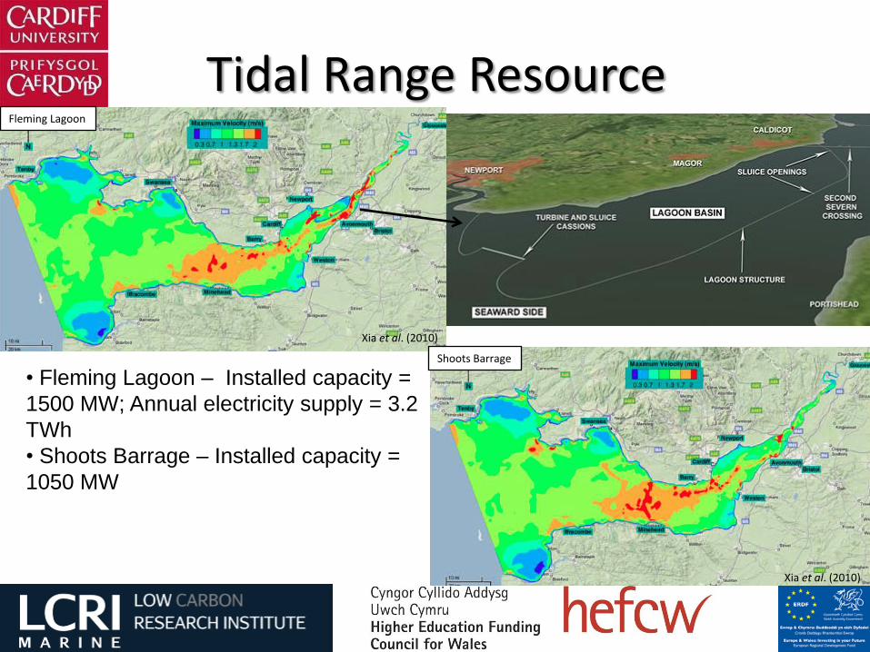
Tidal Range Resource
Xia et al. (2010)
Fleming Lagoon
Xia et al. (2010)
Shoots Barrage
• Fleming Lagoon – Installed capacity =
1500 MW; Annual electricity supply = 3.2
TWh
• Shoots Barrage – Installed capacity =
1050 MW

Tidal Stream Resource
Ebb tide – HW+3 (Milford Haven)Flood tide – HW-3 (Milford Haven)

Welsh Tidal Stream Resource
Potential Areas:
– Anglesey
– Pembrokeshire
– Bristol Channel
Source: Renewables Energy Atlas

Marine Renewable Energy in Wales
Welsh Government Policy:– 40GW marine renewable energy
potential
– Capture 10% of wave and tidal stream energy off the Welsh Coastline by 2025 (equates to 4GW potential)
LCRI Marine:– Cutting edge research to support industrial development
– Tidal resource assessment

Marine Current Turbines – ‘SeaGen’
• Skerries Tidal Stream Array
• 9 SeaGen devices array with a total capacity of up to 10MW
Tidal Energy Limited – ‘DeltaStream’• Demonstration project in Ramsey Sound, Pembrokeshire – capacity to provide electricity for up to 1000 homes
• LCRI Marine survey data used to inform site selection
Tidal Stream Devices in Wales
http://www.tidalenergyltd.com/?page_id=640

13
Case Study 1: Irish Sea

14
The Bishops and Clerks – a historical hazard to navigation
“The Bishop and these his clerkes preache deadly doctrine to their winter audience" George Owen, 1552-1613.
.
RNLI Lifeboat Joseph Soar – south end of Ramsey IslandRNLI Lifeboat Swn-Y-Mor alongside World Concord, 27th
November 1954
Case Study 1: Irish Sea

• Rock Outcrops
• Small Islands
• Underwater pinnacles
• Deep channel
• Large island
http://www.ramseyisland.co.uk/ramsey-and-the-outer-islands/ramsey-island/
Case Study 1: Irish Sea

The Bitches
Horse RockWhitesand Bay
Case Study 1: Irish Sea
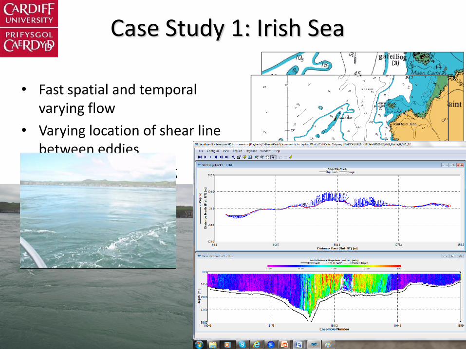
• Fast spatial and temporal varying flow
• Varying location of shear line between eddies
• Up- and down-welling
Case Study 1: Irish Sea

Case Study 1: Irish Sea

Case Study 1: Irish Sea

Slack
Slack+1
Slack+2
Slack+3
Slack+4
Slack+5
Case Study 1: Irish Sea

HWHW+0.5
Case Study 1: Irish Sea

Case Study 2: Severn Estuary
Survey Area
Flat Holm Island
The Wolves

Case Study 2: Severn Estuary

Case Study 2: Severn Estuary

Case Study 2: Severn Estuary

Further Work
• Analysis and interpretation of flow data
• Laboratory experiments – wake studies downstream of cone
• Numerical model validation
• Further surveys in vicinity of Flat Holm
• http://www.lcrimarine.org.uk/

Thank Youfor
Listening
27