2012 delhi sands flower-loving fly survey report
TRANSCRIPT
Western Riverside County
Multiple Species Habitat Conservation Plan
Biological Monitoring Program
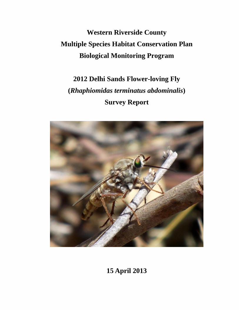
2012 Delhi Sands Flower-loving Fly
(Rhaphiomidas terminatus abdominalis)
Survey Report
15 April 2013
2012 Delhi Sands Flower-loving Fly Survey Report
TABLE OF CONTENTS INTRODUCTION ................................................................................................................................................1
SURVEY GOALS AND OBJECTIVES.................................................................................................2
METHODS.........................................................................................................................................................2
PROTOCOL DEVELOPMENT............................................................................................................2 PERSONNEL AND TRAINING...........................................................................................................3 STUDY SITE SELECTION ................................................................................................................3 SURVEY METHODS........................................................................................................................5 DATA ANALYSIS ...........................................................................................................................5
RESULTS ..........................................................................................................................................................5
DISCUSSION .....................................................................................................................................................6
RECOMMENDATIONS.....................................................................................................................7
REFERENCES ....................................................................................................................................................8
LIST OF TABLES AND FIGURES Figure 1. Delhi Sands flower-loving fly detections at Teledyne in 2012 .......................................................4
LIST OF APPENDICES
Appendix. Western Riverside County MSHCP Biological Monitoring Program Protocol for Delhis Sands Flower-loving Fly Surveys, June 2012............................................................................................................9
Western Riverside County MSHCP Biological Monitoring Program
ii
2012 Delhi Sands Flower-loving Fly Survey Report
NOTE TO READER:
This report is an account of survey activities conducted by the Biological Monitoring Program for the Western Riverside County Multiple Species Habitat Conservation Plan (MSHCP). The MSHCP was permitted in June 2004. The Monitoring Program monitors the distribution and status of the 146 Covered Species within the Conservation Area to provide information to Permittees, land managers, the public, and the Wildlife Agencies (i.e., the California Department of Fish and Game and the U.S. Fish and Wildlife Service). Monitoring Program activities are guided by the MSHCP species objectives for each Covered Species, the information needs identified in MSHCP Section 5.3 or elsewhere in the document, and the information needs of the Permittees.
MSHCP reserve assembly is ongoing and it is expected to take 20 or more years to assemble the final Conservation Area. The Conservation Area includes lands acquired for conservation under the terms of the MSHCP and other lands that have conservation value in the Plan Area (called public or quasi-public lands in the MSHCP). In this report, the term “Conservation Area” refers to the Conservation Area as understood by the Monitoring Program at the time the surveys were planned and conducted.
We would like to thank and acknowledge the land managers in the MSHCP Plan Area, who in the interest of conservation and stewardship facilitate Monitoring Program activities on the lands for which they are responsible. A list of the lands where data collection activities were conducted in 2012 is included in Section 7.0 of the Western Riverside County Regional Conservation Authority (RCA) Annual Report to the Wildlife Agencies. Partnering organizations and individuals contributing data to our projects are acknowledged in the text of appropriate reports.
While we have made every effort to accurately represent our data and results, it should be recognized that data management and analysis are ongoing activities. Any reader wishing to make further use of the information or data provided in this report should contact the Monitoring Program to ensure that they have access to the best available or most current data.
The primary preparer of this report was Monitoring Program Administrator, Adam Malisch. If there are any questions about the information provided in this report, please contact the Monitoring Program Administrator. If you have questions about the MSHCP, please contact the Executive Director of the RCA. Further information on the MSHCP and the RCA can be found at www.wrc-rca.org.
Contact Information:
Executive Director Western Riverside County MSHCP Western Riverside County Monitoring Program Administrator Regional Conservation Authority c/o Adam Malisch Riverside Centre Building 4500 Glenwood Drive, Bldg. C 3403 10th Street, Suite 320 Riverside, CA 92501 Riverside, CA 92501 Ph: (951) 248-2552 Ph: (951) 955-9700
Western Riverside County MSHCP Biological Monitoring Program
iii
2012 Delhi Sands Flower-loving Fly Survey Report
INTRODUCTION The Delhi Sands flower-loving fly (Rhaphiomidas terminatus abdominalis; Delhi
fly) is federally listed as endangered, and is narrowly distributed in portions of Riverside and San Bernardino Counties in areas with Delhi series soils. The species is known to have occurred within three Core Areas defined by the Western Riverside County Multiple Species Habitat Conservation Plan (MSHCP): Jurupa Hills, Agua Mansa Industrial Center, and Mira Loma (Dudek & Associates 2003). To date, conservation of the species within the MSHCP Plan Area has only occurred at the Teledyne site within the Jurupa Hills Core Area. There are no lands that are currently part of the Conservation Area within the other two Core Areas for this species.
Delhi fly conservation objective 2 states that successful reproduction shall be documented at all Core Areas once a year for the first five years after permit issuance and then as appropriate, but not less frequently than every eight years thereafter (Dudek & Associates 2003). Reproductive success is defined in the MSHCP as the presence of pupal cases (exuviae) or newly-emerged (teneral) individuals. We describe here the procedure and results of the MSHCP Biological Monitoring Program’s 2012 effort to monitor Delhi fly in the Jurupa Hills.
Delhi Sands flower-loving fly has distinctive biological and habitat requirements and faces a number of threats (U.S. Fish and Wildlife Service [USFWS] 1997). The life cycle of the fly includes egg, larval, pupal, and adult stages. Only the adult stage occurs above-ground, when adults emerge to breed during the summer months. The species is restricted to fine, sandy Delhi series soils, usually with wholly- or partly-stabilized sand dunes and sparse native vegetation. Areas with suitable fly habitat have been highly affected by anthropogenic activities, including conversion to agriculture, residential and commercial development, surface mining for sand, dumping of trash and cow manure, and damage by off-road vehicles. Invasive exotic plants are also thought to degrade fly habitat by increasing vegetation cover or by altering soil conditions through dune stabilization and changes in soil moisture.
We began annual surveys for Delhi fly at the Teledyne site in 2005. The primary goal of our surveys has been to evaluate if the fly was successfully reproducing; secondary goals have been to estimate adult detection probability and density and to gather data on habitat associations. Detectability is important because the federal Recovery Plan for the species requires information on population density and trends (USFWS 1997), which typically require associated detection probability estimates. Total fly detections were relatively low from 2005 through 2007 and therefore did not allow us to model detection probability. We detected greater numbers of Delhi fly in 2008, 2009, and 2010, allowing us to calculate reliable estimates of detection probability and density in those years (see relevant years survey reports for details, available at http://www.wrc-rca.org/library.asp#id187).
Continuing to model detection probability along with abundance is important, as it will allow us to determine whether annual changes in the number of detections are due to changes in fly abundance or changes in detectability. However, these metrics are not technically required in order to satisfy the species-specific monitoring objective, as
Western Riverside County MSHCP Biological Monitoring Program
1
2012 Delhi Sands Flower-loving Fly Survey Report
described above. Because gathering the data to calculate detection probabilities and annual abundance estimates requires significant resources and because the Delhi fly population at Teledyne appears to be stable or increasing (Biological Monitoring Program 2010), we postponed this more intensive study design in favor of a less time-consuming survey aimed directly at meeting the species-specific objective described above.
Our focus for the 2011 field season was to efficiently meet the species-specific monitoring objective while reducing the personnel requirements demanded by previous study designs. The 2011 survey protocol consisted of untimed area searches within appropriate habitat at conserved sites known to be recently occupied. The survey objectives were achieved with greatly reduced survey effort compared to recent years. We reduced the person-hours expended in 2011, as compared to those expended in 2010, by approximately 66%. This survey strategy was continued in 2012. We also wanted to record annual images from three photo stations to qualitatively track vegetation conditions and continue working closely with MSHCP Management Program staff on their habitat management efforts at Teledyne.
Survey Goals and Objectives 1) Document successful reproduction by Delhi Sands flower-loving fly at the
Teleydne site in the Jurupa Hills Core Area. a. Record observations of teneral individuals and/or exuviae.
2) Monitor the spread of short-pod mustard (Hirschfeldia incana) and non-native grasses (Poaceae) across the dune system at the Teledyne site.
a. Record digital images annually from three photo stations to document changes in vegetation structure and composition.
3) Collaborate with the Management Program to implement an appropriate habitat management strategy for the Teledyne site.
METHODS Protocol Development
We derived our field methods from the survey guidelines proposed by USFWS (1996), which were developed to determine presence/absence of Delhi fly by slowly traversing appropriate habitat. We augmented that protocol in 2005 by establishing line transects and measuring the perpendicular distance between the transect centerline and individual fly observations, with the goal of estimating population density and detection probability following distance sampling methodology (Buckland et al. 2001). We continued to use this basic protocol, with minor adjustments, to survey for Delhi fly from 2006 through 2010. This survey method was thorough and systematic, covering the entire six hectares (ha) at Teledyne, but time-consuming: in 2010 we spent approximately 268 person-hours conducting 67 site surveys across 39 days, approximately 4 h per survey.
We also established three permanent photo-monitoring stations in 2006 to qualitatively monitor the spread of H. incana and non-native grasses (Poaceae) across the
Western Riverside County MSHCP Biological Monitoring Program
2
2012 Delhi Sands Flower-loving Fly Survey Report
dune system. These species may pose a threat to fly habitat through dune stabilization (USFWS 1997).
In 2011, we scaled back the survey effort to substantially reduce the personnel resources needed while still gathering the required data to meet the given species-specific monitoring objective described above. The 2011 and 2012 survey protocol replaced the transect lines with untimed area searches of appropriate habitat at conserved sites known to recently support adult individuals (Appendix).
In previous years we collected vegetation status information at the Teledyne site using various vegetation sampling methods (e.g., randomly-distributed 2.25-m2 vegetation quadrats in 2010 [Biological Monitoring Program 2011]). However, because vegetation surveys in the past several years require significant staff time and have been inconclusive in quantitatively determining habitat variables that are important to fly presence/absence, no vegetation sampling has been conducted since 2010.
Personnel and Training All field observers studied a species-specific training manual prepared by
Biological Monitoring Program leads, relevant invertebrate field guides, and preserved specimens of co-occurring winged invertebrate species. We emphasized, through the training materials, the ability to recognize morphological and behavioral field traits of Delhi fly, and proficiency in identifying all co-occurring winged insects to family. We also trained observers to differentiate between adult and teneral individuals, and to identify plant species common at the Teledyne site. All observers participated in field-based training that involved observing, capturing, and identifying co-occurring insects, excluding Delhi fly. Field observers also passed the USFWS practical exam and observed adult Delhi fly in the field before participating in surveys.
The Western Riverside County Regional Conservation Authority funded Delhi fly surveys in 2012. The following Biological Monitoring Program staff conducted these surveys:
• Karyn Drennen • Masanori Abe • Ashley Ragsdale • Lynn Miller • Ana Hernandez
Study Site Selection The Teledyne site is located in the Jurupa Hills along the Riverside-San
Bernardino County border in the vicinity of Pyrite Street (Fig. 1). The site encompasses just over six ha of Delhi series soils and is dominated by coastal sage scrub vegetation (Dudek & Associates 2003). Common plants found at the site include Eriogonum fasciculatum, Ambrosia acanthicarpa, Amsinckia menziesii, Rhus trilobata, Brassica spp., Croton californicus, and various non-native grasses.
Western Riverside County MSHCP Biological Monitoring Program
3
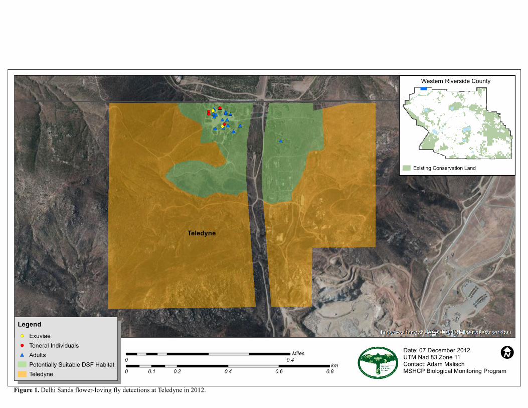
Figure 1. Delhi Sands flower-loving fly detections at Teledyne in 2012.
Date: 07 December 2012UTM Nad 83 Zone 11Contact: Adam MalischMSHCP Biological Monitoring Program
I 0 0.4Miles
0 0.2 0.4 0.6 0.80.1km
Western Riverside County
Legend!( Exuviae!( Teneral Individuals#* Adults
Potentially Suitable DSF HabitatTeledyne
Existing Conservation Land
Teledyne
I
2012 Delhi Sands Flower-loving Fly Survey Report
Survey Methods Survey methods generally followed those described in the USFWS interim survey
guidelines (USFWS 1996). Surveyors searched the survey site by meandering within potentially suitable habitat at a slow pace and scanning for adult Delhi fly in the air or perched on vegetation. Surveys were conducted between 1000 h and 1400 h during clear skies and low winds (<5 mph). When we observed an adult, we recorded UTM location coordinates, time, sex, activity, and age class (adult/teneral) of the detected fly. If possible, we took photos of teneral individuals or unusual behaviors. Surveyors took care to avoid disturbing any individuals that were detected. The methods we used in 2012 are described more completely in the attached protocol (Appendix).
We revisited established photo stations for the seventh time since 2006, and recorded digital images in the four cardinal directions. Results from previous years suggest that Delhi fly were most abundant in areas that contain a high percentage of native vegetation and more than 60% open-sand substrate (USFWS 1997; Biological Monitoring Program 2007).
Beyond a strong affinity for Delhi series soils, within-site habitat associations have been difficult to determine, due either to few detections or to relatively poor correlations between fly presence and measured habitat features. Because previous efforts to establish useful quantitative correlations between DSF presence and habitat attributes have been both time-consuming and largely inconclusive, this effort was suspended in 2011. Future vegetation monitoring efforts will be initiated if a particular hypothesis requires testing, or pending direction from Reserve Managers, Permittees, or the Wildlife Agencies.
Data Analysis The 2012 surveys were designed to opportunistically determine presence of adult Delhi fly at a given site. Because of the loosely defined survey area and lack of distance sampling data comparable to previous years’ efforts, the data are not suitable for typical data analysis. Thus, none was conducted.
RESULTS We began surveys on 12 July and ended surveys on 17 August 2012. We
conducted 15 surveys at the Teledyne site. Surveys lasted approximately three hours, and were conducted by a single observer. Accounting for travel time to and from Teledyne (0.5 hours each way), the total survey effort expended at Teledyne in 2011 was approximately 60 person-hours.
We observed Delhi fly during 10 surveys, documenting a total of 21 individual observations (14 males, 5 females, 2 unknown). Four of these individuals were teneral. We also recorded two exuviae, thus confirming reproduction at the Teledyne site in 2012 (Fig. 1). Observations were concentrated around the open dune area in the northwestern portion of the survey area. Although surveyors did explore the full extent of the area occupied by Delhi fly during previous years’ survey efforts, they focused on the open dune area to maximize efficiency of time spent surveying. Thus, the displayed
Western Riverside County MSHCP Biological Monitoring Program
5

2012 Delhi Sands Flower-loving Fly Survey Report
distribution of observations should not be taken to represent the true distribution of adult Delhi fly at Teledyne in 2012.
The first Delhi fly was observed on 12 July and the last on 16 August. Because the first individual was observed on the first survey day of the season, and there was just one negative survey after 16 August, this period should not be considered an accurate representation of the 2012 flight season span. In fact, the only individual observed on 16 August was teneral, indicating that individuals were continuing to emerge. However, with survey goals achieved, further efforts were suspended for the year.
We recorded digital images in the four cardinal directions at each of three previously established photo stations. These images are stored with those from previous years and will be used to qualitatively track vegetation changes through time and to visually complement quantitative changes in vegetation through time if additional sampling is conducted in the future.
DISCUSSION In 2012, the eighth consecutive year of monitoring the Delhi Sands flower-loving
fly, our focus was to efficiently meet the species-specific monitoring objective while continuing the reduced-effort study design employed in 2011. Our secondary objective was to continue working closely with the MSHCP Management Program regarding habitat management at Teledyne.
We confirmed fly reproduction again at Teledyne in 2012, documenting four teneral individuals and two exuviae, with greatly reduced survey effort compared to recent years (2005 – 2010). We reduced the person-hours expended again (~268 in 2010, ~88 in 2011, ~60 in 2012) although per-survey effort remained constant at ~4 h. Because we did not conduct enough surveys to gather the sample size needed to estimate density, we can not comment on the status of the fly population at Teledyne in 2012 other than to confirm that reproduction occurred on site, and that the species was readily available for detection during surveys.
The MSHCP Management Program conducts habitat management activities at Teledyne to improve site conditions for Delhi fly in accordance with the habitat management plan (Marchant 2005). Previous years’ management actions have included fencing portions of the site commonly accessed by off-highway vehicles and erosion control, strategies that seem to have reduced the impact of both disturbances. Monitoring Program staff and Management Program staff met onsite early in 2012 to identify appropriate management actions. We agreed that measures to reduce the percent cover of vegetation were a priority and that the effort should focus particularly, but not exclusively, on non-native vegetation. In the fall of 2012, Management Program staff trimmed and cut vegetation, with hand tools, in areas designated by the habitat management plan (Marchant 2005). All management actions are conducted well after the adult flight season concludes. Future management will be conducted as needed depending on year-to-year site conditions and monitoring results.
Western Riverside County MSHCP Biological Monitoring Program
6

2012 Delhi Sands Flower-loving Fly Survey Report
Recommendations The species-specific objective for Delhi Sands flower-loving fly states that
successful reproduction shall be documented at all Core Areas once a year for the first five years after permit issuance and then as appropriate, but not less frequently than every eight years thereafter. The MSHCP permit was issued in 2004; therefore further surveys conducted to document successful annual reproduction of Delhi fly are not strictly mandated. However, given the endangered status of the species, and the minimal effort required to document successful reproduction at the sole occupied site within the Plan Area, we should continue to monitor the Delhi fly annually so long as personnel are available.
Modeling detection probability along with density is important, as it allows us to regularly estimate the density of individuals and determine whether changes in the number of detections are due to changes in fly abundance or changes in detectability. We plan to periodically conduct the more demanding line transect study design that allows us to model detection probability and density in order to better describe population changes at occupied sites, especially as active habitat management continues. Unless otherwise directed, or precluded by staff availability, we should estimate density at occupied sites at least once every eight years, but ideally every 3-5 years. We will also evaluate the habitat at newly acquired sites that may be suitable for Delhi fly as they are added to the Conservation Area. If suitable habitat is present we should survey these additional sites with the same regularity as Teledyne.
There is an on-going need to better determine specific vegetation and soil requirements for Delhi fly. Monitoring Program reports in previous years have tentatively identified A. menziesii, H. incana, and stabilized sand as negatively associated with presence of fly, while bare ground and loose sand have been tentatively identified as positively associated, although results have been inconsistent across years and require substantial additional field effort. Perhaps above-ground vegetation and habitat conditions are not as important for adults as subsurface habitat components (i.e., root structure, soil conditions, food sources) are for larvae. The overwintering larval stage is by far the longest in the fly’s life cycle (USFWS 1997) but investigating subsurface habitat conditions is likely beyond the feasible scope of Monitoring Program activities as it is not essential in order to meet the listed monitoring objective and involves additional disturbance of habitat for this endangered species. Furthermore, the mobility of the adult fly makes it difficult to properly place vegetation sampling plots. Our approach has been to center plots over areas where an individual was observed perching. Many times, however, a fly perches for only a few seconds before taking flight again. It is therefore unclear whether perched sites are better indicators of habitat preference than other areas over which Delhi fly are observed in flight.
While the number of fly observations varies across the site, there are no large areas within the polygon of mapped Delhi series soils at Teledyne where they are not observed. Therefore, as suggested in previous reports, we may need to expand vegetation survey efforts beyond the borders of the survey area to gather data from areas in which Delhi fly do not occur. One strategy would be to sample small quadrats both within and outside of the survey area, but within the Teledyne site. Another alternative would be to
Western Riverside County MSHCP Biological Monitoring Program
7
2012 Delhi Sands Flower-loving Fly Survey Report
identify an area with few fly observations (within or adjacent to the survey area) in which the vegetation could be manipulated experimentally. For example, A. menziesii could be removed from treatment plots. These plots could then be monitored for Delhi fly and compared to control areas. Given the federally endangered listing status of the species and the small size of the Teledyne site, careful planning would be required to avoid inadvertently damaging habitat or individuals.
In addition to any vegetation sampling conducted in the future we will continue to record digital images at established photo stations to qualitatively document the status of invasive plants and changes in community structure at Teledyne.
REFERENCES Biological Monitoring Program. 2007. Western Riverside County MSHCP Biological
Monitoring Program Delhi Sands Flower-loving Fly (Rhaphiomidas terminatus abdominalis) Survey Report, 2006. Report prepared for the Western Riverside County Multiple Species Habitat Conservation Plan. Riverside, CA. Available from: http://www.wrc-rca.org/library.asp.
Biological Monitoring Program. 2010. Western Riverside County MSHCP Biological Monitoring Program Delhi Sands Flower-loving Fly (Rhaphiomidas terminatus abdominalis) Survey Report, 2009. Report prepared for the Western Riverside County Multiple Species Habitat Conservation Plan. Riverside, CA. Available from: http://www.wrc-rca.org/library.asp.
Biological Monitoring Program. 2011. Western Riverside County MSHCP Biological Monitoring Program Delhi Sands Flower-loving Fly (Rhaphiomidas terminatus abdominalis) Survey Report, 2010. Report prepared for the Western Riverside County Multiple Species Habitat Conservation Plan. Riverside, CA. Available from: http://www.wrc-rca.org/library.asp.
Buckland ST, Anderson DR, Burnham KP, Laake JL, Borchers DL, Thomas L. 2001. Introduction to distance sampling. Oxford (UK): Oxford University Press.
Dudek & Associates. 2003. Western Riverside County Multiple Species Habitat Conservation Plan (MSHCP). Final MSHCP, Volumes I and II. Prepared for County of Riverside Transportation and Lands Management Agency. Prepared by Dudek & Associates, Inc. Approved June 17, 2003.
Marchant TA. 2005. Delhi Sands Flower-loving Fly Habitat Management Plan, Jurupa Hills, Riverside County. Prepared by Ecosystem Restoration Associates for County of Riverside Transportation and Land Management Agency.
[USFWS] U.S. Fish and Wildlife Service. 1996. Interim General Survey Guidelines for the Delhi Sands Flower-loving Fly. U.S. Fish and Wildlife Service, Carlsbad, CA.
[USFWS] U.S. Fish and Wildlife Service. 1997. Delhi Sands flower-loving fly (Rhaphiomidas terminatus abdominalis) Recovery Plan. U.S. Fish and Wildlife Service, Portland, OR.
Western Riverside County MSHCP Biological Monitoring Program
8

2012 Delhi Sands Flower-loving Fly Survey Report
Appendix. Western Riverside County MSHCP Biological Monitoring Program Protocol for Delhi Sands Flower-loving Fly Surveys, June 2012.
INTRODUCTION
This protocol was modified from the U.S. Fish and Wildlife Service’s (USFWS) Interim General Survey Guidelines for the Delhi Sands Flower-loving Fly (Rhaphiomidas terminatus abdominalis, DSF) dated December 1996 which focuses on the goal of providing a credible method for determining DSF presence-absence at a given site. The Biological Monitoring Program DSF protocol used previously (2005 – 2010) consisted of a line-distance sampling methodology to estimate DSF density and detectability. Because gathering the data to calculate detection probabilities and annual abundance estimates requires significant personnel resources (in 2010 we conducted 67 site surveys across 39 days) and because DSF abundance at the only known occupied site in western Riverside County (Teledyne) appears to be stable or increasing, we postponed this more intensive study design in favor of a less time-consuming survey aimed specifically at meeting the species-specific objective of documenting successful DSF reproduction within conserved Core Areas in 2011. This amended protocol will be continued in 2012.
The Western Riverside County Regional Conservation Authority (RCA) continues to acquire land set aside for conservation as part of the acquisition phase of the MSHCP. Because suitable habitat for this Endangered Species is extremely limited [recent estimates are that over 97% of the area containing Delhi series soils has been converted to uses unsuitable for DSF (USFWS 1996), any land acquired by the RCA in close proximity to Teledyne will be evaluated for suitable DSF habitat regardless of whether or not the land falls within an MSHCP-designated Core Area.
SURVEY GOALS:
A) Document successful reproduction of DSF within Core Areas, as measured by the presence/absence of newly emerged (teneral) individuals.
B) Document the habitat suitability of any newly acquired lands near conserved Core Areas.
To achieve the above goals, visual encounter surveys within suitable habitat will be conducted regularly during the DSF flight season in Core Areas accessible to the Monitoring Program. Data resulting from these surveys will be used to verify reproduction within Core Areas. On-site habitat suitability surveys will be conducted on lands in close proximity to known occupied locations as such lands are acquired.
TIMING:
Surveys for adult DSF will be conducted annually during the flight season, generally from July through September. The beginning of the survey season will occur in July, with the exact date depending on weather and available Monitoring Program
Western Riverside County MSHCP Biological Monitoring Program
9
2012 Delhi Sands Flower-loving Fly Survey Report
personnel. Surveys will continue until all survey goals are met or DSF are no longer observable at locations known to be recently occupied.
SURVEY LOCATIONS:
Surveys to determine presence/absence and reproduction of DSF will be conducted annually in Core Areas accessible to the Monitoring Program. Surveys to determine whether suitable habitat exists on any newly acquired lands near conserved Core Areas will be conducted as soon as personnel are available after new lands are acquired and conserved. Accessible lands will be identified by the Project Lead prior to surveys.
In 2012, we will conduct DSF surveys in the Jurupa Hills Core Area (Teledyne site). The Teledyne site is located in the Jurupa Hills along the Riverside-San Bernardino County border in the vicinity of Pyrite Street. The site encompasses just over 6 ha of Delhi series soils and is primarily composed of coastal sage scrub vegetation. As of the 2012 DSF survey season, there is no existing conserved land in the Mira Loma or Agua Mansa Industrial Center Core Areas, therefore these locations are inaccessible to the Monitoring Program.
METHODS: Before surveys begin, surveyors must demonstrate the ability to identify DSF and
co-occurring insect families by passing the USFWS Delhi Sands Flower-loving Fly practical exam, and locating and identifying insects in the field with the Project Lead.
Suitable habitat at the Teledyne site has been previously mapped and is defined by the presence of Delhi series soils described in a GIS shapefile. After the survey season begins, individuals or pairs of observers will visit the site regularly (preferably twice a week if personnel are available). Surveys will be conducted between 1000 and 1400 hours. Weather conditions should be clear skies and winds < 5 mph. If wind speeds are sustained at > 5 mph, surveyors will delay beginning the survey until they decrease or cancel the survey if winds do not decrease. Infrequent gusts > 5 mph are acceptable. Surveys should not be conducted under cloudy, overcast, or rainy conditions (USFWS 1997).
Surveying consists of slowly walking within potentially suitable habitat looking for DSF either flying or perched on vegetation. Move carefully to avoid trampling DSF adults, larvae or otherwise harming the habitat onsite. Although DSF are likely to flush out of the way of a moving observer, it is imperative to avoid harming individuals because this Endangered Species is so rare. Walk slowly and stop occasionally to look around – surveyors standing still are more likely to see an insect already in flight.
Data collected when a DSF is encountered include: the coordinates of the original sighting location, time, sex, activity, whether or not the individual was teneral, and any other relevant notes. Teneral individuals are “covered with golden pelage and have emerald green eyes and no rigid wing venation” (Kingsley 1996). If recording a DSF as teneral, take a digital photo when possible. Otherwise, take photos if time permits or you
Western Riverside County MSHCP Biological Monitoring Program
10
2012 Delhi Sands Flower-loving Fly Survey Report
want to document the location of the fly. Binoculars are not required for surveying, but can aid in identifying behavior and age class of observed individuals.
When approaching a perched DSF for identification purposes, move slowly and keep the movement of your hands, arms, legs, and body to a minimum. If the fly is first seen in flight, follow from 1 – 2 m away until it lands, or you have seen enough to confirm that it is a DSF. Do not make sudden movements. If the fly is circling, stand still and wait for it to land – if it perceives your movement, it is less likely to stop. After the individual has been confirmed or disconfirmed as a DSF, and necessary data have been taken, return to the general departure point, and continue with the survey. Surveyors should also include DSF pupae cases (exuviae) in their search image while surveying as they are indicative of recent reproduction on site.
Digital photos taken as data (e.g., photos of teneral DSF or important behaviors) are stored as JPEG images at: S:\Projects\Data_Photos\DSF\2012 and are named according to the following convention: date photo was taken (yyyymmdd), observer initials, JPEG number (e.g., “20100324_AJM_043”). Digital photos that are not official data associated with a given survey (e.g., general survey area photos, surveyors in the field) are stored at: S:\Projects\Invertebrates\DSF\Non-Data_Photos\Photos ‘12 and should follow the same naming convention. Note that it is critical that the exact name of each photo also appears on the appropriate datasheet.
The location coordinates of all DSF observed should be recorded with a GPS unit, whether they are observed before, during, or after a survey. If two or more DSF individuals are observed in the same small area (~10 m diameter circle) these can be recorded with the same waypoint, taken near the center of the cluster. Record the number of DSF observed on the datasheet. Data will be recorded in the NAD83 datum; all survey areas are in Zone 11S. Data should be entered into the Biological Monitoring Program database as soon as possible after collection and proofed following entry to ensure accuracy. UTM coordinates and additional data for any other MSHCP Covered Species encountered should be recorded on an Incidental Observation Form.
Survey Equipment:
-Handheld GPS unit -Clipboard with data sheets and pen
-Thermometer -Anemometer
-Digital camera -Binoculars (if desired)
-Insect identification aids (if desired)
Determining whether suitable habitat is present consists of thoroughly searching properties in close proximity to known occupied locations for characteristic features of sites supporting DSF populations. The primary feature of interest is the presence of fine sandy soils, generally classified as the Delhi series (USFWS 1997). Vegetation at suitable sites is typically sparse and often includes such species as Eriogonum fasiculatum, Croton californicus, and Heterotheca grandiflora. When these habitat features are
Western Riverside County MSHCP Biological Monitoring Program
11
2012 Delhi Sands Flower-loving Fly Survey Report
present at a location in close proximity to known occupied locations, Monitoring Program biologists will map and digitize the suitable habitat and initiate presence/absence surveys for DSF as described above.
Literature Cited:
Kingsley, Kenneth J. 1996. Behavior of the Delhi Sands Flower-Loving Fly (Diptera: Mydidae), a Little-Known Endangered Species. Annals of the Entomological Society of America 89: 883-891.
U.S. Fish and Wildlife Service. 1996. Interim General Survey Guidelines for the Delhi Sands Flower-loving Fly. U.S. Fish and Wildlife Service, Carlsbad, CA.
U.S. Fish and Wildlife Service. 1997. Delhi Sands flower-loving fly (Rhaphiomidas terminatus abdominalis) Recovery Plan. U.S. Fish and Wildlife Service, Portland, OR.
Western Riverside County MSHCP Biological Monitoring Program
12