2012 md. gomal sarwar, director general, ministry of foreign afffairs, mr jamal uddin ahmed,...
TRANSCRIPT

INTERNATIONAL TRIBUNAL FOR THE LAW OF THE SEA
REPORTS OF JUDGMENTS,ADVISORY OPINIONS AND ORDERS
Dispute concerning Delimitation of the maritime bounDary between banglaDesh
anD myanmar in the bay of bengal (banglaDesh/myanmar)
list of cases: no. 16
JuDgment of 14 march 2012
2012TRIBUNAL INTERNATIONAL DU DROIT DE LA MER
RECUEIL DES ARRÊTS,AVIS CONSULTATIFS ET ORDONNANCES
DifférenD relatif à la Délimitation De la frontière maritime entre le banglaDesh et le myanmar Dans le golfe Du bengale
(banglaDesh/myanmar)rôle des affaires : no. 16
arrêt Du 14 mars 2012

Official citation:
Delimitation of the maritime boundary in the Bay of Bengal (Bangladesh/Myanmar), Judgment, ITLOS Reports 2012, p. 4
-----------------
Mode officiel de citation :Délimitation de la frontière maritime dans le golfe du Bengale (Bangladesh/Myanmar),
arrêt, TIDM Recueil 2012, p. 4
14 MARCH 2012JUDGMENT
Dispute concerning Delimitation of themaritime bounDary between banglaDesh
anD myanmar in the bay of bengal(banglaDesh/myanmar)
DifférenD relatif à la Délimitation De lafrontière maritime entre le banglaDeshet le myanmar Dans le golfe Du bengale
(banglaDesh/myanmar)
14 MARS 2012ARRÊT
4
INTERNATIONAL TRIBUNAL FOR THE LAW OF THE SEA
YEAR 2012
14 March 2012
List of cases:No. 16
DISPUTE CONCERNING DELIMITATION OF THE MARITIME BOUNDARY BETWEEN BANGLADESH AND MYANMAR IN THE BAY OF BENGAL
(BANGLADESH/MYANMAR)
JUDGMENT
5
TABLE OF CONTENTS
I. Procedural history 1-30
II. Submissions of the Parties 31-32
III. Factual background 33-39Regional geography 33-35Brief history of the negotiations between the Parties 36-39
IV. Subject-matter of the dispute 40
V. Jurisdiction 41-50
VI. Applicable law 51-55
VII. Territorial sea 56-176The 1974 and 2008 Agreed Minutes 57-99 Use of the term “agreement” in article 15 of the
Convention 70-71 Terms of the “Agreed Minutes” and circumstances
of their adoption 72-79 Full powers 80-85 Registration 86-87Tacit or de facto agreement 100-118Estoppel 119-125Delimitation of the territorial sea 126-176 Historic title and other special circumstances 130-152 Delimitation line 153-169 Right of passage of ships of Myanmar through the
territorial sea of Bangladesh around St. Martin’s
Island 170-176
VIII. Exclusive economic zone and continentalshelf within 200 nautical miles 177-340Single delimitation line 178-181Applicable law 182-184Relevant coasts 185-205 Bangladesh’s relevant coast 200-202 Myanmar’s relevant coast 203-205
bay of bengal (judgment of 14 march 2012) 6
Method of delimitation 206-240Establishment of the provisional equidistance line 241-274 Selection of base points 241-266 Construction of the provisional equidistance line 267-274Relevant circumstances 275-322 Concavity and cut-offf efffect 279-297 St. Martin’s Island 298-319 Bengal depositional system 320-322Adjustment of the provisional equidistance line 323-336 Delimitation line 337-340
IX. Continental shelf beyond 200 nautical miles 341-476Jurisdiction to delimit the continental shelf in its entirety 341-394 Exercise of jurisdiction 364-394Entitlement 395-449 Entitlement and delimitation 397-423 Meaning of natural prolongation 424-438 Determination of entitlements 439-449Delimitation of the continental shelf beyond 200 nautical miles 450-462 Delimitation line 461-462“Grey area” 463-476
X. Disproportionality test 477-499
XI. Description of the delimitation line 500-505
XII. Operative clauses 506
ADVISORY OPINION
Present: President JESUS; Vice-President TÜRK; Judges MAROTTA RANGEL, YANKOV, NELSON, CHANDRASEKHARA RAO, AKL, WOLFRUM, TREVES, NDIAYE, COT, LUCKY, PAWLAK, YANAI, KATEKA, HOFFMANN, GAO, BOUGUETAIA, GOLITSYN, PAIK; Judges ad hoc MENSAH, OXMAN; Registrar GAUTIER.
In the Dispute concerning Delimitation of the Maritime Boundarybetween Bangladesh and Myanmar in the Bay of Bengal
between
The People’s Republic of Bangladesh,
represented by
H.E. Ms Dipu Moni, Minister of Foreign Afffairs,
as Agent;
Mr Md. Khurshed Alam, Rear Admiral (Ret’d), Additional Secretary, Ministry of Foreign Afffairs,
as Deputy Agent;
and
H.E. Mr Mohamed Mijraul Quayes, Foreign Secretary, Ministry of Foreign Afffairs,
H.E. Mr Mosud Mannan, Ambassador of the People’s Republic of Bangladesh to the Federal Republic of Germany,
Mr Payam Akhavan, Professor of International Law, McGill University, Canada, Member of the Bar of New York, United States of America,
Mr Alan Boyle, Professor of International Law, University of Edinburgh, Member of the Bar of England and Wales, United Kingdom,
Mr James Crawford, S.C., F.B.A., Whewell Professor of International Law, University of Cambridge, United Kingdom, Member of the Bar of England and Wales, United Kingdom, Member of the Institut de droit international,
Mr Lawrence H. Martin, Foley Hoag LLP, Member of the Bars of the United States Supreme Court, the Commonwealth of Massachusetts and the District of Columbia, United States of America,
bay of bengal (judgment of 14 march 2012) 7
Mr Lindsay Parson, Director, Maritime Zone Solutions Ltd., United Kingdom,Mr Paul S. Reichler, Foley Hoag LLP, Member of the Bars of the United
States Supreme Court and the District of Columbia, United States of America,Mr Philippe Sands, Q.C., Professor of International Law, University College
London, Member of the Bar of England and Wales, United Kingdom,
as Counsel and Advocates;
Mr Md. Gomal Sarwar, Director General, Ministry of Foreign Afffairs, Mr Jamal Uddin Ahmed, Assistant Secretary, Ministry of Foreign Afffairs, Ms Shahanara Monica, Assistant Secretary, Ministry of Foreign Afffairs, Mr M. R. I. Abedin, Lt. Cdr., System Analyst, Ministry of Foreign Afffairs, Mr Robin Cleverly, Law of the Sea Consultant, United Kingdom Hydrographic
Offfijice, United Kingdom,Mr Scott Edmonds, Cartographic Consultant, International Mapping, United
States of America,Mr Thomas Frogh, Senior Cartographer, International Mapping, United
States of America,Mr Robert W. Smith, Geographic Consultant, United States of America,
as Advisers;
Mr Joseph R. Curray, Professor of Geology, Emeritus, Scripps Institution of Oceanography, University of California, United States of America,
Mr Hermann Kudrass, Former Director and Professor (Retired), German Federal Institute for Geosciences and Natural Resources (BGR), Germany,
as Independent Experts;
Ms Solène Guggisberg, Ph.D. Candidate, International Max Planck Research School for Maritime Afffairs, Germany,
Mr Vivek Krishnamurthy, Foley Hoag LLP, Member of the Bars of New York and the District of Columbia, United States of America,
Mr Bjarni Már Magnússon, Ph.D. Candidate, University of Edinburgh, United Kingdom,
Mr Yuri Parkhomenko, Foley Hoag LLP, United States of America,Mr Remi Reichhold, Research Assistant, Matrix Chambers, London, United
Kingdom,
bay of bengal (judgment of 14 march 2012) 8
as Junior Counsel,
and
The Republic of the Union of Myanmar,
represented by
H.E. Mr Tun Shin, Attorney General,
as Agent;
Ms Hla Myo Nwe, Deputy Director General, Consular and Legal Afffairs Department, Ministry of Foreign Afffairs,
Mr Kyaw San, Deputy Director General, Attorney General’s Offfijice of the Republic of the Union of Myanmar,
as Deputy Agents;
and
Mr Mathias Forteau, Professor, University of Paris Ouest, Nanterre La Défense, France,
Mr Coalter Lathrop, Attorney-Adviser, Sovereign Geographic, Member of the North Carolina Bar, United States of America,
Mr Daniel Müller, Consultant in Public International Law, Researcher, Centre de droit international de Nanterre (CEDIN), University of Paris Ouest, Nanterre La Défense, France,
Mr Alain Pellet, Professor, University of Paris Ouest, Nanterre La Défense, France, Member and former Chairman of the International Law Commission, Associate Member of the Institut de droit international,
Mr Benjamin Samson, Researcher, Centre de droit international de Nanterre (CEDIN), University of Paris Ouest, Nanterre La Défense, France,
Mr Eran Sthoeger, LL.M., New York University School of Law, United States of America,
Sir Michael Wood, K.C.M.G., Member of the English Bar, United Kingdom, Member of the International Law Commission,
as Counsel and Advocates;
H.E. Mr U Tin Win, Ambassador Extraordinary and Plenipotentiary of the Republic of the Union of Myanmar to the Federal Republic of Germany,
bay of bengal (judgment of 14 march 2012) 9
Mr Min Thein Tint, Captain, Commanding Offfijicer, Myanmar Naval Hydrographic Center,
Mr Thura Oo, Pro-Rector of the Meiktila University, Myanmar, Mr Maung Maung Myint, Counselor, Embassy of the Republic of the Union
of Myanmar to the Federal Republic of Germany, Mr Kyaw Htin Lin, First Secretary, Embassy of the Republic of the Union of
Myanmar to the Federal Republic of Germany, Ms Khin Oo Hlaing, First Secretary, Embassy of the Republic of the Union
of Myanmar to the Kingdom of Belgium, Mr Mang Hau Thang, Assistant Director, International Law and Treaties
Division, Consular and Legal Afffairs Department, Ministry of Foreign Afffairs, Ms Tin Myo Nwe, Attaché, International Law and Treaties Division, Consular
and Legal Afffairs Department, Ministry of Foreign Afffairs, Ms Héloïse Bajer-Pellet, Lawyer, Member of the Paris Bar, France,Mr Octavian Buzatu, Hydrographer, Romania,Ms Tessa Barsac, Master, University of Paris Ouest, Nanterre La Défense,
France, Mr David Swanson, Cartography Consultant, United States of America,Mr Bjørn Kunoy, Doctoral Candidate, Université Paris Ouest, Nanterre-
La Défense, France, Mr David P. Riesenberg, LL.M., Duke University School of Law, United States
of America,
as Advisers,
THE TRIBUNAL,
composed as above,
after deliberation,
delivers the following Judgment:
I. Procedural history
1. The Minister of Foreign Afffairs of the People’s Republic of Bangladesh, by a letter dated 13 December 2009, notifijied the President of the Tribunal that, on 8 October 2009, the Government of Bangladesh had instituted arbitral proceed-ings against the Union of Myanmar (now the Republic of the Union of Myanmar, see paragraph 18) pursuant to Annex VII of the United Nations Convention on
bay of bengal (judgment of 14 march 2012) 10
the Law of the Sea (hereinafter “the Convention”) “to secure the full and satisfac-tory delimitation of Bangladesh’s maritime boundaries with [. . .] Myanmar in the territorial sea, the exclusive economic zone and the continental shelf in accordance with international law”. This letter was fijiled with the Registry of the Tribunal on 14 December 2009.
2. By the same letter, the Minister of Foreign Afffairs of Bangladesh notifijied the President of the Tribunal of declarations made under article 287 of the Convention by Myanmar and Bangladesh on 4 November 2009 and 12 December 2009, respectively, concerning the settlement of the dispute between the two Parties relating to the delimitation of their maritime boundary in the Bay of Bengal. The letter stated:
[g]iven Bangladesh’s and Myanmar’s mutual consent to the jurisdiction of ITLOS, and in accordance with the provisions of UNCLOS Article 287(4), Bangladesh considers that your distinguished Tribunal is now the only forum for the resolution of the parties’ dispute.
On that basis, the Minister of Foreign Afffairs of Bangladesh invited the Tribunal “to exercise jurisdiction over the maritime boundary dispute between Bangladesh and Myanmar”.
3. The declaration of Myanmar stated:
In accordance with Article 287, paragraph 1, of the 1982 United Nations Convention on the Law of the Sea (UNCLOS), the Government of the Union of Myanmar hereby declares that it accepts the jurisdiction of the International Tribunal for the Law of the Sea for the settlement of dispute between the Union of Myanmar and the People’s Republic of Bangladesh relating to the delimitation of maritime boundary between the two coun-tries in the Bay of Bengal.
4. The declaration of Bangladesh stated:
Pursuant to Article 287, paragraph 1, of the 1982 United Nations Convention on the Law of the Sea, the Government of the People’s Republic of Bangladesh declares that it accepts the jurisdiction of the International Tribunal for the Law of the Sea for the settlement of the dispute between the People’s Republic of Bangladesh and the Union of Myanmar relating to the delimita-tion of their maritime boundary in the Bay of Bengal.
bay of bengal (judgment of 14 march 2012) 11
5. In view of the above-mentioned declarations, and the letter of the Minister of Foreign Afffairs of Bangladesh dated 13 December 2009 referred to in para-graphs 1 and 2, the case was entered in the List of cases as Case No. 16 on 14 December 2009. On that same date, the Registrar, pursuant to article 24, para-graph 2, of the Statute of the Tribunal (hereinafter “the Statute”), transmitted a certifijied copy of the notifijication made by Bangladesh to the Government of Myanmar.
6. By a letter dated 17 December 2009, the Registrar notifijied the Secretary-General of the United Nations of the institution of proceedings. By a note ver-bale dated 22 December 2009, the Registrar also notifijied the States Parties to the Convention, in accordance with article 24, paragraph 3, of the Statute.
7. By a letter dated 22 December 2009, the Minister of Foreign Afffairs of Bangladesh, acting as Agent in the case, informed the President of the Tribunal of the designation of Mr Md. Khurshed Alam, Additional Secretary, Ministry of Foreign Afffairs, as the Deputy Agent of Bangladesh. By a note verbale dated 23 December 2009, the Ministry of Foreign Afffairs of Myanmar informed the Tribunal of the appointment of Mr Tun Shin, Attorney General, as Agent, and Ms Hla Myo Nwe, Deputy Director General, Ministry of Foreign Afffairs, and Mr Nyan Naing Win, Deputy Director, Attorney General’s Offfijice, as Deputy Agents. Subsequently, by a letter dated 24 May 2011, the Agent of Myanmar informed the Tribunal that Myanmar had appointed Mr Kyaw San, Deputy Director General, Attorney General’s Offfijice, as Deputy Agent in place of Mr Nyan Naing Win.
8. By a letter dated 14 January 2010, the Ambassador of Myanmar to Germany transmitted a letter from the Minister of Foreign Afffairs of Myanmar of the same date, in which Myanmar informed the Registrar that it had “transmitted the Declaration to withdraw its previous declaration accepting the jurisdiction of ITLOS made on 4 November 2009 by the Minister of Foreign Afffairs of Myanmar, to the Secretary-General of the United Nations on 14th January 2010”. On the same date, the Registrar transmitted a copy of the aforementioned letters to Bangladesh.
9. In a letter dated 18 January 2010 addressed to the Registrar, the Deputy Agent of Bangladesh stated that Myanmar’s withdrawal of its declaration of acceptance of the Tribunal’s jurisdiction did “not in any way afffect proceedings regarding the dispute that have already commenced before ITLOS, or the jurisdiction of ITLOS with regard to such proceedings”. In this regard, Bangladesh referred to article 287, paragraphs 6 and 7, of the Convention.
bay of bengal (judgment of 14 march 2012) 12
10. Consultations were held by the President with the representatives of the Parties on 25 and 26 January 2010 to ascertain their views regarding questions of procedure in respect of the case. In this context, it was noted that, for the rea-sons indicated in paragraph 5, the case had been entered in the List of cases as Case No. 16. The representatives of the Parties concurred that 14 December 2009 was to be considered the date of institution of proceedings before the Tribunal.
11. In accordance with articles 59 and 61 of the Rules of the Tribunal (hereinafter “the Rules”), the President, having ascertained the views of the Parties, by Order dated 28 January 2010, fijixed the following time-limits for the fijiling of the plead-ings in the case: 1 July 2010 for the Memorial of Bangladesh and 1 December 2010 for the Counter-Memorial of Myanmar. The Registrar forthwith transmitted a copy of the Order to the Parties. The Memorial and the Counter-Memorial were duly fijiled within the time-limits so fijixed.
12. Pursuant to articles 59 and 61 of the Rules, the views of the Parties having been ascertained by the President, the Tribunal, by Order dated 17 March 2010, authorized the submission of a Reply by Bangladesh and a Rejoinder by Myanmar and fijixed 15 March 2011 and 1 July 2011, respectively, as the time-limits for the fijiling of those pleadings. The Registrar forthwith transmitted a copy of the Order to the Parties. The Reply and the Rejoinder were duly fijiled within the time-limits so fijixed.
13. Since the Tribunal does not include upon the bench a member of the nation-ality of the Parties, each of the Parties availed itself of its right under article 17 of the Statute to choose a judge ad hoc. Bangladesh, by its letter dated 13 December 2009 referred to in paragraph 1, chose Mr Vaughan Lowe and Myanmar, by a letter dated 12 August 2010, chose Mr Bernard H. Oxman to sit as judges ad hoc in the case. No objection to the choice of Mr Lowe as judge ad hoc
was raised by Myanmar, and no objection to the choice of Mr Oxman as judge ad hoc was raised by Bangladesh, and no objection appeared to the Tribunal itself. Consequently, the Parties were informed by letters from the Registrar dated 12 May 2010 and 20 September 2010, respectively, that Mr Lowe and Mr Oxman would be admitted to participate in the proceedings as judges ad hoc, after having made the solemn declaration required under article 9 of the Rules.
14. By a letter dated 1 September 2010, Mr Lowe informed the President that he was not in a position to act as a judge ad hoc in the case.
bay of bengal (judgment of 14 march 2012) 13
15. By a letter dated 13 September 2010, pursuant to article 19, paragraph 4, of the Rules, the Deputy Agent of Bangladesh informed the Registrar of Bangladesh’s choice of Mr Thomas Mensah as judge ad hoc in the case, to replace Mr Lowe. Since no objection to the choice of Mr Mensah as judge ad hoc was raised by Myanmar, and no objection appeared to the Tribunal itself, the Registrar informed the Parties by a letter dated 26 October 2010 that Mr Mensah would be admitted to participate in the proceedings as judge ad hoc, after having made the solemn declaration required under article 9 of the Rules.
16. On 16 February 2011, the President held consultations with the representa-tives of the Parties regarding the organization of the hearing, in accordance with article 45 of the Rules.
17. By a letter dated 22 July 2011 addressed to the Registrar, the Consul-General of Japan in Hamburg requested that copies of the written pleadings be made available to Japan. The views of the Parties having been ascertained by the President, the requested copies were made available, pursuant to article 67, paragraph 1, of the Rules, by a letter dated 22 August 2011 from the Registrar to the Consul-General of Japan.
18. By a note verbale dated 15 August 2011, the Embassy of Myanmar in Berlin informed the Registry that the name of the country had been changed from the “Union of Myanmar” to the “Republic of the Union of Myanmar” as of March 2011.
19. The President, having ascertained the views of the Parties, by an Order dated 19 August 2011, fijixed 8 September 2011 as the date for the opening of the oral proceedings.
20. At a public sitting held on 5 September 2011, Mr Thomas Mensah, Judge ad
hoc chosen by Bangladesh, and Mr Bernard H. Oxman, Judge ad hoc chosen by Myanmar, made the solemn declaration required under article 9 of the Rules.
21. In accordance with article 68 of the Rules, the Tribunal held initial delibera-tions on 5, 6 and 7 September 2011 to enable judges to exchange views concerning the written pleadings and the conduct of the case. On 7 September 2011, it decided, pursuant to article 76, paragraph 1, of the Rules, to communicate to the Parties two questions which it wished them specially to address. These questions read as follows:
1. Without prejudice to the question whether the Tribunal has jurisdiction to delimit the continental shelf beyond 200 nautical miles, would the Parties
bay of bengal (judgment of 14 march 2012) 14
expand on their views with respect to the delimitation of the continental shelf beyond 200 nautical miles?
2. Given the history of discussions between them on the issue, would the Parties clarify their position regarding the right of passage of ships of Myanmar through the territorial sea of Bangladesh around St. Martin’s Island?
22. On 7 September 2011, the President held consultations with the representa-tives of the Parties to ascertain their views regarding the hearing and transmit-ted to them the questions referred to in paragraph 21.
23. Prior to the opening of the oral proceedings, on 7 September 2011, the Agent of Bangladesh communicated information required under paragraph 14 of the Guidelines concerning the Preparation and Presentation of Cases before the Tribunal.
24. The Agent of Myanmar communicated information required under para-graph 14 of the Guidelines concerning the Preparation and Presentation of Cases before the Tribunal on 9 September 2011 and additional information on 14 September 2011.
25. From 8 to 24 September 2011, the Tribunal held 15 public sittings. At these sittings, the Tribunal was addressed by the following:
For Bangladesh:
H.E. Ms Dipu Moni, Mr Md. Khurshed Alam, as Agent and Deputy Agent;
H.E. Mr Mohamed Mijraul Quayes, Mr Payam Akhavan, Mr Alan Boyle, Mr James Crawford, Mr Lawrence H. Martin, Mr Lindsay Parson, Mr Paul S. Reichler, Mr Philippe Sands, as Counsel and Advocates.
For Myanmar:
H.E. Mr Tun Shin, as Agent;
bay of bengal (judgment of 14 march 2012) 15

Mr Mathias Forteau, Mr Coalter Lathrop, Mr Daniel Müller, Mr Alain Pellet, Mr Benjamin Samson, Mr Eran Sthoeger, Sir Michael Wood, as Counsel and Advocates.
26. In the course of the oral proceedings, the Parties displayed a number of slides, including maps, charts and excerpts from documents, and animations on video monitors. Electronic copies of these documents were fijiled with the Registry by the Parties.
27. The hearing was broadcast over the internet as a webcast.
28. Pursuant to article 67, paragraph 2, of the Rules, copies of the pleadings and the documents annexed thereto were made accessible to the public on the opening of the oral proceedings.
29. In accordance with article 86 of the Rules, verbatim records of each hearing were prepared by the Registrar in the offfijicial languages of the Tribunal used during the hearing. Copies of the transcripts of such records were circulated to the judges sitting in the case and to the Parties. The transcripts were made avail-able to the public in electronic form.
30. President Jesus, whose term of offfijice as President expired on 30 September 2011, continued to preside over the Tribunal in the present case until comple-tion, pursuant to article 16, paragraph 2, of the Rules. In accordance with article 17 of the Rules, Judges Yankov and Treves, whose term of offfijice expired on 30 September 2011, having participated in the meeting mentioned in article 68 of the Rules, continued to sit in the case until its completion. Judge Caminos, whose term of offfijice also expired on 30 September 2011, was prevented by illness from participating in the proceedings.
II. Submissions of the Parties
31. In their written pleadings, the Parties presented the following submissions:
In its Memorial and its Reply, Bangladesh requested the Tribunal to adjudge and declare that:
bay of bengal (judgment of 14 march 2012) 16
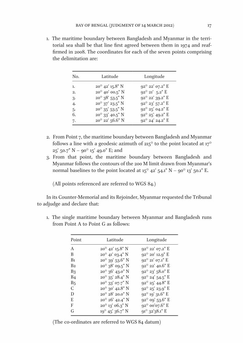
1. The maritime boundary between Bangladesh and Myanmar in the terri-torial sea shall be that line fijirst agreed between them in 1974 and reaf-fijirmed in 2008. The coordinates for each of the seven points comprising the delimitation are:
No. Latitude Longitude
1. 20° 42’ 15.8” N 92° 22’ 07.2” E2. 20° 40’ 00.5” N 92° 21’ 5.2” E3. 20° 38’ 53.5” N 92° 22’ 39.2” E4. 20° 37’ 23.5” N 92° 23’ 57.2” E5. 20° 35’ 53.5” N 92° 25’ 04.2” E6. 20° 33’ 40.5” N 92° 25’ 49.2” E7. 20° 22’ 56.6” N 92° 24’ 24.2” E
2. From Point 7, the maritime boundary between Bangladesh and Myanmar follows a line with a geodesic azimuth of 215° to the point located at 17° 25’ 50.7” N – 90° 15’ 49.0” E; and
3. From that point, the maritime boundary between Bangladesh and Myanmar follows the contours of the 200 M limit drawn from Myanmar’s normal baselines to the point located at 15° 42’ 54.1” N – 90° 13’ 50.1” E.
(All points referenced are referred to WGS 84.)
In its Counter-Memorial and its Rejoinder, Myanmar requested the Tribunal to adjudge and declare that:
1. The single maritime boundary between Myanmar and Bangladesh runs from Point A to Point G as follows:
Point Latitude Longitude
A 20° 42’ 15.8” N 92° 22’ 07.2” EB 20° 41’ 03.4” N 92° 20’ 12.9” EB1 20° 39’ 53.6” N 92° 21’ 07.1” EB2 20° 38’ 09.5” N 92° 22’ 40.6” EB3 20° 36’ 43.0” N 92° 23’ 58.0” EB4 20° 35’ 28.4” N 92° 24’ 54.5” EB5 20° 33’ 07.7” N 92° 25’ 44.8” EC 20° 30’ 42.8” N 92° 25’ 23.9” ED 20° 28’ 20.0” N 92° 19’ 31.6” EE 20° 26’ 42.4” N 92° 09’ 53.6” EF 20° 13’ 06.3” N 92° 00’07.6” EG 19° 45’ 36.7” N 91° 32’38.1” E
(The co-ordinates are referred to WGS 84 datum)
bay of bengal (judgment of 14 march 2012) 17

2. From Point G, the boundary line continues along the equidistance line in a south-west direction following a geodetic azimuth of 231° 37’ 50.9” until it reaches the area where the rights of a third State may be afffected.
The Republic of the Union of Myanmar reserves its right to supplement or to amend these submissions in the course of the present proceedings.
32. In accordance with article 75, paragraph 2, of the Rules, the following fijinal submissions were presented by the Parties during the oral proceedings:
On behalf of Bangladesh, at the hearing on 22 September 2011:
[O]n the basis of the facts and arguments set out in our Reply and during these oral proceedings, Bangladesh requests the Tribunal to adjudge and declare that:
(1) The maritime boundary between Bangladesh and Myanmar in the territorial sea shall be that line fijirst agreed between them in 1974 and reafffijirmed in 2008. The coordinates for each of the seven points compris-ing the delimitation are those set forth in our written Submissions in the Memorial and Reply;
(2) From Point 7, the maritime boundary between Bangladesh and Myanmar follows a line with a geodesic azimuth of 215° to the point located at the coordinates set forth in paragraph 2 of the Submissions as set out in the Reply; and
(3) From that point, the maritime boundary between Bangladesh and Myanmar follows the contours of the 200-M limit drawn from Myanmar’s normal baselines to the point located at the coordinates set forth in para-graph 3 of the Submissions as set out in the Reply.
On behalf of Myanmar, at the hearing on 24 September 2011:
Having regard to the facts and law set out in the Counter-Memorial and the Rejoinder, and at the oral hearing, the Republic of the Union of Myanmar requests the Tribunal to adjudge and declare that:
1. The single maritime boundary between Myanmar and Bangladesh runs from point A to point G, as set out in the Rejoinder. [. . .]
bay of bengal (judgment of 14 march 2012) 18

2. From point G, the boundary line continues along the equidistance line in a south-west direction following a geodetic azimuth of 231° 37’ 50.9” until it reaches the area where the rights of a third State may be afffected.
III. Factual Background
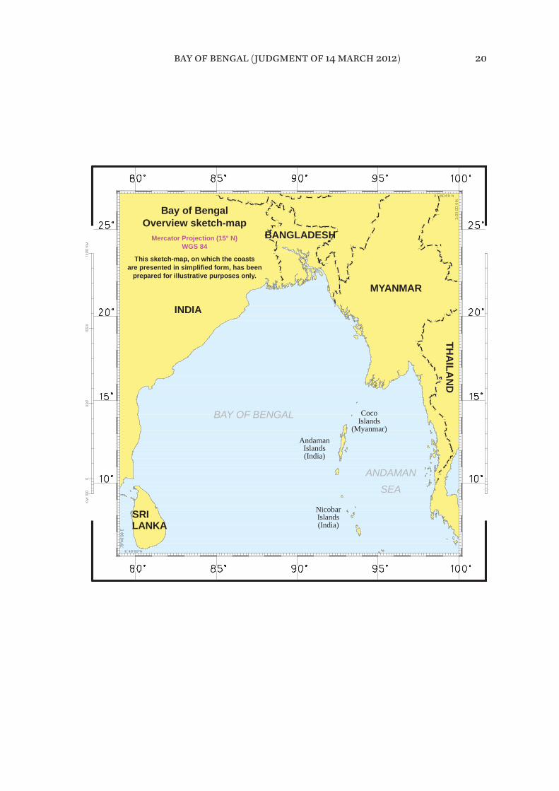
Regional geography (see overview sketch-map on page 20)
33. The maritime area to be delimited in the present case lies in the northeast-ern part of the Bay of Bengal. This Bay is situated in the northeastern Indian Ocean, covering an area of approximately 2.2 million square kilometres, and is bordered by Sri Lanka, India, Bangladesh and Myanmar.
34. Bangladesh is situated to the north and northeast of the Bay of Bengal. Its land territory borders India and Myanmar and covers an area of approximately 147,000 square kilometres.
35. Myanmar is situated to the east of the Bay of Bengal. Its land territory bor-ders Bangladesh, India, China, Laos and Thailand and covers an area of approx-imately 678,000 square kilometres.
bay of bengal (judgment of 14 march 2012) 19
LANKASRI Islands
(India)
are presented in simplified form, has been
BANGLADESH
prepared for illustrative purposes only.
Bay of BengalOverview sketch-map
Mercator Projection (15° N)WGS 84
This sketch-map, on which the coasts
INDIA
BAY OF BENGAL
Nicobar
(India)Islands
Andaman
MYANMAR
THA
ILAN
D
ANDAMANSEA
CocoIslands
(Myanmar)
bay of bengal (judgment of 14 march 2012) 20
Brief history of the negotiations between the Parties
36. Prior to the institution of these proceedings, negotiations on the delimita-tion of the maritime boundary were held between Bangladesh and Myanmar from 1974 to 2010. Eight rounds of talks took place between 1974 and 1986 and six rounds between 2008 and 2010.
37. During the second round of talks, held in Dhaka between 20 and 25 November 1974, the heads of the two delegations, on 23 November 1974, signed the “Agreed Minutes between the Bangladesh Delegation and the Burmese Delegation regarding the Delimitation of the Maritime Boundary between the Two Countries” (hereinafter “the 1974 Agreed Minutes”; see paragraph 57).
38. On the resumption of the talks in 2008, at the fijirst round held in Dhaka from 31 March to 1 April 2008, the heads of delegations on 1 April 2008, signed the “Agreed Minutes of the meeting held between the Bangladesh Delegation and the Myanmar Delegation regarding the delimitation of the Maritime Boundaries between the two countries” (hereinafter “the 2008 Agreed Minutes”; see para-graph 58).
39. In the summary of discussions signed by the heads of the delegations at the fijifth round, held in Chittagong on 8 and 9 January 2010, it was noted that Bangladesh had already initiated arbitration proceedings under Annex VII to the Convention.
IV. Subject-matter of the dispute
40. The dispute concerns the delimitation of the maritime boundary between Bangladesh and Myanmar in the Bay of Bengal with respect to the territorial sea, the exclusive economic zone and the continental shelf.
V. Jurisdiction
41. Bangladesh observes that the Parties have expressly recognized the jurisdic-tion of the Tribunal over the dispute, as reflected in their declarations made under article 287. It states that “the subject-matter of the dispute is exclusively concerned with the provisions of UNCLOS and thus falls entirely within ITLOS jurisdiction as agreed by the parties”.
bay of bengal (judgment of 14 march 2012) 21
42. Bangladesh asserts that its “claim is based on the provisions of UNCLOS as applied to the relevant facts, including but not limited to UNCLOS Articles 15, 74, 76 and 83” and that “[t]hese provisions relate to the delimitation of the ter-ritorial sea, exclusive economic zone and continental shelf, including the outer continental shelf beyond 200” nautical miles (hereinafter “nm”).
43. Bangladesh states that the Tribunal’s jurisdiction to delimit the maritime boundary between Bangladesh and Myanmar in respect of all the maritime areas in dispute, including the part of the continental shelf beyond 200 nm from the baselines from which the breadth of the territorial sea is measured (herein-after “the continental shelf beyond 200 nm”) is recognized under the Convention and concludes that the Tribunal’s jurisdiction in regard to the dispute between Bangladesh and Myanmar is plainly established.
44. Myanmar notes that the two Parties in their declarations under article 287, paragraph 1, of the Convention accepted the jurisdiction of the Tribunal to settle the dispute relating to the delimitation of their maritime boundary in the Bay of Bengal. It states that the dispute before this Tribunal concerns the delimita-tion of the territorial sea, the exclusive economic zone and the continental shelf of Myanmar and Bangladesh in the Bay of Bengal.
45. Myanmar does not dispute that, “as a matter of principle, the delimitation of the continental shelf, including the shelf beyond 200 [nm], could fall within the jurisdiction of the Tribunal”. However, it submits that “in the present case, the Tribunal does not have jurisdiction with regard to the continental shelf beyond 200 [nm]”. In this regard Myanmar contends that, even if the Tribunal were to decide that it has jurisdiction to delimit the continental shelf beyond 200 nm, it would not be appropriate for the Tribunal to exercise that jurisdiction in the present case.
* * *46. The Tribunal notes that Bangladesh and Myanmar are States Parties to the Convention. Bangladesh ratifijied the Convention on 27 July 2001 and the Convention entered into force for Bangladesh on 26 August 2001. Myanmar rat-ifijied the Convention on 21 May 1996 and the Convention entered into force for Myanmar on 20 June 1996.
bay of bengal (judgment of 14 march 2012) 22
47. The Tribunal observes that Myanmar and Bangladesh, by their declarations under article 287, paragraph 1, of the Convention, quoted in paragraphs 3 and 4, accepted the jurisdiction of the Tribunal for the settlement of the dispute between them relating to the delimitation of their maritime boundary in the Bay of Bengal and that these declarations were in force at the time proceedings before the Tribunal were instituted on 14 December 2009.
48. Pursuant to article 288, paragraph 1, of the Convention and article 21 of the Statute, the jurisdiction of the Tribunal comprises all disputes and all applica-tions submitted to it in accordance with the Convention. In the view of the Tribunal, the present dispute entails the interpretation and application of the relevant provisions of the Convention, in particular articles 15, 74, 76 and 83 thereof.
49. The Tribunal further observes that the Parties agree that the Tribunal has jurisdiction to adjudicate the dispute relating to the delimitation of the territo-rial sea, the exclusive economic zone and the continental shelf within 200 nm from the baselines from which the breadth of the territorial sea is measured (hereinafter “the continental shelf within 200 nm”).
50. Accordingly, the Tribunal concludes that it has jurisdiction to delimit the maritime boundary between the Parties in the territorial sea, the exclusive eco-nomic zone and the continental shelf within 200 nm. The Tribunal will deal with the issue of its jurisdiction with respect to the delimitation of the continental shelf beyond 200 nm in paragraphs 341-394.
VI. Applicable law
51. Article 23 of the Statute states: “The Tribunal shall decide all disputes and applications in accordance with article 293” of the Convention.
52. Article 293, paragraph 1, of the Convention states: “A court or tribunal hav-ing jurisdiction under this section shall apply this Convention and other rules of international law not incompatible with this Convention”.
53. The Parties agree that the applicable law is the Convention and other rules of international law not incompatible with it.
bay of bengal (judgment of 14 march 2012) 23
54. Articles 15, 74 and 83 of the Convention establish the law applicable to the delimitation of the territorial sea, the exclusive economic zone and the conti-nental shelf, respectively. As the present case relates, inter alia, to the delimita-tion of the continental shelf, article 76 of the Convention is also of particular importance.
55. The provisions of articles 15, 74, 76 and 83 of the Convention will be exam-ined by the Tribunal in the relevant sections of this Judgment relating to the delimitation of the territorial sea, the exclusive economic zone and the conti-nental shelf.
VII. Territorial sea
56. In dealing with the delimitation of the territorial sea, the Tribunal will fijirst address the issue of whether the Parties have in fact delimited their territorial sea, either by signing the Agreed Minutes of 1974 and 2008 or by tacit agree-ment. The Tribunal will also examine whether the conduct of the Parties may be said to have created a situation of estoppel.
The 1974 and 2008 Agreed Minutes
57. As noted in paragraph 36, the Parties held discussions from 1974 to 2010 on the delimitation of maritime areas between them, including the territorial sea. During the second round of these discussions, the head of the delegation of Burma (now the Republic of the Union of Myanmar), Commodore Chit Hlaing, and the head of the Bangladesh delegation, Ambassador K.M. Kaiser, signed the 1974 Agreed Minutes which read as follows:
Agreed Minutes between the Bangladesh Delegation and the Burmese
Delegation regarding the Delimitation of the Maritime Boundary between the
Two Countries
1. The delegations of Bangladesh and Burma held discussions on the ques-tion of delimiting the maritime boundary between the two countries in Rangoon (4 to 6 September 1974) and in Dacca (20 to 25 November 1974). The discussions took place in an atmosphere of great cordiality, friendship and mutual understanding.
bay of bengal (judgment of 14 march 2012) 24

2. With respect to the delimitation of the fijirst sector of the maritime bound-ary between Bangladesh and Burma, i.e., the territorial waters boundary, the two delegations agreed as follows:
I. The boundary will be formed by a line extending seaward from Boundary Point No. 1 in the Naaf River to the point of intersection of arcs of 12 [nm] from the southernmost tip of St. Martin’s Island and the nearest point on the coast of the Burmese mainland, connecting the intermediate points, which are the mid-points between the nearest points on the coast of St. Martin’s Island and the coast of the Burmese mainland.
The general alignment of the boundary mentioned above is illustrated on Special Chart No. 114 annexed to these minutes.
II. The fijinal coordinates of the turning points for delimiting the boundary of the territorial waters as agreed above will be fijixed on the basis of the data collected by a joint survey.
3. The Burmese delegation in the course of the discussions in Dacca stated that their Government’s agreement to delimit the territorial waters bound-ary in the manner set forth in para 2 above is subject to a guarantee that Burmese ships would have the right of free and unimpeded navigation through Bangladesh waters around St. Martin’s Island to and from the Burmese sector of the Naaf River.
4. The Bangladesh delegation expressed the approval of their Government regarding the territorial waters boundary referred to in para 2. The Bangladesh delegation had taken note of the position of the Burmese Government regarding the guarantee of free and unimpeded navigation by Burmese vessels mentioned in para 3 above.
5. Copies of a draft Treaty on the delimitation of the territorial waters boundary were given to the Burmese delegation by the Bangladesh delega-tion on 20 November 1974 for eliciting views from the Burmese Government.
6. With respect to the delimitation of the second sector of the Bangladesh-Burma maritime boundary, i.e., the Economic Zone and Continental Shelf boundary, the two delegations discussed and considered various principles and rules applicable in that regard. They agreed to continue discussions in the matter with a view to arriving at a mutually acceptable boundary.
bay of bengal (judgment of 14 march 2012) 25
(Signed) (Signed)(Commodore Chit Hlaing) (Ambassador K.M. Kaiser)Leader of the Burmese Leader of the BangladeshDelegation DelegationDated, November 23, 1974. Dated, November 23, 1974.
58. During the fijirst round of the resumed discussions, the head of the Myanmar delegation, Commodore Maung Oo Lwin, and the head of the Bangladesh del-egation, Mr M.A.K. Mahmood, Additional Foreign Secretary, signed the 2008 Agreed Minutes, which read as follows:
Agreed Minutes of the meeting held between the Bangladesh Delegation and
the Myanmar Delegation regarding the delimitation of the Maritime Boundaries
between the two countries
1. The Delegations of Bangladesh and Myanmar held discussions on the delimitation of the maritime boundary between the two countries in Dhaka from 31 March to 1st April, 2008. The discussions took place in an atmo-sphere of cordiality, friendship and understanding.
2. Both sides discussed the ad-hoc understanding on chart 114 of 1974 and both sides agreed ad-referendum that the word “unimpeded” in paragraph 3 of the November 23, 1974 Agreed Minutes, be replaced with “Innocent Passage through the territorial sea shall take place in conformity with the UNCLOS, 1982 and shall be based on reciprocity in each other’s waters”.
3. Instead of chart 114, as referred to in the ad-hoc understanding both sides agreed to plot the following coordinates as agreed in 1974 of the ad-hoc understanding on a more recent and internationally recognized chart, namely, Admiralty Chart No. 817, conducting joint inspection instead of pre-viously agreed joint survey:
bay of bengal (judgment of 14 march 2012) 26

Serial No. Latitude Longitude
1. 20° -42’ -12.3” N 092° -22’ -18” E2. 20° -39’ -57” N 092° -21’ -16” E3. 20° -38’ -50” N 092° -22’ -50” E4. 20° -37’ -20” N 092° -24’ -08” E5. 20° -35’ -50” N 092° -25’ -15” E6. 20° -33’ -37” N 092° -26’ -00” E7. 20° -22’ -53” N 092° -24’ -35” E
Other terms of the agreed minutes of the 1974 will remain the same.
4. As a starting point for the delimitation of the EEZ and Continental Shelf, Bangladesh side proposed the intersecting point of the two 12 [nm] arcs (Territorial Sea limits from respective coastlines) drawn from the southern-most point of St. Martin’s Island and Myanmar mainland as agreed in 1974, or any point on the line connecting the St. Martin’s Island and Oyster Island after giving due efffect i.e. 3:1 ratio in favour of St. Martin’s Island to Oyster Island. Bangladesh side referred to the Article 121 of the UNCLOS, 1982 and other jurisprudence regarding status of islands and rocks and Oyster Island is not entitled to EEZ and Continental Shelf. Bangladesh side also reiterated about the full efffects of St. Martin’s Island as per regime of Islands as stipu-lated in Article 121 of the UNCLOS, 1982.
5. Myanmar side proposed that the starting point for the EEZ and Continental Shelf could be the mid point on the line connecting the St. Martin’s Island and Oyster Island. Myanmar side referred to Article 7(4), 15, 74, 83 and cited relevant cases and the fact that proportionality of the two coastlines should be considered. Myanmar also stated that Myanmar has given full efffect to St. Martin’s Island which was opposite to Myanmar main-land and that Oyster Island should enjoy full efffect, since it has inhabitants and has a lighthouse, otherwise, Myanmar side would need to review the full-efffect that it had accorded to St. Martin’s Island.
bay of bengal (judgment of 14 march 2012) 27
6. The two sides also discussed and considered various equitable principles and rules applicable in maritime delimitation and State practices.
7. They agreed to continue discussions in the matter with a view to arriving at a mutually acceptable maritime boundary in Myanmar at mutually con-venient dates.
(Signed) (Signed)Commodore Maung Oo Lwin M.A.K. MahmoodLeader of the Myanmar Delegation Additional Foreign SecretaryLeader of the Bangladesh Delegation Dated: April 1, 2008 Dhaka
59. The Tribunal will now consider the position of the Parties on the Agreed Minutes.
60. In its fijinal submissions Bangladesh requests the Tribunal to adjudge and declare, inter alia, that the maritime boundary between Bangladesh and Myanmar in the territorial sea shall be the line fijirst agreed between them in 1974 and reafffijirmed in 2008.
61. According to Bangladesh, the Parties reached agreement in November 1974, at their second round of negotiations. It maintains that the two delegations con-fijirmed the terms of their agreement and gave it clear expression by jointly plot-ting the agreed line on Special Chart No. 114, which was signed by the heads of both delegations. It also observes that, subsequently, “the Parties’ agreement was reduced to writing” in the form of the 1974 Agreed Minutes.
62. Bangladesh recalls that, during the negotiations in 1974, it presented a draft treaty to Myanmar. Bangladesh states that Myanmar did not sign this document, not because it disagreed with the line, but because it preferred to incorporate the Parties’ agreement into a comprehensive maritime delimitation treaty including the exclusive economic zone and the continental shelf.
63. According to Bangladesh, “[i]n the years that followed, the territorial sea was treated as a settled issue by both Parties”, and “[n]either Party raised any concerns or suggested a diffferent approach”. It states that “[o]nly in September 2008, 34 years after the adoption of the 1974 agreement, did Myanmar for the fijirst time suggest that the agreement was no longer in force”.
bay of bengal (judgment of 14 march 2012) 28

64. In the view of Bangladesh, the 1974 Agreed Minutes were “intended to be and [are] valid, binding, and efffective”. Bangladesh states that these Minutes created rights and obligations on both States and therefore constitute an “agree-ment” within the meaning of article 15 of the Convention. Bangladesh adds that “[i]ndeed, the Agreed Minutes of 1974 specifijically use that very term in referring to Myanmar’s ‘agreement’ to the delimitation of the territorial sea”. For similar reasons, Bangladesh considers that the 2008 Agreed Minutes also embody an agreement of a binding nature.
65. For its part, Myanmar denies the existence of an agreement between the Parties within the meaning of article 15 of the Convention, arguing that it is clear from both “the form and the language” of the 1974 Agreed Minutes that “the so-called ‘1974 Agreement’ ” between the two delegations was merely an under-standing reached at a certain stage of the technical-level talks as part of the ongoing negotiations. In its view it was without doubt intended that Points 1 to 7 would in due course be included in an overall agreement on the delimitation of the entire line between the maritime areas appertaining to Myanmar and those appertaining to Bangladesh. Myanmar maintains that no such agreement had been reached.
66. According to Myanmar, the 1974 Agreed Minutes were nothing more than a conditional agreement reached at the level of the negotiators. Myanmar empha-sizes that its delegation made clear on several occasions that its Government would not sign and ratify a treaty that did not resolve the delimitation dispute in all the diffferent contested areas altogether and that its position was that no agreement would be concluded on the territorial sea before there was agree-ment regarding the exclusive economic zone/continental shelf. It adds that Bangladesh was fully aware of Myanmar’s position on this point.
67. Myanmar contends that the conditionality of the understanding contained in the 1974 Agreed Minutes is inconsistent with Bangladesh’s assertion that this instrument has binding force. According to Myanmar, the ad hoc understanding was subject to two conditions:
First, paragraph 2 made the understanding between the delegations subject to “a guarantee that Burmese ships would have the right of free and unim-peded navigation through Bangladesh waters around St. Martin’s Island to and from the Burmese sector of the Naaf River”. Paragraph 4 then merely stated that “[t]he Bangladesh delegation had taken note of the position of the Burmese Government regarding the guarantee of free and unimpeded
bay of bengal (judgment of 14 march 2012) 29

navigation by Burmese vessels mentioned in para 3 above”. [. . .] The issue was left for future negotiation and settlement. [. . .]
The second and crucial condition in the text is found in paragraphs 4 and 5 of the minutes. According to paragraph 4, “[t]he Bangladesh delegation expressed the approval of their Government regarding the territorial waters boundary referred to in para 2”. The paragraph, however, was silent with respect to approval of the Government of Myanmar to any such boundary. Paragraph 5 then stated that “Copies of a draft Treaty on the delimitation of territorial waters boundary were given to the Burmese delegation by the Bangladesh delegation on 20 November 1974 for eliciting views from the Burmese Government”.
68. In addition, Myanmar observes that the 1974 Agreed Minutes were not approved in conformity with the constitutional provisions in force in either of the two countries.
69. In Myanmar’s view, case law shows that a delimitation agreement is not lightly to be inferred. In support of this, Myanmar refers to the case concerning Territorial and Maritime Dispute between Nicaragua and Honduras in the
Caribbean Sea (Nicaragua v. Honduras) ( Judgment, I.C.J. Reports 2007, p. 659, at p. 735, para. 253).
Use of the term “agreement” in article 15 of the Convention
70. Bangladesh maintains that an “agreement” in accordance with article 15 of the Convention must not necessarily be “in every sense a formally negotiated and binding treaty”.
71. Myanmar emphasizes that “what is contemplated is an agreement that is binding in international law”. It argues that the question therefore is whether the 1974 Agreed Minutes constitute an agreement binding under international law, in other words a treaty, and whether by their terms they established a mar-itime delimitation.
bay of bengal (judgment of 14 march 2012) 30
Terms of the “Agreed Minutes” and circumstances of their adoption
72. In support of its position that the 1974 Agreed Minutes reflect a binding agreement, Bangladesh claims that their terms are “clear and unambiguous” and “[t]heir ordinary meaning is that a boundary has been agreed”. According to Bangladesh, “[t]he text clearly identifijies a boundary located midway between St. Martin’s Island and the coast of Myanmar, from points 1-7 as shown on Special Chart 114”. Bangladesh maintains that the terms of the 1974 Agreed Minutes were confijirmed by the delegations of the Parties when they jointly plot-ted the agreed line on that chart. Moreover, it observes that the object and pur-pose of the agreement and the context in which it was negotiated are also clear, namely, “to negotiate a maritime boundary”. It adds that the existence of an agreement is also evidenced by the terminology used, namely “Agreed Minutes”.
73. Bangladesh contends that the terms of the 1974 Agreed Minutes were con-fijirmed by the 2008 Agreed Minutes and remained the same, subject only to two minor alterations. The fijirst modifijication in the 2008 Agreed Minutes consisted in plotting the “coordinates as agreed in 1974 of the ad hoc understanding on a more recent and internationally recognized chart, namely Admiralty Chart No. 817”. The second modifijication was to replace the phrase “unimpeded access” in paragraph 3 of the 1974 Agreed Minutes with the phrase: “Innocent passage through the territorial sea shall take place in conformity with the UNCLOS 1982, and shall be based on reciprocity in each other’s waters”.
74. Bangladesh adds that the 1974 Agreed Minutes are “very similar or identical to the procès-verbal in the Black Sea case”, since they “both record an agreement negotiated by offfijicials with power to conclude agreements in simplifijied form in accordance with article 7(1)(b) of the Vienna Convention [on the Law of Treaties]”.
75. Myanmar responds that the expression “Agreed Minutes” is often employed in international relations “for the record of a meeting” and “it is not a common designation for a document that the participants intend to constitute a treaty”. Myanmar notes that the full title of the 1974 Agreed Minutes is “Agreed Minutes between the Bangladesh Delegation and the Burmese Delegation regarding the Delimitation of the Maritime Boundary between the Two Countries”, emphasiz-ing that the 1974 Agreed Minutes were concluded “between the Bangladesh Delegation and the Burmese Delegation”. According to Myanmar, “[a] legally binding treaty between two sovereign States would hardly be expressed, in its
bay of bengal (judgment of 14 march 2012) 31

title, to be between delegations”. Myanmar makes similar remarks with regard to the 2008 Agreed Minutes.
76. Myanmar argues that the “ordinary language” indicates that the 1974 Agreed Minutes “were never intended to constitute a legally binding agreement”. In par-ticular, Myanmar observes that the opening words in paragraph 1 of these Minutes “are clearly the language of a record of a meeting, not of a legally bind-ing agreement”. It states that paragraph 2 of the 1974 Agreed Minutes only relates to “ ‘the fijirst sector of the maritime boundary’, implying that more sectors must be negotiated before a fijinal agreement is reached” and records that the two delegations agreed that the boundary would be formed by a line. Paragraph 4 states that the “Bangladesh delegation” has “taken note” of the position of the Government of Myanmar “regarding the guarantee of free and unimpeded nav-igation”. Paragraph 6 indicates that the discussions concerning the maritime boundary in the exclusive economic zone and the continental shelf remained ongoing.
77. Referring to the terms of the 2008 Agreed Minutes, Myanmar observes that “once again the language is that of a record of discussion, not of treaty commit-ments”. It further observes that the text of the 2008 Agreed Minutes also coun-ters Bangladesh’s assertion as they refer to the 1974 Agreed Minutes as “an ad-hoc understanding”. Moreover, the wording in paragraph 2 of the 2008 Agreed Minutes that “both sides agreed ad referendum” indicates that “the two delega-tions intended to refer the matter back to their respective governments”.
78. Myanmar argues that the circumstances in which the 1974 Agreed Minutes and 2008 Agreed Minutes were concluded “confijirm that the Minutes were no more than an ad hoc conditional understanding, reached at an initial stage of the negotiations, which never ripened into a binding agreement between the two negotiating sides”.
79. Myanmar adds that the 1974 Agreed Minutes are by no means comparable to the 1949 General Procès-Verbal that was at issue in the case concerning Maritime Delimitation in the Black Sea (Romania v. Ukraine) ( Judgment, I.C.J.
Reports 2009, p. 61). Pointing to what it says are essential diffferences between the two instruments, Myanmar contends that the actual terms and context of the 1949 General Procès-Verbal are entirely diffferent from those of the 1974 Agreed Minutes and points out that the parties to the 1949 General Procès-Verbal were in agreement that it was a legally binding international agreement.
bay of bengal (judgment of 14 march 2012) 32

Full powers
80. Regarding the question of the authority of Myanmar’s delegation, Bangladesh considers that the head of the Burmese delegation who signed the 1974 Agreed Minutes was the appropriate offfijicial to negotiate with Bangladesh in 1974 and “did not require full powers to conclude an agreement in simplifijied form”. Bangladesh argues that, even if the head of the Burmese delegation lacked the authority to do so, the agreement remains valid “if it [was] afterwards confijirmed by the State concerned” in accordance with article 8 of the Vienna Convention on the Law of Treaties (hereinafter “the Vienna Convention”). In this respect Bangladesh holds the view that the 1974 Agreed Minutes “were confijirmed and re-adopted in 2008”.
81. According to Bangladesh:
[w]hat matters is whether the Parties have agreed on a boundary, even in simplifijied form, not whether their agreement is a formally negotiated treaty or has been signed by representatives empowered to negotiate or ratify the treaty.
82. Bangladesh points out that, in the case concerning Land and Maritime
Boundary between Cameroon and Nigeria (Cameroon v. Nigeria: Equatorial
Guinea intervening) ( Judgment, I.C.J. Reports 2002, p. 303, at p. 429, para. 263), the International Court of Justice (hereinafter “the ICJ”) “held that the Maroua Declaration constituted an international agreement in written form tracing a boundary and that it was thus governed by international law and constituted a treaty in the sense of the 1969 Vienna Convention on the Law of Treaties”.
83. Myanmar argues that members of its delegation to the negotiations in November 1974 lacked authority “to commit their Government to a legally-bind-ing treaty”. It states, in this regard, that the head of the Burmese delegation, Commodore Hlaing, a naval offfijicer, could not be considered as representing Myanmar for the purpose of expressing its consent to be bound by a treaty as he was not one of those holders of high-ranking offfijice in the State referred to in article 7, paragraph 2, of the Vienna Convention. Furthermore, the circumstances described in article 7, paragraph 1, of the Vienna Convention do not apply in the present case since Commodore Hlaing did not have full powers issued by the Government of Myanmar and there were no circumstances to suggest that it was the intention of Myanmar and Bangladesh to dispense with full powers.
bay of bengal (judgment of 14 march 2012) 33
84. In the view of Myanmar, under article 8 of the Vienna Convention an act by a person who cannot be considered as representing a State for the purposes of concluding a treaty is without legal efffect unless afterwards confijirmed by that State. Myanmar adds that what has to be confijirmed is the act of the unauthor-ised person and submits that this act by itself has no legal efffect and states that “[i]t does not establish an agreement that is voidable”. It states further that this is “clear from the very fact that article 8 is placed in Part II of the Vienna Convention on the conclusion and entry into force of treaties, and not in Part V” on invalidity, termination and suspension of the operation of treaties.
85. According to Myanmar, the present case is not comparable to the case con-cerning Land and Maritime Boundary between Cameroon and Nigeria (Cameroon
v. Nigeria: Equatorial Guinea intervening). Referring to that case, Myanmar states: “the ICJ found that the Maroua Declaration constituted an international agree-ment because the recognised elements of what constitutes a treaty were met, in particular, the consent of both Nigeria and Cameroon to be bound by the Maroua Declaration. The signatures of the Heads of State of both countries were clearly sufffijicient to express their consent to be bound. That is not our case”.
Registration
86. Myanmar argues that the fact that the 1974 and the 2008 Agreed Minutes were not registered with the Secretary-General of the United Nations, as required by article 102, paragraph 1, of the United Nations Charter, is another indication that the Parties “did not consider either the 1974 or the 2008 minutes to be a binding agreement”. It adds that neither Party publicized nor submitted charts or lists of co-ordinates of the points plotted in the Agreed Minutes with the Secretary-General of the United Nations, as required by article 16, paragraph 2, of the Convention. Myanmar states that while such submission, or the absence thereof, is not conclusive, it provides a further indication of the intention of Bangladesh and Myanmar with respect to the status of the minutes.
87. Bangladesh, in response, cites the judgment in the case concerning Maritime
Delimitation and Territorial Questions between Qatar and Bahrain, in which the ICJ stated: “Non-registration or late registration, on the other hand, does not have any consequence for the actual validity of the agreement, which remains no less binding upon the parties” ( Jurisdiction and Admissibility, Judgment, I.C.J.
Reports 1994, p. 112, at p. 122, para. 29).
bay of bengal (judgment of 14 march 2012) 34

* * *88. The Tribunal will now address the question whether the 1974 Agreed Minutes constitute an agreement within the meaning of article 15 of the Convention.
89. The Tribunal notes that, in light of the object and purpose of article 15 of the Convention, the term “agreement” refers to a legally binding agreement. In the view of the Tribunal, what is important is not the form or designation of an instrument but its legal nature and content.
90. The Tribunal recalls that in the “Hoshinmaru” case it recognized the possi-bility that agreed minutes may constitute an agreement when it stated that “[t]he Protocol or minutes of a joint commission such as the Russian-Japanese Commission on Fisheries may well be the source of rights and obligations between Parties” (“Hoshinmaru” ( Japan v. Russian Federation), Prompt Release,
Judgment, ITLOS Reports 2007, p. 18, at p. 46, para. 86). The Tribunal also recalls that in the case concerning Maritime Delimitation and Territorial Questions
between Qatar and Bahrain, the ICJ observed that “international agreements may take a number of forms and be given a diversity of names” and that agreed minutes may constitute a binding agreement. ( Jurisdiction and Admissibility,
Judgment, I.C.J. Reports 1994, p. 112, at p. 120, para. 23).
91. The Tribunal must decide whether, in the circumstances of the present case, the 1974 Agreed Minutes constitute such an agreement.
92. The Tribunal considers that the terms of the 1974 Agreed Minutes confijirm that these Minutes are a record of a conditional understanding reached during the course of negotiations, and not an agreement within the meaning of article 15 of the Convention. This is supported by the language of these Minutes, in particular, in light of the condition expressly contained therein that the delimi-tation of the territorial sea boundary was to be part of a comprehensive mari-time boundary treaty.
93. The Tribunal notes that the circumstances in which the 1974 Agreed Minutes were adopted do not suggest that they were intended to create legal obligations or embodied commitments of a binding nature. From the beginning of the dis-cussions Myanmar made it clear that it did not intend to enter into a separate agreement on the delimitation of territorial sea and that it wanted a compre-hensive agreement covering the territorial sea, the exclusive economic zone and the continental shelf.
bay of bengal (judgment of 14 march 2012) 35
94. In this context, the Tribunal further points out that in the report prepared by Bangladesh on the second round of negotiations held on 25 November 1974 in Dhaka, it is stated that:
7. Copies of a Draft Treaty on the delimitation of territorial waters boundary were given to the Burmese delegation by the Bangladesh delegation on November 20, 1974 for eliciting views from the Burmese Government. The initial reaction of the Burmese side was that they were not inclined to con-clude a separate treaty/agreement on the delimitation of territorial waters; they would like to conclude a single comprehensive treaty where the bound-aries of territorial waters and continental shelf were incorporated.
95. In the view of the Tribunal, the delimitation of maritime areas is a sensitive issue. The Tribunal concurs with the statement of the ICJ that “[t]he establish-ment of a permanent maritime boundary is a matter of grave importance and agreement is not easily to be presumed” (Territorial and Maritime Dispute
between Nicaragua and Honduras in the Caribbean Sea (Nicaragua v. Honduras), Judgment, I.C.J. Reports 2007, p. 659, at p. 735, para. 253).
96. On the question of the authority to conclude a legally binding agreement, the Tribunal observes that, when the 1974 Agreed Minutes were signed, the head of the Burmese delegation was not an offfijicial who, in accordance with article 7, paragraph 2, of the Vienna Convention, could engage his country without hav-ing to produce full powers. Moreover, no evidence was provided to the Tribunal that the Burmese representatives were considered as having the necessary authority to engage their country pursuant to article 7, paragraph 1, of the Vienna Convention. The Tribunal notes that this situation difffers from that of the Maroua Declaration which was signed by the two Heads of State concerned.
97. The fact that the Parties did not submit the 1974 Agreed Minutes to the procedure required by their respective constitutions for binding international agreements is an additional indication that the Agreed Minutes were not intended to be legally binding.
98. For these reasons, the Tribunal concludes that there are no grounds to con-sider that the Parties entered into a legally binding agreement by signing the 1974 Agreed Minutes. The Tribunal reaches the same conclusion regarding the 2008 Agreed Minutes since these Minutes do not constitute an independent commitment but simply reafffijirm what was recorded in the 1974 Agreed Minutes.
bay of bengal (judgment of 14 march 2012) 36
99. In light of the foregoing, the Tribunal does not fijind it necessary to address the relevance, if any, of the lack of registration of the 1974 Agreed Minutes as required by article 102, paragraph 1, of the United Nations Charter or of the fail-ure to deposit charts or lists of geographical coordinates with the Secretary-General of the United Nations as provided in article 16, paragraph 2, of the Convention.
Tacit or de facto agreement
100. The Tribunal will now consider whether the conduct of the Parties evi-dences a tacit or de facto agreement relating to the boundary in the territorial sea.
101. Bangladesh contends that the fact that the Parties have conducted them-selves in accordance with the agreed delimitation for over three decades dem-onstrates the existence of a tacit or de facto agreement as to the boundary line in the territorial sea. In support of its position, Bangladesh argues that each Party “exercised peaceful and unchallenged administration and control over its agreed territorial sea” and that, in reliance on the existing agreement, Bangladesh permitted Myanmar’s vessels to “navigate freely” through its waters in the vicin-ity of St. Martin’s Island to reach the Naaf River.
102. In order to illustrate both Parties’ commitment to the 1974 line, Bangladesh states that its coastal fijishermen have relied on that line in conducting their fijish-ing activities in the areas between St. Martin’s Island and the Myanmar coast. It has submitted afffijidavits from fijishermen attesting to the fact that they believe there is an agreed boundary between the Parties in the territorial sea, and that this is located approximately midway between St. Martin’s and Myanmar’s mainland coast. It states that, as a result, they have confijined their fijishing activ-ities to the Bangladesh side of the boundary and carried the national flag of Bangladesh onboard, adding that some of them have also testifijied to the fact that they have had their vessels intercepted by the Myanmar Navy when their boats accidentally strayed across the agreed line.
103. Moreover, Bangladesh points out that it has submitted afffijidavits recount-ing the activities of its naval vessels and aerial patrols and other activities car-ried out by its Navy and Coast Guard to the west of the agreed line.
bay of bengal (judgment of 14 march 2012) 37

104. In the same vein, Bangladesh refers to the Parties’ actions in replotting the 1974 line onto a more up-to-date chart, namely, British Admiralty Chart No. 817(INT 7430) (hereinafter “Admiralty Chart 817”).
105. Regarding the statement made by Myanmar’s Minister of Foreign Afffairs and head of its delegation during the negotiations between the Parties in November 1985, Bangladesh observes that in the Minister’s statement, “far from repudiating a supposedly unauthorized deal negotiated in 1974, he referred to the Minutes signed in Dhaka with approval”.
106. With reference to the note verbale of Myanmar dated 16 January 2008, by which Myanmar notifijied Bangladesh of its intention to carry out survey work on both sides of the boundary, Bangladesh states: “Why would Myanmar seek Bangladesh’s consent if it regarded the whole area as falling within Myanmar’s territorial sea? Its conduct in 2008 amounts to an acknowledgment of Bangladesh’s sovereignty over the territorial sea up to the median line, and its own note verbale even made express reference to the 1974 Agreed Minutes in that context”.
107. Myanmar contends that the conduct of the Parties, including the signing of the 1974 Agreed Minutes by the heads of their delegations, has not established a tacit or de facto agreement between them with respect to the delimitation of the territorial sea. Myanmar further contends that it never acquiesced in any delimitation in the territorial sea. In its view, “Bangladesh puts forward no evi-dence to demonstrate its assertion that the parties have administered their waters in accordance with the agreed minutes, or that Myanmar’s vessels have enjoyed the right of free and unimpeded navigation in the waters around St. Martin’s Island, in accordance with the agreed minutes”. If any such practice existed, Myanmar argues, “it existed regardless of the understandings reached in 1974”.
108. In this connection, Myanmar notes that, during the negotiations between the Parties, Commodore Hlaing, who was the head of the Burmese delegation, reminded his counterpart that the passage of Myanmar vessels in the waters surrounding St. Martin’s Island “was a routine followed for many years by Burmese naval vessels to use the channel [. . .]. He added that in asking for unimpeded navigation the Burmese side was only asking for existing rights which it had been exercising since 1948”.
bay of bengal (judgment of 14 march 2012) 38

109. Myanmar states that the afffijidavits of naval offfijicers and fijishermen produced by Bangladesh cannot be considered as containing relevant evidence in the present case. It further states that the naval offfijicers, offfijicials of Bangladesh, have a clear interest in supporting the position of Bangladesh on the location of the maritime boundary. In this regard, Myanmar relies on case law, namely the deci-sions in the case concerning Military and Paramilitary Activities in and against
Nicaragua (Nicaragua v. United States of America) (Merits, Judgment, I.C.J.
Reports 1986, p. 14, at p. 42, para. 68) and the case concerning Armed Activities on
the Territory of the Congo (Democratic Republic of the Congo v. Uganda) ( Judgment, I.C.J. Reports 2005, p. 168, at pp. 218-219, para. 129), and makes refer-ence, in particular, to the case concerning Territorial and Maritime Dispute
between Nicaragua and Honduras in the Caribbean Sea (Nicaragua v. Honduras) ( Judgment, I.C.J. Reports 2007, p. 659, at p. 731, para. 243).
110. Myanmar further points out that its Minister of Foreign Afffairs, in his state-ment made in Rangoon on 19 November 1985, reiterated Myanmar’s position that what was clearly implied in the text of the Agreed Minutes was that the delimitation of the territorial sea on the one hand and the exclusive economic zone and the continental shelf on the other hand, should be settled together in a single instrument.
111. With regard to its note verbale of 16 January 2008, referred to by Bangladesh, Myanmar contends that Bangladesh ignores the terms of that note. It points out that the note verbale stated that, as States Parties to the Convention, Bangladesh and Myanmar are both entitled to a 12 nm territorial sea “in principle” and also that St. Martin’s Island enjoys such territorial sea “in principle in accordance with UNCLOS, 1982”. Myanmar argues that the note verbale was “explicitly a request for cooperation, not for consent” and that it refrained from relying upon the agreed boundary. Myanmar therefore is of the view that, contrary to Bangladesh’s assertion, the note verbale is entirely consistent with Myanmar’s position on these matters.
* * *
112. The Tribunal will fijirst address the issue of afffijidavits submitted by Bangladesh. In this context, the Tribunal recalls the decision in the case concerning Territorial
and Maritime Dispute between Nicaragua and Honduras in the Caribbean Sea
(Nicaragua v. Honduras), where it is stated that:
bay of bengal (judgment of 14 march 2012) 39
witness statements produced in the form of afffijidavits should be treated with caution. In assessing such afffijidavits the Court must take into account a number of factors. These would include whether they were made by State offfijicials or by private persons not interested in the outcome of the proceed-ings and whether a particular afffijidavit attests to the existence of facts or represents only an opinion as regards certain events ( Judgment, I.C.J. Reports
2007, p. 659, at p. 731, para. 244).
113. The Tribunal considers that the afffijidavits from fijishermen submitted by Bangladesh do not constitute evidence as to the existence of an agreed bound-ary in the territorial sea. The afffijidavits merely represent the opinions of private individuals regarding certain events.
114. With regard to the afffijidavits from the naval offfijicers, the Tribunal observes that they are from offfijicials who may have an interest in the outcome of the proceedings.
115. The Tribunal concludes that the afffijidavits submitted by Bangladesh do not provide convincing evidence to support the claim that there is an agreement between the Parties on the delimitation of their territorial seas.
116. In the context of its examination of the conduct of the Parties, the Tribunal has reviewed the statement of the Minister of Foreign Afffairs of Myanmar of 19 November 1985 during the sixth round of negotiations between the Parties and the note verbale of 16 January of 2008 addressed by the Ministry of Foreign Afffairs of Myanmar to the Ministry of Foreign Afffairs of Bangladesh. The Tribunal is of the view that the statement and the note verbale do not indicate a tacit or de facto agreement by Myanmar on the line described in the 1974 Agreed Minutes. In the fijirst case the Minister of Foreign Afffairs of Myanmar stated that a condition set forth by his country in accepting the line proposed by Bangladesh was that all issues relating to the delimitation should be settled together in a single instrument. In the second case Myanmar stressed in the note verbale that the two countries “have yet to delimit a maritime boundary” and “it is in this neighborly spirit” that Myanmar has requested the cooperation of Bangladesh.
117. In this regard, the Tribunal shares the view of the ICJ that “[e]vidence of a tacit legal agreement must be compelling” (Territorial and Maritime Dispute
between Nicaragua and Honduras in the Caribbean Sea (Nicaragua v. Honduras), Judgment, I.C.J. Reports 2007, p. 659, at p. 735, para. 253).
bay of bengal (judgment of 14 march 2012) 40

118. The Tribunal concludes that the evidence presented by Bangladesh falls short of proving the existence of a tacit or de facto boundary agreement con-cerning the territorial sea.
Estoppel
119. The Tribunal will now turn to the question as to whether the doctrine of estoppel is applicable in the present case.
120. Bangladesh asserts that fundamental considerations of justice require that Myanmar is estopped from claiming that the 1974 agreement is anything other than valid and binding. In this regard, it recalls the Case concerning the Temple
of Preah Vihear (Cambodia v. Thailand), in which it is stated that:
Thailand is now precluded by her conduct from asserting that she did not accept the [French map]. She has, for fijifty years, enjoyed such benefijits as the Treaty of 1904 conferred on her, if only the benefijit of a stable frontier. France, and through her Cambodia, relied on Thailand’s acceptance of the map. . . . It is not now open to Thailand, while continuing to claim and enjoy the benefijits of the settlement, to deny that she was ever a consenting party to it (Merits, Judgment, I.C.J. Reports 1962, p. 6, at p. 32).
121. Bangladesh argues that “[t]he ICJ’s reasoning and conclusion apply equally in the present case. For over thirty years, Myanmar enjoyed the benefijits of the 1974 Agreement, including not only the benefijit of a stable maritime boundary but also the right of free passage through Bangladesh’s territorial waters”.
122. Myanmar asserts that Bangladesh has not established that it relied on any conduct of Myanmar to its detriment. According to Myanmar, “[f]irst, Bangladesh has not supported its contention – that it allowed for the unimpeded passage of Myanmar’s vessels – with any evidence. Second, it produced no evidence to show that it adhered to the 1974 minutes with respect to fijisheries. Third, it had not shown how any of these alleged facts were to its detriment. It is unclear how any conduct or statements on behalf of Myanmar were relied upon by Bangladesh to its detriment”.
123. Myanmar therefore concludes that its actions “fall far short from the clear, consistent and defijinite conduct required to establish the existence of an estoppel”.
bay of bengal (judgment of 14 march 2012) 41

* * *124. The Tribunal observes that, in international law, a situation of estoppel exists when a State, by its conduct, has created the appearance of a particular situation and another State, relying on such conduct in good faith, has acted or abstained from an action to its detriment. The efffect of the notion of estoppel is that a State is precluded, by its conduct, from asserting that it did not agree to, or recognize, a certain situation. The Tribunal notes in this respect the observa-tions in the North Sea Continental Shelf cases ( Judgment, I.C.J. Reports 1969, p. 3, at p. 26, para. 30) and in the case concerning Delimitation of the Maritime
Boundary in the Gulf of Maine Area ( Judgment, I.C.J. Reports 1984, p. 246, at p. 309, para. 145).
125. In the view of the Tribunal, the evidence submitted by Bangladesh to dem-onstrate that the Parties have administered their waters in accordance with the limits set forth in the 1974 Agreed Minutes is not conclusive. There is no indica-tion that Myanmar’s conduct caused Bangladesh to change its position to its detriment or sufffer some prejudice in reliance on such conduct. For these rea-sons, the Tribunal fijinds that Bangladesh’s claim of estoppel cannot be upheld.
Delimitation of the territorial sea
126. Having found that the 1974 and 2008 Agreed Minutes do not constitute an agreement within the meaning of article 15 of the Convention, that Bangladesh failed to prove the existence of a tacit or de facto maritime boundary agreement and that the requirements of estoppel were not met, the Tribunal will now delimit the territorial sea between Bangladesh and Myanmar.
127. Article 15 of the Convention, which is the applicable law, reads as follows:
Where the coasts of two States are opposite or adjacent to each other, nei-ther of the two States is entitled, failing agreement between them to the contrary, to extend its territorial sea beyond the median line every point of which is equidistant from the nearest points on the baselines from which the breadth of the territorial seas of each of the two States is measured. The above provision does not apply, however, where it is necessary by reason of historic title or other special circumstances to delimit the territorial seas of the two States in a way which is at variance therewith.
bay of bengal (judgment of 14 march 2012) 42
128. The Tribunal observes that Myanmar and Bangladesh agree that the law applicable to the delimitation of the territorial sea in the present case is pro-vided by article 15 of the Convention.
129. It follows from article 15 of the Convention that before the equidistance principle is applied, consideration should be given to the possible existence of historic title or other special circumstances relevant to the area to be delimited.
Historic title and other special circumstances
130. The Tribunal fijinds no evidence of an historic title in the area to be delim-ited and notes that neither Party has invoked the existence of such title.
131. Myanmar has raised the issue of St. Martin’s Island as a special circum-stance in the context of the delimitation of the territorial sea between the Parties and argues that St. Martin’s Island is an important special circumstance which necessitates a departure from the median line. It points out that St. Martin’s Island lies immediately offf the coast of Myanmar, to the south of the point in the Naaf River which marks the endpoint of the land boundary between Myanmar and Bangladesh and is the starting-point of their maritime bound-ary.
132. Myanmar contends that St. Martin’s Island is a feature standing alone in the geography of Bangladesh and is situated opposite the mainland of Myanmar, not Bangladesh. In Myanmar’s view, granting St. Martin’s Island full efffect throughout the territorial sea delimitation would lead to a considerable distor-tion with respect to the general confijiguration of the coastline, created by a rela-tively small feature.
133. Myanmar argues that, in general, islands generate more exaggerated distor-tions when the dominant coastal relationship is one of adjacency, whereas dis-tortions are much less extreme where coasts are opposite to each other. It
maintains that account has to be taken of this diffference in the present case as the coastal relationship between Myanmar’s mainland and St. Martin’s Island transitions from one of pure oppositeness to one of pure adjacency.
134. In this context, Myanmar states that, because of the spatial relationship among Bangladesh’s mainland coast, Myanmar’s mainland coast and St. Martin’s Island, the island lies on Myanmar’s side of any delimitation line constructed
bay of bengal (judgment of 14 march 2012) 43

between mainland coasts. In Myanmar’s view, St. Martin’s Island is therefore “on the wrong side” of such delimitation line.
135. Myanmar argues that St. Martin’s Island cannot be defijined as a “coastal island” if only because it lies in front of Myanmar’s coast, not that of Bangladesh, to which it belongs. While recognizing that it is an island within the meaning of article 121, paragraphs 1 and 2, of the Convention, and that, consequently, it can generate maritime areas, Myanmar states that the delimitation of such areas must however be done “in accordance with the provisions of [the] Convention applicable to other land territory”. It contends in this respect that St. Martin’s Island must be considered as constituting in itself a special circumstance which calls for shifting or adjusting the median line which otherwise would have been drawn between the coasts of the Parties.
136. Myanmar states that this approach is in accordance with case law, relating both to delimitation of the territorial sea and other maritime zones. In this regard, it refers to a number of cases including Delimitation of the Continental
Shelf between the United Kingdom of Great Britain and Northern Ireland, and the
French Republic (Decision of 30 June 1977, RIAA, Vol. XVIII, p. 3), Continental Shelf
(Tunisia/Libyan Arab Jamahiriya) ( Judgment, I.C.J. Reports 1982, p. 18), Delimitation
of the Maritime Boundary in the Gulf of Maine Area ( Judgment, I.C.J. Reports 1984, p. 246) and Dubai/Sharjah Border Arbitration (Dubai/Sharjah, Award of 19 October
1981, ILR, Vol. 91, p. 543).
137. Myanmar, also relying on State practice, observes that “small or middle-size islands are usually totally ignored” and that the “predominant tendency” is to give no or little efffect to such maritime formations.
138. In response to Myanmar’s claim that St. Martin’s Island represents a “spe-cial circumstance”, Bangladesh argues that this claim is incorrect because of the coastal geography in the relevant area of the territorial sea. Bangladesh con-tends that Myanmar has “attempted to manufacture a ‘special circumstance’ where none exists”. It maintains that, “[i]n order to do this, Myanmar has resorted to the entirely artifijicial construction of a mainland-to-mainland equi-distance line [. . .] which assumes that St. Martin’s Island does not exist at all”. Bangladesh maintains that Myanmar has ignored reality in order to provide itself with the desired result; namely, an equidistance line that it can claim runs to the north of St. Martin’s Island. It adds that, “[f]rom this pseudo-geographic artifijice, Myanmar draws the conclusion that St. Martin’s Island is located in Myanmar’s maritime area”.
bay of bengal (judgment of 14 march 2012) 44

139. Responding to Myanmar’s contention that St. Martin’s Island is on the “wrong” side of the equidistance line between the coasts of Myanmar and Bangladesh and that this is an important special circumstance which necessi-tates a departure from the median line, Bangladesh states that this contention marks a sharp departure from Myanmar’s long-standing acceptance that St. Martin’s Island is entitled to a 12 nm territorial sea.
140. Bangladesh takes issue with the conclusions drawn by Myanmar from the case law and the State practice on which it relies to give less than full efffect to St. Martin’s Island. In this regard Bangladesh states that a number of cases iden-tifijied by Myanmar to support giving less than full efffect to St. Martin’s Island are not pertinent for the following reasons: fijirst, they do not deal with the delimita-tion of the territorial seas, but concern the delimitation of the exclusive eco-nomic zone and the continental shelf; second, most of the delimitation treaties Myanmar cites established maritime boundaries in areas that are geographically distinguishable from the present case; and third, many treaties Myanmar invokes reflect political solutions reached in the context of resolving sovereignty and other issues.
141. Bangladesh, in support of its argument that St. Martin’s Island should be accorded full efffect, refers to the treatment of certain islands in the case con-cerning Maritime Delimitation and Territorial Questions between Qatar and
Bahrain, the case concerning Territorial and Maritime Dispute between Nicaragua
and Honduras in the Caribbean Sea (Nicaragua v. Honduras) and the Black Sea
case.
142. Bangladesh argues that State practice relevant to maritime delimitation clearly indicates that an island adjacent to the coast may have an important bearing on the delimitation of a maritime boundary. It states that islands, once determined as such under article 121, paragraph 1, of the Convention, are entitled to a 12 nm territorial sea and, in principle, their own exclusive economic zone and continental shelf. Bangladesh further points out that the right of States to claim a territorial sea around islands is also a well-established principle of cus-tomary international law and is recognized by Myanmar. In Bangladesh’s view, the burden is on Myanmar to persuade the Tribunal why St. Martin’s Island should be treated as a special circumstance and it has failed to meet that burden.
bay of bengal (judgment of 14 march 2012) 45
143. Bangladesh states that St. Martin’s Island “is located 6.5 [nm] southwest of the land boundary terminus and an equivalent distance from the Bangladesh coast”. It further points out that the island has “a surface area of some 8 square kilometres and sustains a permanent population of about 7,000 people” and that it serves as “an important base of operations for the Bangladesh Navy and Coast Guard”. Bangladesh maintains that fijishing “is a signifijicant economic activity on the island”, which also “receives more than 360,000 tourists every year”. Bangladesh notes that “[t]he island is extensively cultivated and produces enough food to meet a signifijicant proportion of the needs of its residents”.
144. Bangladesh challenges Myanmar’s assertion that St. Martin’s Island is situ-ated “in front of the Myanmar mainland coast” and “south of any delimitation line properly drawn from the coasts of the Parties”. Bangladesh argues that this assertion is wrong and that it is premised on “Myanmar’s curious conception of frontage and its peculiar use of the words ‘properly drawn’ ”. Bangladesh submits that two points are immediately apparent from Admiralty Chart 817: fijirst, St. Martin’s Island is just as close to Bangladesh as it is to Myanmar – 4.547 nm from Bangladesh and 4.492 nm from Myanmar; and second, St. Martin’s Island lies well within the 12 nm limit drawn from Bangladesh’s coast.
145. Bangladesh concludes that “[t]he proximity of St. Martin’s Island to Bangladesh, its large permanent population and its important economic role are consistent with the conclusion that it is an integral part of the coastline of Bangladesh”, and afffijirms that St. Martin’s Island “is entitled to a full 12 nm ter-ritorial sea”.
* * *146. The Tribunal will now consider whether St. Martin’s Island constitutes a special circumstance for the purposes of the delimitation of the territorial sea between Bangladesh and Myanmar.
147. The Tribunal notes that neither case law nor State practice indicates that there is a general rule concerning the efffect to be given to islands in maritime delimitation. It depends on the particular circumstances of each case.
148. The Tribunal also observes that the efffect to be given to islands in delimita-tion may difffer, depending on whether the delimitation concerns the territorial sea or other maritime areas beyond it. Both the nature of the rights of the coastal State and their seaward extent may be relevant in this regard.
bay of bengal (judgment of 14 march 2012) 46
149. The Tribunal notes that, while St. Martin’s Island lies in front of Myanmar’s mainland coast, it is located almost as close to Bangladesh’s mainland coast as to the coast of Myanmar and it is situated within the 12 nm territorial sea limit from Bangladesh’s mainland coast.
150. The Tribunal observes that most of the cases and the State practice referred to by Myanmar concern the delimitation of the exclusive economic zone or the continental shelf, not of the territorial sea, and that they are thus not directly relevant to the delimitation of the territorial sea.
151. While it is not unprecedented in case law for islands to be given less than full efffect in the delimitation of the territorial sea, the islands subject to such treatment are usually “insignifijicant maritime features”, such as the island of Qit’at Jaradah, a very small island, uninhabited and without any vegetation, in the case concerning Maritime Delimitation and Territorial Questions between
Qatar and Bahrain (Merits, Judgment, I.C.J. Reports 2001, p. 40, at p. 104, para. 219). In the view of the Tribunal, St. Martin’s Island is a signifijicant maritime feature by virtue of its size and population and the extent of economic and other activities.
152. The Tribunal concludes that, in the circumstances of this case, there are no compelling reasons that justify treating St. Martin’s Island as a special circum-stance for the purposes of article 15 of the Convention or that prevent the Tribunal from giving the island full efffect in drawing the delimitation line of the territorial sea between the Parties.
Delimitation line
153. The Tribunal observes that, pursuant to article 15 of the Convention, the territorial sea of the Parties is to be delimited by an equidistance line.
154. The fijirst step to be considered in the construction of the delimitation line is the selection of base points from which the delimitation line will be drawn.
155. The Tribunal notes that, in drawing their delimitation lines, the Parties used base points on the low-water line of their coasts and that the geographical co-ordinates they used for this purpose are given by reference to WGS 84 as geodetic datum.
bay of bengal (judgment of 14 march 2012) 47
156. The Tribunal sees no reason to depart from the common approach of the Parties on the issue of base points. Accordingly, it will draw an equidistance line from the low-water line indicated on the Admiralty Chart 817 used by the Parties.
157. The Tribunal notes that the Parties are in agreement as to the starting point of the delimitation line. This point, which corresponds to the land boundary terminus as agreed between Burma and Pakistan in 1966, is marked on the sketch-maps produced by the Parties as point A and its co-ordinates are 20° 42’ 15.8’’ N, 92°22’ 07.2’’ E.
158. The Parties disagree on the location of the fijirst turning point of the equi-distance line where St. Martin’s Island begins to have efffect. This point is plotted as point B in Myanmar’s sketch-map with the co-ordinates 20° 41’ 03.4’’ N, 92° 20’ 12.9’’ E and as point 2A on Bangladesh’s equidistance line, as depicted in paragraph 2.102 of its Reply, with the co-ordinates 20° 40’ 45.0’’ N, 92°20’ 29.0’’ E.
159. According to Bangladesh, Myanmar incorrectly plotted its point B and “[i]t has done so because it has ignored the closest points on the Bangladesh coast at the mouth of the Naaf River [. . .]. Instead, it has taken a more distant base point on the Bangladesh coast – point ß1 [. . .]. If Myanmar had used the correct base points, [. . .], its point B would have been located in a more south-erly place, [. . .] at point 2A”.
160. During the hearing, Myanmar did not object to the argument presented by Bangladesh with respect to the correct location of point B. Myanmar acknowl-edged that, “[f]rom a technical perspective, there [was] nothing objectionable about Bangladesh’s proposed territorial sea line”, adding that “[i]t is a straight-forward exercise, once the relevant coastal features have been determined, to calculate an equidistance line from the nearest points on the baselines of the two States”.
161. Having examined the coasts of both Parties as shown on Admiralty Chart 817, the Tribunal accepts point 2A as plotted by Bangladesh.
162. The Tribunal observes that, beyond point 2A, the following segments of the line, defijined by the turning points indicated by Myanmar and Bangladesh as listed below, are similar.
bay of bengal (judgment of 14 march 2012) 48
Myanmar’s turning points are:B1: 20° 39’ 53.6” N, 92° 21’ 07.1” E;B2: 20° 38’ 09.5” N, 92° 22’ 40.6” E;B3: 20° 36’ 43.0” N, 92° 23’ 58.0” E;B4: 20° 35’ 28.4” N, 92° 24’ 54.5” E;B5: 20° 33’ 07.7” N, 92° 25’ 44.8” E;C: 20° 30’ 42.8” N, 92° 25’ 23.9” E.
Bangladesh’s turning points are:3A: 20° 39’ 51.0” N, 92° 21’ 11.5” E;4A: 20° 37’ 13.5” N, 92° 23’ 42.3” E;5A: 20° 35’ 26.7” N, 92° 24’ 58.5” E;6A: 20° 33’ 17.8” N, 92° 25’ 46.0” E.
163. The Tribunal observes that, beyond point C, the further segments of the delimitation lines proposed by the Parties difffer substantially as a result of their positions on the efffect to be given to St. Martin’s Island.
164. Having concluded that full efffect should be given to St. Martin’s Island, the Tribunal decides that the delimitation line should follow an equidistance line up to the point beyond which the territorial seas of the Parties no longer overlap.
bay of bengal (judgment of 14 march 2012) 49
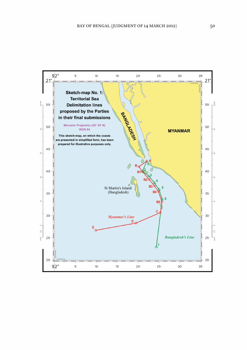
bay of bengal (judgment of 14 march 2012) 50
165. Having examined the Parties’ coasts that are relevant to the construction of the equidistance line for the delimitation of the territorial sea, the Tribunal is of the view that the coordinates identifijied by Bangladesh in its proposed equi-distance line until point 8A, as depicted in paragraph 2.102 of its Reply, ade-quately defijine an equidistance line measured from the low-water line of the respective coasts of the Parties, including St. Martin’s Island, as reproduced on Admiralty Chart 817.
166. For the above mentioned reasons, the Tribunal decides that the equidis-tance line delimiting the territorial sea between the two Parties is defijined by points 1, 2, 3, 4, 5, 6, 7 and 8 with the following coordinates and connected by geodetic lines:
1: 20° 42’ 15.8” N, 92°22’ 07.2” E;2: 20° 40’ 45.0” N, 92°20’ 29.0” E;3: 20° 39’ 51.0” N, 92° 21’ 11.5” E;4: 20° 37’ 13.5” N, 92° 23’ 42.3” E;5: 20° 35’ 26.7” N, 92° 24’ 58.5” E;6: 20° 33’ 17.8” N, 92° 25’ 46.0” E;7: 20° 26’ 11.3” N, 92° 24’ 52.4” E;8: 20° 22’ 46.1” N, 92° 24’ 09.1” E.
167. The delimitation line is shown on the attached sketch-map number 2.
168. The Tribunal observes that, in giving St. Martin’s Island full efffect in the delimitation of the territorial sea, the delimitation line will reach a point where the island’s territorial sea no longer overlaps with the territorial sea of Myanmar. At this point, the territorial sea around St. Martin’s Island begins to meet the exclusive economic zone and the continental shelf of Myanmar. This will occur in the area defijined by the 12 nm envelope of arcs of the territorial sea of St. Martin’s Island beyond point 8.
169. As a consequence, the Tribunal is no longer faced with the task of having to delimit the territorial sea beyond point 8. The Tribunal recognizes that Bangladesh has the right to a 12 nm territorial sea around St. Martin’s Island in the area where such territorial sea no longer overlaps with Myanmar’s territorial sea. A conclusion to the contrary would result in giving more weight to the sov-ereign rights and jurisdiction of Myanmar in its exclusive economic zone and continental shelf than to the sovereignty of Bangladesh over its territorial sea.
bay of bengal (judgment of 14 march 2012) 51

bay of bengal (judgment of 14 march 2012) 52
Sketch-map No. 2:
prepared for illustrative purposes only.
Mercator Projection (20° 20' N)
Tribunal's delimitation
This sketch-map, on which the coastsare presented in simplified form, has been
Territorial Sea
WGS 84
7
MYANMAR
6
5
4
BANGLADESH
1
(Bangladesh)
32
8
St Martin's Island
Right of passage of ships of Myanmar through the territorial sea of Bangladesh
around St. Martin’s Island
170. The question of free and unimpeded navigation by Myanmar in the territo-rial sea of Bangladesh around St. Martin’s Island to and from the Naaf River is not an issue to be considered in respect of delimitation. It is, however, a related matter of particular concern to Myanmar.
171. In this context, the Tribunal requested the Parties to address the following question: “Given the history of discussions between them on the issue, would the Parties clarify their position regarding the right of passage of ships of Myanmar through the territorial sea of Bangladesh around St. Martin’s Island?”
172. Myanmar explained that it considered a guarantee of this right as “crucially important” but that, in Myanmar’s view, Bangladesh had “never given the guar-antee that Myanmar sought”. Myanmar points out that there had been no prob-lems with access to Bangladesh’s territorial sea but mainly because, “in the absence of any guarantee”, Myanmar had never sought to put to test its right. Overall, Myanmar states that the “position on the right of passage of ships of Myanmar through the territorial sea of Bangladesh around St Martin’s Island continues to be less than satisfactory”.
173. On this issue, Bangladesh stated in its Memorial that “[a]s part of, and in consideration for, their November 1974 agreement, Bangladesh also agreed to accord Myanmar’s vessels the right of free and unimpeded navigation through Bangladesh’s waters around St. Martin’s Island to and from the Naaf River”.
174. In response to the request from the Tribunal, the Foreign Minister of Bangladesh, its Agent in the present case, during the hearing stated the following:
Since at least 1974 Bangladesh and Myanmar have engaged in extensive negotiations concerning their maritime boundary in the Bay of Bengal. Over the course of 34 years, our countries have conducted some 13 rounds of talks. We achieved some notable early successes. In particular, in 1974, at just our second round of meetings, we reached the agreement concerning the maritime boundary in the territorial sea, about which you will hear more tomorrow. That agreement was fully applied and respected by both States over more than three decades. As a result of that agreement, there have never been any problems concerning the right of passage of ships of
bay of bengal (judgment of 14 march 2012) 53
Myanmar through our territorial sea around St Martin’s Island. In its two rounds of pleadings Myanmar had every opportunity to introduce evidence of any difffijiculties, if indeed there were any. It has not done so. That is because there are no difffijiculties. I am happy to restate that Bangladesh will continue to respect such access in full respect of its legal obligations.
175. Counsel for Bangladesh thereafter stated: “What the Foreign Minister and Agent says in response to a direct question from an international tribunal com-mits the State”.
176. The Tribunal takes note of this commitment by Bangladesh.
VIII. Exclusive economic zone and continental shelf within 200 nautical miles
177. The Tribunal will now turn to the delimitation of the exclusive economic zone and the continental shelf within 200 nm.
Single delimitation line
178. Before proceeding with the delimitation of the exclusive economic zone and the continental shelf, the Tribunal must clarify the nature of the delimita-tion line.
179. Bangladesh states that the Tribunal should identify a single line to delimit the seabed and subsoil and the superjacent waters. Bangladesh notes that its position is “in accordance with the international judicial practice”. According to Bangladesh, although the Convention contains separate provisions for the delimitation of the exclusive economic zone and the continental shelf, “interna-tional practice has largely converged around the drawing of a ’single maritime boundary’ to delimit both zones”.
180. Myanmar, in turn, states that the Parties agree in asking the Tribunal to draw a single maritime boundary for the superjacent waters, the seabed and subsoil, that is, for the exclusive economic zone and the continental shelf.
181. The Tribunal accordingly will draw a single delimitation line for both the exclusive economic zone and the continental shelf.
bay of bengal (judgment of 14 march 2012) 54

Applicable law
182. The Tribunal points out that the provisions of the Convention applicable to the delimitation of the exclusive economic zone and the continental shelf are in articles 74 and 83. The Tribunal observes that these two articles are identical in their content, difffering only in respect of the designation of the maritime area to which they apply. These articles state as follows:
1. The delimitation of the [exclusive economic zone/continental shelf] between States with opposite or adjacent coasts shall be efffected by agree-ment on the basis of international law, as referred to in article 38 of the Statute of the International Court of Justice, in order to achieve an equitable solution.
2. If no agreement can be reached within a reasonable period of time, the States concerned shall resort to the procedures provided for in Part XV.
3. Pending agreement as provided for in paragraph 1, the States concerned, in a spirit of understanding and cooperation, shall make every efffort to enter into provisional arrangements of a practical nature and, during this transitional period, not to jeopardize or hamper the reaching of the fijinal agreement. Such arrangements shall be without prejudice to the fijinal delimitation.
4. Where there is an agreement in force between the States concerned, questions relating to the delimitation of the [exclusive economic zone/con-tinental shelf] shall be determined in accordance with the provisions of that agreement.
183. Although article 74, paragraph 1, and article 83, paragraph 1, of the Convention explicitly address delimitation agreements, they also apply to judi-cial and arbitral delimitation decisions. These paragraphs state that delimitation must be efffected “on the basis of international law, as referred to in article 38 of the Statute of the International Court of Justice, in order to achieve an equitable solution”. Customary international law is one of the sources identifijied in article 38. Accordingly, the law applicable under the Convention with regard to delim-itation of the exclusive economic zone and the continental shelf includes rules of customary international law. It follows that the application of such rules in the context of articles 74 and 83 of the Convention requires the achievement of an equitable solution, as this is the goal of delimitation prescribed by these articles.
bay of bengal (judgment of 14 march 2012) 55
184. Decisions of international courts and tribunals, referred to in article 38 of the Statute of the ICJ, are also of particular importance in determining the con-tent of the law applicable to maritime delimitation under articles 74 and 83 of the Convention. In this regard, the Tribunal concurs with the statement in the Arbitral Award of 11 April 2006 that: “In a matter that has so signifijicantly evolved over the last 60 years, customary law also has a particular role that, together with judicial and arbitral decisions, helps to shape the considerations that apply to any process of delimitation” (Arbitration between Barbados and the Republic
of Trinidad and Tobago, relating to the delimitation of the exclusive economic zone
and the continental shelf between them, Decision of 11 April 2006, RIAA, Vol. XXVII, p. 147, at pp. 210-211, para. 223).
Relevant coasts
185. The Tribunal will now turn to the delimitation process. In examining this issue, the Tribunal notes “the principle that the land dominates the sea through the projection of the coasts or the coastal fronts” (Maritime Delimitation in the
Black Sea (Romania v. Ukraine), Judgment, I.C.J. Reports 2009, p. 61, at p. 89, para. 77). As stated by the ICJ in the North Sea cases, “the land is the legal source of the power which a State may exercise over territorial extensions to seaward” (North Sea Continental Shelf, Judgment, I.C.J. Reports 1969, p. 3, at p. 51, paragraph 96).
186. Bangladesh is of the view that its entire coast is relevant “from the land boundary terminus with Myanmar in the Naaf River to the land boundary ter-minus with India in the Raimangal Estuary”.
187. Bangladesh measures this coast by means of two straight lines in order to avoid the signifijicant difffijiculties caused by the sinuosities of the coast. According to Bangladesh, the combined length of these lines is 421 kilometres.
188. Myanmar describes the coast of Bangladesh as being made up of four seg-ments. The fijirst segment proceeds in an easterly direction from the land border with India to the mouth of the Meghna River. The fourth segment proceeds in a south-southeasterly direction from the Lighthouse on Kutubdia Island to the land border with Myanmar. Between these two segments lie the second and third segments in the mouth of the Meghna River.
bay of bengal (judgment of 14 march 2012) 56
189. According to Myanmar, Bangladesh’s relevant coast is limited to the fijirst and fourth segments. Myanmar rejects the second and third segments as parts of the relevant coast because those segments “face each other and therefore cannot possibly overlap with Myanmar’s maritime projections”. Myanmar com-pares these segments of Bangladesh’s coast to Ukraine’s coasts in the Gulf of Karkinits’ka in the Black Sea case, in which the ICJ excluded those coasts of Ukraine because they “face each other and their submarine extension cannot overlap with the extensions of Romania’s coasts” (Maritime Delimitation in the
Black Sea (Romania v. Ukraine), Judgment, I.C.J. Reports, 2009, p. 61, at p. 97, para. 100).
190. Measuring the coastal length by taking into account the coastline and its sinuosity, Myanmar fijinds that the fijirst and fourth segments of Bangladesh’s coast are 203 kilometres and 161 kilometres long respectively. In Myanmar’s view, the total length of Bangladesh’s relevant coast is 364 kilometres.
191. Bangladesh submits that the analogy between the mouth of the Meghna River and the Gulf of Karkinits’ka is not accurate. In its view, while, in the enclosed setting of the Black Sea, “the opening at the mouth of the Gulf of Karkinits’ka faces back onto other portions of Ukraine’s coast, and not onto the delimitation [area] [. . .], [h]ere, in contrast, the opening at the mouth of the Meghna faces directly onto the open sea and the delimitation [area]”. According to Bangladesh, the opening at the mouth of the Meghna River is much more like the opening at the mouth of the Bay of Fundy in the case concerning Delimitation
of the Maritime Boundary in the Gulf of Maine, in which the Chamber of the ICJ deemed relevant “segments of Canada’s parallel coasts within the Bay as well as the line drawn across the Bay inside its mouth”.
192. According to Bangladesh, Myanmar’s relevant coast extends from the land boundary terminus in the Naaf River to the area of Bhifff Cape. Bangladesh regards Myanmar’s coast south of Bhifff Cape as irrelevant, because, in its view, the projection of that coast, which is more than 200 nm from Bangladesh, could not overlap with that of Bangladesh’s coast.
193. Bangladesh therefore maintains that Myanmar’s relevant coastal length, measured by means of a straight line, is 370 kilometres.
bay of bengal (judgment of 14 march 2012) 57
194. Myanmar asserts that its own relevant coast extends from the land bound-ary terminus between Myanmar and Bangladesh up to Cape Negrais. In particu-lar, Myanmar emphasizes that its “relevant coast does not stop near Bhifff Cape”, but comprises the entire Rakhine (Arakan) coast, “from the Naaf River to Cape Negrais, the last point on Myanmar’s coast generating maritime projections overlapping with Bangladesh’s coastal projections”.
195. According to Myanmar, the arguments of Bangladesh to exclude the coast below Bhifff Cape “are quite simply wrong. It is not the relevant area that deter-mines the relevant coast, it is the relevant coast that circumscribes the area to be delimited”. Myanmar asserts further that:
the relevant coasts cannot depend, or be determined by reference to the delimitation line. They logically precede it, and it is the delimitation line that must be determined by reference to the relevant coasts and the projec-tions that these generate. Bangladesh has put the cart before the horse.
196. Myanmar also points out that Bangladesh, according to its own minutes, acknowledged during the negotiations between the Parties in November 2008 that “the relevant coastline for Myanmar in the Bay of Bengal is up to Cape Negrais”.
197. In Myanmar’s view, taking into account the coastline and its sinuosity, the total length of its own relevant coast from the estuary of the Naaf River to Cape Negrais is 740 kilometres.
* * *198. The Tribunal notes at the outset that for a coast to be considered as rele-vant in maritime delimitation it must generate projections which overlap with those of the coast of another party.
199. The Parties are not in agreement in respect of the segments of Bangladesh’s coastline formed by the eastern and western shores of the Meghna River Estuary. They also disagree in respect of the segment of Myanmar’s coast that runs from Bhifff Cape to Cape Negrais.
Bangladesh’s relevant coast
200. The Tribunal does not agree with Myanmar’s position that the eastern and western shores of the Meghna River Estuary should not be treated as part of the relevant coast. In the present case, the situation is diffferent from that of the Gulf
bay of bengal (judgment of 14 march 2012) 58

of Karkinits’ka, where the coastal segments face each other. The Meghna River Estuary is open to the sea and generates projections that overlap with those of the coast of Myanmar. Accordingly, the shores of the estuary must be taken into account in calculating the length of the relevant coast of Bangladesh.
201. The Tribunal concludes that the whole of the coast of Bangladesh is rele-vant for delimitation purposes, generating projections seaward that overlap with projections from the coast of Myanmar. To avoid difffijiculties caused by the complexity and sinuosity of that coast, it should be measured in two straight lines.
202. The Tribunal draws the fijirst line from a point on Bangladesh’s coast on Mandabaria Island near the land boundary terminus with India, which was used by Myanmar as a base point (ß2) for the construction of its proposed equidis-tance line (see paragraph 243), to a point on Kutubdia Island (see paragraph 188). The second line extends from the said point on Kutubdia Island to the land boundary terminus with Myanmar in the Naaf River. As a result, the length of Bangladesh’s relevant coast is approximately 413 kilometres.
Myanmar’s relevant coast
203. The Tribunal does not agree with Bangladesh’s position that Myanmar’s coastline south of Bhifff Cape should not be included in the calculation of Myanmar’s relevant coast. The Tribunal fijinds that the coast of Myanmar from the terminus of its land boundary with Bangladesh to Cape Negrais does, con-trary to Bangladesh’s contention, indeed generate projections that overlap pro-jections from Bangladesh’s coast. The Tribunal, therefore, determines that the coast of Myanmar from its land boundary terminus with Bangladesh to Cape Negrais is to be regarded as Myanmar’s relevant coast.
204. The Tribunal fijinds that Myanmar’s relevant coast should also be measured by two lines so as to avoid difffijiculties caused by the sinuosity of the coast and to ensure consistency in measuring the respective coasts of the Parties. The fijirst line is measured from the land boundary terminus in the Naaf River to Bhifff Cape and the second line from this point to Cape Negrais. Accordingly, the Tribunal concludes that the length of the relevant coast of Myanmar, measured in two lines, is approximately 587 kilometres.
205. Having determined the relevant coasts of the Parties and their approxi-mate length, the Tribunal fijinds that the ratio between these coastal lengths is approximately 1:1.42 in favour of Myanmar.
bay of bengal (judgment of 14 march 2012) 59

bay of bengal (judgment of 14 march 2012) 60
Method of delimitation
206. The Tribunal will now consider the method to be applied to the delimita-tion of the exclusive economic zone and the continental shelf in the case before it.
207. While the Parties agree that the provisions of the Convention concerning the delimitation of the exclusive economic zone and the continental shelf con-stitute the law applicable to the dispute between them, they disagree as to the appropriate method of delimitation.
208. Bangladesh recognizes that the equidistance method is used in appropri-ate circumstances as a means to achieve an equitable solution but claims that equidistance does not produce an equitable result in the present case.
209. Bangladesh challenges the validity of the equidistance method advocated by Myanmar for the delimitation of the exclusive economic zone and the conti-nental shelf within 200 nm. It argues that the equidistance line is inequitable in the present case, adding that Myanmar so completely embraces the equidis-tance method as to go so far as to claim that “rights to maritime areas are gov-erned by equidistance” and to elevate equidistance, merely one method of delimitation, into a rule of law of universal application.
210. Bangladesh observes that the use of the equidistance method “can under certain circumstances produce results that appear on the face of them to be extraordinary, unnatural or unreasonable” as stated in the North Sea Continental
Shelf cases ( Judgment, I.C.J. Reports 1969, p. 3, at p. 23, para. 24).
211. Bangladesh points out that concave coasts like those in the northern Bay of Bengal are among the earliest recognized situations where equidistance pro-duces “irrational results” and refers in this regard to the case concerning Continental Shelf (Libyan Arab Jamahiriya/Malta), in which the ICJ stated that an equidistance line “may yield a disproportionate result where a coast is mark-edly irregular or markedly concave or convex” ( Judgment, I.C.J. Reports 1985, p. 13, at p. 44, para. 56). In the same case the ICJ pointed out that equidistance is “not the only method applicable [. . .]” and it does “not even have the benefijit of a presumption in its favour” (ibid., p. 13, at p. 47, para. 63).
bay of bengal (judgment of 14 march 2012) 61

212. Bangladesh also points to the case concerning Territorial and Maritime
Dispute between Nicaragua and Honduras in the Caribbean Sea (Nicaragua v. Honduras), in which the ICJ stated that the equidistance method “does not auto-matically have priority over other methods of delimitation and, in particular circumstances, there may be factors which make the application of the equidis-tance method inappropriate” ( Judgment, I.C.J. Reports 2007, p. 659, at p. 741, para. 272).
213. Bangladesh argues that, on account of the specifijic confijiguration of its coast in the northern part of the Bay of Bengal and of the double concavity character-izing it, the Tribunal should apply the angle-bisector method in delimiting the maritime boundary between Bangladesh and Myanmar in the exclusive eco-nomic zone and on the continental shelf. In its view, this method would elimi-nate the inequity associated with equidistance and lead to an equitable result.
214. Bangladesh further states that the ICJ fijirst made use of the angle-bisector method in the case concerning Continental Shelf (Tunisia/Libyan Arab Jamahiriya) in 1982 and that the 1984 decision of the Chamber of the ICJ in the case concern-ing Delimitation of the Maritime Boundary in the Gulf of Maine Area is another instance of resort to that method. Likewise, the Arbitral Tribunal in the case concerning the Delimitation of the maritime boundary between Guinea and
Guinea-Bissau (Decision of 14 February 1985, ILR, Vol. 77, p. 635) applied the angle-bisector method in delimiting the maritime boundaries at issue.
215. Bangladesh also quotes the case concerning the Territorial and Maritime
Dispute between Nicaragua and Honduras in the Caribbean Sea (Nicaragua v. Honduras) in support of its argument that the use of a bisector “has proved to be a viable substitute method in certain circumstances where equidistance is not possible or appropriate” ( Judgment, I.C.J. Reports 2007, p. 659, at p. 746, para. 287).
216. Bangladesh states that Myanmar’s claimed equidistance line is inequitable because of the cut-offf efffect it produces. Bangladesh maintains that, “[n]otwith-standing Bangladesh’s substantial 421 km coastline, the equidistance lines claimed by its neighbours would prevent it from reaching even its 200 [nm] limit, much less its natural prolongation in the outer continental shelf beyond 200 [nm]”.
bay of bengal (judgment of 14 march 2012) 62
217. Bangladesh argues that the angle-bisector method, specifijically the 215° azi-muth line which it advocates for the delimitation of the maritime boundary between Myanmar and itself on the continental shelf within 200 nm and in the exclusive economic zone, “avoids the problems inherent in equidistance with-out itself generating any inequities”.
218. In Myanmar’s view, the law of delimitation “has been considerably com-pleted, developed and made more specifijic” since the adoption of the Convention in 1982. Myanmar contends that Bangladesh attempts to cast doubt on the now well-established principles of delimitation of the exclusive economic zone and the continental shelf. Myanmar further contends that Bangladesh makes strenu-ous effforts to establish that the applicable law was frozen in 1982 or, even better, in 1969, thus deliberately ignoring the developments which have occurred over the past 40 years.
219. Myanmar states that “ ‘equidistance/relevant circumstances’ is not as such a rule of delimitation properly said, but a method, usually producing an equi-table result”. Myanmar draws attention in this regard to the ICJ’s judgment in the case concerning Territorial and Maritime Dispute between Nicaragua and
Honduras in the Caribbean Sea (Nicaragua v. Honduras) ( Judgment, I.C.J. Reports
2007, p. 659, at p. 741, para. 271).
220. Myanmar points out that, while Bangladesh relied on the judgment in the case concerning Territorial and Maritime Dispute between Nicaragua and
Honduras in the Caribbean Sea (Nicaragua v. Honduras), where the ICJ held that “the equidistance method does not automatically have priority over other meth-ods of delimitation”, it failed to mention that the ICJ said in the same case: “[t]he jurisprudence of the Court sets out the reasons why the equidistance method is widely used in the practice of maritime delimitation: it has a certain intrinsic value because of its scientifijic character and the relative ease with which it can be applied”. ( Judgment, I.C.J. Reports 2007, p. 659, at p. 741, para. 272). Myanmar adds that the ICJ in that same case applied the bisector method only after fijinding it “impossible for the Court to identify base points and construct a provisional equidistance line [. . .] delimiting maritime areas offf the Parties’ mainland coasts” (Ibid., p. 659, at p. 743, para. 280).
221. Myanmar further observes that in the case concerning Continental Shelf
(Libyan Arab Jamahiriya/Malta) the ICJ applied the equidistance/relevant cir-cumstances method even after noting that equidistance “may yield a dispropor-
bay of bengal (judgment of 14 march 2012) 63

tionate result where a coast is markedly irregular or markedly concave or convex” ( Judgment, I.C.J Reports 1985, p. 13, at p. 44, para. 56).
222. Myanmar requests the Tribunal to “apply the now well-established method for drawing an all-purpose line for the delimitation of the maritime boundary between the Parties”. Myanmar asserts that “[i]n the present case, no circum-stance renders unfeasible the use of the equidistance method”. In support of this request, it refers to the Black Sea case (Maritime Delimitation in the Black Sea
(Romania v. Ukraine), Judgment, I.C.J. Reports 2009, p. 61, at p. 101, para. 116).
223. Myanmar rejects the arguments advanced by Bangladesh that the equidis-tance line fails to take account of the relevant circumstances in the case, notably the cut-offf efffect it produces and the concavity of Bangladesh’s coast, and states that “[n]one of the reasons invoked by Bangladesh to set aside the usual method of drawing the maritime boundary between States has any basis in modern international law of the sea, the fijirst step of which is to identify the provisional equidistance line”.
224. In Myanmar’s view, the angle-bisector method advanced by Bangladesh produces an inequitable result and Myanmar “fijirmly . . . reiterate[s] that no rea-son whatsoever justifijies recourse to the ‘angle-bisector method’ in the present case”.
* * *225. The Tribunal observes that article 74, paragraph 1, and article 83, para-graph 1, of the Convention stipulate that the delimitation of the exclusive eco-nomic zone and the continental shelf respectively must be efffected on the basis of international law in order to achieve an equitable solution, without specifying the method to be applied.
226. International courts and tribunals have developed a body of case law on maritime delimitation which has reduced the elements of subjectivity and uncertainty in the determination of maritime boundaries and in the choice of methods employed to that end.
227. Beginning with the North Sea Continental Shelf cases, it was emphasized in the early cases that no method of delimitation is mandatory, and that the con-fijiguration of the coasts of the parties in relation to each other may render an equidistance line inequitable in certain situations. This position was fijirst articu-lated with respect to the continental shelf, and was thereafter maintained with respect to the exclusive economic zone as well.
bay of bengal (judgment of 14 march 2012) 64

228. Over time, the absence of a settled method of delimitation prompted increased interest in enhancing the objectivity and predictability of the process. The varied geographic situations addressed in the early cases nevertheless con-fijirmed that, even if the pendulum had swung too far away from the objective precision of equidistance, the use of equidistance alone could not ensure an equitable solution in each and every case. A method of delimitation suitable for general use would need to combine its constraints on subjectivity with the flex-ibility necessary to accommodate circumstances in a particular case that are relevant to maritime delimitation.
229. In the case concerning Maritime Delimitation in the Area between Greenland
and Jan Mayen, the ICJ expressly articulated the approach of dividing the delim-itation process into two stages, namely “to begin with the median line as a pro-visional line and then to ask whether ‘special circumstances’ require any adjustment or shifting of that line” ( Judgment, I.C.J. Reports 1993, p. 38, at p. 61, para. 51). This general approach has proven to be suitable for use in most of the subsequent judicial and arbitral delimitations. As developed in those cases, it has come to be known as the equidistance/relevant circumstances method.
230. In the case concerning Maritime Delimitation and Territorial Questions
between Qatar and Bahrain, the ICJ adopted the same approach (Merits, Judgment,
I.C.J. Reports 2001, p. 40, at p. 111, para. 230). In 2002, in the case concerning the Land and Maritime Boundary between Cameroon and Nigeria (Cameroon v. Nigeria: Equatorial Guinea intervening), the ICJ confijirmed its previous two-stage approach to the delimitation ( Judgment, I.C.J. Reports 2002, p. 303, at p. 441, para. 288).
231. The Arbitral Tribunal in the Arbitration between Barbados and the Republic
of Trinidad and Tobago, afffijirmed that “[t]he determination of the line of delim-itation [. . .] normally follows a two-step approach”, involving the positing of a provisional line of equidistance and then examining it in the light of the rele-vant circumstances. The Arbitral Tribunal further pointed out that “while no method of delimitation can be considered of and by itself compulsory, and no court or tribunal has so held, the need to avoid subjective determinations requires that the method used start with a measure of certainty that equidis-tance positively ensures, subject to its subsequent correction if justifijied” (Decision
of 11 April 2006, RIAA, Vol. XXVII, p. 147, at p.214, para. 242, and at p. 230, para. 306).
232. Similarly, the Arbitral Tribunal in the case between Guyana and Suriname noted:
bay of bengal (judgment of 14 march 2012) 65

The case law of the International Court of Justice and arbitral jurisprudence as well as State practice are at one in holding that the delimitation process should, in appropriate cases, begin by positing a provisional equidistance line which may be adjusted in the light of relevant circumstances in order to achieve an equitable solution (Arbitration between Guyana and Suriname, Award of 17 September 2007, ILM, Vol. 47 (2008), p. 116, at p. 213, para. 342).
233. In the Black Sea case, the ICJ built on the evolution of the jurisprudence on maritime delimitation. In that case, the ICJ gave a description of the three-stage methodology which it applied. At the fijirst stage, it established a provisional equidistance line, using methods that are geometrically objective and also appropriate for the geography of the area to be delimited. “So far as delimitation between adjacent coasts is concerned, an equidistance line will be drawn unless there are compelling reasons that make this unfeasible in the particular case” (Maritime Delimitation in the Black Sea (Romania v. Ukraine), Judgment, I.C.J.
Reports 2009, p. 61, at p. 101, para. 116). At the second stage, the ICJ ascertained whether “there are factors calling for the adjustment or shifting of the provi-sional equidistance line in order to achieve an equitable result” (ibid., at pp. 101, para. 120). At the third stage, it verifijied that the delimitation line did not lead to “an inequitable result by reason of any marked disproportion between the ratio of the respective coastal lengths and the ratio between the relevant maritime area of each State by reference to the delimitation line” (ibid., at p. 103, para. 122).
234. The Tribunal notes that, as an alternative to the equidistance/relevant cir-cumstances method, where recourse to it has not been possible or appropriate, international courts and tribunals have applied the angle-bisector method, which is in efffect an approximation of the equidistance method. The angle-bisector method was applied in cases preceding the Libyan Arab Jamahiriya/
Malta judgment, namely, Continental Shelf (Tunisia/Libyan Arab Jamahiriya) ( Judgment, I.C.J. Reports 1982, p. 18, at p. 94, para. 133 (C) (3)), Delimitation of the
Maritime Boundary in the Gulf of Maine Area ( Judgment, I.C.J. Reports 1984, p. 246, at p. 333, para. 213), and Delimitation of the Maritime Boundary between
Guinea and Guinea-Bissau (Decision of 14 February 1985, ILR, Vol. 77, p. 635, at pp. 683-685, paras. 108-111). It was more recently applied in the case concerning Territorial and Maritime Dispute between Nicaragua and Honduras in the
Caribbean Sea (Nicaragua v. Honduras) ( Judgment, I.C.J. Reports 2007, p. 659, at p. 741, para. 272 and at p. 746, para. 287).
bay of bengal (judgment of 14 march 2012) 66
235. The Tribunal observes that the issue of which method should be followed in drawing the maritime delimitation line should be considered in light of the circumstances of each case. The goal of achieving an equitable result must be the paramount consideration guiding the action of the Tribunal in this connec-tion. Therefore the method to be followed should be one that, under the prevail-ing geographic realities and the particular circumstances of each case, can lead to an equitable result.
236. When the angle bisector method is applied, the terminus of the land boundary and the generalization of the direction of the respective coasts of the Parties from that terminus determine the angle and therefore the direction of the bisector. Diffferent hypotheses as to the general direction of the respective coasts of the Parties from the terminus of the land boundary will often produce diffferent angles and bisectors.
237. Bangladesh’s approach of constructing the angle at the terminus of the land boundary between the Parties with reference to the ends of their respective relevant coasts produces a markedly diffferent bisector once it is recognized that Myanmar’s relevant coast extends to Cape Negrais, as decided by the Tribunal in paragraph 203. The resultant bisector fails to give adequate efffect to the south-ward projection of the coast of Bangladesh.
238. The Tribunal notes that jurisprudence has developed in favour of the equi-distance/relevant circumstances method. This is the method adopted by inter-national courts and tribunals in the majority of the delimitation cases that have come before them.
239. The Tribunal fijinds that in the present case the appropriate method to be applied for delimiting the exclusive economic zone and the continental shelf between Bangladesh and Myanmar is the equidistance/relevant circumstances method.
240. In applying this method to the drawing of the delimitation line in the pres-ent case, the Tribunal, taking into account the jurisprudence of international courts and tribunals on this matter, will follow the three stage-approach, as developed in the most recent case law on the subject. Accordingly, the Tribunal will proceed in the following stages: at the fijirst stage it will construct a provi-sional equidistance line, based on the geography of the Parties’ coasts and math-ematical calculations. Once the provisional equidistance line has been drawn, it will proceed to the second stage of the process, which consists of determining whether there are any relevant circumstances requiring adjustment of the pro-visional equidistance line; if so, it will make an adjustment that produces an
bay of bengal (judgment of 14 march 2012) 67
equitable result. At the third and fijinal stage in this process the Tribunal will check whether the line, as adjusted, results in any signifijicant disproportion between the ratio of the respective coastal lengths and the ratio of the relevant maritime areas allocated to each Party.
Establishment of the provisional equidistance line
Selection of base points
241. The Tribunal will now proceed with the construction of its own provisional equidistance line. The fijirst step to be taken in this regard is to select the base points for the construction of that line.
242. Bangladesh did not identify any base points, because it did not construct a provisional equidistance line and therefore saw no need to select base points on the Bangladesh or Myanmar coasts.
243. Myanmar identifijied two relevant base points on the coast of Bangladesh “representing the most advanced part of the land (low water line) into the sea”. These two base points are:
(β1) the closest point to the starting-point of the maritime boundary (Point A) located on the low water line of Bangladesh’s coast, base point β1 (co-ordinates 20°43’28.1” N, 92°19’40.1” E) [. . .]; and
(β2) the more stable point located on Bangladesh coast nearest to the land boundary with India, base point β2 (co-ordinates 21° 38’ 57.4” N, 89° 14’ 47.6” E).
244. Myanmar points out that base point β2 is, according to Bangladesh, located on a coast characterized by a very active morpho-dynamism. Myanmar notes that Bangladesh “expresses concern that ‘the location of base point β2 this year might be very diffferent from its location next year’ ”. Myanmar adds that “it is difffijicult to detect any change in the location of β2 in the sixteen years from 1973 to 1989”. Myanmar observes that satellite images show that the β2 area is quite stable.
245. Myanmar identifijies three base points on its own coast and describes them as follows:
bay of bengal (judgment of 14 march 2012) 68
(μ1) at the mouth of the Naaf River, the closest point of the starting-point of the maritime boundary (Point A) located on the low water line of Myanmar’s coast, base point μ1 (co-ordinates 20° 41’ 28.2” N, 92° 22’ 47.8” E) [. . .]
(μ2) Kyaukpandu (Satoparokia) Point, located on the landward/low water line most seaward near Kyaukpandu Village, base point μ2 (co-ordinates 20° 33’ 02.5” N, 92° 31’ 17.6” E) [. . .].
(μ3) at the mouth of the May Yu River (close to May Yu Point), base point μ3 (co-ordinates 20° 14’ 31.0” N, 92° 43’ 27.8” E) [. . .].
246. Myanmar asserts that any base points on Bangladesh’s mainland coast and coastal islands could be considered legally appropriate base points, but because β1 is nearer to the provisional equidistance line, the other potential base points are not relevant. Myanmar notes that on its own side the same is true of base points on the coastal features south of base point µ3. These potential base points on the coasts were eliminated on the basis of the objective criterion of distance.
247. Myanmar states that several other base points were eliminated for legal reasons. With reference to South Talpatty, Myanmar explains that it could have been:
a potential source of relevant base points because of its relatively seaward location. Yet, as a legal matter, South Talpatty cannot be a source of base points for two reasons. First, the sovereignty of this feature is disputed between Bangladesh and India. Second, [. . .] it is not clear whether the coastal feature – which may have existed in 1973 – still exists.
248. According to Myanmar, there is a second example of a set of coastal fea-tures that are potential sources of relevant base points but were nonetheless excluded from the calculation of the equidistance line. These are “the low-tide elevations around the mouth of the Naaf River, the Cypress Sands, and Sitaparokia Patches, offf Myanmar’s coast”.
249. Myanmar points out that “[n]either Party used base points on those low-tide elevations”, despite the fact that they are legitimate sources of base points for measuring the breadth of the territorial sea and are nearer to the territorial sea equidistance line than the base points on the mainland coasts. Myanmar
bay of bengal (judgment of 14 march 2012) 69
explains that these low-tide elevations are also nearer the provisional equidis-tance line than either base point β1 or µ1. Myanmar states that “they cannot be used, as a legal matter,” for the purpose of constructing the provisional equidis-tance line.
250. Myanmar submits that Myanmar’s May Yu Island and Bangladesh’s St. Martin’s Island “must be eliminated as sources of base points”. Myanmar acknowledges that both features are legitimate sources of normal baselines for measuring the breadth of the territorial sea, and both would otherwise have provided the nearest base points, that is, the relevant base points, for the con-struction of the provisional equidistance line. Myanmar, however, concludes that “the technical qualities of these features cannot overcome their legal defiji-ciencies”.
251. In the view of Myanmar, “the use of these anomalous features in the con-struction of the provisional equidistance line would create a line that would be [. . .] ‘wholly inconsistent with the dominant geographic realities in the area’ ”. Myanmar states that Bangladesh is correct in arguing that, if these islands were used in the construction of the provisional equidistance line, the entire course of that line would be determined by these two features alone.
252. Bangladesh maintains that:
Myanmar’s proposed equidistance line is also problematic because it is drawn on the basis of just four coastal base points, three on Myanmar’s coast and only one – base point β1 – on the Bangladesh coast, which Myanmar places very near the land boundary terminus between Bangladesh and Myanmar in the Naaf River.
253. According to Bangladesh, Myanmar “takes pains to make it appear as though it actually uses two Bangladesh base points in the plotting of the equi-distance line”. Bangladesh contends that Myanmar does not “show the efffect of alleged base point β2 on its proposed delimitation line, because it has none”. Bangladesh observes that “[b]ase point β2 never actually comes into play in Myanmar’s proposed delimitation”.
254. Bangladesh asserts that it would be remarkable to base a delimitation on a single coastal base point and that, after a review of the jurisprudence and State practice, Bangladesh was unable to fijind even one example where a delimitation extending so far from the coast was based on just one base point. Bangladesh
bay of bengal (judgment of 14 march 2012) 70
concludes by noting that, “in the Nicaragua v. Honduras case, the ICJ drew a bisector precisely to avoid such a situation”.
255. In the view of Bangladesh, the lack of potential base points on the Bangladesh coast is a function of the concavity of that coast and that after base point β1, the coast recedes into the mouth of the Meghna estuary. It adds that there is thus nothing to counteract the efffect of Myanmar’s coast south of the land boundary terminus and that the concavity of Bangladesh’s coast results in there being no protuberant coastal base points.
256. Bangladesh points out that the consequence can be seen in the efffect of Myanmar’s equidistance line as it moves further and further from shore, becoming, as a result, increasingly prejudicial to Bangladesh, and increasingly inequitable.
257. Bangladesh contends that “[t]here is no legal basis for an a priori assump-tion that St. Martin’s Island should be ignored in the drawing of Myanmar’s equidistance line”. Bangladesh notes that St. Martin’s island “is a signifijicant coastal feature that indisputably generates entitlement in the continental shelf and EEZ”. Bangladesh therefore concludes that “[t]here are thus no grounds, other than Myanmar’s self-interest, for excluding it in the plotting of a provi-sional equidistance line, where, in the fijirst instance, all coastal features are included”.
258. Myanmar responds that fijive base points were sufffijicient in the Black Sea
case to delimit a boundary stretching well over 100 nm from start to fijinish. It states that in other delimitations, especially those between adjacent coasts, even fewer base points have been used: three base points were used for the 170 nm western section of the boundary in the Delimitation of the Continental Shelf
between United Kingdom of Great Britain and Northern Ireland, and the French
Republic (Decision of 30 June 1977, RIAA, Vol. XVIII, p. 3, Annex, Technical Report to the Court, p. 126, at pp. 128-129), and just two base points were used to con-struct the provisional equidistance line in the case concerning the Land and
Maritime Boundary between Cameroon and Nigeria (Cameroon v. Nigeria:
Equatorial Guinea intervening) (Merits, Judgment, I.C.J. Reports 2002, p. 303, at p. 443, para. 292).
bay of bengal (judgment of 14 march 2012) 71
* * *259. The Tribunal will fijirst select the base points to be used for constructing the provisional equidistance line.
260. As noted in paragraph 242, Bangladesh did not identify any base points for the construction of a provisional equidistance line.
261. The Tribunal notes Bangladesh’s contentions that Myanmar does not show the efffect on its proposed delimitation line of base point β2, located on the southern tip of Mandabaria Island, near the land boundary between Bangladesh and India, because that point has none, and that base point β2 never actually comes into play in Myanmar’s proposed delimitation.
262. The Tribunal further notes that the observation made by Bangladesh con-cerning Myanmar’s β2 base point does not amount to a disagreement with the selection of that point; rather, it is a criticism by Bangladesh that Myanmar does not use that base point in its construction of the equidistance line.
263. The Tribunal notes that, while Bangladesh argues that the number of base points selected by Myanmar is insufffijicient for the construction of an equidis-tance line, Bangladesh does not question the fijive base points selected by Myanmar.
264. The Tribunal observes that, while coastal States are entitled to determine their base points for the purpose of delimitation, the Tribunal is not obliged, when called upon to delimit the maritime boundary between the parties to a dispute, to accept base points indicated by either or both of them. The Tribunal may establish its own base points, on the basis of the geographical facts of the case. As the ICJ stated in the Black Sea case:
[i]n [. . .] the delimitation of the maritime areas involving two or more States, the Court should not base itself solely on the choice of base points made by one of those Parties. The Court must, when delimiting the conti-nental shelf and the exclusive economic zones, select base points by refer-ence to the physical geography of the relevant coasts (Maritime Delimitation
bay of bengal (judgment of 14 march 2012) 72
in the Black Sea (Romania v. Ukraine), Judgment, I.C.J. Reports 2009, p. 61, at p. 108, para. 137).
265. Concerning the question whether St. Martin’s Island could serve as the source of a base point, the Tribunal is of the view that, because it is located immediately in front of the mainland on Myanmar’s side of the Parties’ land boundary terminus in the Naaf River, the selection of a base point on St. Martin’s Island would result in a line that blocks the seaward projection from Myanmar’s coast. In the view of the Tribunal, this would result in an unwarranted distortion of the delimitation line, and amount to “a judicial refashioning of geography” (ibid., at p. 110, para. 149). For this reason, the Tribunal excludes St. Martin’s Island as the source of any base point.
266. The Tribunal is satisfijied that the fijive base points selected by Myanmar are the appropriate base points on the coasts of the Parties for constructing the provisional equidistance line. In addition, the Tribunal selects a new base point μ4, which is appropriate for the last segment of the provisional equidistance line. This base point is identifijied on the basis of the Admiralty Chart 817 and is situated on the southern tip of the island of Myay Ngu Kyun, at Boronga Point. Its coordinates are: 19° 48’ 49.8” N, 93° 01’ 33.6” E. The Tribunal will start the construction of a provisional equidistance line by using the following base points:
On the coast of Myanmar: µ1: 20° 41’ 28.2” N, 92° 22’ 47.8” E; µ2: 20° 33’ 02.5” N, 92° 31’ 17.6” E; µ3: 20° 14’ 31.0” N, 92° 43’ 27.8” E; and μ4: 19° 48’ 49.8” N, 93° 01’ 33.6” E.
On the coast of Bangladesh: β1: 20° 43’ 28.1” N, 92° 19’ 40.1” E; and β2: 21° 38’ 57.4” N, 89° 14’ 47.6” E.
Construction of the provisional equidistance line
267. In its written pleadings, Myanmar draws the provisional equidistance line as follows:
bay of bengal (judgment of 14 march 2012) 73
– from Point E (the point at which the equidistance line meets the 12-[nm] arc from the coastline of St. Martin’s Island) with co-ordinates 20° 26’ 42.4” N, 92° 09’ 53.6” E, it continues (following a geodetic azimuth of 214° 08’ 17.5”) until it reaches Point F with co-ordinates 20° 13’ 06.3” N, 92° 00’ 07.6” E, where it becomes afffected by the base points β1, µ1 and µ2;
– from Point F the equidistance line continues in a south-westerly direc-tion (geodetic azimuth 223° 28’ 03.5”) to Point G, with co-ordinates 19° 45’ 36.7” N, 91° 32’ 38.1” E, where the line becomes afffected by the base point µ3;
– from Point G, the equidistance line continues in direction of Point Z, with co-ordinates 18° 31’ 12.5” N, 89° 53’ 44.9” E, which is controlled by base points µ3, β2, and β1.
268. Myanmar’s fijinal submissions describe the last segment of its proposed delimitation as follows:
From Point G, the boundary line continues along the equidistance line in a south-west direction following a geodetic azimuth of 231° 37’ 50.9” until it reaches the area where the rights of a third State may be afffected.
269. Bangladesh argues that this suggests that Myanmar’s “proposed delimita-tion continues along a 232° line throughout its course, no matter where the rights of a third State may be determined to come into play, but that is not an accurate description of the line Myanmar purports to be drawing”.
270. Bangladesh asserts that Myanmar’s proposed Point Z coincides almost exactly with the location at which Myanmar’s proposed equidistance line inter-sects with India’s most recent claim line.
bay of bengal (judgment of 14 march 2012) 74
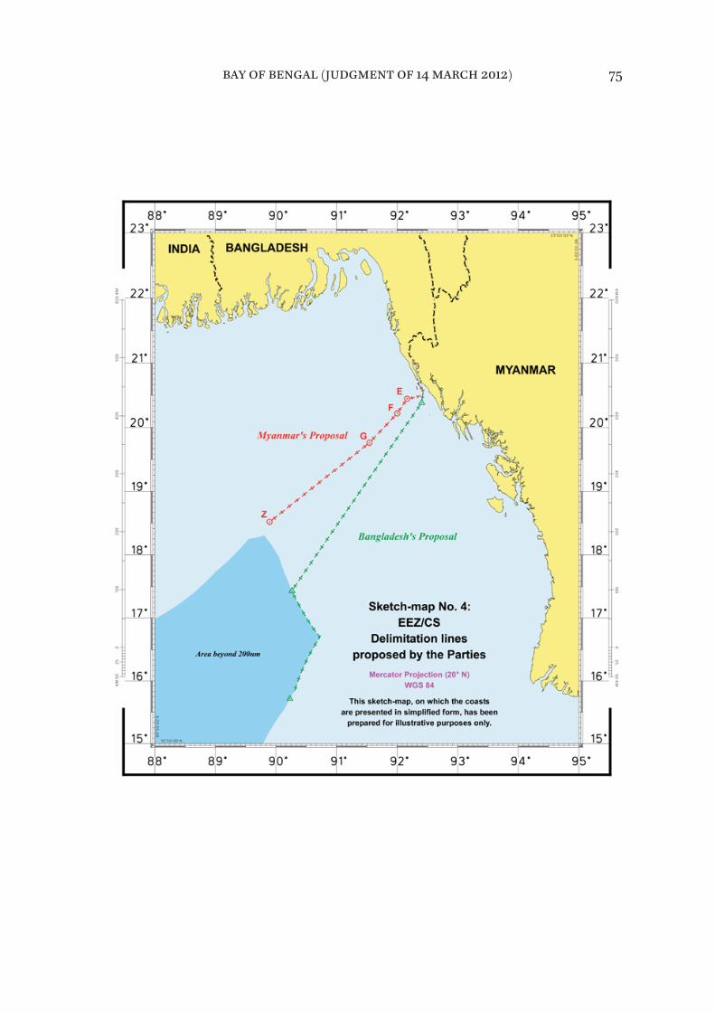
bay of bengal (judgment of 14 march 2012) 75

* * *271. The Tribunal will now construct its provisional equidistance line from base points situated on the coasts of the Parties. For this purpose, it will employ the base points it identifijied in paragraph 266.
272. The provisional equidistance line starts at a point in the Naaf River lying midway between the closest base points on the coasts of the Parties, namely point ß1 on the Bangladesh coast and point µ1 on the Myanmar coast. The coor-dinates of the starting point are 20° 42’ 28.2” N, 92° 21’ 14.0” E.
273. The provisional equidistance line within 200 nm from the baselines from which the territorial seas of the Parties are measured is defijined by the following turning points at which the direction of the line changes and which are con-nected by geodetic lines:
– point T1 which is controlled by base points β1, µ1 and µ2 and which has the coordinates 20° 13’ 06.3’’ N, 92° 00’ 07.6’’ E;
– point T2 which is controlled by base points β1, µ2 and µ3 and which has the coordinates 19° 45’ 36.7’’ N, 91° 32’ 38.1’’ E; and
– point T3 which is controlled by base points β1, β2 and µ3 and which has the coordinates 18° 31’ 12.5’’ N, 89° 53’ 44.9’’ E.
274. From turning point T3, the course of the provisional equidistance line within 200 nm from the baselines of the Parties from which their territorial seas are measured comes under the influence of the additional new base point μ4, as identifijied by the Tribunal. From turning point T3, the provisional equidistance line follows a geodetic line starting at an azimuth of 202° 56’ 22” until it reaches the limit of 200 nm.
bay of bengal (judgment of 14 march 2012) 76
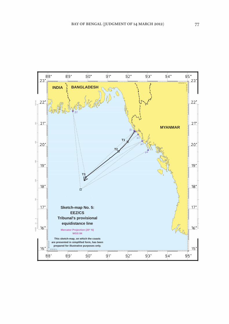
bay of bengal (judgment of 14 march 2012) 77
WGS 84
equidistance lineTribunal's provisional
Sketch-map No. 5:EEZ/CS
T3
MYANMAR
are presented in simplified form, has beenThis sketch-map, on which the coasts
Mercator Projection (20° N)
prepared for illustrative purposes only.
T2
INDIA BANGLADESH
T1

Relevant circumstances
275. Having drawn the provisional equidistance line, the Tribunal will now con-sider whether there are factors in the present case that may be considered rel-evant circumstances, calling for an adjustment of that line with a view to achieving an equitable solution. The Tribunal notes in this regard that the Parties difffer on the issue of relevant circumstances.
276. Bangladesh points out three main geographical and geological features that characterize the present case and are relevant to the delimitation in ques-tion. The fijirst of these is the “concave shape of Bangladesh’s coastline”, extend-ing from the land boundary terminus with India in the west to the land boundary terminus with Myanmar in the east. The Bangladesh coast is further marked by “a second concavity, that is a concavity within the overall concavity of its coastline”. The second major geographical feature is St. Martin’s Island, a signifijicant coastal island lying within 5 nm of the Bangladesh mainland. The third major distinguishing feature is the Bengal depositional system, which com-prises “both the landmass of Bangladesh and its uninterrupted geological pro-longation into and throughout the Bay of Bengal”.
277. Bangladesh maintains that “it is not possible to delimit the boundary in a manner that achieves an equitable solution without taking each of these three features duly into account”. In Bangladesh’s view, these features should be taken into account “as a relevant circumstance in fashioning an equitable delimitation within 200 miles, and should inform the delimitation of the outer continental shelf as between Bangladesh and Myanmar beyond 200 miles”.
278. For its part, Myanmar contends that “there does not exist any relevant cir-cumstance that may lead to an adjustment of the provisional equidistance line”.
Concavity and cut-offf efffect
279. Bangladesh argues that “[t]he efffect of the double concavity is to push the two equidistance lines between Bangladesh and its neighbours together”, and that it “is not only left with a wedge of maritime space that narrows dramatically to seaward but it is also stopped short of its 200-[nm] limit”.
bay of bengal (judgment of 14 march 2012) 78

280. Bangladesh observes that “Myanmar deploys two, not entirely consistent, arguments to deny [the] relevance [of the concavity]”, namely, fijirst that “there is no appreciable concavity and, second, that the concavity is legally irrelevant in any event”. Bangladesh is of the view that “[b]oth assertions are incorrect”.
281. With respect to the fijirst argument, Bangladesh points out that it contra-dicts what Myanmar said in its own Counter-Memorial, which expressly acknowledged the doubly concave nature of Bangladesh’s coast.
282. As to the second argument, Bangladesh observes that the only ostensible jurisprudential basis for this claim of Myanmar is the ICJ’s decision in Cameroon
v. Nigeria. Bangladesh points out that while, in that case, the ICJ found expressly that the portion of the coast relevant to the delimitation was not concave, it also stated that “[t]he Court does not deny that the concavity of the coastline may be a circumstance relevant to the delimitation” (Land and Maritime Boundary
between Cameroon and Nigeria (Cameroon v. Nigeria: Equatorial Guinea interven-
ing), (Judgment, I.C.J. Reports 2002, p. 303, at p. 445, para. 297).
283. Bangladesh submits that the cut-offf efffect is as prejudicial to it as was the cut-offf efffect to Germany in the North Sea cases and that “[t]he reality is then that equidistance threatens Bangladesh with a more severe cut-offf than Germany”.
284. Bangladesh also relies on the award in the case concerning Delimitation of
the maritime boundary between Guinea and Guinea-Bissau, noting that, although in that case “[t]he equidistance lines between Guinea and its two neighbours did not fully cut Guinea offf within 200 miles”, [. . .] “the relief the tribunal gave Guinea is considerable, certainly far greater than anything that Bangladesh is seeking in this case”.
285. Bangladesh draws attention to State practice in instances where a State is “pinched” in the middle of a concavity and would have been cut offf, had the equidistance method been used, and “[t]he maritime boundaries that were ulti-mately agreed discarded equidistance in order to give the middle State access to its 200-[nm] limit”. It refers in this regard to the 1975 agreed delimitation between Senegal and The Gambia on the coast of West Africa, the 1987 agreed boundaries in the Atlantic Ocean between Dominica and the French islands of Guadeloupe and Martinique, the 1984 agreement between France and Monaco,
bay of bengal (judgment of 14 march 2012) 79
the 2009 memorandum of understanding between Malaysia and Brunei, and the 1990 agreement between Venezuela and Trinidad and Tobago.
286. In response to Myanmar’s assertion that, as political compromises, “these agreements have no direct applicability to the questions of law now before the Tribunal”, Bangladesh argues that “[i]t is impossible not to draw the conclusion that these agreements, collectively or individually, evidence a broad recognition by States in Africa, in Europe, in the Americas, and in the Caribbean that the equidistance method does not work in the case of States trapped in the middle of a concavity”.
287. In relation to Myanmar’s reference to “the practice in the region” – the 1978 agreements among India, Indonesia and Thailand in the Andaman Sea; the 1971 agreement among Indonesia, Malaysia and Thailand in the Northern Part of the Strait of Malacca; and the 1993 agreement among Myanmar, India and Thailand in the Andaman Sea – as support for the contention that cut-offfs within 200 miles are common, Bangladesh maintains that these agreements do not support Myanmar’s proposition.
288. While recognizing that it is a fact that the “coastlines of Bangladesh taken as a whole are concave”, Myanmar states that “the resulting enclaving efffect is not as dramatic as Bangladesh claims” and that “there does not exist any rele-vant circumstance that may lead to an adjustment of the provisional equidis-tance line”. It observes in this regard that “[u]nless we completely refashion nature [. . .] this concavity cannot be seen as a circumstance calling for a shift of the equidistance line”.
289. Myanmar submits that the test of proportionality – or, more precisely, the absence of excessive disproportionality – confijirms the equitable character of the solution resulting from the provisional equidistance line. It further argues that this line drawn in the fijirst stage of the equidistance/relevant circumstances method meets the requirement of an equitable solution imposed by articles 74 and 83 of the Convention. Therefore, it is not necessary to modify or adjust it in the two other stages.
* * *290. The Tribunal will now consider whether the concavity of the coast of Bangladesh constitutes a relevant circumstance warranting an adjustment of the provisional equidistance line.
bay of bengal (judgment of 14 march 2012) 80
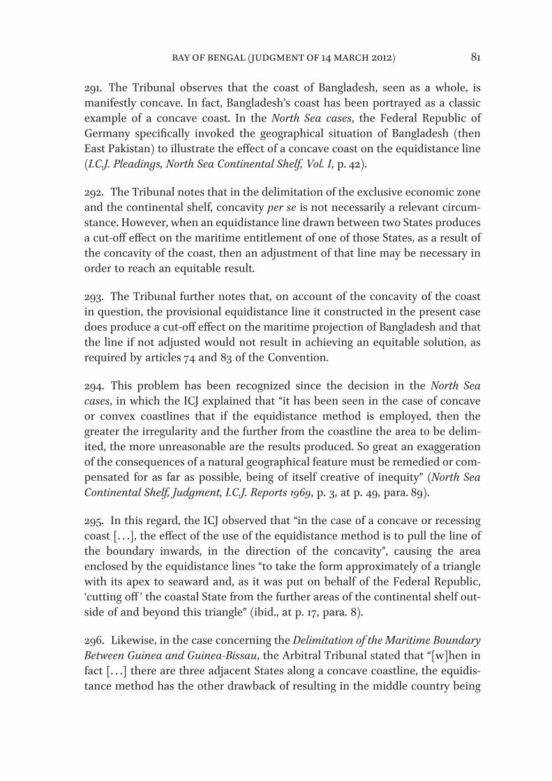
291. The Tribunal observes that the coast of Bangladesh, seen as a whole, is manifestly concave. In fact, Bangladesh’s coast has been portrayed as a classic example of a concave coast. In the North Sea cases, the Federal Republic of Germany specifijically invoked the geographical situation of Bangladesh (then East Pakistan) to illustrate the efffect of a concave coast on the equidistance line (I.C.J. Pleadings, North Sea Continental Shelf, Vol. I, p. 42).
292. The Tribunal notes that in the delimitation of the exclusive economic zone and the continental shelf, concavity per se is not necessarily a relevant circum-stance. However, when an equidistance line drawn between two States produces a cut-offf efffect on the maritime entitlement of one of those States, as a result of the concavity of the coast, then an adjustment of that line may be necessary in order to reach an equitable result.
293. The Tribunal further notes that, on account of the concavity of the coast in question, the provisional equidistance line it constructed in the present case does produce a cut-offf efffect on the maritime projection of Bangladesh and that the line if not adjusted would not result in achieving an equitable solution, as required by articles 74 and 83 of the Convention.
294. This problem has been recognized since the decision in the North Sea
cases, in which the ICJ explained that “it has been seen in the case of concave or convex coastlines that if the equidistance method is employed, then the greater the irregularity and the further from the coastline the area to be delim-ited, the more unreasonable are the results produced. So great an exaggeration of the consequences of a natural geographical feature must be remedied or com-pensated for as far as possible, being of itself creative of inequity” (North Sea
Continental Shelf, Judgment, I.C.J. Reports 1969, p. 3, at p. 49, para. 89).
295. In this regard, the ICJ observed that “in the case of a concave or recessing coast [. . .], the efffect of the use of the equidistance method is to pull the line of the boundary inwards, in the direction of the concavity”, causing the area enclosed by the equidistance lines “to take the form approximately of a triangle with its apex to seaward and, as it was put on behalf of the Federal Republic, ‘cutting offf ’ the coastal State from the further areas of the continental shelf out-side of and beyond this triangle” (ibid., at p. 17, para. 8).
296. Likewise, in the case concerning the Delimitation of the Maritime Boundary
Between Guinea and Guinea-Bissau, the Arbitral Tribunal stated that “[w]hen in fact [. . .] there are three adjacent States along a concave coastline, the equidis-tance method has the other drawback of resulting in the middle country being
bay of bengal (judgment of 14 march 2012) 81
enclaved by the other two and thus prevented from extending its maritime ter-ritory as far seaward as international law permits”. (Decision of 14 February 1985,
ILR, Vol. 77, p. 635, at p. 682, para. 104).
297. The Tribunal fijinds that the concavity of the coast of Bangladesh is a rele-vant circumstance in the present case, because the provisional equidistance line as drawn produces a cut-offf efffect on that coast requiring an adjustment of that line.
St. Martin’s Island
298. Bangladesh argues that St. Martin’s Island is one of the important geo-graphical features in the present case and that “[a]ny line of delimitation that would ignore [this island] is inherently and necessarily inequitable”.
299. Bangladesh maintains that “if, contrary to [its] view, equidistance is not rejected,” then St Martin’s Island must be given full weight in any solution based on an equidistance line and “that even this is not enough to achieve the equi-table solution that is required by the 1982 Convention”.
300. Bangladesh submits that, “whether or not an island can be characterized as being ‘in front of’ one coast or another does not in itself determine whether it is a special or a relevant circumstance”. It refers in this regard to the Case
concerning the Delimitation of the Continental Shelf between United Kingdom of
Great Britain and Northern Ireland, and the French Republic, in which the Court of Arbitration observed that the pertinent question is whether an island would produce “an inequitable distortion of the equidistance line producing dispropor-tionate efffects on the areas of shelf accruing to the two States” (Decision of 30
June 1977, RIAA, Vol. XVIII, p. 3, at p. 113, para. 243).
301. Bangladesh submits that “St. Martin’s Island is as much in front of the Bangladesh coast as it is in front of Myanmar’s coast” and states that the case law supports this view. In this regard Bangladesh notes that Myanmar describes the French island of Ushant as being located in front of the French coast, when in fact Ushant lies 10 miles offf France’s Brittany coast, further than St. Martin’s Island is from Bangladesh, and observes moreover that the Scilly Isles are 21 miles offf the United Kingdom coast.
bay of bengal (judgment of 14 march 2012) 82

302. Bangladesh states that “Myanmar’s proposition that a fijinding of special or relevant circumstance is more likely when an island lies closer to the mainland is wrong” and that, “[i]n fact, it is when islands lie outside a State’s 12-[nm] ter-ritorial sea that they have been treated as relevant circumstances and given less than full efffect in the [exclusive economic zone] and continental shelf delimitations”.
303. Bangladesh contends that what really matters is a “contextualized assess-ment” of an island’s efffect in the particular circumstances of a given case and that, to the contrary of what Myanmar claims, it is the elimination of St. Martin’s Island that disproportionately afffects Myanmar’s delimitation exercise, and ren-ders it even more inequitable than it already is.
304. Responding to Myanmar’s contention that no island in a position analo-gous to that of St. Martin’s Island has ever been considered as a relevant circum-stance, Bangladesh, citing jurisprudence in support, states that:
[t]his is the efffect, or the lack of efffect, that was given to the following islands:
– the Channel Islands in the case of Delimitation of the continental shelf
between France and the United Kingdom in 1977;
– the island of Djerba in the case of Tunisia v. Libya settled in 1982;
– the island of Filfla in the case of Libya v. Malta settled in 1985;
– the island of Abu Musa in the award between Dubai and Sharjah in 1981;
– the Yemeni Islands in the arbitration between Eritrea v. Yemen in 1999;
– the island of Qit at Jaradah in the case of Qatar v. Bahrain in 2001;
– Sable Island in the arbitration of 2002 between the province of Newfoundland and Labrador;
bay of bengal (judgment of 14 march 2012) 83
– Serpent’s Island in the case of Romania v. Ukraine in 2009;
– and the cays in the case of Nicaragua v. Honduras in 2007.
305. Bangladesh notes that the ICJ and arbitral tribunals have developed a clear and common approach to the determination of whether an island exerts such a distorting efffect on the provisional equidistance line and must be disregarded or given less than full weight in the delimitation.
306. Bangladesh explains further that “[t]wo elements are required” for the island to be disregarded or given less than full weight:
(1) the deflection of the equidistance line directly across another State’s coastal front; and (2) the cut-offf of that State’s seaward access.
307. Bangladesh is of the view that a provisional equidistance line that includes St. Martin’s “does cut across somebody’s coastal front, and does cause a signifiji-cant cut-offf efffect – but the efffect is not on Myanmar”. It is for Bangladesh, not Myanmar, that the provisional equidistance line needs to be adjusted so as to achieve the equitable solution required by the Convention.
308. Bangladesh explains that the pertinent question is not whether a particular feature afffects the provisional equidistance line but whether it distorts the line and concludes by stating that “St Martin’s does not distort the line”.
309. Myanmar, in turn, emphasizes “the unique position of St Martin’s Island, which has three characteristic elements: it is close to the land boundary and therefore to the starting point of the equidistance line; it has the very excep-tional feature of being on the wrong side of the equidistance line and also on the wrong side of the bisector claimed by Bangladesh; and, fijinally, the mainland coasts to be delimited are adjacent, not opposite”. Myanmar contends that “[t]hose three elements together create a serious, very excessive distorting efffect on delimitation”.
bay of bengal (judgment of 14 march 2012) 84
310. Myanmar notes that “Bangladesh has never included St. Martin’s Island in its coastal façade or in the description of its relevant coast”, Myanmar points out that Bangladesh had stated in its Reply that “its relevant coast extends, from west to east, from the land boundary terminus with India to the land boundary terminus on the other side on the Naaf River” and had not mentioned St. Martin’s Island. Myanmar points out in this regard that “[t]his makes even more curious the claim made [. . .] that the island is ‘an integral part of the Bangladesh coast’ ”.
311. Myanmar observes that the location of St. Martin’s Island and the efffect that it produces “make it a special circumstance in the case of the delimitation of the territorial sea”, which explains the care taken by Myanmar to give it the efffect that is most appropriate to its unique location; and “the same considerations lead to it not being accorded more efffect in the framework of the delimitation of the exclusive economic zones”.
312. On the issue of the efffect that islands have on delimitation of the exclusive economic zone and the continental shelf, Myanmar points out that if one looks “closely at how case law has applied the methodology, [. . .] no island in the posi-tion of St Martin’s Island has ever been considered, in the fijirst stage of the pro-cess, as an island that should have efffect in drawing an equidistance line beyond the territorial sea, or in the second stage of the process as a relevant circumstance”.
313. Myanmar asserts that “[i]n almost all the cases that have been adjudged, the islands in question [. . .] have not been considered to be coastal islands” and “were not given any efffect on the construction of the equidistance line beyond the territorial sea”.
314. Myanmar points out that St. Martin’s Island, which is 5 kilometres long, would by itself generate at least 13,000 square kilometres of maritime area for Bangladesh in the framework of the delimitation between continental masses, a result which, according to Myanmar, is manifestly disproportionate.
315. Myanmar argues that “if [. . .] efffect were to be given to St. Martin’s Island” in the delimitation of the exclusive economic zone and the continental shelf between Myanmar and Bangladesh, “this would produce a disproportionate result”, citing the Dubai/Sharjah Border Arbitration (Award of 19 October 1981, ILR, Vol. 91, p. 543, at p. 677), the case concerning the Continental Shelf (Libyan
Arab Jamahiriya/Malta) ( Judgment, I.C.J. Reports 1985, p. 13, at p. 48, para. 64), the case concerning Maritime Delimitation and Territorial Questions between
Qatar and Bahrain (Merits, Judgment, I.C.J. Reports 2001, p. 40, at pp. 104-109,
bay of bengal (judgment of 14 march 2012) 85
para. 219) and the Black Sea case (Maritime Delimitation in the Black Sea (Romania
v. Ukraine), Judgment, I.C.J. Reports 2009, p. 61, at p. 122-128, para. 185).
* * *316. The Tribunal will now consider whether St. Martin’s Island, in the circum-stances of this case, should be considered a relevant circumstance warranting an adjustment of the provisional equidistance line.
317. The Tribunal observes that the efffect to be given to an island in the delim-itation of the maritime boundary in the exclusive economic zone and the con-tinental shelf depends on the geographic realities and the circumstances of the specifijic case. There is no general rule in this respect. Each case is unique and requires specifijic treatment, the ultimate goal being to reach a solution that is equitable.
318. St. Martin’s Island is an important feature which could be considered a relevant circumstance in the present case. However, because of its location, giv-ing efffect to St. Martin’s Island in the delimitation of the exclusive economic zone and the continental shelf would result in a line blocking the seaward pro-jection from Myanmar’s coast in a manner that would cause an unwarranted distortion of the delimitation line. The distorting efffect of an island on an equi-distance line may increase substantially as the line moves beyond 12 nm from the coast.
319. For the foregoing reasons, the Tribunal concludes that St. Martin’s Island is not a relevant circumstance and, accordingly, decides not to give any efffect to it in drawing the delimitation line of the exclusive economic zone and the conti-nental shelf.
Bengal depositional system
320. As regards the Bengal depositional system, Bangladesh states that the physical, geological and geomorphological connection between Bangladesh’s land mass and the Bay of Bengal sea floor is so clear, so direct and so pertinent, that adopting a boundary in the area within 200 nm that would cut offf Bangladesh, and deny it access to, and rights in the area beyond, would constitute a grievous inequity.
321. Myanmar rejects Bangladesh’s contention that the Bengal depositional sys-tem is a relevant circumstance, stating that this is a “very curious” special cir-cumstance. It points out that Bangladesh itself admits that within 200 nm
bay of bengal (judgment of 14 march 2012) 86
entitlement is, by operation of article 76, paragraph 1, of the Convention, deter-mined purely by reference to distance from the coast.
* * *322. The Tribunal does not consider that the Bengal depositional system is rel-evant to the delimitation of the exclusive economic zone and the continental shelf within 200 nm. The location and direction of the single maritime boundary applicable both to the seabed and subsoil and to the superjacent waters within the 200 nm limit are to be determined on the basis of geography of the coasts of the Parties in relation to each other and not on the geology or geomorphology of the seabed of the delimitation area.
Adjustment of the provisional equidistance line
323. As noted by the Tribunal in paragraph 291, the coast of Bangladesh between its land boundary terminus with Myanmar at the mouth of the Naaf River and its land boundary terminus with India is decidedly concave. This concavity causes the provisional equidistance line to cut across Bangladesh’s coastal front. This produces a pronounced cut-offf efffect on the southward maritime projec-tion of Bangladesh’s coast that continues throughout much of the delimitation area.
324. The Tribunal recalls that it has decided earlier in this Judgment (see para-graph 297) that the concavity which results in a cut-offf efffect on the maritime projection of Bangladesh is a relevant circumstance, requiring an adjustment of the provisional equidistance line.
325. The Tribunal, therefore, takes the position that, while an adjustment must be made to its provisional equidistance line to abate the cut-offf efffect of the line on Bangladesh’s concave coast, an equitable solution requires, in light of the coastal geography of the Parties, that this be done in a balanced way so as to avoid drawing a line having a converse distorting efffect on the seaward projec-tion of Myanmar’s coastal façade.
326. The Tribunal agrees that the objective is a line that allows the relevant coasts of the Parties “to produce their efffects, in terms of maritime entitlements, in a reasonable and mutually balanced way” (Maritime Delimitation in the Black
Sea (Romania v. Ukraine), Judgment, I.C.J. Reports 2009, p. 61, at p. 127, para. 201).
bay of bengal (judgment of 14 march 2012) 87
327. The Tribunal notes that there are various adjustments that could be made within the relevant legal constraints to produce an equitable result. As the Arbitral Tribunal observed in the Arbitration between Barbados and Trinidad
and Tobago, “[t]here are no magic formulas” in this respect (Decision of 11 April
2006, RIAA, Vol. XXVII, p. 147, at p. 243, para. 373).
328. In the case concerning the Continental Shelf (Libyan Arab Jamahiriya/
Malta) the position of the line but not its direction was adjusted, in the case concerning Maritime Delimitation in the Area between Greenland and Jan Mayen the position and direction of the line were adjusted, and in the Arbitration
between Barbados and the Republic of Trinidad and Tobago, the line was deflected at the point suggested by the relevant circumstances, and its direction was determined in light of those circumstances. The approach taken in this arbitra-tion would appear to be suited to the geographic circumstances of the present case, which entails a lateral delimitation line extending seaward from the coasts of the Parties.
329. The Tribunal decides that, in view of the geographic circumstances in the present case, the provisional equidistance line is to be deflected at the point where it begins to cut offf the seaward projection of the Bangladesh coast. The direction of the adjustment is to be determined in the light of those circumstances.
330. The fact that this adjustment may afffect most of the line in the present case is not an impediment, so long as the adjustment is tailored to the relevant circumstance justifying it and the line produces an equitable solution. The Tribunal notes that in the Arbitration between Barbados and the Republic of
Trinidad and Tobago it was concluded that only part of the line required adjust-ment, while the ICJ adjusted the lines in their entirety in the cases concerning the Continental Shelf (Libyan Arab Jamahiriya/Malta) and Maritime Delimitation
in the Area between Greenland and Jan Mayen.
331. The Tribunal, therefore, determines that the adjustment of the provisional equidistance line should commence at point X with coordinates 20° 03’ 32.0” N, 91°50’ 31.8” E, where the equidistance line begins to cut offf the southward pro-jection of the coast of Bangladesh. The Tribunal has selected the point on the provisional equidistance line that is due south of the point on Kutubdia Island at which the direction of the coast of Bangladesh shifts markedly from north-
bay of bengal (judgment of 14 march 2012) 88

west to west, as indicated by the lines drawn by the Tribunal to identify the relevant coasts of Bangladesh.
332. Having concluded that the overlapping projections from the coasts of the Parties extend to the limits of their respective exclusive economic zones and continental shelves outside the area in which a third party may have rights, the Tribunal considered how to make the adjustment to the provisional equidis-tance line in that light.
333. The projection southward from the coast of Bangladesh continues through-out the delimitation area. There is thus a continuing need to avoid cut-offf efffects on this projection. In the geographic circumstances of this case it is not neces-sary to change the direction of the adjusted line as it moves away from the coasts of the Parties.
334. The Tribunal accordingly believes that there is reason to consider an adjustment of the provisional equidistance line by drawing a geodetic line start-ing at a particular azimuth. In the view of the Tribunal the direction of any plausible adjustment of the provisional equidistance line would not difffer sub-stantially from a geodetic line starting at an azimuth of 215°. A signifijicant shift in the angle of that azimuth would result in cut-offf efffects on the projections from the coast of one Party or the other. A shift toward the north-west would produce a line that does not adequately remedy the cut-offf efffect of the provi-sional equidistance line on the southward projection of the coast of Bangladesh, while a shift in the opposite direction would produce a cut-offf efffect on the seaward projection of Myanmar’s coast.
335. The Tribunal is satisfijied that such an adjustment, commencing at the start-ing point X identifijied in paragraph 331, remedies the cut-offf efffect on the south-ward projection of the coast of Bangladesh with respect to both the exclusive economic zone and the continental shelf, and that it does so in a consistent manner that allows the coasts of both Parties to produce their efffects in a rea-sonable and balanced way.
336. The Tribunal notes that as the adjusted line moves seaward of the broad curvature formed by the relevant coasts of the Parties, the balanced efffects it produces in relation to those coasts are confijirmed by the fact that it intersects the 200 nm limit of the exclusive economic zone of Myanmar at a point that is nearly equidistant from Cape Negrais on Myanmar’s coast and the terminus of Bangladesh’s land boundary with India.
bay of bengal (judgment of 14 march 2012) 89
Delimitation line
337. The delimitation line for the exclusive economic zone and the continental shelf of the Parties within 200 nm begins at point 9 with coordinates 20° 26’ 39.2” N, 92° 9’ 50.7” E, the point at which the envelope of arcs of the 12 nm limit of Bangladesh’s territorial sea around St. Martin’s Island intersects with the equidistance line referred to in paragraphs 271-274.
338. From point 9, the delimitation line follows a geodetic line until point 10(T1) with coordinates 20° 13’ 06.3” N, 92° 00’ 07.6” E.
339. From point 10(T1), the delimitation line follows a geodetic line until point 11(X) with coordinates 20° 03’ 32.0” N, 91° 50’ 31.8” E, at which the adjustment of the line begins to take efffect as determined by the Tribunal in paragraph 331.
340. From point 11(X), the delimitation line continues as a geodetic line starting at an azimuth of 215° until it reaches a point which is located 200 nm from the baselines from which the breadth of the territorial sea of Bangladesh is measured.
bay of bengal (judgment of 14 march 2012) 90

WGS 84
109
INDIA BANGLADESH
MYANMAR
prepared for illustrative purposes only.are presented in simplified form, has been
This sketch-map, on which the coasts
Sketch-map No. 6:
Mercator Projection (20° N)
equidistance lineAdjustedEEZ/CS
11(X)
bay of bengal (judgment of 14 march 2012) 91

IX. Continental shelf beyond 200 nautical miles
Jurisdiction to delimit the continental shelf in its entirety
341. While the Parties are in agreement that the Tribunal is requested to delimit the continental shelf between them in the Bay of Bengal within 200 nm, they disagree as to whether the Tribunal has jurisdiction to delimit the continental shelf beyond 200 nm and whether the Tribunal, if it determines that it has juris-diction to do so, should exercise such jurisdiction.
342. As pointed out in paragraph 45, Myanmar does not dispute that “as a mat-ter of principle, the delimitation of the continental shelf, including the shelf beyond 200 [nm], could fall within the jurisdiction of the Tribunal”. However, it raises the issue of the advisability in the present case of the exercise by the Tribunal of its jurisdiction with respect to the delimitation of the continental shelf beyond 200 nm.
343. Myanmar states in its Counter Memorial that the question of the jurisdic-tion of the Tribunal regarding the delimitation of the continental shelf beyond 200 nm in general should not arise in the present case because the delimitation line, in its view, terminates well before reaching the 200 nm limit from the base-lines from which the territorial sea is measured.
344. At the same time Myanmar submits that “[e]ven if the Tribunal were to decide that there could be a single maritime boundary beyond 200 [nm] (quod
non), the Tribunal would still not have jurisdiction to determine this line because any judicial pronouncement on these issues might prejudice the rights of third parties and also those relating to the international seabed area”.
345. Myanmar further submits that “[a]s long as the outer limit of the continen-tal shelf has not been established on the basis of the recommendations” of the Commission on the Limits of the Continental Shelf (hereinafter “the Commission”), “the Tribunal, as a court of law, cannot determine the line of delimitation on a hypothetical basis without knowing what the outer limits are”. It argues in this regard that:
A review of a State’s submission and the making of recommendations by the Commission on this submission is a necessary prerequisite for any determi-nation of the outer limits of the continental shelf of a coastal State ‘on the basis of these recommendations’ under article 76 (8) of UNCLOS and the area of continental shelf beyond 200 [nm] to which a State is potentially entitled; this, in turn, is a necessary precondition to any judicial determina-
bay of bengal (judgment of 14 march 2012) 92

tion of the division of areas of overlapping sovereign rights to the natural resources of the continental shelf beyond 200 [nm]. [. . .] To reverse the pro-cess [. . .], to adjudicate with respect to rights the extent of which is unknown, would not only put this Tribunal at odds with other treaty bodies, but with the entire structure of the Convention and the system of international ocean governance.
346. In support of its position, Myanmar refers to the Arbitral Award in the Case
concerning the Delimitation of Maritime Areas between Canada and France of 10 June 1992, which states: “[i]t is not possible for a tribunal to reach a decision by assuming hypothetically the eventuality that such rights will in fact exist” (Decision of 10 June 1992, ILM, Vol. 31 (1992), p. 1145, at p. 1172, para. 81).
347. Myanmar asserts that in the case concerning Territorial and Maritime
Dispute between Nicaragua and Honduras in the Caribbean Sea (Nicaragua v. Honduras), the ICJ declined to delimit the continental shelf beyond 200 nm between Nicaragua and Honduras because the Commission had not yet made recommendations to the two countries regarding the continental shelf beyond 200 nm.
348. During the oral proceedings Myanmar clarifijied its position, stating, inter
alia, that in principle it did not question the jurisdiction of the Tribunal. The Parties accepted the Tribunal’s jurisdiction on the same terms, in accordance with the provisions of article 287, paragraph 1, of the Convention, “for the settle-ment of dispute [. . .] relating to the delimitation of maritime boundary between the two countries in the Bay of Bengal”. According to Myanmar, the only prob-lem that arose concerned the possibility that the Tribunal might in this matter exercise this jurisdiction and decide on the delimitation of the continental shelf beyond 200 nm.
349. Myanmar further observed that if the Tribunal “nevertheless were to con-sider the Application admissible on this point – quod non – you could not but defer judgment on this aspect of the matter until the Parties, in accordance with Article 76 of the Convention, have taken a position on the recommendations of the Commission concerning the existence of entitlements of the two Parties to the continental shelf beyond 200 [nm] and, if such entitlements exist, on their
bay of bengal (judgment of 14 march 2012) 93
seaward extension – i.e., on the outer (not lateral, outer) limits of the continen-tal shelf of the two countries”.
350. Bangladesh is of the view that the Tribunal is expressly empowered by the Convention to adjudicate disputes between States arising under articles 76 and 83, in regard to the delimitation of the continental shelf. As the Convention draws no distinction in this regard between jurisdiction over the inner part of the continental shelf, i.e., that part within 200 nm, and the part beyond that distance, according to Bangladesh, delimitation of the entire continental shelf is covered by article 83, and the Tribunal plainly has jurisdiction to carry out delimitation beyond 200 nm.
351. Responding to Myanmar’s argument that “in any event, the question of delimiting the shelf beyond 200 [nm] does not arise because the delimitation line terminates well before reaching the 200 [nm] limit”, Bangladesh states that “Myanmar’s argument that Bangladesh has no continental shelf beyond 200 [nm] is based instead on the proposition that once the area within 200 [nm] is delim-ited, the terminus of Bangladesh’s shelf falls short of the 200 [nm] limit”. Bangladesh contends that “[t]his can only be a valid argument if the Tribunal fijirst accepts Myanmar’s arguments in favour of an equidistance line within 200 [nm]. Such an outcome would require the Tribunal to disregard entirely the relevant circumstances relied upon by Bangladesh”.
352. With reference to Myanmar’s argument regarding the rights of third par-ties, Bangladesh states that a potential overlapping claim of a third State cannot deprive the Tribunal of jurisdiction to delimit the maritime boundary between two States that are subject to the jurisdiction of the Tribunal, because third States are not bound by the Tribunal’s judgment and their rights are unafffected by it. Bangladesh points out that so far as third States are concerned, a delimita-tion judgment by the Tribunal is merely res inter alios acta and that this assur-ance is provided in article 33, paragraph 2, of the Statute.
353. Bangladesh also observes that Myanmar’s contention “with regard to the international seabed area disregards its own submission to the CLCS, which makes clear that the outer limits of the continental shelf vis-à-vis the interna-tional seabed are far removed from the maritime boundary with Bangladesh”.
bay of bengal (judgment of 14 march 2012) 94
354. Bangladesh observes that with respect to the potential areas of overlap with India, Myanmar accepts that even if the Tribunal cannot fijix a tripoint between three States, it can indicate the “general direction for the fijinal part of the maritime boundary between Myanmar and Bangladesh”, and that doing so would be “in accordance with the well-established practise” of international courts and tribunals.
355. In summarizing its position on the issue of the rights of third parties and the jurisdiction of the Tribunal, Bangladesh states that:
1. [. . .]
2. The delimitation by the Tribunal of a maritime boundary in the conti-nental shelf beyond 200 [nm] does not prejudice the rights of third parties. In the same way that international courts and tribunals have consistently exercised jurisdiction where the rights of third States are involved, ITLOS may exercise jurisdiction, even if the rights of the international community to the international seabed were involved, which in this case they are not.
3. With respect to the area of shelf where the claims of Bangladesh and Myanmar overlap with those of India, the Tribunal need only determine which of the two Parties in the present proceeding has the better claim, and efffect a delimitation that is only binding on Bangladesh and Myanmar. Such a delimitation as between the two Parties to this proceeding would not be binding on India.
356. Bangladesh observes that there is no conflict between the roles of the Tribunal and the Commission in regard to the continental shelf and that, to the contrary, the roles are complementary. Bangladesh also states that the Tribunal has jurisdiction to delimit boundaries within the outer continental shelf and that the Commission makes recommendations as to the delineation of the outer limits of the continental shelf with the Area, as defijined in article 1, paragraph 1, of the Convention, provided there are no disputed claims between States with opposite or adjacent coasts.
357. Bangladesh adds that the Commission may not make any recommenda-tions on the outer limits until any such dispute is resolved by the Tribunal or another judicial or arbitral body or by agreement between the parties, unless the parties give their consent that the Commission review their submissions.
bay of bengal (judgment of 14 march 2012) 95

According to Bangladesh, in the present case, “the Commission is precluded from acting due to the Parties’ disputed claims in the outer continental shelf and the refusal by at least one of them (Bangladesh) to consent to the Commission’s actions”.
358. Bangladesh points out that if Myanmar’s argument were accepted, the Tribunal would have to wait for the Commission to act and the Commission would have to wait for the Tribunal to act. According to Bangladesh, the result would be that, whenever parties are in dispute in regard to the continental shelf beyond 200 nm, the compulsory procedures entailing binding decisions under Part XV, Section 2, of the Convention would have no practical application. Bangladesh adds that “[i]n efffect, the very object and purpose of the UNCLOS dispute settlement procedures would be negated. Myanmar’s position opens a jurisdictional black hole into which all disputes concerning maritime boundar-ies in the outer continental shelf would forever disappear”.
359. Summarizing its position, Bangladesh states that in portraying recommen-dations by the Commission as a prerequisite to the exercise of jurisdiction by the Tribunal, Myanmar sets forth a “circular argument” that would make the exercise by the Tribunal of its jurisdiction with respect to the continental shelf beyond 200 nm impossible, which is inconsistent with Part XV and with article 76, paragraph 10, of the Convention.
* * *360. The Tribunal will now consider whether it has jurisdiction to delimit the continental shelf beyond 200 nm.
361. Article 76 of the Convention embodies the concept of a single continental shelf. In accordance with article 77, paragraphs 1 and 2, of the Convention, the coastal State exercises exclusive sovereign rights over the continental shelf in its entirety without any distinction being made between the shelf within 200 nm and the shelf beyond that limit. Article 83 of the Convention, concerning the delimitation of the continental shelf between States with opposite or adjacent coasts, likewise does not make any such distinction.
362. In this regard, the Tribunal notes that in the Arbitration between Barbados
and Trinidad and Tobago, the Arbitral Tribunal decided that “the dispute to be dealt with by the Tribunal includes the outer continental shelf, since [. . .] it either forms part of, or is sufffijiciently closely related to, the dispute [. . .] and [. . .] in any event there is in law only a single ‘continental shelf ’ rather than an inner
bay of bengal (judgment of 14 march 2012) 96
continental shelf and a separate extended or outer continental shelf ” (Decision
of 11 April 2006, RIAA, Vol. XXVII, p. 147, at pp. 208-209, para. 213).
363. For the foregoing reasons, the Tribunal fijinds that it has jurisdiction to delimit the continental shelf in its entirety. The Tribunal will now consider whether, in the circumstances of this case, it is appropriate to exercise that jurisdiction.
Exercise of jurisdiction
364. The Tribunal will fijirst address Myanmar’s argument that Bangladesh’s con-tinental shelf cannot extend beyond 200 nm because the maritime area in which Bangladesh enjoys sovereign rights with respect to natural resources of the con-tinental shelf does not extend up to 200 nm.
365. The Tribunal notes that this argument cannot be sustained, given its deci-sion, as set out in paragraph 339, that the delimitation line of the exclusive eco-nomic zone and the continental shelf reaches the 200 nm limit.
366. The Tribunal will now turn to the question of whether the exercise of its jurisdiction could prejudice the rights of third parties.
367. The Tribunal observes that, as provided for in article 33, paragraph 2, of the Statute, its decision “shall have no binding force except between the parties in respect of that particular dispute”. Accordingly, the delimitation of the conti-nental shelf by the Tribunal cannot prejudice the rights of third parties. Moreover, it is established practice that the direction of the seaward segment of a maritime boundary may be determined without indicating its precise terminus, for exam-ple by specifying that it continues until it reaches the area where the rights of third parties may be afffected.
368. In addition, as far as the Area is concerned, the Tribunal wishes to observe that, as is evident from the Parties’ submissions to the Commission, the conti-nental shelf beyond 200 nm that is the subject of delimitation in the present case is situated far from the Area. Accordingly, the Tribunal, by drawing a line of delimitation, will not prejudice the rights of the international community.
bay of bengal (judgment of 14 march 2012) 97
369. The Tribunal will now examine the issue of whether it should refrain in the present case from exercising its jurisdiction to delimit the continental shelf beyond 200 nm until such time as the outer limits of the continental shelf have been established by each Party pursuant to article 76, paragraph 8, of the Convention or at least until such time as the Commission has made recommen-dations to each Party on its submission and each Party has had the opportunity to consider its reaction to the recommendations.
370. The Tribunal wishes to point out that the absence of established outer lim-its of a maritime zone does not preclude delimitation of that zone. Lack of agreement on baselines has not been considered an impediment to the delimi-tation of the territorial sea or the exclusive economic zone notwithstanding the fact that disputes regarding baselines afffect the precise seaward limits of these maritime areas. However, in such cases the question of the entitlement to mar-itime areas of the parties concerned did not arise.
371. The Tribunal must therefore consider whether it is appropriate to proceed with the delimitation of the continental shelf beyond 200 nm given the role of the Commission as provided for in article 76, paragraph 8, of the Convention and article 3, paragraph 1, of Annex II to the Convention.
372. Pursuant to article 31 of the Vienna Convention, the Convention is to be interpreted in good faith in accordance with the ordinary meaning of its terms in their context and in the light of its object and purpose. As stated in the Advisory Opinion of the Seabed Disputes Chamber, article 31 of the Vienna Convention is to be considered “as reflecting customary international law” (Responsibilities and obligations of States sponsoring persons and entities with
respect to activities in the Area (Request for Advisory Opinion submitted to the
Seabed Disputes Chamber), 1 February 2011, para. 57).
373. The Convention sets up an institutional framework with a number of bodies to implement its provisions, including the Commission, the International Seabed Authority and this Tribunal. Activities of these bodies are complementary to each other so as to ensure coherent and efffijicient implementation of the Convention. The same is true of other bodies referred to in the Convention.
bay of bengal (judgment of 14 march 2012) 98

374. The right of the coastal State under article 76, paragraph 8, of the Convention to establish fijinal and binding limits of its continental shelf is a key element in the structure set out in that article. In order to realize this right, the coastal State, pursuant to article 76, paragraph 8, is required to submit information on the limits of its continental shelf beyond 200 nm to the Commission, whose mandate is to make recommendations to the coastal State on matters related to the establishment of the outer limits of its continental shelf. The Convention stipulates in article 76, paragraph 8, that the “limits of the shelf established by a coastal State on the basis of these recommendations shall be fijinal and binding”.
375. Thus, the Commission plays an important role under the Convention and has a special expertise which is reflected in its composition. Article 2 of Annex II to the Convention provides that the Commission shall be composed of experts in the fijield of geology, geophysics or hydrography. Article 3 of Annex II to the Convention stipulates that the functions of the Commission are, inter alia, to consider the data and other material submitted by coastal States concerning the outer limits of the continental shelf in areas where those limits extend beyond 200 nm and to make recommendations in accordance with article 76 of the Convention.
376. There is a clear distinction between the delimitation of the continental shelf under article 83 and the delineation of its outer limits under article 76. Under the latter article, the Commission is assigned the function of making rec-ommendations to coastal States on matters relating to the establishment of the outer limits of the continental shelf, but it does so without prejudice to delimitation of maritime boundaries. The function of settling disputes with respect to delimitation of maritime boundaries is entrusted to dispute settle-ment procedures under article 83 and Part XV of the Convention, which include international courts and tribunals.
377. There is nothing in the Convention or in the Rules of Procedure of the Commission or in its practice to indicate that delimitation of the continental shelf constitutes an impediment to the performance by the Commission of its functions.
378. Article 76, paragraph 10, of the Convention states that “[t]he provisions of this article are without prejudice to the question of delimitation of the continen-tal shelf between States with opposite or adjacent coasts”. This is further con-fijirmed by article 9 of Annex II, to the Convention, which states that the “actions of the Commission shall not prejudice matters relating to delimitation of bound-aries between States with opposite or adjacent coasts”.
bay of bengal (judgment of 14 march 2012) 99

379. Just as the functions of the Commission are without prejudice to the ques-tion of delimitation of the continental shelf between States with opposite or adjacent coasts, so the exercise by international courts and tribunals of their jurisdiction regarding the delimitation of maritime boundaries, including that of the continental shelf, is without prejudice to the exercise by the Commission of its functions on matters related to the delineation of the outer limits of the continental shelf.
380. Several submissions made to the Commission, beginning with the fijirst sub-mission, have included areas in respect of which there was agreement between the States concerned efffecting the delimitation of their continental shelf beyond 200 nm. However, unlike in the present case, in all those situations delimitation has been efffected by agreement between States, not through international courts and tribunals.
381. In this respect, the Tribunal notes the positions taken in decisions by inter-national courts and tribunals.
382. The Arbitral Tribunal in the Arbitration between Barbados and the Republic
of Trinidad and Tobago found that its jurisdiction included the delimitation of the maritime boundary of the continental shelf beyond 200 nm (Decision of
11 April 2006, RIAA, Vol. XXVII, p. 147, at p. 209, para. 217). The Arbitral Tribunal, in that case, did not exercise its jurisdiction stating that:
As will become apparent, however, the single maritime boundary which the Tribunal has determined is such that, as between Barbados and Trinidad and Tobago, there is no single maritime boundary beyond 200 nm. (ibid., at p. 242, para. 368).
383. In the case concerning Territorial and Maritime Dispute between Nicaragua
and Honduras in the Caribbean Sea (Nicaragua v. Honduras), the ICJ declared that:
The Court may accordingly, without specifying a precise endpoint, delimit the maritime boundary and state that it extends beyond the 82nd meridian without afffecting third-States rights. It should also be noted in this regard that in no case may the line be interpreted as extending more than 200 [nm] from the baselines from which the breadth of the territorial sea is measured; any claim of continental shelf rights beyond 200 miles must be in accordance with Article 76 of UNCLOS and reviewed by the Commission on the Limits of the Continental Shelf established thereunder. ( Judgment,
I.C.J. Reports 2007, p. 659, at p. 759, para. 319).
bay of bengal (judgment of 14 march 2012) 100
384. The Tribunal observes that the determination of whether an international court or tribunal should exercise its jurisdiction depends on the procedural and substantive circumstances of each case.
385. Pursuant to rule 46 of the Rules of Procedure of the Commission, in the event that there is a dispute in the delimitation of the continental shelf between States with opposite or adjacent coasts, submissions to the Commission shall be considered in accordance with Annex I to those Rules. Annex I, paragraph 2, provides:
In case there is a dispute in the delimitation of the continental shelf between opposite or adjacent States, or in other cases of unresolved land or maritime disputes, related to the submission, the Commission shall be:
(a) Informed of such disputes by the coastal States making the submission; and
(b) Assured by the coastal States making the submission to the extent pos-sible that the submission will not prejudice matters relating to the delimitation of boundaries between States.
386. Paragraph 5 (a) of Annex I to the same Rules further provides:
5. (a) In cases where a land or maritime dispute exists, the Commission shall not consider and qualify a submission made by any of the States con-cerned in the dispute. However, the Commission may consider one or more submissions in the areas under dispute with prior consent given by all States that are parties to such a dispute.
387. In the present case, Bangladesh informed the Commission by a note ver-bale dated 23 July 2009, addressed to the Secretary-General of the United Nations, that, for the purposes of rule 46 of the Rules of Procedure of the Commission, and of Annex I thereto, there was a dispute between the Parties and, recalling paragraph 5 (a) of Annex I to the Rules, observed that:
given the presence of a dispute between Bangladesh and Myanmar concern-ing entitlement to the parts of the continental shelf in the Bay of Bengal claimed by Myanmar in its submission, the Commission may not “consider and qualify” the submission made by Myanmar without the “prior consent given by all States that are parties to such a dispute”.
bay of bengal (judgment of 14 march 2012) 101
388. Taking into account Bangladesh’s position, the Commission has deferred consideration of the submission made by Myanmar (Statement by the Chairman of the Commission on the progress of work in the Commission, CLCS/64 of 1 October 2009, p. 10, paragraph 40)
389. The Commission also decided to defer the consideration of the submission of Bangladesh,
in order to take into account any further developments that might occur in the intervening period, during which the States concerned might wish to take advantage of the avenues available to them, including provisional arrangements of a practical nature as outlined in annex I to the rules of procedure. (Statement by the Chairman of the Commission on the progress of work in the Commission, CLCS/72 of 16 September 2011, p. 7, paragraph 22)
390. The consequence of these decisions of the Commission is that, if the Tribunal declines to delimit the continental shelf beyond 200 nm under arti-cle 83 of the Convention, the issue concerning the establishment of the outer limits of the continental shelf of each of the Parties under article 76 of the Convention may remain unresolved. The Tribunal notes that the record in this case afffords little basis for assuming that the Parties could readily agree on other avenues available to them so long as their delimitation dispute is not settled.
391. A decision by the Tribunal not to exercise its jurisdiction over the dispute relating to the continental shelf beyond 200 nm would not only fail to resolve a long-standing dispute, but also would not be conducive to the efffijicient opera-tion of the Convention.
392. In the view of the Tribunal, it would be contrary to the object and purpose of the Convention not to resolve the existing impasse. Inaction in the present case, by the Commission and the Tribunal, two organs created by the Convention to ensure the efffective implementation of its provisions, would leave the Parties in a position where they may be unable to benefijit fully from their rights over the continental shelf.
393. The Tribunal observes that the exercise of its jurisdiction in the present case cannot be seen as an encroachment on the functions of the Commission, inasmuch as the settlement, through negotiations, of disputes between States regarding delimitation of the continental shelf beyond 200 nm is not seen as precluding examination by the Commission of the submissions made to it or hindering it from issuing appropriate recommendations.
bay of bengal (judgment of 14 march 2012) 102
394. For the foregoing reasons, the Tribunal concludes that, in order to fulfijil its responsibilities under Part XV, Section 2, of the Convention in the present case, it has an obligation to adjudicate the dispute and to delimit the continental shelf between the Parties beyond 200 nm. Such delimitation is without preju-dice to the establishment of the outer limits of the continental shelf in accor-dance with article 76, paragraph 8, of the Convention.
Entitlement
395. The delimitation of the continental shelf beyond 200 nm in this case entails the interpretation and application of both article 76 and article 83 of the Convention.
396. Article 83 is set forth in paragraph 182 and article 76 reads as follows:
Defijinition of the continental shelf
1. The continental shelf of a coastal State comprises the seabed and subsoil of the submarine areas that extend beyond its territorial sea throughout the natural prolongation of its land territory to the outer edge of the continental margin, or to a distance of 200 [nm] from the baselines from which the breadth of the territorial sea is measured where the outer edge of the con-tinental margin does not extend up to that distance.
2. The continental shelf of a coastal State shall not extend beyond the lim-its provided for in paragraphs 4 to 6.
3. The continental margin comprises the submerged prolongation of the land mass of the coastal State, and consists of the seabed and subsoil of the shelf, the slope and the rise. It does not include the deep ocean floor with its oceanic ridges or the subsoil thereof.
4. (a) For the purposes of this Convention, the coastal State shall establish the outer edge of the continental margin wherever the margin extends beyond 200 [nm] from the baselines from which the breadth of the territo-rial sea is measured, by either:
(i) a line delineated in accordance with paragraph 7 by reference to the outermost fijixed points at each of which the thickness of sedimentary rocks is at least 1 per cent of the shortest distance from such point to the foot of the continental slope; or
bay of bengal (judgment of 14 march 2012) 103
(ii) a line delineated in accordance with paragraph 7 by reference to fijixed points not more than 60 [nm] from the foot of the continental slope.
(b) In the absence of evidence to the contrary, the foot of the continental slope shall be determined as the point of maximum change in the gra-dient at its base.
5. The fijixed points comprising the line of the outer limits of the continental shelf on the seabed, drawn in accordance with paragraph 4 (a)(i) and (ii), either shall not exceed 350 [nm] from the baselines from which the breadth of the territorial sea is measured or shall not exceed 100 [nm] from the 2,500 metre isobath, which is a line connecting the depth of 2,500 metres.
6. Notwithstanding the provisions of paragraph 5, on submarine ridges, the outer limit of the continental shelf shall not exceed 350 [nm] from the base-lines from which the breadth of the territorial sea is measured. This para-graph does not apply to submarine elevations that are natural components of the continental margin, such as its plateaux, rises, caps, banks and spurs.
7. The coastal State shall delineate the outer limits of its continental shelf, where that shelf extends beyond 200 [nm] from the baselines from which the breadth of the territorial sea is measured, by straight lines not exceeding 60 [nm] in length, connecting fijixed points, defijined by coordinates of lati-tude and longitude.
8. Information on the limits of the continental shelf beyond 200 [nm] from the baselines from which the breadth of the territorial sea is measured shall be submitted by the coastal State to the Commission on the Limits of the Continental Shelf set up under Annex II on the basis of equitable geographical representation. The Commission shall make recommendations to coastal States on matters related to the establishment of the outer limits of their continental shelf. The limits of the shelf established by a coastal State on the basis of these recommendations shall be fijinal and binding.
9. The coastal State shall deposit with the Secretary-General of the United Nations charts and relevant information, including geodetic data, perma-nently describing the outer limits of its continental shelf. The Secretary-General shall give due publicity thereto.
bay of bengal (judgment of 14 march 2012) 104
10. The provisions of this Article are without prejudice to the question of delimitation of the continental shelf between States with opposite or adja-cent coasts.
Entitlement and delimitation
397. Delimitation presupposes an area of overlapping entitlements. Therefore, the fijirst step in any delimitation is to determine whether there are entitlements and whether they overlap.
398. While entitlement and delimitation are two distinct concepts addressed respectively in articles 76 and 83 of the Convention, they are interrelated. The Parties also recognize the interrelationship between entitlement and delimita-tion. Bangladesh states that “[t]he Tribunal must answer this question before it can delimit the shelf: does either Party have an entitlement to a continental shelf beyond 200 [nm]?” Likewise, Myanmar observes that “the determination of the entitlements of both States to a continental shelf beyond 200 [nm] and their respective extent is a prerequisite for any delimitation”.
399. Thus the question the Tribunal should fijirst address in the present case is whether the Parties have overlapping entitlements to the continental shelf beyond 200 nm. If not, it would be dealing with a hypothetical question.
400. In the present case, the Parties have made claims to the continental shelf beyond 200 nm which overlap. Part of this area is also claimed by India. Each Party denies the other’s entitlement to the continental shelf beyond 200 nm. Furthermore, Myanmar argues that the Tribunal cannot address the issue of the entitlement of either Bangladesh or Myanmar to a continental shelf beyond 200 nm, as this is an issue that lies solely within the competence of the Commission, not of the Tribunal.
401. Considering the above positions of the Parties, the Tribunal will address the main point disputed by them, namely whether or not they have any entitle-ment to the continental shelf beyond 200 nm. In this regard, the Tribunal will fijirst address the question of whether it can and should in this case determine the entitlements of the Parties to the continental shelf beyond 200 nm. The Tribunal will next consider the positions of the Parties regarding entitlements. It will then analyze the meaning of natural prolongation and its interrelation with that of continental margin. Finally, the Tribunal will determine whether the Parties have entitlements to the continental shelf beyond 200 nm and whether those entitlements overlap. On the basis of these determinations, the
bay of bengal (judgment of 14 march 2012) 105

Tribunal will take a decision on the delimitation of the continental shelf of the Parties beyond 200 nm.
402. The Tribunal will now address the fijirst question, namely, whether it can and should in the present case determine the entitlements of the Parties to the continental shelf beyond 200 nm.
403. Bangladesh argues that the Tribunal is required to decide on the question of entitlements of the Parties to the continental shelf beyond 200 nm. For Bangladesh, “the 1982 Convention requires that ITLOS delimit the areas of outer continental shelf claimed by both Bangladesh and Myanmar by deciding that only Bangladesh, and not Myanmar, has an entitlement to these areas, and by fijixing the maritime boundary separating the continental shelves of the two Parties along the line that is exactly 200 [nm] from Myanmar’s coastline”.
404. Bangladesh further contends that “[i]nsofar as its entitlement to this area of continental shelf overlaps with the claims of Myanmar, it is for ITLOS to determine the validity of the competing claims and delimit an equitable bound-ary taking into account the applicable law, and relevant scientifijic and factual circumstances. These include Bangladesh’s ‘natural prolongation’ throughout the Bay of Bengal and the absence of any natural prolongation on Myanmar’s side”.
405. Myanmar argues that “[t]he Tribunal has no need to and cannot deal with the issue of the entitlement of Bangladesh or of Myanmar to a continental shelf extending beyond 200 [nm]”. In the view of Myanmar, “the determination of the entitlements of both States to a continental shelf beyond 200 [nm] and their respective extent is a prerequisite for any delimitation, and the Commission on the Limits of the Continental Shelf (CLCS) plays a crucial role in this regard”.
* * *406. Regarding the question whether it can and should decide on the entitle-ments of the Parties, the Tribunal fijirst points out the need to make a distinction between the notion of entitlement to the continental shelf beyond 200 nm and that of the outer limits of the continental shelf.
407. It is clear from article 76, paragraph 8, of the Convention that the limits of the continental shelf beyond 200 nm can be established only by the coastal State. Although this is a unilateral act, the opposability with regard to other
bay of bengal (judgment of 14 march 2012) 106
States of the limits thus established depends upon satisfaction of the require-ments specifijied in article 76, in particular compliance by the coastal State with the obligation to submit to the Commission information on the limits of the continental shelf beyond 200 nm and issuance by the Commission of relevant recommendations in this regard. It is only after the limits are established by the coastal State on the basis of the recommendations of the Commission that these limits become “fijinal and binding”.
408. The foregoing does not imply that entitlement to the continental shelf depends on any procedural requirements. As stated in article 77, paragraph 3, of the Convention, “[t]he rights of the coastal State over the continental shelf do not depend on occupation, efffective or notional, or on any express proclamation”.
409. A coastal State’s entitlement to the continental shelf exists by the sole fact that the basis of entitlement, namely, sovereignty over the land territory, is pres-ent. It does not require the establishment of outer limits. Article 77, paragraph 3, of the Convention confijirms that the existence of entitlement does not depend on the establishment of the outer limits of the continental shelf by the coastal State.
410. Therefore, the fact that the outer limits of the continental shelf beyond 200 nm have not been established does not imply that the Tribunal must refrain from determining the existence of entitlement to the continental shelf and delimiting the continental shelf between the parties concerned.
411. The Tribunal’s consideration of whether it is appropriate to interpret article 76 of the Convention requires careful examination of the nature of the questions posed in this case and the functions of the Commission established by that arti-cle. It takes note in this regard that, as this article contains elements of law and science, its proper interpretation and application requires both legal and scien-tifijic expertise. While the Commission is a scientifijic and technical body with recommendatory functions entrusted by the Convention to consider scientifijic and technical issues arising in the implementation of article 76 on the basis of submissions by coastal States, the Tribunal can interpret and apply the provi-sions of the Convention, including article 76. This may include dealing with uncontested scientifijic materials or require recourse to experts.
412. In the present case, the Parties do not difffer on the scientifijic aspects of the seabed and subsoil of the Bay of Bengal. Rather, they difffer on the interpretation
bay of bengal (judgment of 14 march 2012) 107
of article 76 of the Convention, in particular the meaning of “natural prolonga-tion” in paragraph 1 of that article and the relationship between that paragraph and paragraph 4 concerning the establishment by the coastal State of the outer edge of the continental margin. While the Parties agree on the geological and geomorphologic data, they disagree about their legal signifijicance in the present case.
413. As the question of the Parties’ entitlement to a continental shelf beyond 200 nm raises issues that are predominantly legal in nature, the Tribunal can and should determine entitlements of the Parties in this particular case.
414. While both Parties make claims to the continental shelf beyond 200 nm, each disputes the other’s claim. Thus, according to them, there are no overlap-ping claims over the continental shelf beyond 200 nm. Each Party argues that it alone is entitled to the entire area of the continental shelf beyond 200 nm.
415. Bangladesh submits that pursuant to article 76 of the Convention, it has an entitlement to the continental shelf beyond 200 nm. It further submits that Myanmar enjoys no such entitlement because its land territory has no natural prolongation into the Bay of Bengal beyond 200 nm. Therefore, according to Bangladesh, there is no overlapping continental shelf beyond 200 nm between the Parties, and it alone is entitled to the continental shelf claimed by both of them. Bangladesh thus submits that any boundary in this area must lie no fur-ther seaward from Myanmar’s coast than the 200 nm “juridical shelf ” provided for in article 76.
416. In respect of its own entitlement to the continental shelf beyond 200 nm, Bangladesh asserts that “the outer continental shelf claimed by Bangladesh is the natural prolongation of Bangladesh’s land territory by virtue of the uninter-rupted seabed geology and geomorphology, including specifijically the extensive sedimentary rock deposited by the Ganges-Brahmaputra river system”. To prove this, Bangladesh provided the Tribunal with scientifijic evidence to show that there is a geological and geomorphological continuity between the Bangladesh land mass and the seabed and subsoil of the Bay of Bengal. In addition, Bangladesh submits that the extent of its entitlement to the continental shelf beyond 200 nm, established by the so-called Gardiner formula based on sedi-ment thickness, extends well beyond 200 nm.
bay of bengal (judgment of 14 march 2012) 108
417. Bangladesh argues that Myanmar is not entitled to a continental shelf beyond 200 nm because it cannot meet the physical test of natural prolongation in article 76, paragraph 1, which requires evidence of a geological character con-necting the seabed and subsoil directly to the land territory. According to Bangladesh, there is overwhelming and unchallenged evidence of a “fundamen-tal discontinuity” between the landmass of Myanmar and the seabed beyond 200 nm. Bangladesh contends that the tectonic plate boundary between the Indian and Burma Plates is manifestly “a marked disruption or discontinuance of the seabed” that serves as “an indisputable indication of the limits of two separate continental shelves, or two separate natural prolongations”.
418. In its note verbale of 23 July 2009 to the Secretary-General of the United Nations, Bangladesh observed that “the areas claimed by Myanmar in its sub-mission to the Commission as part of its putative continental shelf are the natu-ral prolongation of Bangladesh and hence Myanmar’s claim is disputed by Bangladesh”. In its submission of 25 February 2011 to the Commission, Bangladesh reiterated this position by stating that it “disputes the claim by Myanmar to areas of outer continental shelf ” because those claimed areas “form part of the natural prolongation of Bangladesh”.
419. In summing up, Bangladesh states:
That by reason of the signifijicant geological discontinuity which divides the Burma plate from the Indian plate, Myanmar is not entitled to a continental shelf in any of the areas beyond 200 [nm].That Bangladesh is entitled to claim sovereign rights over all of the bilateral shelf area beyond 200 [nm] claimed by Bangladesh and Myanmar [. . .]. That, vis-à-vis Myanmar only, Bangladesh is entitled to claim sovereign rights over the trilateral shelf area claimed by Bangladesh, Myanmar and India [. . .]
420. Myanmar rejects Bangladesh’s contention that Myanmar has no entitle-ment to a continental shelf beyond 200 nm. While Myanmar does not contradict Bangladesh’s evidence from a scientifijic point of view, it emphasizes that the existence of a geological discontinuity in front of the coast of Myanmar is simply irrelevant to the case. According to Myanmar, the entitlement of a coastal State to a continental shelf beyond 200 nm is not dependent on any “test of natural geological prolongation”. What determines such entitlement is the physical
bay of bengal (judgment of 14 march 2012) 109

extent of the continental margin, that is to say its outer edge, to be identifijied in accordance with article 76, paragraph 4, of the Convention.
421. Myanmar points out that it identifijied the outer edge of its continental mar-gin by reference to the Gardiner formula, which is embodied in article 76, para-graph 4(a)(i), of the Convention. The Gardiner line thus identifijied is well beyond 200 nm, and, consequently, so is the outer edge of Myanmar’s continental mar-gin. Therefore Myanmar is entitled to a continental shelf beyond 200 nm in the present case. It has accordingly submitted the particulars of the outer limits of its continental shelf to the Commission pursuant to article 76, paragraph 8, of the Convention.
422. In a note verbale dated 31 March 2011 to the Secretary-General of the United Nations, Myanmar stated: “Bangladesh has no continental shelf extending beyond 200 [nm] measured from base lines established in accordance with the international law of the sea” and “Bangladesh’s right over a continental shelf does not extend either to the limit of 200 [nm] measured from lawfully estab-lished base lines, or, a fortiori, beyond this limit”.
423. Myanmar argues that Bangladesh has no continental shelf beyond 200 nm because “[t]he delimitation of the continental shelf between Myanmar and Bangladesh stops well before reaching the 200-[nm] limit measured from the baselines of both States. In these circumstances, the question of the delimitation of the continental shelf beyond this limit is moot and does not need to be con-sidered further by the Tribunal”.
Meaning of natural prolongation
424. With respect to the question of the Parties’ entitlements to the continental shelf beyond 200 nm, Bangladesh has made considerable effforts to describe the geological evolution of the Bay of Bengal and its geophysical characteristics known as the Bengal depositional system. Bangladesh points out in particular that the Indian plate, on which the entire Bengal depositional system is located, slides under the adjacent Burma plate close to and along the coast of Myanmar, thus resulting in the Sunda Subduction Zone. According to Bangladesh, this subduction zone, which marks the collision between the two separate tectonic plates, represents the most fundamental geological discontinuity in the Bay of Bengal.
425. Myanmar does not dispute Bangladesh’s description of the area in question and the scientifijic evidence presented to support it. What Myanmar does con-test, however, is the relevance of these facts and evidence to the present case.
bay of bengal (judgment of 14 march 2012) 110

The disagreement between the Parties in this regard essentially relates to the question of the interpretation of article 76 of the Convention, in particular the meaning of “natural prolongation” in paragraph 1 of that article.
426. Bangladesh argues that “natural prolongation of its land territory” in arti-cle 76, paragraph 1, refers to the need for geological as well as geomorphological continuity between the land mass of the coastal State and the seabed beyond 200 nm. Where, as in the case of Myanmar, such continuity is absent, there can-not be entitlement beyond 200 nm. In Bangladesh’s view, “[n]atural prolonga-tion beyond 200 [nm] is, at root, a physical concept [and] must be established by both geological and geomorphological evidence”. It cannot be based on the geomorphology of the ocean floor alone but must have an appropriate geologi-cal foundation. Bangladesh argues that the ordinary meaning of the words “natural prolongation” in their context clearly supports such interpretation. It maintains that this interpretation is also supported by the jurisprudence, as well as the Scientifijic and Technical Guidelines and the practice of the Commission.
427. Myanmar disputes Bangladesh’s interpretation of natural prolongation. According to Myanmar, “[n]atural prolongation, as referred to in article 76(1) of UNCLOS is not, and cannot be made to be, a new and independent criterion or test of entitlement to continental shelf” beyond 200 nm. In Myanmar’s view, natural prolongation is a legal term employed in the specifijic context of defijining the continental shelf and carries no scientifijic connotation. Under article 76, paragraph 1, of the Convention, the controlling concept is not natural prolonga-tion but the “outer edge of the continental margin”, which is precisely defijined by the two formulae provided in article 76, paragraph 4. Myanmar is of the view that “article 76 (4) of UNCLOS controls to a large extent the application of arti-cle 76 as a whole and is the key to the provision”. Myanmar argues that this interpretation is confijirmed by the practice of the Commission as well as the object and purpose of the provision and the legislative history. For this reason, according to Myanmar, such scientifijic facts as the origin of sediment on the seabed or in the subsoil, the nature of sediment and the basement structure or tectonics underlying the continents are not relevant for determining the extent of entitlement to the continental shelf under article 76.
* * *
bay of bengal (judgment of 14 march 2012) 111
428. In view of the above disagreement between the Parties over the meaning of “natural prolongation”, the Tribunal has to consider how the term, as used in article 76, paragraph 1, of the Convention, is to be interpreted. Article 76 defijines the continental shelf. In particular, paragraph 1 thereof defijines the extent of the continental shelf, and subsequent paragraphs elaborate upon that. Paragraph 1 reads as follows:
1. The continental shelf of a coastal State comprises the seabed and subsoil of the submarine areas that extend beyond its territorial sea throughout the natural prolongation of its land territory to the outer edge of the continental margin, or to a distance of 200 [nm] from the baselines from which the breadth of the territorial sea is measured where the outer edge of the con-tinental margin does not extend up to that distance.
429. Under article 76, paragraph 1, of the Convention, the continental shelf of a coastal State can extend either to the outer edge of the continental margin or to a distance of 200 nm, depending on where the outer edge is situated. While the term “natural prolongation” is mentioned in this paragraph, it is clear from its language that the notion of “the outer edge of the continental margin” is an essential element in determining the extent of the continental shelf.
430. Paragraphs 3 and 4 of article 76 of the Convention, further elaborate the notion of the outer edge of the continental margin. In particular, paragraph 4 of that article introduces specifijic formulae to enable the coastal State to establish precisely the outer edge of the continental margin. It reads as follows:
4. (a) For the purposes of this Convention, the coastal State shall establish the outer edge of the continental margin wherever the margin extends beyond 200 [nm] from the baselines from which the breadth of the territo-rial sea is measured, by either:
1. a line delineated in accordance with paragraph 7 by reference to the out-ermost fijixed points at each of which the thickness of sedimentary rocks is at least 1 per cent of the shortest distance from such point to the foot of the continental slope; or
2. a line delineated in accordance with paragraph 7 by reference to fijixed points not more than 60 [nm] from the foot of the continental slope.
(b) In the absence of evidence to the contrary, the foot of the continental slope shall be determined as the point of maximum change in the gradient at its base.
bay of bengal (judgment of 14 march 2012) 112

431. By applying article 76, paragraph 4, of the Convention, which requires sci-entifijic and technical expertise, a coastal State will be able to identify the precise location of the outer edge of the continental margin.
432. By contrast, no elaboration of the notion of natural prolongation referred to in article 76, paragraph 1, is to be found in the subsequent paragraphs. In this respect, the Tribunal recalls that, while the reference to natural prolongation was fijirst introduced as a fundamental notion underpinning the regime of the continental shelf in the North Sea cases, it has never been defijined.
433. The Tribunal further observes that during the Third United Nations Conference on the Law of the Sea the notion of natural prolongation was employed as a concept to lend support to the trend towards expanding national jurisdiction over the continental margin.
434. Thus the notion of natural prolongation and that of continental margin under article 76, paragraphs 1 and 4, are closely interrelated. They refer to the same area.
435. Furthermore, one of the principal objects and purposes of article 76 of the Convention is to defijine the precise outer limits of the continental shelf, beyond which lies the Area. The Tribunal therefore fijinds it difffijicult to accept that natu-ral prolongation referred to in article 76, paragraph 1, constitutes a separate and independent criterion a coastal State must satisfy in order to be entitled to a continental shelf beyond 200 nm.
436. Under Annex II to the Convention, the Commission has been established, inter alia, to consider the data and other material submitted by coastal States concerning the outer limits of the continental shelf and to make recommenda-tions in accordance with article 76 of the Convention. The Commission has adopted its Scientifijic and Technical Guidelines on the Limits of the Continental Shelf to assist coastal States in establishing the outer limits of their continental shelf pursuant to that article. The Tribunal takes note of the “test of appurte-nance” applied by the Commission on the basis of article 76, paragraph 4, to determine the existence of entitlement beyond 200 nm. These Guidelines provide:
2.2.6. The Commission shall use at all times: the provisions contained in paragraph 4 (a) (i) and (ii), defijined as the formulae lines, and paragraph 4 (b), to determine whether a coastal State is entitled to delineate the outer limits of the continental shelf beyond 200 [nm]. The Commission shall accept that a State is entitled to use all the other provisions contained in
bay of bengal (judgment of 14 march 2012) 113

paragraphs 4 to 10 provided that the application of either of the two formu-lae produces a line beyond 200 [nm].[. . .]
2.2.8. The formulation of the test of appurtenance can be described as follows:If either the line delineated at a distance of 60 [nm] from the foot of the continental slope, or the line delineated at a distance where the thickness of sedimentary rocks is at least 1 per cent of the shortest distance from such point to the foot of slope, or both, extend beyond 200 [nm] from the base-lines from which the breadth of the territorial sea is measured, then a coastal State is entitled to delineate the outer limits of the continental shelf as pre-scribed by the provisions contained in article 76, paragraphs 4 to 10.
437. For these reasons, the Tribunal is of the view that the reference to natural prolongation in article 76, paragraph 1, of the Convention, should be understood in light of the subsequent provisions of the article defijining the continental shelf and the continental margin. Entitlement to a continental shelf beyond 200 nm should thus be determined by reference to the outer edge of the continental margin, to be ascertained in accordance with article 76, paragraph 4. To inter-pret otherwise is warranted neither by the text of article 76 nor by its object and purpose.
438. The Tribunal therefore cannot accept Bangladesh’s contention that, by rea-son of the signifijicant geological discontinuity dividing the Burma plate from the Indian plate, Myanmar is not entitled to a continental shelf beyond 200 nm.
Determination of entitlements
439. Not every coast generates entitlements to a continental shelf extending beyond 200 nm. The Commission in some instances has based its recommenda-tions on the fact that, in its view, an entire area or part of an area included in a coastal State’s submission comprises part of the deep ocean floor.
440. In the present case, Myanmar does not deny that the continental shelf of Bangladesh, if not afffected by the delimitation within 200 nm, would extend beyond that distance.
441. Bangladesh does not deny that there is a continental margin offf Myanmar’s coast but argues on the basis of its interpretation of article 76 of the Convention that this margin has no natural prolongation beyond 50 nm offf that coast.
bay of bengal (judgment of 14 march 2012) 114
442. The Tribunal observes that the problem lies in the Parties’ disagreement as to what constitutes the continental margin.
443. Notwithstanding the overlapping areas indicated in the submissions of the Parties to the Commission, the Tribunal would have been hesitant to proceed with the delimitation of the area beyond 200 nm had it concluded that there was signifijicant uncertainty as to the existence of a continental margin in the area in question.
444. In this regard, the Tribunal notes that the Bay of Bengal presents a unique situation, as acknowledged in the course of negotiations at the Third United Nations Conference on the Law of the Sea. As confijirmed in the experts’ reports presented by Bangladesh during the proceedings, which were not challenged by Myanmar, the sea floor of the Bay of Bengal is covered by a thick layer of sedi-ments some 14 to 22 kilometres deep originating in the Himalayas and the Tibetan Plateau, having accumulated in the Bay of Bengal over several thou-sands of years (see Joseph R. Curray, “The Bengal Depositional System: The Bengal Basin and the Bay of Bengal”, 23 June 2010; Joseph R. Curray, “Comments on the Myanmar Counter-Memorial, 1 December 2010”, of 8 March 2011; and Hermann Kudrass, “Elements of Geological Continuity and Discontinuity in the Bay of Bengal: From the Coast to the Deep Sea”, of 8 March 2011).
445. The Tribunal notes that as the thick layer of sedimentary rocks covers practically the entire floor of the Bay of Bengal, including areas appertaining to Bangladesh and Myanmar, in their submissions to the Commission, both Parties included data indicating that their entitlement to the continental margin extend-ing beyond 200 nm is based to a great extent on the thickness of sedimentary rocks pursuant to the formula contained in article 76, paragraph 4(a)(i), of the Convention.
446. In view of uncontested scientifijic evidence regarding the unique nature of the Bay of Bengal and information submitted during the proceedings, the Tribunal is satisfijied that there is a continuous and substantial layer of sedimen-tary rocks extending from Myanmar’s coast to the area beyond 200 nm.
447. The Tribunal will now turn its attention to the signifijicance of the origin of sedimentary rocks in the interpretation and application of article 76 of the Convention. The Tribunal observes that the text of article 76 of the Convention does not support the view that the geographic origin of the sedimentary rocks of the continental margin is of relevance to the question of entitlement to the
bay of bengal (judgment of 14 march 2012) 115
continental shelf or constitutes a controlling criterion for determining whether a State is entitled to a continental shelf.
448. The Tribunal is not convinced by the arguments of Bangladesh that Myanmar has no entitlement to a continental shelf beyond 200 nm. The scien-tifijic data and analyses presented in this case, which have not been contested, do not establish that Myanmar’s continental shelf is limited to 200 nm under article 76 of the Convention, and instead indicate the opposite.
449. The Tribunal accordingly concludes that both Bangladesh and Myanmar have entitlements to a continental shelf extending beyond 200 nm. The submis-sions of Bangladesh and Myanmar to the Commission clearly indicate that their entitlements overlap in the area in dispute in this case.
Delimitation of the continental shelf beyond 200 nautical miles
450. The Tribunal will now proceed to delimit the continental shelf beyond 200 nm. It will turn fijirst to the question of the applicable law and delimitation method.
451. In this context, the Tribunal requested the Parties to address the following question: “Without prejudice to the question whether the Tribunal has jurisdic-tion to delimit the continental shelf beyond 200 [nm], would the Parties expand on their views with respect of the delimitation of the continental shelf beyond 200 [nm]?”
452. In response, Bangladesh points out that article 83 of the Convention does not distinguish between delimitation of the continental shelf beyond 200 nm and within 200 nm. According to Bangladesh, the objective of delimitation in both cases is to achieve an equitable solution. The merits of any method of delimitation in this context, in Bangladesh’s view, can only be judged on a case-by-case basis.
453. Myanmar also argues that the rules and methodologies for delimitation beyond 200 nm are the same as those within 200 nm. According to Myanmar, “nothing either in UNCLOS or in customary international law hints at the slight-est diffference between the rule of delimitation applicable in the [. . .] areas” beyond and within 200 nm.
bay of bengal (judgment of 14 march 2012) 116
454. The Tribunal notes that article 83 of the Convention addresses the delimi-tation of the continental shelf between States with opposite or adjacent coasts without any limitation as to area. It contains no reference to the limits set forth in article 76, paragraph 1, of the Convention. Article 83 applies equally to the delimitation of the continental shelf both within and beyond 200 nm.
455. In the view of the Tribunal, the delimitation method to be employed in the present case for the continental shelf beyond 200 nautical miles should not dif-fer from that within 200 nm. Accordingly, the equidistance/relevant circum-stances method continues to apply for the delimitation of the continental shelf beyond 200 nm. This method is rooted in the recognition that sovereignty over the land territory is the basis for the sovereign rights and jurisdiction of the coastal State with respect to both the exclusive economic zone and the conti-nental shelf. This should be distinguished from the question of the object and extent of those rights, be it the nature of the areas to which those rights apply or the maximum seaward limits specifijied in articles 57 and 76 of the Convention. The Tribunal notes in this respect that this method can, and does in this case, permit resolution also beyond 200 nm of the problem of the cut-offf efffect that can be created by an equidistance line where the coast of one party is markedly concave (see paragraphs 290-291).
456. The Tribunal will accordingly proceed to re-examine the question of rele-vant circumstances in this particular context.
457. Bangladesh contends that the relevant circumstances in the delimitation of the continental shelf beyond 200 nm include the geology and geomorphology of the seabed and subsoil, because entitlement beyond 200 nm depends entirely on natural prolongation while within 200 nm it is based on distance from the coast. According to Bangladesh, its entitlement to the continental shelf beyond 200 nm “rests fijirmly” on the geological and geomorphological continuity between its land territory and the entire seabed of the Bay of Bengal. Bangladesh states that Myanmar “at best enjoys only geomorphological continuity between its own landmass and the outer continental shelf”. In Bangladesh’s view, therefore, “an equitable delimitation consistent with article 83 must necessarily take full account of the fact that Bangladesh has the most natural prolongation into the Bay of Bengal, and that Myanmar has little or no natural prolongation beyond 200” nm.
bay of bengal (judgment of 14 march 2012) 117

458. Another relevant circumstance indicated by Bangladesh is “the continuing efffect of Bangladesh’s concave coast and the cut-offf efffect generated by Myanmar’s equidistance line, or by any other version of an equidistance line”. According to Bangladesh, “[t]he farther an equidistance or even a modifijied equidistance line extends from a concave coast, the more it cuts across that coast, continually narrowing the wedge of sea in front of it”.
459. Given its position that Bangladesh’s continental shelf does not extend beyond 200 nm, Myanmar did not present arguments regarding the existence of relevant circumstances relating to the delimitation of the continental shelf beyond 200 nm. The Tribunal observes that Myanmar stated that there are no relevant circumstances requiring a shift of the provisional equidistance line in the context of the delimitation of the continental shelf within 200 nm.
460. The Tribunal is of the view that “the most natural prolongation” argument made by Bangladesh has no relevance to the present case. The Tribunal has already determined that natural prolongation is not an independent basis for entitlement and should be interpreted in the context of the subsequent provi-sions of article 76 of the Convention, in particular paragraph 4 thereof. The Tribunal has determined that both Parties have entitlements to a continental shelf beyond 200 nm in accordance with article 76 and has decided that those entitlements overlap. The Tribunal therefore cannot accept the argument of Bangladesh that, were the Tribunal to decide that Myanmar is entitled to a con-tinental shelf beyond 200 nm, Bangladesh would be entitled to a greater portion of the disputed area because it has “the most natural prolongation”.
Delimitation line
461. Having considered the concavity of the Bangladesh coast to be a relevant circumstance for the purpose of delimiting the exclusive economic zone and the continental shelf within 200 nm, the Tribunal fijinds that this relevant circum-stance has a continuing efffect beyond 200 nm.
462. The Tribunal therefore decides that the adjusted equidistance line delimit-ing both the exclusive economic zone and the continental shelf within 200 nm between the Parties as referred to in paragraphs 337-340 continues in the same direction beyond the 200 nm limit of Bangladesh until it reaches the area where the rights of third States may be afffected.
bay of bengal (judgment of 14 march 2012) 118

“Grey area”
463. The delimitation of the continental shelf beyond 200 nm gives rise to an area of limited size located beyond 200 nm from the coast of Bangladesh but within 200 nm from the coast of Myanmar, yet on the Bangladesh side of the delimitation line.
464. Such an area results when a delimitation line which is not an equidistance line reaches the outer limit of one State’s exclusive economic zone and contin-ues beyond it in the same direction, until it reaches the outer limit of the other State’s exclusive economic zone. In the present case, the area, referred to by the Parties as a “grey area”, occurs where the adjusted equidistance line used for delimitation of the continental shelf goes beyond 200 nm offf Bangladesh and continues until it reaches 200 nm offf Myanmar.
465. The Parties difffer on the status and treatment of the above-mentioned “grey area”. For Bangladesh, this problem cannot be a reason for adhering to an equidistance line, nor can it be resolved by giving priority to the exclusive eco-nomic zone over the continental shelf or by allocating water column rights over that area to Myanmar and continental shelf rights to Bangladesh.
466. Bangladesh argues that there is no textual basis in the Convention to con-clude that one State’s entitlement within 200 nm will inevitably trump another State’s entitlement in the continental shelf beyond 200 nm. Bangladesh fijinds it impossible to defend a proposition that even a “sliver” of exclusive economic zone of one State beyond the outer limit of another State’s exclusive economic zone puts an end by operation of law to the entitlement that the latter State would otherwise have to its continental shelf beyond 200 nm under article 76 of the Convention. For Bangladesh, it cannot be the case that:
a State with a clear and undisputable potential entitlement in the continen-tal shelf beyond 200 miles should for ever be prohibited from reaching that entitlement solely by virtue of the geographical happenstance that it is located in a concavity and there is a slight wedge of potential EEZ separat-ing it from the outer continental shelf.
467. As for diffferentiating water-column rights and continental-shelf rights, in Bangladesh’s view, there is no textual basis in the Convention and such solution could cause great practical inconvenience. According to Bangladesh, “[t]his is why international tribunals have sought at all cost to avoid the problem and why diffferential attribution of zone and shelf has hardly ever been adopted in State practice”.
bay of bengal (judgment of 14 march 2012) 119

468. Myanmar contends that “[a]ny allocation of area to Bangladesh extending beyond 200 [nm] offf Bangladesh’s coast, would trump Myanmar’s rights to EEZ and continental shelf within 200 [nm]”. According to Myanmar, “[t]o advance a very hypothetical claim to the continental shelf beyond 200 [nm] against the sovereign rights enjoyed by Myanmar automatically under article 77 of the Convention with respect to its continental shelf within this distance, and against Myanmar’s right to extend its exclusive economic zone” up to this limit, would be contrary to both the Convention and international practice.
469. Myanmar also points out that the Arbitral Tribunal in the Arbitration
between Barbados and Trinidad and Tobago ended a maritime boundary at the 200 nm limit of Trinidad and Tobago, thus making clear that Trinidad and Tobago had no access to the continental shelf beyond 200 nm. Therefore, in Myanmar’s view, “the extension of the delimitation beyond 200 [nm] would inevitably infringe on Myanmar’s indisputable rights”. This would then preclude any right of Bangladesh to the continental shelf beyond 200 nm.
470. Myanmar concludes that while the solution submitted by Bangladesh is untenable, the problem of a “grey area” does not arise in the present case, because equitable delimitation does not extend beyond 200 nm.
* * *471. The Tribunal notes that the boundary delimiting the area beyond 200 nm from Bangladesh but within 200 nm of Myanmar is a boundary delimiting the continental shelves of the Parties, since in this area only their continental shelves overlap. There is no question of delimiting the exclusive economic zones of the Parties as there is no overlap of those zones.
472. The grey area arises as a consequence of delimitation. Any delimitation may give rise to complex legal and practical problems, such as those involving transboundary resources. It is not unusual in such cases for States to enter into agreements or cooperative arrangements to deal with problems resulting from the delimitation.
473. The Tribunal notes that article 56, paragraph 3, of the Convention, pro-vides that the rights of the coastal State with respect to the seabed and subsoil of the exclusive economic zone shall be exercised in accordance with Part VI of the Convention, which includes article 83. The Tribunal further notes that arti-cle 68 provides that Part V on the exclusive economic zone does not apply to
bay of bengal (judgment of 14 march 2012) 120

sedentary species of the continental shelf as defijined in article 77 of the Convention.
474. Accordingly, in the area beyond Bangladesh’s exclusive economic zone that is within the limits of Myanmar’s exclusive economic zone, the maritime boundary delimits the Parties’ rights with respect to the seabed and subsoil of the continental shelf but does not otherwise limit Myanmar’s rights with respect to the exclusive economic zone, notably those with respect to the superjacent waters.
475. The Tribunal recalls in this respect that the legal regime of the continental shelf has always coexisted with another legal regime in the same area. Initially that other regime was that of the high seas and the other States concerned were those exercising high seas freedoms. Under the Convention, as a result of mari-time delimitation, there may also be concurrent exclusive economic zone rights of another coastal State. In such a situation, pursuant to the principle reflected in the provisions of articles 56, 58, 78 and 79 and in other provisions of the Convention, each coastal State must exercise its rights and perform its duties with due regard to the rights and duties of the other.
476. There are many ways in which the Parties may ensure the discharge of their obligations in this respect, including the conclusion of specifijic agreements or the establishment of appropriate cooperative arrangements. It is for the Parties to determine the measures that they consider appropriate for this pur-pose.
bay of bengal (judgment of 14 march 2012) 121
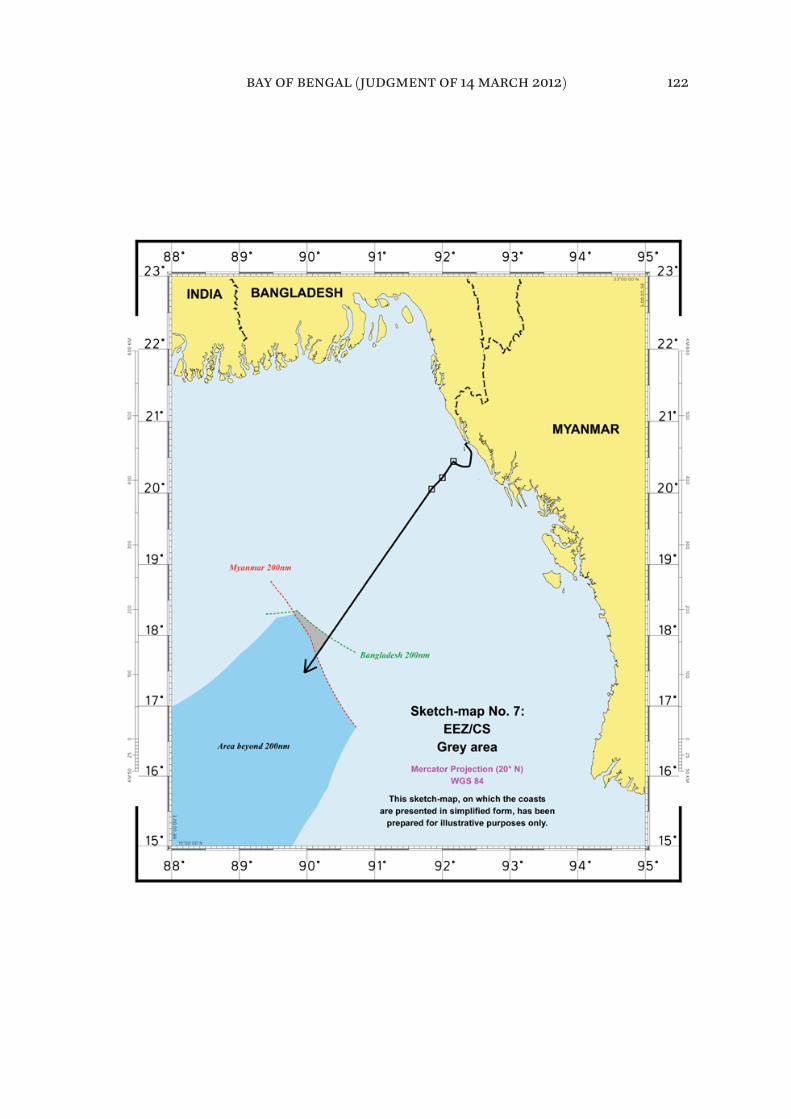
bay of bengal (judgment of 14 march 2012) 122
X. Disproportionality test
477. Having reached the third stage in the delimitation process as referred to in paragraph 240, the Tribunal will, for this purpose, fijirst determine the relevant area, namely the area of overlapping entitlements of the Parties that is relevant to this delimitation. The Tribunal notes in this regard that mathematical preci-sion is not required in the calculation of either the relevant coasts or the rele-vant area.
478. Bangladesh maintains that the relevant area includes the maritime space “situated in the coastal fronts [of the two Parties] and extending out to the 200 [nm]”.
479. Bangladesh recalls that its model of the relevant area does not include maritime spaces landward of the Parties’ coastal façades but notes that even if those areas were included they would not make a material diffference to the proportionality calculation.
480. In determining the relevant area, Bangladesh excludes the areas claimed by third States. According to Bangladesh, “[i]t cannot be right to credit Bangladesh for maritime spaces that are subject to an active claim by a third State”. Bangladesh cautions that “[t]o include those areas in the proportionality calculations would have a dramatic efffect on the numbers that distorts reality”. Bangladesh therefore submits that areas on the “Indian side” of India’s claim are not relevant in the present case.
481. Bangladesh submits that “it is not appropriate to treat as relevant the mar-itime areas lying offf Myanmar’s coast between Bhifff Cape and Cape Negrais. [. . .] It would be incongruous to consider as relevant the maritime spaces adja-cent to an irrelevant coast”.
482. According to Bangladesh, the relevant area measures 175,326.8 square kilo-metres. On the basis of a diffferent calculation of the length of the coasts, Bangladesh also indicated the fijigure of 252,500 square kilometres.
483. Myanmar asserts that the relevant maritime area is dependent on the rel-evant coasts and the projections of these coasts, insofar as they overlap. It describes the relevant area as follows:
bay of bengal (judgment of 14 march 2012) 123

(i) to the north and to the east, it includes all maritime projections from Bangladesh’s relevant coasts, except the area where Bangladesh coasts face each other (the triangle between the second and the third segments);
(ii) to the east and to the south, it includes all maritime projections from Myanmar’s Rakhine (Arakan) coast, as far as these projections overlap with Bangladesh’s;
(iii) to the west, it extends these maritime projections up to the point they overlap.
484. Myanmar submits that Bangladesh has incorrectly portrayed the relevant area. It asserts that in fact “the relevant area consists of the maritime area gener-ated by the projections of Bangladesh’s relevant coasts and Myanmar’s relevant coast”.
485. Myanmar states that there are two issues in relation to which the Parties are not in agreement. One of these issues concerns the exact extent of the rel-evant area on the Indian side of India’s claim. The other issue concerns the relevance of the southern part of the coast of Rakhine.
486. Myanmar disagrees with Bangladesh’s contention that the areas on the Indian side of India’s claim are not relevant in the present case. According to Myanmar, Bangladesh, in not including these areas, not only excluded a mari-time area of more than 11,000 square kilometres, but also made the delimitation between Bangladesh and Myanmar dependent on the claims of a third State, claims that are – according to Bangladesh – changing and in no way established in law or in fact. For this reason, Myanmar is of the view that these areas should be included in the relevant area up to the equidistance line between the coasts of Bangladesh and India.
487. Concerning the southern part of the coast of Rakhine, Myanmar argues that Bangladesh also fails to take into account the south coast of Myanmar which extending all the way to Cape Negrais. Myanmar submits that “this part of the coast is relevant. Its projection overlaps with the projection of the coast of Bangladesh”.
bay of bengal (judgment of 14 march 2012) 124
488. Myanmar submits that the relevant area has a “total surface of 236,539 square kilometres”. During the hearing, however, Myanmar referred to the fijigure of approximately 214,300 square kilometres.
* * *489. The Tribunal notes that the relevant maritime area for the purpose of the delimitation of the exclusive economic zone and the continental shelf between Bangladesh and Myanmar is that resulting from the projections of the relevant coasts of the Parties.
490. The Tribunal recalls that the Parties disagree on two points insofar as the determination of the relevant maritime area is concerned. First, the Parties dis-agree as to the inclusion of the southerly maritime area related to the southern part of the coast of Rakhine which extends to Cape Negrais and, second, they also disagree on the exact extent of the relevant area in the north-west section.
491. Regarding the fijirst issue, the Tribunal recalls that it has already found that the segment of Myanmar’s coast that runs from Bhifff Cape to Cape Negrais is to be included in the calculation of the relevant coast. Therefore, the southern maritime area extending to Cape Negrais must be included in the calculation of the relevant area for the purpose of the test of disproportionality. The southern limit of the relevant area will be marked by the parallel westward from Cape Negrais.
492. Turning to the north-west section of the maritime area which falls within the overlapping area, the Tribunal fijinds that it should be included in the rele-vant area for the purpose of the test of disproportionality.
493. In this regard, the Tribunal considers that, for the purpose of determining any disproportionality in respect of areas allocated to the Parties, the relevant area should include maritime areas subject to overlapping entitlements of the Parties to the present case.
494. The fact that a third party may claim the same maritime area does not prevent its inclusion in the relevant maritime area for purposes of the dispro-portionality test. This in no way afffects the rights of third parties.
bay of bengal (judgment of 14 march 2012) 125

495. For the purposes of the determination of the relevant area, the Tribunal decides that the western limit of the relevant area is marked by a straight line drawn from point ß2 due south.
496. Accordingly, the size of the relevant area has been calculated to be approx-imately 283,471 square kilometres.
497. The Tribunal will now check whether the adjusted equidistance line has caused a signifijicant disproportion by reference to the ratio of the length of the coastlines of the Parties and the ratio of the relevant maritime area allocated to each Party.
498. The length of the relevant coast of Bangladesh, as indicated in paragraph 202, is 413 kilometres, while that of Myanmar, as indicated in paragraph 204, is 587 kilometres. The ratio of the length of the relevant coasts of the Parties is 1:1.42 in favour of Myanmar.
499. The Tribunal notes that its adjusted delimitation line (see paragraphs 337-340) allocates approximately 111,631 square kilometres of the relevant area to Bangladesh and approximately 171,832 square kilometres to Myanmar. The ratio of the allocated areas is approximately 1:1.54 in favour of Myanmar. The Tribunal fijinds that this ratio does not lead to any signifijicant disproportion in the alloca-tion of maritime areas to the Parties relative to the respective lengths of their coasts that would require the shifting of the adjusted equidistance line in order to ensure an equitable solution.
bay of bengal (judgment of 14 march 2012) 126
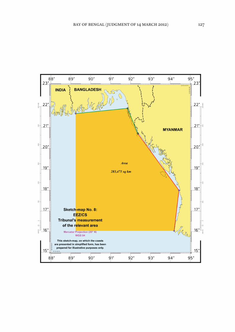
bay of bengal (judgment of 14 march 2012) 127
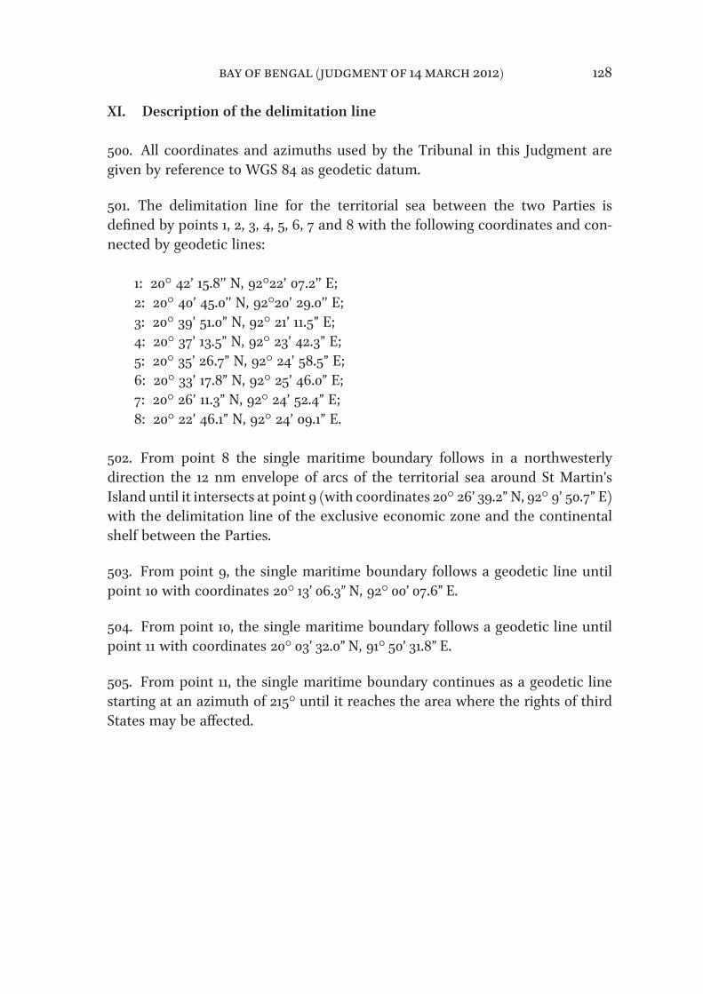
XI. Description of the delimitation line
500. All coordinates and azimuths used by the Tribunal in this Judgment are given by reference to WGS 84 as geodetic datum.
501. The delimitation line for the territorial sea between the two Parties is defijined by points 1, 2, 3, 4, 5, 6, 7 and 8 with the following coordinates and con-nected by geodetic lines:
1: 20° 42’ 15.8’’ N, 92°22’ 07.2’’ E;2: 20° 40’ 45.0’’ N, 92°20’ 29.0’’ E;3: 20° 39’ 51.0” N, 92° 21’ 11.5” E;4: 20° 37’ 13.5” N, 92° 23’ 42.3” E;5: 20° 35’ 26.7” N, 92° 24’ 58.5” E;6: 20° 33’ 17.8” N, 92° 25’ 46.0” E;7: 20° 26’ 11.3” N, 92° 24’ 52.4” E;8: 20° 22’ 46.1” N, 92° 24’ 09.1” E.
502. From point 8 the single maritime boundary follows in a northwesterly direction the 12 nm envelope of arcs of the territorial sea around St Martin’s Island until it intersects at point 9 (with coordinates 20° 26’ 39.2” N, 92° 9’ 50.7” E) with the delimitation line of the exclusive economic zone and the continental shelf between the Parties.
503. From point 9, the single maritime boundary follows a geodetic line until point 10 with coordinates 20° 13’ 06.3” N, 92° 00’ 07.6” E.
504. From point 10, the single maritime boundary follows a geodetic line until point 11 with coordinates 20° 03’ 32.0” N, 91° 50’ 31.8” E.
505. From point 11, the single maritime boundary continues as a geodetic line starting at an azimuth of 215° until it reaches the area where the rights of third States may be afffected.
bay of bengal (judgment of 14 march 2012) 128
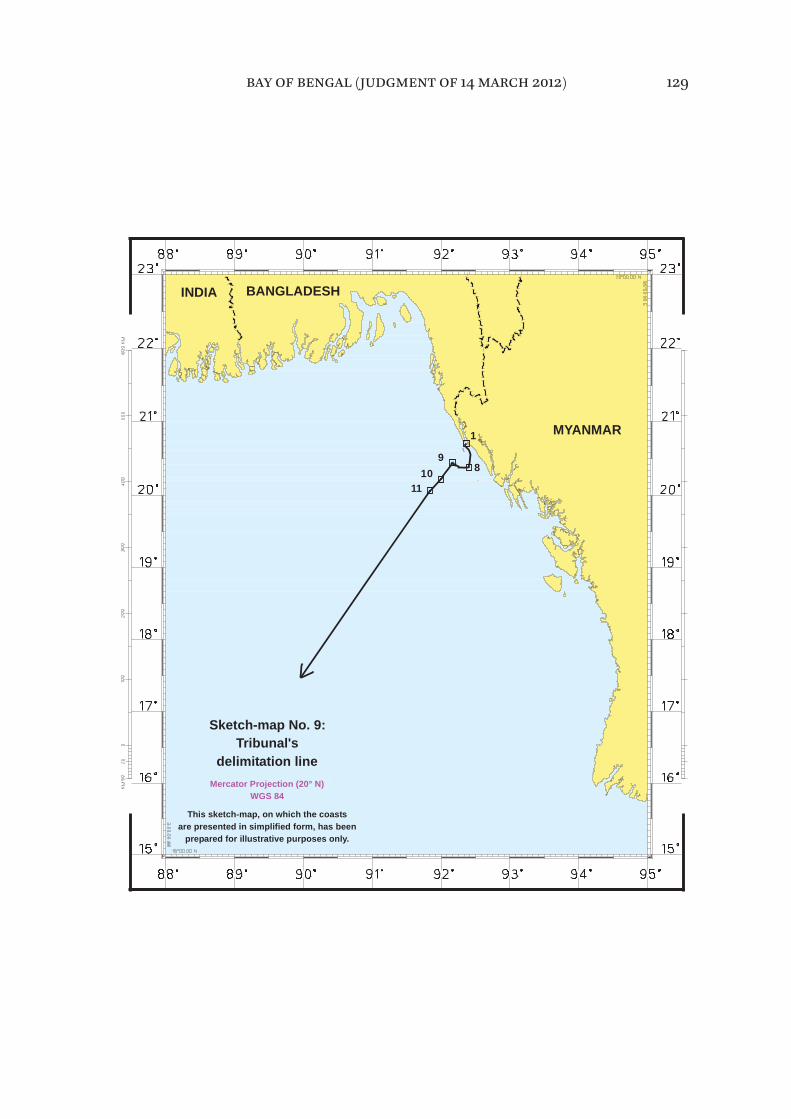
WGS 84
Sketch-map No. 9:
delimitation line
are presented in simplified form, has beenThis sketch-map, on which the coasts
Mercator Projection (20° N)
Tribunal's
prepared for illustrative purposes only.
MYANMAR
910
11
1
8
INDIA BANGLADESH
bay of bengal (judgment of 14 march 2012) 129
XII. Operative clauses
506. For these reasons,
THE TRIBUNAL,
(1) Unanimously,
Finds that it has jurisdiction to delimit the maritime boundary of the territorial sea, the exclusive economic zone and the continental shelf between the Parties.
(2) By 21 votes to 1,
Finds that its jurisdiction concerning the continental shelf includes the delimita-tion of the continental shelf beyond 200 nm;
FOR: President JESUS; Vice-President TÜRK; Judges MAROTTA RANGEL, YANKOV, NELSON, CHANDRASEKHARA RAO, AKL, WOLFRUM, TREVES, COT, LUCKY, PAWLAK, YANAI, KATEKA, HOFFMANN, GAO, BOUGUETAIA, GOLITSYN, PAIK; Judges ad hoc MENSAH, OXMAN;
AGAINST: Judge NDIAYE.
(3) By 20 votes to 2,
Finds that there is no agreement between the Parties within the meaning of article 15 of the Convention concerning the delimitation of the territorial sea;
FOR: President JESUS; Vice-President TÜRK; Judges MAROTTA RANGEL, YANKOV, NELSON, CHANDRASEKHARA RAO, AKL, WOLFRUM, TREVES, NDIAYE, COT, PAWLAK, YANAI, KATEKA, HOFFMANN, GAO, GOLITSYN, PAIK; Judges ad hoc MENSAH, OXMAN;
AGAINST: Judges LUCKY, BOUGUETAIA.
bay of bengal (judgment of 14 march 2012) 130
(4) By 21 votes to 1,
Decides that starting from point 1, with the coordinates 20° 42’ 15.8” N, 92° 22’ 07.2” E in WGS 84 as geodetic datum, as agreed by the Parties in 1966, the line of the single maritime boundary shall follow a geodetic line until it reaches point 2 with the coordinates 20° 40’ 45.0” N, 92° 20’ 29.0” E. From point 2 the single maritime boundary shall follow the median line formed by segments of geodetic lines connecting the points of equidistance between St. Martin’s Island and Myanmar through point 8 with the coordinates 20° 22’ 46.1” N, 92° 24’ 09.1” E. From point 8 the single maritime boundary follows in a northwesterly direction the 12 nm envelope of arcs of the territorial sea around St Martin’s Island until it intersects at point 9 (with the coordinates 20° 26’ 39.2” N, 92° 9’ 50.7” E) with the delimitation line of the exclusive economic zone and continental shelf between the Parties;
FOR: President JESUS; Vice-President TÜRK; Judges MAROTTA RANGEL, YANKOV, NELSON, CHANDRASEKHARA RAO, AKL, WOLFRUM, TREVES, NDIAYE, COT, PAWLAK, YANAI, KATEKA, HOFFMANN, GAO, BOUGUETAIA, GOLITSYN, PAIK; Judges ad hoc MENSAH, OXMAN;
AGAINST: Judge LUCKY.
(5) By 21 votes to 1,
Decides that, from point 9 the single maritime boundary follows a geodetic line until point 10 with the coordinates 20° 13’ 06.3” N, 92° 00’ 07.6” E and then along another geodetic line until point 11 with the coordinates 20° 03’ 32.0” N, 91° 50’ 31.8” E. From point 11 the single maritime boundary continues as a geo-detic line starting at an azimuth of 215° until it reaches the 200 nm limit calcu-lated from the baselines from which the breadth of the territorial sea of Bangladesh is measured;
FOR: President JESUS; Vice-President TÜRK; Judges MAROTTA RANGEL, YANKOV, NELSON, CHANDRASEKHARA RAO, AKL, WOLFRUM, TREVES, NDIAYE, COT, PAWLAK, YANAI, KATEKA, HOFFMANN, GAO, BOUGUETAIA, GOLITSYN, PAIK; Judges ad hoc MENSAH, OXMAN;
AGAINST: Judge LUCKY.
bay of bengal (judgment of 14 march 2012) 131
(6) By 19 votes to 3,
Decides that, beyond that 200 nm limit, the maritime boundary shall continue, along the geodetic line starting from point 11 at an azimuth of 215° as identifijied in operative paragraph 5, until it reaches the area where the rights of third States may be afffected.
FOR: President JESUS; Vice-President TÜRK; Judges MAROTTA RANGEL, YANKOV, NELSON, CHANDRASEKHARA RAO, AKL, WOLFRUM, TREVES, COT, PAWLAK, YANAI, KATEKA, HOFFMANN, BOUGUE-TAIA, GOLITSYN, PAIK; Judges ad hoc MENSAH, OXMAN;
AGAINST: Judges NDIAYE, LUCKY, GAO.
Done in English and in French, both texts being equally authoritative, in the Free and Hanseatic City of Hamburg, this fourteenth day of March, two thou-sand and twelve, in three copies, one of which will be placed in the archives of the Tribunal and the others transmitted to the Government of the People’s Republic of Bangladesh and the Government of the Republic of the Union of Myanmar, respectively.
(signed) José Luís JesusPresident
(signed) Philippe GautierRegistrar
Judges NELSON, CHANDRASEKHARA RAO and COT, availing themselves of the right conferred on them by article 125, paragraph 2, of the Rules of the Tribunal, append their joint declaration to the Judgment of the Tribunal.
(initialled) L.D.M.N.(initialled) P.C.R.(initialled) J.-P.C.
Judge WOLFRUM, availing himself of the right conferred on him by arti-cle 125, paragraph 2, of the Rules of the Tribunal, appends his declaration to the Judgment of the Tribunal.
(initialled) R.W.
bay of bengal (judgment of 14 march 2012) 132

Judge TREVES, availing himself of the right conferred on him by article 125, paragraph 2, of the Rules of the Tribunal, appends his declaration to the Judgment of the Tribunal.
(initialled) T.T.
Judges ad hoc MENSAH and OXMAN, availing themselves of the right con-ferred on them by article 125, paragraph 2, of the Rules of the Tribunal, append their joint declaration to the Judgment of the Tribunal.
(initialled) T.A.M.(initialled) B.H.O.
Judge NDIAYE, availing himself of the right conferred on him by article 30, paragraph 3, of the Statute of the Tribunal, appends his separate opinion to the Judgment of the Tribunal.
(initialled) T.M.N.
Judge COT, availing himself of the right conferred on him by article 30, para-graph 3, of the Statute of the Tribunal, appends his separate opinion to the Judgment of the Tribunal.
(initialled) J.-P.C.
Judge GAO, availing himself of the right conferred on him by article 30, para-graph 3, of the Statute of the Tribunal, appends his separate opinion to the Judgment of the Tribunal.
(initialled) Z.G.
Judge LUCKY, availing himself of the right conferred on him by article 30, paragraph 3, of the Statute of the Tribunal, appends his dissenting opinion to the Judgment of the Tribunal.
(initialled) A.A.L.
bay of bengal (judgment of 14 march 2012) 133