2012 roms user workshop - myroms.org · 2012 roms user workshop ... forte de copacabana: ... the...
TRANSCRIPT

2012 ROMS User WorkshopWindsor Atlântica Hotel, Rio de Janeiro, Brazil
October 22 - 25, 2012
Organized by: Hernan G. Arango, John L. Wilkin, Andrew M. Moore, Maurício da Rocha Fragoso, Carlos E. P. Teixeira, Douglas F. M. Gherardi, Luciano Ponzi Pezzi
ROMSReg
ional Ocean Modeling System
Research Community
http://www.myroms.org/brazil_workshop
ROMSWorkshop

The organizers would like to thank our generous sponsors:

3
Getting to the WorkshopThe workshop is on the third floor of the Windsor Atlântica Hotel near the east end of Copacabana beach. The workshop will be held in the Petrópolis conference room (map 2) on the third floor.
Windsor Atlântica HotelWalking:
The workshop is right next to the beach near the eastern end of Copacabana. The furthest Copacabana hotel is a 40 minute walk along the beach from the workshop. As the tallest building in Copacabana you should have no trouble locating the Windsor Atlântica while walking along the beach.
Via Taxi:Taxi is probably the best way to get from your hotel to the workshop. Avoid taking taxis that don’t have a company name written on them. Your best bet is probably to ask your hotel front desk to arrange a cab for you. The workshop is at the Windsor Atlântica hotel, the address is Avenida Atlântica, 1020 - Copacabana.
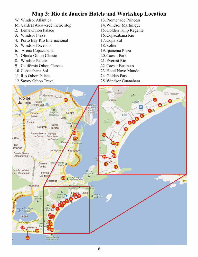
Via Metro (subway):Map 1 shows the subway stations and general location. More precise locations of the metro stations can be found with Google maps. Metro stops are marked with a . The closest metro stop to the workshop is Cardeal Arcoverde (marked on map 3) which is a 10-15 minute walk from the workshop.
Via Bus:If your hotel is in Copacabana the following bus routes (among others) will stop near the workshop location: 318, 332, 336, 593, 591, 523, 2017. If you are catching the bus on Avenida Atlântica, there are no real bus stops so you’ll need to flag down the bus to get them to pick you up. All other streets in Copacabana have marked stops. If you are staying in Flemengo, Botafogo, or downtown, you can take routes 177, 190, 120, 472, 308. Further bus information can be found at: http://www.vadeonibus.com.br/
M

4
Map 1: Rio de Janeiro Metro Map

5
Map
2: W
inds
or A
tlânt
ica
Hot
el T
hird
Flo
or
6
Map 3: Rio de Janeiro Hotels and Workshop LocationW. Windsor AtlânticaM. Cardeal Arcoverde metro stop
Leme Othon Palace2. Windsor Plaza3. Porto Bay Rio Internacional4. Windsor Excelsior5. Arena Copacabana6. Olinda Othon Classic7. Windsor Palace8. Califórnia Othon Classic9. Copacabana Sol10. Rio Othon Palace11. Savoy Othon Travel12.
Promenade Princess13. Windsor Martinique14. Golden Tulip Regente15. Copacabana Rio16. Copa Sul17. Sofitel18. Ipanema Plaza19. Caesar Park20. Everest Rio21. Caesar Business22. Hotel Novo Mundo23. Golden Park24. Windsor Guanabara25.
1817
16 1514
13
12 11
10
9
8 76
5
4
3 2W
25
24
23
22
21
20
19 181716
1514
131211
109
8 76
54
3 2WM
M
7
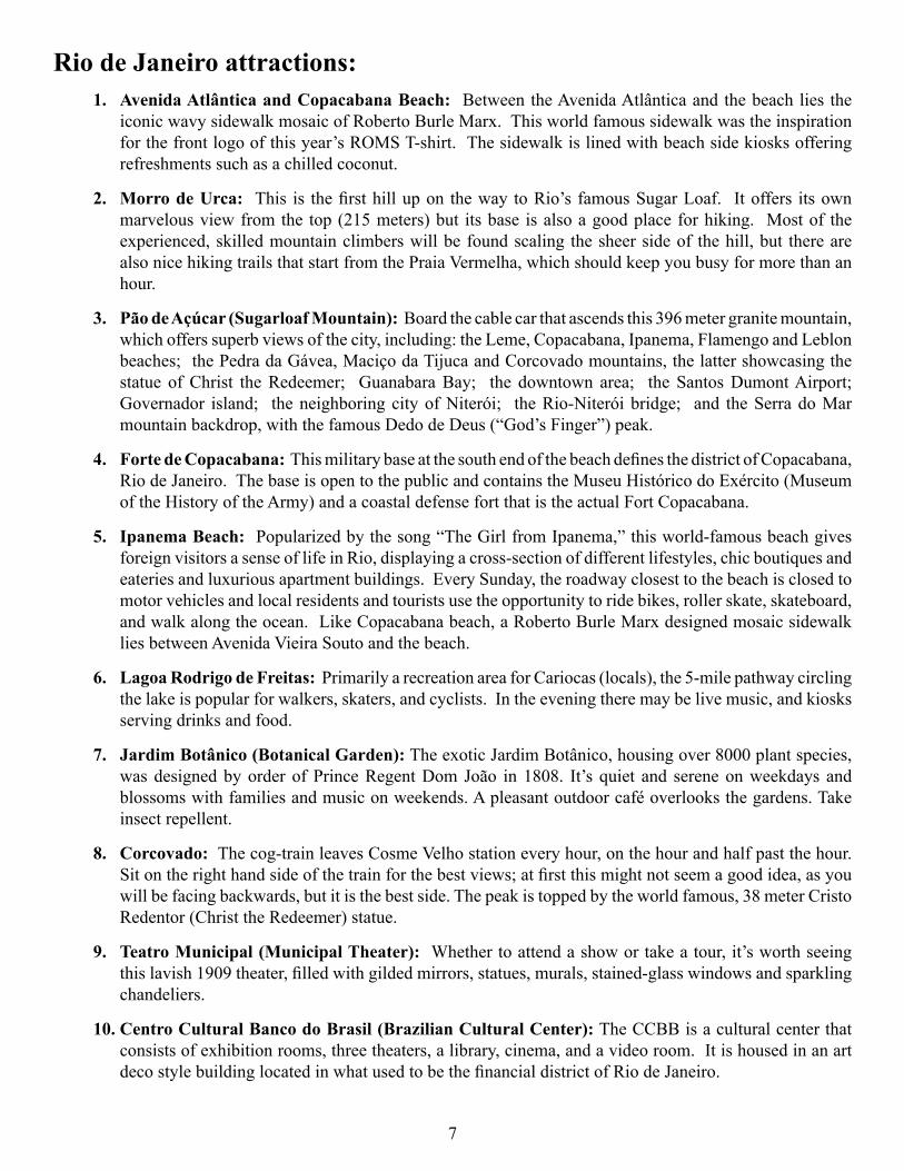
Rio de Janeiro attractions:Avenida Atlântica and Copacabana Beach: 1. Between the Avenida Atlântica and the beach lies the iconic wavy sidewalk mosaic of Roberto Burle Marx. This world famous sidewalk was the inspiration for the front logo of this year’s ROMS T-shirt. The sidewalk is lined with beach side kiosks offering refreshments such as a chilled coconut.
Morro de Urca:2. This is the first hill up on the way to Rio’s famous Sugar Loaf. It offers its own marvelous view from the top (215 meters) but its base is also a good place for hiking. Most of the experienced, skilled mountain climbers will be found scaling the sheer side of the hill, but there are also nice hiking trails that start from the Praia Vermelha, which should keep you busy for more than an hour.
Pão de Açúcar (Sugarloaf Mountain):3. Board the cable car that ascends this 396 meter granite mountain, which offers superb views of the city, including: the Leme, Copacabana, Ipanema, Flamengo and Leblon beaches; the Pedra da Gávea, Maciço da Tijuca and Corcovado mountains, the latter showcasing the statue of Christ the Redeemer; Guanabara Bay; the downtown area; the Santos Dumont Airport; Governador island; the neighboring city of Niterói; the Rio-Niterói bridge; and the Serra do Mar mountain backdrop, with the famous Dedo de Deus (“God’s Finger”) peak.
Forte de Copacabana:4. This military base at the south end of the beach defines the district of Copacabana, Rio de Janeiro. The base is open to the public and contains the Museu Histórico do Exército (Museum of the History of the Army) and a coastal defense fort that is the actual Fort Copacabana.
Ipanema Beach: 5. Popularized by the song “The Girl from Ipanema,” this world-famous beach gives foreign visitors a sense of life in Rio, displaying a cross-section of different lifestyles, chic boutiques and eateries and luxurious apartment buildings. Every Sunday, the roadway closest to the beach is closed to motor vehicles and local residents and tourists use the opportunity to ride bikes, roller skate, skateboard, and walk along the ocean. Like Copacabana beach, a Roberto Burle Marx designed mosaic sidewalk lies between Avenida Vieira Souto and the beach.
Lagoa Rodrigo de Freitas:6. Primarily a recreation area for Cariocas (locals), the 5-mile pathway circling the lake is popular for walkers, skaters, and cyclists. In the evening there may be live music, and kiosks serving drinks and food.
Jardim Botânico (Botanical Garden):7. The exotic Jardim Botânico, housing over 8000 plant species, was designed by order of Prince Regent Dom João in 1808. It’s quiet and serene on weekdays and blossoms with families and music on weekends. A pleasant outdoor café overlooks the gardens. Take insect repellent.
Corcovado:8. The cog-train leaves Cosme Velho station every hour, on the hour and half past the hour. Sit on the right hand side of the train for the best views; at first this might not seem a good idea, as you will be facing backwards, but it is the best side. The peak is topped by the world famous, 38 meter Cristo Redentor (Christ the Redeemer) statue.
Teatro Municipal (Municipal Theater):9. Whether to attend a show or take a tour, it’s worth seeing this lavish 1909 theater, filled with gilded mirrors, statues, murals, stained-glass windows and sparkling chandeliers.
Centro Cultural Banco do Brasil (Brazilian Cultural Center):10. The CCBB is a cultural center that consists of exhibition rooms, three theaters, a library, cinema, and a video room. It is housed in an art deco style building located in what used to be the financial district of Rio de Janeiro.

8
Map 4: Rio de Janeiro Tourist Attractions
10
9
8
7
6
5 4
32
1

9
W
M
There will be a reception cruise on Tuesday, October 23rd, 2012. Transportation, via bus, between the workshop and marina will be provided. We suggest you bring appropriate attire for a day and night cruise. The average temperature this time of year in Rio is between 21°C (70°F) and 27°C (80°F). We will be leaving the Windsor Atlântica at 16:30 and arriving at Marina da Glória at 17:00. From the marina the boat will take a tour around Guanabara Bay passing the Naval Academy, Fiscal Island, Rio/Niterói Bridge, Niterói, Icaraí, São Francisco, and returning to Marina da Glória around 21:30. Onboard we will have drinks (beer, caipirinhas, soda, juice) and finger foods. The food and drink will be simple, but it´s about the ambience, the experience, and the fantastic views! We will have 2 hours of daylight and a beautiful sunset. We can mingle, take pictures and have some (lots!) of caipirinhas. There will also be music. Once we arrive back at Marina da Glória, we will re-board the busses back to the Windsor Atlântica. If people are still hungry, there are plenty of options for dinner near the Windsor Atlântica.
Cruise Reception Information

10
Name Affiliation E-mail1 Aguirre, Enrique INPE/CPTEC/DMD/LAC, Brazil [email protected] Alves, Fernando PETROBRAS, Brasil [email protected]
3 Amaral Ramos, Arthur Eduardo Centro de Hidrografia da Marinha, Brasil [email protected]
4 Andrioni, Marcelo PETROBRAS, Brasil [email protected] 5 Arango, Hernan G. IMCS, Rutgers University, USA [email protected] Assad, Luiz Paulo COPPE/UFRJ, Rio de Janeiro - RJ, Brasil [email protected] Bastos de Oliveira, Hugo FURG, Rio Grande - RS, Brasil [email protected] Boechat, Ana PROOCEANO, Brasil [email protected] Bonow Munchow, Gabriel UFRGS, Porto Alegre - RS, Brasil [email protected]
10 Cahill, Bronwyn Informus GmbH, Germany [email protected] Calado, Leandro Brazilian Navy - IEAPM, Brasil [email protected] Calil, Paulo FURG, Rio Grande - RS, Brasil [email protected] Candella, Rogerio Brazilian Navy - IEAPM, Brasil [email protected] Capet, Xavier LOCEAN - CNRS, France [email protected] Carvalho, Gabriel PROOCEANO, Brasil [email protected] de Carvalho, Jéssica IOUSP, Sao Paulo, Brasil [email protected] Cevolani, Karina UFES, Vitória - ES, Brasil [email protected] 18 Chamorro, Andrés University of Puerto Rico RUM, Puerto Rico [email protected] Cirano, Mauro UFBA, Salvador - Bahia, Brasil [email protected] Codato, Gabriel IEAPM, Brazilian Navy, Brasil [email protected] Colberg, Frank CSIRO, Australia [email protected] Correa, David MSDCORREA, Perú [email protected] Cotrim da Cunha, Leticia UERJ, Rio de Janeiro - RJ, Brasil [email protected] Cruz, Lilian UFBA, Salvador - Bahia, Brasil [email protected] Demange, Jérémie INRIA / LJK, France [email protected] Dias, Fabio FURG, Rio Grande - RS, Brasil [email protected] Etienne, Helene CLS, France [email protected] Faggiani Dias, Daniela INPE, Brasil [email protected] Farley Nicholls, James Imperial College, UK [email protected] Feddersen, Falk Scripps Institution of Oceanography, USA [email protected] Fernandes, Alexandre UERJ, Rio de Janeiro - RJ, Brasil [email protected] Fiadeiro, Manuel Office of Naval Research (ONR), USA [email protected] Fleming, Naomi IMCS, Rutgers University, Brasil [email protected] Fragoso, Mauricio PROOCEANO, Brasil [email protected] Freitas, Ana Centro de Hidrografia da Marinha, Brasil [email protected] Garção, Henery PROOCEANO, Brasil [email protected] Gherardi, Douglas INPE, Brasil [email protected] Ghisolfi, Renato UFES, Vitória - ES, Brasil [email protected] Glenn, Scott IMCS, Rutgers University, USA [email protected] Godoi, Victor Brazilian Navy - IEAPM, Brasil [email protected] Gomes dos Santos, Natalia PROOCEANO, Brasil [email protected] He, Ruoying North Carolina State University, USA [email protected] Hetland, Robert Texas A&M University, USA [email protected] Kim, Chang S. Korea Ocean R&D Institute, South Korea [email protected]
Participants
11
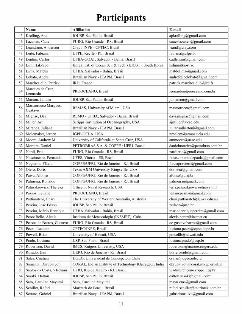
Name Affiliation E-mail45 Krelling, Ana IOUSP, Sao Paulo, Brasil [email protected] Lazaneo, Caue FURG, Rio Grande - RS, Brasil [email protected] Leandrine, Anderson Cray / INPE - CPTEC, Brasil [email protected] Leite, Fabiana UFPE, Recife - PE, Brasil [email protected] Lentini, Carlos UFBA-GOAT, Salvador - Bahia, Brasil [email protected] Lim, Hak-Soo Korea Inst. of Ocean Sci. & Tech. (KIOST), South Korea [email protected] Lima, Mateus UFBA, Salvador - Bahia, Brasil [email protected] Lobato, Andre Brazilian Navy - IEAPM, Brasil [email protected] Marchesiello, Patrick IRD, France [email protected]
54 Marques da Cruz, Leonardo PROOCEANO, Brasil [email protected]
55 Marson, Juliana IOUSP, Sao Paulo, Brasil [email protected]
56 Mastrorocco Marques, Gustavo RSMAS, University of Miami, USA [email protected]
57 Mignac, Davi REMO - UFBA, Salvador - Bahia, Brasil [email protected] Miller, Art Scripps Institution of Oceanography, USA [email protected] Miranda, Juliana Brazilian Navy - IEAPM, Brasil [email protected] Molemaker, Jeroen IGPP-UCLA, USA [email protected] Moore, Andrew M. University of California at Santa Cruz, USA [email protected] 62 Moreira, Daniel PETROBRAS S.A. & COPPE / UFRJ, Brasil [email protected] Nardi, Eric FURG, Rio Grande - RS, Brasil [email protected] Nascimento, Fernanda UFES, Vitória - ES, Brasil [email protected] Nogueira, Flávia COPPE/UFRJ, Rio de Janeiro - RJ, Brasil [email protected] Otero, Doris Texas A&M University-Kingsville, USA [email protected] Paiva, Afonso COPPE/UFRJ, Rio de Janeiro - RJ, Brasil [email protected] Palmeira, Ronaldo COPPE/UFRJ, Rio de Janeiro - RJ, Brasil [email protected] Paluszkiewicz, Theresa Office of Naval Research, USA [email protected] Passos, Leilane PROOCEANO, Brasil [email protected] Pattiaratchi, Chari The University of Western Australia, Australia [email protected] Pereira, Jose Edson IOUSP, Sao Paulo, Brasil [email protected] Pereira, Mário Henrique UFBA, Salvador - Bahia, Brasil [email protected] Perez Bello, Alexis Instituto de Meteorologia (INSMET), Cuba [email protected] Pessoa de Barros, Gustavo FURG, Rio Grande - RS, Brasil [email protected] Pezzi, Luciano CPTEC/INPE, Brasil [email protected] Powell, Brian University of Hawaii, USA [email protected] Prado, Luciana USP, Sao Paulo, Brasil [email protected] Robertson, David IMCS, Rutgers University, USA [email protected] Rosado, Dan UERJ, Rio de Janeiro - RJ, Brasil [email protected] Salas, Cristian DGEO, Universidad de Concepcion, Chile [email protected] Samanta, Dhrubajyoti CORAL, Indian Institute of Technology Kharagpur, India [email protected] Santos da Costa, Vladimir UFRJ, Rio de Janeiro - RJ, Brasil [email protected] Sasaki, Dalton IOUSP, Sao Paulo, Brasil [email protected] Sato, Carolina Mayumi Sato, Carolina Mayumi [email protected] Schiller, Rafael Marintek do Brasil, Brasil [email protected] Serrato, Gabriel Brazilian Navy - IEAPM, Brasil [email protected]
Participants

12
ParticipantsName Affiliation E-mail
88 Servino, Ricardo UFES, Brasil [email protected] Silva, Marcus UFPE, Recife - PE, Brasil [email protected] Soares, Felipe PROOCEANO, Brasil [email protected] Soares, Helena INPE, Brasil [email protected] Soares, Kayo Cezar Atlantis, Brasil [email protected] Soutelino, Rafael Brazilian Navy - IEAPM, Brasil [email protected] Souza, Joao Marcos SOEST, USA [email protected] Takanaca de Decco, Hatsue COPPE/UFRJ, Rio de Janeiro - RJ, Brasil [email protected] Tamaoki, Jonas Cray, Brasil [email protected] Tanajura, Clemente UFBA, Salvador - Bahia, Brasil [email protected] Teixeira, Carlos LabomarUFC, Brasil [email protected] Torres Jr, Audalio Rebelo UFRJ, Rio de Janeiro - RJ, Brasil [email protected]
100 Wilkin, John IMCS, Rutgers University, USA [email protected] Yannicelli, Beatriz CEAZA, Chile [email protected] Zhang, Xiaoqian Texas A&M University, USA [email protected]

PROGRAM
13
---------- Monday, October 22, 2012 AM ----------
08:00-08:50 Registration
08:50-09:00 Welcome and Logistics
Chairperson: Mauricio Fragoso
09:00-09:40(40 min)
Ruoying He, North Carolina State U., USAAn integrated Ocean Circulation, Wave, Atmosphere and Marine Ecosystem Prediction System for the South Atlantic Bight and Gulf of Mexico
09:40-10:10(30 min)
Jeroen Molemaker, IGPP-UCLA, USA Submesoscale Dynamics in the Wintertime North Western Atlantic
10:10-10:30 Break (20 min)
Chairperson: Arthur Miller
10:30-11:00(30 min)
Xavier Capet, LOCEAN - CNRS, FranceFine-scale turbulent processes: mesoscale stirring and submesoscale instabilities
11:00-11:30(30 min)
James Farley Nicholls, Imperial College, UK Inertial currents in the Caspian Sea
11:30-12:00 (30 min)
Gustavo Mastrorocco Marques, RSMAS, USA On modeling the turbulent exchange in buoyancy-driven fronts
12:00-15:00 Lunch Break
---------- Monday, October 22, 2012 PM ----------
Chairperson: Douglas Gherardi
15:00-15:30(30 min)
Art Miller, Scripps Inst. of Oceanography, USAIsolating Mesoscale Coupled Ocean-Atmosphere Interactions in the Kuroshio Extension Region
15:30-16:00(30 min)
Joao Marcos Souza, SOEST, U. of Hawaii, USA Hawaiian Islands Operational System
16:00-16:30(30 min)
Carlos Teixeira, Labomar UFC, Brasil Dynamics of Spencer Gulf: Effects of Evaporation, Heating and Tides
16:30-17:00 (30 min)
Hak-Soo Lim, KIOST, South Korea Operational coastal modeling for the coastal waters of Korea using ROMS
17:00-18:00 Poster Session 1
2012 ROMS User Workshop

PROGRAM
14
---------- Tuesday, October 23, 2012 AM ----------
Chairperson: Hernan G. Arango
09:00-09:40(40 min)
Andrew M. Moore, UC Santa Cruz, USACharacterization of Forecast Error using Singular Value Decomposition
09:40-10:10(30 min)
Brian Powell, University of Hawaii Manoa, USA Combining a Model with Observations: Data Assimilation in ROMS
10:10-10:30 Break (20 min)
Chairperson: Charitha Pattiaratchi
10:30-11:00(30 min)
Frank Colberg, CSIRO, AustraliaThe impact of future changes in weather patterns on extreme sea levels over southern Australia
11:00-11:30(30 min)
Robert Hetland, Texas A&M University, USAWind and density driven flow along the Texas-Louisiana continental shelf
11:30-12:00 (30 min)
Xiaoqian Zhang, Texas A&M University, USAA numerical investigation of the Mississippi and Atchafalaya freshwater transport, filling and flushing times on the Texas-Louisiana Shelf
12:00-13:30 Lunch
---------- Tuesday, October 23, 2012 PM ----------
Chairperson: John Wilkin
13:30-14:00(30 min)
Bronwyn Cahill, Informus GmbH, GermanyInterannual Variability of Primary Production and Carbon Fluxes along the U.S. Eastern Continental Shelf: Impact of Atmospheric Forcing?
14:00-14:30(30 min)
Paulo Calil, FURG, Rio Grande - RS, Brasil Biological Relevance of Submesoscale Processes in the Stratified, Oligotrophic Ocean
14:30-15:00(30 min)
Marcus Silva, UFPE, Recife - PE, Brasil Simulating the tropical Atlantic air-sea CO2 exchange with a Regional high resolution ocean modeling system
15:00-15:30 (30 min)
Luciano Pezzi, INPE/CPTEC, Brasil The Regional Ocean Modeling initiatives at INPE: An overview of South Atlantic Ocean modeling and biochemical studies
15:30-16:30 Poster Session 2
17:00-21:30 Cruise Reception
PROGRAM
15
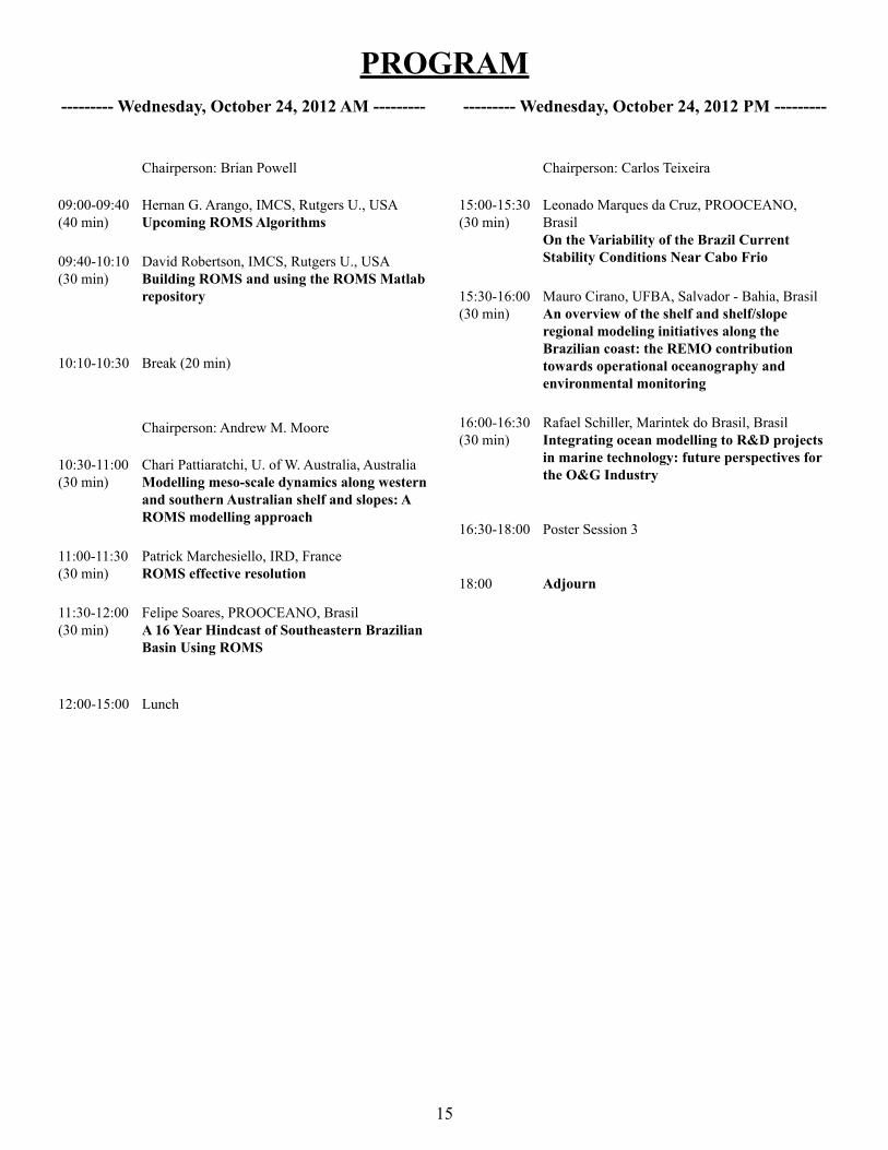
--------- Wednesday, October 24, 2012 AM ---------
Chairperson: Brian Powell
09:00-09:40(40 min)
Hernan G. Arango, IMCS, Rutgers U., USAUpcoming ROMS Algorithms
09:40-10:10(30 min)
David Robertson, IMCS, Rutgers U., USA Building ROMS and using the ROMS Matlab repository
10:10-10:30 Break (20 min)
Chairperson: Andrew M. Moore
10:30-11:00(30 min)
Chari Pattiaratchi, U. of W. Australia, AustraliaModelling meso-scale dynamics along western and southern Australian shelf and slopes: A ROMS modelling approach
11:00-11:30(30 min)
Patrick Marchesiello, IRD, FranceROMS effective resolution
11:30-12:00 (30 min)
Felipe Soares, PROOCEANO, BrasilA 16 Year Hindcast of Southeastern Brazilian Basin Using ROMS
12:00-15:00 Lunch
--------- Wednesday, October 24, 2012 PM ---------
Chairperson: Carlos Teixeira
15:00-15:30(30 min)
Leonado Marques da Cruz, PROOCEANO, BrasilOn the Variability of the Brazil Current Stability Conditions Near Cabo Frio
15:30-16:00(30 min)
Mauro Cirano, UFBA, Salvador - Bahia, BrasilAn overview of the shelf and shelf/slope regional modeling initiatives along the Brazilian coast: the REMO contribution towards operational oceanography and environmental monitoring
16:00-16:30(30 min)
Rafael Schiller, Marintek do Brasil, BrasilIntegrating ocean modelling to R&D projects in marine technology: future perspectives for the O&G Industry
16:30-18:00 Poster Session 3
18:00 Adjourn

PROGRAM
16
---------- Thursday, October 25, 2012 AM----------
Chairperson: Mauricio Fragoso
09:00-09:40(40 min)
Chari Pattiaratchi, U. of W. Australia, AustraliaOcean observations in Western Australia
9:40-10:20 (40 min)
Scott Glenn, IMCS, Rutgers U., USA The Rise of Regional-scale Ocean Observatories for Science, Society and Security in the United States, and the Development of Collaborative Global Networks
10:20-10:40 Break (20 min)
Chairperson: Scott Glenn
10:40-11:20(40 min)
Mauricio Fragoso, PROOCEANO, BrasilSantos Basin Ocean Observing System - Project Blue
11:20-11:50(30 min)
Rogerio Candella, IEAPM, BrasilLong-term oceanographic measurements along the Brazilian coast: Characteristics and Perspectives
11:50-12:20(30 min)
Afonso Paiva, COPPE/UFRJ, BrasilOcean Observation in the Scope of the Ocean Science INCT in Brazil
12:20-14:00 Lunch
---------- Thursday, October 25, 2012 PM----------
Chairperson: John Wilkin
14:00-14:40 (40 min)
Andrew M. Moore, UC Santa Cruz, USA Quantifying the Value of Observations in Ocean State Estimation
14:40-15:20(40 min)
Brian Powell, University of Hawaii Manoa, USAQuantifying real-time observations on model state estimation
15:20-15:40 Break (20 min)
Chairperson: Andrew M. Moore
15:40-16:20(40 min)
John Wilkin, IMCS, Rutgers University, USA An evaluation of real-time forecast models of Middle Atlantic Bight continental shelf waters
16:20-18:00(1 h 40 min) Open Discussion
18:00 Adjourn
Special Session on Modern Observational and Modern Modeling Systems

PROGRAM
17
Marson, Juliana, IOUSP, Sao Paulo, Brasil 13. ROMS and Meltwater Pulses
Moore, Andrew M., U. of California at Santa Cruz, USA 14. An Historical Analysis of the California Current using ROMS 4D-Var: 1980-2010
Nascimento, Fernanda, UFES, Vitória - ES, Brasil 15. A Numerical Study of the Tide and Tidal Dynamics Effects in the Amazon River Plume
Passos, Leilane, PROOCEANO, Brasil 16. Mesoscale baroclinic flow patterns off the Tubarão Bight and Abrolhos Bank
Pereira, Jose Edson, IOUSP, Sao Paulo, Brasil 17. Use of ROMS to downscale ocean climate scenarios - South Atlantic case
Pezzi, Luciano, CPTEC/INPE, Brasil 18. Implementation of a regional model for oceanic climatic studies in Tropical and Western South Atlantic Ocean
Sato, Carolina Mayumi, COPPE/UFRJ and IEAPM/Brazilian 19. Navy, Brasil Seasonal behavior and the plume evolution of the Cabo Frio coastal upwelling, Brazil
Serrato, Gabriel, Brazilian Navy - IEAPM, Brasil 20. The influence of different wind stress forcing on Brazil Current - Eddy - Upwelling System off Cabo Frio (23°S)
Soares, Helena, INPE, Brasil 21. Assessment of climate variability impacts on the Brazilian Large Marine Ecosystems using statistical analysis and regional ocean modeling
Soutelino, Rafael, Brazilian Navy - IEAPM, Brasil 22. On the dynamics of the Brazil Current site of origin
PostersAguirre, Enrique, INPE/CPTEC/DMD/LAC, Brasil 1. Role of meridional component of wind at upwelling along the coast of Brazil
Amaral Ramos, Arthur Eduardo, Centro de Hidrografia da 2. Marinha, Brasil On the formation and evolution of Cabo Frio upwelling
Bastos de Oliveira, Hugo, FURG, Rio Grande - RS, Brasil 3. Results and Validation of The Ocean Circulation around Southeast Brazilian Coast - Towards Ocean Prediction for the Oil Industry
Bonow Munchow, Gabriel, UFRGS, Porto Alegre - RS, 4. Brasil Preliminary results of COAWST modeling system for Rio grande do sul state - Brazil and central region of south Atlantic ocean
Carvalho, Gabriel, PROOCEANO, Brasil 5. Investigation of Wind Influence on The South Equatorial Current Bifurcation Through Numerical Ocean Modeling
Cirano, Mauro, UFBA, Salvador - Bahia, Brasil 6. The seasonal circulation of the Eastern Brazilian Shelf between 10°S and 16°S: a modeling approach
Codato, Gabriel, IEAPM, Brazilian Navy, Brasil 7. Feature-oriented regional modeling and simulations for acoustic prediction in the Cabo Frio upwelling system: forecasting validation
Dias, Fabio, FURG, Rio Grande - RS, Brasil 8. Influence of the South Atlantic Central Water on biological production at the south Brazilian continental shelf
Faggiani Dias, Daniela, INPE, Brasil 9. Modelling physical-biological interactions: preliminary results on the dynamics of the Southeast Brazil Bight using ROMS
Kim, Chang S., Korea Ocean R&D Institute, South Korea 10. Coastal water quality model ROMS-ICM and its application
Krelling, Ana, IOUSP, Sao Paulo, Brasil 11. Mesoscale activity in the North Brazil Undercurrent investigated through model results
Leite, Fabiana, UFPE, Recife - PE, Brasil 12. Coupled physical-biogeochemical modeling of the Southwestern Tropical Atlantic

18
Upcoming ROMS Algorithms
Hernan G. ArangoIMCS, Rutgers University, USA
Andrew M. Moore University of California at Santa Cruz, USA
John C. WarnerU.S. Geological Survey, Woods Hole, MA, USA
An overview of the upcoming ROMS algorithms will be presented. Several new algorithms have been developed and are currently under extensive testing before they are released. These include Phase III (final phase) of multiple grid nesting, a Reduced Preconditioned Conjugate Gradient (RPCG) algorithm for 4D-Var, data assimilation observations quality control, and Objective Analysis (OA) packages for Fortran and Matlab.
Three types of nesting capabilities have been designed and coded in ROMS: (i) refinement grids which provide increased resolution (3:1, 5:1, or 7:1) in a specific region; (ii) mosaics which connect several grids along their edges, and (iii) composite grids which allow overlap regions of aligned and non-aligned grids. The mosaic and composite grid code infrastructures are identical. The differences are geometrical and primarily based on the alignment between adjacent grids. All the mosaic grids are exactly aligned with the adjacent grid. In general, the mosaic grids are a special case of the composite grids.
The nesting development in ROMS was divided into three phases due to its complexity. Phase I included substantial modifications of the numerical kernels to allow a generic treatment of the spatial horizontal operators in the nesting contact regions. Phase II included an overhaul of ROMS lateral boundary conditions to facilitate, in a generic way, their processing or not in applications with nested grids. Phase III included the data managing and time-stepping infrastructure for one or more nesting layers. Phase I was released to the community as ROMS 3.5 on April 25, 2011 whereas Phase II was released as ROMS 3.6 on September 23, 2011. The coding of Phase III has been completed and is currently under extensive testing.
The ROMS nested grid design includes three Super-Classes and several Sub-Classes:
1. Composite Grids Super-Class:
a. Mosaic Grids Sub-Class
b. Composite Overlap Grids Sub-Class
c. Complex Estuary Composite Grids Sub-Class
d. Partial Boundary Composite Grids Sub-Class
2. Refinement Grids Super-Class:
a. Single Refinement Sub-Class
b. Multiple Refinement Sub-Class
Talk Abstracts 3. Composite and Refinement Combination Super-Class:
a. Refinement and Partial Boundary Composite Sub-Class
b. Complex Estuary Refinement-Composite Sub-Class
Hence, there are several possibilities and combinations. The design is flexible enough to allow complex nested grid configurations in coastal applications. An extensive library of Matlab scripts (https://www.myroms.org/wiki/index.php/Matlab_Scripts) was released to process the contact points in the nesting grids contact regions. The information is quite technical but it provides a good guideline for building nested grid applications. The exchange of information is always two-way.
Interannual Variability of Primary Production and Carbon Fluxes along the U.S. Eastern Continental Shelf: Impact of
Atmospheric Forcing?
Bronwyn Cahill Informus GmbH, Berlin, Germany
Katja Fennel
Department of Oceanography, Dalhousie University, Nova Scotia, Canada
John Wilkin
IMCS, Rutgers University, USA
The role of continental shelf systems as a sink or source of atmospheric CO2 in global carbon budgets is an open question. Current thinking suggests that some of the factors influencing shelf ecosystem production include variability in atmospheric forcing. We investigate the impact of interannual variability in atmospheric forcing on shelf production and the capacity of different shelf regions to act as a sink or source of atmospheric CO2. We present results from a biogeochemical model experiment (ROMS-Fennel) along the US East Coast Continental Shelf and compare the shelf response using two model scenarios. The first scenario, referred to as “present day” represents contemporary mesoscale variability in forcing as captured by NARR-NCEP 3-hourly fields from 2004 to 2007. The second scenario, referred to as “future”, adjusts the present day forcing to account for atmospheric anomalies derived from modern and future simulations of a regional climate model, RegCM3, indicative of a doubling of atmospheric CO2. Our present day interannual estimates of primary production agree well with satellite estimates. A clear, along shelf gradient (south to north) in CO2 flux is present. The South Atlantic Bight acts as a small source of CO2 to the atmosphere, and to a lesser extent some coastal areas of the Mid-Atlantic Bight, while the Mid-Atlantic Bight Shelf and Slope waters and the Gulf of Maine act as stronger sinks of atmospheric CO2. The response to “future” perturbations
19
in atmospheric forcing shows interesting changes in regional production estimates. Annual production decreases in the South and Mid Atlantic Bights, while it increases in the Gulf of Maine and regional regime shifts occur in air-sea CO2 fluxes (i.e. from CO2 sink to CO2 source).
Biological Relevance of Submesoscale Processes in the Stratified, Oligotrophic
Ocean
Paulo H. R. Calil Universidade Federal do Rio Grande, Brasil
Yawei Luo, Ivan Lima, Scott C. Doney
Woods Hole Oceanographic Institution, USA
Submesoscale processes have been shown to be important in regions of low stratification and deep mixed layers. We investigate the importance of submesoscale nutrient injections in a region of the North Pacific ocean with shallow mixed layers and high stratification. A simple, nitrogen-based plankton model is embedded in a ROMS configuration for the Hawaiian region centered on Station ALOHA (part of the Hawaii Ocean Time-series, HOT). As the grid resolution is increased, shoaling of the average depth of the nutricline and frequency of episodic nitrate injections are increased due to the larger vertical velocity variance and larger buoyancy variance just below the mixed layer. As a consequence, large phytoplankton species, absent at lower resolutions, emerge. The modeled primary productivity at Station ALOHA is enhanced during these episodic injection events. These results are important in the context of the observed primary productivity patterns. In regions with low surface NO3:PO4 ratios, episodic injections supply an excess of PO4 relative to Redfield stoichiometry. Phosphate is a limiting nutrient for nitrogen-fixing diazotroph growth at Station ALOHA, which may help explain the observed primary productivity pattern.
Long-term oceanographic measurements along the Brazilian coast: Characteristics
and Perspectives
Rogerio CandellaIEAPM - Institute of Sea Research of the Brazilian
Navy, Brasil
Despite some initiatives, there is still a lack of long-term oceanographic measurements along the Brazilian coast, especially freely available data. Basically, only sea level measurements are available in time series long enough to characterize interannual variability. Since 2011, the National Buoys Program (PNBOIA), the Brazilian contribution to the Global Ocean Observation
System (GOOS), has deployed a series of buoys, typically on the 200m isobath, to collect meteorological and oceanographic data. The GLOSS-Brasil (Global Sea Level Observing System) project has improved the quality of the sea level measurements with more stations and more accurate equipment. The Institute of Sea Research of the Brazilian Navy (IEAPM) maintains a tidal station since 1999 and has acquired a meteo-oceanographic buoy that will be launched in the upwelling area near Arraial do Cabo, RJ by the end of this year.
Fine-scale turbulent processes: mesoscale stirring and submesoscale instabilities
Xavier CapetLOCEAN, IPSL, France
Upper ocean frontal turbulence associated with horizontal length scales on the order of 1-10 km has attracted significant attention recently. Its role in the ocean is still being debated but much progress has been made on the mechanisms at work. A series of ROMS experiments in a periodic channel are presented to illustrate two dominant mechanisms: i) surface density stirring by mesoscale eddies and ii) fine scale instabilities directly energizing the submesoscale range. A particular example of the latter is the Charney instability whose possible relevance in the ocean will also be discussed.
An overview of the shelf and shelf/slope regional modeling initiatives along the
Brazilian coast: the REMO contribution towards operational oceanography and
environmental monitoring
Mauro Cirano1, Martinho Marta-Almeida2, Hugo B. de Oliveira3, Janini Pereira1, Fabiola N. de
Amorim2, Ivan D. Soares4, Renato P. Martins5, José A. M. Lima5, and Clemente A. S. Tanajura1
Universidade Federal da Bahia, Brasil1. Universidade de Aveiro, Portugal2. Rede de Modelagem e Observação 3. Oceanográfica, BrasilAtlantis, Brasil4. CENPES/PETROBRAS, Brasil5.
The main goal of REMO (Portuguese acronym for Oceanographic Modeling and Observation Network) is to undertake research and development in physical oceanography, ocean modeling, and operational forecasting with data assimilation. Its primary study

20
area is the South Atlantic Ocean and Brazilian coast regions. REMO uses regional models to focus on particular details of the ocean circulation. For example, the interaction of the Western Boundary Currents and associated meso-scale activities with the tidal and wind-driven circulation on the continental shelf/slope.
In this presentation, we provide an overview of the development of regional applications using ROMS, preliminary results and accomplishments, and our future goals within the REMO project.
The impact of future changes in weather patterns on extreme sea levels over southern
Australia
Frank ColbergCSIRO, Australia
This modeling study investigates the roll of anthropogenic climate change in inducing extreme sea level variability along southern Australia and Tasmania. ROMS is forced by two regionally downscaled CMIP3 climate models and one GCM for current and future climates, respectively. Model results show a reduction in extreme sea levels of about 1-10cm in response to a range of atmospheric forcing for future climates along southern Australia, Tasmania and Bass Strait. Results show a strong seasonality in the response. In austral autumn, a tendency of reduced extreme sea levels is observed in the study area. However, in austral winter, raised mean sea levels along Tasmania are simulated. Changes in maximum sea levels reflect changes in atmospheric conditions. Reduced maximum sea levels in austral spring and summer are associated with enhanced easterly winds near the southern coast and reduced westerlies over the Southern Ocean. In austral winter, enhanced westerlies lead to increased sea levels along Tasmania. Similarly, reduced maximum wind speeds over southern Australia further reduce sea levels there. The magnitudes of the projected changes in sea levels due to altered circulation patterns are within 10 cm of current climate extreme sea levels. This suggests that projected sea level rise will dominate future changes to extreme sea levels.
Inertial currents in the Caspian Sea
James Farley Nicholls, Ralf Toumi and Paul Budgell
Imperial College London, UK
We present the first simulation of near-inertial oscillations in the Caspian Sea, where inertial waves are shown to be important in modeling the dynamics. The ROMS model is run over the enclosed Caspian Sea, where model inertial currents are in good agreement with observations. Annual mean near-inertial oscillations are found to be up to 14 cm/s with a seasonal maximum in the summer
approximately twice as much as in the winter; a greater seasonal variation than observed elsewhere.
The energy increases away from the coast. The peak amplitude also occurs later as a function of distance from the coastline, with a delay on the order of 1 day per 100 km. These features are consistent with propagating baroclinic and barotropic waves and the mechanism proposed by Kundu et al. [1983] and Shearman [2005].
Santos Basin Ocean Observing System - Project Blue
Mauricio Fragoso PROOCEANO, Brasil
Ocean Observing Systems are crucial for understanding the ocean dynamics and is also the pillar of operational oceanography and its ultimate objective; the forecasting of the ocean. The South Atlantic is one of the least known oceanic regions in terms of oceanography and meteorology. It is also one of the poorest in terms of oceanographic and meteorological data for operational use. This fact contrasts with the environmental and economic importance of this region. Particularly, in the Southeastern Brazilian Basin, the new discoveries of extensive oil reserves make the creation of systematic ocean data collection that can be used to better understand and predict future ocean conditions very urgent.
The Santos Basin Ocean Observing System (nickname Project Blue) was developed to make use of different equipment and sensors to perform measurements in near real-time. An ocean modeling component is also present. ROMS and MyOcean Project results are used to obtain the ocean conditions of this region.
The strategies designed for Project Blue in terms of data collections and numerical modeling will be presented in more detail. Contributions from the audience will be much appreciated to help improve the first Ocean Observing System in Brazil.
The Rise of Regional-scale Ocean Observatories for Science, Society and Security in the United States, and the Development of Collaborative Global
Networks
Scott Glenn IMCS, Rutgers University, USA
The U.S. Integrated Ocean Observing System (IOOS) has global, national and regional components, and within this structure the Mid Atlantic Regional Association Coastal Ocean Observing System (MARACOOS) is 1 of 11 IOOS Regional Associations focused on the enhancement of the federal ocean observing system
21
backbone. MARACOOS has prioritized the acquisition of new regional-scale spatial datasets that also benefit ocean forecasting via improved understanding of processes, data assimilation, and forecast assessment. The multi-use datasets and forecasts are leveraged to support a broad portfolio of scientific experiments (sponsored by ONR & NSF), societal goals (sponsored by NOAA & EPA), and improved security and resiliency (sponsored by DHS). The regional scale observations and models have demonstrated value for their ability to provide timely feed back on atmospheric forecasts at the scale of weather systems, and to provide structure for marine habitats at the scale of a Large Marine Ecosystem. Components of this network are being leveraged for operational use in the U.S. at the regional scale, are being combined into new backbone components at the national scale, and are forming the basis for international collaborations in the Global HF Radar and Global Glider networks. Education of a new globally-aware technical workforce is key to the ongoing development.
An integrated Ocean Circulation, Wave, Atmosphere and Marine Ecosystem
Prediction System for the South Atlantic Bight and Gulf of Mexico
Ruoying He, Gorge Xue and Joseph Zambon Department of Marine, Earth & Atmospheric Sciences
North Carolina State University, USA
A 3-dimensioanl marine environmental nowcast/forecast system has been constructed and is running quasi-operationally for the South Atlantic Bight and Gulf of Mexico. The system is based on the Coupled Ocean (ROMS)-Atmosphere (WRF)-Wave-(SWAN)-Sediment Transport (COAWST) model, and is driven by realistic meteorological forcing, tides, river, and deep ocean boundary conditions provided by a data assimilative global ocean model. Model output from this nowcast/forecast system, including marine weather, ocean wave, ocean circulation and marine ecosystem variable are generated daily and available for public access at http://omgsrv1.meas.ncsu.edu:8080/ocean-circulation/. The construction of this prediction system, model validations and examples of case studies will be given in this presentation.
Wind and density driven flow along the Texas-Louisiana continental shelf
Rob Hetland, Zhaoru Zhang and Xiaoqian Zhang Texas A&M University, USA
Martino Marta-Almeida
Universidade de Aveiro, Portugal
A multi-year numerical simulation of flow and water properties over the Texas-Louisiana is used to investigate weather-band to seasonal variability of wind-driven currents. On shorter timescales, along-shore currents are well correlated with the along-shore wind, with lags of less than six hours in winter, but longer in summer when the shelf is more stratified. Also, the character of the correlation changes in the along-shore direction with a region around Galviston Bay having the lowest relative correlation between winds and currents. On longer timescales, the currents are in a near thermal wind balance, assuming no flow at the sea floor. Seasonal wind patterns are also important in driving the seasonal circulation patterns, indicating that the density field is altered in a way to minimize bottom stress. Interestingly, this also occurs in summer, when the flow is upcoast; strong, retrograde density gradients in the bottom boundary layer are responsible for maintaining the thermal wind balance of the upcoast flow.
Operational coastal modeling for the coastal waters of Korea using ROMS
Hak-Soo Lim, Chang S. Kim, Kwang-Soon Park, and Jong-Kuk Choi
Korea Ocean R&D Institute, Ansan, Korea
Insik Chun Civil Engineering, Konkuk University, Seoul, Korea
A high-resolution operational oceanographic system has been developed for the coastal waters of Korea using ROMS coupled with the wave model SWAN, internally coupled sediment transport model CSTMS and externally nested water quality model CE-QUAL-ICM. The hydrodynamic variables, such as sea surface elevation, currents, temperature, salinity, storm surge height, and wave information, are predicted twice a day for 3 days. The coastal information system, which is based on the web-GIS system, provides the predicted results with real-time monitoring data for dissemination to the public and validation of the operational model using various visualization techniques. The surface forcing for the operational models ROMS and SWAN is derived from the predicted results of the operational meteorological model WRF or UM, which forecasts atmospheric data for the East China Sea and the East Sea. The open boundary condition for the down-scaled ROMS is nested with the predicted results derived from another operational ROMS model for the Yellow Sea or global operational hybrid ocean model HYCOM, which forecasts ocean circulation with data assimilation.
22
The previous results, simulated 12 hours before, are used as an initial condition for the operational oceanographic system. The hydrodynamic results have been calibrated with tidal surface elevation and verified with currents observed by bottom mounted acoustic current meters ADCP or AWAC data in the coastal waters of Korea. For the validation of predicted results, we use real-time monitoring data, such as: hydrodynamic observations monitored by a remote buoy system; and ocean observatory tower and 1 hour averaged surface currents derived from HF-Radar system. The suspended solid concentration (SSC) image retrieved from Geostationary Ocean Color Imager (GOCI), which is the main payload for the satellite COMS, will be used for the validation of model prediction of the suspended sediment transport for the coastal waters of Korea. This coastal forecasting system will support the Integrated-Maritime Prediction System (I-MAPS) as a part of the development of Korea Operational Oceanographic System (KOOS) with other operational oceanographic systems.
ROMS effective resolution
Patrick Marchesiello IRD, France
The increase of model resolution naturally leads to the representation of a wider energy spectrum. As a result, in recent years, the understanding of oceanic submesoscale dynamics has significantly improved. Also, the ubiquity of upper ocean frontal dynamics driving a direct energy cascade is now acknowledged. In the forward cascade framework, numerical and physical closure are more consistent in principle, but dissipation in submesoscale models remains dominated by numerical constraints rather than physical ones. Thus, the model’s effective resolution can be defined by its numerical dissipation range, which is a function of the model numerical filters (assuming that dispersive numerical modes are efficiently removed). Using a multi-nested numerical study of tropical instability waves, we will show that the spectral expression of numerical dissipation can be rather complex and extend further than normally expected. These results will provide a basis for reviewing the current state and development prospects for the AGRIF version of ROMS and introduce a new model intercomparison project called COMODO.
On the Variability of the Brazil Current Stability Conditions Near Cabo Frio
Leonardo Marques da Cruz, Felipe Soares, Maurício Fragoso, Ana Carolina Boechat, and
Gabriel Carvalho PROOCEANO, Brasil
A long-term (10-year) mesoscale simulation was carried out using ROMS for the Brazilian southwest coast. The results are being analyzed in terms of the baroclinic instability along a zonal section between Cabo Frio and Cabo de São Tomé, along the Rio de Janeiro coast. The instability profiles are being calculated with an adapted Johns (1988) model. Results will also be compared to global ocean simulations databases, such as MyOcean and HYCOM/NCODA, focusing on the instability profiles.
On modeling the turbulent exchange in buoyancy-driven fronts
Gustavo M. Marques and Tamay M. Özgökmen RSMAS, University of Miami, USA
Mixing and stirring are important processes in the ocean for reasons ranging from their role in the transport of nutrients and pollutants to longer range problems, such as climate prediction. Our primary objective is to evaluate how such processes are carried out by an ocean general circulation model (OGCM) under different modeling choices (e.g., grid resolution, tracer advection scheme, explicit horizontal Reynolds number Re and turbulence closure). Solutions derived from direct numerical simulations (DNS) and large eddy simulations (LES) serve as benchmarks. We present direct comparisons of numerical results for two types of idealized problems: 1) the lock-exchange (LE), which is a simple small-scale computational setting ideally suited to quantify the temporal evolution of mixing due to a gravity current that is driven by a density difference; and 2) the mixed layer instability (MLI), which is similar to the LE problem in terms of the computational setting, but differs dynamically due to the presence of ambient rotation and a high-aspect domain ratio. Such problems are used to compare the transport and stirring of a passive tracer field carried out by the submesoscale MLI eddies.
The LE results show that mixing is more sensitive to the choice of grid resolution than any other parameter tested here. The smallest deviations from the DNS results are achieved with an intermediate spatial resolution. Mixing is also very sensitive to the value of Re, and the errors increase by a factor of approximately two when this parameter is increased by one order of magnitude. The tracer advection scheme, formed by the combination of a third-order upstream-bias in the horizontal with a splines in the vertical, gives larger deviation (excessive mixing) from the DNS results when compared to the multidimensional positive definite advection transport algorithm (MPDATA).
From the MLI results, we find that the transport and stirring of a passive tracer field is very sensitive to the choice of turbulence

23
closure. The best results, with respect to the LES counterpart, are achieved with a combination of k-epsilon and Canuto-A stability functions. Errors increase by a factor of approximately four when the simpler KPP scheme is selected. On both idealized problems, the results do not converge towards the benchmark as grid resolution is increased.
Isolating Mesoscale Coupled Ocean-Atmosphere Interactions in the Kuroshio
Extension Region
Arthur J. Miller Scripps Institution of Oceanography, USA
The Kuroshio Extension region is characterized by energetic oceanic mesoscale and frontal variability that alters the air-sea fluxes that can influence large-scale climate variability in the North Pacific. We investigate this mesoscale air-sea coupling using the SCOAR (RSM-ROMS) regional eddy-resolving coupled ocean-atmosphere (OA) model that downscales the observed large-scale climate variability from 2001-2007. The model simulates many aspects of the observed seasonal cycle of OA coupling strength for both momentum fluxes and latent and sensible heat fluxes.
We introduce a new modeling approach to study the scale-dependence of two well-known mechanisms for the surface wind response to mesoscale sea surface temperatures (SST), namely, the ‘vertical mixing mechanism’ (VMM) and the ‘pressure adjustment mechanism’ (PAM). We compare the fully coupled model to the same model with an online, 2-D spatial smoother applied to remove the mesoscale SST field felt by the atmosphere. Both VMM and PAM are found to be active during the strong wintertime peak in coupling strength seen in the model and in observations. For VMM, large-scale SST gradients surprisingly generate coupling between downwind SST gradient and wind stress divergence that is often stronger than the coupling on the mesoscale, indicating their joint importance in OA interaction in this region. In contrast, VMM coupling between crosswind SST gradient and wind stress curl occurs only on the mesoscale, and not over large-scale SST gradients, indicating the essential role of the ocean mesoscale. For PAM, the model results indicate that coupling between the Laplacian of sea level pressure and surface wind convergence occurs for both mesoscale and large-scale processes, but inclusion of the mesoscale roughly doubles the coupling strength. We also found coupling between latent heat flux and SST to be significant throughout the whole runentire seasonal cycle in both the fully-coupled mode and large-scale coupled mode, with peak coupling during winter months. The atmospheric response to the oceanic mesoscale SST is studied by comparing the fully coupled run to an uncoupled atmospheric model forced with smoothed SST prescribed from the coupled run. Precipitation anomalies are found to be forced by surface wind convergence patterns that are driven by mesoscale SST gradients, indicating the importance of the ocean forcing the atmosphere at this scale. For the month of January 2001, we analyzed mesoscale precipitation anomalies and found that they collocate with mesoscale, 10m wind convergence
rather than mesoscale SST anomalies, suggesting the role of VMM on mesoscale precipitation.
Submesoscale Dynamics in the Wintertime North Western Atlantic
Jeroen Molemaker IGPP-UCLA, USA
Lateral mixing at scales below 10~km was investigated in a large collaborative effort including theory, observations and numerical simulations. We present realistic numerical solutions of the winter time North Western Atlantic and will compare with recent observations of the submesoscale in the area. An overview is presented for submesoscale circulation and tracer distributions that are generated through downscale processes from mean and mesoscale flows. These structures are typically fronts, filaments, vortices, wakes, ageostrophic instabilities, and emitted inertia-gravity waves. They are especially active in the upper ocean and in broad zones around topographic slopes, which partly overlap with the surface and bottom turbulent boundary layers. Their characteristics are significantly in conflict with those of quasi-geostrophic dynamics. Submesoscale flows provide a forward cascade of energy as a route to dissipation for the general circulation and induce important lateral and diapycnal mixing where they are active.
Characterization of Forecast Error using Singular Value Decomposition
Andrew M. Moore and Kevin Smith University of California at Santa Cruz, USA
Hernan G. Arango
IMCS, Rutgers University, USA
Singular value decomposition is a powerful tool for identifying the structure of errors that grow most rapidly in a model. The focus of this talk will be on forecast error growth following model initialization by 4D-Var data assimilation. The appropriate choice of norms in this case are the inverse analysis error covariance matrix at initial time, and the forecast error covariance matrix at final time, which yield what are commonly referred to as the Hessian Singular Vectors. This idea has also been extended to errors in the surface forcing and errors in the model to yield what we refer to as Hessian Stochastic Optimals. Examples will be presented from a hierarchy of ROMS configurations to demonstrate that the resulting error structures are relatively insensitive to the temporal nature of the errors. A proposed general framework for the description of errors in weak constraint 4D-Var will also be presented.

24
Quantifying the Value of Observations in Ocean State Estimation
Andrew M. Moore University of California at Santa Cruz, USA
Data assimilation is widely recognized as a powerful tool for combining observations of the ocean with numerical models to yield an optimal estimate of the ocean circulation. During the last decade, a plethora of new observing platforms have been used to provide important information about the state of the ocean. This talk will present some practical methods for quantifying the information content and impact of ocean observations from different platforms on different aspects of the ocean circulation. Examples will be presented from ROMS configured for the California Current System using ROMS 4D-Var.
Ocean Observation in the Scope of the Ocean Science INCT in Brazil
Afonso PaivaCOPPE/UFRJ, Rio de Janeiro - RJ, Brasil
This presentation discusses a national ocean observing system in Brazil, as part of the INCT (Instituto Nacional de Ciência e Tecnologia). The main goal of INCT is to promote science, technology, and innovation in the 21st century. It involves coordination with government, industry, and educational institutions.
Modelling meso-scale dynamics along western and southern Australian shelf and
slopes: A ROMS modelling approach
E.M. Sarath Wijeratne and Charitha PattiaratchiSchool of Environmental Systems Engineering and UWA Oceans Institute, The University of Western
Australia
Roger ProctorUniversity of Tasmania, Hobart, Tasmania
As part of a study on “ocean-shelf exchange with an emphasis on the roles of waves, tides, eddies and cross-shelf flows on carbon exchange”, funded through ANNIMS, a three-dimensional (3D) model was configured to include the western and southern Australian shelves, slopes and the adjacent deep ocean using ROMS. The model domain, extending from the Kimberley to Bass Strait, uses curvilinear-orthogonal grids with 2-4 km horizontal resolution for the entire region with 1-2 km resolution in the
sub-domains (north-west, central-west and south-west) with 30 sigma layers in the vertical water column. The model was forced with daily atmospheric (wind and air pressure) and air sea fluxes (heat and freshwater). The model open boundaries were specified with monthly salinity and temperature climatology. The model forcing included tides and monthly mean sea levels. The model initial and forcing data (2000-2010) were extracted from various global and Australian oceanographic/meteorological data sources and interpolated in to surface horizontal mesh and open boundary vertical sections.
In this presentation, we highlight the major physical processes in the region using ROMS model output. The model is able to reproduce the tidal characteristics, major surface and sub-surface currents systems (e.g. Leeuwin Current, Leeuwin Undercurrent, Capes current etc.), and associated eddy fields. The model also reproduced the seasonal processes such as: summer upwelling along Ningaloo and the Capes region, dense water formation and cascading in the central western Australian shelf. The model predicted surface currents were compared with HF radar data (Perth region) and cross-shelf flows with current meter moorings. Model predicted SST and SSH was compared to satellite measurements.
We have also examined the contribution from different forcing agents on physical processes in the region by including and excluding different model forcing terms or assigning a forcing variable to a constant value or zero. We found that the distribution of atmospheric pressure (in addition to other forcing agents) also significantly influences the strength of southward flowing currents (e.g. Leeuwin current). Currently we are in the process of coupling the physical and biogeochemical ROMS model to study the influence of these different processes on the shelf carbon exchange process.
Ocean observations in Western Australia
Chari Pattiaratchi School of Environmental Systems Engineering and UWA Oceans Institute, The University of Western
Australia
The West Australian Integrated Marine Observation System (WAIMOS) is a node of the Integrated Marine Observation System (IMOS) where the main areas of interest are (1) the continental shelf and slope regions offshore Fremantle extending northwards to Jurien Bay; and, (2) the north-west shelf. In this presentation, the current status of the instrumentation deployed and example data highlights will be presented. The IMOS infrastructure located in these regions includes continental shelf moorings (ADCP, thermistor and water quality loggers); HF Radar (CODAR and WERA systems) for surface current measurements; ocean glider transects (Slocum and Seagliders) for subsurface water properties; passive acoustic sensors for whale monitoring; AUV transects for benthic monitoring and, remotely sensed data products (SST and ocean colour). In the north-west, the infrastructure is designed to monitor the influence of the north-west shelf region on Leeuwin Current dynamics whilst in the south-west region the emphasis

25
is to define the interaction between the Leeuwin Current and its eddies with the continental shelf currents. Example data collected from WAIMOS infrastructure will be presented with examples of integration of different data sets, in relation to the understanding of different processes operating in the region. These include: (1) Interaction between the Leeuwin Current and Capes Current. Here, the warmer, lower salinity southward flowing Leeuwin Current interacts with the cooler, higher saline northward flowing Capes Current creating regions of high horizontal shear and the generation of sub-mesoscale eddies or ‘Peddies’; and, (2) cascading of dense water along the continental shelf and its interaction with upwelling water induced by upwelling.
The Regional Ocean Modeling initiatives at INPE: An overview of South Atlantic Ocean
modeling and biochemical studies
Christina Schultz, Luciano P. Pezzi, Douglas F.M. Gherardi, D.F. Dias, Helena C. Soares
National Institute for Space Research (INPE) - Brasil
The Ocean Modeling Group at INPE-Brazil has been developing several studies aimed at improving our understanding of physical and biogeochemical oceanic phenomena. The studied area includes the Tropical South-Atlantic Ocean and Southern Ocean. This is part of an international cooperation, in which Brazil participates with studies using numerical modeling and statistical analysis of time series. These studies focus on the prediction of the impacts of extreme weather events over the Tropical South Atlantic Ocean as well as predict the occurrence of these events in the future. One such study is dedicated to the modeling of physical-biological interactions at the spawning area of the Brazilian Sardine, using both ROMS and an Individual Based Model (IBM).
Also, there is an ongoing investigation looking at the interannual climate variability along the Brazilian Large Marine Ecosystems (LMEs). This investigation has shown strong correlation with climate indices that represent ENSO, Antarctic Oscillation, and Tropical Atlantic Variability. The impacts of the Pacific Decadal Oscillation 1976/1977 regime shift is also evaluated. These statistical fields will be compared with NPZ (Nutrient, Phytoplankton and Zooplankton) experiments using the biogeochemical tools available within ROMS to address the biological consequences of the observed climatological patterns.
The South Atlantic Ocean was also investigated using ROMS with the Fennel biogeochemical model, in order to analyze the carbon fluxes and the area’s capacity as a carbon sink. The focus of the analyses is the influence of the La Plata River plume and the Brazil-Malvinas Confluence Region (BMC) on the ocean carbon balance. The oceanic circulation was well represented, as was the La Plata river plume. The chlorophyll blooms, however, showed a delay, happening mostly during the summer at the Patagonian Continental Shelf. The yearly carbon flux calculated was -1.42*106 mMol/m2.day, suggesting that this area is a powerful carbon sink.
Combining a Model with Observations: Data Assimilation in ROMS
Brian S. Powell University of Hawaii at Manoa, USA
Ocean models provide an estimate of the ocean state filtered by discrete dynamical equations. Observations provide sparse information about the ocean at a variety of temporal and spatial length scales. Using one to inform the other allows us to understand and estimate the ocean more fully, but accomplishing this requires proper formulation of the problem. Data assimilation is the procedure of using the observed data to improve the model’s estimate of the ocean, and there are a variety of methods available. In this talk, we will discuss the philosophy of combining the two estimates and the advanced, state-of-the-art tools that ROMS provides to solve the problem.
Quantifying real-time observations on model state estimation
Brian S. Powell University of Hawaii at Manoa, USA
Operational numerical weather or oceanographic prediction relies upon real-time observations combined with advanced data assimilation for the nowcast state estimation. Using advanced four-dimensional variational assimilation, it is possible to use the variational framework to quantify the impact of each individual observation upon the state estimate. Such methods help identify the observations that are redundant, most important, and even when potential instrument degradation begins. The Hawaiian Islands lie in the southern part of the North Pacific subtropical gyre impacting both the NE trade winds and the western flowing Northern Equatorial Current. Real-time observations are required to properly characterize the circulation. In this talk, I discuss the methods and results for quantifying the time-dependent impact of each observational platform (satellites and a variety of in situ) to various estimates of the oceanic circulation around Hawaii using a real-time forecast system.

26
Building ROMS and using the ROMS Matlab repository
David Robertson and Hernan G. Arango IMCS, Rutgers University, USA
Many first time ROMS users have a difficult time building and installing the required third-party libraries and getting ROMS running. Tips and tricks for building NetCDF and MPI will be discussed, as well as best practices for building and running ROMS. The build script will be explained and tips for keeping your runs organized will be offered.
The ROMS Matlab repository for model configuration and pre- and post-processing has many new tools needed for the new nesting algorithms. Examples of these tools and the data structures they use will be presented.
With the addition of nesting, the ROMS input file becomes quite complex and sensitive to typos. We are developing a GUI to help alleviate the difficulty and reduce mistakes. This GUI is still under development but what has been achieved so far will be shown.
Integrating ocean modelling to R&D projects in marine technology: future perspectives for the O&G Industry
Rafael Vergara Schiller MARINTEK do Brasil
In recent years, the discovery of deep water oil and gas fields in offshore Brasil led the O&G Industry to push activities beyond the continental shelf and the shelf-break. Offshore O&G production and marine operations become more complex in deep water and in more exposed environments, where new environmental challenges are faced. Those challenges include harsh wave and wind conditions, bidirectional and higher-order sea states and intricate current systems that are not observed on the continental shelf. In particular, the impact of complex deep water currents on hydrodynamic and structural loads of offshore structures is not fully understood, and that leads to a conservative practice by the O&G Industry. In order to ensure successful (and optimal) deep water operations, it is necessary to incorporate an extended knowledge of the offshore circulation into hydrodynamic and structural assessments of floating structures, moorings and risers. One way to achieve that is to integrate ocean modelling into R&D projects that are targeted for engineering applications in marine technology.
During this workshop, I will discuss different examples where ocean modelling products may be used to perform advanced studies on the design, hydrodynamic, and structural assessment of offshore structures. An overview of methods for the study of static and dynamic behavior of moored vessels, moorings and riser systems will be presented. I will also highlight the role of ocean
currents in those studies, as well as the areas where integration with ocean modelling may be sought.
Simulating the tropical Atlantic air-sea CO2 exchange with a Regional high resolution
ocean modeling system
Marcus Silva1,2, Fabiana Soares Leite1,3, Carlos Noriega1,3, Nathalie Lefèvre4, and Moacyr Araujo1,2
Centro de Estudos e Ensaios em Risco e 1. Modelagem Ambiental - CEERMA, BrasilDepartamento de Oceanografia - DOCEAN, 2. Universidade Federal de Pernambuco - UFPE, BrasilUniversidade Federal de Pernambuco - 3. UFPE, BrasilLaboratoire d’Océanographie et du Climat: 4. Expérimentations et approches numériques. UMR 7159 CNRS / IRD / Université Pierre et Marie Curie/MNHN, France
Recent assessments indicate that the oceans are responsible for the absorption of approximately 30% to 40% of excess CO2 emitted by anthropogenic sources since the onset of the industrial revolution (Canadell et al., 2007; UNEP, 2009). If the current rates of emission are maintained, it is estimated that the concentrations of CO2 in the atmosphere will increase from 385 ppm in 2008 to 450-650 ppm by 2060, which would increase the average acidity of the ocean surface from 8.1 to 7.9 – 7.8 pH units (UNEP, 2009). As a result of this process, a rapid modification of the global ocean is currently in progress. Fundamentally, this modification is generated by the acidification of the top 2000m of the water column. The main consequences of these changes are associated with the reduced number of habitats where the organisms that incorporate calcium carbonate (CaCO3) into their shells and skeletons can thrive. Thus, undermining a whole range of marine organisms and food chains that depend on them. Although scientists know that the tropical Atlantic is a source of CO2 to the atmosphere, very little is known about the spatial and seasonal-interannual variability in the CO2 flux along the air-sea interface in this oceanic region. In this work ROMS is coupled to the Pelagic Interaction Scheme for Carbon and Ecosystem Studies (PISCES) biogeochemical routines and used to simulate the interannual cycle (1995-2012) of the tropical Atlantic ocean (20°N-30°S) circulation/biogeochemistry with an isotropic horizontal grid resolution of 1/12° and 40 terrain-following layers. Initially, two scenarios were simulated; one with and the other without river discharges. These results show that the runoff of main rivers in the tropical Atlantic play an important role in the salinity budget and nutrients cycles in the south tropical Atlantic. Model results show good agreement with the observational Brazilian REVIZEE program. The horizontal and vertical comparisons at different seasons inside the REVIZEE region (0°30’N-14°00’

27
S; 31°24’-41°48’ W) show that the coupled model can represent seasonal nutrient cycles along water depth. Even though this region can be considered an oligotrophic zone. Model CO2 results are compared with the oceanic and atmospheric pCO2 data obtained from the underway ship measurements along the 38°W longitude (4°S-15°N) and from the CARIOCA sensors installed in two ATLAS buoys that are part of the Prediction and Research moored Array in the Tropical Atlantic - PIRATA network (6°S-10°W and 8°N-38°W). Air-sea CO2 fluxes are calculated using Sweeney et al. (2007)´s formulas for estimating gas transfer velocities. Results illustrate the complexity of the space-time variability of the surface CO2 exchanges in the tropical Atlantic, evidencing the need for the expansion of the observational pCO2 array system in that region. The authors thank the Brazilian National Council of Scientific and Technological Development - CNPq under the scope of the Project BIO-NE (Grant 558143/2009-1).
A 16 Year Hindcast of Southeastern Brazilian Basin Using ROMS
Felipe Soares, Mauricio Fragoso, Gabriel Carvalho, and Leonardo Marques da Cruz
PROOCEANO, Brasil
To assess the climatology of mesoscale features of the Brazil Current (BC) near the Southeastern Brazilian Basin, a 16 year (1995 - 2010) hindcast has been developed. The model domain extends from 14ºS to 40ºS and from 22ºW to 55ºW, within a 250 (zonal) x 360 (meridional) x 20 (sigma) points curvilinear grid, and grid spacing ranging from 5 – 14 km, with the best resolutions near the Campos and Santos Basins. The initial and boundary conditions were obtained from the ECCO (Estimating the Circulation & Climate of the Ocean) Project, which is configured to better resolve the circulation in the tropics. The ECCO spatial grid resolution varies from 1º to 1/3º in the tropical region, with a temporal resolution of 10 days. The currents, temperature, salinity, and sea surface height fields are relative to the ECCO assimilative (Kalman Filter) 1993 to present simulation (http://ecco.jpl.nasa.gov/las/servlets/dataset). The 3D momentum fields were applied to the boundaries using a mixed radiation-nudging condition. Flather and Chapman conditions were used for depth integrated 2D momentum and free surface, respectively. Atmospheric forcing was applied using a bulk formulation, and the variables were obtained by NCEP-DOE Reanalysis 2, which presents ~1.8º grid resolution and 6 hour temporal resolution.
A preliminary analysis of an 8 year model solution was carried out from 1994 to 2002. The results have been analyzed, and basic analysis such as monthly means, suggests a strong intensification of the BC with increasing simulation time. Further investigation is being conducted in order to determine the causes of such intensification.
Hawaiian Islands Operational System
Joao A. Marcos C. Souza and Brian Powell SOEST, University of Hawaii, USA
An operational, nowcast and forecast ocean system for the Hawaiian archipelago is presented. This system is part of the Pacific Islands Ocean Observing System (PacIOOS) project. It is formed by an outer grid and two nested grids for improved resolution near the islands of Maui, Lanai, Molokai and Oahu (2 kilometers to 700 meters resolution), and the southern shore of Oahu (60m resolution). The outer grid domain extends approximately from 164.5ºW to 152.5ºW and 16.5ºN to 24.5ºN with a ~6km horizontal resolution. This grid uses boundary conditions provided by the Navy Coastal Ocean Model (NCOM) and surface forcing fields from the Weather Regional Forecast (WRF) model. The tidal circulation is spectrally introduced as a separate forcing derived from the Oregon State University TOPEX/Poseidon Global Inverse Solution (TPXO). The system assimilates a variety of data (SLA, SST, Argo and ocean glider profiles, HF radars, etc.) through a 4D-Var scheme and predicts conditions for the next week. The validation of the model against the available observations is discussed.
Dynamics of Spencer Gulf: Effects of Evaporation, Heating and Tides
Carlos Teixeira Universidade Federal do Ceara/ LABOMAR, Brasil
John Middleton
SARDI Aquatic Sciences, Australia
The importance of wind stress, freshwater (FWF) flux, net heat (NHF) flux, and tides to the circulation within Spencer Gulf (SG), South Australia, was investigated through a series of increasingly complex numerical experiments using ROMS. The dynamics of the circulation driven by thermohaline forcing and the effects of tides were investigated using simulations progressively forced with FWF, FWF and NHF and finally FWF, NHF and tides. All simulations show a cyclonic circulation within SG and with generally fresher water entering the gulf on the western side and relatively saltier water leaving the gulf on the eastern side near the bottom. The results also show that eddies are formed at the upper regions of the gulf due to baroclinic instability and propagate towards the shelf transporting salty water. For the NHF and FWF experiment, the cyclonic circulation is intensified during winter and very weak during summer. The combination of FWF and NHF is sufficient to block gulf-shelf exchange during summer and limit the generation of eddies to winter. The addition of tides leads to a 14 day spring-neap modulation of the circulation and formation of eddies. Tides also act to reduce the residual circulation and the salt exchange with the shelf, resulting in a large increase in the salinity in the upper region of SG. The observational and numerical results obtained here show that the pulses of high salinity waters previously observed in SG are indeed eddies. These results are

28
new and in line with their Mediterranean cousins, we suggest the eddies here be named Speddies.
An evaluation of real-time forecast models of Middle Atlantic Bight continental shelf
waters
John L. Wilkin and Elias J. Hunter IMCS, Rutgers University, USA
Setting open boundary conditions for regional coastal ocean models has two related challenges: formulating computational conditions that allow motions generated within the domain to escape, while imposing information on sea level, velocity and tracers that characterize the unrepresented far field ocean. We might expect that comprehensive descriptions of the exterior ocean could be obtained from larger domain models that assimilate observations and are driven by skillful meteorological analyses or forecasts. Providing output from one model as open boundary condition data to a ‘nested’ model, without communicating information back to the exterior model, is essentially the ‘downscaling’ problem. We evaluate whether existing real-time models can deliver useful predictions of sub-tidal frequency currents and subsurface temperature and salinity for this downscaling purpose. We do so by example, focusing on shelf waters of the Middle Atlantic Bight (MAB) – a broad (~100 km) continental shelf region with several models operate in real-time and a dense observational data set acquired by the Mid-Atlantic Regional Association Coastal Ocean Observing System (MARACOOS; maracoos.org) is available for skill assessment. We examine 7 real-time models of the MAB: 3 global models (HyCOM, NCOM, Mercator), and 4 regional models (COAWST, UMassHOPS, ESPreSSO, NYHOPS). A regional climatology (MOCHA) is included as an 8th model. Skill metrics with respect to model bias and centered root mean square error are computed for 16 autonomous glider missions and 4 hydrographic voyages in 2010-2011, and 4 years of CODAR currents. Few of the models regularly outperform a prediction based on climatology T/S. Aggregated skill metrics, with uncertainty estimates, are reported for inner and outer shelf sub-regions, and for stratified and unstratified seasons.
A numerical investigation of the Mississippi and Atchafalaya freshwater transport, filling and flushing times on the Texas-
Louisiana Shelf
Xiaoqian Zhang Texas A&M University, USA
A high-resolution coastal model is used to investigate the transport, filling, and flushing times of the freshwater introduced
from the Mississippi and Atchafalaya rivers on the Texas-Louisiana Shelf. The model is forced with realistic forcing, and is nested within hindcasts from the HYCOM operational model. The Mississippi and Atchafalaya discharges are each tagged with dye so that they can be identified and treated separately. The seasonal patterns of freshwater transport are consistent with those expected for the prevailing seasonal winds, but with significant interannual variability. In non-summer months, the major freshwater transport is downcoast and mainly occurs in a narrow band inside the 20-m isobath. In summer, the transport decreases dramatically near the coast due to the competing effects of downcoast buoyancy driven flow and upcoast wind-driven flow. In summer, the freshwater transport is upcoast over the mid shelf with an offshore component consistent with Ekman transport. We define the shelf domain as the region enclosed by the 100-m isobath, and the along-shore limit of the entire model domain, approximately from the Louisiana-Mississippi border to the Texas-Mexico border. Filling times based on the river discharge range from ~3 months (non-summer) to ~6 months (summer) for the Mississippi and ~3-4 month to 12 months for the Atchafalaya. Flushing times, based on the fresh water flux out of the shelf domain are more variable ranging from several months to several years.

29
Role of meridional component of wind at upwelling along the coast of Brazil
Enrique AguirreINPE/CPTEC/DMD/LAC, Brasil
One of the ocean responses to the wind shear in coastal regions is Ekman pumping, which consists of vertical movements of water in the Ekman layer. These vertical movements are manifested in the form of upwelling or downwelling. The study area is the tropical Atlantic between 20°N and 40ºS and 20ºE and 60ºW. It is a numerical investigation of responses to the variability of the ocean winds along the Brazilian coast. We present the results of using the analysis of observational scatterometer data of wind shear stresses from ERS-1 and ERS-2 over the period 1991-2000 to force the numerical simulations. We also investigate the variation in the depth of the thermocline as a consequence of the anomalous weaker winds and decreased coastal upwelling.
On the formation and evolution of Cabo Frio upwelling
Arthur Eduardo Amaral RamosCentro de Hidrografia da Marinha, Brasil
Leandro CaladoInstituto de Estudos do Mar Almirante Paulo Moreira,
Brasil
Among the upwelling systems along the Brazilian coast, probably the most well known and studied is the one near Cabo Frio. Occurring in both spring and summer, this upwelling system is stronger during the summer but more frequent in spring due to the presence of strong northeast winds in the region.
These winds force the rise of the South Atlantic Central Water (SACW) near Cabo Frio. The presence of the SACW in the coastal zone may cause a gradient of around 10°C between onshore and offshore areas. In addition to the winds, the Cabo Frio region has some physical features that contribute to upwelling events. These include: a wider continental shelf, an abrupt change in coastline direction, and the interaction between the upwelling and meso-scale system via Brazil Current meanders.
Although well studied in its path along the coast of Rio de Janeiro, the upwelling plume around the Cabo Frio Islands and around the city of Arraial do Cabo is not well understood. This presentation investigates the upwelling formation mechanisms and the plume pathways in this region.
ROMS is used to simulate the dynamics of the upwelling plume around Cabo Frio Islands. A one-way (coarse to fine) nesting approach was used. Three experiments were conducted: one with only the tide as a forcing, one with only the wind, and one with
Poster Abstractsboth forcings. The results show that i) wind is the most important mechanism in the area; ii) SACW enters in the Cabo Frio Island bay along the bottom of the north channel; and iii) cold water is constrained by the bathymetry in the south channel. The SACW could also be seen around the Cabo Frio Islands, outside the bay. At the surface, the wind prevents the entrance of the upwelled SACW in the island bay and follows its path to the south.
Results and Validation of The Ocean Circulation around Southeast Brazilian
Coast - Towards Ocean Prediction for the Oil Industry
Hugo Bastos de OliveiraRede de Modelagem e Observação Oceanográfica,
FURG, Brasil
Ivan D. SoaresAtlantis, Brasil
Mauro CiranoUniversidade Federal da Bahia, Brasil
One of the main objectives of the REMO project is to forecast the ocean state and generated hydrodynamic databases for use in environmental management within the scope of oil industry activities.
Here we present some results of a 1/24° ROMS application, forced with tides, realistic wind stress and surface fluxes, and lateral boundary conditions from a global assimilated model (HYCOM/NCODA). The domain extends from 12°S to 33°S, almost covering the full extent and variability of the Brazilian Current (BC) and encompasses two of the most important regions for oil exploration, the Campos and Santos Basins.
Different metrics are used for the verification of the free-run, including: hydrographic and satellite data, historical transports of the BC, and coastal GLOSS stations for analysis of super- and sub-inertial bands. In addition, spatial charts of the phases and amplitudes of the main tidal constituents and selected transects are used to address different scale processes around the shelf and shelf-slope regions.
This application is used to generate the first REMO forecast system and datasets. The first reanalysis and operational runs of this application use an OI assimilation scheme with altimetry data and synthetic TS fields.

30
Preliminary results of COAWST modeling system for Rio grande do sul state - Brazil and central region of south Atlantic ocean
Gabriel Bonow Münchow1, João Marcelo Absy2, Rita de Cássia M. Alves1, and Luciano P. Pezzi2
LMQA/CEPSRM/UFRGS - Porto Alegre - Rio 1. Grande do Sul, BrasilGMO/CPTEC/INPE - São José dos Campos - 2. São Paulo, Brasil
Several ocean and atmospheric numerical models have been developed to improve forecasting accuracy and dynamical understanding. However, most of these models are not coupled. A two-way, coupled ocean-atmosphere-wave-sediment transport modeling system named COAWST is used and compared to an uncoupled atmospheric model. The COAWST system has ROMS as the ocean component, WRF as the atmosphere component, SWAN as the wave component, and the CSTMS as the sediment modeling component. This poster will show the preliminary results using COAWST with only WRF and ROMS. Theses models exchange Sea Surface Temperature (SST), 10m surface winds (U10m,V10m), surface atmospheric pressure (Patm), relative humidity (RH), surface air temperature (Tair), precipitation, cloud fraction, and shortwave (swrad) and longwave (lwrad) heat flux components. The experiment’s study area is from 24°S to 42°S and from 65°W to 20°W, covering the Brazilian state of Rio Grande do Sul, Uruguay, part of Argentina, and part of the south Atlantic Ocean. The ROMS grid resolution is 1/6° and WRF is 17 km. Two experiments were conducted, one with ROMS and WRF coupled (COAWST) and the other with only the atmospheric model. The simulation is from December 13th, 1979 to March 1st, 1980. The results of COAWST were compared with WRF for a frontal system that occurred on February 2nd, 1980. COAWST displayed a more intense frontal system with a more intense cyclone, higher temperature gradients, and higher fluxes of latent and sensible heat than the standalone WRF. Because of the higher resolution of the ROMS grid, more detailed patterns are captured and transmitted to the atmosphere through the sensible and latent fluxes. Thus, COAWST was able to simulate a frontal system more intense than standalone WRF. Observational data and further analysis are required to evaluate the effects of coupling against the standalone simulation. Also, it may be necessary to run simulations for longer periods.
Investigation of Wind Influence on The South Equatorial Current Bifurcation Through Numerical Ocean Modeling
Gabriel V. Carvalho, Felipe L.M. Soares, Mauricio R. Fragoso, and Henery F. Garção
PROOCEANO Serviço Oceanográfico e Ambiental, Brasil
The South Equatorial Current (SEC) bifurcates into the Brazil Current (BC) flowing south and the North Brazil Undercurrent (NBUC), which flows northward. This bifurcation occurs generally between 10ºS and 20ºS. Its seasonal variation greatly influences the circulation on the eastern Brazilian margin. This region covers large areas of oil exploration and production activities with high environmental impact. A good representation of the SEC bifurcation and its seasonal variability are very important to oil spill modeling, managing, and decision making in emergency situations. To investigate the wind influence on the SEC bifurcation, two simulations were carried out. One considering wind forcing, and other without winds. In these applications, ROMS was forced by NCEP-DOE Reanalysis II and boundary conditions were obtained by the ECCO (Estimating the Circulation & Climate of the Ocean) assimilative (Kalman Filter) 1993 to present simulation.
The seasonal circulation of the Eastern Brazilian Shelf between 10°S and 16°S: a
modeling approach
Fabiola N. Amorim1, Mauro Cirano2, Martinho Marta-Almeida1, John F. Middleton3, and Edmo J.
D. Campos4
Universidade de Aveiro, Portugal1. Universidade Federal da Bahia, Brasil2. South Australia Research and Development 3. Institute, AustraliaInstituto Oceanográfico da Universidade de São 4. Paulo, Brasil
A regional model based on ROMS-AGRIF, configured with a refined grid (1/36°) and realistic forcings (6-hourly winds and surface fluxes, daily large scale lateral boundary conditions and tides) was implemented to describe the seasonal circulation within the Eastern Brazilian Shelf (EBS) between 10°S-16°S, and its interaction with the meso-scale dynamics associated with the Western Boundary Currents (WBC), as well as the contribution of the forcing mechanisms on the generation of the shelf/slope currents. The WBC flows over the slope and includes the Brazil Current (BC), the North Brazil Current (NBC), and the North Brazil Undercurrent (NBUC). The model results show that for the northern limit (10°S) the northward NBC/NBUC system is the

31
dominant pattern and the southward flow appears as a thin flow confined to the top 50 m of the water column during the spring and summer. The surface circulation at the inner- and mid-shelves of this region are more influenced by the wind, while at the shelf-break the currents are mainly driven by the slope currents during all seasons. In the middle (14°S) and southern (16°S) regions, there is an alternate dominance of the BC and NBC currents in the top 150m of the water column. The BC (NBC) current dominates between September-February (April-July) at 14°S. However, the annual net transport in these regions is southward. Contrarily, at the sub-surface (~150-400 m), the annual net transport is northward and the dominance of the NBUC flow is clear. At 14°S, the inner-shelf circulation is mainly driven by the wind; the mid-shelf circulation is forced by both the wind and the flow over the slope; the currents at the shelf-break are more influenced by the currents at the slope. Finally, the inner- and mid-shelf currents at 16°S are mainly driven by the winds, but the shelf-break currents present a poor correlation with the winds and are strongly influenced by the WBC dynamics.
Feature-oriented regional modeling and simulations for acoustic prediction in the Cabo Frio upwelling system: forecasting
validation
Gabriel Codato1,2, Leandro Calado1, Nélson Martins3, Wandrey Bortoli Watanabe4, and Ricardo
M. Domingues4
IEAPM, Brazilian Navy, Brasil1. CEM, Universidade Federal do Paraná, Curitiba, 2. Paraná, BrasilUniversidade do Algarve, Portugal3. Instituto Oceanográfico da Universidade de São 4. Paulo, BrasilNational Oceanic and Atmospheric 5. Administration, USA
Acoustic predictions usually suffer from uncertainties in ocean forecasts due to the sensitivity of acoustic propagation to the ocean mass field. For this reason, acoustic prediction systems require the best possible specification of initial conditions, demanding high accuracy and synopticity of the ocean circulation modeling. This study assesses the feasibility of applying a synoptic initialization scheme by a feature-oriented regional modeling system (FORMS) for acoustic prediction in the Cabo Frio coastal upwelling area. We employed a coupled oceanographic-acoustic modeling system using ROMS (4D-ocean model) and BELLHOP (2D-acoustic model) to forecast the acoustic field. ROMS is initialized with the output of FORMS, which consisted of a coastal upwelling parametric feature model with a background climatological thermohaline structure to create a non-dimensional 3-D field. This field is then re-scaled using high-resolution SST satellite
data (GHRSST). This feature-oriented oceanographic forecast model is tested for acoustic applications. Two numerical acoustic simulations were performed using different initial conditions: (i) in situ hydrographic data from the OAEx10 cruise and (ii) ROMS output. The simulations were compared in terms of transmission loss (TL), detection probability (DP) and impulse response. The TL differences exhibit standard deviations ranging between 2.29 and 4.32 dB. These SDs measure the skill of the feature-oriented ocean model for sonar applications. An interesting result is that coastal upwelling may prevent the detection of submarine targets. The simulations using the ocean forecasts have produced a satisfactory spatial distribution of the DP zones, and agree well with the simulations initialized by the in situ data. However, the quality of the results decrease with distance, as observed in correlations between the impulse responses. This can be explained by an accumulation of forecast error during propagation. Results indicate that a realistic representation of the coastal upwelling on the sonar range is essential for tactical guidance. Inclusion of the upwelling feature in ROMS initial conditions generated a fitted oceanographic field, which agrees very well with the observed in situ structure. Finally, an accurate prediction of the acoustic field can be accomplished using a FORMS technique, considering that the feature-oriented ocean forecasts provided a realistic representation of the oceanic variability.
Influence of the South Atlantic Central Water on biological production at the south
Brazilian continental shelf
Fábio B. Dias, Cauê Z. Lazaneo, Paulo H. R. Calil, and José H. Muelbert
Universidade Federal do Rio Grande (FURG), Rio Grande, Brasil
The south Brazilian continental shelf (SBCS) is influenced by several water masses: (i) the oligotrophic, warm and salty Tropical Water (TW), (ii) the nutrient-rich, cold and relatively fresh Sub-Antarctic Water (SAW), and (iii) the South Atlantic Central Water (SACW) that is created by mixing of the TW and the SAW. There is also the contribution of the Continental Water (CW), whose main low salinity water sources are the La Plata River (LPR) and the Patos Lagoon (PL). The Brazil Current (BC) moves southward carrying TW in the surface layers and SACW underneath. The Malvinas Current transports SAW northward to the Brazil-Malvinas Confluence (BMC) region. Due to the seasonal variation of the BMC, SAW can reach the SBCS during the winter and contribute to increased nutrient levels. Because the SACW is usually around 200 m, the nutrients stored in this water are not directly available for primary producers. There is evidence, however, that the SACW upwells on the Brazilian coast. This upwelling is primarily related to local winds and mesoscale features.
The objective of this study is to investigate the intrusion of the SACW on continental shelf and how it would affect the biological production in this region. In this initial effort, an NPZD model is coupled to a climatologically forced ROMS to study the interplay

32
between the dynamics and the biology in coastal upwelling regions along the Brazilian coast.
Modelling physical-biological interactions: preliminary results on the dynamics of the
Southeast Brazil Bight using ROMS
Daniela Faggiani Dias, Douglas F. M. Gherardi and Luciano Ponzi Pezzi
National Institute for Space Research (INPE), Brasil
A numerical experiment using ROMS was carried out for 27 years and the outputs will be used as a physical forcing for experiments with an Individual Based Model (IBM). The research aims at investigating how advective processes and other physical characteristics of the Southeast Brazil Bight (SBB) affect the dispersion and aggregation patterns of the Brazilian sardine eggs and larvae.
The model grid has a horizontal resolution of 1/12º and vertical discretization of 30 levels. The monthly mean Sea Surface Temperature (MSST), Sea Surface Height (MSSH) and Eddy Kinetic Energy (MEKE) indicate that the numerical solutions of the model are stable, with no warming or cooling trends over the years and the seasonal cycle is well represented. These MSST results are consistent with satellite-derived data from AVHRR. Model results accurately represent the position and shape of the main thermal surface structures observed in the satellite data. Monthly MSST maps for the experiment period indicate that the model tends to underestimate temperatures in upwelling areas and overestimate in the Brazil Current region, with differences mostly around ±1ºC.
Coastal water quality model ROMS-ICM and its application
Chang S. KimKorea Ocean R&D Institute, South Korea
A new method for prediction of temporal and spatial distribution of water quality, accounting for groundwater effect, has been proposed and applied to a water body partially connected to macro-tidal coastal waters in Korea. Direct measurements of environment properties and water parameters and nutrient budget analysis to indirectly estimate the submarine groundwater fluxes are collected. A three-dimensional model of water quality is developed using the directly collected data and indirectly estimated groundwater fluxes. The study area is the Saemangeum (SMG) tidal lake, which is enclosed by a 33km long sea dyke with tidal openings of 240 meters and 300 meters at the two water gates. Due to the constraint of water exchange and nutrient loading from the land, the future condition of water quality is a serious concern. Specifically, the unknown but significant contribution of groundwater to the coastal water quality is a major environmental issue.
Field data gathered in 2010, as part of environment monitoring of the SMG engineering project, have been analyzed to investigate the seasonal variation, groundwater dependency, and material mass balance of major state variables such as salt, total nitrogens (TN), total phosphorus (TP), and silicate (SiO2-Si). It turns out that the silicate is a indicator for groundwater influence along with the water budget quantifying the influx and efflux of materials in the tidal lake. Temporal and spatial variability of nutrients in the lake have been predicted using the results of a budget study that gives estimations of fluxes of groundwater. The prediction was implemented using the three-dimensional numerical model (ROMS-ICM) consisting of ROMS as the hydrodynamic model and CE-QUAL-ICM (Kim et al., 2011) as the eutrophication model. More detailed structure of the variability of nutrients including the groundwater effect could be achieved with mass balance in the tidal lake.
The results show that, compared to the dry season, groundwater influx during the summer monsoon contributes 20% more nutrients (TN, TP and SiO2-Si) to the SMG. The groundwater’s contribution is significant to the bottom nutrient deposit compared to that from the conventional surface flow mass balance analysis. The present method would be useful for controlling the terrain loading of nutrients to keep the coastal waters at a sustainable standard.
Mesoscale activity in the North Brazil Undercurrent investigated through model
results
Ana Paula Morais Krelling and Ilson Carlos Almeida da Silveira
Instituto Oceanográfico, Universidade de São Paulo, Brasil
On the western Atlantic, the southern branch of the South Equatorial Current (sSEC) bifurcates to originate the southward-flowing Brazil Current and the northward-flowing North Brazil Undercurrent (NBUC), Silveira et al. (1994). The NBUC, together with the central branch of the South Equatorial Current (cSEC), dominates the upper ocean circulation off the northeastern tip of South America. Both NBUC and cSEC flow northwestward along the Brazilian continental slope, superposing their cores along their path, thus originating the surface-intensified North Brazil Current (NBC) (Silveira et al., 1994; Stramma et al.,1995). A mesoscale eddy centered at about 4°S 36.5°W was recently observed by two oceanographic cruise at the superposition of both cores. Even though the existence of the eddy was confirmed during both cruises, its 3D structure could not be well investigated, due to spatial resolution. A numerical modelling study was carried out to address the eddy description and its dynamical characteristics. The initial conditions were objectively analyzed using synoptic hydrographic data and climatalogical data (WOA-09). The profiles of the synoptic and climatological data were non-dimensionalyzed and re-dimensionalyzed with sea surface temperature images and synthetic salinity fields. Then, ROMS is initialized with the resulting fields. Preliminary results indicate that the simulations
33
are capable of estimating the 3D structure, Rossby number, and transport of the eddy. This information, together with time-evolving simulation results, may enlighten the dynamical characteristics as well as the spatial and temporal variability of the eddy.
Coupled physical-biogeochemical modeling of the Southwestern Tropical Atlantic
Fabiana S. Leite, Marcus A. Silva and Moacyr Araujo
Laboratory of Physical and Coastal Oceanography at the Oceanography Department (LOFEC/DOCEAN)
and Center for Risk Analysis and Environmental Modeling (CEERMA), Federal University of
Pernambuco, Brasil
In the Southwestern Tropical Atlantic (SWTA), oceanic processes contribute to the balance and temporal evolution of nutrient cycles inside the euphotic zone. ROMS coupled with Pelagic Interaction Scheme for Carbon and Ecosystem Studies (PISCES) is used to simulate the seasonal cycle of circulation/biogeochemistry. An isotropic horizontal grid resolution of 1/12º and 40 vertical levels is used. Model results show good agreement with the observational Brazilian REVIZEE program. The horizontal and vertical comparisons at the REVIZEE/SCORE-NE region (0º30’N-14º00’S; 31º24’-42º00’ W) show that a coupled physical-biogeochemical approach can represent seasonal nutrients cycles along water depth, even if this region is considered as an oligotrophic zone. These results point to a future ROMS-PISCES application using long term interannual forcings to estimate the biogeochemical evolution in the SWTA under climate change scenarios.
The authors thank the Brazilian National Council of Scientific and Technological Development - CNPq under the scope of the Project BIO-NE (Grant 558143/2009-1).
ROMS and Meltwater Pulses
Juliana M. Marson and Ilana E. K. C. WainerUniversidade de São Paulo, Brasil
Mauricio M. MataUniversidade Federal do Rio Grande (FURG), Rio
Grande, Brasil
After analyzing CCSM3 model outputs from a transient simulation since 22ka, it was concluded that Antarctic contribution for the meltwater pulse 1A (occurred at ~14ka) can affect the Southern and Atlantic Ocean’s thermohaline and dynamic structures. However, CCSM3 does not include an ice shelf component, which is essential to correctly represent the Antarctic region and its
responses to a meltwater discharge. A coupled ROMS/ice shelf model is used to study physical impacts in the Southern Ocean of a meltwater pulse, its consequences on water mass variability and, ultimately, on Meridional Overturning Circulation.
An Historical Analysis of the California Current using ROMS 4D-Var: 1980-2010
Emilie Neveu, Andrew Moore, Chris Edwards Jerome Fiechter, and Emma Nuss
University of California at Santa Cruz, USA
ROMS 4D-Var has been used to compute a 31 year sequence of ocean analyses for the California Current System (CCS) spanning the period 1980-2010. All of the in situ and satellite observations of the ocean available during this interval were assimilated into the model. Details of the model and 4D-Var configuration will be presented, along with a description of the priors for the initial conditions, surface forcing and open boundary conditions. Diagnostic information pertaining to the assimilation system will be shown as evidence of the performance and the efficacy of the system.
In addition, some initial “first look” analyses of the circulation fields will be presented and the resulting circulation variability discussed. The CCS historical analyses are freely available to the oceanographic community via a OPeNDAP server, and represent an important and practical community resource.
A Numerical Study of the Tide and Tidal Dynamics Effects in the Amazon River
Plume
Fernanda P.S. NascimentoUniversidade Federal do Espírito Santo, Vitória, ES,
Brasil
Ivan D. SoaresAtlantis, Brasil
The North Brazil Continental Shelf (NBCS) shelters the plume of the world’s largest river in terms of freshwater discharge, the Amazon River. The plume extends for hundreds of kilometers offshore and along the northwest coast of Brazil and interacts with the Northern Brazil Current, a western boundary current that flows along the edge of the continental shelf. The exchange of freshwater between the two hemispheres is dependent on this interaction. This poster addresses a numerical study of the NBCS water circulation which was carried out with ROMS. The influence of the tidal currents in the vertical stratification of the Amazon River plume is investigated, as well as the along shore plume water spreading. A grid was developed with a spatial resolution of 1/24° and 10
34
vertical levels. The grid spans the region limited by the latitudes 2°S and 8°N and longitudes 54°W and 44°W. The experiments were configured with ETOPO bathymetry data, NCODA (Navy coupled ocean Assimilation Data) salinity data as initial condition, TPXO tide data, and river discharge measured by ANEEL (Agency national Electricity). Two experiments were conducted; one with and one without tidal forcing. Both experiments were run for 400 days. Monthly average salinity maps show that the tide has great influence on the vertical structure of the plume. Because tidal mixing changes the water plume vertical stratification, fresh water spreads across the continental shelf reaching the continental slope beyond the shelf limits.
Mesoscale baroclinic flow patterns off the Tubarão Bight and Abrolhos Bank
Leilane G. PassosPROOCEANO Serviço Oceanográfico e Ambiental,
Brasil
Ilson Carlos Almeida da SilveiraInstituto Oceanográfico da Universidade de São Paulo,
Brasil
Leandro CaladoInstituto de Estudos do Mar Almirante Paulo Moreira,
Brasil
The region adjacent to the Tubarão Embayment and Abrolhos Bank is one of the least investigated areas of the Brazilian continental margin. The most recent studies of the circulation in this area were carried out during the 80’s and 90’s. Nowadays, studies focusing on the mesoscale activity and the seasonal variability of the circulation off the Brazilian eastern coast (Silva, et al., 2009; Soutelino et al., 2011) have reported complex flow patterns and caught the attention of the scientific community due to the lack of knowledge of the local dynamics. In order to comprehend the flow pattern in the region, synoptic data for 2004 and 2005 from the Abrolhos Project is used to study the main features identified in this region through numerical modelling. The initial conditions were objectively analyzed using synoptic hydrographic data and climatalogical data (WOA-01). The profiles of the synoptic and climatological data were non-dimensionalyzed and re-dimensionalyzed with sea surface temperature images and synthetic salinity fields. Then, ROMS is initialized and run for the winter of 2004 and summer of 2005 scenarios. In the winter scenario, an anticyclone, here named Tubarão Eddy, was identified inside the Tubarão Embayment, while the Vitória Eddy (VE) and the Abrolhos Eddy (AE) were only identified in the summer scenario. This is because the VE is associated with an anticyclone symmetric to the Brazil Current axis. The results show that the anticyclones offshore of the Abrolhos Bank do not present the same dynamical
structure as the cyclones present in the Tubarão Embayment. We also discuss the non-permanent nature of the VE.
Use of ROMS to downscale ocean climate scenarios - South Atlantic case
Jose Edson R. Pereira and Ilana WainerInstituto Oceanográfico da Universidade de São Paulo,
Brasil
IPCC model projections for the late 21st century show temperature increases and circulation changes in the Southwestern Atlantic, which will impact regional ocean dynamics and local weather systems. We are using ROMS as a numerical downscaling tool to improve time-space climate scales. This poster focuses on the model general behavior, boundary conditions, long term stability, and capability to reproduce climate regional dynamics.
The hydrodynamic model validation was based on its ability to reproduce general (but local) known phenomena. For that, we are using 20th century ocean reanalysis (SODA) and other measured data sets. These comparisons show good agreement between model and data and also between the different model runs. The partial conclusion here points to a high level of accuracy and model stability in long term runs. The model standard boundary formulations (low frequencies and baroclinic flows) work well for this kind of simulation. This has allowed us to start downscaling experiments from GCM (RCPs). These new GCM results, specially cloud cover and precipitation rates, are expected to contribute to and increase the results accuracy and the model predictability skill. Future runoff sensitivity experiments, specifically near the Amazon and Prata river mouths, will use this specific South Atlantic configuration (SAC).
Implementation of a regional model for oceanic climatic studies in Tropical and
Western South Atlantic Ocean
Luciano Ponzi PezziNational Institute for Space Research (INPE), Brasil
Ricardo de CamargoInstituto Oceanográfico da Universidade de São Paulo,
Brasil
This research is running under an international project, called Global Networking to Improve Marine Prediction of Extreme Events. This is an international project funded by the Lloyd’s Register Educational Trust (LRET), with four member countries participating. Overall coordination is done by Dr. Jinyu Sheng and Dr. Keith Thompson at Dalhousie University in Canada with the participation of Dr. Mike Tsimplis from the National

35
Oceanographic Centre in the UK, Dr. Gary Brassington University of Melbourne in Australia and, Dr. Ricardo de Camargo at IAG/USP Brazil. The project’s main goal is to establish an international network of researchers in the physical oceanography and climate of the four countries, in order to increase the ability to predict the impacts of extreme weather events over the oceans as well as prepare estimates of frequency of occurrence of these extremes in future decades with realistic estimates of uncertainties.
Through this network, it is possible to integrate the participating researchers and their groups in order to promote the development and improvement of numerical models as well as the use of statistical analysis methods. There is also an educational outreach component to include graduate students and postdoctoral fellows. Objectively, the activities assigned to the Brazilian node are: (i) identification of extreme events with emphasis on the South Atlantic Ocean and (ii) use of numerical models and statistical analysis of collected observational data.
This study intends to show the preliminary results and advances obtained during the first project year, like the setting and adjusting of a regional ocean model for the Tropical and Western South Atlantic (with a spatial resolution on the order of a few tens of kilometres). Several short experiments were carried out to fine tune model options and physical parameterizations for the period 1980-2007. High temporal frequency, large-scale atmospheric forcing was used. The simulated climate mean features were analyzed and compared with observed climatologies (satellite and in situ). The results presented here are preliminary.
Seasonal behavior and the plume evolution of the Cabo Frio coastal upwelling, Brazil
Carolina Mayumi Sato1,2, and Leandro Calado2
Universidade Federal do Rio de Janeiro, 1. COPPE, BrasilIEAPM, Brazilian Navy, Brasil2.
The southeast coast of Rio de Janeiro state is primarily dominated by upwelling of deep water due to the interaction between the Tropical Water and the South Atlantic Central Water (SACW). The topology of the area plays an important roll on this upwelling system. The Cabo Frio region exhibits an abrupt change of the coastline orientation from the NE-SW to E-W direction. Additionally, there is a wide continental shelf ranging from 80 km at Cabo Frio to 150 km outside of Guanabara Bay. The SACW rises near Cabo Frio and propagates to the Southwest, reaching Guanabara Bay and offshore regions.
This work consists of a four-year (2007-2011) simulation of the sea surface temperature to characterize the seasonal behavior of the coastal upwelling in the Cabo Frio region and its plume propagation. The numerical simulation was performed using ROMS forced by the 6-hours Reanalysis II wind fields (NCEP/NOAA). A high-resolution, 1 km grid is used to resolve the area between Cabo Frio and Guanabara Bay.
The model results are compared with the MUR-SST satellite data. Both the model and satellite data showed the same trend of the sea surface temperature fields during the whole period modeled. We find that coastal upwelling events are more frequent and intense during summer and spring seasons when the northeast wind is more persistent. The coastal upwelling plume reached distances of about 140.6 km alongshore, towards the Guanabara Bay, and 36.5 km offshore, from its rising region.
The influence of different wind stress forcing on Brazil Current - Eddy -
Upwelling System off Cabo Frio (23°S)
Gabriel M.S. Serrato1,2, Leandro Calado1 and Rafael G. Soutelino1,3
IEAPM, Brazilian Navy, Brasil1. CEM, Universidade Federal do Paraná, Curitiba, 2. Paraná, BrasilInstituto Oceanográfico da Universidade de São 3. Paulo, Brasil
The coastal upwelling at Cabo Frio (CF, southeast coast of Brazil) and neighboring regions is a well known seasonal process and mainly forced by the prevailing northeasterly winds. During each upwelling event, the wind spatial scales and variability in the region plus the influence of the Brazil Current’s (BC) mesoscale activity can lead to different pathways of the upwelling plume. This may determine the amount of upwelled water on the continental shelf surface during such events. Our study focuses on the interaction between regional winds and dynamical processes near CF. Several comparisons are carried out between observed (satellite) and modeled SST. The modeled SST fields are obtained from 12-day hindcasts using three different atmospheric forcings. The goal is to determinate which forcing dataset best predicts the upwelling features in order to build a reliable operational forecasting system for this area.
This upwelling forecast system is initialized by the Feature Oriented Regional Model System (FORMS) technique, which combines T-S climatology, cloud-free high resolution SST (GHRSST), and a BC parametric feature model to create a realistic nowcast field. Results from four ROMS experiments will be presented. The initial conditions are always the same, but different atmospheric forcings are used: i) NCEP/reanalisys I, ii) Global Forecast System (GFS), iii) MASTER/USP Atmospheric Forecast, and iv) no forcing (control run). All the wind-forced simulations exhibit a high correlation between the average modeled SST and satellite observations. After 12 days, the modeled upwelling plume shows similar distribution to the satellite observations in the three forcing scenarios. The simulation forced by the MASTER product had the lowest RMS and the closest upwelling plume area. The no-forcing experiment showed less SST variability in the upwelling plume, which is in agreement with other studies that have reported winds as the main forcing mechanism. It seems that the FORMS

36
initialization technique works very well in this case. All three forced simulations reproduce the temporal plume variability well, with small differences.
Assessment of climate variability impacts on the Brazilian Large Marine Ecosystems using statistical analysis and regional ocean
modeling
Helena Cachanhuk Soares, Douglas Francisco Marcolino Gherardi and Luciano Ponzi Pezzi
Remote Sensing Department (DSR), National Institute for Space Research (INPE), Brasil
This study aims to evaluate the response of interannual climate variations on Brazilian Large Marine Ecosystems (LMEs). The LMEs are established for assessment and management of marine resources and have been defined for different hydrographic regimes, bathymetry, productivity, and trophic population levels. Correlation analysis between climate indices and oceanic and atmospheric variables in the South Atlantic Ocean resulted in strong influences of Niño, Tropical Atlantic Variability, Antarctic Oscillation mode, and Pacific Decadal Oscillation over the LME regions. ROMS will be used to investigate the physical processes involved in these correlation patterns.
Several year long experiments have been designed to investigate the extreme conditions associated with each climate index. The impacts of climate variability on the LME productivity is investigated using the Fennel biogeochemical model in ROMS. A preliminary run for the period of 1980-2008 was carried out using the Climate Forecast System Reanalysis (CFSR) for atmospheric forcing and Simple Ocean Data Assimilation (SODA) for lateral boundary conditions for a 1/4º grid of the South Atlantic basin. Results are presented comparing remote sensing data to evaluate the model solution.
On the dynamics of the Brazil Current site of origin
Rafael G. Soutelino1,3, Ilson Carlos Almeida da Silveira 1, and Avijit Gangopadhyay3
Instituto Oceanográfico da Universidade de São 1. Paulo, BrasilIEAPM, Brazilian Navy, Brasil1. University of Massachusetts at Dartmouth, USA2.
The circulation of the Western Boundary Current (WBC) over the top 1200m is composed of two main jets: the Brazil Current (BC; upper) and the North Brazil Undercurrent (NBUC; lower).
These two jets, one above the other, interact with the complex bathymetry creating intense mesoscale activity. We have reported this interaction in the literature recently. The circulation in the area is eddy-rich, and characterized by anticyclonic eddies, which are speculated to be stationary or recurrent. In this poster, we study possible formation mechanisms of these eddies.
Our hypothesis is that this mesoscale activity is due to the dynamical interaction of the mean currents with the local bathymetry. ROMS is used to investigate such interactions. The model is initialized using feature-modeled velocities with no atmospheric forcing and no remote forcing through the boundaries. The simulation results agree well with recent observations. An analysis of the results, in a quasi-geostrophic framework, is conducted to investigate the occurrence of baroclinic instability. The results indicate that there is a time lag between eddy formation at different depths. Baroclinic instability occurs first at intermediate levels and gradually moves upward in the water column, leading to the appearance of the mesoscale anticyclones at the surface. Hence, it is suspected that despite the complex topography, the BC-NBUC interaction is essential to explain the near-surface mesoscale activity.