2013 mineral resource estimate, gavilanes project, durango ... · this report titled “2013...
TRANSCRIPT

2013 Mineral Resource Estimate,
Gavilanes Project, Durango, Mexico
Prepared for Santacruz Silver Mining Ltd.
by
Fletcher Bourke, M.Sc., P.Geo.
Hans Smit, B.Sc., P.Geo.
Gary H. Giroux, M.A.Sc., P.Eng.
Effective Date: 13th November 2013
Signature Date: 20th January 2014

2
2013 Mineral Resource Estimate, Gavilanes Project, Durango, Mexico – 20th January 2014
FLETCHER BOURKE, P.GEO.
I, Fletcher M. Bourke, P.Geo., Consulting Geologist, do hereby certify that:
1. I am a Professional Geologist with a residence and business address at 4-11 13-Chome, Miyanomori 1-Jyo, Sapporo, Japan.
2. I am a graduate of University of Canterbury (2002) with a Master of Science in Engineering Geology.
3. I am a Registered Professional Geoscientist in good standing with the Association of Professional Engineers and Geoscientists of the Province of British Columbia.
4. I have worked in the mineral exploration and development industry since 2002 and have worked as a geologist for a total of 12 years since my graduation from university. I have been involved in various mineral resource estimates including the La India and Tarachi projects in Sonora, Mexico.
5. I have read the definition of “qualified person” set out in National Instrument 43-101 and certify that by reason of education, experience, independence and affiliation with a professional association, I meet the requirements of an Independent Qualified Person as defined in National Instrument 43-101.
6. This report titled “2013 Mineral Resource Estimate, Gavilanes Project, Durango, Mexico” (the “Technical Report”) dated 20th January 2014, is based on a study of the data and literature available on the Gavilanes Project. Along with co-author Hans Smit, I am responsible for all sections of this report excepting Section 14.
7. I visited the Gavilanes property during the period from October 20 to 25, 2013.
8. I have not had any prior involvement with the Gavilanes project.
9. As of the date of this certificate, to the best of my knowledge, information and belief, the Technical Report contains all scientific and technical information that is required to be disclosed to make the Technical Report not misleading.
10. I am independent of the issuer applying all of the tests in section 1.5 of National Instrument 43-101.
11. I have read National Instrument 43-101 and Form 43-101F1, and the Technical Report has been prepared in compliance with that instrument and form.

3
2013 Mineral Resource Estimate, Gavilanes Project, Durango, Mexico – 20th January 2014
HANS SMIT, P.GEO.
I, Hans Q. Smit, P.Geo., Consulting Geologist, do hereby certify that:
1. I am a Professional Geologist with a residence and business address at 10084 Hislop Road, Telkwa, British Columbia, V0J 2X1.
2. I am a graduate of the University of British Columbia (1984) with a Bachelor of Science (Honours) in Geology.
3. I am a Registered Professional Geoscientist in good standing with the Association of Professional Engineers and Geoscientists of the Province of British Columbia.
4. I have worked in the mineral exploration and development industry since 1981 and have worked as a geologist for a total of 29 years since my graduation from university. I have been involved in various mineral resource estimates including the La India project in Sonora, Mexico and the Dublin Gulch and Red Mountain projects in Canada.
5. I have read the definition of “qualified person” set out in National Instrument 43-101 and certify that by reason of education, experience, independence and affiliation with a professional association, I meet the requirements of an Independent Qualified Person as defined in National Instrument 43-101.
6. This report titled “2013 Mineral Resource Estimate, Gavilanes Project, Durango, Mexico” (the “Technical Report”) dated 20th January 2014, is based on a study of the data and literature available on the Gavilanes Project. Along with co-author Fletcher Bourke, I am responsible for all sections of this report excepting Section 14.
7. I visited the Gavilanes property during the period from October 20 to 25, 2013.
8. I have not had any prior involvement with the Gavilanes project.
9. As of the date of this certificate, to the best of my knowledge, information and belief, the Technical Report contains all scientific and technical information that is required to be disclosed to make the Technical Report not misleading.
10. I am independent of the issuer applying all of the tests in section 1.5 of National Instrument 43-101.
11. I have read National Instrument 43-101 and Form 43-101F1, and the Technical Report has been prepared in compliance with that instrument and form.
Dated this 20th day of January, 2014
H. Q. Smit, P.Geo., BSc(Hons).

4
2013 Mineral Resource Estimate, Gavilanes Project, Durango, Mexico – 20th January 2014
CERTIFICATE G.H. Giroux
I, G.H. Giroux, of 982 Broadview Drive, North Vancouver, British Columbia, do hereby certify that:
1) I am a consulting geological engineer with an office at #1215 - 675 West Hastings Street, Vancouver, British Columbia.
2) I am a graduate of the University of British Columbia in 1970 with a B.A. Sc. and in 1984 with a M.A. Sc., both in Geological Engineering.
3) I am a member in good standing of the Association of Professional Engineers and Geoscientists of the Province of British Columbia.
4) I have practiced my profession continuously since 1970. I have had over 30 years’ experience estimating mineral resources. I have previously completed resource estimations on a wide variety of precious metal vein deposits around the world, including Monterde, Efemcukuru and El Bronce.
5) I have read the definition of “qualified person” set out in National Instrument 43-101 and certify that by reason of education, experience, independence and affiliation with a professional association, I meet the requirements of an Independent Qualified Person as defined in National Instrument 43-101.
6) This report titled “2013 Mineral Resource Estimate, Gavilanes Project, Durango Mexico” dated 20th January 2014, (the “Technical Report”), is based on a study of the data and literature available on the Gavilanes Project. I am responsible for Section 14. I have not visited the property.
7) I have not previously worked on this project.
8) As of the date of this certificate, to the best of my knowledge, information and belief, the Technical Report contains all scientific and technical information that is required to be disclosed to make the Technical Report not misleading.
9) I am independent of the issuer applying all of the tests in section 1.5 of National Instrument 43-101.
10) I have read National Instrument 43-101 and Form 43-101F1, and the Technical Report has been prepared in compliance with that instrument and form.
Dated this 20th day of January, 2014
5
2013 Mineral Resource Estimate, Gavilanes Project, Durango, Mexico – 20th January 2014
Table of Contents
1 Summary ........................................................................................................................ 11
1.1 Introduction............................................................................................................. 11
1.2 Location, Mining Concessions, Surface Rights, Permits ........................................ 11
1.3 Exploration and Drilling......................................................................................... 13
1.4 Data Verification and Site Visit .............................................................................. 13
1.5 Geology ................................................................................................................... 13
1.6 Mineral Resources .................................................................................................. 14
1.7 Conclusions and Recommendations ....................................................................... 15
2 Introduction ................................................................................................................... 17
2.1 Sources of Information ............................................................................................ 17
2.2 Field Examination and Data Review by the Qualified Person. .............................. 17
2.3 Units of Measure ..................................................................................................... 18
3 Reliance on Other Experts ........................................................................................... 19
4 Property Description and Location ............................................................................. 19
4.1 Area and Location................................................................................................... 19
4.2 Title and Ownership ................................................................................................ 19
4.3 Surface Rights ......................................................................................................... 23
4.4 Environmental Liability .......................................................................................... 23
4.5 Permits .................................................................................................................... 23
5 Accessibility, Climate, Local resources, Infrastructure, and Physiography ........... 25
5.1 Access ...................................................................................................................... 25
5.2 Climate .................................................................................................................... 26
5.3 Local Resources and Infrastructure........................................................................ 26
5.4 Physiography .......................................................................................................... 26
6 History ............................................................................................................................ 26
7 Geological Setting and mineralization ........................................................................ 28
7.1 Regional Geology.................................................................................................... 28
7.2 Local Geology ......................................................................................................... 30
7.2.1 The Andesites of the LVG .................................................................................. 32

6
2013 Mineral Resource Estimate, Gavilanes Project, Durango, Mexico – 20th January 2014
7.2.2 Lower Rhyolite Ignimbrites (LVG) .................................................................... 33
7.2.3 Dikes ................................................................................................................... 33
7.2.4 Upper Rhyolite Ignimbrites (UVG) .................................................................... 34
7.3 Structure .................................................................................................................. 34
7.4 Mineralization ......................................................................................................... 35
7.4.1 Mineral Paragenesis ............................................................................................ 36
7.4.2 Alteration ............................................................................................................ 37
7.5 Geologic Model ....................................................................................................... 38
8 Deposit Type .................................................................................................................. 39
9 Exploration .................................................................................................................... 41
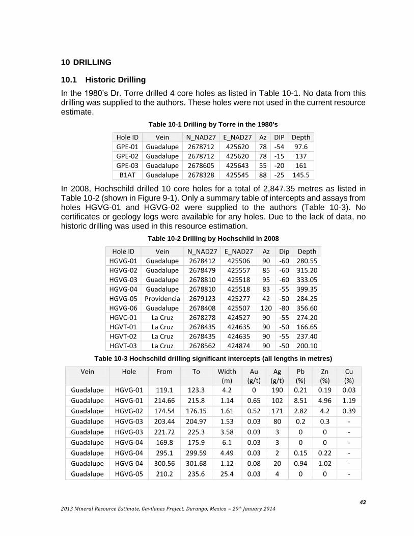
10 Drilling ........................................................................................................................... 43
10.1 Historic Drilling...................................................................................................... 43
10.2 Santacruz Drilling ................................................................................................... 44
11 Sample Preparation, Analyses, and Security ............................................................. 48
11.1 Sample Preparation and Analysis ........................................................................... 48
11.2 Field Blanks ............................................................................................................ 49
11.3 Standards ................................................................................................................ 50
11.4 Field Duplicates ...................................................................................................... 53
11.5 Sample Security ....................................................................................................... 55
12 Data Verification ........................................................................................................... 55
13 Mineral Processing and Metallurgical Testing .......................................................... 56
14 Mineral Resource Estimate .......................................................................................... 57
14.1 Data Analysis .......................................................................................................... 58
14.2 Composites .............................................................................................................. 65
14.3 Variography ............................................................................................................ 66
14.4 Block Model ............................................................................................................ 68
14.5 Bulk Density ............................................................................................................ 69
14.6 Grade Interpolation ................................................................................................ 69
14.7 Classification .......................................................................................................... 71
15 Adjacent Properties ...................................................................................................... 78

7
2013 Mineral Resource Estimate, Gavilanes Project, Durango, Mexico – 20th January 2014
16 Other Relevant Data and Information ........................................................................ 78
17 Interpretation and Conclusions ................................................................................... 79
18 Recommendations ......................................................................................................... 81
19 References ...................................................................................................................... 83
Appendix 1 – Listing of drill holes used in the resource estimate .................................... 85
Appendix 2 – Variography for Silver .................................................................................. 86
Appendix 3 – Specific Gravity Measurements ................................................................... 97
Appendix 4 – Drill hole cross-sections .............................................................................. 103

8
2013 Mineral Resource Estimate, Gavilanes Project, Durango, Mexico – 20th January 2014
List of Figures
Figure 4-1 Santacruz Concession Map ............................................................................................ 22
Figure 5-1 Gavilanes Project location ............................................................................................. 25
Figure 7-1 Geologic map of the central SMO ................................................................................... 29
Figure 7-2 Generalized geology based on Government mapping ................................................. 30
Figure 7-3 Simplified stratigraphic column for Gavilanes ............................................................. 31
Figure 7-4 Unmineralized andesite lithic tuff ................................................................................... 32
Figure 7-5 Unmineralized andesite crystal tuff ................................................................................ 32
Figure 7-6 Mineralized andesite ashfall tuff ..................................................................................... 33
Figure 7-7 Mineralized rhyolite dike ................................................................................................. 33
Figure 7-8 Schematic geologic model at Gavilanes........................................................................ 34
Figure 7-9 Average vein grades and mineralized interval. ............................................................. 35
Figure 7-10 Vein paragenesis ............................................................................................................ 36
Figure 7-11 Core photos showing mineral paragenesis. ............................................................... 37
Figure 7-12 Idealized section showing alteration............................................................................ 38
Figure 8-1 (a) Sulphide assemblages and sulphidation state. (b) relationship between salinity and metal solubility ................................................................................................................... 40
Figure 9-1 Surface sampling ............................................................................................................. 42
Figure 10-1 Gavilanes drill plan with surface samples ................................................................... 45
Figure 11-1 Field blanks showing certified Au values. ................................................................... 49
Figure 11-2 Au Standard SG66. ......................................................................................................... 51
Figure 11-3 Ag Standard SG49 .......................................................................................................... 52
Figure 11-4 Field duplicates original vs duplicate (Ag) .................................................................. 53
Figure 11-5 Field duplicates cumulative frequency plot for all metals ......................................... 54
Figure 14-1 Generalized Cross Section looking NW showing Mineralized Structures ............... 57
Figure 14-2 Dendrograph for each Domain ..................................................................................... 61
Figure 14-3 Lognormal cumulative frequency plot for Ag in DS HW-FW domain ....................... 62
Figure 14-4 Lognormal cumulative frequency plot for Ag in GP HW-FW domain ....................... 63
Figure 14-5 Isometric view looking N ............................................................................................... 68
Figure 14-6 Isometric view looking NW ............................................................................................ 72

9
2013 Mineral Resource Estimate, Gavilanes Project, Durango, Mexico – 20th January 2014
List of Tables
Table 1-1 Resource classed as Indicated within Mineralized Solids ............................................ 14
Table 1-2 Resource classed as Inferred within Mineralized Solids ............................................... 14
Table 1-3 Recommended work program budget ............................................................................. 16
Table 2-1 table of abbreviations ........................................................................................................ 18
Table 4-1 Gavilanes Project Mining Concessions........................................................................... 21
Table 9-1 Summary of surface and underground samples taken since 2010 by Santacruz. ..... 41
Table 10-1 Drilling by Torre in the 1980's ......................................................................................... 43
Table 10-2 Drilling by Hochschild in 2008 ........................................................................................ 43
Table 10-3 Hochschild drilling significant intercepts ..................................................................... 43
Table 10-4 Santacruz drilling by vein ............................................................................................... 44
Table 10-5 Guadalupe Vein significant drill intercepts ................................................................... 46
Table 10-6 Descubridora Vein significant drill intercepts .............................................................. 47
Table 10-7 San Nicolas Vein significant drill intercepts ................................................................. 47
Table 11-1 Summary of control sample certified values ................................................................ 48
Table 12-1 Check samples taken by author vs Santacruz (SC) results ........................................ 55
Table 14-1 Assay Statistics for all variables in all Domains .......................................................... 58
Table 14-2 Pearson Correlation Matrix for each Domain ............................................................... 59
Table 14-3 Silver Populations in DS HW-FW domain...................................................................... 63
Table 14-4 Capping Levels for all Domains ..................................................................................... 64
Table 14-5 Capped Assay Statistics for all variables in all Domains ............................................ 64
Table 14-6 2.5 m Composite Statistics for all variables in DS, GP, SN, STX and Waste Domains ..................................................................................................................................................... 65
Table 14-7: 0.5 m Composite Statistics for all variables in Vein DS and Vein GP Domains ....... 66
Table 14-8: Semivariogram Parameters for all variables ............................................................... 67
Table 14-9: Specific Gravity Determination sorted by Domain ...................................................... 69
Table 14-10: Kriging Parameters for Silver ...................................................................................... 70
Table 14-11: Resource classed as Indicated within Mineralized Solids ....................................... 73
Table 14-12: Resource classed as Inferred within Mineralized Solids.......................................... 74
Table 14-13: Resource classed as Indicated within Total Blocks ................................................. 74
Table 14-14: Resource classed as Inferred within Total Blocks .................................................... 74
Table 14-15 AgEq Resource classed as Indicated within Mineralized Solids .............................. 75
Table 14-16 AgEq Resource classed as Inferred within Mineralized Solids ................................ 76
Table 14-17 AgEq Resource classed as Indicated within Total Blocks ........................................ 76
Table 14-18 AgEq Resource classed as Inferred within Total Blocks .......................................... 77
Table 14-19 Mineralized Portion of Blocks above a 75 g/t Ag Cut-off ........................................... 77

10
2013 Mineral Resource Estimate, Gavilanes Project, Durango, Mexico – 20th January 2014
Table 17-1 Resource classed as Indicated within Mineralized Solids .......................................... 79
Table 17-2 Resource classed as Inferred within Mineralized Solids ............................................. 79
Table 18-1 Recommended work program budget (one year) ......................................................... 82

11
2013 Mineral Resource Estimate, Gavilanes Project, Durango, Mexico – 20th January 2014
1 SUMMARY
1.1 Introduction
The authors have been commissioned by Santacruz Silver Mining Ltd. (Santacruz) to prepare the first resource estimate for the Gavilanes Project located in Durango State, Mexico and write a Technical Report under the requirements of Canadian Securities Administrators National Instrument 43-101 (NI 43-101).
The resource estimate is based on drilling conducted by Santacruz in 2012 through 2013. The effective date of this mineral resource estimate is 13th November 2013. No work has been performed on the property since then.
The Gavilanes Project is an intermediate sulphidation (silver-base metal-gold) vein system, with veining identified within a 2.2 km2 area. The present resource estimate covers only an approximately 0.2 km2 surface area.
The Qualified Persons, as per definitions of NI 43-101, for this Technical Report are:
Gary Giroux, P.Eng., Giroux Consultants Ltd.
Hans Smit, P.Geo., Hans Smit, P.Geo.Inc.
Fletcher Bourke P.Geo., GBX Consulting Ltd.
1.2 Location, Mining Concessions, Surface Rights, Permits
The Gavilanes Project, or Gavilanes is located approximately 110km WNW of Durango City in the municipality of San Dimas in Durango State, Mexico. The center of the project area is located at UTM Zone 13, 425650E, 2678450N, North American Datum 27 (Mexico).
The property is located within the central part of the Sierra Madre Occidental, characterized by very rugged topography with steep, often vertical walled valleys and narrow canyons. Elevations on the property vary from 800 to 2400 metres above sea level.
Access to the property from Durango City involves 190 km of paved roads and 23 km of rough gravel roads and takes approximately 6 hours by driving.
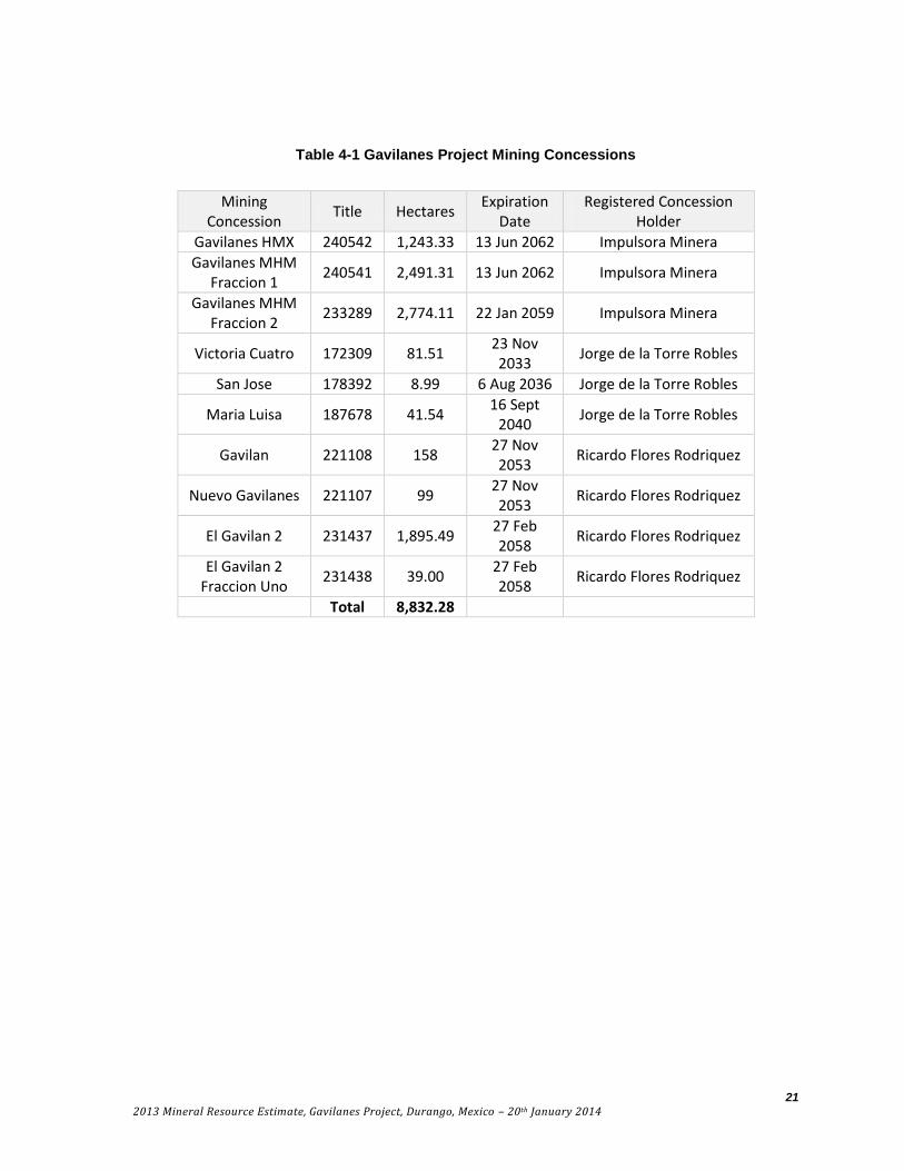
The Gavilanes Project includes 10 mining concessions covering a total area of 8,832.28 hectares. Santacruz’s rights to the concessions are held through its wholly owned Mexican subsidiary, Impulsora Minera Santacruz S.A. de C.V., (the Company) (Table 4-1 and Figure 4-1). The Company can acquire 100% of the mineral concessions pursuant to three agreements.

12
2013 Mineral Resource Estimate, Gavilanes Project, Durango, Mexico – 20th January 2014
a) Gavilanes I
Pursuant to an agreement with Jorge de la Torre Robles dated April 27, 2010, as amended October 12, 2010, December 27, 2010, October 29, 2011, January 30, 2012, March 20, 2012 and April 26, 2013, the Company was granted an option to acquire a 100% interest in the Victoria Cuatro, San Jose and Maria Luisa claims The claims are subject to a 3% net smelter return royalty (NSR) in favour of the optionor, up to a maximum of $2,000,000.
To maintain and exercise the option, the Company must make $3,600,000 of cash payments to the vendor. As at September 30, 2013, the Company has made total payments of $2,500,000 and must make one residual payment of $1,100,000 on April 1, 2014.
b) Gavilanes II
Pursuant to an agreement with Ricardo Flores Rodriguez dated May 1, 2010, as amended October 12, 2010, December 27, 2010 and January 7, 2011, the Company was granted an option to acquire a 100% interest in the Nuevo Gavilanes, Gavilan, El Gavilan 2 and El Gavilan 2 Fraccion Uno claims. The claims are subject to a 2% NSR in favour of the optionor, up to a maximum of $1,000,000. The NSR may be purchased by the Company for $1,000,000. To maintain and exercise the option, the Company must make $2,265,000 of cash payments to the property vendor. As at September 30, 2013, the Company has made total payments of $715,000 and the residual payments are as follows:
$400,000 on April 1, 2014; and
$1,150,000 on May 1, 2014.
c) Gavilanes MHM Fraccion
Pursuant to an agreement with Minera Hochschild, S.A., de C.V (Hochschild) dated January 5, 2012, as amended on February 20, 2012 and March 23, 2012, the Company acquired the Gavilanes MHM Fraccion 2 and Gavilanes HMX concessions and Gavilanes MHM Fraccion 1 for cash payments of $100,000 made on April 15, 2012 and $1,000,000 upon commencement of commercial production out of these specific claims, and the grant to the vendor of a 3% NSR.
Surface rights in the project area are owned by the Gavilanes Ejido (agrarian community). Santacruz has executed a surface access agreement with the Ejido, allowing them access to conduct exploration work. The existing agreement permits exploration activities only. Exploitation and production activities will require execution of a new access agreement. The authors were given a copy of the current surface access agreement between Santacruz and the Gavilanes Ejido but no legal review was made of the document.

13
2013 Mineral Resource Estimate, Gavilanes Project, Durango, Mexico – 20th January 2014
The Gavilanes project is not included within any specially protected, Federally designated, ecological zones. Therefore basic exploration activities are regulated under Norma Oficial Mexicana NOM-120-SEMARNAT-2011.
1.3 Exploration and Drilling
Very little modern exploration was conducted on the property prior to 2010. Since 2010, Santacruz has taken 140 surface samples and 31 underground samples. Surface samples collected were taken along the known veins in a 4 km2 area surrounding the resource area. Samples were typically chip-grab or channel samples. Surface sampling shows mineralized veins extending at least 2km to the west of the current resource area. More sampling and mapping is warranted given the encouraging results of the surface sampling to date.
Drilling began at the Gavilanes Project by Santacruz in August 2012 with 9,623.9 metres of HQ core drilled to July 2013 in 47 holes. There has been no drilling on the property since then.
1.4 Data Verification and Site Visit
Smit and Bourke conducted an on-site visit to Gavilanes from the 20th to 25th of October 2013. Thirty-six of the total 47 holes drilled by Santacruz were re-logged by the authors. During this time, the Santacruz logging and results from ALS Limited’s Global Minerals Division (ALS) were also checked while visually inspecting the core. In addition, hole collar locations, geologic mapping and mine workings were checked against the digital data supplied by Santacruz to the authors. The logging by the authors was used to construct the domain model for the resource estimate as described in Section 7.5.
1.5 Geology
Mineralization at the Gavilanes Project is hosted within a volcanic sequence of andesite fragmentals and flows of the Lower Volcanic Group (LVG), and is classified as an intermediate sulphidation epithermal deposit based on the alteration assemblages and mineralogy.
Silver, base metal and gold mineralization at Gavilanes is hosted by crustiform-banded quartz veins, quartz vein stockworks, and breccia veins hosted within the andesites of the LVG. The veins are oriented NNW and NW and dip moderately to the W-SW. Veins pinch and swell, varying from < 3cm to 14m wide and averaging 3.5m. Vein contacts are frequently not sharp and there is generally an abundant wallrock component to the veins. Some of the veins have a strike length of over two kilometers. The dominant ore minerals include native silver, argentite, sphalerite, galena, and chalcopyrite with gangue minerals including quartz, pyrite, K-feldspar, chlorite, epidote, sericite, calcite, barite and ilmenite. Alteration styles include propylitic, argillic, silicic and quartz vein stockworks and vein breccia.
14
2013 Mineral Resource Estimate, Gavilanes Project, Durango, Mexico – 20th January 2014
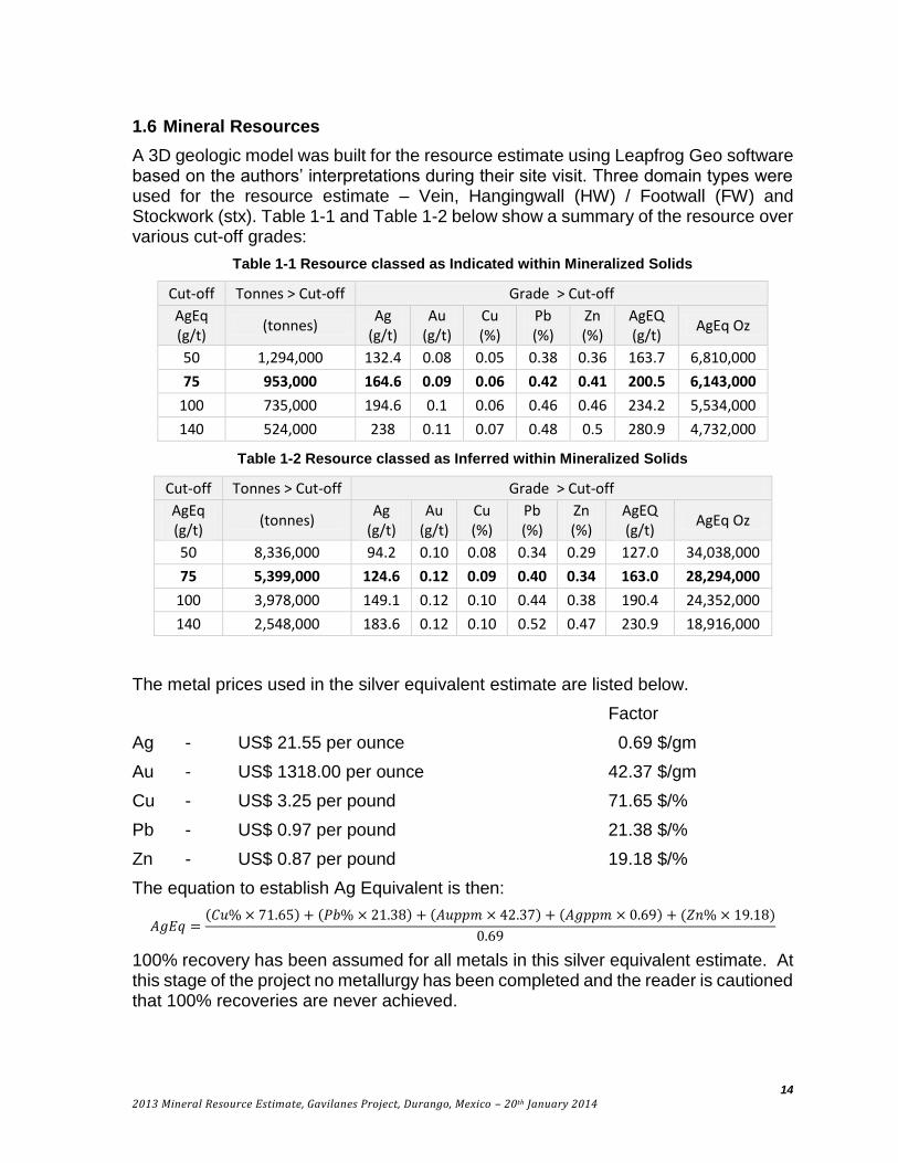
1.6 Mineral Resources
A 3D geologic model was built for the resource estimate using Leapfrog Geo software based on the authors’ interpretations during their site visit. Three domain types were used for the resource estimate – Vein, Hangingwall (HW) / Footwall (FW) and Stockwork (stx). Table 1-1 and Table 1-2 below show a summary of the resource over various cut-off grades:
Table 1-1 Resource classed as Indicated within Mineralized Solids
Cut-off Tonnes > Cut-off Grade > Cut-off
AgEq (g/t)
(tonnes) Ag
(g/t) Au
(g/t) Cu (%)
Pb (%)
Zn (%)
AgEQ (g/t)
AgEq Oz
50 1,294,000 132.4 0.08 0.05 0.38 0.36 163.7 6,810,000
75 953,000 164.6 0.09 0.06 0.42 0.41 200.5 6,143,000
100 735,000 194.6 0.1 0.06 0.46 0.46 234.2 5,534,000
140 524,000 238 0.11 0.07 0.48 0.5 280.9 4,732,000
Table 1-2 Resource classed as Inferred within Mineralized Solids
Cut-off Tonnes > Cut-off Grade > Cut-off
AgEq (g/t)
(tonnes) Ag
(g/t) Au
(g/t) Cu (%)
Pb (%)
Zn (%)
AgEQ (g/t)
AgEq Oz
50 8,336,000 94.2 0.10 0.08 0.34 0.29 127.0 34,038,000
75 5,399,000 124.6 0.12 0.09 0.40 0.34 163.0 28,294,000
100 3,978,000 149.1 0.12 0.10 0.44 0.38 190.4 24,352,000
140 2,548,000 183.6 0.12 0.10 0.52 0.47 230.9 18,916,000
The metal prices used in the silver equivalent estimate are listed below.
Factor
Ag - US$ 21.55 per ounce 0.69 $/gm
Au - US$ 1318.00 per ounce 42.37 $/gm
Cu - US$ 3.25 per pound 71.65 $/%
Pb - US$ 0.97 per pound 21.38 $/%
Zn - US$ 0.87 per pound 19.18 $/%
The equation to establish Ag Equivalent is then:
𝐴𝑔𝐸𝑞 =(𝐶𝑢% × 71.65) + (𝑃𝑏% × 21.38) + (𝐴𝑢𝑝𝑝𝑚 × 42.37) + (𝐴𝑔𝑝𝑝𝑚 × 0.69) + (𝑍𝑛% × 19.18)
0.69
100% recovery has been assumed for all metals in this silver equivalent estimate. At this stage of the project no metallurgy has been completed and the reader is cautioned that 100% recoveries are never achieved.

15
2013 Mineral Resource Estimate, Gavilanes Project, Durango, Mexico – 20th January 2014
Highlights of the mineral resource estimate are as follows:
Indicated mineral resources of 6,143,000 AgEq ounces grading 200 g/t AgEq
Inferred mineral resource of 28,294,000 AgEq ounces grading 163 g/t AgEq;
Veins remain open along strike and to depth with intermittent surface exposures indicating an untested strike length;
The stockwork zone is open down-dip and to the south.
1.7 Conclusions and Recommendations
The identified indicated and inferred resource is significant (Table 1-1 and Table 1-2), however engineering and economic studies have not been completed and thus no statement can be made about the project’s potential economic viability.
The full limits of the veins that host the resource have not yet been delineated and potential exists to increase the resource by expansion along strike and to depth. There are a number of other vein structures on the property which provide further exploration potential.
The results achieved to date at Gavilanes warrant continued exploration including drilling to upgrade and potentially expand resources. A program of metallurgy and basic engineering to assess the project’s economic viability is also warranted.
There are no obvious environmental, permitting, legal, title, taxation, socio-economic, marketing, political or other relevant factors which would materially affect this resource. Further exploration of the Gavilanes Project is subject to normal exploration risks including the ability of Santacruz to raise funding, potential decreases in metal prices and unforeseen changes in Mexican mining and environmental laws and regulations.
Recommended work at Gavilanes includes drilling in the area of current resources with the intent of upgrading resources to Indicated and Measured, drilling the open extent of the area with resources, testing other targets on the property and undertaking preliminary metallurgy, engineering and environmental studies.
The recommended work plan is a one year program and includes:
Prepare an orthophoto and detailed topographic model for the property.
Map the property at 1:10,000 or smaller scale as appropriate.
Continue the surface sampling program.
Drill to upgrade resources – approximately 8,000 metres of HQ core in 50 holes.
Drill to potentially expand resources - approximately 6,000 metres in 30 holes.
Drill other veins to test potential – approximately 4,000 metres in 30 holes.
Conduct preliminary metallurgy studies on the current Domains – 6 composites.
Start a baseline sampling program on the creeks.
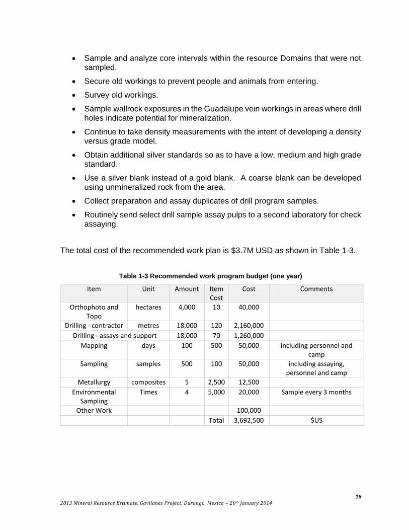
16
2013 Mineral Resource Estimate, Gavilanes Project, Durango, Mexico – 20th January 2014
Sample and analyze core intervals within the resource Domains that were not sampled.
Secure old workings to prevent people and animals from entering.
Survey old workings.
Sample wallrock exposures in the Guadalupe vein workings in areas where drill holes indicate potential for mineralization.
Continue to take density measurements with the intent of developing a density versus grade model.
Obtain additional silver standards so as to have a low, medium and high grade standard.
Use a silver blank instead of a gold blank. A coarse blank can be developed using unmineralized rock from the area.
Collect preparation and assay duplicates of drill program samples.
Routinely send select drill sample assay pulps to a second laboratory for check assaying.
The total cost of the recommended work plan is $3.7M USD as shown in Table 1-3.
Table 1-3 Recommended work program budget (one year)
Item Unit Amount Item Cost
Cost Comments
Orthophoto and Topo
hectares 4,000 10 40,000
Drilling - contractor metres 18,000 120 2,160,000
Drilling - assays and support 18,000 70 1,260,000
Mapping days 100 500 50,000 including personnel and camp
Sampling samples 500 100 50,000 including assaying, personnel and camp
Metallurgy composites 5 2,500 12,500
Environmental Sampling
Times 4 5,000 20,000 Sample every 3 months
Other Work 100,000
Total 3,692,500 $US

17
2013 Mineral Resource Estimate, Gavilanes Project, Durango, Mexico – 20th January 2014
2 INTRODUCTION
The purpose of this report is to provide an independent assessment of the Gavilanes Project and, in particular, to provide an independent mineral resource estimate for the project. Gavilanes is a mineral exploration project located in Durango State, Mexico that is being explored for silver, gold and base metals. Santacruz commissioned H. Smit, P. Geo. (Smit), and F. Bourke, P. Geo. (Bourke), to review the project, develop a geological model for the area drilled, direct the development of a resource estimate, make recommendations on further work, and prepare a Technical Report in accordance with NI 43-101. Santacruz commissioned Giroux Consulting Ltd. (Giroux) to estimate the precious and base metal resources for the project based upon the geologic and mineralized domain model created by Smit and Bourke.
Santacruz is a public company trading on the TSX Venture exchange under the symbol SCZ. Smit, Giroux and Bourke are Qualified Persons as defined by NI 43-101 and are independent of both Santacruz and the title holders, based on the tests outlined in NI 43-101.
This report is subsequent to a previous December 2011 Technical Report authored by M.C. Newton, III, Ph.D. and D.E. Hulse, P.E. of Gustavson Associates titled, “Geology, Mineralization and Historical Exploration Results, Gavilanes, Mexico” dated December 20, 2011. This report has been prepared pursuant to NI 43-101 standards.
The effective date of this mineral resource estimate is 13th November 2013. No work has been performed on the property since then.
2.1 Sources of Information
Information for this Technical Report includes Smit and Bourke’s independent observations, assay data obtained directly from ALS and geologic maps and drillhole information supplied by Santacruz. Details on mineral titles, surface access agreements and permitting were obtained from Arturo Prestamo, President of Santacruz. The report also references published reports as listed in Section 19.
This Technical Report incorporates contributions by Bourke, Smit and Giroux, all Qualified Persons as defined by NI 43-101. Giroux was responsible for Section 14. All other sections were authored by Bourke and Smit.
2.2 Field Examination and Data Review by the Qualified Person.
Smit and Bourke visited the Gavilanes Project from the 20th to 25th of October 2013. During this time, approximately 36 core holes were relogged. In addition, hole collar locations, geologic mapping and mine workings were checked against the digital data supplied by Santacruz to the authors.
Giroux has not visited the project but has relied on the geological data and information verified by Bourke and Smit.
18
2013 Mineral Resource Estimate, Gavilanes Project, Durango, Mexico – 20th January 2014
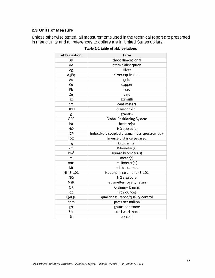
2.3 Units of Measure
Unless otherwise stated, all measurements used in the technical report are presented in metric units and all references to dollars are in United States dollars.
Table 2-1 table of abbreviations
Abbreviation Term
3D three dimensional
AA atomic absorption
Ag silver
AgEq silver equivalent
Au gold
Cu copper
Pb lead
Zn zinc
az azimuth
cm centimeters
DDH diamond drill
g gram(s)
GPS Global Positioning System
ha hectare(s)
HQ HQ size core
ICP Inductively coupled plasma mass spectrometry
ID2 inverse distance squared
kg kilogram(s)
km Kilometer(s)
km2 square kilometer(s)
m meter(s)
mm millimeter(s )
Mt million tonnes
NI 43-101 National Instrument 43-101
NQ NQ size core
NSR net smelter royalty return
OK Ordinary Kriging
oz Troy ounces
QAQC quality assurance/quality control
ppm parts per million
g/t grams per tonne
Stx stockwork zone
% percent

19
2013 Mineral Resource Estimate, Gavilanes Project, Durango, Mexico – 20th January 2014
3 RELIANCE ON OTHER EXPERTS
The majority of work in this report is based on data obtained from the authors’ site visit, digital data supplied by Santacruz, and assay data obtained directly from ALS. The conclusions presented in this report are based on the work of Qualified Persons, as defined under NI 43-101.
An independent review of the key mineral titles was performed by Mauricio Heiras Garibay, a lawyer based in Chihuahua, Mexico. The conclusion that Santacruz controls the mineral titles that encompass the area of the resources described herein is based on an opinion by Heiras dated January 7, 2014 as detailed in Section 4-2.
Copies of environmental permits received from Santacruz were reviewed by Patricia Aquayo, an environmental consultant based in Hermosillo, Mexico. The conclusion that Santacruz has a current authorization to allow exploration activities, as described in Section 4-5, is based on email communications with Aquayo in December 2014.
Best professional judgment was utilized in the collection and interpretation of data discussed in this report. However, users of this report are cautioned that the valuation methods used herein are subject to inherent uncertainties and assumptions, over which the authors have no control. These uncertainties and assumptions are stated herein. Users of this report are hereby advised to be aware of and understand these uncertainties and assumptions.
4 PROPERTY DESCRIPTION AND LOCATION
4.1 Area and Location
The Gavilanes Project is located approximately 110km WNW of Durango City in the municipality of San Dimas in Durango State, Mexico. The center of the project area is located at UTM Zone 13, 425650E, 2678450N, North American Datum 27 (Mexico).
All geographic coordinates in this report utilize North American Datum 27 (Mexico) Zone 13 (NAD27).
4.2 Title and Ownership
Mining and exploration rights in Mexico are controlled by the Federal Government. The mining concessions are administered by the Direccion General de Minas (DGM), a subsecretariat of the cabinet level Secretaria de Economia. To maintain concessions in good legal standing, concession holders are obligated to pay semi-annual tax payments and to annually file documentation of exploration or development work on the concession. New mining concessions are valid for a renewable 50 year period.
The Gavilanes Project includes 10 mining concessions covering a total area of 8,832.28 hectares. Santacruz’s rights to the concessions are held through its wholly owned Mexican Subsidiary, Impulsora Minera Santacruz S.A. de C.V., (the Company) (Table 4-1 and Figure 4-1). The Company can acquire 100% of the mineral concessions pursuant to three separate option agreements (Gavilanes I, II and MHM). Details of these are as follows:
20
2013 Mineral Resource Estimate, Gavilanes Project, Durango, Mexico – 20th January 2014
a) Gavilanes I
Pursuant to an agreement with Jorge de la Torre Robles dated April 27, 2010, as amended October 12, 2010, December 27, 2010, October 29, 2011, January 30, 2012, March 20, 2012 and April 26, 2013, the Company was granted an option to acquire a 100% interest in the Victoria Cuatro, San Jose and Maria Luisa claims The claims are subject to a 3% net smelter return royalty (NSR) in favour of the optionor, up to a maximum of $2,000,000.
To maintain and exercise the option, the Company must make $3,600,000 of cash payments to the vendor. As at September 30, 2013, the Company has made total payments of $2,500,000 and must make one residual payment of $1,100,000 on April 1, 2014.
b) Gavilanes II
Pursuant to an agreement with Ricardo Flores Rodriguez dated May 1, 2010, as amended October 12, 2010, December 27, 2010 and January 7, 2011, the Company was granted an option to acquire a 100% interest in the Nuevo Gavilanes, Gavilan, El Gavilan 2 and El Gavilan 2 Fraccion Uno claims. The claims are subject to a 2% NSR in favour of the optionor, up to a maximum of $1,000,000. The NSR may be purchased by the Company for $1,000,000. To maintain and exercise the option, the Company must make $2,265,000 of cash payments to the property vendor. As at September 30, 2013, the Company has made total payments of $715,000 and the residual payments are as follows:
$400,000 on April 1, 2014; and
$1,150,000 on May 1, 2014.
c) Gavilanes MHM Fraccion
Pursuant to an agreement with Minera Hochschild, S.A., de C.V (Hochschild) dated January 5, 2012, as amended on February 20, 2012 and March 23, 2012, the Company acquired the Gavilanes MHM Fraccion 2 and Gavilanes HMX concessions and Gavilanes MHM Fraccion 1 for cash payments of $100,000 made on April 15, 2012 and $1,000,000 upon commencement of commercial production out of these specific claims, and the grant to the vendor of a 3% NSR.
The authors commissioned a title review of the mineral claims that cover the resource and immediate exploration area around the resource area. The titles reviewed were the Victoria Cuatro, San Jose, Maria Luisa, Gavilan, Nuevo Gavilanes, El Gavilan 2 and El Gavilan 2 Fraccion Uno. The review confirmed that these titles are valid and that an agreement between the registered concession owners and the Company has been registered. The authors have relied on statements by Santacruz that the property taxes payable on the mineral titles that comprise the Gavilanes Project will be approximately $31,000 for 2014, and that all taxes and assessment requirements have been met for the mineral titles.
21
2013 Mineral Resource Estimate, Gavilanes Project, Durango, Mexico – 20th January 2014
Table 4-1 Gavilanes Project Mining Concessions
Mining Concession
Title Hectares Expiration
Date Registered Concession
Holder
Gavilanes HMX 240542 1,243.33 13 Jun 2062 Impulsora Minera
Gavilanes MHM Fraccion 1
240541 2,491.31 13 Jun 2062 Impulsora Minera
Gavilanes MHM Fraccion 2
233289 2,774.11 22 Jan 2059 Impulsora Minera
Victoria Cuatro 172309 81.51 23 Nov 2033
Jorge de la Torre Robles
San Jose 178392 8.99 6 Aug 2036 Jorge de la Torre Robles
Maria Luisa 187678 41.54 16 Sept
2040 Jorge de la Torre Robles
Gavilan 221108 158 27 Nov 2053
Ricardo Flores Rodriquez
Nuevo Gavilanes 221107 99 27 Nov 2053
Ricardo Flores Rodriquez
El Gavilan 2 231437 1,895.49 27 Feb 2058
Ricardo Flores Rodriquez
El Gavilan 2 Fraccion Uno
231438 39.00 27 Feb 2058
Ricardo Flores Rodriquez
Total 8,832.28

22
2013 Mineral Resource Estimate, Gavilanes Project, Durango, Mexico – 20th January 2014
Figure 4-1 Santacruz Concession Map
23
2013 Mineral Resource Estimate, Gavilanes Project, Durango, Mexico – 20th January 2014
4.3 Surface Rights
Surface rights in the project area are owned by the Gavilanes Ejido (agrarian community). Santacruz has executed a surface access agreement with the Ejido, allowing them access to conduct exploration work. The existing agreement permits exploration activities only. Exploitation and production activities will require negotiation of a new access agreement. The authors were given a copy of the current surface access agreement between the Company and the Gavilanes Ejido but no legal review was made of the document.
4.4 Environmental Liability
There are a number of adits, stopes and small shafts at the Gavilanes Project from previous mining activity. None appear to be creating significant acid rock drainage (ARD) or metal leaching, but some are open and should be secured to prevent people and animals from falling in. There is a small amount of tailings from historic mining that should be tested and if the material is leaching metals it should be removed.
Though there are no obvious significant environmental liabilities evident, a sampling program of the creeks should be initiated to verify that there are no ARD or metal leaching issues. Sampling will also provide baseline data for the water quality in the streams before any major disturbance is undertaken by Santacruz.
4.5 Permits
Exploration and mining activities in Mexico are subject to control by the Secretaria del Medio Ambiente y Recursos Naturales (Secretary of the Environment and Natural Resources), known by its acronym SEMARNAT, and regulated by the General Law of Ecological Equilibrium and Environmental Protection (Ley General de Equilibrio Ecologico y Proteccion al Ambiente, or LGEEPA). For exploration activities, including mapping, geochemical sampling, geophysical surveys, mechanized trenching, road building, and drilling, if each particular activity does not exceed a defined threshold for surface disturbance, which varies by activity, and if in aggregate these activities will affect less than 25% of the project surface area, LGEEPA allows for an exemption from the requirement to prepare an Enivronmental Impact Statement (Manifiesto de Impacto Ambiental) and instead allows the exploration activities to be regulated under Norma Oficial Mexicana NOM-120-ECOL-2011. In place of an Environmental Impact Statement, the applicant must submit and obtain approval of an Informe Preventivo which describes the exploration activities and the accompanying environmental mitigation and restoration procedures.
The Gavilanes project is not included within any specially protected, Federally designated, ecological zones. Therefore basic exploration activities conducted to date have been regulated under Norma Oficial Mexicana NOM-120-ECOL-2011.
If the activities permitted under NOM-120-SEMARNAT-2011 and approved in the Informe Preventivo require clearing of natural vegetation, then a Land Use Change authorization (Cambio de Uso de Suelos, CUS) is required. A Land Use Change application consists of a Technical Justification Study (Estudio Tecnico Justificativo)

24
2013 Mineral Resource Estimate, Gavilanes Project, Durango, Mexico – 20th January 2014
which describes in detail the areas to be cleared and the types of vegetation affected. The Land Use Change permit will be issued within 60 working days of submittal if it is approved. If the permit is not issued within this period it is considered as denied. NOM-120-SEMARNAT-2011 defines the impact mitigation procedures that must be followed for each activity.
The current Land Use Change permit for the Gavilanes project has a validity of 18 months (due date April 15, 2015) and allows 21 drill pads and 9,308m of drilling. There are some commitments derived from the Informe Preventivo and the Land Use Change authorization, such as a flora protection program, reforestation activities, progress reports on the environmental program and a final report on environmental restoration after conclusion of exploration activities.
The current permit will allow a substantial portion of the work recommended in section 18 to be completed. However, a permit amendment or a new Land Use permit will be required to complete all the recommended drill holes or possibly an Environmental Impact Statement if NOM-120-SEMARNAT-2011 thresholds are exceeded.
The Advanced exploration activities, mine construction and operation activities require preparation and approval of a number of documents and various permits will need to be obtained. At this point in time, Santacruz has not started any of the studies or applied for any of the permits required for a mine. The authors are not aware of any issues related to Gavilanes which would make it difficult or impossible to obtain these permits.

25
2013 Mineral Resource Estimate, Gavilanes Project, Durango, Mexico – 20th January 2014
5 ACCESSIBILITY, CLIMATE, LOCAL RESOURCES, INFRASTRUCTURE, AND PHYSIOGRAPHY
5.1 Access
The Gavilanes Project is located in the San Dimas, Durango Mining District, 110 Km west from Durango City, and 23 Km Northeast from the Tayoltita mine. Access to the property from Durango City takes approximately 6 hours by driving and is as follows (Figure 5-1):
Drive west to Estacion Coyotes on Federal Highway 40 (90 km – main Mazatlan-Durango toll road).
Turn North to San Miguel de Cruces (100 km – paved road).
Drive South to Gavilanes Village (23km – rough dirt road).
Figure 5-1 Gavilanes Project location (concession shown in orange)

26
2013 Mineral Resource Estimate, Gavilanes Project, Durango, Mexico – 20th January 2014
5.2 Climate
The climate in the area is semi-tropical, characterized by relatively high temperatures and humidity, with hot summers (35ºC) and mild winters. At higher elevations, frosts can occur in winter (November to March). Average annual temperatures are 15ºC. Precipitation is mainly during June to September with average annual precipitation ranging from 660 to 1000 mm per year. The climate should not interfere with year round operations.
5.3 Local Resources and Infrastructure
The project area encompasses the village of Gavilanes (population of 150) and the resources defined to date are located directly adjacent to the village. The village offers little infrastructure beyond a small federally subsidized grocery store. The town of San Miguel de Cruces (population around 1,800), located 23 km to the north, has basic services. The federally owned and operated electric transmission grid extends to San Miguel de Cruces, but there is likely insufficient capacity on this line to run a crushing plant and mill. The city of Durango has skilled labor and is an established supply center for mining and exploration.
The Project is located in an area of moderate rainfall with water potentially available to supply mine activities. At present, the Company has not secured any subsurface or surface water rights.
5.4 Physiography
The property is located within the central part of the Sierra Madre Occidental, characterized by very rugged topography with steep, often vertical walled valleys and narrow canyons. Elevations on the property vary from 800 to 2400 metres above sea level.
Vegetation in the area consists mainly of pine, juniper and oak trees at higher elevations with the lower slopes dominated by thick brush, cactus and grasses. Subsistence farming, ranching, mining and timber cutting are the predominant activities of the region’s population.
Finding suitable sites for mine infrastructure such as tailing impoundments close to the existing resource will be challenging, but there are lower relief areas in the broader area that could possibly be suitable.
6 HISTORY
The following section is in part summarized from previous reports on Gavilanes and Tayoltita (Newton & Hulse 2011, Spring & Watts 2011).
The San Dimas district has experienced a long history of mining dating back to at least 1757. Mining began at the Las Queleles area (near the present town of Tayoltita), which by 1795 was a town of 10,000 Spanish residents. Mining at the Gavilanes Project probably began around this time. It is thought early ore was processed close to the El Pilar prospect - just west of the Gavilanes Project current resource area. The Spanish continued working the area up to the start of the Mexican War of

27
2013 Mineral Resource Estimate, Gavilanes Project, Durango, Mexico – 20th January 2014
Independence (1810). Mining then decreased and activity in the district didn’t resume until the 1880’s when Mr. Granaos and Mr. Gonzales from Guatemala revived the old Gavilanes mine. Silver ingots where produced and shipped to Guatemala.
Later, operations were overtaken by an English company that minted coins in India. Mining at this time focused on the Descubridora and Aranzazu Veins. Historical records reportedly estimate that 20,000 tons of ore grading 1,750g/t Ag were mined.
The English company went bankrupt and was overtaken by an American capital firm, Luismin Mining Company, in the 1920’s. Luismin (now Goldcorp) was more focused on their properties in Tayoltita and after some work on the Soledad and Alto Vein let the Gavilanes Project fall to the wayside. Mexico later introduced a new mining law in 1959 requiring the majority of a Mexican mining company to be held by Mexicans.
Exploration didn’t begin on the project again until the 1980’s by a successor company to Luismin called San Luis S.A de C.V (which also operated the Tayoltita mine).
In 1984 Dr. Jorge de la Torre, through a Government loan, installed a 120 ton/day mill at the Gavilanes property to process mine dumps. Dr. Torres also drilled 4 core holes totaling 540m on the Guadalupe and Descubridora Veins. Low silver prices forced the project to close.
Modern exploration began in 2008 when Hochschild started an exploration program in the area (see Section 10 for more details). 71 surface samples were taken along with some limited mapping. Following this they drilled 10 core holes (2,847m total) which yielded narrow mineralized intercepts in the Guadalupe vein, the results available are detailed in Table 10-2 of this report. Subsequently Hochschild suspended activities at the project.
In 2010 Santacruz acquired the project from Hochschild. Drilling began on the project in late 2012 with 47 core holes totaling 9,624m drilled that year and 2013. Activities completed since 2010 are outlined in full in Sections 9 and 10.2.

28
2013 Mineral Resource Estimate, Gavilanes Project, Durango, Mexico – 20th January 2014
7 GEOLOGICAL SETTING AND MINERALIZATION
7.1 Regional Geology
The Gavilanes Project lies within the Southern part of the Sierra Madre Occidental (SMO) as shown in Figure 7-1. The interested reader is referred to detailed descriptions of the geology of the SMO published by previous writers (Ferrari et al 2007) and the geology of the SMO is only summarized in this report.
The SMO is a regionally extensive volcanic field created as the result of Cretaceous-Cenozoic magmatic and tectonic episodes related to subduction of the Farallon plate beneath the North American plate. The stratigraphy of the SMO consists of five main igneous complexes (oldest to youngest):
1. Late Cretaceous to Paleocene plutonic and volcanic rocks
2. Eocene andesites and lesser rhyolites – Traditionally called the Lower Volcanic Group (LVG)
3. Silicic ignimbrites, mainly Oligocene (32-28 Ma) and Early Miocene (24-20 Ma) – Grouped into the Upper Volcanic Group (UVG)
4. Transitional basaltic-andesitic lavas erupted toward the end of each ignimbrite pulse
5. Post subduction volcanics consisting of alkaline basalts and ignimbrites
Mineralization at the Gavilanes Project is hosted near the top of the LVG.
The San Dimas district lies within an area of complex normal faulting along the western edge of the SMO. Compressive forces first formed predominantly E-W and E-NE tension gashes, which were later cut by transgressive N-NW striking slip faults. Later extensional deformation beginning in the end of the Eocene formed N-S to NNW-SSE high angle normal faults (Basin and Range faulting).

29
2013 Mineral Resource Estimate, Gavilanes Project, Durango, Mexico – 20th January 2014
Figure 7-1 Geologic map of the central SMO (modified from Ferrari et al 2007)
30
2013 Mineral Resource Estimate, Gavilanes Project, Durango, Mexico – 20th January 2014
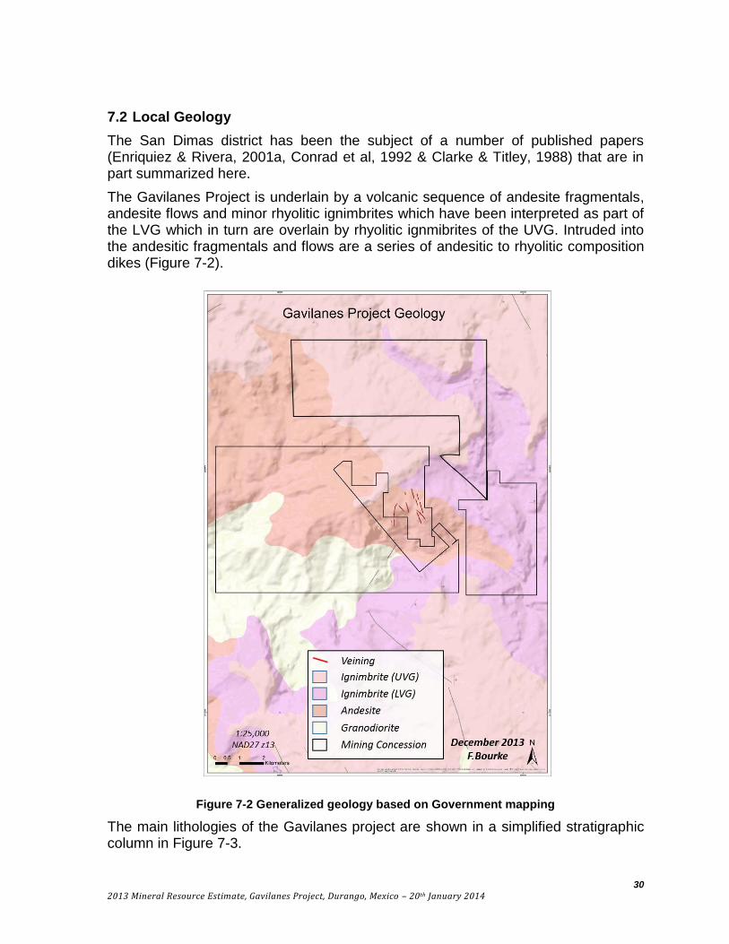
7.2 Local Geology
The San Dimas district has been the subject of a number of published papers (Enriquiez & Rivera, 2001a, Conrad et al, 1992 & Clarke & Titley, 1988) that are in part summarized here.
The Gavilanes Project is underlain by a volcanic sequence of andesite fragmentals, andesite flows and minor rhyolitic ignimbrites which have been interpreted as part of the LVG which in turn are overlain by rhyolitic ignmibrites of the UVG. Intruded into the andesitic fragmentals and flows are a series of andesitic to rhyolitic composition dikes (Figure 7-2).
Figure 7-2 Generalized geology based on Government mapping
The main lithologies of the Gavilanes project are shown in a simplified stratigraphic column in Figure 7-3.

31
2013 Mineral Resource Estimate, Gavilanes Project, Durango, Mexico – 20th January 2014
Figure 7-3 Simplified stratigraphic column for Gavilanes as determined by F. Bourke.
Descriptions of the units are as follows:

32
2013 Mineral Resource Estimate, Gavilanes Project, Durango, Mexico – 20th January 2014
7.2.1 The Andesites of the LVG
The andesities of the LVG are the main host to mineralization and were previously mapped and logged as a single unit. This unit is thought to be the same unit as the Productive Andesite at Tayoltita. At Gavilanes it has been divided into 3 principal groups based on composition and texture by the authors. The units strike 345º and dip 25º ENE and are grouped as follows:
Andesite lithic tuff – Lapilli tuff with 10 to 30% fragments typically ranging from 1 to 3 cm in size. These units occur intercalated with Andesite crystal tuff in layers ranging in thickness from 1 to 100 metres with local variations in fragment size (Figure 7-4). At Tayoltita the unit is over 750m thick.
Andesite crystal tuff – Lapilli tuff with 5 to 20% crystals (mainly plagioclase) typically ranging in size from 1 to 3mm (Figure 7-5).
Andesite ashfall tuff – typically <5% crystals with a size <2mm (Figure 7-6).
Figure 7-4 Unmineralized andesite lithic tuff (core left, outcrop right)
Figure 7-5 Unmineralized andesite crystal tuff in core left and outcrop right.

33
2013 Mineral Resource Estimate, Gavilanes Project, Durango, Mexico – 20th January 2014
Figure 7-6 Mineralized andesite ashfall tuff (Chlorite-sericite alteration with abundant chalcopyrite, galena and sphalerite on stockwork veinlet margins - 500g/tAg, 6g/tAu, 5%Pb,
2%Cu, 0.5%Zn)
7.2.2 Lower Rhyolite Ignimbrites (LVG)
A rhyolitic ignimbrite of the LVG overlies the andesites. The rhyolite is thought to be approximately 300m thick and exposed on the upper slopes above approximately 2400m elevation. Weak alteration is seen where the veins project into this unit.
7.2.3 Dikes
The project area has an abundance of dikes usually spatially associated with veining. The veins are emplaced along the margins and into the dikes as shown in Figure 7-8. Dike compositions vary from andesite to rhyolite. The dikes range in width from 0.5 to 20m in width and strike mainly NNW with a dip of 50-65º. The dikes are mainly pre-mineral and follow pre-existing structural features (Figure 7-7). There are some post mineral green andesitic dykes.
Figure 7-7 Mineralized rhyolite dike (early Ag-Pb-Zn mineralization cut by late qtz veins)
34
2013 Mineral Resource Estimate, Gavilanes Project, Durango, Mexico – 20th January 2014
7.2.4 Upper Rhyolite Ignimbrites (UVG)
Rhyolitic ignimbrites of the UVG uncomfortably overly the andesites and rhyolites of the LVG. This unit is composed mainly of rhyolitic ashflows and airfall tuffs and is up to 1,500m thick in the eastern part of the district but more commonly 1,000m. Age dates from this unit at Tayoltita range from 34 to 23 Ma. (Clarke & Titley, 1988).
7.3 Structure
There are two main vein orientations at Gavilanes. The first and most common strikes NNW and dips moderately to the west at 50º to 65º. The second strikes NW and dips steeply to the SW at 80º to 90º. There is an apparent displacement of stratigraphy across the veins at Gavilanes and it is common to see dike emplacement along these same structures (dikes are pre-mineral).
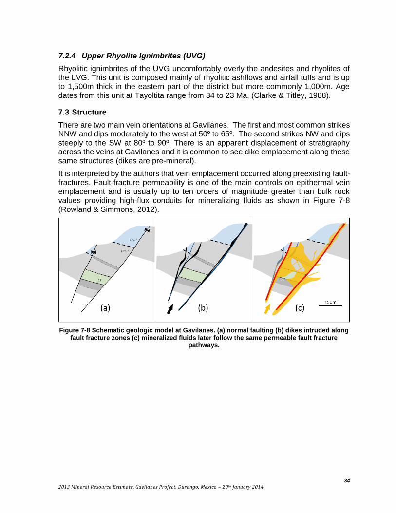
It is interpreted by the authors that vein emplacement occurred along preexisting fault-fractures. Fault-fracture permeability is one of the main controls on epithermal vein emplacement and is usually up to ten orders of magnitude greater than bulk rock values providing high-flux conduits for mineralizing fluids as shown in Figure 7-8 (Rowland & Simmons, 2012).
Figure 7-8 Schematic geologic model at Gavilanes. (a) normal faulting (b) dikes intruded along fault fracture zones (c) mineralized fluids later follow the same permeable fault fracture
pathways.

35
2013 Mineral Resource Estimate, Gavilanes Project, Durango, Mexico – 20th January 2014
7.4 Mineralization
Silver, base metal and gold mineralization at Gavilanes is hosted by crustiform-banded quartz veins, quartz vein stockworks, and breccia veins hosted within the andesites of the LVG. The veins are oriented NNW and NW and dip moderately to the W-SW. Veins pinch and swell, varying from < 3cm to 14m wide and averaging 3.5m. Vein contacts are frequently not sharp and there is generally an abundant wallrock component to the veins. Some of the veins have a strike length of over two kilometers. Average grades and the mineralized vertical interval (open at depth) are shown in Figure 7-9. The dominant ore minerals include native silver, argentite, sphalerite, galena, and chalcopyrite with gangue minerals including quartz, pyrite, K-feldspar, chlorite, epidote, sericite, calcite, barite and ilmenite.
Figure 7-9 Average vein grades and mineralized interval.
36
2013 Mineral Resource Estimate, Gavilanes Project, Durango, Mexico – 20th January 2014
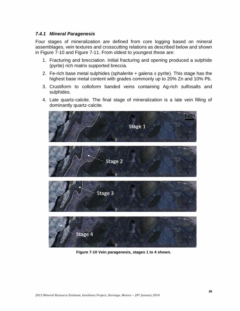
7.4.1 Mineral Paragenesis
Four stages of mineralization are defined from core logging based on mineral assemblages, vein textures and crosscutting relations as described below and shown in Figure 7-10 and Figure 7-11. From oldest to youngest these are:
1. Fracturing and brecciation. Initial fracturing and opening produced a sulphide (pyrite) rich matrix supported breccia.
2. Fe-rich base metal sulphides (sphalerite + galena ± pyrite). This stage has the highest base metal content with grades commonly up to 20% Zn and 10% Pb.
3. Crustiform to colloform banded veins containing Ag-rich sulfosalts and sulphides.
4. Late quartz-calcite. The final stage of mineralization is a late vein filling of dominantly quartz-calcite.
Figure 7-10 Vein paragenesis, stages 1 to 4 shown.

37
2013 Mineral Resource Estimate, Gavilanes Project, Durango, Mexico – 20th January 2014
Figure 7-11 Core photos showing mineral paragenesis. Numbers shown correspond to vein stages.
7.4.2 Alteration
Hydrothermal alteration is generally moderately developed around the veins with propylitic alteration extending commonly 10’s of metres from the vein. Alteration grades from propylitic into argillic alteration adjacent to the vein as shown in Figure 7-12. Typical mineral alteration assemblages are (from distal to proximal):
Hematite – thin envelops to pervasive alteration, thought to be related to oxidation of pyrite as fluids were first introduced, generally unmineralized.
Chlorite ± epidote ± sericite – moderate chlorite alteration with minor epidote and occasional sericite.
Silica-chlorite±illite – pervasive chlorite alteration with variable moderate to strong silicification ± illite.
Crustiform to colloform quartz vein and vein breccia

38
2013 Mineral Resource Estimate, Gavilanes Project, Durango, Mexico – 20th January 2014
Figure 7-12 Idealized section showing alteration.
7.5 Geologic Model
A 3D geologic model was built for the resource estimate using Leapfrog Geo software based on the authors’ interpretations during their site visit. Three domain types were used for the resource estimate, these are:
1. Vein Mineralization
Three vein structures at Gavilanes were modeled separately (Guadalupe-GP, Descubridora-DS and San Nicolas-SN). There were no true vein intersections in the San Nicolas structure, so no SN vein domain was created. Table 14-1 shows the average metal contents of the individual veins. The vein domains includes colloform / crustiform veining and vein breccia. In rare cases, grade was used to help define the contacts. Veins widths range from 0.2 to 13 m with an average width of 3m.

39
2013 Mineral Resource Estimate, Gavilanes Project, Durango, Mexico – 20th January 2014
2. Hangingwall (HW) / Footwall (FW) Mineralization
Mineralization extends from 0.7 to 40 metres into the hanging and footwall of the veins with an average of 7 metres. Typically, grades are associated with small (<5mm) veinlets and disseminated mineralization. Alteration, veinlet intensity and grades were the main criteria used to define the domain boundaries. All three vein structures had Hangingwall / footwall mineralization modeled.
3. Stockwork Mineralization (stx)
The stockwork zone consists of stockwork veinlets and occasional local wall rock breccia. Rare small discrete veins within the stockwork zone were included in this domain. The stockwork zone is located in a complex structural zone where the Guadalupe, Descubridora and San Nicolas vein structures intersect and may be related to a cymoidal loop structure (from Descubridora to Guadalupe veins). Stockwork domain width ranges from 10 to 170 metres with an average of 70 meters.
Geologic domains were determined from core logging by the authors and given a “from-to” based on the closest sampled interval “from-to”. If the interval was not sampled the “from-to” metres were measured from the core box. The domain interval file was used in Leapfrog to construct 3-dimensional solids of the domains. Due to the lack of detailed mapping of the historic mines and lack of drilling close to surface, the Vein and HW/FW domains were projected only to the lowest elevation of the historic mining (2125m elevation). The Stockwork domain and a small part of the Descubridora vein were projected to surface. The domains grade characteristics are described in more detail in Section 14 and are shown on cross-section in Appendix 4 – Drill hole cross-sections.
The topographic digital terrain model (DTM) used in the model was constructed by the author based on data obtained from the U.S. Geological Survey’s National Elevation Dataset (NED). For the Gavilanes area the only dataset available was the 1 arc-second (roughly 30 meters) spatial resolution dataset. Due to the poor resolution over the Gavilanes area this dataset was modified by adding survey data points collected by Santacruz. This included all drillhole elevations and all survey points (to sub-centimeter accuracy). The topography is adequate for this resource estimate as in most cases the domains are clipped well below the surface (at the base of historic mining, 2125m elevation). A better resolution elevation model will be required as the project advances.
8 DEPOSIT TYPE
Based on geologic setting, vein textures, mineralogy and alteration assemblages, mineralization at Gavilanes can be classified as an Intermediate Sulphidation Epithermal (IS) deposit (Hedinquist et al, 2000; Sillitoe & Hedinquist, 2003, Simmons et al, 2005). IS deposits form in the shallow parts of high-temperature hydrothermal systems that commonly develop in volcanic arcs. Depths are typically <1.5km with temperatures between 150º to 300ºC. It is thought that IS deposits have a higher

40
2013 Mineral Resource Estimate, Gavilanes Project, Durango, Mexico – 20th January 2014
contribution of magmatic derived fluids (higher salinities) compared to the more common Low Sulphidation Epithermal deposits. These more saline hydrothermal solutions have no modern counterpart in analogous active hydrothermal systems (Simmons et al, 2005).
The presence of chalcopyrite, FeS-poor sphalerite and the lack of aresenopyrite and pyrrhotite are used to define the sulphidation state at Gavilanes (Figure 8-1a). In addition, the high Ag/Au ratio (700-17,000), moderate sulphide abundance (5-15%) and crustiform quartz seen at Gavilanes are all key characteristics of IS deposits.
Another characteristic of IS deposits are the moderate salinity fluids responsible in part for the high base metal contents of these types of deposits (typically between 5 to 20 wt% NaCl). Metal contents can be used to estimate fluid salinities (no fluid inclusion studies have been done at Gavilanes) – with higher Ag/Au ratios related to higher salinities. The high Ag/Au ratios at Gavilanes correlate with salinities of around 10-15 wt % NaCl (Albison et al, 2003). Silver and base metals are transported as chloride complexes - with higher salinity and lower pH promoting metal dissolution as shown in Figure 8-1b (Henley, 1985).
Figure 8-1 (a) Sulphide assemblages and sulphidation state. Blue line highlights chalcopyrite (cp) and pyrrhotite stability fields, red circle highlights Gavilanes location on diagram (modified from Sillitoe & Hedinquist, 2003) (b) relationship between salinity and metal
solubility (from Henley, 1985).
In consideration of the alteration mineral assemblages, ore mineralogy, structural controls, and host rocks, the Gavilanes Project has many similarities to large IS deposits in Mexico including Fresnillo, Batopilas, Topia, Bolanas, and others worldwide including Kushikino, Japan, and Selene Peru.

41
2013 Mineral Resource Estimate, Gavilanes Project, Durango, Mexico – 20th January 2014
9 EXPLORATION
Exploration conducted before 2010 is discussed in Section 6, History and Section 10, Drilling. In summary, very little modern exploration was conducted on the property prior to 2010. Since 2010, Santacruz has taken 140 surface samples and 31 underground samples. Surface samples collected were taken along the known veins in a 4 km2 area surrounding the resource area. Samples were typically chip-grab or channel samples and are representative of the areas sampled. These samples were used to help define the geological model but were not used in the resource estimation. Surface sampling shows mineralized veins outcropping at least 2 km to the west of the current resource area. More sampling and mapping is warranted given the encouraging results of the surface sampling to date. The sampling is summarized in Table 9-1 and shown in Figure 9-1. The main resource area has been mapped at approximately 1:50,000 scale as shown in Figure 7-2.
Table 9-1 Summary of surface and underground samples taken since 2010 by Santacruz.
Vein Number of Samples
Ag (g/t) Range
Ag (g/t) Average
Au (g/t) Range
Au (g/t) Average
La Cruz 57 1-398 43 <0.005-4.05 0.73
Guadalupe 37 0.1-2870 1440 <0.005-1.9 0.95
Descubridora 24 1.6-694 225 <0.005-4.65 1.07
San Nicolas 16 1.4-683 107 <0.005-1.37 0.06
El Muerto 4 23.4-1135 431.6 <0.005-1.18 0.42
La Tuna 2 794-1820 1307 0.374-1.14 0.75
Guadalupe Mine 31 4-483 173 <0.005-0.2 0.03

42
2013 Mineral Resource Estimate, Gavilanes Project, Durango, Mexico – 20th January 2014
Figure 9-1 Surface sampling - resource footprint and drilling shown for reference
43
2013 Mineral Resource Estimate, Gavilanes Project, Durango, Mexico – 20th January 2014
10 DRILLING
10.1 Historic Drilling
In the 1980’s Dr. Torre drilled 4 core holes as listed in Table 10-1. No data from this drilling was supplied to the authors. These holes were not used in the current resource estimate.
Table 10-1 Drilling by Torre in the 1980's
Hole ID Vein N_NAD27 E_NAD27 Az DIP Depth
GPE-01 Guadalupe 2678712 425620 78 -54 97.6
GPE-02 Guadalupe 2678712 425620 78 -15 137
GPE-03 Guadalupe 2678605 425643 55 -20 161
B1AT Guadalupe 2678328 425545 88 -25 145.5
In 2008, Hochschild drilled 10 core holes for a total of 2,847.35 metres as listed in Table 10-2 (shown in Figure 9-1). Only a summary table of intercepts and assays from holes HGVG-01 and HGVG-02 were supplied to the authors (Table 10-3). No certificates or geology logs were available for any holes. Due to the lack of data, no historic drilling was used in this resource estimation.
Table 10-2 Drilling by Hochschild in 2008
Hole ID Vein N_NAD27 E_NAD27 Az Dip Depth
HGVG-01 Guadalupe 2678412 425506 90 -60 280.55
HGVG-02 Guadalupe 2678479 425557 85 -60 315.20
HGVG-03 Guadalupe 2678810 425518 95 -60 333.05
HGVG-04 Guadalupe 2678810 425518 83 -55 399.35
HGVG-05 Providencia 2679123 425277 42 -50 284.25
HGVG-06 Guadalupe 2678408 425507 120 -80 356.60
HGVC-01 La Cruz 2678278 424527 90 -55 274.20
HGVT-01 La Cruz 2678435 424635 90 -50 166.65
HGVT-02 La Cruz 2678435 424635 90 -55 237.40
HGVT-03 La Cruz 2678562 424874 90 -50 200.10
Table 10-3 Hochschild drilling significant intercepts (all lengths in metres)
Vein Hole From To Width (m)
Au (g/t)
Ag (g/t)
Pb (%)
Zn (%)
Cu (%)
Guadalupe HGVG-01 119.1 123.3 4.2 0 190 0.21 0.19 0.03
Guadalupe HGVG-01 214.66 215.8 1.14 0.65 102 8.51 4.96 1.19
Guadalupe HGVG-02 174.54 176.15 1.61 0.52 171 2.82 4.2 0.39
Guadalupe HGVG-03 203.44 204.97 1.53 0.03 80 0.2 0.3 -
Guadalupe HGVG-03 221.72 225.3 3.58 0.03 3 0 0 -
Guadalupe HGVG-04 169.8 175.9 6.1 0.03 3 0 0 -
Guadalupe HGVG-04 295.1 299.59 4.49 0.03 2 0.15 0.22 -
Guadalupe HGVG-04 300.56 301.68 1.12 0.08 20 0.94 1.02 -
Guadalupe HGVG-05 210.2 235.6 25.4 0.03 4 0 0 -

44
2013 Mineral Resource Estimate, Gavilanes Project, Durango, Mexico – 20th January 2014
Vein Hole From To Width (m)
Au (g/t)
Ag (g/t)
Pb (%)
Zn (%)
Cu (%)
Guadalupe HGVG-06 67.5 68.35 0.85 0.2 556 0.71 1.14 0.42
Guadalupe HGVG-06 129.6 141.2 11.6 0.03 28 0.24 0.15 0
Guadalupe HGVG-06 149.85 156.65 6.8 0.05 20 0.06 0.03 0
Guadalupe HGVG-06 218.35 220.05 1.7 0.03 187 0.29 0.13 0.2
La Cruz HGVC-01 44.9 51 6.1 0.03 2 0 0 -
La Cruz HGVT-02 68.1 72.5 4.4 0.05 5 0.13 0 -
La Cruz HGVT-03 94.1 97.75 3.65 0.03 9 0 0 -
10.2 Santacruz Drilling
Drilling began at Gavilanes by Santacruz in August 2012 with 9,623.9 metres of HQ core drilled to July 2013 in 47 holes. There has been no drilling on the property since then. Table 10-4 gives a summary of the metres drilled on each vein. Drill hole locations and orientation are given in Appendix 1. The drill contractor was AP Explore Drilling S.A. de C.V. of Oaxaca, Mexico.
Downhole surveys were taken by the drill contractor with a REFLEX instrument approximately every 50 metres where possible. The precision of this instrument is 0.1º in azimuth and dip, field accuracy is estimated to be ±1-2º. All drill hole collars were surveyed by a Santacruz surveyor using a total station to decimeter accuracy.
Core recovery varies by location and ranges from 16 to 100% with an average of 98% (4 samples had recovery less than 25%, 16 less than 50%, and 39 less than 75% out of a total of 3,362 samples). There is no evidence that the low recovery samples are not representative of the intervals being drilled and have been used in the resource estimate. Section 11 discusses the sampling protocol used. The sampling interval was based on visual inspection of core by the geologist. Sample size range was 20cm to a maximum of 3.6m; average sample size was 1m. A total of 3362 samples were taken from core (excluding QAQC samples).
Table 10-4 Santacruz drilling by vein
Vein Holes Meters
Guadalupe 30 5,778
San Nicolas 5 1,141.5
Descubridora 12 2,704.4
Drill hole locations are shown in Figure 10-1. The drill program was designed to test three areas, the Guadalupe, Descubridora, and San Nicolas veins.
Significant intercepts are summarized in Table 10-5, Table 10-6 (values are as publically released by Santacruz) and Table 10-7. The intercepts in these tables were not used in the resource estimate. The resource estimate used composites from the original sample assays as described in Section 14.2. Drill hole cross-sections are shown in Appendix 4 – Drill hole cross-sections.

45
2013 Mineral Resource Estimate, Gavilanes Project, Durango, Mexico – 20th January 2014
Figure 10-1 Gavilanes drill plan with surface samples
N

46
2013 Mineral Resource Estimate, Gavilanes Project, Durango, Mexico – 20th January 2014
Table 10-5 Guadalupe Vein significant drill intercepts (all lengths in metres)
Hole From To Length True
Width Au (g/t) Ag (g/t) Cu (%) Pb (%) Zn (%)
SCGP-01 86 91.2 5.2 5 0.12 188 0.05 0.86 0.75
SCGP-02 94 101.2 7.2 6.5 0.15 184 0.06 2.51 2.03
SCGP-03 186.6 187.85 1.25 1.18 0.02 845 0.02 0.13 0.13
SCGP-03 190.35 191.4 1.05 0.99 0.02 544 0.01 0.28 0.45
SCGP-03 196 199.2 3.2 3.02 0 137 0 0.16 0.08
SCGP-03 205.8 210.6 4.8 4.53 0.19 102 0.08 0.88 0.58
SCGP-03 218.85 221.55 2.7 2.55 0.25 115 1.13 0.88 0.51
SCGP-04 154.95 160.3 5.35 2.67 0 200 0.02 0.14 0.05
SCGP-04 169.15 173.75 4.6 3.78 0.16 156 0.17 1.01 0.5
SCGP-04 234.35 235.85 1.5 1.25 1.07 132.4 0.69 3.38 1.87
SCGP-05 162.3 164 1.7 1.65 0.12 78.92 0.2 0.76 1.22
SCGP-05 167.25 168.5 1.25 1.21 0.08 70.98 0.08 0.31 0.66
SCGP-06 127.4 129.4 2 1.85 0.01 123 0.11 0.18 0.18
SCGP-07 124.95 127.4 2.45 2.1 0 128 0.02 0.04 0.07
SCGP-07 204.4 207.65 3.25 2.8 0.09 167 0.01 0.08 0.04
SCGP-08 189 190.4 1.4 1.2 0.18 53.1 0.18 0.19 0.3
SCGP-09 149.75 157.95 8.2 7.4 0.34 256 0.13 1.5 1.92
SCGP-11 115.8 118.05 2.25 1.92 0 167 0.01 0.45 0.38
SCGP-12 55.95 59.9 3.95 3.82 0.23 243 0.01 0.32 0.21
SCGP-13 63.5 66 2.5 2.25 0.1 208 0.06 1.26 1.21
SCGP-14 88.1 89.2 1.1 1.05 0 180 0.02 1.21 0.58
SCGP-14 93.7 97.15 3.45 3.35 0 103 0.01 0.12 0.08
SCGP-15 95.55 99.05 3.50 3.15 0.12 76 0.03 0.78 0.98
SCGP-15 113.05 116.4 3.35 3.05 0 298 0.02 0.7 0.58
SCGP-16 117.3 117.5 0.2 0.12 0.03 48 0.04 2.17 5.26
SCGP-17 101.95 108.7 6.75 5.25 0.41 109 0.07 0.55 1.88
SCGP-18 131.65 132.65 1 0.65 2.39 106 0.39 1.88 1.22
SCGP-19 89 90.8 1.8 1.65 0 33 0 0.11 0.24
SCGP-20 106.85 108.3 1.45 1.25 0.02 145 0 0.18 0.28
SCGP-20 132.9 133.7 0.8 0.7 0.06 115 0.01 2.97 13.03
SCGP-21 109 111 2 1.55 0.72 212 0.32 3.97 8.09
SCGP-22 51.65 61.65 10 8.25 0.85 121 0.12 0.76 0.68
SCGP-22 109.75 113 3.25 2.75 0.03 2540 0.02 0.12 0.1
SCGP-22 164.65 166.95 2.3 2 0.29 306 0.77 8.73 0.23
SCGP-23 125.7 126.1 1.1 1.05 0.48 104 0.5 1.27 4.43
SCGP-24 174.85 177.25 2.4 1.4 0.3 147 0.03 0.03 0.09
SCGP-25 79.8 80.9 1.1 1.04 0.25 332 0.15 1.54 5.3
SCGP-26 107.25 109.65 2.4 2.3 0.12 121 0.12 2.55 2.73

47
2013 Mineral Resource Estimate, Gavilanes Project, Durango, Mexico – 20th January 2014
Hole From To Length True
Width Au (g/t) Ag (g/t) Cu (%) Pb (%) Zn (%)
SCGP-26 120.6 122.45 1.85 1.82 0 453 0 0.2 0.14
SCGP-27 117.5 121.2 3.7 2.96 0.42 344 0.19 4.72 10.01
SCGP-27 143.85 148.8 4.95 4.01 0.12 716 0.07 0.67 0.51
SCPV-01 146.2 148 1.8 1.7 0.02 143 0.03 0.22 0.51
SCPV-01 211.95 213.4 1.45 1.37 0.25 95 0.07 0.5 0.61
SCPV-01 237.55 239.05 1.5 1.42 0 532 0.02 0.77 0.69
Table 10-6 Descubridora Vein significant drill intercepts
Hole From To Length True
Width Au
(g/t) Ag (g/t) Cu (%) Pb (%) Zn (%)
SCHN-01 46.4 56.75 10.35 7.25 0.01 197 0.05 0.3 0.18
SCHN-01 62.9 65.75 2.85 2.05 0.01 279 0.06 0.47 0.13
SCHN-01 108.5 112.4 3.9 2.19 0 572 0.02 0.13 0.09
SCHN-01 119.85 126.05 6.2 4.46 0 178 0 0.19 0.06
SCHN-01 198.5 201.1 2.6 1.87 1.77 48 0.21 0.06 0.04
SCHN-01 206.85 217.8 10.95 7.88 1.46 201 1.45 1.29 0.23
SCHN-02 42.1 49.25 7.15 3 0.01 488 0.09 0.61 0.55
SCHN-02 99.35 106.5 7.15 3 0.03 128 0.21 5.65 0.26
SCHN-03 147.45 149 1.55 1.5 0 53 0.03 0.56 1.38
SCHN-04 50.55 57.45 6.9 6.7 0.08 582 0.04 0.2 0.22
SCHN-04 69.8 76.35 6.55 6.4 0 211 0.02 0.02 0.07
SCHN-04 113.85 115.85 2 1.91 0 840 0.02 0.03 0.03
SCHN-04 121.05 128.1 7.05 6.75 0.02 408 0.04 0.12 0.06
SCHN-04 190.95 193.85 2.9 2.75 0.18 160 0.02 0.14 0.07
SCHN-05 57.7 67.95 10.25 8.51 0.01 427 0.03 2.9 8.04
SCHN-07 113.4 126.85 13.45 4.7 0.03 212 0.14 1.13 1.18
SCHN-08 85.3 91.6 6.3 4.95 0.01 427 0.02 0.4 0.07
SCHN-08 120.05 123 2.95 2.3 0.2 120 0.05 1.91 0.04
SCHN-09 86.1 96.8 10.7 5.4 0.01 263 0.02 0.69 0.28
SCHN-12 61.65 73.6 11.95 7.25 0.02 325 0.07 0.34 0.3
SCHN-12 77.75 85.3 7.55 4.58 0.15 1687 0.05 0.34 1.03
SCHN-12 108.25 113.5 5.25 3.2 0.03 1048 0.03 0.14 0.26
Table 10-7 San Nicolas Vein significant drill intercepts
Hole From To Length True
Width Au
(g/t) Ag (g/t) Cu (%) Pb (%) Zn (%)
SCSN-04 81.20 91.45 10.25 6.15 0 427 0 0.38 0.34
SCSN-05 66.75 68.25 1.5 0.9 0.07 104 0 0.29 0.26

48
2013 Mineral Resource Estimate, Gavilanes Project, Durango, Mexico – 20th January 2014
11 SAMPLE PREPARATION, ANALYSES, AND SECURITY
The sample preparation and analytical techniques used were appropriate for the style of mineralization occurring at Gavilanes. The inserted standards and blanks and field duplicates do not indicate any problems with the analytical results.
The QAQC program should have included the use of more than one standard, including at least one at a higher silver grade. No routine sample preparation and laboratory check assays were performed. The authors are of the opinion that these deficiencies in the QAQC program are not a critical failure and that the sampling and analytical results are reliable and adequate for this resource estimation.
11.1 Sample Preparation and Analysis
Holes were drilled with HQ-sized core with only select intervals sampled. Core was sawn in half at site and one half sent to ALS, an independent, fully accredited and certified laboratory service - accredited by the International Organization for Standardization (ISO). Samples were prepared at the ALS facility in Zacatecas, Mexico, and were analysed at ALS in Vancouver, Canada. All samples were analysed using a one assay ton fire assay with an AA finish for Au (Au-AA23) and a 48 element ICP method for other elements (ME-MS61). Samples with silver results above 100 g/t by (ME-MS61) were rerun using an aqua regia digestion and ICP-AES or AAS finish (Ag-OG62). A QAQC procedure was followed using standards, blanks and duplicates. Santacruz sampling protocol recommends using 3 control samples per 20 samples, these being:
Field Blanks (AuBlank39)
Standards (SP49 & 66)
Field Duplicates
Table 11-1 Summary of control sample certified values (from Rocklabs)
Control Sample Mean Std Dev
AuBlank39 <0.002 g/t Au
SP49 60.2 g/t Ag 1.0
SP66 1.086 g/t Au 0.009 g/t
Analysis of the control samples (Table 11-1) are discussed below.
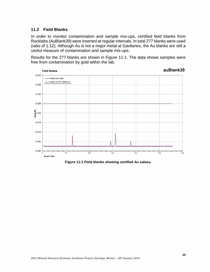
49
2013 Mineral Resource Estimate, Gavilanes Project, Durango, Mexico – 20th January 2014
11.2 Field Blanks
In order to monitor contamination and sample mix-ups, certified field blanks from Rocklabs (AuBlank39) were inserted at regular intervals. In total 277 blanks were used (ratio of 1:12). Although Au is not a major metal at Gavilanes, the Au blanks are still a useful measure of contamination and sample mix-ups.
Results for the 277 blanks are shown in Figure 11-1. The data shows samples were free from contamination by gold within the lab.
Figure 11-1 Field blanks showing certified Au values.

50
2013 Mineral Resource Estimate, Gavilanes Project, Durango, Mexico – 20th January 2014
11.3 Standards
Two standards were used, both from Rocklabs (SP49 & SG66). SG66 is an Au standard while SP49 is an Au and Ag standard. In total, a standard was used 99 times (1:34) to monitor lab accuracy.
Results from a total of 65 SP66 standards (Au certified value = 1.086 ppm) are shown in Figure 11-2. In total, accuracy is estimated at -1% (ALS vs certified value). There were 2 standards which returned values below acceptable limits - defined as ± 3 standard deviations (calculated from the data). No information was available to the authors on what was done with the two failed standards. However, only one of the failed samples was within the same assay allotment as mineralized vein interval (the other was in a low grade interval). The Ag values of the standard were similar to the average assayed value for that standard. Therefore, the two failed standards do not have a material impact on the estimation of a mineral resource.
There were 34 SP49 standards analyzed (Ag certified value = 60.2 ppm) as shown in Figure 11-3. Accuracy is estimated at -3.4%. All samples were within acceptable limits (defined as ± 3 standard deviations of the sample data).

51
2013 Mineral Resource Estimate, Gavilanes Project, Durango, Mexico – 20th January 2014
Figure 11-2 Au Standard SG66. Process limits are 3 x standard deviation of data.

52
2013 Mineral Resource Estimate, Gavilanes Project, Durango, Mexico – 20th January 2014
Figure 11-3 Ag Standard SG49

53
2013 Mineral Resource Estimate, Gavilanes Project, Durango, Mexico – 20th January 2014
11.4 Field Duplicates
Core was ¼ split to create duplicate samples. 178 duplicates were taken from a total of 3362 samples (1:19), Ag results are shown in Figure 11-4. The results are evenly scattered around the 1:1 line.
Figure 11-4 Field duplicates original vs duplicate (Ag), (a) all data, (b) samples <100 g/t Ag
The absolute difference between original and duplicate samples is shown in a cumulative frequency plot in Figure 11-5. Approximately 90% of the samples have less than 20% absolute relative difference from the original. The precision data is within normal ranges observed for epithermal deposits. The sample preparation and analytical techniques used were appropriate for the style of mineralization occurring at Gavilanes. The inserted standards and blanks and field duplicates do not indicate any problems with the analytical results.

54
2013 Mineral Resource Estimate, Gavilanes Project, Durango, Mexico – 20th January 2014
Figure 11-5 Field duplicates cumulative frequency plot for all metals

55
2013 Mineral Resource Estimate, Gavilanes Project, Durango, Mexico – 20th January 2014
11.5 Sample Security
Unauthorized personnel were not allowed in the core storage, logging or cutting facilities during the core logging and sampling process. Core for sampling was delivered directly to the core-cutting area or secure storage area before cutting. Lids were kept on boxes during transfer. The core storage area has a fulltime caretaker who lives on site.
Once cut, the samples were bagged and labeled and assembled into batch shipments. These were stored in sealed sacks. The batches were delivered to the ALS lab in Zacatecas along with sample submission forms by Santacruz staff.
12 DATA VERIFICATION
Smit and Bourke conducted an on-site visit to Gavilanes from the 20th to 25th of October 2013. Thirty-six of the total 47 holes drilled by Santacruz were re-logged by the authors. During this time, the Santacruz logging and results from ALS were also checked while visually inspecting the core. The logging by the authors was used to construct the domain model for the resource estimate as described in Section 7.5. The sample intervals with high metal results could all be explained by the presence of alteration and/or veining.
In addition, the authors took 4 independent samples from core while re-logging. After watching the samples being cut, the samples were handled and bagged (sealed bag) by the authors. The samples remained in the authors’ control and were personally delivered to DHL in Durango City for shipment to ALS in Hermosillo. Analysis was the same used by Santacruz. Results are shown in Table 12-1. Results are within acceptable limits.
Table 12-1 Check samples taken by author vs Santacruz (SC) results
Sample SC Sample
SC Ag (g/t)
Ag (g/t)
SC Au (g/t)
Au (g/t)
SC Zn (%)
Zn (%) SC Pb (%)
Pb (%)
SC Cu (%)
Cu (%)
12655 2655 282 261 2.74 2.33 0.1 0.1 0.66 0.41 1.53 1.56
13105 3105 110 135 0.03 0.05 0.19 0.23 0.21 0.25 0.02 0.02
15454 5454 1460 1090 0.01 0.02 0.20 0.17 0.45 0.22 0.01 0.01
15988 5988 4.99 4.62 7.84 4.54 0.02 0.02 0.02 0.02 0.01 0.01
A new independent, assay database was created by Bourke by importing certificates directly from ALS for all drill hole assays. This was used in the resource estimate. The database assay results were then randomly spot checked against the original pdf ALS certificate. No discrepancies were found.
Hole collar locations and strike and dip data were checked in the field by the authors by compass and handheld GPS. In total, 17 drill holes were visited and re-surveyed. No errors were found in the collar locations or orientation. In addition, mine workings and geologic mapping of the vein outcrops (including strike and dips from outcrop) were verified against mapping by Santacruz.

56
2013 Mineral Resource Estimate, Gavilanes Project, Durango, Mexico – 20th January 2014
Although the drilling by Hochschild was unable to be used in the current resource estimate due to lack of data, the assay results were compared on section to any surrounding Santacruz drill holes with no obvious bias or error noted.
In the authors’ opinion, the data used for the resource calculation presented in this report was of high quality and adequate for the purpose.
13 MINERAL PROCESSING AND METALLURGICAL TESTING
No metallurgical test work has been done on any of the material at Gavilanes by Santacruz. No recovery information from past operations was made available to the authors.

57
2013 Mineral Resource Estimate, Gavilanes Project, Durango, Mexico – 20th January 2014
14 MINERAL RESOURCE ESTIMATE
Giroux Consultants Ltd. was contracted by Santacruz Silver Mining Ltd. to complete a resource estimate for the Gavilanes Project located in San Dimas Municipality, 130 km southwest of Durango City, Mexico. The resources were estimated by Gary Giroux, P.Eng. MASc. who is a Qualified Person and independent of both the issuer and the title holder, based on the tests outlined in NI 43-101.
The current resource area of the Gavilanes Project is comprised of three separate mineralized structures: the Guadalupe (GP), the Desubridora (DS) and the San Nicolas (SN). Contained within these structures is a stockwork zone (see Figure 14.1). The Guadalupe and the Desubridora zones consist of a central high-grade vein surrounded by lower grade hanging wall and foot wall mineralization. No vein intercepts have been intersected, at this time, on the San Nicolas structure.
Figure 14-1 Generalized Cross Section looking NW showing Mineralized Structures
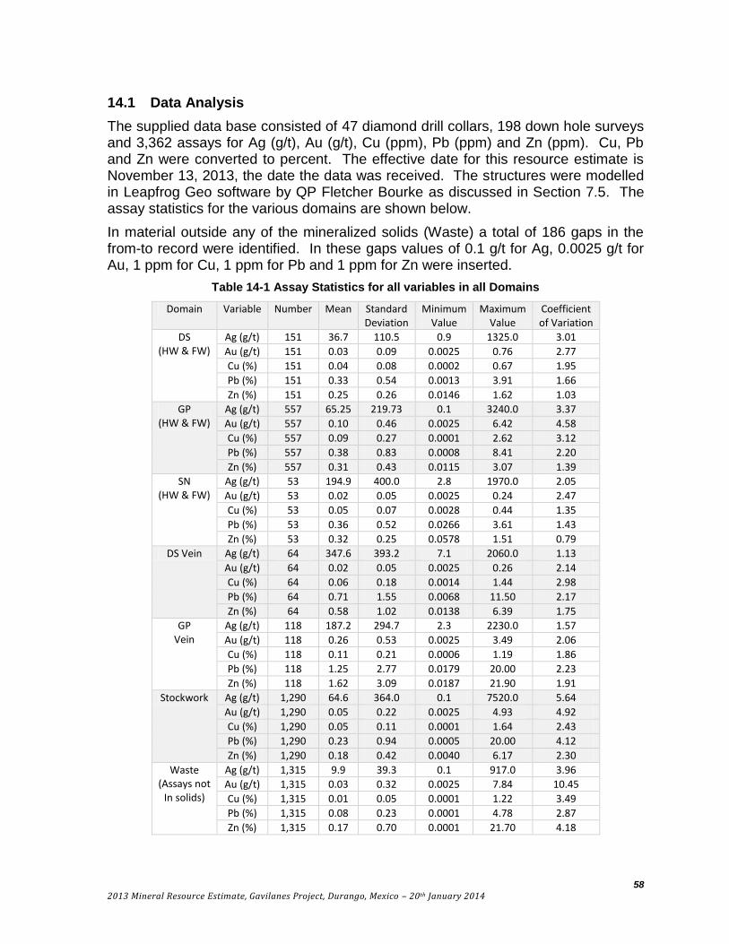
58
2013 Mineral Resource Estimate, Gavilanes Project, Durango, Mexico – 20th January 2014
14.1 Data Analysis
The supplied data base consisted of 47 diamond drill collars, 198 down hole surveys and 3,362 assays for Ag (g/t), Au (g/t), Cu (ppm), Pb (ppm) and Zn (ppm). Cu, Pb and Zn were converted to percent. The effective date for this resource estimate is November 13, 2013, the date the data was received. The structures were modelled in Leapfrog Geo software by QP Fletcher Bourke as discussed in Section 7.5. The assay statistics for the various domains are shown below.
In material outside any of the mineralized solids (Waste) a total of 186 gaps in the from-to record were identified. In these gaps values of 0.1 g/t for Ag, 0.0025 g/t for Au, 1 ppm for Cu, 1 ppm for Pb and 1 ppm for Zn were inserted.
Table 14-1 Assay Statistics for all variables in all Domains
Domain Variable Number Mean Standard Deviation
Minimum Value
Maximum Value
Coefficient of Variation
DS (HW & FW)
Ag (g/t) 151 36.7 110.5 0.9 1325.0 3.01
Au (g/t) 151 0.03 0.09 0.0025 0.76 2.77
Cu (%) 151 0.04 0.08 0.0002 0.67 1.95
Pb (%) 151 0.33 0.54 0.0013 3.91 1.66
Zn (%) 151 0.25 0.26 0.0146 1.62 1.03
GP (HW & FW)
Ag (g/t) 557 65.25 219.73 0.1 3240.0 3.37
Au (g/t) 557 0.10 0.46 0.0025 6.42 4.58
Cu (%) 557 0.09 0.27 0.0001 2.62 3.12
Pb (%) 557 0.38 0.83 0.0008 8.41 2.20
Zn (%) 557 0.31 0.43 0.0115 3.07 1.39
SN (HW & FW)
Ag (g/t) 53 194.9 400.0 2.8 1970.0 2.05
Au (g/t) 53 0.02 0.05 0.0025 0.24 2.47
Cu (%) 53 0.05 0.07 0.0028 0.44 1.35
Pb (%) 53 0.36 0.52 0.0266 3.61 1.43
Zn (%) 53 0.32 0.25 0.0578 1.51 0.79
DS Vein Ag (g/t) 64 347.6 393.2 7.1 2060.0 1.13
Au (g/t) 64 0.02 0.05 0.0025 0.26 2.14
Cu (%) 64 0.06 0.18 0.0014 1.44 2.98
Pb (%) 64 0.71 1.55 0.0068 11.50 2.17
Zn (%) 64 0.58 1.02 0.0138 6.39 1.75
GP Vein
Ag (g/t) 118 187.2 294.7 2.3 2230.0 1.57
Au (g/t) 118 0.26 0.53 0.0025 3.49 2.06
Cu (%) 118 0.11 0.21 0.0006 1.19 1.86
Pb (%) 118 1.25 2.77 0.0179 20.00 2.23
Zn (%) 118 1.62 3.09 0.0187 21.90 1.91
Stockwork Ag (g/t) 1,290 64.6 364.0 0.1 7520.0 5.64
Au (g/t) 1,290 0.05 0.22 0.0025 4.93 4.92
Cu (%) 1,290 0.05 0.11 0.0001 1.64 2.43
Pb (%) 1,290 0.23 0.94 0.0005 20.00 4.12
Zn (%) 1,290 0.18 0.42 0.0040 6.17 2.30
Waste (Assays not
In solids)
Ag (g/t) 1,315 9.9 39.3 0.1 917.0 3.96
Au (g/t) 1,315 0.03 0.32 0.0025 7.84 10.45
Cu (%) 1,315 0.01 0.05 0.0001 1.22 3.49
Pb (%) 1,315 0.08 0.23 0.0001 4.78 2.87
Zn (%) 1,315 0.17 0.70 0.0001 21.70 4.18

59
2013 Mineral Resource Estimate, Gavilanes Project, Durango, Mexico – 20th January 2014
Table 14-2 Pearson Correlation Matrix for each Domain
Domain Variable Ag Au Cu Pb Zn
DS (HW & FW)
Ag 1.0000
Au 0.1150 1.0000
Cu 0.3370 0.3723 1.0000
Pb 0.4096 0.4413 0.1667 1.0000
Zn 0.4832 0.3468 0.2081 0.7107 1.0000
GP (HW & FW)
Ag 1.0000
Au 0.3233 1.0000
Cu 0.4130 0.7123 1.0000
Pb 0.6208 0.2622 0.3655 1.0000
Zn 0.4873 0.1157 0.1818 0.7548 1.0000
SN (HW & FW)
Ag 1.0000
Au 0.1983 1.0000
Cu 0.4798 0.5252 1.0000
Pb 0.2723 0.0848 0.2439 1.0000
Zn 0.0999 0.2437 0.1700 0.5200 1.0000
DS Vein
Ag 1.0000
Au 0.4020 1.0000
Cu 0.3158 0.5933 1.0000
Pb 0.3373 0.3499 0.5650 1.0000
Zn 0.1955 0.2964 0.4897 0.7444 1.0000
GP Vein
Ag 1.0000
Au 0.4912 1.0000
Cu 0.5431 0.7339 1.0000
Pb 0.5237 0.5869 0.6786 1.0000
Zn 0.3810 0.4864 0.5212 0.7980 1.0000
Stockwork
Ag 1.0000
Au 0.3674 1.0000
Cu 0.4115 0.4443 1.0000
Pb 0.5935 0.2320 0.3318 1.0000
Zn 0.4613 0.2478 0.2821 0.7257 1.0000
Waste (Assays not
In solids)
Ag 1.0000
Au 0.2759 1.0000
Cu 0.5332 0.4370 1.0000
Pb 0.7211 0.1547 0.4159 1.0000
Zn 0.6741 0.1345 0.3741 0.8750 1.0000
All variables within all domains formed lognormal distributions and as a result the log values were used to produce a Pearson Correlation Matrix for each domain. Lead is well correlated with zinc in all domains except SN (HW-FW material) where it is reasonably correlated. In both the GP Vein material and GP (HW-FW material) Cu is well correlated with Au and Ag is reasonably correlated with Pb. When comparing the two veins (DS Vein vs. GP Vein), the five variables are better correlated in the GP Vein. The relationship between variables in each domain can also be shown graphically on a dendrograph. The dendrograph (McCannon and Wenninger, 1970;

60
2013 Mineral Resource Estimate, Gavilanes Project, Durango, Mexico – 20th January 2014
McCammin, 1968; Bentzen and Sinclair, 2000) is a graphical method of clustering that depends on the correlation coefficients. Figure 14.2 show these graphs for each of the mineralized domains with the variables on the x axis and the correlation coefficients on the y axis.
The hanging wall – footwall material surrounding the DS vein shows a Pb–Zn cluster best correlated with Au and weak relationships to Cu and Ag.
The hanging wall – footwall material surrounding the GP vein on the other hand shows a Pb–Zn cluster best correlated with Ag and a separate Au–Cu cluster.
The material within the SN structure shows a similar relationship to the GP HW-FW with a Au–Cu cluster and a Pb–Zn cluster both loosely correlated with Ag.
The DS vein shows a Pb–Zn cluster loosely correlated with first Cu, then Au and finally Ag.
The GP vein shows a similar pattern to the GP HW-FW material with a Au–Cu cluster and a Pb–Zn cluster both loosely correlated to Ag.
Finally the Stockwork mineralization shows the same pattern as the GP vein, only with lower correlation coefficients.
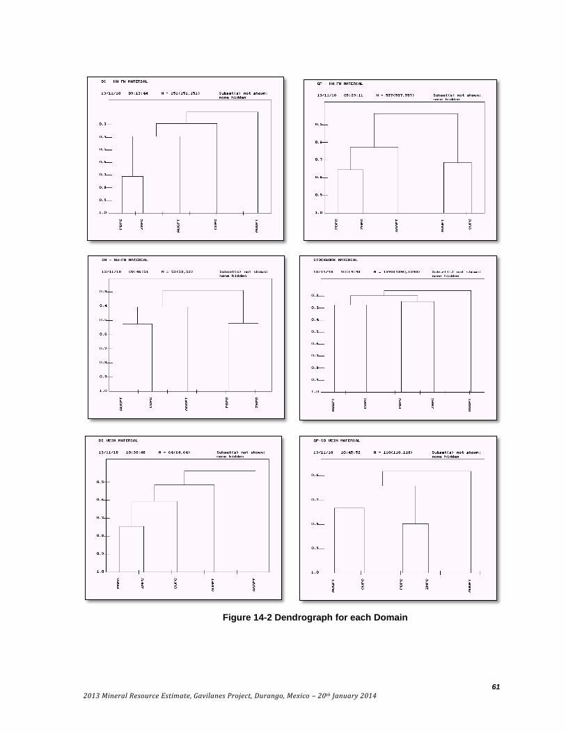
61
2013 Mineral Resource Estimate, Gavilanes Project, Durango, Mexico – 20th January 2014
Figure 14.2: Dendrograph for each Domain Figure 14-2 Dendrograph for each Domain

62
2013 Mineral Resource Estimate, Gavilanes Project, Durango, Mexico – 20th January 2014
To determine if capping was required within each domain, the grade distribution for each variable was examined using lognormal cumulative frequency plots. The procedure used is explained in a paper by Dr. A.J. Sinclair titled Applications of probability graphs in mineral exploration (Sinclair, 1976). In short the cumulative distribution of a single normal distribution will plot as a straight line on probability paper while a single lognormal distribution will plot as a straight line on lognormal probability paper. Overlapping populations will plot as curves separated by inflection points. Sinclair proposed a method of separating out these overlapping populations using a technique called partitioning. In 1993 a computer program called P-RES was made available to partition probability plots interactively on a computer (Bentzen and Sinclair, 1993). Screen dumps from this program are shown for silver in the DS HW-FW and GP HW-FW Domains in Figures 14.3 and 14.4. In each Figure the actual data distribution is shown as black dots. The inflection points that separate the populations are shown as vertical lines and each population is shown by the straight lines of open circles. The interpretation is tested by recombining the data in the proportions selected and the test is shown as triangles compared to the original distribution. Silver in each domain is examined in the following section with the populations broken out and thresholds selected for capping if required.
Figure 14-3 Lognormal cumulative frequency plot for Ag in DS HW-FW domain
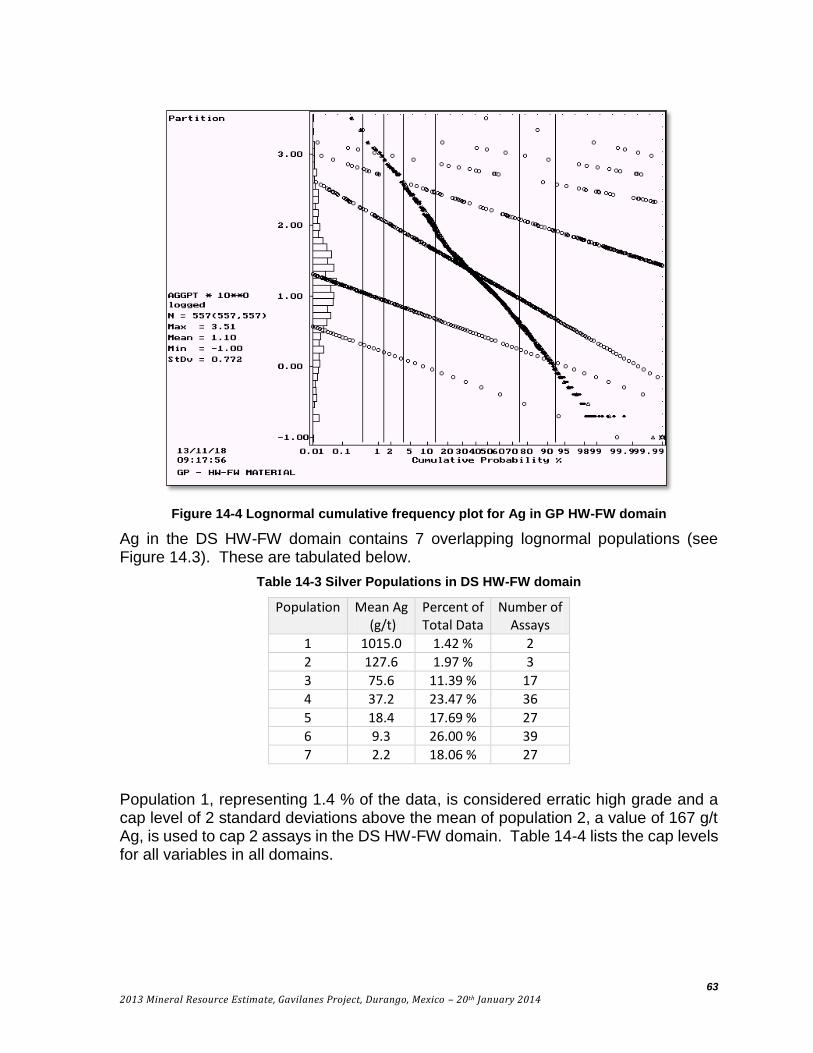
63
2013 Mineral Resource Estimate, Gavilanes Project, Durango, Mexico – 20th January 2014
Figure 14-4 Lognormal cumulative frequency plot for Ag in GP HW-FW domain
Ag in the DS HW-FW domain contains 7 overlapping lognormal populations (see Figure 14.3). These are tabulated below.
Table 14-3 Silver Populations in DS HW-FW domain
Population Mean Ag (g/t)
Percent of Total Data
Number of Assays
1 1015.0 1.42 % 2
2 127.6 1.97 % 3
3 75.6 11.39 % 17
4 37.2 23.47 % 36
5 18.4 17.69 % 27
6 9.3 26.00 % 39
7 2.2 18.06 % 27
Population 1, representing 1.4 % of the data, is considered erratic high grade and a cap level of 2 standard deviations above the mean of population 2, a value of 167 g/t Ag, is used to cap 2 assays in the DS HW-FW domain. Table 14-4 lists the cap levels for all variables in all domains.

64
2013 Mineral Resource Estimate, Gavilanes Project, Durango, Mexico – 20th January 2014
Table 14-4 Capping Levels for all Domains
Domain Ag (g/t) Au (g/t) Cu (%) Pb (%) Zn (%)
Cap Level
Number Capped
Cap Level
Number Capped
Cap Level
Number Capped
Cap Level
Number Capped
Cap Level
Number Capped
DS- HW/FW 167.0 2 0.57 2 0.39 2 2.20 2 1.00 2 GP-HW/FW 1600.0 2 2.40 4 2.20 2 6.20 3 2.70 4 SN-HW/FW 896.0 4 0.15 4 0.20 2 1.20 2 0.90 2 Stockwork 2318.0 5 2.10 2 0.64 7 9.00 3 2.50 7
DS Vein 1365.0 2 0.20 2 0.13 4 2.80 2 3.20 1 GP Vein 1000.0 2 1.40 4 0.63 4 11.00 2 13.70 2 Waste 71.0 29 0.20 20 0.20 13 0.60 33 0.70 50
Table 14-5 lists the results after capping.
Table 14-5 Capped Assay Statistics for all variables in all Domains
Domain Variable Number Mean Standard Deviation
Minimum Value
Maximum Value
Coefficient of Variation
DS (HW & FW)
Ag (g/t) 151 28.5 31.7 0.9 167.0 1.11
Au (g/t) 151 0.03 0.08 0.0025 0.57 2.60
Cu (%) 151 0.04 0.07 0.0002 0.39 1.70
Pb (%) 151 0.31 0.41 0.0013 2.20 1.36
Zn (%) 151 0.25 0.24 0.0146 1.00 0.96
GP (HW & FW)
Ag (g/t) 557 61.2 174.2 0.1 1600.0 2.85
Au (g/t) 557 0.09 0.30 0.0025 2.40 3.48
Cu (%) 557 0.09 0.26 0.0001 2.20 3.06
Pb (%) 557 0.37 0.78 0.0008 6.20 2.09
Zn (%) 557 0.31 0.42 0.0115 2.70 1.36
SN (HW & FW)
Ag (g/t) 53 150.8 247.7 2.8 896.0 1.64
Au (g/t) 53 0.02 0.04 0.0025 0.15 2.29
Cu (%) 53 0.05 0.05 0.0028 0.20 1.03
Pb (%) 53 0.31 0.27 0.0266 1.20 0.85
Zn (%) 53 0.31 0.20 0.0578 0.90 0.66
DS Vein Ag (g/t) 64 335.9 350.0 7.1 1365.0 1.04
Au (g/t) 64 0.02 0.04 0.0025 0.20 1.96
Cu (%) 64 0.04 0.03 0.0014 0.13 0.92
Pb (%) 64 0.56 0.71 0.0068 2.80 1.26
Zn (%) 64 0.53 0.78 0.0138 3.20 1.46
GP Vein
Ag (g/t) 118 171.0 207.8 2.3 1000.0 1.21
Au (g/t) 118 0.22 0.35 0.0025 1.40 1.64
Cu (%) 118 0.10 0.16 0.0006 0.63 1.61
Pb (%) 118 1.14 2.20 0.0179 11.00 1.93
Zn (%) 118 1.52 2.57 0.0187 13.70 1.69
Stockwork Ag (g/t) 1,290 53.8 208.0 0.1 2318.0 3.87
Au (g/t) 1,290 0.04 0.16 0.0025 2.10 3.77
Cu (%) 1,290 0.04 0.08 0.0001 0.64 1.95
Pb (%) 1,290 0.21 0.70 0.0005 9.00 3.30
Zn (%) 1,290 0.17 0.31 0.0040 2.50 1.81
Waste (Assays not
In solids)
Ag (g/t) 1,315 7.3 13.6 0.1 71.0 1.85
Au (g/t) 1,315 0.01 0.03 0.0025 0.20 2.76
Cu (%) 1,315 0.01 0.03 0.0001 0.20 2.33
Pb (%) 1,315 0.07 0.12 0.0001 0.60 1.83
Zn (%) 1,315 0.12 0.17 0.0001 0.70 1.40

65
2013 Mineral Resource Estimate, Gavilanes Project, Durango, Mexico – 20th January 2014
In general, as a result of capping, the mean grades have been slightly reduced while the standard deviation and as a result the coefficient of variation has been significantly reduced in many cases.
14.2 Composites
Sample lengths for vein material (V-DS and V-GP) vary between 0.2 m and 3.6 m. For all vein samples a composite length of 0.5 m was chosen. Drill holes were passed through the two vein solids and uniform down hole composites were formed starting at the vein HW contact. Small intervals at the FW were left intact if more than 0.25 m and joined with adjoining samples if less than 0.25 m. In this manner a uniform support of 0.5 ± 0.25 m was obtained.
For the vein envelopes of HW-FW material, the stockwork zone and waste a larger 2.5 m composite was used. Again down hole composites were formed with the samples at the lower edge of the solids combined with adjoining samples if less than 1.25 m and left intact if larger.
Table 14-6 2.5 m Composite Statistics for all variables in DS, GP, SN, STX and Waste Domains
Domain Variable Number Mean Standard Deviation
Minimum Value
Maximum Value
Coefficient of Variation
DS (HW & FW)
Ag (g/t) 70 27.7 24.0 0.1 94.0 0.87
Au (g/t) 70 0.02 0.05 0.0025 0.32 2.08
Cu (%) 70 0.03 0.05 0.0001 0.35 1.47
Pb (%) 70 0.26 0.32 0.0001 1.38 1.23
Zn (%) 70 0.22 0.19 0.0001 0.88 0.85
GP (HW & FW)
Ag (g/t) 324 39.6 103.6 0.1 1107.0 2.61
Au (g/t) 324 0.06 0.21 0.0025 1.93 3.61
Cu (%) 324 0.05 0.18 0.0001 1.67 3.42
Pb (%) 324 0.23 0.45 0.0001 3.91 1.93
Zn (%) 324 0.21 0.29 0.0001 2.29 1.38
SN (HW & FW)
Ag (g/t) 30 100.1 143.7 0.1 583.5 1.44
Au (g/t) 30 0.01 0.03 0.0025 0.15 2.27
Cu (%) 30 0.03 0.03 0.0001 0.12 0.93
Pb (%) 30 0.23 0.19 0.0001 0.63 0.85
Zn (%) 30 0.23 0.17 0.0001 0.72 0.74
Stockwork Ag (g/t) 870 26.3 115.2 0.1 1571.1 4.38
Au (g/t) 870 0.02 0.08 0.0025 1.11 3.56
Cu (%) 870 0.04 0.02 0.0001 0.31 1.91
Pb (%) 870 0.10 0.35 0.0001 5.77 3.54
Zn (%) 870 0.09 0.16 0.0001 1.88 1.89
Waste (Assays not
In solids)
Ag (g/t) 2,069 2.0 6.0 0.1 58.9 3.01
Au (g/t) 2,069 0.004 0.009 0.0025 0.19 2.15
Cu (%) 2,069 0.003 0.010 0.0001 0.15 3.62
Pb (%) 2,069 0.016 0.049 0.0001 0.53 3.15
Zn (%) 2,069 0.032 0.088 0.0001 0.70 2.74

66
2013 Mineral Resource Estimate, Gavilanes Project, Durango, Mexico – 20th January 2014
Table 14-7: 0.5 m Composite Statistics for all variables in Vein DS and Vein GP Domains
Domain Variable Number Mean Standard Deviation
Minimum Value
Maximum Value
Coefficient of Variation
DS Vein Ag (g/t) 134 322.5 324.6 7.1 1365.0 1.01
Au (g/t) 134 0.02 0.04 0.0025 0.20 1.94
Cu (%) 134 0.04 0.03 0.0014 0.13 0.87
Pb (%) 134 0.48 0.56 0.0068 2.80 1.18
Zn (%) 134 0.49 0.68 0.0138 3.13 1.38
GP Vein
Ag (g/t) 209 157.5 181.1 2.3 1000.0 1.15
Au (g/t) 209 0.17 0.29 0.0025 1.40 1.70
Cu (%) 209 0.08 0.14 0.0006 0.63 1.78
Pb (%) 209 0.92 1.81 0.0179 11.00 1.97
Zn (%) 209 1.29 2.35 0.0187 13.70 1.82
It is worth noting that the effects of gaps in the assay data and the insertion of near null values has reduced the minimum values and mean grades for most variables in Table 14-6. The effect of the small 0.5 composite size on vein material (Table 14-7) has increased the number of composites over the number of assays by splitting some assay intervals that were longer than 0.5 m.
14.3 Variography
Pairwise relative semivariograms were produced for all variables within the stockwork, GP HW-FW envelope, GP vein and waste domains. In all cases, geometric anisotropy was evident. The other domains had insufficient composites to model.
Within the stockwork domain silver showed the longest continuity along azimuth 45o dip 0o and azimuth 135o dip -60o. Gold showed the longest continuity along azimuth 45o dip 0o and azimuth 135o dip 0o. Copper, lead and zinc showed the longest continuity along azimuth 45o dip 0o and azimuth 0o dip -90o. Nested spherical models were fit to the data in all cases.
All variables in the GP envelope and GP vein were modelled along the strike (azimuth 170o dip 0o) and down dip (azimuth 260o dip -50o) of the structure. Again nested spherical models were fit to all variables. For the DS envelope and DS vein, modelling was not possible, due to the lack of data, so the GP models were used but the orientation was adjusted to match the strike (azimuth 170o dip 0o) and down dip direction (azimuth 260o dip -65o) of the DS structure. For the SN structure again modelling was not possible due to the number of composites present so the GP envelope model was used and the orientation was adjusted to match the strike (azimuth 310o dip 0o) and down dip direction (azimuth 40o dip -80o) of the SN structure.
Within waste, isotropic spherical nested models were fit to all variables.
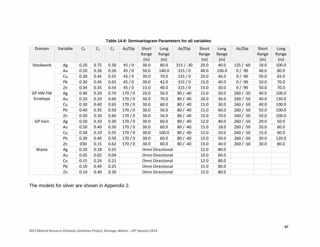
67
2013 Mineral Resource Estimate, Gavilanes Project, Durango, Mexico – 20th January 2014
Table 14-8: Semivariogram Parameters for all variables
Domain Variable C0 C1 C2 Az/Dip Short Range
(m)
Long Range
(m)
Az/Dip Short Range
(m)
Long Range
(m)
Az/Dip Short Range
(m)
Long Range
(m)
Stockwork Ag 0.20 0.75 0.30 45 / 0 30.0 60.0 315 / -30 20.0 40.0 135 / -60 18.0 100.0
Au 0.20 0.26 0.26 45 / 0 50.0 140.0 315 / 0 40.0 100.0 0 / -90 40.0 80.0
Cu 0.30 0.45 0.55 45 / 0 30.0 70.0 315 / 0 20.0 46.0 0 / -90 50.0 65.0
Pb 0.30 0.45 0.65 45 / 0 30.0 42.0 315 / 0 15.0 40.0 0 / -90 50.0 70.0
Zn 0.34 0.35 0.54 45 / 0 15.0 40.0 315 / 0 15.0 30.0 0 / -90 50.0 70.0
GP HW-FW Envelope
Ag 0.40 0.20 0.70 170 / 0 20.0 56.0 80 / -40 15.0 50.0 260 / -50 40.0 100.0
Au 0.20 0.20 0.60 170 / 0 30.0 70.0 80 / -40 20.0 36.0 260 / -50 40.0 130.0
Cu 0.30 0.40 0.65 170 / 0 30.0 60.0 80 / -40 15.0 30.0 260 / -50 40.0 100.0
Pb 0.40 0.35 0.50 170 / 0 30.0 56.0 80 / -40 15.0 60.0 260 / -50 50.0 100.0
Zn 0.30 0.30 0.60 170 / 0 30.0 56.0 80 / -40 15.0 70.0 260 / -50 50.0 100.0
GP Vein Ag 0.50 0.10 0.30 170 / 0 30.0 60.0 80 / -40 12.0 40.0 260 / -50 20.0 50.0
Au 0.50 0.40 0.50 170 / 0 30.0 60.0 80 / -40 15.0 18.0 260 / -50 20.0 60.0
Cu 0.58 0.10 0.55 170 / 0 30.0 100.0 80 / -40 15.0 20.0 260 / -50 15.0 60.0
Pb 0.30 0.40 0.50 170 / 0 30.0 60.0 80 / -40 15.0 50.0 260 / -50 30.0 120.0
Zn 030 0.15 0.62 170 / 0 30.0 60.0 80 / -40 15.0 40.0 260 / -50 30.0 80.0
Waste Ag 0.20 0.18 0.25 Omni Directional 12.0 80.0
Au 0.05 0.02 0.04 Omni Directional 10.0 60.0
Cu 0.15 0.24 0.21 Omni Directional 12.0 80.0
Pb 0.10 0.40 0.25 Omni Directional 15.0 80.0
Zn 0.10 0.40 0.30 Omni Directional 15.0 80.0
The models for silver are shown in Appendix 2.

68
2013 Mineral Resource Estimate, Gavilanes Project, Durango, Mexico – 20th January 2014
14.4 Block Model
A block model with blocks 5 x 2.5 x 5 m in dimension was superimposed over the mineralized solids and for each block the percentage below surface topography and the percentage within each of the mineralized solids were recorded. The block model origin is shown below.
Lower Left corner:
425445 East Column size = 2.5 m 176 Columns
2678100 North Row size = 5 m 158 Rows
Top of Model:
2310 Elevation Level size = 5 m 113 Levels
No Rotation
Figure 14-5 Isometric view looking N showing stockwork in orange, GP vein in magenta surrounded by GP Envelope in Red, DS vein in blue surrounded by DS envelope in green and
SN structure in yellow

69
2013 Mineral Resource Estimate, Gavilanes Project, Durango, Mexico – 20th January 2014
14.5 Bulk Density
A total of 216 specific gravity determinations were completed on pieces of drill core using the Archimedes (weight in air – weight in water) methodology. The results are shown in Appendix 3 and can be subdivided by domain type.
Table 14-9: Specific Gravity Determination sorted by Domain
Domain Number Of Samples
Minimum SG
Maximum SG
Average SG
DS 3 2.32 2.58 2.44
GP 23 2.05 3.87 2.62
SN 5 2.23 2.53 2.40
Vein DS 2 2.55 2.58 2.56
Vein GP 11 2.35 2.74 2.60
Stockwork 43 1.90 3.07 2.58
Waste 129 1.93 2.79 2.44
Total 216 1.90 3.87 2.49
For this resource estimation the average specific gravity for each domain was used to convert volume to tonnes. In future drill campaigns more measurements should be taken and compared to the grades of the samples to establish if a relationship between grade and density exists. If so a regression equation could be established and used to estimate a density for each block based on the block grade.
14.6 Grade Interpolation
Interpolation of grades into the block model was completed by Ordinary Kriging in a series of passes. In all cases the search ellipse dimensions and orientation were tied to the semivariogram for the domain and variable being estimated. The first pass used search ellipse dimensions equal to ¼ of the semivariogram range. A minimum of four and a maximum of twelve composites were required with a maximum of 3 from any given drill hole allowed. For blocks not estimated in pass 1 a second pass using ½ the semivariogram range was used. A third pass using the full range and a fourth pass using twice the range completed the exercise.
Using this strategy blocks with some percentage of stockwork mineralization present were estimated first, using only stockwork composites. Blocks containing some percentage of GP vein were then estimated using the smaller GP vein composites. Next the blocks with some percentage of GP envelope present were estimated using only GP envelope composites. For blocks estimated with GP envelope grades and containing un-estimated percentages of GP vein, the grades for the GP envelope were assigned to the vein material. Next the DS vein and envelope were estimated in a similar manner. Finally the SN material was estimated from SN composites.
For every block with some percentage of waste or material outside the mineralized solids present, grades were interpolated from composites outside the mineralized solids.
The mineralized portion of blocks was a weighted average of each of the domains present, as is shown below for silver as an example.

70
2013 Mineral Resource Estimate, Gavilanes Project, Durango, Mexico – 20th January 2014
𝐴𝑔 𝑀𝑖𝑛 =(%𝑆𝑇𝑋×𝐴𝑔𝑆𝑇𝑋)+(% 𝐺𝑃×𝐴𝑔𝐺𝑃)+(%𝐺𝑃𝑉𝑒𝑖𝑛×𝐴𝑔𝐺𝑃𝑉)+(%𝐷𝑆×𝐴𝑔𝐷𝑆)+(%𝐷𝑆𝑉𝑒𝑖𝑛×𝐴𝑔𝐷𝑆𝑉)+(%𝑆𝑁×𝐴𝑔𝑆𝑁)
% 𝑀𝑖𝑛
The total block grade was then a weighted average of the mineralized and waste portions of the block.
𝐴𝑔 𝑇𝑜𝑡 =(%𝑀𝑖𝑛 × 𝐴𝑔𝑀𝑖𝑛) + (%𝑊𝑎𝑠𝑡𝑒 × 𝐴𝑔𝑊𝑎𝑠𝑡𝑒)
%𝐵𝑒𝑙𝑜𝑤𝑇𝑜𝑝𝑜
The kriging parameters are shown along with the number of blocks estimated for silver in the table below. Also listed, are the number of blocks within the various solids not estimated.
Table 14-10: Kriging Parameters for Silver
Domain Pass Number Estimated
Az/Dip Dist. (m)
Az/Dip Dist. (m)
Az/Dip Dist. (m)
Stockwork (1,507 not estimated)
1 1,144 45/0 15.0 315/-30 10.0 135/-60 25.0
2 16,834 45/0 30.0 315/-30 20.0 135/-60 50.0
3 80,092 45/0 60.0 315/-30 40.0 135/-60 100.0
4 39,207 45/0 120.0 315/-30 80.0 135/-60 200.0
GP Vein (8,966 not estimated)
1 10 170/0 15.0 80/-40 10.0 260/-50 12.5
2 1,301 170/0 30.0 80/-40 20.0 260/-50 25.0
3 8,703 170/0 60.0 80/-40 40.0 260/-50 50.0
4 11,615 170/0 120.0 80/-40 80.0 260/-50 100.0
GP Envelope (12,355 not estimated)
1 1,039 170/0 14.0 80/-40 12.5 260/-50 25.0
2 15,335 170/0 28.0 80/-40 25.0 260/-50 50.0
3 44,506 170/0 56.0 80/-40 50.0 260/-50 100.0
4 57,889 170/0 112.0 80/-40 100.0 260/-50 200.0
DS Vein (511 not
estimated)
1 15 170/0 15.0 80/-25 10.0 260/-65 12.5
2 863 170/0 30.0 80/-25 20.0 260/-65 25.0
3 1,847 170/0 60.0 80/-25 40.0 260/-65 50.0
4 2,186 170/0 120.0 80/-25 80.0 260/-65 100.0
DS Envelope (689 not
estimated)
1 540 170/0 14.0 80/-25 12.5 260/-65 25.0
2 3,632 170/0 28.0 80/-25 25.0 260/-65 50.0
3 5,714 170/0 56.0 80/-25 50.0 260/-65 100.0
4 6,348 170/0 112.0 80/-25 100.0 260/-65 200.0
SN Envelope (196 not
estimated)
1 51 310/0 14.0 220/-10 12.5 40/-80 25.0
2 1,133 310/0 28.0 220/-10 25.0 40/-80 50.0
3 3,882 310/0 56.0 220/-10 50.0 40/-80 100.0
4 3,161 310/0 112.0 220/-10 100.0 40/-80 200.0
Waste 1 1,047 Omni Directional 20.0
2 13,891 Omni Directional 40.0
3 36,781 Omni Directional 80.0
4 30,981 Omni Directional 160.0

71
2013 Mineral Resource Estimate, Gavilanes Project, Durango, Mexico – 20th January 2014
14.7 Classification
Based on the study herein reported, delineated mineralization of the Gavilanes Deposit is classified as a resource according to the following definitions from NI 43-101 and from CIM (2005):
“In this Instrument, the terms "mineral resource", "inferred mineral resource", "indicated mineral resource" and "measured mineral resource" have the meanings ascribed to those terms by the Canadian Institute of Mining, Metallurgy and Petroleum, as the CIM Definition Standards on Mineral Resources and Mineral Reserves adopted by CIM Council, as those definitions may be amended.”
“A Mineral Resource is a concentration or occurrence of diamonds, natural solid inorganic material, or natural solid fossilized organic material including base and precious metals, coal and industrial minerals in or on the Earth’s crust in such form and quantity and of such a grade or quality that it has reasonable prospects for economic extraction. The location, quantity, grade, geological characteristics and continuity of a Mineral Resource are known, estimated or interpreted from specific geological evidence and knowledge.”
“The term Mineral Resource covers mineralization and natural material of intrinsic economic interest which has been identified and estimated through exploration and sampling and within which Mineral Reserves may subsequently be defined by the consideration and application of technical, economic, legal, environmental, socio-economic and governmental factors. The phrase ‘reasonable prospects for economic extraction’ implies a judgment by the Qualified Person in respect of the technical and economic factors likely to influence the prospect of economic extraction. A Mineral Resource is an inventory of mineralization that under realistically assumed and justifiable technical and economic conditions might become economically extractable. These assumptions must be presented explicitly in both public and technical reports.”
The terms Measured, Indicated and Inferred are defined by CIM (2005) as follows:
“A 'Measured Mineral Resource' is that part of a Mineral Resource for which quantity, grade or quality, densities, shape, physical characteristics are so well established that they can be estimated with confidence sufficient to allow the appropriate application of technical and economic parameters, to support production planning and evaluation of the economic viability of the deposit. The estimate is based on detailed and reliable exploration, sampling and testing information gathered through appropriate techniques from locations such as outcrops, trenches, pits, workings and drill holes that are spaced closely enough to confirm both geological and grade continuity.”
“An 'Indicated Mineral Resource' is that part of a Mineral Resource for which quantity, grade or quality, densities, shape and physical characteristics can be estimated with a level of confidence sufficient to allow the appropriate application of technical and economic parameters, to support mine planning and evaluation of the economic viability of the deposit. The estimate is based on detailed and reliable exploration and testing information gathered through appropriate techniques from locations such as outcrops, trenches, pits, workings and drill holes that are spaced closely enough for geological and grade continuity to be reasonably assumed.”

72
2013 Mineral Resource Estimate, Gavilanes Project, Durango, Mexico – 20th January 2014
“An 'Inferred Mineral Resource' is that part of a Mineral Resource for which quantity and grade or quality can be estimated on the basis of geological evidence and limited sampling and reasonably assumed, but not verified, geological and grade continuity. The estimate is based on limited information and sampling gathered through appropriate techniques from locations such as outcrops, trenches, pits, workings and drill holes.”
Geologic continuity has been established from surface and underground mapping and drill hole interpretation. This has led to the geologic solid model which constrains the estimate. The grade continuity has been established from the semivariogram analysis. The semivariogram orientations and ranges have been used to align and dimension the search ellipsoids, used in the grade interpolation.
Blocks estimated in Pass 1 and 2 using up to ½ the semivariogram range are classified as Indicated in the domains where variography was possible, namely stockwork, GP envelope and GP vein. The distribution of these blocks is shown as Figure 14.6.
Figure 14-6 Isometric view looking NW showing Indicated blocks in green, vein composites in magenta and other composites in red
All other estimated blocks are classified as Inferred at this time.
There are no underground solids at this time to delineate the underground workings on the Guadalupe structure. As a result all estimated blocks above the 2125 m level

73
2013 Mineral Resource Estimate, Gavilanes Project, Durango, Mexico – 20th January 2014
on this structure were removed from the estimate. A total of 25,687 blocks were removed.
The resource can be stated in a number of ways. In the first set of tables (14-11 & 14-12) the portion of the resource contained within the 6 mineralized solids is reported. This resource assumes one could mine to the limits of the solid boundaries and no edge dilution is reported. The next set of tables (14-13 & 14-14) report the tonnage contained in total blocks (2.5 x 5 x 5 m). This resource assumes one would mine these total blocks and includes all mineralized material plus external waste contained in a block. In reality the resource that one might mine is somewhere between these two extremes as one could never mine with zero dilution but to dilute to a total 2.5 x 5 x 5 m block is probably excessive. The estimation of the waste portion of blocks will be useful when an underground mine plan is developed as the grades for the edge dilution have been estimated on a block by block basis.
At this time no economic studies have been completed and an economic cut-off value is unknown. In the following tables the mineral content at a cut-off of 75 g/t Aq equivalent have been highlighted as the authors are of the opinion that based on the mineralization characteristics, grade, location and other factors described in this report, there is a reasonable prospect for economic extraction at this grade.
Table 14-11: Resource classed as Indicated within Mineralized Solids
Cut-off Ag (g/t)
Tonnes > Cut-off (tonnes)
Grade > Cut-off
Ag (g/t) Au (g/t) Cu (%) Pb (%) Zn (%)
50.0 997,000 160.8 0.08 0.05 0.37 0.39
55.0 930,000 168.6 0.08 0.05 0.38 0.40
60.0 871,000 176.2 0.08 0.05 0.39 0.41
65.0 811,000 184.6 0.09 0.05 0.39 0.42
70.0 761,000 192.4 0.09 0.05 0.40 0.42
75.0 710,000 200.9 0.08 0.05 0.40 0.43
80.0 671,000 208.1 0.08 0.05 0.41 0.44
85.0 634,000 215.5 0.08 0.05 0.41 0.45
90.0 604,000 221.9 0.08 0.05 0.42 0.45
95.0 577,000 227.8 0.08 0.05 0.42 0.46
100.0 555,000 233.1 0.08 0.05 0.43 0.46

74
2013 Mineral Resource Estimate, Gavilanes Project, Durango, Mexico – 20th January 2014
Table 14-12: Resource classed as Inferred within Mineralized Solids
Cut-off Ag (g/t)
Tonnes > Cut-off (tonnes)
Grade > Cut-off
Ag (g/t) Au (g/t) Cu (%) Pb (%) Zn (%)
50.0 5,340,000 127.8 0.09 0.07 0.36 0.34
55.0 4,811,000 136.1 0.09 0.07 0.37 0.35
60.0 4,427,000 142.9 0.09 0.07 0.38 0.36
65.0 4,119,000 149.0 0.08 0.07 0.39 0.37
70.0 3,864,000 154.3 0.08 0.07 0.39 0.38
75.0 3,649,000 159.2 0.08 0.07 0.40 0.39
80.0 3,456,000 163.7 0.08 0.06 0.40 0.40
85.0 3,285,000 168.0 0.08 0.06 0.41 0.41
90.0 3,126,000 172.1 0.08 0.06 0.41 0.41
95.0 2,960,000 176.5 0.08 0.06 0.42 0.42
100.0 2,796,900 181.2 0.08 0.06 0.42 0.43
Table 14-13: Resource classed as Indicated within Total Blocks
Cut-off Ag (g/t)
Tonnes > Cut-off (tonnes)
Grade > Cut-off
Ag (g/t) Au (g/t) Cu (%) Pb (%) Zn (%) 50.0 1,002,000 159.8 0.08 0.05 0.37 0.39
55.0 935,000 167.6 0.08 0.05 0.38 0.40
60.0 875,000 175.1 0.08 0.05 0.39 0.41
65.0 814,000 183.4 0.09 0.05 0.39 0.42
70.0 762,000 191.4 0.09 0.05 0.40 0.42
75.0 711,000 200.0 0.08 0.05 0.40 0.43
80.0 671,000 207.3 0.08 0.05 0.41 0.44
85.0 632,000 215.0 0.08 0.05 0.41 0.45
90.0 601,000 221.6 0.08 0.05 0.42 0.45
95.0 575,000 227.4 0.08 0.05 0.42 0.46
100.0 551,000 233.0 0.08 0.05 0.43 0.46
Table 14-14: Resource classed as Inferred within Total Blocks
Cut-off Ag (g/t)
Tonnes > Cut-off (tonnes)
Grade > Cut-off
Ag (g/t) Au (g/t) Cu (%) Pb (%) Zn (%) 50.0 5,357,000 125.4 0.08 0.07 0.35 0.33
55.0 4,820,000 133.6 0.08 0.07 0.36 0.35
60.0 4,424,000 140.4 0.08 0.07 0.37 0.36
65.0 4,106,000 146.4 0.08 0.07 0.38 0.37
70.0 3,834,000 152.0 0.08 0.07 0.39 0.38
75.0 3,602,000 157.2 0.08 0.06 0.40 0.39
80.0 3,394,000 162.0 0.08 0.06 0.40 0.40
85.0 3,212,000 166.5 0.08 0.06 0.41 0.41
90.0 3,043,000 170.9 0.08 0.06 0.41 0.41
95.0 2,874,000 175.6 0.08 0.06 0.42 0.42
100.0 2,709,400 180.3 0.08 0.06 0.42 0.43

75
2013 Mineral Resource Estimate, Gavilanes Project, Durango, Mexico – 20th January 2014
This deposit has multiple variables and silver is not well correlated with any of them. As a result there are blocks with high grades for gold and copper that might be below an economic cut-off for silver alone. Using a silver equivalent value cut-off would be a better way of presenting the resource. At this time there has been no metallurgical work completed to establish metal recoveries. For the purpose of developing a silver equivalent 100% recovery of all metal is assumed. The reader is cautioned that 100% recovery is never achieved. The metal prices used in the silver equivalent estimate are from a 100 day moving average and are listed below.
Factor
Ag - US$ 21.55 per ounce 0.69 $/gm
Au - US$ 1318.00 per ounce 42.37 $/gm
Cu - US$ 3.25 per pound 71.65 $/%
Pb - US$ 0.97 per pound 21.38 $/%
Zn - US$ 0.87 per pound 19.18 $/%
The equation to establish Ag Equivalent is then:
𝐴𝑔𝐸𝑞 =(𝐶𝑢% × 71.65) + (𝑃𝑏% × 21.38) + (𝐴𝑢𝑝𝑝𝑚 × 42.37) + (𝐴𝑔𝑝𝑝𝑚 × 0.69) + (𝑍𝑛% × 19.18)
0.69
The four tables can then be recast with a Silver Equivalent cut-off.
Table 14-15 AgEq Resource classed as Indicated within Mineralized Solids
Cut-off Tonnes > Cut-off
Grade > Cut-off AgEq
AgEq (g/t) (tonnes) Ag (g/t) Au (g/t) Cu (%) Pb (%) Zn (%) AgEQ (g/t) Ozs.
50.0 1,294,000 132.4 0.08 0.05 0.38 0.36 163.7 6,812,081
55.0 1,196,000 140.4 0.08 0.05 0.39 0.37 172.9 6,646,858
60.0 1,125,000 146.8 0.08 0.05 0.40 0.38 180.2 6,517,032
65.0 1,062,000 152.9 0.09 0.05 0.41 0.39 187.1 6,388,696
70.0 1,003,000 159.0 0.09 0.05 0.42 0.40 194.1 6,259,499
75.0 953,000 164.6 0.09 0.06 0.42 0.41 200.5 6,144,167
80.0 903,000 170.6 0.09 0.06 0.43 0.42 207.4 6,020,968
85.0 860,000 176.2 0.10 0.06 0.44 0.43 213.6 5,906,789
90.0 817,000 182.0 0.10 0.06 0.44 0.44 220.2 5,785,075
95.0 778,000 187.8 0.10 0.06 0.45 0.45 226.7 5,669,506
100.0 735,000 194.6 0.10 0.06 0.46 0.46 234.2 5,534,329
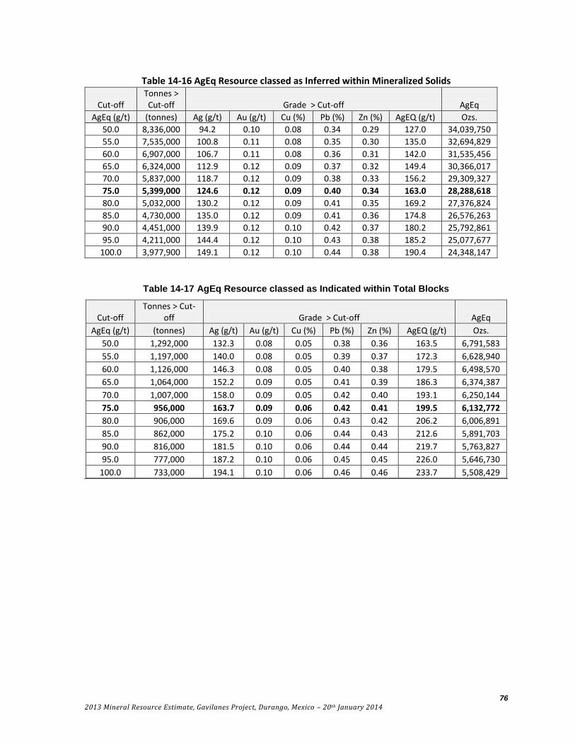
76
2013 Mineral Resource Estimate, Gavilanes Project, Durango, Mexico – 20th January 2014
Table 14-16 AgEq Resource classed as Inferred within Mineralized Solids
Cut-off Tonnes > Cut-off Grade > Cut-off AgEq
AgEq (g/t) (tonnes) Ag (g/t) Au (g/t) Cu (%) Pb (%) Zn (%) AgEQ (g/t) Ozs.
50.0 8,336,000 94.2 0.10 0.08 0.34 0.29 127.0 34,039,750
55.0 7,535,000 100.8 0.11 0.08 0.35 0.30 135.0 32,694,829
60.0 6,907,000 106.7 0.11 0.08 0.36 0.31 142.0 31,535,456
65.0 6,324,000 112.9 0.12 0.09 0.37 0.32 149.4 30,366,017
70.0 5,837,000 118.7 0.12 0.09 0.38 0.33 156.2 29,309,327
75.0 5,399,000 124.6 0.12 0.09 0.40 0.34 163.0 28,288,618
80.0 5,032,000 130.2 0.12 0.09 0.41 0.35 169.2 27,376,824
85.0 4,730,000 135.0 0.12 0.09 0.41 0.36 174.8 26,576,263
90.0 4,451,000 139.9 0.12 0.10 0.42 0.37 180.2 25,792,861
95.0 4,211,000 144.4 0.12 0.10 0.43 0.38 185.2 25,077,677
100.0 3,977,900 149.1 0.12 0.10 0.44 0.38 190.4 24,348,147
Table 14-17 AgEq Resource classed as Indicated within Total Blocks
Cut-off Tonnes > Cut-
off Grade > Cut-off AgEq
AgEq (g/t) (tonnes) Ag (g/t) Au (g/t) Cu (%) Pb (%) Zn (%) AgEQ (g/t) Ozs.
50.0 1,292,000 132.3 0.08 0.05 0.38 0.36 163.5 6,791,583
55.0 1,197,000 140.0 0.08 0.05 0.39 0.37 172.3 6,628,940
60.0 1,126,000 146.3 0.08 0.05 0.40 0.38 179.5 6,498,570
65.0 1,064,000 152.2 0.09 0.05 0.41 0.39 186.3 6,374,387
70.0 1,007,000 158.0 0.09 0.05 0.42 0.40 193.1 6,250,144
75.0 956,000 163.7 0.09 0.06 0.42 0.41 199.5 6,132,772
80.0 906,000 169.6 0.09 0.06 0.43 0.42 206.2 6,006,891
85.0 862,000 175.2 0.10 0.06 0.44 0.43 212.6 5,891,703
90.0 816,000 181.5 0.10 0.06 0.44 0.44 219.7 5,763,827
95.0 777,000 187.2 0.10 0.06 0.45 0.45 226.0 5,646,730
100.0 733,000 194.1 0.10 0.06 0.46 0.46 233.7 5,508,429

77
2013 Mineral Resource Estimate, Gavilanes Project, Durango, Mexico – 20th January 2014
Table 14-18 AgEq Resource classed as Inferred within Total Blocks
Cut-off Tonnes > Cut-off Grade > Cut-off AgEq
AgEq (g/t) (tonnes) Ag (g/t) Au (g/t) Cu (%) Pb (%) Zn (%) AgEQ (g/t) Ozs.
50.0 8,306,000 93.2 0.10 0.08 0.33 0.29 125.5 33,500,657
55.0 7,508,000 99.7 0.11 0.08 0.34 0.30 133.2 32,157,659
60.0 6,877,000 105.5 0.11 0.08 0.35 0.31 140.2 30,993,871
65.0 6,293,000 111.5 0.11 0.09 0.37 0.32 147.4 29,822,631
70.0 5,797,000 117.3 0.11 0.09 0.38 0.33 154.3 28,748,766
75.0 5,354,000 123.1 0.12 0.09 0.39 0.34 161.0 27,715,451
80.0 4,994,000 128.4 0.12 0.09 0.40 0.35 167.0 26,820,061
85.0 4,678,000 133.4 0.12 0.09 0.41 0.36 172.8 25,981,787
90.0 4,391,000 138.3 0.12 0.09 0.42 0.37 178.3 25,176,940
95.0 4,137,000 143.0 0.12 0.09 0.43 0.37 183.6 24,421,514
100.0 3,896,700 147.7 0.12 0.09 0.44 0.39 188.9 23,668,223
As would be expected using a silver equivalent cut-off the grades for silver above any given cut-off have decreased while the Au and Cu values have increased and the tonnage has increased significantly.
Table 14-19 shows where the material reported at a 75 g/t Ag cut-off within the mineralized portion of blocks comes from. Of note is that no blocks within the DS Envelope are above a 75 g/t Ag cut-off.
Table 14-19 Mineralized Portion of Blocks above a 75 g/t Ag Cut-off
Classification Domain Cut-off
Ag (g/t)
Percentage Total
tonnage
Grade > Cut-off
Ag (g/t)
Au (g/t)
Cu (%) Pb (%) Zn (%)
Indicated
GP Envelope
75.0 47.6% 200.7 0.08 0.07 0.43 0.38
GP Vein 75.0 11.0% 213.0 0.27 0.10 1.40 1.80
Stockwork 75.0 41.4% 212.7 0.05 0.02 0.15 0.18
Inferred
GP Envelope
75.0 29.0% 151.6 0.11 0.13 0.38 0.26
GP Vein 75.0 18.0% 205.3 0.23 0.12 1.19 1.36
DS Vein 75.0 8.2% 347.2 0.04 0.04 0.65 0.67
SN Structure
75.0 8.9% 145.1 0.02 0.04 0.30 0.28
Stockwork 75.0 35.8% 146.4 0.05 0.03 0.10 0.11
78
2013 Mineral Resource Estimate, Gavilanes Project, Durango, Mexico – 20th January 2014
15 ADJACENT PROPERTIES
There are no mineral properties with significant work directly adjacent to Gavilanes. The closest significant project is the San Dimas Mine (Tayoltita) operated by Primero Mining Corp (TSX:P) which produced 111,162 ounces of gold equivalent in 2012 (Primero 2012 annual report). Historic production at Tayoltita is estimated at 654 Moz Ag and 9.14 Moz Au from 10 Mt of ore (Enriquez & Rivera, 2001). Tayoltita is approximately 25 km to the west of Gavilanes. The authors have not verified any information regarding Tayoltita. The production information stated above is not indicative of mineralization at the Gavilanes Project.
16 OTHER RELEVANT DATA AND INFORMATION
The authors are not aware of any other data relevant to this report or resource estimation.
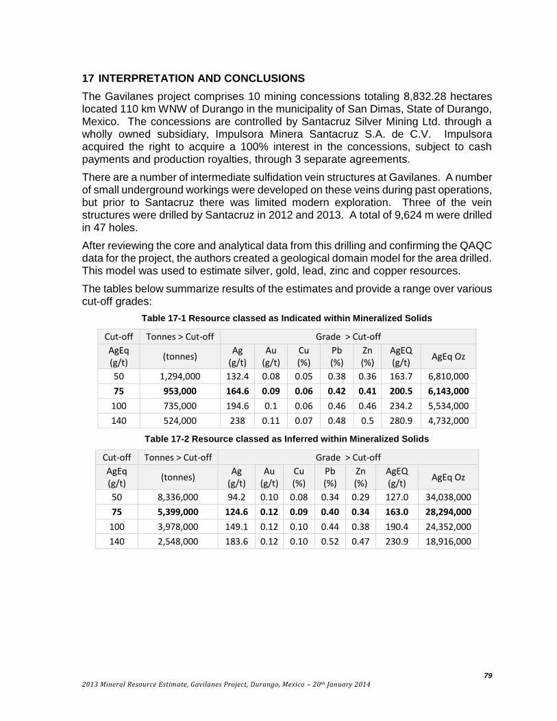
79
2013 Mineral Resource Estimate, Gavilanes Project, Durango, Mexico – 20th January 2014
17 INTERPRETATION AND CONCLUSIONS
The Gavilanes project comprises 10 mining concessions totaling 8,832.28 hectares located 110 km WNW of Durango in the municipality of San Dimas, State of Durango, Mexico. The concessions are controlled by Santacruz Silver Mining Ltd. through a wholly owned subsidiary, Impulsora Minera Santacruz S.A. de C.V. Impulsora acquired the right to acquire a 100% interest in the concessions, subject to cash payments and production royalties, through 3 separate agreements.
There are a number of intermediate sulfidation vein structures at Gavilanes. A number of small underground workings were developed on these veins during past operations, but prior to Santacruz there was limited modern exploration. Three of the vein structures were drilled by Santacruz in 2012 and 2013. A total of 9,624 m were drilled in 47 holes.
After reviewing the core and analytical data from this drilling and confirming the QAQC data for the project, the authors created a geological domain model for the area drilled. This model was used to estimate silver, gold, lead, zinc and copper resources.
The tables below summarize results of the estimates and provide a range over various cut-off grades:
Table 17-1 Resource classed as Indicated within Mineralized Solids
Cut-off Tonnes > Cut-off Grade > Cut-off
AgEq (g/t)
(tonnes) Ag
(g/t) Au
(g/t) Cu (%)
Pb (%)
Zn (%)
AgEQ (g/t)
AgEq Oz
50 1,294,000 132.4 0.08 0.05 0.38 0.36 163.7 6,810,000
75 953,000 164.6 0.09 0.06 0.42 0.41 200.5 6,143,000
100 735,000 194.6 0.1 0.06 0.46 0.46 234.2 5,534,000
140 524,000 238 0.11 0.07 0.48 0.5 280.9 4,732,000
Table 17-2 Resource classed as Inferred within Mineralized Solids
Cut-off Tonnes > Cut-off Grade > Cut-off
AgEq (g/t)
(tonnes) Ag
(g/t) Au
(g/t) Cu (%)
Pb (%)
Zn (%)
AgEQ (g/t)
AgEq Oz
50 8,336,000 94.2 0.10 0.08 0.34 0.29 127.0 34,038,000
75 5,399,000 124.6 0.12 0.09 0.40 0.34 163.0 28,294,000
100 3,978,000 149.1 0.12 0.10 0.44 0.38 190.4 24,352,000
140 2,548,000 183.6 0.12 0.10 0.52 0.47 230.9 18,916,000

80
2013 Mineral Resource Estimate, Gavilanes Project, Durango, Mexico – 20th January 2014
The metal prices used in the silver equivalent estimate are listed below.
Factor
Ag - US$ 21.55 per ounce 0.69 $/gm
Au - US$ 1318.00 per ounce 42.37 $/gm
Cu - US$ 3.25 per pound 71.65 $/%
Pb - US$ 0.97 per pound 21.38 $/%
Zn - US$ 0.87 per pound 19.18 $/%
The equation to establish Ag Equivalent is then:
𝐴𝑔𝐸𝑞 =(𝐶𝑢% × 71.65) + (𝑃𝑏% × 21.38) + (𝐴𝑢𝑝𝑝𝑚 × 42.37) + (𝐴𝑔𝑝𝑝𝑚 × 0.69) + (𝑍𝑛% × 19.18)
0.69
100% recovery has been assumed for all metals in this silver equivalent estimate. At this stage of the project no metallurgy has been completed and the reader is cautioned that 100% recoveries are never achieved.
Highlights of the mineral resource estimate are as follows:
Indicated mineral resources of 6,143,000 AgEq ounces grading 200 g/t AgEq
Inferred mineral resource of 28,294,000 AgEq ounces grading 163 g/t AgEq;
Veins remain open along strike and to depth with intermittent surface exposures indicating an untested strike length;
The stockwork zone is open down-dip and to the south.
The identified indicated and inferred resource is significant, however engineering and economic studies have not been completed and thus no statement can be made about the project’s potential economic viability.
The full limits of the veins that host the resource have not yet been delineated and potential exists to increase the resource by expansion along strike and to depth. There are a number of other vein structures on the property which provide further potential.
The results achieved to date at Gavilanes warrant continued exploration including drilling to upgrade and potentially expand resources. A program of metallurgy and basic engineering to assess the project’s economic viability is also warranted.
There are no obvious environmental, permitting, legal, title, taxation, socio-economic, marketing, political or other relevant factors which would materially affect this resource. Further exploration of the Gavilanes Project is subject to normal exploration risks including the ability of the Company to raise funding, potential decreases in metal prices and unforeseen changes in Mexican mining and environmental laws and regulations.

81
2013 Mineral Resource Estimate, Gavilanes Project, Durango, Mexico – 20th January 2014
18 RECOMMENDATIONS
Recommended work at Gavilanes includes drilling in the area of current resources with the intent of upgrading resources to Indicated and Measured, drilling the open extent of the area with resources, testing other targets on the property and undertaking preliminary metallurgy, engineering and environmental studies.
The recommended work plan is a one year program and includes:
Prepare an orthophoto and detailed topographic model for the property.
Map the property at 1:10,000 or smaller scale as appropriate.
Continue the surface sampling program.
Drill to upgrade resources – approximately 8,000 metres of HQ core in 50 holes.
Drill to potentially expand resources - approximately 6,000 metres in 30 holes.
Drill other veins to test potential – approximately 4,000 metres in 30 holes.
Conduct preliminary metallurgy studies on the current Domains – 6 composites.
Start a baseline sampling program on the creeks.
Sample and analyze core intervals within the resource Domains that were not sampled.
Secure old workings to prevent people and animals from entering.
Survey old workings.
Sample wallrock exposures in the Guadalupe vein workings in areas where drill holes indicate potential for mineralization.
Continue to take density measurements with the intent of developing a density versus grade model.
Obtain additional silver standards so as to have a low, medium and high grade standard.
Use a silver blank instead of a gold blank. A coarse blank can be developed using unmineralized rock from the area.
Collect preparation and assay duplicates of drill program samples.
Routinely send select drill sample assay pulps to a second laboratory for check assaying.
The total cost of the recommended work plan is $3.7M USD as shown in Table 18-1.

82
2013 Mineral Resource Estimate, Gavilanes Project, Durango, Mexico – 20th January 2014
Table 18-1 Recommended work program budget (one year)
Item Unit Amount Item Cost Cost Comments
Orthophoto and Topo
hectares 4,000 10 40,000
Drilling - contractor metres 18,000 120 2,160,000
Drilling - assays and support 18,000 70 1,260,000
Mapping days 100 500 50,000 including personnel and camp
Sampling samples 500 100 50,000 including assaying, personnel and camp
Metallurgy composites 5 2,500 12,500
Environmental Sampling
Times 4 5,000 20,000 Sample every 3 months
Other Work 100,000
Total 3,692,500 $US
83
2013 Mineral Resource Estimate, Gavilanes Project, Durango, Mexico – 20th January 2014
19 REFERENCES
Bentzen, A., and Sinclair, A.J., 1993, P-RES – a computer program to aid in the investigation of polymetallic ore reserves, Tech. Rept. MT-9 Mineral Deposit Research Unit, Dept. of Geological Sciences U.B.C. 55 pp.
Clarke, M., and Titley, S., 1988, Hydrothermal evolution in the formation of silver-gold veins in the Tayolita Mine, San Dimas district, Mexico: Economic Geology, v.83, p. 1830-1840.
Conrad, M., Petersen, U., and O’Neil, J., 1992, Evolution of an Au-Ag-producing hydrothermal system: the Tayoltita Mine, Durango, Mexico: Economic Geology, v.87, p.1451-1474.
Enriquez, E., and Rivera, R., 2001, Geology of the Santa Rita Ag-Au deposit, San Dimas district, Durango, Mexico: Society of Economic Geology, SP8, p.39-58.
Ferrari, L., Moreno, M., and Bryan, S., 2007, Magmatism and tectonics of the Sierra Madre Occidental and its relation with the evolution of the western margin of North America: Geologic Society of America Special Paper 22, p.1-39.
Gemmell, J., Simmons, S., and Zantop, H., 1988, The Santo Nino silver-lead-zinc vein, Fresnillo District, Zacatecas, Mexico: Part I. structure, vein stratigraphy, and mineralology: Economic Geology, v.83, p. 1597-1618.
Hedinquist, J., Arribas, A., and Gonzalez-Urien, E., 2000, Exploration for epithermal gold deposits: Society of Economic Geology, v.13, p. 245-277.
Henley, R., 1985, The geothermal framework of epithermal deposits: Reviews in Economic Geology, v. 2, p. 1-24.
McCammon R. B. and Wenninger G. 1970, The Dendrograph, Computer Contribution 48, State Geological Survey, The University of Kansas, Lawrence, Kansas; in cooperation with the American Association of Petroleum Geologists.
Newton, M.C., and Hulse, D.E., 2011, NI 43-101 technical report on the Gavilanes project, geology, mineralization and historical exploration results Gavilanes, Mexico. SEDAR.
Rowland, J., and Simmons, S., 2012, Hydrologic, magmatic, and tectonic controls on hydrothermal flow, Taupo Volcanic Zone, New Zealand: Implications for formation of epithermal vein deposits: Economic Geology, v.107, p.427-457.
Sillitoe, R., Hedinquist, J., 2003, Linkages between volcanotectonic settings, ore-fluid compositions, and epithermal precious metal deposits: Society of Economic Geology Special Publication 10, p. 315-343.
Simmons, S., Gemmell, J., and Sawkins, F., 1988, The Santo Nino silver-lead-zinc vein, Fresnillo District, Zacatecas, Mexico: Part II. Physical and chemical nature of ore-forming solutions: Economic Geology, v.83, p. 1619-1641.
Simmons, S., White, N., and John, D., 2005, Geologic characteristics of epithermal precious and base metal deposits: Society of Economic Geology, v. 100, p. 485-522.

84
2013 Mineral Resource Estimate, Gavilanes Project, Durango, Mexico – 20th January 2014
Sinclair, A.J., 1974, Applications of probability graphs in mineral exploration, Spec. v. Association of Exploration Geochemists, 95 pages.
Spring, V., and Watts, G., 2011, Technical report on the Tayoltita, Santa Rita and San Antonio mines, Durango, Mexico for Silver Wheaton Corp. SEDAR.

85
2013 Mineral Resource Estimate, Gavilanes Project, Durango, Mexico – 20th January 2014
APPENDIX 1 – LISTING OF DRILL HOLES USED IN THE RESOURCE ESTIMATE Hole_ID N_NAD27 E_NAD27 Elevation Depth Az Dip SCGP-01 2678450.71 425662.54 2139.70 141.15 69.90 -45.10
SCGP-02 2678450.53 425661.86 2139.65 159.95 74.00 -60.90
SCGP-03 2678420.40 425507.91 2135.62 223.70 93.20 -46.50
SCGP-04 2678420.40 425506.91 2135.91 267.10 95.60 -70.70
SCGP-05 2678483.33 425558.34 2144.61 185.55 78.60 -45.80
SCGP-06 2678359.84 425620.47 2147.80 195.95 93.20 -45.10
SCGP-07 2678359.70 425621.57 2147.91 231.00 93.00 -60.10
SCGP-08 2678483.18 425556.85 2144.63 232.30 75.80 -75.10
SCGP-09 2678485.60 425600.86 2146.29 239.10 97.70 -59.20
SCGP-10 2678420.18 425505.85 2135.61 329.90 103.70 -85.80
SCGP-11 2678508.00 425661.00 2141.00 163.25 75.40 -76.20
SCGP-12 2678568.93 425681.60 2144.89 138.95 75.30 -44.90
SCGP-13 2678568.65 425680.56 2145.04 202.95 78.10 -74.50
SCGP-14 2678613.16 425637.95 2149.35 147.50 77.00 -45.80
SCGP-15 2678613.03 425636.83 2149.45 230.40 72.70 -69.80
SCGP-16 2678612.83 425636.20 2149.55 161.95 359.10 -89.90
SCGP-17 2678587.55 425639.82 2146.90 148.05 90.00 -74.90
SCGP-18 2678587.60 425639.33 2146.91 181.90 47.30 -89.60
SCGP-19 2678711.42 425613.09 2166.03 121.95 77.00 -36.90
SCGP-20 2678711.11 425611.20 2166.01 140.40 78.50 -61.30
SCGP-21 2678450.34 425661.47 2139.71 197.80 73.80 -75.20
SCGP-22 2678364.63 425598.27 2133.89 216.00 92.20 -69.70
SCGP-23 2678711.08 425610.87 2166.07 182.85 80.90 -75.30
SCGP-24 2678711.04 425610.23 2165.36 200.50 0.00 -89.10
SCGP-25 2678508.00 425663.00 2141.00 130.60 78.00 -41.10
SCGP-26 2678408.00 425638.00 2145.00 149.20 73.47 -43.40
SCGP-27 2678408.00 425638.00 2145.00 161.05 76.58 -79.90
SCGP-28 2678287.00 425793.00 2234.00 146.70 56.17 -66.05
SCHN-01 2678344.00 425536.28 2098.63 239.20 85.30 -66.10
SCHN-02 2678343.95 425535.71 2098.64 205.30 84.10 -85.30
SCHN-03 2678330.00 425607.00 2150.00 191.10 86.80 -42.40
SCHN-04 2678305.87 425521.04 2095.77 220.00 86.70 -50.20
SCHN-05 2678305.72 425520.26 2095.77 203.05 83.50 -70.80
SCHN-07 2678305.23 425514.16 2095.70 281.20 148.60 -89.90
SCHN-08 2678307.15 425518.55 2095.74 172.20 135.10 -59.90
SCHN-09 2678307.62 425518.03 2095.78 259.75 134.10 -80.60
SCHN-10 2678300.00 425578.00 2138.00 250.20 89.60 -50.60
SCHN-11 2678330.00 425607.00 2150.00 208.60 89.70 -60.30
SCHN-12 2678330.00 425607.00 2150.00 231.30 89.00 -74.00
SCHN-13 2678300.00 425578.00 2138.00 242.50 83.50 -34.90
SCPV-01 2678828.90 425524.04 2247.98 267.90 88.50 -49.60
SCPV-02 2678828.91 425523.01 2248.43 282.40 89.70 -70.40
SCSN-01 2678290.00 425795.00 2234.00 179.00 234.00 -61.00
SCSN-02 2678245.00 425793.00 2214.00 215.00 236.30 -53.90
SCSN-03 2678237.09 425854.09 2205.33 282.50 240.80 -50.40
SCSN-04 2678211.55 425826.17 2198.24 200.00 232.30 -50.20
SCSN-05 2678175.37 425842.49 2176.36 265.00 236.50 -50.50

86
2013 Mineral Resource Estimate, Gavilanes Project, Durango, Mexico – 20th January 2014
APPENDIX 2 – VARIOGRAPHY FOR SILVER

87
2013 Mineral Resource Estimate, Gavilanes Project, Durango, Mexico – 20th January 2014

88
2013 Mineral Resource Estimate, Gavilanes Project, Durango, Mexico – 20th January 2014

89
2013 Mineral Resource Estimate, Gavilanes Project, Durango, Mexico – 20th January 2014

90
2013 Mineral Resource Estimate, Gavilanes Project, Durango, Mexico – 20th January 2014

91
2013 Mineral Resource Estimate, Gavilanes Project, Durango, Mexico – 20th January 2014

92
2013 Mineral Resource Estimate, Gavilanes Project, Durango, Mexico – 20th January 2014
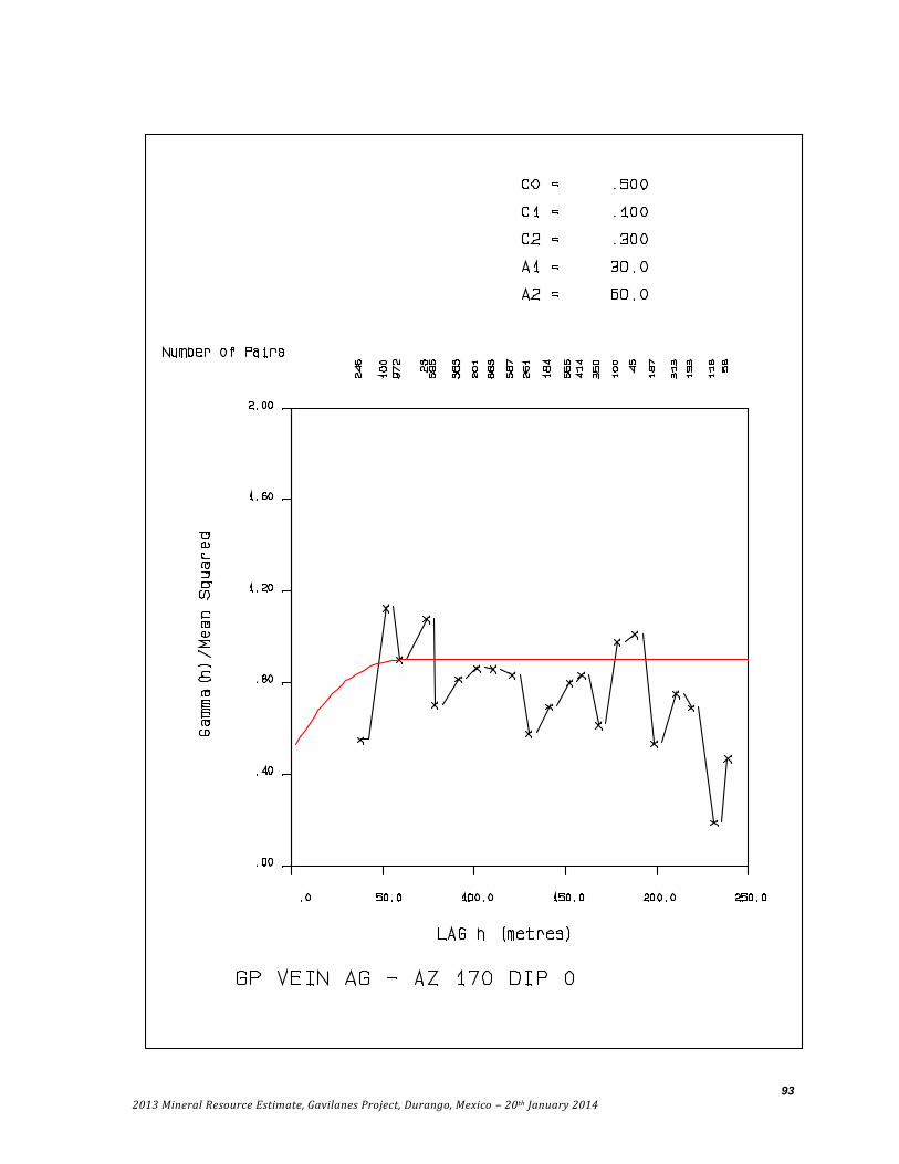
93
2013 Mineral Resource Estimate, Gavilanes Project, Durango, Mexico – 20th January 2014

94
2013 Mineral Resource Estimate, Gavilanes Project, Durango, Mexico – 20th January 2014

95
2013 Mineral Resource Estimate, Gavilanes Project, Durango, Mexico – 20th January 2014

96
2013 Mineral Resource Estimate, Gavilanes Project, Durango, Mexico – 20th January 2014

97
2013 Mineral Resource Estimate, Gavilanes Project, Durango, Mexico – 20th January 2014
APPENDIX 3 – SPECIFIC GRAVITY MEASUREMENTS
Hole_ID Sample Depth(m) SG Density Rock Type Domain
SCGP-01 D1 4.15 2.32 ANDESITA
SCGP-01 D1 10.00 2.63 ANDESITA
SCGP-01 D2 14.40 2.63 BRECHA ANDESITICA
SCGP-01 D2 18.05 2.51 BRECHA ANDESITICA
SCGP-01 D2 23.90 2.41 BRECHA ANDESITICA
SCGP-01 D1 27.00 2.42 ANDESITA
SCGP-01 D1 40.15 2.18 ANDESITA
SCGP-01 D2 77.45 2.51 BRECHA ANDESITICA
SCGP-01 D3 86.45 2.72 VETA CZO V-GP
SCGP-01 D4 100.30 2.60 RIOLITA GP
SCGP-01 D5 115.30 2.48 STOCKWORK ANDESITA GP
SCGP-01 D5 131.65 2.55 STOCKWORK ANDESITA stx
SCGP-01 D5 141.10 2.47 STOCKWORK ANDESITA
SCGP-02 D1 3.75 1.95 ANDESITA
SCGP-02 D1 8.50 2.48 ANDESITA
SCGP-02 D4 19.10 2.38 RIOLITA
SCGP-02 D4 55.80 2.55 RIOLITA
SCGP-02 D1 69.55 2.44 ANDESITA
SCGP-02 D4 89.70 2.40 RIOLITA GP
SCGP-02 D3 95.00 2.70 VETA CZO V-GP
SCGP-02 D1 117.25 2.59 ANDESITA stx
SCGP-02 D1 141.60 2.43 ANDESITA stx
SCGP-02 D1 147.30 2.48 ANDESITA stx
SCGP-02 D1 150.50 2.98 ANDESITA stx
SCGP-02 D1 158.55 2.53 ANDESITA
SCGP-03 D2 10.10 2.31 BRECHA ANDESITICA
SCGP-03 D2 37.55 2.44 BRECHA ANDESITICA
SCGP-03 D1 70.95 2.25 ANDESITA
SCGP-03 D1 93.00 2.51 ANDESITA
SCGP-03 D3 115.30 2.28 VETA CZO stx
SCGP-03 D7 153.35 2.40 STOCKWORK RIOLITA stx
SCGP-03 D1 176.40 2.26 ANDESITA stx
SCGP-03 D4 197.10 2.36 RIOLITA GP
SCGP-03 D3 209.90 3.87 VETA CZO GP
SCGP-03 D1 218.15 2.60 ANDESITA GP
SCGP-05 D1 14.50 2.53 ANDESITA
SCGP-05 D1 32.00 2.62 ANDESITA
SCGP-05 D4 58.25 2.25 RIOLITA

98
2013 Mineral Resource Estimate, Gavilanes Project, Durango, Mexico – 20th January 2014
Hole_ID Sample Depth(m) SG Density Rock Type Domain
SCGP-05 D4 59.90 2.15 RIOLITA
SCGP-05 D1 88.35 2.42 ANDESITA
SCGP-05 D1 99.90 2.33 ANDESITA
SCGP-05 D4 161.10 2.53 RIOLITA
SCGP-06 D1 10.25 2.56 ANDESITA
SCGP-06 D1 50.05 2.54 ANDESITA stx
SCGP-06 D1 95.80 2.71 ANDESITA stx
SCGP-06 D4 116.80 2.67 RIOLITA stx
SCGP-06 D1 123.25 2.59 ANDESITA stx
SCGP-06 D3 129.20 2.35 VETA CZO V-GP
SCGP-06 D1 145.80 2.73 ANDESITA stx
SCGP-06 D1 153.45 2.46 ANDESITA stx
SCGP-06 D3 162.75 2.57 VETA CZO
SCGP-06 D1 174.00 2.61 ANDESITA
SCGP-07 D1 181.60 2.33 ANDESITA stx
SCGP-09 D1 14.25 2.35 ANDESITA
SCGP-09 D4 21.25 2.47 RIOLITA
SCGP-09 D1 32.70 2.47 ANDESITA
SCGP-09 D1 40.90 2.48 ANDESITA
SCGP-09 D1 65.40 2.51 ANDESITA
SCGP-09 D4 114.00 2.75 RIOLITA stx
SCGP-09 D6 150.80 3.18 VETA GP
SCGP-09 D3 155.40 3.17 VETA CZO GP
SCGP-11 D1 10.70 2.45 ANDESITA
SCGP-11 D1 20.30 2.47 ANDESITA
SCGP-11 D4 50.60 2.50 RIOLITA
SCGP-11 D1 74.95 2.49 ANDESITA
SCGP-11 D4 80.85 2.37 RIOLITA
SCGP-11 D5 96.05 2.62 STOCKWORK ANDESITA V-GP
SCGP-11 D3 116.95 2.54 VETA CZO GP
SCGP-11 D1 121.75 2.17 ANDESITA GP
SCGP-11 D1 138.85 2.70 ANDESITA
SCGP-11 D1 153.75 2.72 ANDESITA
SCGP-12 D1 19.40 2.43 ANDESITA
SCGP-12 D1 46.70 2.62 ANDESITA V-GP
SCGP-12 D7 56.90 2.65 STOCKWORK RIOLITA V-GP
SCGP-12 D4 104.15 2.51 RIOLITA
SCGP-12 D1 121.05 2.52 ANDESITA
SCGP-12 D1 135.10 2.60 ANDESITA
SCGP-14 D1 14.85 2.49 ANDESITA

99
2013 Mineral Resource Estimate, Gavilanes Project, Durango, Mexico – 20th January 2014
Hole_ID Sample Depth(m) SG Density Rock Type Domain
SCGP-14 D1 27.95 2.44 ANDESITA
SCGP-14 D1 52.10 2.43 ANDESITA
SCGP-14 D1 65.60 2.51 ANDESITA
SCGP-14 D4 75.20 2.26 RIOLITA GP
SCGP-14 D4 80.50 2.31 RIOLITA GP
SCGP-17 D1 8.85 2.52 ANDESITA
SCGP-17 D4 18.05 2.20 RIOLITA
SCGP-17 D1 30.60 2.42 ANDESITA
SCGP-17 D4 41.45 2.26 RIOLITA
SCGP-17 D1 102.75 2.44 ANDESITA V-GP
SCGP-17 D5 108.50 2.63 STOCKWORK ANDESITA V-GP
SCGP-17 D1 115.80 2.59 ANDESITA V-GP
SCGP-17 D1 125.60 2.64 ANDESITA
SCGP-19 D1 17.80 2.31 ANDESITA
SCGP-19 D1 64.80 2.62 ANDESITA
SCGP-19 D4 80.90 2.44 RIOLITA GP
SCGP-19 D4 90.50 2.57 RIOLITA GP
SCGP-19 D4 116.95 2.41 RIOLITA
SCGP-21 D1 4.70 2.38 ANDESITA
SCGP-21 D4 21.10 2.79 RIOLITA
SCGP-21 D2 48.45 2.35 BRECHA ANDESITICA
SCGP-21 D1 89.90 2.45 ANDESITA
SCGP-21 D4 104.95 2.43 RIOLITA GP
SCGP-21 D3 109.10 2.56 VETA CZO V-GP
SCGP-21 D1 133.80 2.17 ANDESITA stx
SCGP-21 D5 155.15 2.63 STOCKWORK ANDESITA stx
SCGP-21 D4 194.80 2.57 RIOLITA
SCGP-22 D1 22.60 2.61 ANDESITA
SCGP-22 D4 47.30 2.42 RIOLITA
SCGP-22 D6 56.60 2.86 VETA stx
SCGP-22 D6 60.00 2.99 VETA stx
SCGP-22 D4 94.65 2.51 RIOLITA stx
SCGP-22 D3 110.60 3.07 VETA CZO stx
SCGP-22 D5 159.85 2.75 STOCKWORK ANDESITA GP
SCGP-22 D1 166.85 3.30 ANDESITA GP
SCGP-26 D4 12.65 2.58 RIOLITA
SCGP-26 D4 28.20 2.13 RIOLITA
SCGP-26 D4 61.95 2.70 RIOLITA
SCGP-26 D1 71.15 2.45 ANDESITA
SCGP-26 D1 99.20 2.36 ANDESITA

100
2013 Mineral Resource Estimate, Gavilanes Project, Durango, Mexico – 20th January 2014
Hole_ID Sample Depth(m) SG Density Rock Type Domain
SCGP-26 D1 103.85 2.70 ANDESITA GP
SCGP-26 D3 109.40 2.74 VETA CZO V-GP
SCGP-26 D1 143.80 2.62 ANDESITA stx
SCGP-28 D1 11.55 2.43 ANDESITA
SCGP-28 D4 50.10 2.43 RIOLITA
SCGP-28 D4 74.55 2.49 RIOLITA
SCGP-28 D1 86.45 2.54 ANDESITA
SCGP-28 D1 122.70 2.58 ANDESITA
SCGP-28 D1 140.60 2.44 ANDESITA
SCHN-01 D1 15.55 2.28 ANDESITA
SCHN-01 D1 30.75 2.59 ANDESITA
SCHN-01 D5 53.05 2.58 STOCKWORK ANDESITA V-DS
SCHN-01 D7 111.00 2.53 STOCKWORK RIOLITA stx
SCHN-01 D1 138.00 2.45 ANDESITA stx
SCHN-01 D5 156.55 2.31 STOCKWORK ANDESITA stx
SCHN-01 D5 203.10 2.53 STOCKWORK ANDESITA GP
SCHN-01 D5 210.40 2.37 STOCKWORK ANDESITA GP
SCHN-04 D1 13.40 2.36 ANDESITA
SCHN-04 D1 40.55 2.40 ANDESITA
SCHN-04 D5 54.80 2.55 STOCKWORK ANDESITA V-DS
SCHN-04 D4 62.25 2.43 RIOLITA DS
SCHN-04 D1 92.55 2.52 ANDESITA stx
SCHN-04 D1 98.20 2.50 ANDESITA stx
SCHN-08 D1 16.90 2.54 ANDESITA
SCHN-08 D3 27.05 2.50 VETA CZO
SCHN-08 D4 50.40 2.34 RIOLITA
SCHN-08 D1 78.00 2.41 ANDESITA
SCHN-08 D5 97.15 2.58 STOCKWORK ANDESITA DS
SCHN-08 D5 111.15 2.58 STOCKWORK ANDESITA stx
SCHN-08 D6 122.40 3.07 VETA stx
SCHN-08 D1 139.00 2.67 ANDESITA stx
SCHN-12 D1 2.50 2.31 ANDESITA stx
SCHN-12 D1 30.80 2.68 ANDESITA stx
SCHN-12 D4 42.80 1.90 RIOLITA stx
SCHN-12 D5 68.40 2.55 STOCKWORK ANDESITA stx
SCHN-12 D3 72.20 2.78 VETA CZO stx
SCHN-12 D1 101.90 2.93 ANDESITA stx
SCHN-12 D1 140.85 2.83 ANDESITA stx
SCHN-12 D1 163.15 2.47 ANDESITA stx
SCHN-12 D1 218.70 2.80 ANDESITA stx

101
2013 Mineral Resource Estimate, Gavilanes Project, Durango, Mexico – 20th January 2014
Hole_ID Sample Depth(m) SG Density Rock Type Domain
SCHN-13 D1 2.00 2.63 ANDESITA
SCHN-13 D1 11.35 2.32 ANDESITA DS
SCHN-13 D4 46.80 2.56 RIOLITA stx
SCHN-13 D3 62.00 2.39 VETA CZO stx
SCHN-13 D1 130.35 2.61 ANDESITA stx
SCHN-13 D1 176.65 2.72 ANDESITA GP
SCHN-13 D1 197.15 2.55 ANDESITA
SCHN-13 D1 236.50 2.38 ANDESITA
SCPV-01 D1 1.35 2.28 ANDESITA
SCPV-01 D1 9.30 2.39 ANDESITA
SCPV-01 D1 21.05 2.54 ANDESITA
SCPV-01 D2 34.10 2.29 BRECHA ANDESITICA
SCPV-01 D1 45.75 2.48 ANDESITA
SCPV-01 D1 94.30 2.17 ANDESITA
SCPV-01 D4 160.80 2.35 RIOLITA GP
SCPV-01 D4 186.55 2.05 RIOLITA GP
SCPV-01 D3 238.35 2.29 VETA CZO
SCPV-01 D4 265.85 2.13 RIOLITA
SCSN-01 D1 5.40 2.38 ANDESITA
SCSN-01 D1 59.50 2.45 ANDESITA
SCSN-01 D4 80.50 2.33 RIOLITA
SCSN-01 D1 101.95 2.44 ANDESITA
SCSN-01 D1 131.50 2.60 ANDESITA
SCSN-01 D1 149.20 2.40 ANDESITA
SCSN-01 D1 160.45 2.58 ANDESITA
SCSN-02 D1 19.75 1.93 ANDESITA
SCSN-02 D1 45.85 2.50 ANDESITA
SCSN-02 D1 63.05 2.48 ANDESITA
SCSN-02 D1 82.80 2.42 ANDESITA
SCSN-02 D1 109.80 2.47 ANDESITA SN
SCSN-02 D4 110.00 2.28 RIOLITA SN
SCSN-02 D1 128.95 2.24 ANDESITA
SCSN-03 D1 7.35 2.35 ANDESITA
SCSN-03 D4 31.30 2.52 RIOLITA
SCSN-03 D1 53.25 2.72 ANDESITA
SCSN-03 D1 75.65 2.58 ANDESITA
SCSN-03 D1 80.50 2.55 ANDESITA
SCSN-03 D1 102.80 2.44 ANDESITA
SCSN-03 D1 123.75 2.53 ANDESITA SN
SCSN-04 D1 10.30 2.18 ANDESITA

102
2013 Mineral Resource Estimate, Gavilanes Project, Durango, Mexico – 20th January 2014
Hole_ID Sample Depth(m) SG Density Rock Type Domain
SCSN-04 D1 38.50 2.52 ANDESITA
SCSN-04 D4 41.60 2.35 RIOLITA
SCSN-04 D3 64.65 2.49 VETA CZO SN
SCSN-04 D1 91.00 2.23 ANDESITA SN
SCSN-04 D1 124.40 2.07 ANDESITA
SCSN-04 D1 147.40 2.57 ANDESITA
SCSN-04 D1 166.10 2.48 ANDESITA
SCSN-04 D1 199.90 2.54 ANDESITA
SCSN-05 D1 6.05 2.26 ANDESITA
SCSN-05 D1 19.85 2.22 ANDESITA
SCSN-05 D1 34.95 2.38 ANDESITA
SCSN-05 D1 69.50 2.27 ANDESITA
SCSN-05 D1 79.90 2.40 ANDESITA
SCSN-05 D5 101.20 2.43 STOCKWORK ANDESITA
SCSN-05 D1 115.95 2.33 ANDESITA
SCSN-05 D1 196.50 2.39 ANDESITA
SCSN-05 D4 227.25 2.54 RIOLITA
SCSN-05 D1 261.30 2.60 ANDESITA

103
2013 Mineral Resource Estimate, Gavilanes Project, Durango, Mexico – 20th January 2014
APPENDIX 4 – DRILL HOLE CROSS-SECTIONS

104
2013 Mineral Resource Estimate, Gavilanes Project, Durango, Mexico – 20th January 2014

105
2013 Mineral Resource Estimate, Gavilanes Project, Durango, Mexico – 20th January 2014

106
2013 Mineral Resource Estimate, Gavilanes Project, Durango, Mexico – 20th January 2014
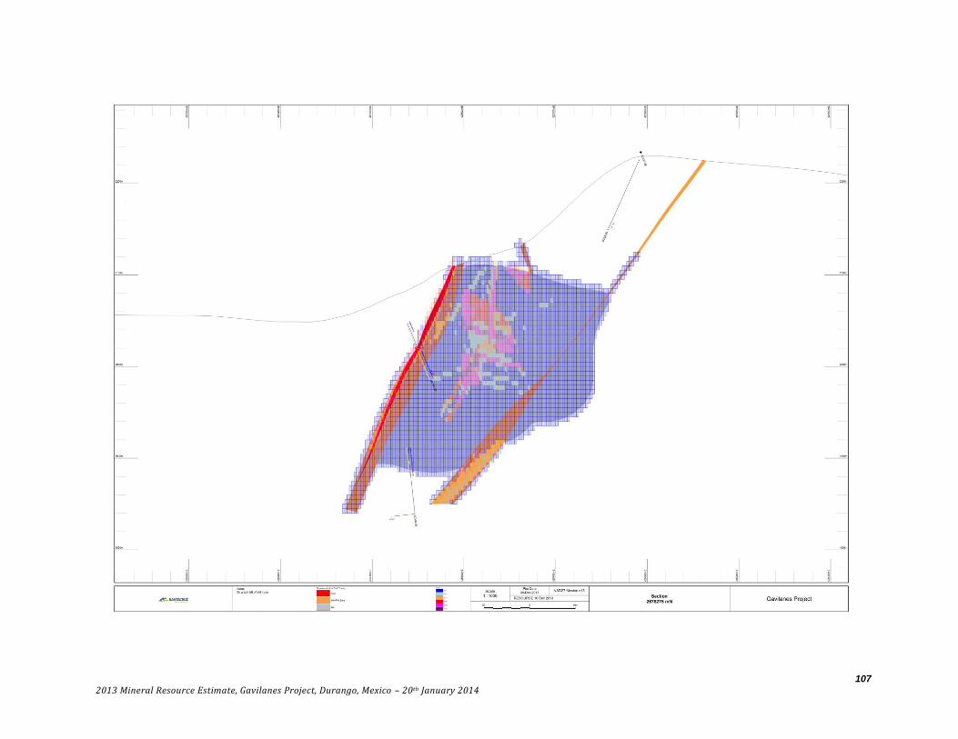
107
2013 Mineral Resource Estimate, Gavilanes Project, Durango, Mexico – 20th January 2014

108
2013 Mineral Resource Estimate, Gavilanes Project, Durango, Mexico – 20th January 2014
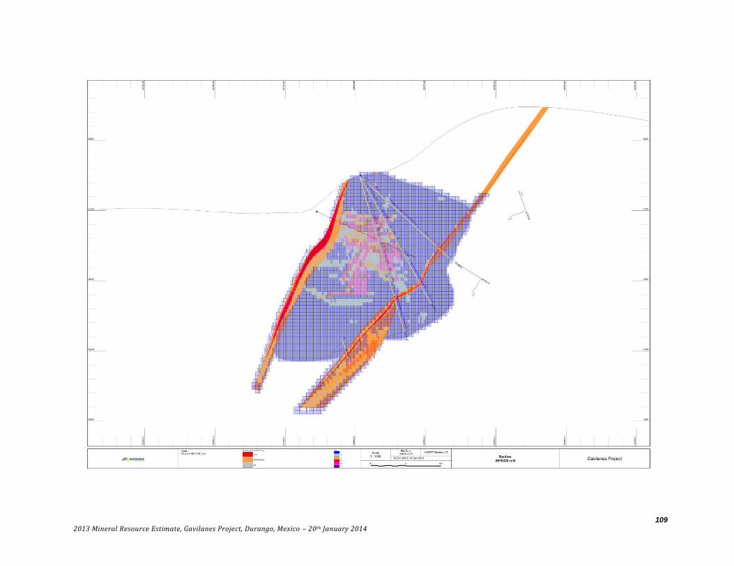
109
2013 Mineral Resource Estimate, Gavilanes Project, Durango, Mexico – 20th January 2014

110
2013 Mineral Resource Estimate, Gavilanes Project, Durango, Mexico – 20th January 2014

111
2013 Mineral Resource Estimate, Gavilanes Project, Durango, Mexico – 20th January 2014

112
2013 Mineral Resource Estimate, Gavilanes Project, Durango, Mexico – 20th January 2014

113
2013 Mineral Resource Estimate, Gavilanes Project, Durango, Mexico – 20th January 2014

114
2013 Mineral Resource Estimate, Gavilanes Project, Durango, Mexico – 20th January 2014
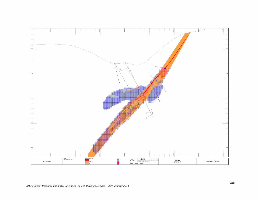
115
2013 Mineral Resource Estimate, Gavilanes Project, Durango, Mexico – 20th January 2014
116
2013 Mineral Resource Estimate, Gavilanes Project, Durango, Mexico – 20th January 2014

117
2013 Mineral Resource Estimate, Gavilanes Project, Durango, Mexico – 20th January 2014

118
2013 Mineral Resource Estimate, Gavilanes Project, Durango, Mexico – 20th January 2014

119
2013 Mineral Resource Estimate, Gavilanes Project, Durango, Mexico – 20th January 2014
120
2013 Mineral Resource Estimate, Gavilanes Project, Durango, Mexico – 20th January 2014

121
2013 Mineral Resource Estimate, Gavilanes Project, Durango, Mexico – 20th January 2014

122
2013 Mineral Resource Estimate, Gavilanes Project, Durango, Mexico – 20th January 2014

123
2013 Mineral Resource Estimate, Gavilanes Project, Durango, Mexico – 20th January 2014

124
2013 Mineral Resource Estimate, Gavilanes Project, Durango, Mexico – 20th January 2014
125
2013 Mineral Resource Estimate, Gavilanes Project, Durango, Mexico – 20th January 2014
126
2013 Mineral Resource Estimate, Gavilanes Project, Durango, Mexico – 20th January 2014

127
2013 Mineral Resource Estimate, Gavilanes Project, Durango, Mexico – 20th January 2014

128
2013 Mineral Resource Estimate, Gavilanes Project, Durango, Mexico – 20th January 2014

129
2013 Mineral Resource Estimate, Gavilanes Project, Durango, Mexico – 20th January 2014

130
2013 Mineral Resource Estimate, Gavilanes Project, Durango, Mexico – 20th January 2014

131
2013 Mineral Resource Estimate, Gavilanes Project, Durango, Mexico – 20th January 2014