2014 geology research day - california state university ... · 2014 geology research day ... aaron...
TRANSCRIPT

2014 GeologyResearch Day
Abstract Volume Department of Geological Sciences
California State University, Fullerton
Titan Student Union - Garden Café, April 25, 2014
Cal State Fullerton GEOLOGY
2014 GeologyResearch Day

2 | P a g e
The Department of Geological Sciences at California State University, Fullerton is an
interdisciplinary education and research community whose members are active mentors and role-models. Our mission is to provide a student-centered educational and research experience that emphasizes critical thinking, communication, and scientific citizenship.
‘Research Day’ is an extension of this mission, where students are afforded the
opportunity to share their research findings and scientific experiences with faculty, student peers, friends, family, and members of the professional geological community in
an informal and supportive environment. Thank you for participating in this year’s event!

3 | P a g e
5th Annual Geology Research Day ~ California State University, Fullerton ~
Department of Geological Sciences Titan Student Union Garden Café
April 25, 2014
Abstract Volume Table of Contents Undergraduate Proposal Category Using Ostracods in Silver Lake, California to Reconstruct Past Hydrologic Variability Student: Andrea Arevalo Faculty Advisor: Dr. Matthew E. Kirby Drilling Methodology and Field Guide and Its Use for the Drilling Industry Student: Nancy Ibarra Faculty Advisor: Dr. Richard Laton Correlation of Last Chance Range Basalts in Death Valley, California, by X-ray Fluorescence Spectroscopy (XRF) Student: Jacob Kato Faculty Advisor: Dr. Jeffrey Knott Undergraduate Thesis Category Assessing a Late Triassic Fossil Sponge Reef Mound to Further Understand the Shift from Paleozoic Fauna to Modern Fauna Student: Mihai Agiu Faculty Advisor: Dr. Nicole Bonuso New Specimens of Leatherback Sea Turtles (Dermochelyidae) from the Miocene of Orange County Shed Light on Morphological Trends Student: Katrina Awalt Faculty Advisor: Dr. James Parham Paleoecology and Shallow Marine Taphonomy of a Late Pleistocene Whale Fall Habitat on the Southern California Coast Student: Lorainne Benton Faculty Advisor: Dr. Nicole Bonuso Geochemical Correlation of Basalts in Northern Deep Springs Valley, California, by X-Ray Fluorescence Spectroscopy (XRF) Student: Aaron Justin Case Faculty Advisor: Dr. Jeffrey Knott

4 | P a g e
Paleotsumani Research with Possible Evidence of Subsidence at the Seal Beach Wetlands, Seal Beach, CA Student: D’Lisa O’hara Creager Faculty Advisor: Dr. Brady Rhodes Possible Shell-Hash Tsunami Deposit at the Los Penasquitos Marsh, San Diego County, CA Student: Jeremy Cordova Faculty Advisor: Dr. Brady Rhodes Wetlands Delineation Using Dendrochronology and Historical Rainfall Data to Crossdate the Climatic Stress Regimes in the Prado Dam Basin Located in Corona, Riverside County, California Student: Lucy Cortez Faculty Advisor: Dr. Richard Laton Dip of the Sierra Nevada Frontal Fault zone in the Vicinity of Lone Pine, California: Steep or Shallow? Student: Brian Gadbois Faculty Advisor: Dr. Phil Armstrong Searching for a Paleotsunami Record at Seal Beach, Southern California Student: Dylan Garcia Faculty Advisor: Dr. Matthew Kirby Geochemical analysis of Dome 7403 to determine magma depth and its relationship to the Bishop Tuff and “Early” Rhyolites, Long Valley Caldera, Sierra Nevada, California Student: Matthew Hutchinson Faculty Advisor: Dr. Brandon Browne Geology of a Tertiary Intermontane Basin of the Last Chance Range, NW Death Valley National Park, California Student: Christopher Johnson Faculty Advisor: Dr. Jeffrey Knott Understanding the Orientation of the Sierra Nevada Frontal Fault System in the Vicinity of Lone Pine and Independence, CA Student: Garrett Mottle Faculty Advisor: Dr. Phil Armstrong Debris Flow Deposits On Starvation Canyon Alluvial Fan, Death Valley, California Student: Kelly Shaw Faculty Advisor: Dr. Jeffrey Knott

5 | P a g e
Reconstruction of Hydrologic Changes During the Last 96,000 Years Using Sediments from Baldwin Lake, San Bernardino County, California Student: Emily Silveira Faculty Advisor: Dr. Matthew Kirby Petrographic and geochemical analysis of the Summit Gabbro and associated granitoids of the Kern Plateau, Southern Sierra Nevada, California Student: Elizabeth White Advisor: Dr. Diane Clemens-Knott Graduate Proposal Category A Paleoecological Study of the Middle and Late Triassic within Favret Canyon, West-Central Nevada Student: Edween Hernandez Faculty Advisor: Dr. Nicole Bonuso X-Ray Diffraction Analysis on Phayao Lake Sediments Student: Christine Hiner Faculty Advisor: Dr. Brady Rhodes Ten Million Years of Bird History: a Specimen-Based Approach to Reconstructing the Late Neogene Avifauna of California Student: Peter Kloess Faculty Advisor: Dr. James Parham Does Evidence of Abrupt Coseismic Subsidence Exist in Seal Beach Wetlands Stratigraphy? Student: Robert Leeper Faculty Advisor: Dr. Brady Rhodes A 3,000 year history of precipitation variability in Southern California using sediments from Crystal Lake Student: Jennifer Palermo Faculty Advisory: Dr. Matthew Kirby
6 | P a g e
Graduate Thesis Category Complex ichnofabrics in the Lower Member of the Union Wash Formation, California: Limited recovery from the Permian – Triassic mass extinction Student: Paul Alms Faculty Advisor: Dr. Adam Woods Late Holocene Hydrologic Reconstruction Using Lake Sediments from Abbott Lake, California Student: Christine Hiner Faculty Advisor: Dr. Matthew Kirby Deciphering Biotic Responses to Rapid Climate Change at the Plio-Pleistocene Boundary Student: Bethany Malenick Faculty Advisor: Dr. Nicole Bonuso A Paleoceanographic Analysis of the Ely Springs Dolomite, East-Central California: Constraining the Duration of the Hirnantian Glaciation Student: William Pilesky Faculty Advisor: Dr. Adam Woods Environmental Science Research in Thailand Category The Presence of Fluoride in the San Kamphaeng Water System in Chiang Mai, Thailand Presenters: D’lisa O. Creager, Fongsaward S. Singharajwarapan, and Brady P. Rhodes Debris Flow Hazards in the Pai Valley, Northern Thailand Presenters: Garcia, D.J., Shaw, K., Rhodes, B.P., Chantraprasert, S. Gravity Mapping the Ban Pong Basin Presenter: Billy Pilesky

7 | P a g e
Undergraduate Proposal Category

8 | P a g e
Using Ostracods in Silver Lake, California to Reconstruct Past Hydrologic Variability Student: Andrea Arevalo Faculty Advisor: Dr. Matthew E. Kirby Abstract
Within the Holocoene, Silver Lake has undergone dramatic hydrologic changes reflecting regional
climate variation of the Mojave Desert. (M.E. Kirby et al, 2002). Ostracods, serving as the proxy in this
paper, deliver these relationships during this time allowing for paleohydrologic reconstruction. Data
suggests a gradual trend of times of colder and wetter climate to warmer and dyer climate. Conditions
became unfavorable for ostracod growth as Silver Lake transitioned from an ephermal lake to its present
day state, a playa lake. This regions weather is greatly influenced by Pacific Ocean interactions,
introducing pluvial events due to atmospheric river storms, which ultimately change the typical conditions
at which lakes can be maintained. Such events promote wetter winters, allowing for longer high lake
level standings (M.E. Kirby et al, 2002). Ostracod data was plotted comparatively over interglacial and
glacial periods of the Holocene. Our data displays synchronized changes, recording events such as the
Younger Dryas. Understanding the relationships between climate and hydrologic responses allows for
proper accommodating for deficiencies in our water budget of Southern California.

9 | P a g e
Drilling Methodology and Field Guide and Its Use for the Drilling Industry Student: Nancy Ibarra Faculty Advisor: Dr. Richard Laton Abstract
Water is an essential part of life and with the increasing population the need for clean potable water is
increasing at a greater rate. Drilling is a necessary component in the extraction of water and this makes it
an essential element of our society. There are various methods of drilling and their use is dependent on
many factors such as geology and cost limits. For experienced and non-experienced drillers alike
choosing a method can be time-consuming and difficult. This undergraduate thesis consists of making a
website compatible to the needs of the drilling industry. The information gathered will be defined
thoroughly and categorized by method within a website and should make an adequate field guide for
drillers, geologists, and engineers. The website can be browsed and the guest can evaluate which method
is the best choice for their project. The content is being gathered from lectures given in advanced
hydrogeology courses, books, drilling company contributions, and Dr. Richard Laton’s experience. This
data can be easily accessible without the need of a textbook. The website will list drilling methods, their
advantages, disadvantages, and the development of well installation as well as other related topics. It will
also discuss tools and techniques related with well development such as casing, pipes, bits and well
installation. This website can be a tool that contributes to improving the drilling industry, a necessary
component of our water industry.

10 | P a g e
Correlation of Last Chance Range Basalts in Death Valley, California, by X-ray Fluorescence Spectroscopy (XRF) Student: Jacob Kato Faculty Advisor: Dr. Jeffrey Knott
Abstract
The Last Chance Range is located in the Northern part of the Death Valley region. Evidence using
basaltic flows has shown that there is a fluvial correlation between Owens Valley and Death Valley.
These basaltic flows are found within valleys and on the peaks of the Inyo and Last Chance Ranges.
Gravity would dictate in the past, these basaltic flows would have traveled down river channels. To
determine the flow, samples of basalt will be taken from the Last Chance Range. Samples will be made
into a powder and then analyzed for major trace elements using an X-ray Fluorescence Spectrometer
(XRF). Geochemical data will then be compared with other basaltic flow data to analyze the topography
of the fluvial environment during the Pliocene in Death Valley and Owens Valley.

11 | P a g e
Undergraduate Thesis Category

12 | P a g e
Assessing a Late Triassic Fossil Sponge Reef Mound to Further Understand the Shift from Paleozoic Fauna to Modern Fauna Student: Mihai Agiu Faculty Advisor: Dr. Nicole Bonuso Abstract
This study will examine a fossil sponge reef mound recently located in New Pass Range, Central Nevada,
in order to document reef dynamics for further understanding of how reefs became modernized. The
reappearance of reefs in an ecosystem often serves as a marker for the end of recovery. After the end-
Permian mass extinction (approximately 252 million years ago), in which about 96 percent of all marine
species perished, secondary reef-building organisms, such as sponges, recovered initially as the primary
reef-builders. Marine organisms from the past died out and new, more modern organisms took their place.
The sponge reefs are intermediate between the "Paleozoic" fauna prior to mass extinction, and "modern"
fauna. Understanding past extinctions and recoveries is significant because of current issues with global
climate change and marine ecosystem degradation. Such information can be used in comparison with
modern crises to help predict possible outcomes, and contribute to conservation initiatives to avoid large-
scale changes in modern marine communities. Research methods include both field and laboratory
procedures: A ten meter high by ten meter long reef mound comprised of limestone, was documented by
using a systematic gridrock sampling scheme. Rock samples were collected from locations where the grid
lines intersect: approximately 25 samples. Rock thin-sections will then be produced to examine and
document the fossils within the rocks. The efforts of understanding the shift from “Paleozoic” fauna to
“modern” fauna will provide insight on marine ecosystem recovery.

13 | P a g e
New Specimens of Leatherback Sea Turtles (Dermochelyidae) from the Miocene of Orange County Shed Light on Morphological Trends Student: Katrina Awalt Faculty Advisor: Dr. James Parham Abstract
The Miocene is a key time in the evolutionary history of leatherback sea turtles, because it marks the last
appearance of archaic thick-shelled forms (Psephophorus spp.). Current knowledge about Miocene
dermochelyids is limited, and mainly based on specimens from Europe and the eastern USA. Recent
studies have raised questions about the taxonomic diversity and biogeographic distribution of Miocene
dermochelyids, and so the description of new specimens from this time, especially from new areas, is key.
Although dermochelyid fossils are known from a few Miocene sites in California, the only published
record is a single femur that was mentioned over 75 years ago (and misidentified as a cheloniid). Many
important specimens from California have been unstudied in museum collections. Over the past decade,
paleontological mitigation at three sites in Orange County resulted in the collection of new, relatively
complete dermochelyid specimens, in combination with more fragmentary specimens from other
California sites, provide new data on the diversity, distribution, and morphology of dermochelyids in the
eastern Pacific. We compare the morphology and stratigraphic position of these specimens to other
Miocene dermochelyids in order to refine the temporal and geographic patterns associated with this
important time in the evolutionary history of leatherbacks. The data show that the transition from archaic
thick-shelled forms to the more thin-shelled forms includes intermediate morphotypes that appear
sequentially within the Miocene marine formations of California.

14 | P a g e
Paleoecology and Shallow Marine Taphonomy of a Late Pleistocene Whale Fall Habitat on the Southern California Coast Student: Lorainne Benton Faculty Advisor: Dr. Nicole Bonuso Abstract
The primary objective of this study is the identification of a boring bivalve species preserved in a
Pleistocene period shallow marine whale fall found in Southern California and currently housed at the
John D. Cooper Paleontological and Archaeological Curation Center. The broader evaluation of the whale
fall serves as a means of reconstructing the paleoecology of the California coast, which assists in
reconstructing the geologic history of this area. The analysis of whale falls and the communities that form
as a result of whale taphonomy is intricately related to exploring the oceans of the past as a whole. There
are three distinct stages of taphonomy for whale falls: a scavenger stage, an enrichment stage, and a
sulphophilic stage. The whale jawbone that is the subject of this project bears trace fossils and two
specimens of boring bivalves, which suggests that the whale fall was buried during the second stage of
taphonomy. Identification of the bivalve species will be based upon the detailed collection of shape,
width, depth, and location data. This data will be compared to the morphology of taxa known to have
inhabited this region in order to confirm identification. Preliminary analysis suggests that the trace fossils
were created by members of the genus Petricola. Three potential species are known to have been active
during the Pleistocene in Southern California, which may account for the trace fossils: Petricola
californiesis, Petricola gracilis parabella, and Petricola tellimyalis. The identification of the
invertebrates that inhabited this particular whale fall will assist in the reconstruction of the shallow marine
habitat during this period of time. In addition, comparing fossil whale fall communities with modern ones
is a significant tool for understanding morphological and population changes in invertebrate species as
well as the whales themselves. This can also allow for a clearer representation of the distribution of
various species by contrasting the types of whales and invertebrates found at different whale falls
throughout the world.
15 | P a g e
Geochemical Correlation of Basalts in Northern Deep Springs Valley, California, by X-Ray Fluorescence Spectroscopy (XRF) Student: Aaron Justin Case Faculty Advisor: Dr. Jeffrey Knott Abstract
In northern Deep Springs Valley (DSV), between Owens Valley and Death Valley, California, Miocene-
Pliocene-age, olivine basalts lie on the valley floor and atop the adjacent White/Inyo Mountains to the
west and the Deep Springs Range to the east. Previous geologic mapping shows the DSV basalt flows and
the Last Chance Range (LCR) basalts found to the southeast are the same geologic unit with a source in
the White/Inyo Mountains. The basalts in northern DSV are offset ~400 m by the Deep Springs fault and
have a K/Ar age of 10.8 Ma.
To determine if the olivine basalts found in the region are all from the same source, four samples were
collected in a linear pattern from west to east across northern DSV. The samples were powdered and
analyzed for major and trace element composition by X-Ray Fluorescence spectrometer (XRF).
Trace-element plots (e.g., Ba, Nb, Zr, Y, Ce, etc.) show that the DSV basalts are similar and are likely
from the same source; however, the composition of the DSV basalts are distinct from the LCR basalts. I
interpret this data by presenting the DSV and LCR basalts have different sources and should not be
mapped as the same geologic unit. The likely source of the DVS basalts is in the White/Inyo Range. The
geochemical correlation shows that the DSV basalts flowed NW to SE in a paleochannel 10.8 Ma and that
DSV did not exist at that time.

16 | P a g e
Paleotsumani Research with Possible Evidence of Subsidence at the Seal Beach Wetlands, Seal Beach, CA Student: D’Lisa O’hara Creager Faculty Advisor: Dr. Brady Rhodes Abstract
The Seal Beach Marsh is located inside the Seal Beach Naval Weapons Station in north Orange County,
CA. The wetland formed as a result of flooding and infilling of topographic lowlands during early
Holocene sea-level rise. The Seal Beach marsh may contain a record of prehistoric tsunami and other
paleoseismic data because the marsh is a low-energy depositional environment and historic anthropogenic
disturbance is limited. To test if the marsh has a record of tsunami, sixteen reconnaissance gouge cores
between 150 and 240 cm in length were collected and described in the field. The reconnaissance cores
showed peaty organic layers interbedded with mud and sand. To investigate the stratigraphy at greater
depths, a 377-cm vibracore was collected. Preliminary analyses of the vibracore show the top 15 cm is
modern marsh. From 15 to 107 cm below land surface (bls), peaty mud and mud of varying thicknesses
are interbedded. At 118 cm bls, a 10-cm thick sand layer covers mud at a sharp irregular contact. A 10-cm
sand layer with an irregular basal contact at 137-cm bls covers peaty mud that consists of 50% organic
matter. Peaty mud transitions to mud at 140 cm bls. Alternating mud and muddy sand layers of varying
thickness continue to 246 cm bls. At 250 cm bls, a 2-cm thick mud layer caps a muddy peat layer. Mud at
270 cm bls extends down until a sharp irregular contact is made with a sand layer at 356 cm. A 21-cm
thick sand layer marks the base of sediment recovery in the vibracore. The core was analyzed for loss on
ignition (LOI) at 550°C (% total organic matter) and 950°C (% total carbonate) as well as magnetic
susceptibility (CHI) at 1-cm intervals. These analyses confirm the existence of several organic-rich zones
alternating with organic-poor mud. Our working hypothesis is that these peaty layers represent repeated
subsidence of the marsh, perhaps related to seismic activity on the Newport-Inglewood Fault zone.

17 | P a g e
Possible Shell-Hash Tsunami Deposit at the Los Penasquitos Marsh, San Diego County, CA Student: Jeremy Cordova Faculty Advisor: Dr. Brady Rhodes Abstract
The Los Penasquitos Marsh is one of a series of coastal wetlands between San Diego and Orange County
that formed within stream valleys that flooded and filled with sediment during Holocene sea-level rise. In
order to test the hypothesis that these wetlands contain prehistoric tsunami deposits, within the normal
wetland sediments, 21 reconnaissance cores between 48 and 321cm in length were collected and
described in the field. Nearly all the sediment cores contained a peaty layer in the top 5-25cm, underlain
by dark brown and black mud, above interbedded fine-medium gray sand and mud. The stratigraphy in
the cores is consistent with the complete infilling of a lagoon behind a baymouth bar of sand, a 'drowned
river valley'. Five of the cores taken, ranging from 1.0-1.5 km inland from the present day beach,
intersect a distinctive 0.5 – 12.0 cm-thick shell-hash and muddy sand layer between 233 and 280cm
depth.
Based on this discovery we collected a 285cm long 5cm diameter piston core to further analyze this
possible tsunami deposit. In this larger core the 10 cm-thick shell hash layer consists of angular shell
fragments up to 3cm in size, in a muddy sand matrix that includes the following genera: Mitrella, Venus,
Spirotropis, Pecten, Nassarius, Macoma, and an unidentified oyster. This fossil assemblage suggests a
quiet water marine source for the shell hash debris– from the lagoon and/or offshore, not typical of low
energy fine grained comparatively well sorted wetland sediments. The core was analyzed for loss on
ignition (LOI) at both 550° and 950°C and magnetic susceptibility (ms). The LOI550 data are
unremarkable, and the LOI950 data show an expected spike in mass percent of carbonates within the
shell-hash layer. The ms data show low values for the lagoonal muds and sands, but a pronounced spike
within the shell hash layer, where the average reading more than doubles from 2.0 to 4.6. We hypothesize
that the anomalously high ms value for the shell hash layer indicates a substantial component from an
offshore source, where heavier magnetic minerals accumulated seaward of the baymouth bar, but were
subsequently swept back upland into the lagoon. If correct this layer represents a large-wave event, either
storm or tsunami. Three C-14 dates on shell fragments cluster between 1380-1420 yrs BP, making this
the highest energy event along California's coastline in almost 1500 years.
18 | P a g e
Wetlands Delineation Using Dendrochronology and Historical Rainfall Data to Crossdate the Climatic Stress Regimes in the Prado Dam Basin Located in Corona, Riverside County, California Student: Lucy Cortez Faculty Advisor: Dr. Richard Laton Abstract
In order to better understand the hydrogeology regimes in the Prado Dam Wetlands Basin located in
Corona, California, dendrochronology methods along with historical rainfall data are being used to
crossdate climatic stress conditions. Prado Dam consists of a series of wetlands that received inflow from
storm water flows and natural run-offs throughout the year. Prado Dam currently feed the Santa Ana
watershed and is the key component for the surviving ecosystem that houses endangered species (OCWD,
2013). Dendrochronology is the study of annual-rings-width variations in trees ring to determine past
climatic events (Balouet et al. 2009). The black willow (Salix Nigra) species is native to Prado Dam and
predominantly encompasses the wetland area. For this study the black willow will be the primary species
of interest. Black willow tree ring patterns will be cross-dated with local historical rainfall data to recreate
hydrogeologic and climatic stress conditions. Because trees respond differently to environmental and
climatic conditions, the varying ring patterns in tree cores, narrow and wide, result from growth in
varying climatic conditions. Therefore, trees growing in similar environmental conditions will record the
similar environmental conditions (Phipps, 1985). Further research is expected to support the varying tree
ring width growth patterns with local climatic stressors.
19 | P a g e
Dip of the Sierra Nevada Frontal Fault zone in the Vicinity of Lone Pine, California: Steep or Shallow? Student: Brian Gadbois Faculty Advisor: Dr. Phil Armstrong Abstract
The Sierra Nevada Frontal Fault Zone (SNFFZ) includes a series of east-dipping normal faults located at
the eastern front of the Sierra Nevada Mountains. According to Byerlee's law, optimal dip for normal
faults is 60˚-70˚; therefore, it generally is assumed that SNFFZ normal faults also dip ~60˚. Estimates of
late Pleistocene to Holocene horizontal extension rates are 0.2-0.3 mm/yr, but these estimates are based
on a 60˚ dipping fault system. Recent studies near Bishop show that many faults of the SNFFZ dip 29˚-
46˚. If these shallow dips are correct, then long-term horizontal extension rates based on 60˚ dips should
be recalculated because the horizontal component of slip could increase as much as four-fold. This study
focuses on faults of the SNFFZ exposed at Tuttle Creek in the vicinity of Lone Pine. Reconnaissance
mapping and fault evaluation suggest that exposed bedrock faults, faults cutting Quaternary alluvial
surfaces, and fracture systems dip as low as 29˚ E. New data collected using detailed differential GPS
measurements across ~300 m of elevation change, from which 3-D fault orientations will be evaluated,
will help constrain the SNFFZ orientation further.
20 | P a g e
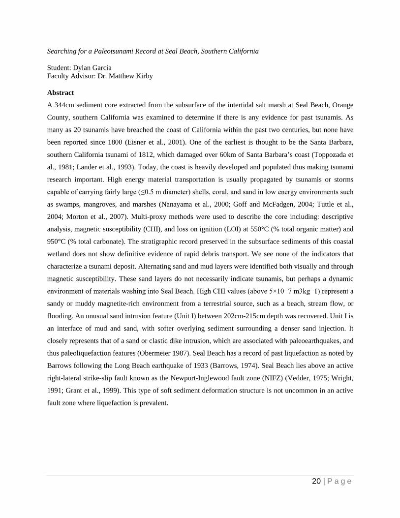
Searching for a Paleotsunami Record at Seal Beach, Southern California Student: Dylan Garcia Faculty Advisor: Dr. Matthew Kirby Abstract
A 344cm sediment core extracted from the subsurface of the intertidal salt marsh at Seal Beach, Orange
County, southern California was examined to determine if there is any evidence for past tsunamis. As
many as 20 tsunamis have breached the coast of California within the past two centuries, but none have
been reported since 1800 (Eisner et al., 2001). One of the earliest is thought to be the Santa Barbara,
southern California tsunami of 1812, which damaged over 60km of Santa Barbara’s coast (Toppozada et
al., 1981; Lander et al., 1993). Today, the coast is heavily developed and populated thus making tsunami
research important. High energy material transportation is usually propagated by tsunamis or storms
capable of carrying fairly large (≤0.5 m diameter) shells, coral, and sand in low energy environments such
as swamps, mangroves, and marshes (Nanayama et al., 2000; Goff and McFadgen, 2004; Tuttle et al.,
2004; Morton et al., 2007). Multi-proxy methods were used to describe the core including: descriptive
analysis, magnetic susceptibility (CHI), and loss on ignition (LOI) at 550°C (% total organic matter) and
950°C (% total carbonate). The stratigraphic record preserved in the subsurface sediments of this coastal
wetland does not show definitive evidence of rapid debris transport. We see none of the indicators that
characterize a tsunami deposit. Alternating sand and mud layers were identified both visually and through
magnetic susceptibility. These sand layers do not necessarily indicate tsunamis, but perhaps a dynamic
environment of materials washing into Seal Beach. High CHI values (above 5×10⁻⁷ m3kg−1) represent a
sandy or muddy magnetite-rich environment from a terrestrial source, such as a beach, stream flow, or
flooding. An unusual sand intrusion feature (Unit I) between 202cm-215cm depth was recovered. Unit I is
an interface of mud and sand, with softer overlying sediment surrounding a denser sand injection. It
closely represents that of a sand or clastic dike intrusion, which are associated with paleoearthquakes, and
thus paleoliquefaction features (Obermeier 1987). Seal Beach has a record of past liquefaction as noted by
Barrows following the Long Beach earthquake of 1933 (Barrows, 1974). Seal Beach lies above an active
right-lateral strike-slip fault known as the Newport-Inglewood fault zone (NIFZ) (Vedder, 1975; Wright,
1991; Grant et al., 1999). This type of soft sediment deformation structure is not uncommon in an active
fault zone where liquefaction is prevalent.

21 | P a g e
Geochemical analysis of Dome 7403 to determine magma depth and its relationship to the Bishop Tuff and “Early” Rhyolites, Long Valley Caldera, Sierra Nevada, California Student: Matthew Hutchinson Faculty Advisor: Dr. Brandon Browne
Abstract
The cataclysmic eruption of the Bishop Tuff from the Long Valley Caldera 760ka, released ~600 km³ of
rhyolitic magma over one week’s time. This event was followed by a 100,000 year period where ~100
km³ of fairly uniform, crystal-poor rhyolite erupted from within the caldera, known as the Early Rhyolite
(Hildreth, 2004). A sub-circular lava dome located on the NE corner of the Long Valley Caldera floor
formed as a result of continued magmatism in the area. The 0.005 km³ volume dome is unique in that it is
the only non-rhyolitic postcaldera eruptive product produced, differing from other volcanic byproducts
associated with precaldera, caldera-forming (e.g. Bishop Tuff), and other postcaldera eruptions (e.g.
“Early” Rhyolites). Dome 7403 is a small rhyodacite dome with an intermediate composition consisting
of euhedral plagioclase and hornblende phenocrysts. The glassy, columnar dome with two lobes suggests
that it erupted into and was shaped by an intracaldera lake during the Pleistocene. Whole-rock
geochemical analysis of Dome 7403, using x-ray diffraction, shows a lower silica content (66.4% SiO2)
versus “Early” Rhyolites (75% SiO2) and Bishop Tuff (73-78% SiO2). Temperature and pressures of
storage depths that formed Dome 7403 crystals were calculated using compositional analysis from
electron microprobe data and Ridolfi’s calculator to integrate mineral compositions (wt. %) in order to
obtain an Al# and specific amphibole type (magnesio-hornblende). Temperatures for sample 13LVMH-3
(north lobe) ranged from 880 – 970˚C with pressures ranging from 200 – 400 MPa (~7-16 km). Sample
13LVMH-4 (south lobe) had similar temperature ranges (± 20˚𝐶), but had higher pressures ranging from
250 – 450 MPa. The dome was likely a result of another separate and discrete mafic pulse injected
upwards from the upper mantle heating up previous silicic magma. Zoned plagioclase with anorthite rims
compared to albitic cores and reaction rims on hornblendes indicate magma mixing before eruptive event.
Thin reaction rims on hornblende crystals correspond to a rapid ascent (less than a week). Rates of ascent
must be near a maximum rate for the lava Dome 7403 to be present (effusive eruption), otherwise any
quicker, the eruption would have been explosive.
22 | P a g e
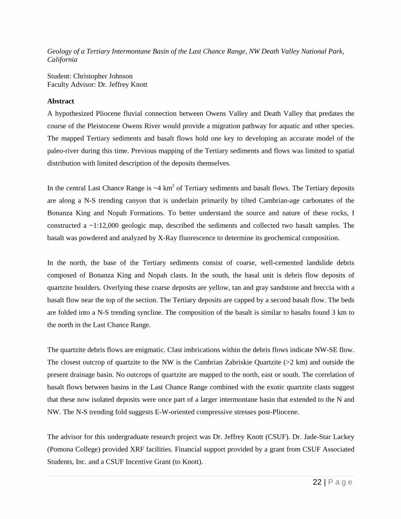
Geology of a Tertiary Intermontane Basin of the Last Chance Range, NW Death Valley National Park, California Student: Christopher Johnson Faculty Advisor: Dr. Jeffrey Knott Abstract
A hypothesized Pliocene fluvial connection between Owens Valley and Death Valley that predates the
course of the Pleistocene Owens River would provide a migration pathway for aquatic and other species.
The mapped Tertiary sediments and basalt flows hold one key to developing an accurate model of the
paleo-river during this time. Previous mapping of the Tertiary sediments and flows was limited to spatial
distribution with limited description of the deposits themselves.
In the central Last Chance Range is ~4 km2 of Tertiary sediments and basalt flows. The Tertiary deposits
are along a N-S trending canyon that is underlain primarily by tilted Cambrian-age carbonates of the
Bonanza King and Nopah Formations. To better understand the source and nature of these rocks, I
constructed a ~1:12,000 geologic map, described the sediments and collected two basalt samples. The
basalt was powdered and analyzed by X-Ray fluorescence to determine its geochemical composition.
In the north, the base of the Tertiary sediments consist of coarse, well-cemented landslide debris
composed of Bonanza King and Nopah clasts. In the south, the basal unit is debris flow deposits of
quartzite boulders. Overlying these coarse deposits are yellow, tan and gray sandstone and breccia with a
basalt flow near the top of the section. The Tertiary deposits are capped by a second basalt flow. The beds
are folded into a N-S trending syncline. The composition of the basalt is similar to basalts found 3 km to
the north in the Last Chance Range.
The quartzite debris flows are enigmatic. Clast imbrications within the debris flows indicate NW-SE flow.
The closest outcrop of quartzite to the NW is the Cambrian Zabriskie Quartzite (>2 km) and outside the
present drainage basin. No outcrops of quartzite are mapped to the north, east or south. The correlation of
basalt flows between basins in the Last Chance Range combined with the exotic quartzite clasts suggest
that these now isolated deposits were once part of a larger intermontane basin that extended to the N and
NW. The N-S trending fold suggests E-W-oriented compressive stresses post-Pliocene.
The advisor for this undergraduate research project was Dr. Jeffrey Knott (CSUF). Dr. Jade-Star Lackey
(Pomona College) provided XRF facilities. Financial support provided by a grant from CSUF Associated
Students, Inc. and a CSUF Incentive Grant (to Knott).

23 | P a g e
Understanding the Orientation of the Sierra Nevada Frontal Fault System in the Vicinity of Lone Pine and Independence, CA Student: Garrett Mottle Faculty Advisor: Dr. Phil Armstrong Abstract
The Sierra Nevada Frontal Fault System (SNFFS) includes a series of east-dipping normal faults along
the eastern front of the Sierra Nevada Mountains in eastern California. Faults there are assumed to dip
~60° east. Late Pleistocene to Holocene horizontal extension rates based on this ~60° dipping fault system
are estimated to be 0.2-0.3 mm/yr. Recent studies on the SNFFS near Bishop, CA show that the faults
there dip more shallowly at 29°-46° east. Another recent study near Independence, CA shows that faults
there dip 29°-34° east. My study was conducted farther south on normal fault exposures near Manzanar
National Historic Site, CA. Sixty data points were collected along the bottom cusp of fault exposures in
offset Quaternary surfaces. Elevations range from ~1780m to ~1890 m over the ~2000 m of fault
exposure. An Excel program was used to model the fault dip assuming a planar fault, and these data
resulted in a 21°-23° east dip. Due to this low-angle normal fault geometry, horizontal extension rates
based on a steeply dipping normal fault system need to be re-evaluated, as extension rates could be
increased by as much as a factor of four.

24 | P a g e
Debris Flow Deposits On Starvation Canyon Alluvial Fan, Death Valley, California Student: Kelly Shaw Faculty Advisor: Dr. Jeffrey Knott Abstract
Three debris fan lobes with volumes of 8-25 million cubic yards were mapped on the Starvation Canyon
alluvial fan in western Death Valley, California. These deposits were mapped atop the ~70 ka Qg2
alluvial fan indicating that the debris flows are younger. Starvation Canyon consists of Tertiary volcanic
rocks at the mouth with faulted Cambrian and Precambrian metamorphic rocks upstream to the west with
the Granite at Hanaupah Canyon is 8.6 km upstream of the piedmont in the headwaters.
Field observations show that the northern lobe of the Qg2 deposits of the Starvation Canyon fan consist of
grusified granite boulders at the surface. The debris flow deposits, which generally line a wash channel,
are composed of 1-6 m diameter, varnished, but relatively unweathered, granite boulders with rare
metamorphic boulders (<2%). The wash channel is incised through the Qg2 deposits with debris flow
boulders overtopping the channel margins and resting atop the Qg2 deposits at the distal end. The
southern lobe of the Starvation Canyon fan is composed of Qg3 gravels with an intervening active
channel (Qg4). Both the younger and active channels are lined with large granite boulders (up to ~9 m
diameter) that are unweathered and have very little, if any, varnish.
Based on the field observations, the conclusion that younger, unweathered granite boulders from debris
flows are found atop the Qg2 gravel is correct. However, field observations are that the debris flow
boulders are limited to the channel and channel margins. This infers that these deposits traveled along the
incised channels and did not overtop the Qg2 gravels, aside from the area at the distal end of the fan.
Thus, the flow volumes were of significantly lower volume than previously thought and, based on the
dominance (>98%) and size (up to ~9 m) of granite boulders these flows would have traveled ~16 km
before being deposited on the Starvation Canyon fan, with the origination point >8 km from the apex of
the fan. The lack of continuity of these debris flows indicates emplacement by multiple events rather than
one large event. This is based on the differences in weathering of the boulders as well as the disconnected
nature of the debris flow deposits. The active channel (Qg4) is comprised of similar debris flow deposits
as are found in the older channels.
25 | P a g e
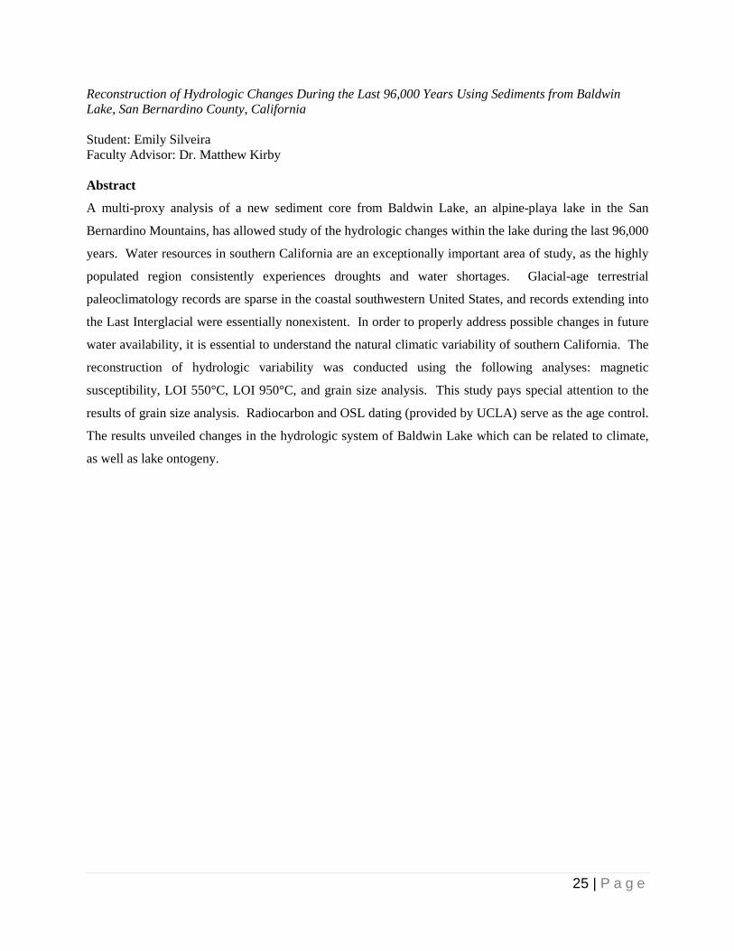
Reconstruction of Hydrologic Changes During the Last 96,000 Years Using Sediments from Baldwin Lake, San Bernardino County, California Student: Emily Silveira Faculty Advisor: Dr. Matthew Kirby Abstract
A multi-proxy analysis of a new sediment core from Baldwin Lake, an alpine-playa lake in the San
Bernardino Mountains, has allowed study of the hydrologic changes within the lake during the last 96,000
years. Water resources in southern California are an exceptionally important area of study, as the highly
populated region consistently experiences droughts and water shortages. Glacial-age terrestrial
paleoclimatology records are sparse in the coastal southwestern United States, and records extending into
the Last Interglacial were essentially nonexistent. In order to properly address possible changes in future
water availability, it is essential to understand the natural climatic variability of southern California. The
reconstruction of hydrologic variability was conducted using the following analyses: magnetic
susceptibility, LOI 550°C, LOI 950°C, and grain size analysis. This study pays special attention to the
results of grain size analysis. Radiocarbon and OSL dating (provided by UCLA) serve as the age control.
The results unveiled changes in the hydrologic system of Baldwin Lake which can be related to climate,
as well as lake ontogeny.

26 | P a g e
Petrographic and geochemical analysis of the Summit Gabbro and associated granitoids of the Kern Plateau, Southern Sierra Nevada, California Student: Elizabeth White Advisor: Dr. Diane Clemens-Knott Abstract
The Sierra Nevada Batholith (SNB) formed from multiple arc magmatism events that occurred as a result
of the collision between the North American and Farallon plates during the Mesozoic Era, 251-65 million
years ago. Arc batholiths, such as the SNB, are important to understand because they record episodes of
continental crustal growth. Calculating the amount of material, in this case magma, transferred from the
mantle to the crust is dependent on the composition of the mantle wedge located beneath the continent.
The amount of chemical evolution that was experienced by a magma can be quantified using the
magnesium number (Mg#), which includes mafic, plutonic rocks called gabbros. Geochemical
characterization of the Summit Gabbro suite from the Kern Plateau provides valuable evidence supporting
that this suite may be used for future studies. Using x-ray fluorescence (XRF) samples Fr-119A, Fr-119B,
and Fr-120C were identified with high Mg#’s of 76.32, 74.33, and 69.32 respectively. These numbers
usually indicate that these magmas have not experienced much differentiation. Petrographic analysis,
however, revealed that Fr-119A and Fr-119B have undergone secondary alteration after crystallization,
making them unsuitable for mantle composition studies. Samples Fr-121B and Fr-123A had Mg#’s of
63.14 and 64.02 respectively, and while they are not mafic enough to be utilized as proxies for the mantle
composition they may be associated with unidentified rocks that are appropriate. Sample Fr-120C has
experienced a minimal amount of chemical-evolution and represents a proxy for the composition of the
mantle source below the batholith. Data analysis of the sodium concentration versus Mg# also seems to
suggest that two distinct magma populations were identified. Sodium concentration may be affected by
amphibole crystallization. This new data set from the Summit Gabbro suite provides insight about the
type of mantle underlying the eastern Sierra Nevada arc and is one of the first steps to determining how
the western margin of the North American continent was modified and expanded by Mesozoic arc
magmatism.
27 | P a g e
Graduate Proposal Category
28 | P a g e
A Paleoecological Study of the Middle and Late Triassic within Favret Canyon, West-Central Nevada Student: Edween Hernandez Faculty Advisor: Dr. Nicole Bonuso Abstract
Paleozoic shallow marine communities hardly resemble present shallow marine communities. Modern
animals such as gastropods and bivalves replaced Paleozoic organisms such as brachiopods and crinoids.
Researchers suggest the end-Permian mass extinction reset the stage by removing past communities, thus
allowing new communities to take over. However, this transition did not occur immediately after the mass
extinction. Once ocean conditions returned to normal in the Middle Triassic, communities stabilized and
took on their new shape. Bivalves increased in diversity and abundance by growing thicker shells and
some began burrowing deep into sediment. Gastropods also increased in diversity and abundance and
grew thicker shells, while some developed new drilling adaptations and became carnivorous. Researchers
suggest that changes in shell thickness and deeper burrowing adaptation occurred as a competitive arms
race between newly evolved predators (eg: marine reptiles and crabs). Scientists describe these changes in
life habit as the Mesozoic Marine Revolution while suggesting that the initiation of this revolution took
place in the Middle and Late Triassic. However, we lack data from the Eastern Panthalassa region (ie.
present day Western North America). My research will provide new paleoecological data to help piece
together the story of how shallow marine communities modernized. The main goal of this project is to
track and document taxonomic and ecologic patterns within an environmental context through time. Once
I document faunal and environmental patterns, I plan on comparing them to determine causal mechanisms
for the observed pattern.
29 | P a g e
X-Ray Diffraction Analysis on Phayao Lake Sediments Student: Christine Hiner Faculty Advisor: Dr. Brady Rhodes Abstract
The Indochina region, consisting of Myanmar, Thailand, Laos, Cambodia, and Vietnam, currently lacks
high-resolution, continuous paleoclimate records. A continuous record from mainland Southeast Asia is
essential in order to better understand past climate variability within this region and predict future
changes. Therefore, a new sediment core was extracted from Phayao Lake in northern Thailand,
approximately 695 km north of Bangkok. A multi-proxy methodology was utilized including loss on
ignition and X-ray Diffraction (XRD). For XRD, a series of four samples were dried, powdered, and
analyzed to assess variations in clay content throughout the core. The results indicate all four samples
contained kaolinite, illite, and chlorite. The presence of these three clays serves as a useful proxy for
different climate regimes. While the presence of illite and chlorite suggest a cold, dry climate, the
presence of kaolinite indicates a wet, humid climate. The conflicting results highlight the need for
quantitative measurements of each type of clay. A comparison of the different clay percentages in a future
project would grant the opportunity to better infer the dominant climate signal at Phayao Lake.
Furthermore, an undergraduate student from Chiang Mai University completed the loss on ignition
component of the project. However, the loss on ignition data is used to reconstruct regional paleoclimate
variability in a separate project.

30 | P a g e
Ten Million Years of Bird History: a Specimen-Based Approach to Reconstructing the Late Neogene Avifauna of California Student: Peter Kloess Faculty Advisor: Dr. James Parham Abstract
California boasts a rich fossil record of Miocene seabirds. Previous studies, based entirely on data from
the literature, have correlated the appearance and disappearance of species to tectonism and climate
change. We are using a specimen-based approach to test and refine diversity patterns derived from the
literature, and describe patterns of relative abundance and occurrence of seabirds through time. The
foundation of our research is a previously unstudied collection of >300 bird specimens from the John D.
Cooper Center for Archaeology and Paleontology. These specimens are from a relatively complete
sequence of strata (“Topanga,” Monterey, and Capistrano Formations) that spans 10 million years of the
Middle Miocene to Early Pliocene. We compare this collection with bird specimens from other
institutions across California in order to provide a more complete and detailed view of avian communities
during this period. For example, our study has found earlier records of gulls (Laridae), grebes
(Podicipedidae), and herons (Ardeidae) in California than were previously known. Our data also show
that, in addition to the previously noted speciation of alcids, the relative abundance of specimens indicates
they dominated the avifauna from the Late Miocene to Early Pliocene. Furthermore, the occurrence of
loons (Gaviidae) is also found to increase during this time. These faunal changes are coincident with
global temperature decrease following the Middle Miocene Climatic Optimum and changing circulation
patterns in the North Pacific resulting from the development of the Isthmus of Panama and movement of
Australia. Previous studies of contemporaneous faunal groups (marine mammals and fish) linked
observed changes in diversity and morphology to nutrient upwelling and the increased abundance of
phytoplankton that results from shifting circulation patterns. The abundance and diversity changes that we
find in the Late Miocene avifauna may also be the result of changing circulation and upwelling in the
region. Built upon the existing literature reviews, this specimen-based approach can develop a more
faithful depiction of the fossil record. Continued study of these collections will yield greater insight into
the complex history of birds during the Late Miocene of California, help us define broader patterns of
faunal change, and correlate these changes to climate and tectonism.
31 | P a g e
Does Evidence of Abrupt Coseismic Subsidence Exist in Seal Beach Wetlands Stratigraphy? Student: Robert Leeper Faculty Advisor: Dr. Brady Rhodes Abstract
The Seal Beach wetlands (SBW) are located along strike of the Newport-Inglewood fault zone (NIFZ) in
northern Orange County, CA. This site is significant due to the wetlands being situated where fault
geometry produces a releasing bend. In wetland environments, abrupt coseismic subsidence may cause an
immediate rise in relative sea level. This change is recorded in the stratigraphy and characterized by
abrupt changes from organic-rich sediment to mud or sand and microfossil assemblages that change
suddenly from brackish to marine. Forty-eight reconnaissance cores collected in the SBW commonly
revealed an upper and lower section of organic-rich sediment interbedded with mud or sandy mud. In
vibracore SB002VC, a 12-cm thick shell-hash layer exists and preliminary microfossil data show that
abrupt changes in diatom assemblages are coincident with abrupt changes in sediment type. A 30-cm long
sand dike injected into overlying organic-rich sediment is present in vibracore SB018VC. To
quantitatively characterize the stratigraphy, multi-proxy analyses have been performed through loss on
ignition at 550°C (% total organic matter) and 950°C (% total carbonate), and magnetic susceptibility
(CHI). Based on field observations and preliminary data, it is hypothesized that the lower section of
organic-rich sediment is the relic marsh surface that subsided during a major prehistoric earthquake on the
NIFZ. Future goals include analyses such as grain size distribution, palynology and Cesium-137
geochronology, while expanding on the micropaleontology work and radiocarbon dating already
completed.

32 | P a g e
A 3,000 year history of precipitation variability in Southern California using sediments from Crystal Lake Student: Jennifer Palermo Faculty Advisory: Dr. Matthew Kirby Abstract
In Southern California the amount of seasonal precipitation is controlled by the winter season, making it
of particular importance to the densely populated region to understand past precipitation variability. As a
result of the seasonal distribution of precipitation, any change in the amount of winter season precipitation
has a significant impact on Southern California’s annual hydrologic budget. Because measured
precipitation records for Southern California are scarce, not well resolved, and extend back only 200
years, this study aims to reconstruct a high resolution history of past precipitation variability, including
droughts and floods, for the past 3000 years in Crystal Lake, CA. Crystal Lake is one of the few, natural
lakes in Southern California. The lake is relatively small in size, 0.1 kilometers across the widest
dimension and 0.23 kilometers across the longest dimension, and only 6.4 meters deep, as of 2003.
Located 1650 meters above sea level in the Angeles National Forest of the San Gabriel Mountains, the
lake is hydrologically closed, fed only by groundwater springs, snowmelt, and direct precipitation run-off;
evaporation is the only source of water loss. This study will utilize the chemical and physical
characteristics of lake sediments from Crystal Lake – sediments from natural lakes provide excellent
records of past precipitation variability. Two Livingston piston cores will be obtained from the basin, one
from the depocenter and one from the littoral zone, and correlated using mass magnetic susceptibility
(MS) and loss on ignition (LOI) for spatial continuity. LOI 550° and 950° will measure total organic
matter and total carbonate, respectively. The sediment cores will also be sampled for grain size analysis
and carbon:nitrogen ratios. Radiocarbon-14 dates will provide a temporal scale for the study. After
determining episodes of wet and dry climates in Crystal Lake, our record will be compared to other
regional records to better understand the mechanisms that are driving climatic changes in Southern
California, such as ocean-atmosphere interactions like El Niño Southern Oscillation or Pacific Decadal
Oscillation.
33 | P a g e
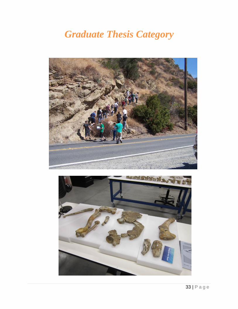
Graduate Thesis Category

34 | P a g e
Complex ichnofabrics in the Lower Member of the Union Wash Formation, California: Limited recovery from the Permian – Triassic mass extinction Student: Paul Alms Faculty Advisor: Dr. Adam Woods Abstract
Signs of biological recovery typically appeared quickly after most of the mass extinctions in Earth’s
history. Delayed recovery following the Permian-Triassic mass extinction is thought to be due to unusual
oceanic conditions, including anoxia and hypercapnic stresses, which persisted from the Permian-Triassic
boundary until the end of the Early Triassic. In areas where oceanic conditions returned to normal,
however, organisms recovered at normal Phanerozoic rates. The thin-bedded limestones and silty
limestones of the Dienerian-Smithian Lower Member and Middle Member of the Union Wash Formation
near Darwin, California are characteristic of shallow shelf and middle to outer shelf environments,
respectively, and were examined in order to better establish the relationship between biotic recovery and
environmental conditions. The Lower Member of the Union Wash Formation shows extensive biologic
activity in the form of abundant Thalassinoides trace fossils. The upper portion of the Lower Member
and the Middle Member of the Union wash Formation show a return to stressful oceanic conditions,
reflected in the rock record by the presence of finely laminated facies, seafloor precipitates, and a lack of
metazoan fossils. The bioturbated beds of the Lower Member of the Union Wash Formation were
examined to determine the extent of the biologic recovery during the Early Triassic, using the ichnofabric
index of the tops and sides of bedding planes and burrow diameter as recovery proxies. Despite the
presence of complex ichnofabrics, the small burrow diameters and monotypic trace fossil type of the
Lower Member of the Union Wash Formation indicate that only limited recovery occurred in the shallow
shelf environment, and was ultimately squelched when anoxic waters flooded the area. The results of this
study suggest that the presence or absence of harsh environmental conditions was a strong control for
determining the timing of biotic recovery, and limited recoveries were limited to “false starts” if
environmental conditions deteriorated.
35 | P a g e
Late Holocene Hydrologic Reconstruction Using Lake Sediments from Abbott Lake, California Student: Christine Hiner Faculty Advisor: Dr. Matthew Kirby Abstract
A multi-proxy study on a new sediment core collected from Abbott Lake, California is used to reconstruct
hydrologic variability during the Medieval Climate Anomaly (MCA) and Little Ice Age (LIA) (2,000 cy
BP to the present). Since Abbott Lake is one of only a few natural, permanent lakes between coastal
southern and central California, it serves as an important location for extending the knowledge of past
hydrologic variability along the coast of western United States as well as constraining the spatiotemporal
variation of the hydroclimatic dipole characterizing this region. A series of analyses were used to infer
past climate conditions within the lake and its drainage basin including magnetic susceptibility, loss on
ignition, grain size, and δ13C and δ18O isotopic analysis of Gyraulus parvus shells. The results reveal
central coastal California was characterized by a relatively warm, dry climate regime during the MCA and
a cool, wet climate during the peak of the LIA. Hydrologic variability in this region is driven by northern
Pacific Ocean-atmosphere dynamics, specifically Pacific Decadal Oscillation (PDO), rather than tropical
Pacific Ocean forcings such as El Niño Southern Oscillation (ENSO). Furthermore, a comparison to the
Castor-Lime Lake record in eastern Washington reveals the position of the dipole has shifted relative to
Abbott Lake multiple times over the past 1,500 cy BP. However, the dipole has maintained its modern
position north of Abbott Lake since 220 cy BP.

36 | P a g e
Deciphering Biotic Responses to Rapid Climate Change at the Plio-Pleistocene Boundary Student: Bethany Malenick Faculty Advisor: Dr. Nicole Bonuso Abstract
The Pliocene-Pleistocene transition is a dynamic period for taxonomic loss and origination resulting from
the closing of the Panama Isthmus. Evidence from the Atlantic and Pacific Oceans indicates that this
tectonic change altered ocean circulation patterns redistributing sea surface temperature (SST) and
nutrient availability globally. It is unknown how eastern Pacific marine invertebrate taxa responded to
those oceanic changes. This study aimed to document changes in marine invertebrate community
diversity and abundance in response to a hypothesized decrease in SST and increase in nutrient
availability at the Plio-Pleistocene boundary. Samples were collected from 9 fossil beds within the San
Diego Formation, Tourmaline Surf Park, San Diego County, CA. Foraminifera biostratigraphy confirmed
the location of the Pliocene-Pleistocene at the project site. The collected samples were identified and
diversity and abundance were calculated. While diversity declined into the Pleistocene, abundance levels
varied sporadically. To determine the variables controlling changes in diversity and abundance SST was
tracked via Stable Isotope Analysis and nutrient availability was recorded via Ba/Ca ratios calculated
through Inductively Coupled Plasma Optical Emission Spectrometry (ICP-OES). Results indicated that
SST decreased during this interval, while nutrient availability increased. NMDS, Clustering Analysis,
and ANOSIM were used to statistically determine differences between the San Diego Formation Plio-
Pleistocene fossil beds and known Pleistocene fossil sites in Orange and Los Angeles Counties. The
statistical results confirm that there are significant differences between the Pliocene and Pleistocene
horizons. The Plio-Pleistocene boundary provides a unique laboratory to examine how environmental
change affects life on Earth and can provide direct insights into our present-day biodiversity crisis for two
reasons: 1) many Plio-Pleistocene taxa are extant thus providing a direct prediction of how modern taxa
might respond to rapid climate change; and 2) the proposed environmental analyses provides a more
rigorous and detailed analysis then previous studies thus providing a more direct comparison with modern
climate patterns.

37 | P a g e
A Paleoceanographic Analysis of the Ely Springs Dolomite, East-Central California: Constraining the Duration of the Hirnantian Glaciation Student: William Pilesky Faculty Advisor: Dr. Adam Woods Abstract
In order to better understand the mechanics behind modern climatic change, other periods in Earth history
when rapid temperature shifts had a substantial effect on Earth’s biota need to be examined. The End-
Ordovician mass extinction likely resulted from climatic cooling associated with Hirnantian (latest
Ordovician) glaciation, which invigorated ocean circulation and altered ocean chemistry far from the ice
sheet. Examination of the Ely Springs Dolomite (east-central California) provides a means to study the
effects of shifts in ocean circulation on Earth’s tropical biota during an interglacial period and constrain
the duration of the Hirnantian glaciation by determining how long changes in ocean circulation persisted.
The Ely Springs Dolomite was examined at two localities; Willow Spring Canyon (Mazourka Canyon),
CA and Talc City Hills, CA. At Talc City Hills, the Ely Springs Dolomite contains abundant crinoid
columnals scattered throughout the unit, rugose corals near the base, and storm deposits consisting of
crinoid hash beds near the Ordovician-Silurian boundary. The change in fauna is indicative of a shift from
warm, tropical waters to cool waters that were introduced to the shelf via upwelling. At Willow Spring
Canyon, the formation is divided into three informal members: an Upper Ordovician member consisting
of chert-rich dolostone; a middle, lowermost Silurian member consisting of massive dolostone; and an
upper, Lower Silurian member consisting of interbedded cherty dolostone and thick chert beds. This
sequence records a drop in sea level followed by a relative rise in sea level caused by the glaciation and
deglaciation of Gondwana, while the chert-rich nature of the unit is indicative of vigorous ocean
circulation, upwelling, and high primary productivity. Initial trace element geochemistry and lithologic
analysis of the Ely Springs Dolomite suggest that upwelling and high primary productivity were present
during deposition of much of the formation, demonstrating that vigorous ocean circulation was persistent
and driven by a long-lived Gondwanan glaciation.

38 | P a g e
Environmental Science Research in Thailand Category
39 | P a g e
The Presence of Fluoride in the San Kamphaeng Water System in Chiang Mai, Thailand Presenters: D’lisa O. Creager, Fongsaward S. Singharajwarapan, and Brady P. Rhodes Abstract
The San Kamphaeng hot springs are located near Chiang Mai, a major city in northern Thailand. The
area is filled with extensive north-south oriented fault zones. When these fault zones occur over a heat
source, groundwater fluid and surface water travel downwards where they are sequentially heated up and
allowed to interact with other fluids. The new heated fluid journeys back upward towards the surface via
fractures in the rock and expelled through a hot spring. Fluids within this system can interact with the
surrounding groundwater and surface water. The San Kamphaeng hot spring fluids have a history of
exhibiting high fluoride levels. The high fluoride content could potentially be seen in the surrounding
groundwater and surface water, allowing us to determine if the hot spring fluid is interacting with these
systems. Water samples were taken from the hot spring, up stream and down stream from two creeks
surrounding the hot spring, and also from ground water wells. The pH, temperature and GPS
coordinates were recorded for each sample. The samples were then chemically analyzed for their fluoride
content and total dissolved solids. A simple groundwater map was constructed using three groundwater
elevations in order to discern the direction of groundwater flow. The fluoride content of the hot spring
fluids was then compared to that of the ground water and creek water. This coupled with the direction of
surface water and ground water flow revealed the nature of the interaction between the systems.

40 | P a g e
Debris Flow Hazards in the Pai Valley, Northern Thailand Presenters: Garcia, D.J., Shaw, K., Rhodes, B.P., Chantraprasert, S. Abstract
In this study we look at past mass wasting events in the Pai Valley of Northern Thailand to better
understand the size and scope of previous slide events. Thailand is located in southeast Asia, sharing
borders with Burma, Laos, Cambodia, Malaysia, The Andaman Sea and The Gulf of Thailand. Pai Valley
is in the northernmost region of Thailand, close to the Burmese border. Research on past slides in this
area is significant because of the population living on these slides. The inhabitants of Pai had an estimated
population of about 2,284 as of 2006 (www.geonames.org). Residents built their homes on the suspected
slide area and are dependent on the agriculture grown on the slides. A future slide event could be
catastrophic for the valley, including major loss of life. It is hypothesized that in the past there was a
massive debris flow that originated west of the valley. Our research shows the suspected slides are
“Torrent Slides,” or “Long Slides.” These are channelized type slides discharging water and debris
composed of bedrock, unconsolidated sediment or organic material and can be triggered by changes in
ground water conditions or the geometry of the slope. Given the tropical setting of the area, it is presumed
these slides were triggered by excessive rains or unseasonably wet periods. Through satellite imagery and
on the ground mapping we determined at least two slide events and possibly a third. The mapping process
involved driving and looking for locations with boulders versus bedded areas. When we determined the
end of the boulder section and beginning of bedding, we plotted the location on our map. We continued
until we had the boundaries of the slide determined. Clast counts were performed at a number of locations
within the slide area. At each location an average of 50 clasts were counted, classified and measured.
Sizes ranged from sand grain to 16 meters. The main lithologies of the clasts were granite and sandstone,
this is expected if the slides originated west of the valley. There was no clear difference in weathering
from one location to the next which leads us to believe these events occurred in a relatively short time
frame. Future research could determine the precise origins of the slides and cosmogenic dating could be
helpful in determining how old the slides are.

41 | P a g e
Gravity Mapping the Ban Pong Basin Presenter: Billy Pilesky Abstract
The Ban Pong Basin is located in Northern Thailand, approximately 9km southwest of Chiang Mai in the
Nam Phare area. The basin is part of the Northern Thailand basin and range province and is one of many
north-south elongated rift basins in this area that formed due to regional extension during the Oligocene
through the Pleistocene (Rhodes, et al. 2005). Sandstones and conglomerates of the Tertiary Mae Rim
Formation are unconformably overlain by poorly consolidated gravels within the basin and are bound by
a low grade metamorphic basement that consists of the Paleozoic Shan Thai terrain (Rhodes, et al. 2005).
The goal of this study was to conduct a geophysical survey on the Ban Pong basin to determine 1) the
depth of the basin, and 2) the overall structure of the basin. A gravity survey was completed during the
Summer of 2013, using a gravimeter to collect gravity data at ~1km intervals. Gravity corrections were
made to correct for changes in altitude, latitude, density of subsurface rocks, and possible drift, in order to
create a Bouger gravity anomaly map of the basin. This study determined that the Ban Pong basin is a
relatively shallow basin and only reaches a maximum depth of 0.46km compared to the much larger
Chiang Mai basin which reaches depths greater than 2km. The shape of the basin is a half-graben with a
high angle detachment fault to the east that separates the Neogene sedimentary deposits from the
Paleozoic basement. Sedimentary basin deposits thin out to the northwest, away from the border fault,
which suggests that the border fault is a growth fault with normal displacement that formed syn-
sedimentary during regional extension.
42 | P a g e

43 | P a g e
Alumni of the Year Page
About Mark Zeko Mark graduated from CSUF with a Bachelor of Science in Geology in 1987 and a Master of Science in
Environmental Science / Hydrogeology in 1994. Since then, Mark has built a career as a renowned
professional in the environmental industry specializing in the remediation of groundwater, soil, and soil
vapor impacted by industrial and commercial land uses. He is the vice president and chief financial
officer of Environmental Engineering & Contracting, Inc. (EEC), an environmental consulting firm based
locally in Santa Ana. Mark and his business partner John Shaffer have established EEC as a top-tier
consulting firm throughout the United States. Currently, EEC provides sought-after consulting and
technical services in soil, soil vapor, and groundwater assessment and remediation; environmental due
diligence; wastewater treatment and compliance; sewer system and storm water management;
environmental compliance; litigation support; construction; and technology and geographic information
systems in environmental applications.
Mark is a registered professional geologist/hydrogeologist in 14 states whose distinguished career in
geology has led him throughout the United States and abroad. During his career, he has presented
numerous lectures at both scientific and trade association conferences. He is currently pursuing expansion
opportunities in California’s emerging and hotly debated hydraulic fracturing, or fracking, industry where
he seeks to help devise regulations and guidelines for the safe and environmentally responsible extraction
of natural resources using this method. The issue is now at the forefront of policymaking efforts,
especially in California, which is expected to set the precedent for regulation of the American energy
44 | P a g e
industry. Mark currently speaks throughout the country on the emerging policies, risks, and opportunities
that will give shape to the fracking industry in the coming years.
Mark has employed many CSUF alumni at EEC and generously volunteers his knowledge and time to
mentor CSUF undergraduates in developing successful careers. Through his and his wife, Janet’s (also a
CSUF alum), donations the CSUF Department of Geological Sciences was able to hold its first annual
alumni event this past fall 2013.
For his professional accomplishments and personal commitment to the CSUF Department of Geological
Sciences, Mark is a prime example to the CSUF community, and the professional community at large, of
the value of a CSUF education and therefore deserves to be named the Geological Sciences Alumni of the
Year in 2014.
45 | P a g e
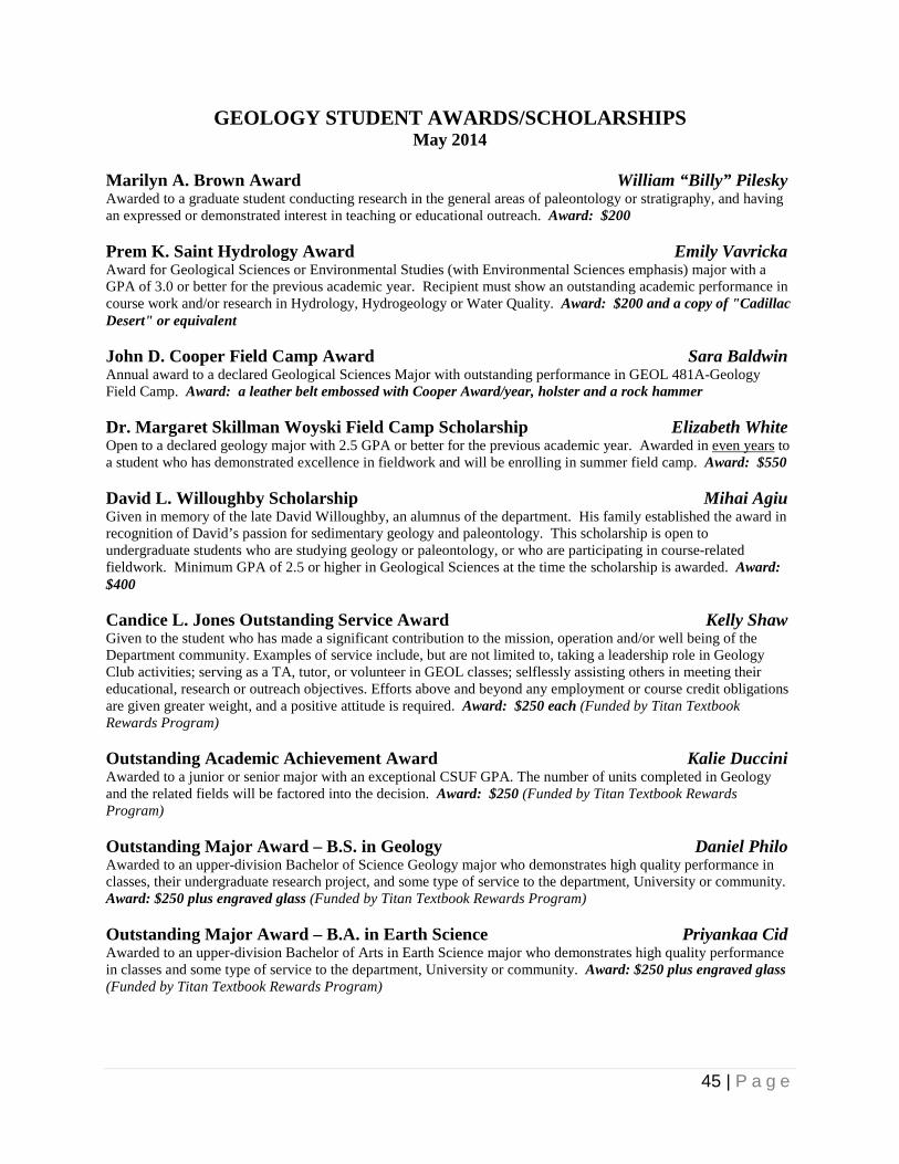
GEOLOGY STUDENT AWARDS/SCHOLARSHIPS May 2014
Marilyn A. Brown Award William “Billy” Pilesky Awarded to a graduate student conducting research in the general areas of paleontology or stratigraphy, and having an expressed or demonstrated interest in teaching or educational outreach. Award: $200 Prem K. Saint Hydrology Award Emily Vavricka Award for Geological Sciences or Environmental Studies (with Environmental Sciences emphasis) major with a GPA of 3.0 or better for the previous academic year. Recipient must show an outstanding academic performance in course work and/or research in Hydrology, Hydrogeology or Water Quality. Award: $200 and a copy of "Cadillac Desert" or equivalent John D. Cooper Field Camp Award Sara Baldwin Annual award to a declared Geological Sciences Major with outstanding performance in GEOL 481A-Geology Field Camp. Award: a leather belt embossed with Cooper Award/year, holster and a rock hammer Dr. Margaret Skillman Woyski Field Camp Scholarship Elizabeth White Open to a declared geology major with 2.5 GPA or better for the previous academic year. Awarded in even years to a student who has demonstrated excellence in fieldwork and will be enrolling in summer field camp. Award: $550 David L. Willoughby Scholarship Mihai Agiu Given in memory of the late David Willoughby, an alumnus of the department. His family established the award in recognition of David’s passion for sedimentary geology and paleontology. This scholarship is open to undergraduate students who are studying geology or paleontology, or who are participating in course-related fieldwork. Minimum GPA of 2.5 or higher in Geological Sciences at the time the scholarship is awarded. Award: $400 Candice L. Jones Outstanding Service Award Kelly Shaw Given to the student who has made a significant contribution to the mission, operation and/or well being of the Department community. Examples of service include, but are not limited to, taking a leadership role in Geology Club activities; serving as a TA, tutor, or volunteer in GEOL classes; selflessly assisting others in meeting their educational, research or outreach objectives. Efforts above and beyond any employment or course credit obligations are given greater weight, and a positive attitude is required. Award: $250 each (Funded by Titan Textbook Rewards Program) Outstanding Academic Achievement Award Kalie Duccini Awarded to a junior or senior major with an exceptional CSUF GPA. The number of units completed in Geology and the related fields will be factored into the decision. Award: $250 (Funded by Titan Textbook Rewards Program) Outstanding Major Award – B.S. in Geology Daniel Philo Awarded to an upper-division Bachelor of Science Geology major who demonstrates high quality performance in classes, their undergraduate research project, and some type of service to the department, University or community. Award: $250 plus engraved glass (Funded by Titan Textbook Rewards Program) Outstanding Major Award – B.A. in Earth Science Priyankaa Cid Awarded to an upper-division Bachelor of Arts in Earth Science major who demonstrates high quality performance in classes and some type of service to the department, University or community. Award: $250 plus engraved glass (Funded by Titan Textbook Rewards Program)

46 | P a g e
Donor Giving Page
$7,845.86
$20,472.09
$25,000.00
$1,415.57
$24,497.98
$7,931.49
$3,334.23 $2,690.30 $2,025.00 $970.75 $574.09 $346.54
$2,944.50
$0.00
$5,000.00
$10,000.00
$15,000.00
$20,000.00
$25,000.00
$30,000.00
$35,000.00
Department of Geological Sciences
Donor Giving Options

47 | P a g e
Thanks to All of Our Geology Students, Faculty and Staff for
another successful year within the Geology Family!!!

48 | P a g e
Geology Research Day 2014