2015-06-15 airport master plan final
TRANSCRIPT

Airport Master PlanHutchinson Municipal Airport –Butler Field (HCD)Hutchinson, Minnesota
July 2015
Submitted by:Bolton & Menk, Inc.12224 Nicollet AvenueBurnsville, MN 55337 P: 952-890-0509
Airport Sponsor:City of Hutchinson
1400 Adams Street SEHutchinson, MN 55350
P: 320-234-4219

Hutchinson Municipal Airport (HCD) – Airport Master Plan
TABLE OF CONTENTS i
TABLE OF CONTENTS TABLE OF CONTENTS ............................................................................................................................... i
LIST OF FIGURES ...................................................................................................................................... ii
LIST OF APPENDICES .............................................................................................................................. iii
EXECUTIVE SUMMARY ......................................................................................................................... iv
1. INTRODUCTION ........................................................................................................................ 1-1
1.1. PURPOSE ........................................................................................................................ 1-1
1.2. BACKGROUND ............................................................................................................. 1-1
1.3. AREAS OF EMPHASIS ................................................................................................. 1-1
1.4. STRUCTURE OF AN AIRPORT MASTER PLAN ....................................................... 1-2
1.5. PUBLIC & AGENCY OUTREACH ............................................................................... 1-2
2. AIRPORT INVENTORY ............................................................................................................. 2-1
2.1. LOCATION ..................................................................................................................... 2-1
2.2. HISTORY ........................................................................................................................ 2-1
2.3. SURROUNDING DEVELOPMENT .............................................................................. 2-2
2.4. SOCIOECONOMIC ........................................................................................................ 2-2
2.5. AIRPORT ROLE ............................................................................................................. 2-4
2.6. AIRPORT MANAGEMENT........................................................................................... 2-5
2.7. AVIATION ACTIVITY .................................................................................................. 2-5
2.8. AIRPORT DESIGN STANDARDS ................................................................................ 2-6
2.9. CLIMATE ........................................................................................................................ 2-9
2.10. AIRSIDE FACILITIES ................................................................................................. 2-10
2.11. LANDSIDE FACILITIES ............................................................................................. 2-14
2.12. LAND USE AND DEVELOPMENT ............................................................................ 2-16
2.13. ENVIRONMENTAL OVERVIEW ............................................................................... 2-20
3. AVIATION FORECASTS .......................................................................................................... 3-1
3.1. INTRODUCTION ........................................................................................................... 3-1
3.2. USER SURVEY SUMMARY ......................................................................................... 3-1
3.3. AVIATION TRENDS ..................................................................................................... 3-4
3.4. EXISTING BASED AIRCRAFT & ANNUAL OPERATIONS .................................... 3-6
3.5. BASED AIRCRAFT FORECAST .................................................................................. 3-7
3.6. ANNUAL OPERATIONS FORECAST ....................................................................... 3-10
3.7. FUTURE CRITICAL DESIGN AIRCRAFT ................................................................ 3-15
3.8. SUMMARY ................................................................................................................... 3-16

Hutchinson Municipal Airport (HCD) – Airport Master Plan
TABLE OF CONTENTS ii
4. FACILITY REQUIREMENTS .................................................................................................... 4-1
4.1. INTRODUCTION ........................................................................................................... 4-1
4.2. AIRFIELD CAPACITY & DEMAND ANALYSIS ....................................................... 4-2
4.3. INSTRUMENT APPROACHES ..................................................................................... 4-3
4.4. RUNWAY FACILITY REQUIREMENTS .................................................................... 4-4
4.5. AIRPORT VISUAL AIDS & NAVIGATIONAL AIDS .............................................. 4-11
4.6. METEOROLOGICAL FACILITIES ............................................................................ 4-12
4.7. TAXIWAY & TAXILANE FACILITY REQUIREMENTS ........................................ 4-12
4.8. APRON SIZE & TIE-DOWN REQUIREMENTS ........................................................ 4-13
4.9. MN SASP AIRSIDE RECOMMENDATIONS ............................................................ 4-14
4.10. LANDSIDE FACILITY REQUIREMENTS ................................................................ 4-14
4.11. MN SASP LANDSIDE RECOMMENDATIONS ........................................................ 4-18
4.12. SUMMARY ................................................................................................................... 4-18
5. FACILITY IMPLEMENTATION PLAN .................................................................................... 5-1
5.1. FUNDING INFORMATION........................................................................................... 5-1
5.2. PROJECT SCHEDULE ................................................................................................... 5-2
LIST OF FIGURES Figure 2-1 Airport Vicinity Map ....................................................................................................... 2-24
Figure 2-2 Airport Location Map ...................................................................................................... 2-25
Figure 2-3 Existing Airport Layout ................................................................................................... 2-26
Figure 2-4 2013 Pavement Condition Index (PCI) Rating ................................................................ 2-27
Figure 2-5 Existing Building Area ..................................................................................................... 2-28
Figure 2-6 State Airport Zoning & County Zoning Map ................................................................... 2-29
Figure 2-7 Natural Environment ........................................................................................................ 2-30
Figure 2-8 Built Environment & Compatible Land Use Considerations ........................................... 2-31
Figure 3-1 Service Area & Drive Time ............................................................................................. 3-17
Figure 4-1 Planning Considerations Map .......................................................................................... 4-19
Figure 4-2 Stopway Alternative ......................................................................................................... 4-20
Figure 4-3 Primary Runway Realignment ......................................................................................... 4-21
Figure 4-4 South Crosswind Runway Alternatives ........................................................................... 4-22
Figure 4-5 Central Crosswind Runway Alternatives ......................................................................... 4-23
Figure 4-6 North Crosswind Runway Alternatives ........................................................................... 4-24
Figure 4-7 Building Area for South Crosswind Runway Development ............................................ 4-25

Hutchinson Municipal Airport (HCD) – Airport Master Plan
TABLE OF CONTENTS iii
Figure 4-8 Building Area for North Crosswind Runway Development ............................................ 4-26
Figure 4-9 Future MnDOT Safety Zoning ......................................................................................... 4-27
Figure 5-1 Short-Term Projects (present – 5 years)........................................................................... 5-11
Figure 5-2 Mid-Term Projects (6-10 years) ....................................................................................... 5-12
Figure 5-3 Long-Term Projects (11-20 years) ................................................................................... 5-13
LIST OF APPENDICES
APPENDIX A USER SURVEY
APPENDIX B CAPITAL IMPROVEMENT PLAN (CIP)
APPENDIX C AIRPORT LAYOUT PLAN
APPENDIX D FAA GRANT ASSURANCES

Hutchinson Municipal Airport (HCD) – Airport Master Plan
EXECUTIVE SUMMARY iv
EXECUTIVE SUMMARY The Airport Master Plan for the Hutchinson Municipal Airport – Butler Field (HCD) evaluates the needs of the existing and future users of the airport over the next 20 years. The Airport Master Plan was last updated in 1976. Numerous elements have changed at the airport since that time and require the Airport Master Plan and Airport Layout Plan (ALP) to be updated. The changes include a runway extension, fuel facility installation, construction of the Arrival/Departure (A/D) building and Fixed Base Operator (FBO), construction of a parallel taxiway, T-hangars, and a large hangar. The existing building area plan in the ALP needs to be updated to address recent hangar construction and evaluate future development possibilities.
The Airport Master Plan is a joint effort between the Hutchinson Airport Commission, City of Hutchinson, the Federal Aviation Administration (FAA), and Minnesota Department of Transportation (MnDOT) Office of Aeronautics. An Airport Master Plan includes discussion of the existing inventory at the airport, the results of the user survey submitted to the service area around the airport, the forecasts of aircraft activity including based aircraft and operations, the facility recommendations to meet the forecasted needs of the users of the airport, alternatives of the recommended facilities, and the implementation plan.
The City of Hutchinson is located in south-central Minnesota, 20 miles west of the seven county metro area. It is part of McLeod County, and is 10 miles north of Highway 212. Minnesota State Highways 7, 15, and 22 are the main routes into the City. The airport is a general aviation facility serving primarily business owners, agricultural sprayers, and recreational pilots that use single-engine and multi-engine propeller driven aircraft in addition to some small business jets.
There are currently 42 based aircraft at the airport. There is an A/D building which includes a hangar for the FBO, four public T-hangars for based aircraft storage, one public conventional hangar, six private hangars, and 15 tie-downs available for aircraft parking. There is an automobile parking lot located near the A/D building and 100LL and Jet A fuel are available for aircraft.
The airport has one runway. Runway 15/33, is a bituminous runway 4,000 feet long by 75 feet wide. There is a Global Positioning System (GPS) with vertical guidance (LPV) approach to both runway ends, and a parallel taxiway which connects the runway to the building area.
The aviation forecasts show growth in based aircraft over the next 20 years to 54 aircraft in 2033, which represents a growth of 12 aircraft. The annual operations are estimated to be 12,180 growing to 15,660 over the next 20 years.
Based on the 20 year forecasts, facility recommendations were developed. According to the FAA Advisory Circular (AC) titled Runway Length Requirements for Airport Design, the existing runway length of 4,000 feet is sufficient for the 20-year planning period. The airport, however, does not meet the 95% wind coverage requirement. Alternatives were analyzed to realign the runway or to add a crosswind runway. The selected alternative adds a 2,500-foot long, 60-foot wide, turf crosswind runway to the north of the existing building area, which achieves 98.66% wind coverage. Other airside facility requirements include looking at adding stopways to each runway end.
Additional needs identified in the user survey and activity forecasts included additional hangar space for private hangar development, additional T-hangar space for the increase in based aircraft, and an expanded apron area to accommodate additional tie-down spaces for aircraft parking.
The final chapter of the Airport Master Plan takes a look at the timing and funding necessary to develop the facilities recommended to accommodate the existing and future users of the airport. Further discussion of the facility requirements, project impacts, and details of the forecast analysis for the Hutchinson Municipal Airport – Butler Field can be found within the Airport Master Plan document.

Hutchinson Municipal Airport (HCD) – Airport Master Plan
INTRODUCTION
Page 1-1
1. INTRODUCTION 1.1. PURPOSE An Airport Master Plan is a comprehensive study of an airport and describes the short (0-5 year), mid (5-10 year), and long-term (10-20 year) development plans to meet existing and future aviation demand based on identified airport safety, facility, and aviation system needs. The Airport Master Plan will provide direction and guidance to the airport owner, the City of Hutchinson, regarding future airport preservation and development priorities for the Hutchinson Municipal Airport (FAA identifier: HCD). It will become the City’s realistic strategy for the development of the airport considering financial, environmental, and socioeconomic factors. The Federal Aviation Administration (FAA) outlines the requirements and process to prepare an Airport Master Plan through Advisory Circular (AC) 150/5070-6B, Airport Master Plans.
1.2. BACKGROUND The City of Hutchinson last completed an update to the Airport Layout Plan (ALP) in June 2011. An Airport Master Plan was last completed in 1976. This Airport Master Plan will update operations and based aircraft projections so airport development plans can meet the needs of the public utilizing the airport while maintaining compatibility with community land use plans.
The existing ALP will need to be modified to depict the as-built airport development along with the future airport plans recommended in this Airport Master Plan update.
1.3. AREAS OF EMPHASIS An Airport Master Plan process evaluates many aspects of an airport facility. The following areas of emphasis have been specifically identified by the City of Hutchinson and will be reviewed in greater detail for HCD.
Runway Alternatives The current ALP shows an existing and future primary runway (Runway 15/33) length of 4,000 feet, in addition to a turf crosswind runway (Runway 8/26) at a length of 2,800 feet. The Airport Master Plan will evaluate existing and foreseeable airport users and the primary runway length and crosswind runway requirements to meet the needs at HCD. Runway development options will be explored considering local zoning implications, compatibility with community plans, operational effects, airspace obstructions, environmental impacts, and cost. In addition, the primary runway will be evaluated for the potential to reduce impacts to surrounding land owners.
Land Use Planning Runway development options will have an effect on surrounding local land use. The Airport Master Plan will evaluate runway options and coordinate with local planning staff to ensure that off-airport impacts are acceptable and follow community planning needs and airport zoning requirements.
Obstruction Analysis The Airport Master Plan will complete a comprehensive airspace obstruction analysis for any future airport configuration chosen through the Airport Master Plan process.

Hutchinson Municipal Airport (HCD) – Airport Master Plan
INTRODUCTION
Page 1-2
Public Involvement Engaging the community and stakeholders throughout the planning process is important for the airport to continue to gain support from the community and continue to serve their needs. A public involvement plan has been put in place to consider the broader interests of the general public.
1.4. STRUCTURE OF AN AIRPORT MASTER PLAN Existing airport inventory Environmental overview Aviation activity forecasts Capacity and demand analysis Facility requirements including alternative analysis Implementation plan
1.5. PUBLIC & AGENCY OUTREACH Outreach is an important aspect of the Airport Master Plan process to solicit input and foster support for the vision of the airport over the next 20 years. The Airport Master Plan is to be used as a guide for decision makers when evaluating existing and future needs of the airport and implementing improvements. Although more detailed justification and funding of individual projects are key components before any development can occur, the Airport Master Plan recognizes the “big picture” potential of the airport and puts an overall plan in place for the future.
There were three primary forms of outreach throughout the Airport Master Plan process.
Development of a Master Plan Advisory Group (MPAG) – this group met four times throughout the Airport Master Plan process to provide input on the issues, needs, and development for the airport over the next 20 years. The MPAG consisted of members from the Airport Commission, City of Hutchinson staff, McLeod County, Fixed Based Operator (FBO) staff, pilots at the airport, in addition to FAA and Minnesota Department of Transportation (MnDOT) Office of Aeronautics staff. Staff from the various organizations represented the interest of their areas of expertise.
Airport User Survey – A user survey was distributed to current and potential HCD users. The survey asked respondents how often they use the airport, why they use the airport, and what facilities, services, or airport improvements were needed to increase their use of the airport. This information was used to assist in developing the forecasts and facility requirements.
Public Open House – After the inventory, forecasts, and alternatives portions of the Airport Master Plan were developed in coordination with the MPAG, a public open house was held to inform the public of the Airport Master Plan process and the selected layout for the 20 year plan for the airport. Approximately five people from the public were in attendance. The open house included a forum for those in attendance to ask questions about the project or the airport in general.
In addition to these activities, project meetings were held with FAA and MnDOT Office of Aeronautics throughout the master planning process to ensure participation in and support of the 20 year plan at the airport. Meeting design standards and setting the framework for justification of projects in the future will help the City in receiving funding participation from these agencies as the airport develops.

Hutchinson Municipal Airport (HCD) – Airport Master Plan
AIRPORT INVENTORY
Page 2-1
2. AIRPORT INVENTORY The existing facilities and conditions at the airport provide the baseline for comparison to implement future safety and capacity airport improvements. Collection of both on-airport and off-airport background information is important so the development of future facilities can be accomplished in partnership with the surrounding community.
2.1. LOCATION The City of Hutchinson is located in south-central Minnesota, 20 miles west of the seven county metro area. It is part of McLeod County, and is 10 miles north of Highway 212. The City is located along the South Fork Crow River. Minnesota State Highways 7, 15, and 22 are the main routes into the City. Figure 2-1 at the end of this chapter, shows the regional location of Hutchinson.
Hutchinson Municipal Airport-Butler Field (FAA Identifier: HCD) is located two miles south of the Downtown Central Business District and is within City limits. The airport can be accessed via State Highway 15. Figure 2-2, at the end of this chapter, shows the local airport location.
Airport property consists of 288.11 acres, owned and operated by the City of Hutchinson. The airport owns an additional 59.02 acres in easement. Field elevation for the airport is 1,062 feet above mean sea level (MSL). The airport’s official location is defined by the Airport Reference Point (ARP), which marks the center area of the useable runways at the airport. The ARP for HCD is N 44°51’35.57” latitude and W 94°22’57.03” longitude.
2.2. HISTORY The Hutchinson Municipal Airport is a public use airport that was constructed in 1965. The airport consists of one primary paved north-south runway (Runway 15/33). Throughout the years the airport has taken on many airport improvement projects.
HCD’s early growth was aided by a few key people within the community. The first key person was Ken Butler, for whom the airport is named – Butler Field. Ken was instrumental in the development of Flying Farmers in the 1950s and promoted many farm airstrips. He was also vocal in the fight against the construction of tall towers that were hazardous to flight. In 2004 he was inducted into the Minnesota Aviation Hall of Fame.
The second prominent figure in the development and growth of the airport was Joe Dooley. Joe served on the Airport Commission for nearly three decades and was Commission Chair several times. Joe helped the airport grow and thrive, sometimes contributing his own money to help with airport expenses. The Arrival/Departure (A/D) building is named after him.
Some of the major milestones in the history of the airport’s development are documented below:
1965: Acquisition of land and construction of a landing strip
1967: Construction of an apron and taxilane
1970: The runway was paved and runway lighting was installed

Hutchinson Municipal Airport (HCD) – Airport Master Plan
AIRPORT INVENTORY
Page 2-2
1989: T-Hangar site prep; apron and taxiway improvements; land acquisition
1993: Runway extension and fuel facility construction
1999: A/D Building, Fixed Based Operator (FBO) facility, parallel taxiway, apron improvements, and entrance road were constructed
2001: Rotating beacon replaced
2005: Replaced REILs and installed jet fuel system
2007: T-hangar construction
2009: Large hangar constructed
2.3. SURROUNDING DEVELOPMENT The City of Hutchinson is located in an agricultural area with rolling hills in central Minnesota. Numerous lakes and wetlands make up the landscape as well.
HCD is predominately surrounded by agricultural land uses. A few residential properties are located near the airport, and there are commercial retail uses to the northeast. HCD is surrounded by County Road 7 to the west, State Highway 15 to the east, County Road 115 (Airport Rd SW) to the north and McCuen Creek to the south. The City of Hutchinson Comprehensive Plan identifies the areas surrounding the airport to be guided for continued public/institutional, agricultural, industrial, and commercial land uses. These land uses are compatible with airport operations. The area surrounding the airport is identified in the comprehensive plan as a joint planning district. This district was created in a cooperative effort between the City of Hutchinson and the surrounding townships to work together to effectively plan for the growth of the City of Hutchinson in a way that is sensitive to the needs of rural areas.
2.4. SOCIOECONOMIC Socioeconomic information provides background on area population, employment, and income. These measures indirectly identify trends in the airport service area which may contribute to changes in airport activity. Long-term, steady growth of population, employment, and personal income in the airport service area is generally an indication of a healthy local economy and increased aviation demands.
2.4.1. POPULATION The City of Hutchinson has seen an increasing population growth of 1.43% since 1970. This is a higher level of growth than County, State, and National figures for the same time period. Good location and economic opportunity have been identified as a major reason for development and increasing population. McLeod County has also seen strong population growth since 1970 averaging 0.71% over the 40 year period (See Table 2-1). Increasing population trends are expected to continue.
HCD Aerial Photo (1991)

Hutchinson Municipal Airport (HCD) – Airport Master Plan
AIRPORT INVENTORY
Page 2-3
Table 2-1 Local and Regional Existing and Forecasted Population
Year City of Hutchinson McLeod County
1970 8,031 27,662 1980 9,244 29,657 1990 11,523 32,030 2000 13,080 34,898 2010 14,178 36,651 2020 16,237 42,230 2030 17,325 44,660
Historical Trend (Yearly)
1.43%
0.71%
Forecast Trend (Yearly)
1.01%
0.99%
Source: U.S. Census Bureau, Minnesota State Demographic Center
2.4.2. EMPLOYMENT Employment is another socioeconomic measure of the vitality of a regional economy and demand for aviation. Significant employment industries in McLeod County include manufacturing, retail sale, construction, service industry, and educational services. The unemployment rate in McLeod County at the time of the 2010 Census was 4.1%, which was lower than the Minnesota rate of 5.0% and the United States average of 7.8%.
According to the City of Hutchinson Economic Development Authority, major employers within the community include the following:
Hutchinson Technology 3M Corporation Hutchinson Health Wal-Mart Hutchinson Schools ISD #423 Cash Wise Foods Menards Goebel Fixture Co. Target Shopko
City of Hutchinson Ag Systems, Inc. NU-Telecom JCPenny Hutchinson Manufacturing Hutchinson Utilities
Commission Haugen Furniture Company Impressions, Inc. Customer Elation
Ohly Crow River Press Hutchinson Leader Warrior Manufacturing Richard Larson Builders American Energy Systems CreekSide Soils Hillyard Floor Care – Supply 3-D CNC, Inc.

Hutchinson Municipal Airport (HCD) – Airport Master Plan
AIRPORT INVENTORY
Page 2-4
2.4.3. INCOME Income is another socioeconomic measurement tool which can provide assumptions about new businesses and development. Generally, the higher the income the more likely demand for aviation activities will increase.
Median household income for McLeod County, according to the 2010 U.S. Census Bureau is $55,275 which is lower than the state average of $58,476, and higher than the United States figure of $52,763. Minnesota has a per capita personal income of $30,310 compared to $27,915 in the United States. McLeod County, defined as the airport service area, has a per capita personal income of $27,644.
2.5. AIRPORT ROLE 2.5.1. FEDERAL NPIAS The National Plan of Integrated Airport Systems (NPIAS) is made up of 3,330 airports that are open for public use. These airports are considered significant to the national air transportation system and are eligible for Federal funding. Airports within the NPIAS are classified as commercial service (primary or non-primary), cargo service, reliever airports, or other general aviation airports.
HCD is classified by Federal Aviation Administration (FAA) as a general aviation airport. Over 2,900 airports are classified as general aviation airports nationwide. General aviation airports economically support local businesses, provide critical community access, allow for emergency response, and provide other specific aviation functions. In 2012, a study was completed by FAA in an effort to classify general aviation facilities titled General Aviation Airports: A National Asset. These airports have been broken down further by FAA as national, regional, local, basic or unclassified facilities within the NPIAS system. HCD is classified as a local general aviation airport. There are 1,236 local general aviation airports in the national system.
Local Airports are the backbone of our general aviation system with at least one local airport in virtually every state. They are typically located near larger population centers, but not necessarily in metropolitan or micropolitan areas. Local airports account for 42% of the general aviation airports eligible for Federal funding. They also account for approximately 38% of the total flying at the studied general aviation airports and 17% of flying with flight plans. Most of the flying is by piston aircraft in support of business and personal needs. In addition, these airports typically accommodate flight training, emergency services, and charter passenger service. The flying tends to be within a state or immediate region. There are no heliports, but there are four seaplane bases in this category.
2.5.2. STATE SYSTEM PLAN Each state is responsible for developing a more detailed system plan with development objectives. Minnesota Department of Transportation (MnDOT) Office of Aeronautics classifies airports as key airports, intermediate airports or landing strips. HCD is classified as an intermediate airport in the 2012 Minnesota State Aviation System Plan (SASP).
Intermediate Airport – These airports have paved and lighted primary runways that are less than 5,000 feet long. Intermediate airports can accommodate all single engine aircraft, some multi-engine aircraft, and some corporate jets. There are 83 intermediate airports in Minnesota.
The SASP identifies projected airport development facility needs for each airport based on its classification. The SASP has identified the following anticipated needs for HCD: an expanded apron, additional tie-downs, additional T-hangars, automobile parking, and perimeter fence construction. Facility requirements will be discussed in further detail in Chapter 4.0, Facility Requirements.

Hutchinson Municipal Airport (HCD) – Airport Master Plan
AIRPORT INVENTORY
Page 2-5
2.6. AIRPORT MANAGEMENT The Hutchinson Municipal Airport is owned and operated by the City of Hutchinson, the airport sponsor. The Public Works Manager is in charge of managing the airport. The City of Hutchinson provides airport maintenance and upkeep. The Hutchinson City Council, in consultation with the Airport Commission, makes decisions on the management, budgeting, operations, maintenance, and development needs at HCD. The Airport Commission consists of five members appointed by the Mayor/City Council who are residents of the City and one additional member who serves on the City Council.
2.7. AVIATION ACTIVITY Aviation activity provides a measurement of the number and type of based aircraft and operations at an airport facility. Existing airport operational data is important to provide baseline information to project future activity, which in turn identifies airport facility needs.
Data for non-towered general aviation airports tends to vary. The Airport Master Plan will attempt to provide realistic airport operational figures using an airport user survey and observations from the airport manager. The data below provides a general overview of airport activity at HCD based on existing published data.
2.7.1. BASED AIRCRAFT Based aircraft are aircraft that are stored at an airport for the majority of the year. They are typically classified by type of aircraft, including single and multi-engine piston aircraft, jet, and ultralight aircraft. Sources of historical and current based aircraft data include the FAA Terminal Area Forecast (TAF), Airport 5010 Master Record, SASP, as well as local verified records and counts. The FAA TAF does not break down the total number of based aircraft by aircraft type.
Table 2-2 shows current based aircraft estimates from existing sources. The number of based aircraft ranges from 35 to 46.
Table 2-2 Based Aircraft – Existing Sources
Source Single Engine
Multi-Engine Jets Other Total
FAA TAF (2011)* N/A N/A N/A N/A 39
FAA 5010 Report (2013) 34 1 0 0 35
SASP (2010) 38 3 0 5 46 MnDOT Registration Report (2013) 38 1 0 5 44
Local Count (2014) 39 1 0 2 42 Source: FAA, MnDOT Office of Aeronautics, City of Hutchinson; N/A = Not Available * FAA TAF is updated in 2013, however 2011 is the most recent non-projected data in the TAF
Based on field inventory conducted by the City of Hutchinson in 2014, the confirmed number of based aircraft at HCD is 42. Four of the 42 aircraft are currently classified as part-time aircraft. These aircraft base their aircraft at HCD, however at some point during the year, mostly during winter, the aircraft is based elsewhere. Two aircraft owners are on a waiting list to base their aircraft at HCD. According to the Airport Manager, the list could have as many as four to ten additional aircraft owners waiting to base aircraft at HCD if enclosed storage spaces were available. These numbers are based on phone calls asking

Hutchinson Municipal Airport (HCD) – Airport Master Plan
AIRPORT INVENTORY
Page 2-6
about hangar availability. The waiting list numbers will be used for determining the needs of the based aircraft users.
2.7.2. AIRCRAFT OPERATIONS An operation is classified as either a takeoff or a landing. Touch and go training operations count as two operations. Airport operations are typically split into local and itinerant operations. Local operations are defined in FAA’s Forecasting Activity by Airport as “aircraft operating in the traffic pattern or aircraft known to be departing or arriving from flight in local practice areas, or aircraft executing practice instrument approaches at the airport.” Itinerant operations are “aircraft operations other than local operations.” Aircraft operations are also categorized by the use of the aircraft operating at the airport. Examples of this include commercial, general aviation, and military operations. Sources of historical and current airport operational data include the FAA TAF, Airport 5010 Master Record, and the SASP.
Table 2-3 lists the current airport operations estimates from existing sources.
Table 2-3 Annual Operations – Existing Sources
Itinerant Operations Local Operations
Source Air Carrier Air Taxi General
Aviation Military General Aviation Military Total
FAA TAF (2011)* 0 0 5,645 0 6,750 0 12,395
FAA 5010 Report (2013) 0 200 5,400 45 6,750 0 12,395
SASP (2010) N/A N/A 5,466 N/A 6,683 0 12,149 Source: FAA, MnDOT Office of Aeronautics; N/A = Not Applicable * FAA TAF is updated in 2013, however 2011 is the most recent non-projected data in the TAF
The FAA TAF projects annual operations will stay stagnant through 2040 and the SASP forecasts a 1.6% annual growth rate through 2030.
2.8. AIRPORT DESIGN STANDARDS FAA airport design standards are based on two key components. The first component is the critical aircraft family currently using the airport or proposed to use the airport at least 250 times per year within the next five years. The second component is based on the type of approach developed for each runway end. Both the critical aircraft and the approach type are discussed in the next two sections to determine the design standards to be followed when planning future development at HCD.
2.8.1. CRITICAL DESIGN AIRCRAFT Airport Reference Code (ARC) Development of the existing and future facilities at an airport relies upon the identification of the most demanding aircraft type currently utilizing or projected to utilize the airport. FAA defines the critical aircraft as an aircraft or a family of aircraft that are expected to conduct at least 500 annual itinerant operations at the airport (one takeoff and one landing is considered two operations).
The Airport Reference Code (ARC) translates the operational and physical characteristics of the aircraft intended to operate at the airport to FAA airport design criteria used at the airport. The ARC is based on

Hutchinson Municipal Airport (HCD) – Airport Master Plan
AIRPORT INVENTORY
Page 2-7
three components. The first ARC component, depicted by a letter, is the Aircraft Approach Category (AAC) which correlates to aircraft approach speed (operational characteristics). The breakdown of each category can be seen in Table 2-4. The second and third components, depicted by a Roman numeral, are the Airplane Design Group (ADG) which relates to aircraft wingspan and tail height (physical characteristics). The physical characteristics for each group can be seen in Table 2-5.
Table 2-4 FAA Aircraft Approach Category (AAC)
Category Approach Speed (knots) Example Aircraft Type
A < 91 Cessna 172, Piper Warrior B 91 - < 121 Beech King Air, Cessna Citation I & II C 121 - < 141 Learjet 35, Gulfstream 550, B-737 D 141 - < 166 B-757, B-747, B-777
Source: FAA AC 150/5300-13A Airport Design
Table 2-5 FAA Airplane Design Group (ADG)
Group Wingspan (feet) Tail Height (feet) Example Aircraft Type
I < 49 < 20 Beech Baron 58, Cessna 172 II 49 - < 79 20 - < 30 Beech King Air, Cessna Citation Series III 79 - < 118 30 - < 45 B-737, DC-9, CRJ-900 IV 118 - < 171 45 - < 60 A-300, B-757, B-767 V 171 - < 197 60 - < 66 B-747, B-777 VI 197 - < 262 66 - < 80 Lockheed C-5A, A-380
Source: FAA AC 150/5300-13A Airport Design
According to FAA AC 150/5300-13A, Airport Design, the ARC does not restrict the type of aircraft that can safely use the airport; the ARC is for planning and design purposes only. The existing design standards at HCD follow ARC B-II standards.
Approach Reference Code (APRC) & Departure Reference Code (DPRC) An Approach Reference Code (APRC) system is used to determine the current operational capabilities of a runway and associated parallel taxiway with regard to landing operations. An APRC identifies the operational capabilities of a runway using the ARC (AAC and ADG) with planned runway approach visibility minimums to establish design standards. Visibility minimums are expressed in Runway Visual Range (RVR) values, in feet, as defined in Table 2-6.
The Departure Reference Code (DPRC) describes the current operational capabilities of a runway and associated parallel taxiway with regard to takeoff operations. It is similar to the APRC and is composed of the ARC, but does not include visibility minimums. In addition, a runway may have more than one DPRC designation.

Hutchinson Municipal Airport (HCD) – Airport Master Plan
AIRPORT INVENTORY
Page 2-8
Table 2-6 Runway Visual Range (RVR) values
RVR (feet) Approach Type Visibility Minimums
VIS Visual – no instrument approach Not applicable
5000 Non-Precision Approach or Approach with Vertical Guidance No lower than 1 mile
4000 Approach with Vertical Guidance Lower than 1 mile but not lower than ¾ mile 2400 Precision Approach (Category I) Lower than ¾ mile but not lower than ½ mile 1600 Precision Approach (Category II) Lower than ½ mile but not lower than ¼ mile 1200 Precision Approach (Category III) Lower than ¼ mile
Source: FAA AC 150/5300-13A Airport Design
The existing APRC for the Runway 15 end is B-II-4000, and B-II-5000 for the Runway 33 end. The DPRC for both runway ends is B-II. The design requirement categories for each runway end may change over time as design aircraft and approach types change at the airport.
Runway Design Code (RDC) The Runway Design Code (RDC) signifies the design standards to which the runway is to be built. The RDC is composed of the same three components as the APRC. However, the RDC is based on planned development for each runway and does not have any operational application for the current runway configuration. The RDC will be discussed in greater detail at the end of Chapter 3.0, Aviation Forecasts, to determine the runway design standards to be used for the critical aircraft proposed to use the airport over the next 20 years.
2.8.2. APPROACH TYPES Instrument approach procedures provide arriving pilots with guidance to the airport runway during periods of low visibility. FAA publishes instrument approach procedures defining the horizontal and vertical flight path to land at an airport. Flight visibility and cloud ceiling height minimums are established for each instrument approach procedure based on available navigational aids, airspace obstructions, aircraft equipment, and pilot certification. Visual approaches to a runway have no instrument approach procedure nor do they require additional aircraft or ground equipment. There are three types of instrument approaches:
Non-Precision Approach – A standard instrument approach procedure with horizontal guidance but no vertical descent guidance. Types of non-precision approaches include localizer, RNAV/GPS (area navigation/global positioning system), RNAV/RNP (area navigation/required navigation), NDB (non-directional beacon), and VOR/TVOR (very high frequency omni-directional range/terminal very high frequency omni-directional range). These type of approaches require additional equipment in the aircraft, but no additional ground-based equipment is needed.
Approach with Vertical Guidance – An instrument approach procedure providing electronic course and vertical descent guidance. Additional aircraft equipment is typically required. These approaches can utilize ground-based navigational aids such as a glide slope or can be accomplished with only a satellite based navigational aid such as a Localizer Performance with Vertical Guidance (LPV).
Precision Approach – An instrument approach procedure with both vertical descent guidance and horizontal guidance to the runway. These type of approaches utilize ground based equipment such as an Instrument Landing System (ILS).

Hutchinson Municipal Airport (HCD) – Airport Master Plan
AIRPORT INVENTORY
Page 2-9
Currently, Runway 15/33 has an RNAV (GPS)/LPV approach procedure to both runway ends. The Runway 15 approach has a visibility of ⅞ mile and the Runway 33 end has a visibility of one mile. In addition there is a VOR approach to the airport with 1 mile visibility minimums.
The nearest precision approach is available at the Wilmar Municipal Airport (BDH) located 35 miles northwest of HCD. The approach minimums are 200 foot cloud ceiling and ¾ mile visibility. This approach is a good alternative if weather conditions are below instrument approach minimums at HCD. According to weather data, this occurs 4.52% of the time.
2.9. CLIMATE Climate considerations for airport planning include wind, temperature, precipitation, cloud cover, and visibility. Minnesota experiences a humid continental climate characterized by large seasonal temperature differences. This climate experiences frigid winters and warm summers. Precipitation is generally distributed year-round.
Wind data is important as it helps define runway orientation at an airport. Aircraft are designed to take off and land into the wind. Crosswinds and tailwinds can create a hazardous situation for pilots, particularly those flying smaller aircraft.
The National Climatic Data Center in Ashville, North Carolina collects wind data through an Automated Weather Observation System (AWOS) at the airport. FAA recommends ten years of wind data be collected at the airport site or the closest airport site where data is available. HCD has an AWOS on site that collects wind data, see the photo on the right side of the page. The analysis below includes hourly wind direction and speed observations for the period from January 1, 2003 through December 31, 2012.
The existing wind coverage for the primary runway at HCD is summarized in Table 2-7. FAA recommends a primary runway orientation provide 95%wind coverage. When this is not achieved, a crosswind runway may be needed. The allowable crosswind component per RDC is 10.5 knots for RDC A-I; 13 knots for RDC A-II and B-II; 16 knots for RDC A-III, B-III, C-I through C-III, and D-I through D-III; and 20 knots for RDC A-IV and B-IV, C-IV through C-VI, D-IV through D-VI and E-I through E-VI. The allowable crosswind component at HCD is 13 knots for RDC B-II.
Table 2-7 All-Weather Wind Coverage
Runway Crosswind Component
10.5 knots 13.0 knots 15/33 91.19% 95.48%
Source: National Climatic Data Center for Hutchinson, MN (2003-2012)
The 95% wind coverage is achieved with B-II and A-II aircraft, but not for A-I/B-I or smaller aircraft that may use HCD. Since 95% wind coverage is not achieved for the 10.5 knot crosswind component, a crosswind runway may be needed at HCD. This will be further evaluated in Chapter 4.0, Facility Requirements.
Temperature is important in determining required runway length. Warm temperatures cause the air to become less dense, thus requiring aircraft to use more runway length for takeoff. Precipitation also causes

Hutchinson Municipal Airport (HCD) – Airport Master Plan
AIRPORT INVENTORY
Page 2-10
contamination of the runway leading to longer runway lengths being required. Cloud cover and visibility influence the need for navigational aids and approach procedures to runways.
The mean maximum temperature in the hottest month (July) from 1896 to 2012 is 83 degrees Fahrenheit. Average total annual precipitation is 29.3 inches, with a maximum of 4.7 inches in June. Average annual snowfall is 41.86 inches.
2.10. AIRSIDE FACILITIES The existing airside facilities are defined as the airport features that support aircraft operations. These include runways, taxiways, aprons, navigational aids, and visual aids. Figure 2-3, at the end of this chapter, depicts existing facilities at the airport.
2.10.1. RUNWAYS The primary runway at the airport, Runway 15/33, is 4,000 feet in length, 75 feet in width, and has a paved bituminous surface. Runway 15/33 is marked with non-precision runway markings delineating the centerline and each threshold. The runway is lit with Medium Intensity Runway Lights (MIRLs) for better visibility of the pavement edge during night operations or times of inclement weather. The runway is relatively flat with an effective gradient, (a measure of elevation change), of 0.2%. The published pavement strength is 12,500 pounds or less in a single-wheel landing gear configuration. A runway with this pavement strength is considered a utility runway. The runway is designed to B-II-4000 standards. This signifies the current operation capability of accommodating aircraft with approach speeds up to 121 knots, wingspans up to 79 feet, and runway approaches lower than one mile but not lower than ¾ mile. A picture of Runway 15/33 can be seen on the right side of this page.
Currently, the transverse grades between the runway and taxiway are too steep and have caused damage to aircraft that have veered off the runway. These issues will be addressed in Chapter 4.0, Facility Requirements.
2.10.2. AIRPORT VISUAL AIDS Airport visual aids are important features that provide airport visual references to pilots, especially during low visibility or night operations. The various visual aids available at HCD are summarized below:
Rotating Beacon: A rotating beacon identifies the location of an airport facility to pilots in the air. Most civilian general aviation airports alternate white and green lights from dusk until dawn, and during instrument flight rules (IFR) conditions. The rotating beacon is located west of Runway 15/33 near the wind cone (see Figure 2-3 at the end of the chapter). A picture of the rotating beacon is located on the right side of this page.
Hutchinson Municipal Airport (HCD) – Airport Master Plan
AIRPORT INVENTORY
Page 2-11
Runway Edge and Threshold Lighting: Runway edge and threshold lights are installed to outline the edges of runways in low-light and restricted visibility conditions. White/amber lights identify the runway edge, while red/green lights identify the runway threshold at each end. Runway lighting systems have three different intensity levels; low, medium, and high depending on the classification of the runway. HCD has medium intensity runway lighting (MIRL) installed along Runway 15/33. The lights are stake-mounted and are currently in fair condition.
Taxiway Edge Lighting/Marking: Taxiway edge lights or markers outline the edges of taxiways. Taxiway lights are blue and have low and medium intensity systems available. Retro-reflective markers, using reflective blue tape mounted on a pole, may be used in lieu of taxiway lighting as a low cost alternative. HCD has taxiway edge lighting installed along each of the five connecting taxiways. Retro-reflective markers are installed along parallel Taxiway A and can be seen in the picture on the right side of this page.
Runway Markings: Runway markings are installed for visual identification of a paved runway during all weather conditions. Markings vary in complexity based on the type of approach for a runway; visual, non-precision instrument, and precision instrument. Runway 15/33 has non-precision runway markings delineating the runway centerline and threshold. The runway markings are currently in good condition.
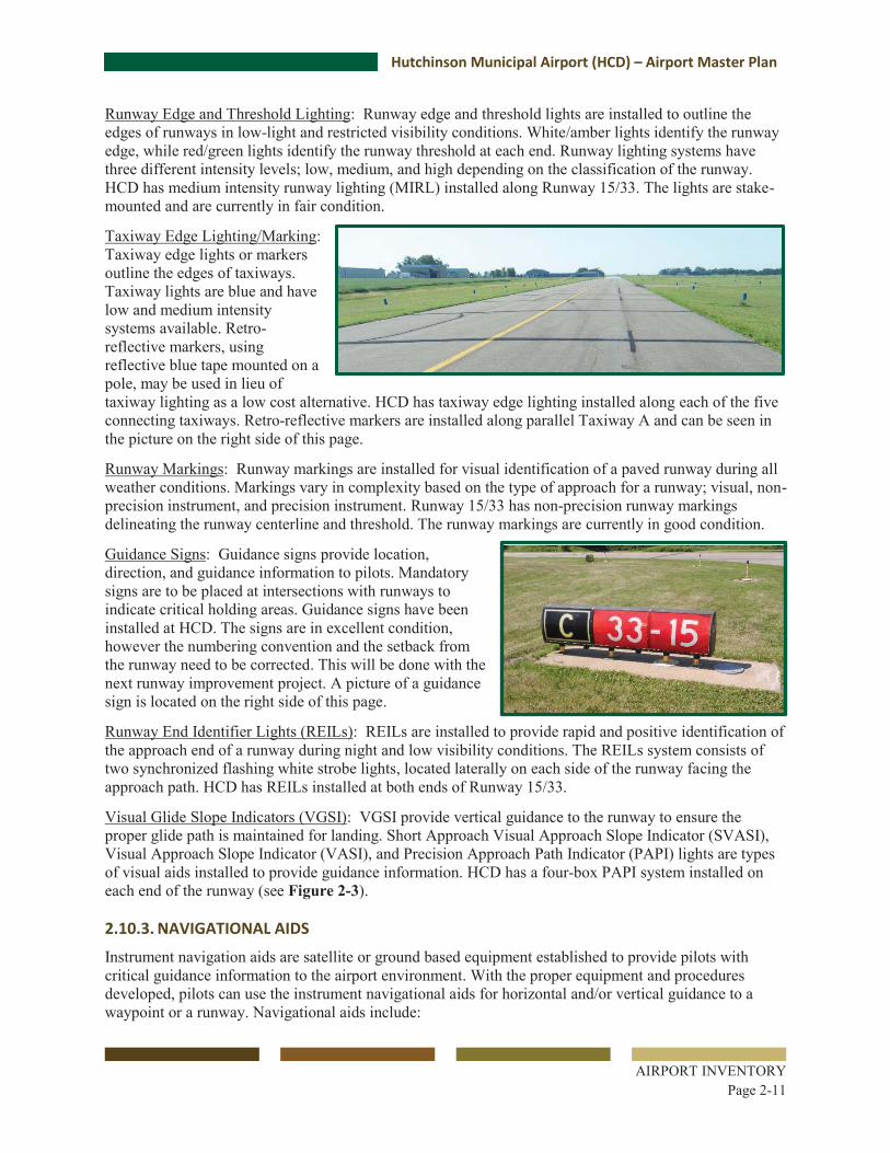
Guidance Signs: Guidance signs provide location, direction, and guidance information to pilots. Mandatory signs are to be placed at intersections with runways to indicate critical holding areas. Guidance signs have been installed at HCD. The signs are in excellent condition, however the numbering convention and the setback from the runway need to be corrected. This will be done with the next runway improvement project. A picture of a guidance sign is located on the right side of this page.
Runway End Identifier Lights (REILs): REILs are installed to provide rapid and positive identification of the approach end of a runway during night and low visibility conditions. The REILs system consists of two synchronized flashing white strobe lights, located laterally on each side of the runway facing the approach path. HCD has REILs installed at both ends of Runway 15/33.
Visual Glide Slope Indicators (VGSI): VGSI provide vertical guidance to the runway to ensure the proper glide path is maintained for landing. Short Approach Visual Approach Slope Indicator (SVASI), Visual Approach Slope Indicator (VASI), and Precision Approach Path Indicator (PAPI) lights are types of visual aids installed to provide guidance information. HCD has a four-box PAPI system installed on each end of the runway (see Figure 2-3).
2.10.3. NAVIGATIONAL AIDS Instrument navigation aids are satellite or ground based equipment established to provide pilots with critical guidance information to the airport environment. With the proper equipment and procedures developed, pilots can use the instrument navigational aids for horizontal and/or vertical guidance to a waypoint or a runway. Navigational aids include:

Hutchinson Municipal Airport (HCD) – Airport Master Plan
AIRPORT INVENTORY
Page 2-12
Very-high frequency Omni-directional Range (VOR): Ground-based facilities that provide distance and radial information used for non-precision en-route and terminal navigation. A VOR station is located near HCD in Darwin, Minnesota. This facility also has Distance Measuring Equipment (DME) to provide distance information to pilots. An approach procedure to HCD has been developed from this VOR/DME facility.
Instrument Landing System (ILS): Ground-based facilities (Localizer Antenna, Glide Slope Antenna, Approach Lighting System) that provide distance, horizontal, and vertical guidance information to runway ends where installed. The closest runway with an ILS is located at Willmar Municipal Airport (BDH), 35 nautical miles northwest of HCD.
Global Positioning System (GPS): Equipment and satellites that enable pilots to navigate to a waypoint without the need for primary ground-based equipment. GPS provides horizontal guidance, but can also provide vertical guidance for instrument approaches with published procedures. GPS with vertical guidance is called Localizer Performance with Vertical Guidance (LPV) procedures. There are straight-in GPS approach procedures to both runway ends at HCD.
Non-Directional Beacon (NDB): Ground-based facilities that provide horizontal directional guidance. The closest non-directional beacon (NDB) for pilot navigation is located in Glencoe, approximately 14 miles southeast of Hutchinson. NDBs are currently being decommissioned by FAA in lieu of GPS navigation.
2.10.4. METEOROLOGICAL FACILITIES Timely weather information is important to the safety of aircraft operations. Pilots can locally obtain weather information from the following sources:
Wind Cone: The wind cone is used to indicate wind direction at HCD. The wind cone is located west of Runway 15/33 towards the middle of the runway. The wind cone is visible to pilots from either runway end (see Figure 2-3). A picture of the wind cone can be seen on the right side of the page.
Automated Weather Observation System (AWOS): An AWOS measures critical meteorological data on-site at airports including wind speed, wind direction, temperature, dew point, cloud coverage and ceiling, visibility, precipitation, and barometric pressure. HCD has an AWOS facility west of Runway 15/33 (see Figure 2-3).
2.10.5. TAXIWAYS AND TAXILANES A taxiway system at an airport provides access to and from the runways, aircraft apron, and hangar facilities. Taxiways are constructed for safety purposes to expedite the flow of departing and arriving aircraft from the runway. A taxiway system consists of parallel taxiways and/or connecting taxiways.
Runway 15/33 has a full parallel taxiway (Taxiway A) with five (5) connector taxiways providing access to the main runway (see Figure 2-3). The existing parallel taxiway is 40 feet wide. The separation distance between the taxiway centerline and the runway centerline is 300 feet. There are Medium Intensity Taxiway Lights (MITL) located at the intersections of the taxiways and runway, with reflectors located along the remaining portions of the taxiway.
Taxilanes are used within the building area to provide access from the apron to the hangars. There are taxilanes on the north and south ends of the building area. They provide access to the T-hangars at HCD.

Hutchinson Municipal Airport (HCD) – Airport Master Plan
AIRPORT INVENTORY
Page 2-13
2.10.6. APRON The aircraft apron provides an area for aircraft parking, aircraft storage, aircraft movements, fueling operations, and access to the A/D building and other hangars. The existing apron is approximately 14,200 square yards and is located to the east of the primary runway (see Figure 2-5). The apron was reconstructed in 2000. There are 15 in-pavement tie-downs available for aircraft parking. A picture of the apron can be seen on the right side of the page.
2.10.7. PAVEMENT CONDITION In order to continue to receive federal funding, all airports must implement a pavement maintenance program for any pavement constructed or repaired with federal money. MnDOT helps airports with this grant assurance by having a research company prepare pavement evaluation reports. All airports within the state are evaluated on a three year cycle. An evaluation update was completed for HCD in 2013. The evaluation report identifies the Pavement Condition Index (PCI) for each pavement section at the airport. The rating is used to identify pavement improvement needs based on FAA AC 150/5380, Guidelines and Procedures for Maintenance of Airport Pavements, and American Society for Testing and Materials (ASTM) D5340. The pavement ratings are shown in Table 2-8.
Table 2-8 PCI Ratings
Rating PCI Rating Work Repair Levels
Excellent 86 – 100 Preventive Maintenance
Very Good 71 – 85 Good 56 – 70
Major Rehabilitation Fair 41 – 55 Poor 26 – 40
Reconstruction Very Poor 11 – 25 Failed 0 – 10
Source: Minnesota Airport System Pavement Evaluation 2013 Update for Hutchinson Municipal Airport
Periodic pavement rehabilitation projects have been completed at the airport in recent years. Table 2-9 summarizes the PCI rating for each major pavement section at HCD. These areas are graphically represented in Figure 2-4 at the end of this chapter.

Hutchinson Municipal Airport (HCD) – Airport Master Plan
AIRPORT INVENTORY
Page 2-14
Table 2-9 Pavement Condition
Pavement Area Last
Construction Date(s)
2013 PCI
Runway 15/33 1994 66 Apron 2000 70/87 Parallel Taxiway and Connector Taxiways 2010 60 - 79 Taxilane (North Hangar Area) 2000 75 Taxilane (South Hangar Area) 1990 - 2000 26 - 71
Source: HCD Pavement Evaluation Report (2013), MnDOT Aeronautics
The pavement at HCD ranges from poor to excellent condition. The areas in the poorest condition include the area surrounding one of the south T-hangars and the connecting taxiway closest to the apron. These areas require major rehabilitation and possibly reconstruction in the near-term.
2.11. LANDSIDE FACILITIES 2.11.1. ARRIVAL/DEPARTURE (A/D) BUILDING An A/D building is utilized at a general aviation airport to provide an area for local and transient pilots and passengers to transition to and from the aircraft operations area. The A/D building at HCD was constructed in 1999, see photo on the right side of the page. The facility is approximately 3,000 square feet in size. Facilities include restrooms, conference room, office, lounge space for local and transient pilots, and computer access for flight planning. The building is located in close proximity to the hangar and apron area (see Figure 2-5, at the end of this chapter, for a detailed layout of the building area).
2.11.2. AUTOMOBILE ACCESS & PARKING The primary airport access road is located off of State Highway 15. The access road is a bituminous surface. There is no controlled access to the airport.
The airport automobile parking lot is paved and has 45 automobile parking stalls in immediate proximity to the A/D building (see Figure 2-5). The parking lot is commonly used by airport business employees, visitors, and transient passengers. Airport tenants commonly park their vehicle adjacent to their aircraft storage hangar.

Hutchinson Municipal Airport (HCD) – Airport Master Plan
AIRPORT INVENTORY
Page 2-15
2.11.3. AIRCRAFT STORAGE Aircraft storage hangars provide indoor storage for aircraft and aircraft tie-downs provide outdoor storage. Hangar facilities at HCD were initially developed south of the apron. Subsequent hangar buildings have been constructed north of the A/D building and apron area. There are three 8-unit T-hangars and one 11-unit T-hangar with open sides at HCD in addition to six private hangars and one public hangar, see photo on the right side of the page. All enclosed storage spaces are full. There are some open-sided hangars that are available for rent. In addition to hangar/covered storage, there are 15 tie-downs available on the apron for outside storage (see Figure 2-5).
2.11.4. HELICOPTER PARKING Helicopter parking is located in the southwest corner of the apron (see Figure 2-5). Lifelink III used this area for parking its helicopter for 8 years. It remains an electrically powered helicopter parking area for helicopters arriving at HCD.
2.11.5. AIRPORT FUEL SYSTEM The City of Hutchinson owns and operates the airport fuel facility located on the apron next to the A/D building (see Figure 2-5, and the photo on the right side of the page). The facility includes one 10,000 gallon 100LL (100 low lead) above ground fuel tank. The fuel tank was found in good condition, refurbished, and moved to its current location in 1998. There is also a 12,000 gallon above ground Jet A fuel tank. Fuels are dispensed through fueling pumps. A credit card reader allows for 24-hour self-fueling operations.
2.11.6. FIXED BASE OPERATOR (FBO) & OTHER AIRPORT BUSINESSES A common airport tenant is an FBO. An FBO is a commercial business providing one or more aviation-related services to the general flying public. Examples of these services include aircraft maintenance, flight instruction, charter services, aircraft fueling, aircraft parking, and hangar storage. Other airport tenants may include aviation related businesses that provide more specialized aeronautical services. Hutchinson Aviation served as the FBO at the HCD until May 2014, when ASI Jet AG Division, LLC (ASI) took over. ASI provides aircraft maintenance and is a Thrush aircraft authorized service center. The FBO can be seen in the picture on the right side of the page.
There are currently four businesses that have seven agricultural spray airplanes on the airfield. There has been a trend in the agricultural industry to consider the cost/benefit option of using aerial spraying equipment instead of wheeled boom-type sprayers. Wheeled boom-type sprayers may cause unwanted soil compaction on farm fields. In addition, the increasing use of micro-nutrients and micro-pesticide applications reduces the overall amount of chemicals added onto the field. This reduces costs and allows

Hutchinson Municipal Airport (HCD) – Airport Master Plan
AIRPORT INVENTORY
Page 2-16
for a safer food supply. Many of these applications are done at a specific time during plant development, making aerial application a viable alternative. These developments support continued growth in agricultural spraying operations.
2.11.7. AIRPORT MAINTENANCE The City of Hutchinson is responsible for monitoring the condition of the airport, completing snow removal and also grass cutting activities. The FBO coordinates with City staff as needed for additional snow removal or grass mowing, building repairs, periodic minor pavement repairs, and overall maintenance of the airfield.
Airport maintenance equipment storage is located off-site in the City equipment buildings. The City owns dedicated airport snow removal equipment consisting of a tractor with plow and snow blower.
2.11.8. UTILITIES & DRAINAGE HCD is not connected to City sewer and water. Electrical and natural gas service is available at all buildings at the airport. Telephone and internet service is also available from local phone, cable, and satellite companies.
Culverts and swales divert water from the building area, runways, and taxiways to the natural discharge points of local wetlands for groundwater infiltration. No stormwater filtration basins are on-site.
2.11.9. FENCING & SECURITY Airport fencing is installed to deter or prevent unauthorized access by persons or vehicles onto airport property, as well as define outer airport property boundaries. Fencing is also installed for wildlife protection. The existing airport property is not fenced. Access from the parking lot to the airfield is uncontrolled.
2.11.10. AIRPORT PROPERTY Airport property consists of 288.11 acres, owned in fee title by the City of Hutchinson. Since the previous Airport Layout Plan, the City completed a land swap with McLeod County which exchanged 3.73 acres of the northeast portion of Parcel 3 for 4.48 acres of property south of Airport Road. The existing parcel boundaries can be seen within the Airport Layout Plan update completed as a part of this project.
The City has also acquired 59.36 acres in easement within the approaches of the primary runway to protect airport airspace and land use compatibility interests. This number differs from the previous Airport Layout Plan to take into consideration the fact that Parcel 9 (originally an easement) was later purchased in fee as part of Parcel 14. The acres for Parcel 9 were not counted in the total existing easement numbers to avoid duplication. See Figure 2-3 at the end of this chapter.
2.12. LAND USE AND DEVELOPMENT FAA and MnDOT Office of Aeronautics strongly recommend airport sponsors maintain airspace and land uses compatible with airport operations. Airport land use compatibility means planning and controlling land uses in and around airports to promote use and development that does not create restrictions to the airport, or hazards to persons or property on the ground and the flying public. Maintaining compatible land use is an FAA grant assurance and is driven by the design standards for the airport. Land uses should be controlled within the airport property, runway protection zones, approach areas, and the general vicinity of the airport.

Hutchinson Municipal Airport (HCD) – Airport Master Plan
AIRPORT INVENTORY
Page 2-17
Minnesota State Statue Chapter 360 requires owners of public airports to enact airport land use and airspace safety zoning standards. The Minnesota Airport Land Use Compatibility Manual published in 2006 provides additional resources on this topic.
2.12.1. LAND USE PLANS The County Comprehensive Plan was last updated in 1990. The Comprehensive Plan for the County should be updated to account for recent city development trends and likely projections. The plan acknowledges much of the development that occurs within the County’s jurisdiction is on the fringe of municipalities.
The County’s Zoning Districts are highlighted in Figure 2-6, at the end of this chapter. The County Zoning Ordinance identifies several platted subdivisions in the area surrounding HCD. The platted areas to the north of the airport are outside of Safety Zone A for the existing 4,000-foot runway. Chapter 4.0, Facility Requirements will address the location of the platted subdivisions in relation to the future airport configuration. The City is aware of the restrictions around the airport and has worked closely with airport staff to determine potential residential growth areas near the airport.
The City of Hutchinson Comprehensive Plan identifies property surrounding HCD as guided for future infrastructure improvements. Investment in local infrastructure suggests greater density land uses will be pursued. These land uses have the potential to be incompatible with airport operations. Areas immediately outside of Hutchinson City Limits are identified in the Comprehensive Plan as a ‘joint planning district’. This joint planning group must guide critical areas surrounding HCD for land uses compatible with airport operations. The airport must restrict land uses that would create obstructions or lead to a congregation of people in the runway approach. The City of Hutchinson and McLeod County Comprehensive Plans should be amended to acknowledge HCD is an essential public facility that serves an important public transportation role. The Comprehensive Plan should guide land uses surrounding the airport to protect the flying public and people and property on the ground.
A residential neighborhood is located immediately east of the airport, outside of City limits. In addition, the areas to the northwest of the airport are currently zoned as Medium Density Residential and Single Family Residential. The growth in this area will need to be monitored and the Airport Zoning Ordinance needs to be enforced to avoid impacts to the existing and future plan for the airport (see Figure 2-6).
2.12.2. CONDITIONAL USE PERMIT The airport is classified by the City of Hutchinson as a Conditional Use within these areas. The airport lies entirely within City limits and prior to any airport construction project, a conditional use permit must be applied for with the City Planning Commission. The City Planning Commission will review the application and make a recommendation to the City Council for approval.
2.12.3. RUNWAY PROTECTION ZONE & MNDOT CLEAR ZONE FAA has established land use standards in the form of a Runway Protection Zone (RPZ). An RPZ area is designed to enhance protection of persons and property on the ground in the vicinity of the runway. An RPZ has a trapezoidal shape centered along the runway centerline and begins 200 feet beyond the end of each runway end at HCD. FAA prefers the RPZ be clear of structures, roads or other obstructions, and purchased in fee whenever practicable. RPZ dimensions are based on the runway design code and approach types established for each runway end.
According to FAA, land uses prohibited in the RPZ include buildings, residences, and places of public assembly (i.e. churches, schools, hospitals, office buildings, shopping centers, and other uses with similar concentrations of persons). FAA published interim guidance about land uses within RPZs in 2012. If the

Hutchinson Municipal Airport (HCD) – Airport Master Plan
AIRPORT INVENTORY
Page 2-18
RPZ dimensions or locations change, or if there is a local development proposal through the RPZ, FAA expects the RPZ to be clear of the following land uses:
Building and structures Recreational land uses Transportation facilities (including public roads/highways, vehicular parking facilities) Fuel storage facilities Hazardous material storage Wastewater treatment facilities Above ground utility infrastructure
If clearing the RPZ of the above mentioned land uses is not economically feasible or no proposed alternative is reasonable to other surrounding entities such as County or State officials, coordination with FAA is required. An alternatives analysis must be performed to avoid the new land use, minimize its impact within the RPZ, or mitigate risk to people and property on the ground.
There is a separate approach RPZ and departure RPZ for the Runway 15 end due to approach minimums for B-II aircraft being less than 1 mile. The starting point of each RPZ is the same, however the dimensions for the RPZs are different (see Figure 2-3). Table 2-11 lists the dimensions of the RPZs for each runway end at HCD.
MnDOT Office of Aeronautics has developed Clear Zone (CZ) standards which are adopted as part of department policy. These dimensions vary from the RPZ areas defined by FAA (see Figure 2-3). MnDOT Office of Aeronautics requires the CZ to be acquired in fee to continue to receive airport development funding. Similar to the RPZ, dimensions for the CZs are defined by runway classification, instrument approach type, and instrument approach minimums. Table 2-11 lists the existing MnDOT Office of Aeronautics CZ dimensions at HCD.
Table 2-11 FAA RPZ & MnDOT CZ Dimensions
Runway RPZ Dimensions (Inner width x length x outer width)
Clear Zone Dimensions (Inner width x length x outer width)
15 Existing Approach RPZ: 1,000’ x 1,700’ x 1,510’ Departure RPZ: 500’ x 1,000’ x 700’ 500’ x 1,000’ x 800’
33 Existing 500’ x 1,000’ x 700’ 500’ x 1,000’ x 800’ Source: FAA AC/150 5300-13A Airport Design; MnDOT Office of Aeronautics, Planning & Zoning (2007)
The City of Hutchinson owns airport property that covers the majority of the RPZs. Avigation easements are in place over other critical areas for Runway 15/33 to protect critical airspace (see Figure 2-3). A portion of the Runway 15 approach RPZ is not owned in fee by the City. RPZ’s at the airport are free from any incompatible land uses. This Airport Master Plan will evaluate future runway configurations and any potential incompatibilities or necessary land acquisitions that may be necessary as a result of planned airport expansion.
2.12.4. STATE AIRPORT ZONING The State of Minnesota under Minnesota Statute Chapter 360 requires public airports to enact an overlay airport zoning ordinance to:

Hutchinson Municipal Airport (HCD) – Airport Master Plan
AIRPORT INVENTORY
Page 2-19
Protect the airport from incompatible land uses that could interfere with the safe operation of the airport.
Protect public safety by reducing the potential for fatalities, property damage, or noise complaints within the vicinity of the airport.
Protect the public investment made by taxpayers in the airport and maintain the economic benefits it provides to the region.
MnDOT airport zoning land use restrictions are defined below:
Safety Zone A extends outward from the end of the primary surface on the extended runway centerline a distance equal to two-thirds of the runway length or planned runway length. This zone does not allow buildings, temporary structures, uses that create wildlife hazards, or similar land use structural hazards; and should be restricted from uses that would create, attract, or bring together an assembly of people. Typical allowed land uses in Zone A include agriculture, cemetery, and automobile parking.
Safety Zone B extends farther outward from Safety Zone A, a distance equal to one-third the runway length or the planned runway length. This safety zone allows buildings on sites that encompass three or more acres; actual allowable building site area depends on the size of the parcel. Zone B should not create, attract, or bring together an assembly of people that would exceed 15 times the size of the parcel. Zone B cannot have more than one building plot area on which numerous structures can be constructed.
Safety Zone C encompasses all of the land enclosed within the perimeter of the FAA horizontal surface that is not included in Safety Zone A or Safety Zone B. Zone C shall not contain land uses that create or cause interference with the operation of radio or electronic communications between the airport and aircraft, make it difficult for pilots to distinguish between airport lights and other lights, result in glare, impair visibility of the airport vicinity, or endanger aircraft operations.
A multi-jurisdictional Hutchinson Municipal Airport Zoning Ordinance was adopted in 1984 by the Hutchinson Municipal Airport Zoning Board consisting of representatives from the City of Hutchinson, McLeod County, and Hassan Valley and Lynn Townships, pursuant to the provisions and authority of Minnesota Statutes 360.063. The Airport Zoning Ordinance was enacted to protect for the future airport configuration to meet minimum State standards. The Joint Airport Zoning Board in 1984 planned for an 800-foot runway extension to the north for a total runway length of 4,000 feet which has since been constructed. Therefore, the Zoning Ordinance protects for the existing runway configuration and conforms to the MnDOT model Airport Zoning Ordinance. The Airport Zoning Ordinance does not protect for the crosswind runway identified in the 2008 ALP. An update to the Airport Zoning Ordinance may be necessary to protect for the future runway configuration. The future runway configuration will be addressed in Chapter 4.0, Facility Requirements. The multi-jurisdictional zoning ordinance is administered by the City of Hutchinson and McLeod County. Figure 2-6, at the end of this chapter, shows both the existing airport zoning and underlying zoning at HCD.
2.12.5. COMMERICAL THROUGH-THE-FENCE In 1994 Skydive Hutchinson began operations at HCD. There were approximately 1,500 dives in June and July of 1994. A through-the-fence agreement was reached in August 1994, and in September the taxiway to the Skydive Hutchinson property was completed. Operations and the through-the-fence agreement ended in 2005, and no skydiving operations have been seen in the last five years. The taxiway and the property still remain, however the taxiway has not been maintained. The property is currently for sale, and the taxiway connector to the property will be removed with the next runway project.

Hutchinson Municipal Airport (HCD) – Airport Master Plan
AIRPORT INVENTORY
Page 2-20
2.13. ENVIRONMENTAL OVERVIEW The purpose of this section is to provide a general overview of environmental features which should be considered in the alternatives analysis. The intent is not to perform detailed analysis, but rather to assemble readily available information in a systematic manner. More comprehensive environmental analysis would be performed during the National Environmental Policy Act (NEPA) process to be discussed in the Implementation section of this Master Plan. Figure 2-7 and Figure 2-8, at the end of this chapter, depict important environmental considerations in and around HCD.
2.13.1. AIR QUALITY CLASSIFICATION The Clean Air Act (CAA) established National Ambient Air Quality Standards (NAAQS) for six pollutants (particulate matter, ground-level ozone, carbon monoxide, sulfur oxides, nitrogen oxides, and lead) termed “criteria pollutants.” There are no non-attainment areas in McLeod County. General conformity regulations do not apply to a Federal action in an area that is designated attainment for all six criteria pollutants.
2.13.2. AQUATIC CONCERNS Airport Drainage General drainage patterns for the airport are depicted on Figure 2-7. Drainage from the runway, taxiway, infield, and hangar areas is generally routed west to a north-south ditch along the westerly border of the airport. This ditch drains south to McCuen Creek approximately 1,000 feet south of Runway 33. McCuen Creek drainage runs east approximately 3.5 miles discharging to South Fork Crow River. Most of the airport stormwater conveyance is overland flow, with culverts and conveyance piping under taxiway and runway pavements where needed. Drainage from the east side of the hangar areas generally runs over land east to the State Highway 15 ditch.
Rivers The closest river to the airport is the South Fork Crow River, approximately two miles to the east. As described above, most airport drainage goes to McCuen Creek, which flows east ultimately to the South Fork Crow River. The South Fork Crow River in this reach has been categorized as Impaired by the Minnesota Pollution Control Agency (MPCA) for mercury and turbidity. This status elevates treatment requirements for drainage originating within a mile of the river. Since the airport is more than a mile from South Fork Crow River, these requirements do not apply. McCuen Creek is not designated as Impaired by the MPCA.
Wetlands The Clean Water Act affords protection for wetlands by the U.S. Army Corps of Engineers (USACE) under Section 404 and by the McLeod County Soil and Water Conservation District as the local administrator of the Minnesota Wetland Conservation Act (WCA). The Minnesota Pollution Control Agency provides water quality review and certification related to USACE permitting under Section 401 of the Clean Water Act. Projects that result in wetland impacts are required to demonstrate wetland impact avoidance and minimization in a permit application. The WCA and federal Clean Water Act have an established sequencing process for avoidance and minimization of impacts. Wetland impacts that cannot be feasibly avoided or minimized must be replaced by compensatory mitigation.
The National Wetland Inventory (NWI) wetlands on and in the vicinity of the airport property are depicted on Figure 2-7. It can be seen that three wetland areas are identified on or directly adjacent to the airport:
• West of the middle-southern portion of Runway 15/33

Hutchinson Municipal Airport (HCD) – Airport Master Plan
AIRPORT INVENTORY
Page 2-21
• At and east of Runway 15 • Directly east-northeast of the southerly hangar area
The nature of this mapping relative to existing airport conditions identifies the NWI information is dated. A runway extension project in the early 1990’s resulted in approximately eight acres of encroachment into the north wetland. Consistent with applicable regulatory requirements, this impact was mitigated by enhancing the wetland area west of Runway 15/33. The NWI identifies a wetland near the building area as can be seen on Figure 2-7. A wetland evaluation was conducted prior to building area development completed in 1999 and found no evidence of wetland resources in the area. Potential mitigation for future airport projects will need to consider the proximity to the airport as it relates to wildlife attractants.
Floodplains Floodplains are defined in Executive Order 11988, Floodplain Management, as:
“…the lowland and relatively flat areas adjoining inland and coastal waters including flood prone areas of offshore islands; including, at a minimum, that area subject to a one percent or greater chance of flooding in any given year.”
This definition refers to any area that would be inundated with floodwaters from a 100-year flood.
To meet Executive Order 11988, federally approved actions must avoid the floodplain, if a practicable alternative exists. If no practicable alternative exists, actions in a floodplain must be designed to minimize adverse impact to the floodplain’s natural and beneficial values. The design must also minimize the potential risks for flood-related property loss and impacts on human safety, health, and welfare.
HCD is not in or in proximity to Federal Emergency Management Agency (FEMA) floodplain areas.
2.13.3. TERRESTRIAL CONCERNS Soils Soils on and adjacent to the airport are in the “B” or “B/D” categories in the US Department of Agriculture’s hydrologic classification system. “A” soils have the highest infiltration rates, and “D” soils have the lowest. “B/D” soils have the lowest infiltration rates unless they are drained through tiling or other measures. It can be assumed that any poor soils under and directly adjacent to runways and taxiways were corrected during construction activities.
Prime and Unique Farmlands The Farmland Protection Act (FPPA) of 1984 (7 USC 4201-4209) as amended, creates the statutory framework for considering important farmlands in Federal actions including federally-funded airport improvements. Using the Farmland Conversion Impact Rating Form (AD-1006), coordination with the local office of the Natural Resource Conservation Service (NRCS) is required to determine if farmland impacts are significant.
It can be seen on Figure 2-8 there are significant areas of Prime Farmland and Farmland of Statewide Importance on and in the vicinity of the airport. Given the airport is within city limits and relatively close to urban development, it is not anticipated the AD-1006 rating of airport projects will affect implementation of projects. However, this is a factor to consider when planning future projects.
Contaminated Areas Federal, State, and local laws regulate hazardous materials use, storage, transport, or disposal. These laws may extend liability to past and future landowners of properties containing these materials. In addition, disrupting sites containing hazardous materials or contaminants may cause significant impacts to soil, surface water, groundwater, air quality, and the organisms using these resources.

Hutchinson Municipal Airport (HCD) – Airport Master Plan
AIRPORT INVENTORY
Page 2-22
A search of the Minnesota Pollution Control Agency database did not identify any contaminated sites on or in proximity to the airport. Information is provided that underground fuel tanks have been removed from the site and one 10,000 gallon aboveground storage tank remains. Based on the inventory at the airport, there are two above ground storage tanks at the airport. One is used for 100LL fuel and one is used for Jet A fuel. The MPCA report identifies there have been no compliance or enforcement actions associated with fuel tanks at the airport.
Habitat-Endangered/Threatened Species Based on US Fish and Wildlife Service (USFWS) information, there is only one federally listed Threatened, Endangered, Proposed, or Candidate species in McLeod County. That is the Poweshiek Skipperling (Oarisma poweshiek), which is a Candidate Species. Candidate species are plants and animals for which the USFWS has sufficient information on their biological status and threats to propose them as endangered or threatened under the Endangered Species Act. The Poweshiek Skipperling is a small moth-like butterfly. Its habitat is native prairie. Future airport projects would not impact areas of native prairie, and therefore would not be anticipated to impact this species.
2.13.4. CULTURAL RESOURCES Residential, Parks, and other Potentially Noise Sensitive Areas There is a rural residential structure approximately 580 feet southeast of the edge of the Runway 33 parallel taxiway (see Figure 2-8 at the end of this chapter). This structure is just outside of the Runway 33 RPZ. There is also a group of approximately 20 rural residential homes along State Highway 15 ranging from approximately 700 to 800 feet east of airport operating surfaces.
There are six parks within approximately one mile of the airport (all distances are from the edge of Runway 15):
• Elks Park, approximately 1.1 mile east-northeast • Linden Park, approximately 1.1 mile north-northeast • Junior Community Women Park, approximately 1.1 mile north-northwest • VFW Park, approximately 1.1 mile northeast • Lion’s Park West, approximately 1.2 mile north-northeast • Legion Park, approximately 1.3 mile northeast
There are four schools within approximately one mile of the airport (all distances are from the edge of Runway 15):
• Ridgewater Community College, 0.9 mile northeast • Hutchinson Middle School, 1.0 mile north-northwest • Hutchinson West Elementary School, 1.1 mile northwest • Hutchinson Senior High School, 1.3 mile north-northwest
There are six churches within approximately one mile of the airport (all distances are from the edge of Runway 15):
• Christ the King Lutheran, 0.9 north • Oak Heights Covenant Church, 1.0 mile north-northwest • River of Hope Lutheran Church & Vineyard United Methodist, 1.0 mile north • Word of Life, 1.1 mile northwest • Bethlehem United Methodist, 1.3 mile north-northeast • Church of God, 1.3 mile northeast
A snowmobile trail is located near the airport that traverses through airport property and Zone A of the Airport Zoning Ordinance (see Figure 2-8). The snowmobile trail is part of a 158 mile Crow River

Hutchinson Municipal Airport (HCD) – Airport Master Plan
AIRPORT INVENTORY
Page 2-23
Snowmobile Trail sponsored by the Department of Natural Resources (DNR) Grant in Aid (GIA) program. The DNR GIA program guidance documents requires snowmobile clubs or sponsors to receive permission for snowmobile trails to be located on public or private property.
MnDOT Office of Aeronautics has published an “Airport Land Use Compatibility Manual”; the manual suggests the use ‘may or may not be compatible’ with airport operations depending upon if there is a feasible alternative, if the use would lead to a congregation of people in the approach, and if the trail would be considered a structure or require appurtenances such as lighting. Federal Grant Assurances state FAA approval is required to use airport property for non-aeronautical land uses. The City of Hutchinson is working with the snowmobile trail operators to determine the best snowmobile trail route.
Historic and Archaeological The State Historic Preservation Office (SHPO) database of known historic and archeological sites was queried in November 2013 for any known cultural resources within one mile of the airport. The SHPO database contains no known cultural resources within this search area.
This review is only preliminary. As part of future NEPA review for specific projects advanced on the basis of this Airport Master Plan, more detailed historic and archeological review including site review and field sampling may be required. However, there are no known historic or archeological resources that would factor into the review of project alternatives in this Airport Master Plan.
Wildlife Areas The closest Wildlife Management Area (WMA) to the airport is the Hutchinson WMA. It is approximately 2.5 miles northwest of Runway 15. It is directly west of Campbell Lake, and approximately one third of a mile north of County Road 7 just outside the city limits. WMAs are part of Minnesota’s outdoor recreation system and are established to protect those lands and waters that have a high potential for wildlife production, public hunting, trapping, fishing, and other compatible recreational uses. They are owned by the State and managed by the Minnesota Department of Natural Resources (DNR). The Hutchinson WMA is approximately 49 acres in size. It contains grassland and wetland habitat at the north end of Campbell Marsh. It is closed to the hunting and trapping of all species.
General Land Use Concerns - Roadways The most significant land use constraints regarding the potential lengthening of Runway 15/33 are roadways at both ends of the runway. At the north end, Airport Road (County Highway 115) was realigned at the time of the runway extension project in the early 1990s to allow FAA RPZ and MnDOT Office of Aeronautics CZ requirements existing at that time to be met. Any lengthening of the runway at the north end would require an RPZ study and, likely, further roadway realignment. At the south end, State Highway 15 is already approximately 80 feet within the RPZ and 150 feet within the CZ. As with the north end, any lengthening of Runway 33 would require an RPZ study and, ultimately may require a roadway realignment.

Map Document: H:\Hutc\T51105897\Esri\GISTEST1_5\T51105897\Esri\Maps_Data\Master_Plan_Figures\105897 Fig1 Vicinity 85x11.mxdDate Saved: 1/20/2014 9:36:09 AM
_̂+¢
)w
!"̀$
!"̀$
)y
%&f(
%&e(
%&h(
!"b$
)n
PINETODD
MORRISONMILLELACS
KANABEC
DOUGLAS
BENTON
STEARNS
POPE
ISANTI
CHISAGO
SHERBURNE
SWIFT
KANDIYOHI
WRIGHT
ANOKAMEEKER
WASHINGTONHENNEPIN
CHIPPEWARAMSEY
MCLEOD CARVER
DAKOTARENVILLE SCOTT
SIBLEY
REDWOODGOODHUELE SUEUR
RICE
BROWN
NICOLLET
BLUEEARTH
COTTONWOOD WASECASTEELE
DODGEWATONWAN
LakeLillian
HeidelbergLe Sueur
Carlos
Litchfield
SilverLake
Brownton
EagleLake
Wabasso
GreenIsle
Melrose
HowardLake
Monticello
Mankato
Waseca
MeireGrove
Ogilvie
Milaca
Hutchinson
Cokato
Wanda
Rice
SaintAugusta
Atwater
Northfield
SaintClair
Kasota
LakeCrystal
Prinsburg
Morton
New Ulm
Morristown
Montgomery
Bowlus
Stewart
Glencoe
ClearLake
Foley
Kimball
Le Center
ChisagoCity
Holdingford
Sanborn
Swanville
LongPrairie
SpicerOtsego
NorthMankato
LesterPrairie
NewLondon
Butterfield
Darfur
Rockford
Gaylord
Claremont
SaintCloud
LittleFalls
Raymond
Flensburg
Pierz
Bock
SaintCloud
Clements
ColdSpring
Fairfax
RushCity
SaukCentre
Big Lake
Dundas
Blomkest
Elrosa
Zimmerman
Lamberton
Owatonna
Buffalo
Forada
Le Sueur
Sunburg
Swanville
Hillman
Westport
CedarMills
Cobden
SaintStephen
Princeton
SaintPeter
SaintAnthony
Jeffers
Courtland
PineCity
MountainLake
Hanover
Regal
Medford
Pemberton
Dennison
ElkRiver
Kerkhoven
Browerville
WestConcord
Watkins
SaintMichael
Foreston
NewPrague
Nelson
Royalton
NewAuburn
SaintJames
Glenwood
Cosmos
Gibbon
CannonFalls
Cambridge
MadisonLake
SaintMartin
SaintCloud
Upsala
Henriette
Randall
Evan
Waverly
Lastrup
SaintRosa
Franklin
Albertville
Hanska
SpringHill
RedwoodFalls
Madelia
Arlington
Elmdale
Annandale
Alexandria
RockCreek
SaukRapids
MankatoSpringfield
Grasston
Braham
Delano
Cleveland
Hinckley
Greenwald
Rockville
Olivia
Lafayette
Mora
Faribault
Royalton
Clearwater
Osakis
Comfrey
Quamba
Plato
GroveCity
WestUnion
Becker
Lindstrom
Dassel
SouthHaven
VernonCenter
Gilman
Montrose
Kenyon
SaintJoseph
Paynesville
Albany
Burtrum
Clearwater
Stacy
NorthBranch
Pennock
Onamia
Roscoe
GoodThunder
Morgan
SaintFrancis
Sartell
Isanti
Kingston
NewMunich
Kilkenny
Richmond
BrookPark
BuffaloLake
Villard
Danube
MapleLake
Genola
Willmar
Avon
Skyline
LakeHenry
Delhi
Sobieski
Brooten
Dayton
Biscay
Winthrop
BirdIsland
Lonsdale
Henderson
Darwin
Kandiyohi
Nerstrand
Freeport
La Salle
Princeton
Renville
Belgrade
Janesville
Hector
Wyoming
GreyEagle
Miltona
Elysian
Nicollet
Pease
Elysian
Sedan
Winsted
EdenValley
SleepyEye
Harris
Sartell
Buckman
Waterville
WaitePark
Hutchinson Municipal Airport
Airport Master Plan Airport Vicinity Map
Figure 2-1
_̂
Legend I
Source: MnDNR, MnDOT, McLeod County
_̂ Location
Interstate Highway
Other Principal Arterial
Municipal Boundary
Seven County Metro Area
McLeod County0 15
Miles

Map Document: C:\Users\christopherga\Desktop\AVIA_Transfers\HUTC\ESRI\Maps\Master_Plan_Figures\105897 Fig2 Location 85x11.mxdDate Saved: 6/25/2014 5:12:29 PM
_̂
McCuen Creek
?²A@
Runway 15/33 4,000' x 75'
Hutchinson
Existing Airport Property
SOUTH GRADE RD SW
FREEMONT AVE SE
ECHO
DR
SE
8TH AVESW
EAU CLAIRE AVE SE
ATLANTAAVESW
EDMONTON AVE SE
JEFFERSONST
SE
CLEVELAND AVE SW
AIRPORT ROAD
CENTURY AVE SW
SUNS
ET S
T SW
MER
RILL
S TSW8TH AVE SW
HASSANST
SE
DALE
STSW
CENTURY AVE SE
SHER
WOO
DST
SE
CHUR
CH S
T SW
HWY
15
SERVICE RD
HARR
ING T
ONST
SW
CRAIGAVESW
ELK DRSE
EDMONTON AVE SW
DETROITAVE
SE
HONE
YTRE
ERD
SW
MA R
K ET
STSW
DENVER AVE SW
SOUT
H SC
HOOL
RD
SWCo
unty
Rd. 7
Rd.
HIGH
WAY
15 S
LYN N
RDS W
DENVER AVE SE
SCHO
OLRD
SW
SHER
WOO
DST
SE
JO RGE NSONST SE
BLUEJAY
DR SW
BRAD
FORD
STSE
MON
T RE A
LST
SE
OTTAWA AVE
Sü
Hutchinson Municipal Airport
Airport Master Plan Airport Location Map
Figure 2-2
Legend I
Source: MnDNR, MnDOT, McLeod County
_̂ Location
Hutchinson Boundary
Airport Property0 1,500
Feet

Map
Doc
umen
t: C
:\Use
rs\c
hris
toph
erga
\Des
ktop
\AVI
A_T
rans
fers
\HU
TC\E
SRI\M
aps\
Mas
ter_
Plan
_Fig
ures
\105
897
Fig3
Exi
stin
g La
yout
11x
17.m
xdD
ate
Sav
ed: 3
/11/
2015
8:5
4:20
AM
?²A@
Run
way
15/
33 4
,000
' x 7
5'
? ,:: !:: :
$
Airp
ort B
eaco
n
$
Aut
omat
ed W
eath
erO
bser
vatio
n Sy
stem
(AW
OS)
$
Segm
ente
d C
ircle
&Li
ghte
d W
ind
Con
e
$
Run
way
End
Iden
tifie
rLi
ghts
(REI
L)
$R
unw
ay E
nd Id
entif
ier
Ligh
ts (R
EIL)
$
Con
nect
ing
Taxi
way
$
Para
llel T
axiw
ay
$
Prec
isio
n A
ppro
ach
Path
Indi
cato
r Lig
hts
(PA
PI)
$
Prec
isio
n A
ppro
ach
Path
Indi
cato
r Lig
hts
(PA
PI)
$
Med
ium
Inte
nsity
Run
way
Edge
Lig
htin
g (M
IRL)
$
Priv
ate
Han
gar
<:::
<:::
<: :
:
<: :
:
Exis
ting
Ease
men
tEx
istin
g Ea
sem
ent
Coun
tyRd
. 7
AIRPORT ROAD
Property
Property
Prop
erty
Pro
per
ty
Pro
per
ty
Property
Hut
chin
son
Mun
icip
al A
irpor
tA
irpor
t Mas
ter P
lan
Figu
re 2
-3
Exis
ting
Airp
ort L
ayou
t
Lege
nd
I
Sou
rce:
City
of H
utch
inso
n, E
SR
I Im
ager
y, M
cLeo
d C
ount
y
070
0 Feet
Ease
men
ts
Airp
ort P
rope
rty
Hut
chin
son
City
Lim
its
MnD
OT
Cle
ar Z
one
(CZ)
FAA
Run
way
Pro
tect
ion
Zone
(RP
Z)

Map
Doc
umen
t: C
:\Use
rs\c
hris
toph
erga
\Des
ktop
\AVI
A_T
rans
fers
\HU
TC\E
SRI\M
aps\
Mas
ter_
Plan
_Fig
ures
\105
897
Fig4
PC
I 11x
17.m
xdD
ate
Sav
ed: 4
/7/2
015
11:0
0:25
AM
?²A@
15
33
Run
way
15/
33 4
,000
' x 7
5'
AIR
POR
T R
OA
D
Pro
pert
y
Pro
pert
y
Prop
erty
Prop
erty
Prop
erty
Pro
pert
y
Hut
chin
son
Mun
icip
al A
irpor
tA
irpor
t Mas
ter P
lan
Figu
re 2
-420
13 P
avem
ent C
ondi
tion
Inde
x (P
CI)
Rat
ing
Lege
nd
I
Sou
rce:
City
of H
utch
inso
n, E
SR
I Im
ager
y, M
cLeo
d C
ount
y030
0 Feet
Airp
ort P
rope
rty
Pave
men
t Rat
ing
Exc
elle
nt
Very
Goo
d
Goo
d
Fair
Poo
r
Very
Poo
r
Faile
d

Map
Doc
umen
t: C
:\Use
rs\c
hris
toph
erga
\Des
ktop
\AVI
A_T
rans
fers
\HU
TC\E
SRI\M
aps\
Mas
ter_
Plan
_Fig
ures
\105
897
Fig5
Exi
stin
g B
uild
ing
Area
11x
17.m
xdD
ate
Sav
ed: 4
/7/2
015
11:2
1:09
AM
$
Arr
ival
/Dep
artu
re B
uild
ing $
Fuel
Fac
ility
(100
LL)
$
FBO
Han
gar
$
Aut
omob
ile P
arki
ng $
Util
ities
Bui
ldin
g
$
Civ
il A
ir P
atro
l
$
8-U
nit T
-Han
gar
$
8-U
nit T
-Han
gar
$
11-U
nit C
over
ed S
tora
ge
$
Hel
icop
ter P
arki
ng A
rea
$
Airc
raft
Apr
on&
Tie
-Dow
ns
$
Larg
e A
ircra
ft (G
reat
er T
han
12,5
00 p
ound
s) T
ie-D
own
$
Fuel
Fac
ility
(Jet
A)
Priv
ate
Han
gar A
rea
$
Con
nect
ing
Taxi
way
CTo
Be
Rem
oved
$
Bui
ldin
g R
emov
ed
Run
way
15/
33 4
,000
' x 7
5'
$
Airp
ort A
cces
s R
oad
$
8-U
nit T
-Han
gar
Prop
erty
Prop
erty
Property
Hut
chin
son
Mun
icip
al A
irpor
tA
irpor
t Mas
ter P
lan
Figu
re 2
-5
Exis
ting
Bui
ldin
g A
rea
Lege
nd
I
Sou
rce:
City
of H
utch
inso
n, E
SR
I Im
ager
y, M
cLeo
d C
ount
y
015
0 Feet
Airp
ort P
rope
rty

Map
Doc
umen
t: C
:\Use
rs\c
hris
toph
erga
\Des
ktop
\AVI
A_T
rans
fers
\HU
TC\E
SRI\M
aps\
Mas
ter_
Plan
_Fig
ures
\105
897
Fig7
Zon
ing1
1x17
.mxd
Dat
e S
aved
: 3/1
1/20
15 1
0:22
:16
AM
?²A@
15
33
HUTC
HINS
ON
Run
way
15/
33 4
,000
' x 7
5'
Coun
ty R
d. 7
Zon
e B
Zone B
Zon
e A
Zone A
Prop
erty
Prop
erty
Pro
per
ty
Zon
e C
Zone C
Zone
C
Zon
e C
Zone C
Zone
C
Hut
chin
son
Mun
icip
al A
irpor
tA
irpor
t Mas
ter P
lan
Figu
re 2
-6St
ate
Airp
ort Z
onin
g &
Cou
nty
Zoni
ng M
ap
Lege
nd
I
Sou
rce:
City
of H
utch
inso
n, E
SR
I Im
ager
y, M
cLeo
d C
ount
y01,
400 Fe
et
Run
way
Cen
terli
ne
Prim
ary
Sur
face
Airp
ort P
rope
rty
Hut
chin
son
City
Lim
its
MnD
OT
Min
imum
Saf
ety
Zone
sZo
ne A
Zone
B
Zone
C
Zoni
ng Frin
ge C
omm
erci
al
Auto
mot
ive
Ser
vice
Com
mer
cial
Indu
stria
l/Com
mer
cial
Hea
vy In
dust
ry
Ligh
t Ind
ustri
al P
ark
Man
ufac
ture
d H
ome
Par
k
Hig
h D
ensi
ty R
esid
entia
l
Med
ium
Den
sity
Res
iden
tial
Sing
le fa
mily
Res
iden
tial
Mix
ed U
se D
istri
ct
Agric
ultu
ral

Map Document: C:\Users\christopherga\Desktop\AVIA_Transfers\HUTC\ESRI\Maps\Master_Plan_Figures\105897 Fig9 Natural Environ 85x11.mxdDate Saved: 4/7/2015 11:19:39 AM
?²A@
Runway 15/33 4,000' x 75'
Hutchinson
McCuen Creek
a
aaa
a
a
aa
a
a
a
aa
aa
aa
a
a
aa
aa
a
a
SOUTH GRADE RD SW
FREEMONT AVE SE
EC
HO
DR
SE
BALTIMORE AVESW
EAU CLAIRE AVE SE
ATLANTAAVESW
SU
NS
ET
ST
SW M
ER
RIL
LS
TS
W
JEFFER
SON
ST
SE
CLEVELAND AVE SW
AIRPORTRO
AD
CENTURY AVE SW
DALE
STSW
NEAL AVE SW
8THAVE SW LYNDALEAVESW
SELCHOW
AVESE
ECHO CIRSE
SUMMERSET LN SE
CENTURY AVE SE
WINNIPEG AVE SE
LAURA AVE SW
EDMONTON AVE SE
CH
UR
CH
ST
SW
HA
RR
ING
TON
ST
SW
HW
Y15
SERVICE RD
CRAIG AVE SW
OTTAWA AVE SE
ELK DR SE
EDMONTON AVE SW
DETROIT AVE SE
HO
NE
YT
RE
E R
D S
W
MA
RK
ET
ST
SW
DENVER AVE SW
SO
UTH
SC
HO
OL
RD
SW
ADAMSST SE
York Rd.
160th St.
Cou
nty
Rd.
7S
CH
OO
L R
D S
W
HIG
HW
AY 1
5 S
LYN
N R
D S
W
DENVER AVE SE
SH
ER
WO
OD
ST
SE
J OR
GE
NS
ON
STSE
BLUEJAY
DR SW
BR
AD
FOR
DS
TS
E
KE
ITH
ST
SW
MO
NTR
EA
LS
TS
E
ORCHARDAVESE
Hutchinson Municipal Airport
Airport Master Plan Natural Environment
Figure 2-7
Legend I
Source: MnDNR, MnDOT, McLeod County
Hutchinson Boundary
Airport Property
FAA Runway Protection Zone (RPZ)
MnDOT Clear Zone (CZ)
Streams
Impaired Streams
NWI Wetlands
100-Year Floodplain
` Airport Drainage0 1,500Feet

Map
Doc
umen
t: C
:\Use
rs\c
hris
toph
erga
\Des
ktop
\AVI
A_T
rans
fers
\HU
TC\E
SRI\M
aps\
Mas
ter_
Plan
_Fig
ures
\105
897
Fig1
0 Bu
ilt E
nviro
n11x
17.m
xdD
ate
Sav
ed: 4
/7/2
015
11:2
3:33
AM
nm
nm
nm
nm
ï
î
î î
î
î
î
î î
î
î
î
?²A@
15
33
HUTC
HINS
ON
$
Res
iden
tial D
evel
opm
ent
Resid
entia
l Dev
elop
men
t
Run
way
15/
33 4
,000
' x 7
5'
Zon
e B
Zone B
Zon
e A
Zone A
Prop
erty
Prop
erty
Pro
per
ty
Rot
ary
Park M
iller
Woo
ds P
ark
Wom
ens
Clu
b Pa
rk
Rol
ling
Mea
dow
sEa
st P
ark
Sout
hPa
rk
Lion
sW
est
Park
JC S
outh
Park
Am
eric
anLe
gion
Park
Lind
enPa
rk
VFW
Par
kEl
ksPa
rk
Nor
thPa
rk
Mas
onic
Wes
tR
iver
Par
k (
Ove
rnig
ht C
amp)
AFS
Par
k
JC R
iver
side
Park
Drif
trid
ers
Park
Odd
fello
ws
Park
Rob
erts
Park
Zone
C
Zo
neC
ZoneC
Zon
eC
Zone
C
Hut
chin
son
Mun
icip
al A
irpor
tA
irpor
t Mas
ter P
lan
Figu
re 2
-8B
uilt
Envi
ronm
ent &
Com
patib
leLa
nd U
se C
onsi
dera
tions
Lege
nd
I
Sou
rce:
City
of H
utch
inso
n, E
SR
I Im
ager
y, M
cLeo
d C
ount
y
01,
400 Fe
et
Hut
chin
son
City
Lim
its
Airp
ort P
rope
rty
Run
way
Cen
terli
ne
Par
ks
NW
I
ïC
emet
ery
Exi
stin
g S
now
mob
ile T
rail
îC
hurc
h
nmS
choo
ls
MnD
OT
Min
imum
Saf
ety
Zone
sZo
ne A
Zone
B
Zone
C
Soils
All
area
s ar
e pr
ime
farm
land
Farm
land
of s
tate
wid
e im
porta
nce
Not
prim
e fa
rmla
nd
Prim
e fa
rmla
nd if
dra
ined

Hutchinson Municipal Airport (HCD) – Airport Master Plan
AVIATION FORECASTS Page 3-1
3. AVIATION FORECASTS 3.1. INTRODUCTION Evaluation of current and forecasted aviation activity is vital in preparing an Airport Master Plan. Aviation forecasts are necessary to evaluate current and potential future airport facility safety and capacity requirements.
Aviation forecasts are based on numerous factors including socioeconomic data, local, regional, and national aviation trends, and Federal Aviation Administration (FAA) aviation forecasting methodology. Guidance used to help develop aviation activity forecasts includes the following resources:
Forecasting Aviation Activity by Airport (July 2001), GRA, Inc., prepared for FAA.
Model for Estimating General Aviation Operations at Non-Towered Airports Using Towered and Non-Towered Airport Data (July 2001), GRA, Inc., prepared for FAA.
Forecasts for general aviation airports commonly include based aircraft, annual operations, and critical aircraft projections over a 20-year planning period. The time period for the forecasts at HCD are from the base year, 2013, through 2033. Based aircraft counts are split by the following aircraft types: single-engine piston, multi-engine piston, turboprop, turbojet, helicopter, and ultralight/experimental aircraft. Annual operations are classified as local or itinerant. Forecasting Aviation Activity by Airport defines local operations as “aircraft operating in the traffic pattern or aircraft known to be departing or arriving from flight in local practice areas, or aircraft executing practice instrument approaches at the airport.” Itinerant operations are defined as operations “other than local operations.” Critical aircraft projections are used to determine the airport design standards.
Forecasts developed are unconstrained; they identify the actual aviation demand for the facility regardless of limiting factors such as hangar availability or runway length, etc.
3.2. USER SURVEY SUMMARY To assist in determining the number of local aviation operations at HCD, and to help determine local aviation needs and trends, an airport user survey was conducted. A questionnaire was sent to users or potential recreational and business users of the airport facility. A copy of the airport user survey is located in Appendix A.
The service area for HCD covers the area half way between the airport and the surrounding airports with similar facilities. Since one advantage to flying is reduced travel time, it is assumed pilots will use the airport closest to their residence that has the facilities to meet their needs. The service area for HCD includes the western half of McLeod County and small portions of the eastern parts of Kandiyohi and Sibley Counties, as well as a small part in the south of Meeker County. User Surveys were sent to registered pilots within the service area in addition to registered pilots within the 30 minute drive time of the airport (see Figure 3-1 at the end of this chapter).
The survey at HCD was completed in November 2013. Of the nearly 300 questionnaires sent out, there were a total of 43 questionnaires returned (14%), 41 of which indicated an existing or future use of the airport. A summary of the operations reported in the survey are shown in Table 3-1.

Hutchinson Municipal Airport (HCD) – Airport Master Plan
AVIATION FORECASTS Page 3-2
Table 3-1 User Survey (2013) Annual Operations
Year Aircraft Annual Operations 2007 53 2,847 2012 53 2,641 2017 53 1,743
Source: HCD Airport User Survey (2013) Notes: Some survey respondents own more than one aircraft
Overall, airport users indicated a negative growth in annual aircraft operations at HCD. The sample size of the user survey was determined to be too low to make definitive conclusions on growth trends at HCD.
Of the 43 surveys that were returned, 53 aircraft were reported, of which 15 are based at HCD. This represents more than a one-third of the 42 based aircraft at HCD. Another 16 aircraft were reported as being based at airports within 30 nautical miles of HCD. In total 31 of the 53 aircraft reported are based in and around HCD.
Most of the reported aircraft were small aircraft and owned by the respondents. Four aircraft were corporate aircraft, with 12 of the 43 returned user surveys declaring use of their aircraft for business travel. Flight training was reported by 15 surveys as a major use of HCD. Ten users expressed interest in upgrading their aircraft fleet within five years, six of which were for performance improvements such as range, speed, and payload of aircraft.
The survey asked respondents two questions regarding their priorities and needs when using HCD. Table 3-2 and Table 3-3 indicate the user responses.
Table 3-2 Survey Question 10: Please Indicate the Types of Facilities Important to Your Use of HCD
Questions High Priority
Moderate Priority
Low Priority
Runway longer than 4,000 feet 5 17 21 Aircraft storage - T-hanger rental unit 6 15 22 Aircraft storage - Conventional hangar development site 6 14 23
Aircraft storage - Transient/overnight 9 15 19 Ground transportation (shuttle, taxi service, rental cars, courtesy car) 15 19 9
Fueling truck 4 9 30 Business center/meeting facilities 0 7 36
Source: HCD Airport User Survey (2013)

Hutchinson Municipal Airport (HCD) – Airport Master Plan
AVIATION FORECASTS Page 3-3
Table 3-3 Survey Question 11: What Services Do You Strongly Desire to Operate at HCD?
Services Desired Reponses Self-service fueling* 39 Full-service fueling 4 Aircraft charter 0 Transient Aircraft Storage* 9 Aircraft repair/maintenance* 27 Rental car 12 Crew rest area* 16 Conference room facilities 5 Flight training/instruction* 21 Pilot shop 8 Catering 0
Source: HCD Airport User Survey (2013) *Services are available at HCD
Additional comments included: need a crosswind runway (4 comments), fuel prices are too high compared to surrounding airports (4 comments), drainage ditches are a safety problem (3 comments), better snow removal (2 comments), longer runway (2 comments), need more T-hangar space, would like to see an opportunity for private hangar development, multiple dedicated corporate jet parking spaces.
A summary from the websites of each of the businesses are listed below:
Vessco, Inc.
o Vessco, Inc. is a supplier of water and wastewater technologies operating out of the main office in Chanhassen, MN. They “represent the best equipment” available for water treatment, and guide municipalities through the entire process from initial consultation to field service and parts delivery. Vessco, Inc. operates a Beechcraft Baron 58 about 20 times a year into HCD. They are looking to upgrade to a Beechcraft King Air that will maintain their current operations into HCD.
Life Flight
o An Air Medical service provider for Minnesota, Life Flight can transport those in need of immediate medical service anywhere in the world. Life Flight is capable of operating to Hutchinson in their Lear Jet aircraft.
ASI Jet, AG Division, LLC
o Starting as the new FBO in May 2014, ASI Jet is an authorized Thrush Aircraft service center. They currently operate three Thrush Aircraft for use in aerial application. Many Thrush and other agricultural aircraft visit ASI Jet for aircraft service as ASI Jet is one of three certified Thrush aircraft service locations in North America. The growth of aerial application in the Hutchinson area prompted their locating at HCD, and the amount of agricultural aircraft operations are expected to increase due to the lower cost of using agricultural aircraft compared to ground based application.

Hutchinson Municipal Airport (HCD) – Airport Master Plan
AVIATION FORECASTS Page 3-4
Form-A-Feed
o Form-A-Feed is a manufacturer of brand name and private label livestock feed. In business for over 40 years out of Stewart, MN, it has created or acquired companies to meet market needs. Form-A-Feed has numerous manufacturing and storage facilities across Minnesota, Iowa, and Nebraska. They frequently fly in and out of HCD.
United Farmers Cooperative (UFC)
o Starting in 1915 as the Creamery Cooperative Association of Lafayette, MN with two employees and sales of $35,000, the company has evolved over the last 85 years to have a presence in 11 communities, employ more than 200 Minnesotans, and have an annual sales volume of over $230 million.
Bobcat
o Bobcat is a manufacturer and provider of compact vehicles for construction, agriculture, and mining, in addition to other markets. Many companies in the region are involved with supplying parts to Bobcat.
o Another Bobcat full-service facility, and an authorized Bobcat dealer is Farm-Rite Equipment in nearby Dassell, MN. Beginning as a farm implement dealer in the 1970s, it is now exclusively a Bobcat Equipment dealer. They recently moved to a larger facility in Dassell in 2007.
3.3. AVIATION TRENDS 3.3.1. NATIONAL, REGIONAL & STATE TRENDS During the time period between 2001 and 2005, general aviation aircraft registered with FAA declined nearly 3.1%. From 2005 through 2011, the total number of general aviation aircraft remained relatively flat. The economic decline since 2008 has resulted in a reduction in the number of general aviation aircraft with FAA estimating the overall general aviation fleet being reduced by 2.7% from 2008 to 2011. Piston-powered fixed-wing aircraft, which make up the majority of general aviation aircraft, are projected to decrease in numbers through 2032 at a -0.1% average annual growth rate. The number of hours flown is projected to decrease by the same rate.
Shipments of new general aviation aircraft, according to the 2012 General Aviation Manufacturers Association (GAMA) year-end shipment report, have increased 0.6% from 2011 to 2012. This represents a slight upturn in manufacturing after years of decline since 2008. Total shipments in 2012 are down 50%, however, from 2007. Manufacturing of turboprop aircraft are up 10.6% in the same time period.
The outlook in the general aviation industry is favorable, especially in the areas of turbine aircraft, rotorcraft, and experimental aircraft. Overall activity levels are expected to grow.
According to the FAA Aerospace Forecast (2012-2032):
“The forecast calls for robust growth in the long term outlook, driven by higher corporate profits and the growth of worldwide Gross Domestic Product [GDP]. Additionally, continued concerns about safety, security, and flight delays keep business aviation attractive relative to commercial air travel. As the industry experts report a significant portion of piston aircraft hours are also used for business purposes, we predict business usage of general aviation aircraft will expand at a faster pace than that for personal and recreational use.”

Hutchinson Municipal Airport (HCD) – Airport Master Plan
AVIATION FORECASTS Page 3-5
Turbine powered general aviation aircraft (turboprop and turbojet) trends from 2000-2011 indicated a steady 4.7% annual growth in the number of aircraft, while usage only increased by 1.7% annually, signifying these aircraft are being flown less. In the future, FAA projects the number of turbine general aviation aircraft will increase 2.9% annually from 2011 to 2032, and the usage of each aircraft will increase 4.0% annually.
Experimental aircraft provide pilots with the ability to construct an aircraft at a low cost. An increase in experimental aircraft is projected into the future with a 1.2% annual growth rate through 2032.
Overall, according to the FAA 2012 – 2032 aviation forecasts, the active general aviation fleet is projected to increase at an average of 0.6% per year for the forecast period with activity increasing by 1.7% per year.
National and Minnesota aviation trends can be measured by activity levels published in the FAA Terminal Area Forecast (TAF). Statewide trends provide a closer look into how the national aviation trends translate on a regional level. Based aircraft from the 2013 FAA TAF are listed in Table 3-4.
Table 3-4 2013 FAA TAF – National, Regional, & State Based Aircraft
Year United States Great Lakes Region State of Minnesota 1990 162,219 26,576 3,317 1995 157,805 26,668 3,601 2000 179,929 30,507 4,520 2005 197,407 32,951 4,875 2010 165,807 27,586 4,105 2015 166,491 27,685 4,365 2020 173,937 28,717 4,519 2025 181917 29772 4681 2030 189,917 30,816 4,862 2035 198,440 31,889 5,050
Historical Trend 0.11% 0.19% 1.07% Future Trend 0.88% 0.71% 0.73%
Source: FAA Terminal Area Forecast (2013) Notes: Trend indicates annual growth rate. Great Lakes Region includes North Dakota, South Dakota, Minnesota, Wisconsin, Illinois, Indiana, Michigan, and Ohio.
Overall aviation trends show a steady increase in based aircraft for the United States, the Great Lakes region, and in the State of Minnesota. Minnesota has historically had a higher rate of based aircraft growth than both the Great Lakes Region and the United States. Annual operations from the 2013 FAA TAF are listed in Table 3-5.

Hutchinson Municipal Airport (HCD) – Airport Master Plan
AVIATION FORECASTS Page 3-6
Table 3-5 2013 FAA TAF – National, Regional & State Annual Operations
Year United States Great Lakes Region State of Minnesota 1990 105,390,026 17,393,585 2,195,004 1995 109,078,669 18,414,499 2,335,247 2000 121,942,002 20,347,943 2,624,609 2005 115,458,386 19,068,855 2,442,400 2010 101,410,177 16,335,713 2,133,332 2015 101,426,575 15,977,505 2,062,276 2020 104,685,199 16,403,673 2,120,978 2025 108,211,355 16,869,548 2,192,422 2030 112,134,282 17,387,503 2,270,497 2035 116,506,082 17,959,731 2,355,773
Historical Trend -0.19% -0.31% -0.14% Future Trend 0.70% 0.59% 0.67%
Source: FAA Terminal Area Forecast (2013) Notes: Trend indicates annual growth rate. Great Lakes Region includes North Dakota, South Dakota, Minnesota, Wisconsin, Illinois, Indiana, Michigan, and Ohio.
Overall aviation trends show an average annual decrease in operations since 1990, and an increase in future, annual operations for the United States, Great Lakes Region, and the State of Minnesota.
3.4. EXISTING BASED AIRCRAFT & ANNUAL OPERATIONS The FAA TAF also publishes based aircraft and annual operations data for every federal National Plan of Integrated Airport Systems (NPIAS) airport in the United States. Data is available from 1990. In addition, the 2012 Minnesota State Aviation System Plan (SASP) provides based aircraft and operations forecasts for individual airports. These forecasts provide baseline data to aid in forecasting based aircraft and operations at a local level.
Table 3-6 shows the based aircraft forecasts for HCD from the FAA TAF and the SASP.
Table 3-6 Existing Based Aircraft Data
Year FAA TAF Based Aircraft
2010 Minnesota SASP Based Aircraft
2011 39 46 2015 39 49 2020 39 51 2025 39 54 2030 39 57
Trend: 0.00% 1.08% Source: FAA Terminal Area Forecast (2013); 2012 Minnesota State Aviation System Plan (2010 data) for HCD

Hutchinson Municipal Airport (HCD) – Airport Master Plan
AVIATION FORECASTS Page 3-7
According to the City of Hutchinson, there are currently 42 based aircraft at HCD at the end of 2013 and early 2014. There are currently two aircraft on a waiting list for hangar development, and there have been multiple phone calls about the potential for private hangar development at the airport.
In addition to based aircraft, both the FAA TAF and SASP forecast annual operations at HCD for the next 20 years. Table 3-7 shows the FAA TAF operations forecast data through 2035, and Table 3-8 depicts the SASP operations data through 2030.
Table 3-7 Existing FAA TAF Annual Operations Forecasts (2013)
Year TAF Itinerant Operations
TAF Local Operations
Total Operations
Based Aircraft OPBA
2011 5,645 6,750 12,395 39 318 2015 5,645 6,750 12,395 39 318 2020 5,645 6,750 12,395 39 318 2025 5,645 6,750 12,395 39 318 2030 5,645 6,750 12,395 39 318 2035 5,645 6,750 12,395 39 318
Source: FAA Terminal Area Forecast (2013) Notes: OPBA = Operations Per Based Aircraft
The FAA TAF provides a general overview of airport activity. As with most general aviation airports, the FAA TAF does not show any growth in based aircraft or annual operations at HCD for the next 20 years.
Table 3-8 State Aviation System Plan Operations Forecast (2013)
Year SASP Itinerant Operations
SASP Local Operations
Total Operations
Based Aircraft OPBA
2011 5,466 6,683 12,149 46 264 2015 5,747 7,024 12,771 49 261 2020 6,063 7,410 13,473 51 264 2025 6,556 8,013 14,569 54 270 2030 7,428 9,080 16,508 57 290
Source: 2012 Minnesota State Aviation System Plan (2010 data) for HCD Notes: OPBA = Operations Per Based Aircraft
3.5. BASED AIRCRAFT FORECAST Based aircraft demand is typically a product of population, income, and labor force. The baseline for the number and type of based aircraft at HCD was derived from local records. The current based aircraft fleet mix at HCD includes 42 aircraft: 37 single-engine, piston aircraft; 1 multi-engine, piston aircraft; 2 single-engine, turboprop aircraft; and 2 ultralight/experimental aircraft.
The SASP provides a forecast of based aircraft for airports in Minnesota. An annual growth rate can be established based on these numbers over the 20 year period from 2010 to 2030. According to the SASP, HCD has a based aircraft annual growth rate of 1.08%. The average annual population growth rate for McLeod County from 2006-2035 is 0.72%, and for the City of Hutchinson it is 0.83%.

Hutchinson Municipal Airport (HCD) – Airport Master Plan
AVIATION FORECASTS Page 3-8
The service area for HCD is shown in Figure 3-1 at the end of this chapter. To determine trends in the HCD service area, nearby airports were considered and their growth rates were also evaluated. The average annual growth rate for based aircraft of the five nearby airports is 1.06%. The surrounding airports include: Glencoe Municipal Airport – Vernon F. Perschau Field (GYL), Hector Municipal Airport (1D6), Litchfield Municipal Airport (LJF), Willmar Municipal Airport – John L. Rice Field (BDH), and Winsted Municipal Airport (10D). The individual growth rates can be seen in Table 3-9.
Table 3-9 Based Aircraft Growth Rates of Nearby Airports
SASP Based Aircraft
Nearby Airports to 04Y Base Year 2010 2012-2015 2016-2020 2021-2030 Annual Growth
Rate Hutchinson (HCD)* 46 49 51 57 1.08% Glencoe (GYL) 35 38 41 45 1.26% Hector (1D6) 40 41 42 43 0.36% Litchfield (LJF) 30 31 33 36 0.92% Willmar (BDH) 44 48 51 57 1.30% Winsted (10D) 45 49 53 60 1.45% Average 1.06%
Source: 2012 Minnesota State Aviation System Plan (2010 data) *HCD is not included in the annual growth rate average
The population of both McLeod County and the City of Hutchinson is projected to increase over the next 20 years. In addition, the SASP shows growth in based aircraft over the next 20 years. These are both indications that based aircraft will also continue to grow at HCD. The average annual growth rate of 1.06% was used to forecast the based aircraft over the 20-year planning period at HCD.
Another factor considered was aircraft waiting for hangar space. HCD currently has a T-hangar with available space, however it is not an enclosed hangar and pilots are less willing to store aircraft that may be exposed to the elements. With a T-hangar planned in the near-term at HCD and a waiting list of two aircraft, the aircraft waiting for hangar space are artificially added to the growth of based aircraft in the year 2020 to simulate the completion of an enclosed T-hangar. The growth rate from year to year still remains 1.06% throughout the planning period, while the overall average annual growth rate for based aircraft is 1.27%.
The 20-year planning period shows an increase in based aircraft from 42 aircraft in 2013, to 54 based aircraft in 2033. Table 3-10 shows the based aircraft forecasts over the next 20 years including the increase in based aircraft in 2020 due to hangar construction. Growth of individual aircraft types are shown according to growth rates seen in the General Aviation section of FAA Aerospace Forecast Fiscal Years 2013-2033. Chart 3-1 graphically depicts the Master Plan forecast based aircraft in comparison to existing forecasts.

Hutchinson Municipal Airport (HCD) – Airport Master Plan
AVIATION FORECASTS Page 3-9
Table 3-10 Based Aircraft Forecast
Year Single Piston
Multi Piston Turboprop Turbojet Helicopter Ultralight/
Experimental Total
2013 37 1 2 0 0 2 42 2014 37 1 2 0 0 2 42 2015 38 1 2 0 0 2 43 2016 38 1 2 0 0 2 43 2017 39 1 2 0 0 2 44 2018 39 1 2 0 0 2 44 2019 40 1 2 0 0 2 45 2020 42 1 2 0 0 2 47 2021 43 1 2 0 0 2 48 2022 42 1 3 0 0 2 48 2023 43 1 3 0 0 2 49 2024 43 1 3 0 0 2 49 2025 43 1 3 0 0 3 50 2026 43 1 3 0 0 3 50 2027 44 1 3 0 0 3 51 2028 43 2 3 0 0 3 51 2029 44 2 3 0 0 3 52 2030 44 2 3 0 0 3 52 2031 45 2 3 0 0 3 53 2032 46 2 3 0 0 3 54 2033 46 2 3 0 0 3 54
Source: Bolton & Menk Analysis

Hutchinson Municipal Airport (HCD) – Airport Master Plan
AVIATION FORECASTS Page 3-10
Chart 3-1 Based Aircraft Forecast Comparison
3.6. ANNUAL OPERATIONS FORECAST 3.6.1. EXISTING CRITICAL AIRCRAFT Development of the operations study relies upon the identification of the most demanding aircraft type currently or projected to utilize the airport, also known as the critical design aircraft. FAA airport design standards for airport infrastructure and safety area geometrics are developed around the critical design aircraft.
According to Advisory Circular 150/5300-13A the definition of critical design aircraft is:
An aircraft with characteristics that determine the application of airport design standards for a specific runway, taxiway, taxilane, apron, or other facility (such as Engineered Materials Arresting System [EMAS]). This aircraft can be a specific aircraft model or a composite of several aircraft using, expected, or intended to use the airport or part of the airport (also called “critical aircraft” or “critical design aircraft”).
Critical design aircraft are further defined in AC 150/5325-4B, Runway Length Requirements for Airport Design. This advisory circular also defines the substantial use threshold needed for future development.
Critical Design Airplanes: The listing of airplanes (or a single airplane) that results in the longest recommended runway length. The listed airplanes will be evaluated either individually or as a single family grouping to obtain a recommended runway length.
Substantial Use Threshold: Federally funded projects require critical design airplanes have at least 500 or more annual itinerant operations at the airport (landings and takeoffs are considered as separate operations) for an individual airplane or a family grouping of airplanes. Under unusual circumstances, adjustments may be made to the 500 total annual itinerant operations threshold after considering the circumstances of a particular airport. Two examples are airports with demonstrated seasonal traffic variations, or airports situated in isolated or remote areas that have special needs.
4850
5356
59
4244
4951
54
26
39 39 39 39 39 39
2003
2008
2013
2018
2023
2028
2033
2012 SASP Airport Master Plan Forecast FAA TAF

Hutchinson Municipal Airport (HCD) – Airport Master Plan
AVIATION FORECASTS Page 3-11
As described in Chapter 2.0, Airport Inventory, the existing Airport Reference Code (ARC) used when establishing safety dimensional criteria at HCD is B-II, small aircraft. Small aircraft are defined as aircraft weighing less than or equal to 12,500 pounds. Aircraft weighing more than 12,500 pounds are considered large aircraft. Small aircraft may include single-engine aircraft of design group A-I in addition to such aircraft as the Cessna 414A twin-engine piston aircraft (FAA design code B-I) and the Beechcraft King Air series twin-engine turboprop (FAA design code B-II). There are currently less than 500 operations per year for aircraft in the B-II, small category. The existing critical design aircraft with greater than 500 itinerant operations is an A-II, small aircraft.
3.6.2. CONFIRMED OPERATIONS The lack of an FAA Air Traffic Control Tower does not allow for exact aircraft operation counts at a general aviation airport like HCD. Therefore, FAA Instrument Flight Rules (IFR) flight data for 2011 – 2012 was obtained to get an understanding of the larger corporate users at HCD. IFR flight data is recorded when pilots file a flight plan with FAA. It does not take into account fair weather flights, touch and go operations, or flights where the flight plan is cancelled before landing at the airport.
Table 3-11 shows the confirmed operations data from both the user survey, and 12 months of IFR data from November 2011 to October 2012.

Hutchinson Municipal Airport (HCD) – Airport Master Plan
AVIATION FORECASTS Page 3-12
Table 3-11
Aircraft Types and Operations from IFR Flight Data and User Survey Responses
Piston Aircraft Aircraft ARC Ops Aircraft ARC Ops
Beechcraft 23 Musketeer A-I/s 50 PA J-3 Cub A-I/s 100 Beechcraft 35/36 Bonanza A-I/s 257 PA-20 Tri-Pacer A-I/s 4 Bell 407 HELI 730 PA-28 Cherokee A-I/s 262 Cessna 150/152 A-I/s 226 PA-30 Twin Comanche A-I/s 6 Cessna 172 A-I/s 649 PA-31 Navajo A-I/s 11 Cessna 177 A-I/s 25 PA-32 Cherokee Six A-I/s 1 Cessna 180 A-I/s 20 PA-38 Tomahawk A-I/s 20 Cessna 182 A-I/s 23 Van's Aircraft RV-7 EXP A-I/s 1 Cessna 206 A-I/s 5 Van's Aircraft RV-9 EXP A-I/s 60 Cessna 210 A-I/s 7 Wheeler Express A-I/s 3 Cirrus SR20/22 A-I/s 40 Zenair Zodiac A-I/s 36 Diamond Twin Star A-I/s 3 Beechcraft 55/58 Baron B-I/s 50 Glasair III A-I/s 180 Cessna 414A B-I/s 4 Mooney M20 Bravo A-I/s 12 Cessna 421 B-I/s 30 PA Aerostar A-I/s 1 Cessna 441 B-II/s 2
Turbofan/Jet Engine Turboprop Aircraft ARC Ops Aircraft ARC Ops
Cessna CJ4 B-I/s 8 PA-46 Meridian A-I/s 2 Dassault Falcon 10 B-I/L 3 Pilatus PC-12 A-II/s 14 Dassault Falcon 20 B-II/L 4 Beechcraft C90 King Air B-II/s 5 Embraer Phenom 100 A-I/s 2 Beechcraft 200 Super King Air B-II/L 8 Embraer Phenom 300 B-II/L 2 Beechcraft 300 Super King Air B-II/L 4 Eclipse 500 A-I/s 2 Total Ops (All Aircraft): 2,872
*Includes data from IFR Flight Data; Source: 2013 User Survey, FAA IFR Flight Data Nov. 2011 – Oct. 2012 Notes: HELI = Helicopter; /s = small aircraft; /L = large aircraft greater than 12,500 pounds
3.6.3. ANNUAL OPERATIONS FORECAST Annual operations are the count of both takeoffs and landings at an airport. Baseline (year 2013) airport operations were estimated using FAA approved Operations Per Based Aircraft (OPBA) figures. The OPBA figure is an average that includes both based aircraft and transient aircraft traffic. FAA Order 5090.3C Field Formulation of the National Plan of Integrated Airport Systems recommends 250 operations per based aircraft for rural general aviation airports and 350 operations per based aircraft for busier general aviation airports with more itinerant traffic. The current FAA TAF shows 12,395 operations for HCD. Dividing the number of annual operations by the 2013 FAA TAF based aircraft number, 39, yields 318 OPBA. The SASP shows 12,149 operations and 46 based aircraft for an OPBA of 264 in 2011.

Hutchinson Municipal Airport (HCD) – Airport Master Plan
AVIATION FORECASTS Page 3-13
Although OPBA figures from the FAA TAF and SASP are reasonable, to maintain consistent methodologies between the based aircraft forecast and the OPBA, the average OPBA of the surrounding airports was used. As seen in Table 3-12, the average OPBA at these airports is 290 according to the SASP. An OPBA of 290 produces a baseline of 12,180 for airport operations at HCD, and was used to forecast the operations to 2033.
Table 3-12 Operations Per Based Aircraft at Nearby Airports
Nearby Airports to 04Y Operations OPBA
Base Year 2010
Base Year 2010
Hutchinson (HCD)* 12,149 264 Glencoe (GYL) 10,615 303 Hector (1D6) 7,600 190 Litchfield (LJF) 9,000 300 Willmar (BDH) 17,850 406 Winsted (10D) 11,001 244
Average: 290 Source: 2012 Minnesota State Aviation System Plan (2010 data) *HCD is not included in the OPBA average
The based aircraft discussion in Section 3.4 noted two aircraft would immediately fill available hangar space once a new T-hangar is built in 2020. It is assumed local operations would increase due to the addition of two aircraft in one year in addition to natural growth.
Using an OPBA of 290 and based aircraft growing from 42 to 54 over the 20-year planning period, operations will grow from a baseline of 12,180 total operations, to 15,660 operations in 2033.
The annual operations forecast for HCD over the 20-year planning period is shown in Table 3-13. Chart 3-2 graphically depicts the Airport Master Plan annual operations forecast in comparison to existing forecasts.

Hutc
hins
on M
unic
ipal
Airp
ort (
HCD)
– A
irpor
t Mas
ter P
lan
AV
IATI
ON
FO
REC
AST
S
Page
3-1
4
Tabl
e 3-
13
Annu
al O
pera
tions
For
ecas
t by
Airc
raft
Type
Yea
r It
iner
ant
Loc
al
Tot
al
Smal
l Air
craf
t L
arge
Air
craf
t Sm
all A
ircr
aft
A-I
A
-II
B-I
B
-II
HE
LI
B-I
B
-II
A-I
A
-II
B-I
B
-II
HE
LI
2013
4,
827
42
276
21
365
9 63
5,
583
600
25
4 36
5 12
,180
20
14
4,81
2 43
27
7 22
37
5 9
65
5,56
3 61
0 25
4
375
12,1
80
2015
4,
931
43
279
22
385
10
67
5,70
0 62
0 25
4
385
12,4
70
2016
4,
916
44
280
23
395
10
68
5,67
9 63
0 25
4
395
12,4
70
2017
5,
033
45
282
23
406
10
70
5,81
4 64
1 26
4
406
12,7
60
2018
5,
017
46
283
24
417
10
72
5,79
2 65
1 26
4
417
12,7
60
2019
5,
134
46
284
25
428
11
74
5,92
7 66
2 26
4
428
13,0
50
2020
5,
384
47
286
25
440
11
76
6,21
7 67
3 26
4
440
13,6
30
2021
5,
500
48
287
26
452
11
79
6,35
1 68
4 26
4
452
13,9
20
2022
5,
483
49
289
27
464
12
81
6,32
7 69
5 26
4
464
13,9
20
2023
5,
598
49
290
28
476
12
83
6,45
9 70
7 26
5
476
14,2
10
2024
5,
579
50
292
28
489
12
85
6,43
5 71
8 26
5
489
14,2
10
2025
5,
694
51
293
29
503
13
88
6,56
6 73
0 27
5
503
14,5
00
2026
5,
674
52
294
30
516
13
90
6,54
0 74
2 27
5
516
14,5
00
2027
5,
788
53
296
31
530
13
93
6,67
1 75
4 27
5
530
14,7
90
2028
5,
767
54
297
32
544
14
95
6,64
4 76
7 27
5
544
14,7
90
2029
5,
880
55
299
33
559
14
98
6,77
3 78
0 27
5
559
15,0
80
2030
5,
858
55
300
34
574
14
101
6,74
4 79
2 27
5
574
15,0
80
2031
5,
969
56
302
35
590
15
104
6,87
2 80
6 27
5
590
15,3
70
2032
6,
080
57
303
35
606
15
106
6,99
9 81
9 27
5
606
15,6
60
2033
6,
057
58
305
36
622
16
109
6,96
9 83
2 28
5
622
15,6
60
Sour
ce:
Bolto
n &
Men
k es
timat
es
Not
es: A
ll lo
cal o
pera
tions
at H
CD a
re c
ondu
cted
by
smal
l airc
raft,
ther
efor
e la
rge
airc
raft
fore
cast
s for
loca
l ope
ratio
ns a
re 0
and
not
show
n. S
mal
l ind
icat
es a
ircra
ft w
ith a
max
imum
ta
keof
f wei
ght 1
2,50
0 po
unds
or l
ess.

Hutchinson Municipal Airport (HCD) – Airport Master Plan
AVIATION FORECASTS Page 3-15
Chart 3-2 Annual Operations Forecast Comparisons
3.7. FUTURE CRITICAL DESIGN AIRCRAFT 3.7.1. RUNWAY DESIGN CODE (RDC) & AIRPORT REFERENCE CODE (ARC) Most of the existing airport operations at HCD are in small aircraft 12,500 pounds or less. This would include aircraft such as Piper PA-32 Cherokee Six (RDC A-I) and Air Tractor 602 (RDC A-II). A select few turboprop and turbofan aircraft are noted to have flown into the airport from FAA IFR flight plan data including a Beechcraft King Air 300 (RDC B-II) and the Dassault Falcon 20 (RDC B-II). The maximum takeoff weights of these aircraft are greater than 12,500 pounds.
The critical design aircraft represents the aircraft design group that utilizes an airport on a regular basis of 500 or more annual operations. The existing critical design aircraft category is A-II. The forecasts estimate Aircraft Approach Category B aircraft will use the airport close to 500 operations through the end of the planning period in an unconstrained scenario. These operations are typically those that support local businesses and a growing community.
The existing airport configuration on the Airport Layout Plan shows the airport is designed to B-II standards. Based on documented data, estimates, and statewide criteria, the future critical design aircraft for HCD should be a B-II/small aircraft. Based on this, the RDC for future primary runway design is B-II-4000.
The City of Hutchinson should continue to monitor airport operations and evaluate the needs of current and future airport users.
12,7
21 13,7
34 14,8
29 16,0
10 17,2
86
12,1
80
12,7
60 14,2
10
14,7
90
15,6
60
12,3
95
12,3
95
12,3
95
12,3
95
12,3
95
12,3
95
12,3
95
2003
2008
2013
2018
2023
2028
2033
2012 SASP Airport Master Plan Forecast FAA TAF

Hutchinson Municipal Airport (HCD) – Airport Master Plan
AVIATION FORECASTS Page 3-16
3.8. SUMMARY The following points summarize key findings with regard to forecast general aviation activities at HCD:
HCD airport operations are a mix of recreational and business flights. The user survey indicated local use of aviation for business travel. These flights provide local travel needs for existing business activities.
Based aircraft are projected to increase from 42 to 54 by the end of the planning period in 2033. The annual growth rate of based aircraft is 1.06%. This growth rate is more conservative than the existing SASP forecasts of HCD and nearby airports.
Aircraft operations are estimated at 12,180 in 2013, and are expected to increase to 15,660 at the end of 20-year planning period. This is an average annual growth rate of 1.27%. This growth rate is slightly less than the State Aviation System Plan growth rate.
The existing critical design aircraft is A-II, small, however the airport is currently designed to B-II standards, and it should remain designed to B-II-4000 standards throughout the planning period.
Although there are operations from many businesses in the area, the majority of the existing and future aircraft using the airport are single-engine airplanes weighing less than 12,500 pounds. These type of aircraft are commonly used for agricultural spraying operations which have grown in the Hutchinson area over the last several years.

oo
o
o
o
o
o
o
o
oo
oW
inst
ed M
unic
ipal
Air
port
Will
mar
Mun
icip
al A
irpo
rtLi
tchf
ield
Mun
icip
al A
irpo
rt
Map
le L
ake
Mun
icip
al A
irpo
rt
Buf
falo
Mun
icip
al A
irpo
rt
Gle
ncoe
Mun
icip
al A
irpo
rtH
ecto
r M
unic
ipal
Air
port
Oliv
ia R
egi
onal
Air
port
Hut
chin
son
Mun
icip
al A
irpo
rt
New
Ulm
Mun
icip
al A
irpo
rt
Stea
rns
Pope
Isant
i
Chisa
goSh
erbu
rne
Swift
Kand
iyohi
Wrig
ht
Anok
a
Meek
er
Was
hing
ton
Was
hing
ton
Was
hing
ton
Henn
epin
Chip
pewa
Ram
sey
McLe
od
Carv
er
Yello
wMe
dicin
eDa
kota
Renv
illeSc
ott
Sibl
ey
Redw
ood
Good
hue
Lyon
Le S
ueur
Rice
Brow
nNi
colle
t
Hut
chin
son
Mun
icip
al A
irpor
tA
irpor
t Mas
ter P
lan
Figu
re 3
-1
Serv
ice
Are
a &
Driv
e Ti
mes
Lege
ndI
Sou
rce:
City
of H
utch
inso
n, E
SR
I Im
ager
y, M
cLeo
d C
ount
y
08 M
iles
Drive
Tim
e (Mi
nute
s)0-
1010
-20
20-3
0
oAi
rpor
tsSe
rvice
Are
aCo
unty
Boun
dary

Hutchinson Municipal Airport (HCD) – Airport Master Plan
FACILITY REQUIREMENTS Page 4-1
4. FACILITY REQUIREMENTS 4.1. INTRODUCTION The Facility Requirements Chapter evaluates the airside, landside, and support facility requirements at the airport. Airside areas for general aviation airports include the runway and taxiway environment, as well as general aviation aircraft parking, storage hangars, and fueling needs. Landside and other airport support facilities include airport support buildings, access roads, parking lots, fencing, and utilities.
Although there are similar infrastructure and operational requirements every Airport Master Plan evaluates, individual airports have different areas of focus to address specific safety related concerns, future facility needs, and/or environmental and planning considerations for the surrounding environment. These specific areas for HCD, both on and off airport property, are identified on Figure 4-1. The primary planning considerations at HCD include evaluating the need for a crosswind runway, identifying obstructions to the navigable airspace, determining the compatibility of airport development with the surrounding natural resources, evaluating the compatibility of airport operations with the local community comprehensive growth plan and local zoning ordinance, and maximizing funding sources for the airport.
In addition to addressing the existing conditions at the airport, this chapter evaluates the ability for the airport to accommodate the forecasted demand and meet applicable airport facility requirements for the users of the facility. These areas will be addressed in the following sections:
Airfield capacity and delay analysis Instrument approaches Runway facility requirements Airport visual aids & navigational aids Meteorological facilities Taxiway & taxilane facility requirements Apron size and tie-down requirements MN State Aviation System Plan (SASP) airside recommendations Landside facility requirements MN SASP landside recommendations
Federal Aviation Administration (FAA) Advisory Circular (AC) 150/5300-13A, Airport Design, was referenced for the design standard criteria used to evaluate the impacts of the recommended development throughout the Airport Master Plan and corresponding Airport Layout Plan (ALP). Specific facility requirements are based on aeronautical compliance, demand, or triggering events, rather than specific time periods. This allows the City to use the Airport Master Plan as a tool for decision making and funding prioritization over the next 20 years.

Hutchinson Municipal Airport (HCD) – Airport Master Plan
FACILITY REQUIREMENTS Page 4-2
4.2. AIRFIELD CAPACITY & DEMAND ANALYSIS 4.2.1. AIRFIELD CAPACITY Airfield capacity is defined as the maximum aircraft operations an airfield configuration can accommodate. The FAA metric used to determine reasonable airfield capacity is Annual Service Volume (ASV). ASV is a calculated number that represents a reasonable estimate of an airport’s annual operational capacity taking into account differences in runway utilization, weather conditions, and aircraft mix that would be encountered in a year’s time.
The ASV is determined by grouping aircraft into classes per FAA AC 150/5060-5, Airport Capacity and Delay. These classes identify aircraft based on recommended arrival and departure separation distances (see Table 4-1).
Table 4-1 Annual Service Volume Classifications
Aircraft Classification Maximum Takeoff Weight (lbs.) Number of Engines Wake Turbulence
Classification A 12,500 or less Single Small B 12,500 or less Multi Small C 12,501 – 300,000 Multi Large D Over 300,000 Multi Heavy
Source: FAA AC 150/5060-5 Airport Capacity and Delay
The largest aircraft to utilize HCD includes ASV Class C aircraft (12,501-300,000 lbs.). Examples include the Beechcraft King Air B-300 turboprop and smaller business jets. The aviation forecasts for HCD presented in Chapter 3.0, Aviation Forecasts estimate, in the long-term, operations will be comprised of 2% ASV Class C airplanes (approximately 300 annual operations), nearly 4% ASV Class B airplanes, and the remaining 94% being ASV Class A airplanes.
FAA AC 150/5060-5, Airport Capacity and Delay was used to calculate the ASV for a single-runway scenario at HCD. The results are shown in Table 4-2.
Table 4-2 Annual Service Volume
2033 Annual Operations Annual Service Capacity Percentage 15,660 230,000 6.8%
Source: Bolton & Menk Analysis, FAA AC 150/5060-5 Airport Capacity and Delay
Under these conditions, the airfield configuration for one primary runway will adequately meet the capacity demand over the next 20 years.
4.2.2. AIRFIELD DEMAND The demand of an airfield is a function of the number and location of exit taxiways, the runway configuration, wind, and weather conditions. The methodology for computing the relationship between the demands placed upon an airport versus its capacity is also contained in FAA AC 150/5060-5. In order to facilitate this comparison, computations were made to determine the hourly capacity of a single runway configuration in visual flight rules (VFR) and instrument flight rules (IFR). VFR are when a pilot operates

Hutchinson Municipal Airport (HCD) – Airport Master Plan
FACILITY REQUIREMENTS Page 4-3
an aircraft during weather conditions that allow the pilot to see the ground and visually avoid obstructions. IFR are when a pilot operates an aircraft using instruments within the cockpit versus referencing the ground due to the surrounding cloud cover and weather conditions.
Based on the forecasts presented in Chapter 3.0, Aviation Forecasts, the peak hourly operations were calculated for the existing 2013 operations and for the future 2033 operations. The national FAA guidance for general aviation airports assumes a single general aviation runway can accommodate 98 operations per hour during VFR conditions and 59 operations per hour during IFR conditions. The FAA guidance also assumes the busiest month at a general aviation airport conducts 14.8% of the annual operations. However, due to the seasonal activity of agricultural aircraft at HCD, the busiest month was assumed to be 20% of annual operations. This equates to 2,436 operations in the busiest month for 2013 and 3,132 operations in 2033. The number of peak operations for the busiest day in the busiest month is 82 (2,436/30) in 2013 and 104 (3,132/30) in 2033. The national FAA guidance also assumes at general aviation airports, the peak hour is 20% of the peak daily operations. Therefore, the peak hourly operations for 2013 are 16 (82 x 0.20) and the peak hourly operations in 2033 are 20 (104 x 0.20). Based on the airport layout and conditions at HCD, the hourly capacity is shown in Table 4-3.
Table 4-3 Hourly Capacity
2033 Peak Hourly Operations VFR Hourly Capacity VFR Percentage IFR Hourly Capacity
20 98 20.4% 59 Source: Bolton & Menk Analysis, FAA AC 150/5060-5 Airport Capacity and Delay
The vast majority of operations at HCD will occur under VFR conditions. Peak hourly operations will likely never be achieved under IFR conditions. Using these assumptions, the peak operations forecasted within the planning horizon will adequately meet the demand of a single runway during VFR and IFR weather conditions. No significant long-term delays are forecasted.
4.3. INSTRUMENT APPROACHES Instrument approach procedures provide arriving aircraft with electronic guidance to the airport runway environment during periods of low visibility. HCD experiences weather conditions requiring the use of an instrument approach procedure approximately 10% of the time. Visual approaches to a runway have no instrument approach procedure. For instrument approaches, FAA defines these types of procedures:
Non-Precision Approach – A standard instrument approach procedure with horizontal guidance to the runway end and no electronic vertical descent guidance. These approaches utilize ground-based or satellite-based navigational aids such as GPS, VOR, and NDB. The definitions for GPS, VOR, and NDB are included in Section 2.10.3 of this report.
Approach with Vertical Guidance – An instrument approach procedure providing course and vertical descent guidance. These approaches utilize ground-based glideslope navigational aids or satellite based navigational aids such as a Localizer Performance with Vertical Guidance (LPV).
Precision Approach – An instrument approach procedure with course and vertical descent guidance and visibility minimums of less than ¾ mile (4,000 foot Runway Visual Range). These approaches utilize ground-based navigational aids as part of an Instrument Landing System (ILS). The three components of an ILS are a localizer antenna for course guidance, a glideslope antenna for vertical guidance, and an Approach Lighting System.

Hutchinson Municipal Airport (HCD) – Airport Master Plan
FACILITY REQUIREMENTS Page 4-4
HCD currently has non-precision approaches, with vertical guidance to Runways 15 and 33. These procedures include an Area Navigation (RNAV) Global Positioning System (GPS) LPV approach to both runway ends and a ground-based VOR navigational aid approach to Runway 33. Published cloud ceiling minimums are as low as 300 feet above the airport elevation. Published visibility minimums are 7/8 mile for the approach to Runway 15, and one mile for the approach to Runway 33. These approaches are satellite-based and do not rely on ground-based facilities. Both runway ends have approaches that meet the needs of the existing and future users of the airport and are adequate for the 20-year planning period.
4.4. RUNWAY FACILITY REQUIREMENTS Runways at airports need to meet applicable design standards for safe operations and to remain eligible for federal and state funding. These standards are established by regulatory agencies in order to provide for the safe and efficient operation of aircraft on and in the vicinity of an airport. The design standards are based on two components which include the critical design aircraft and the most demanding type of approach established for either runway end.
The future critical design aircraft for Runway 15/33 was determined in the forecast chapter to be A-II, small aircraft throughout the 20 year planning period. The forecasts estimate Aircraft Approach Category B aircraft will reach close to 500 annual operations within the 20-year planning period based on an unconstrained scenario. The runway is currently designed to B-II standards, and is recommended to remain designed to those standards to meet the needs of the future users of the airport over the next 20 years. These requirements are important when determining the design standards for the future development of not only the runways, but the entire airport.
4.4.1. PRIMARY RUNWAY 15/33 Runway Length Runway length is a critical component to any airport design, as it provides aircraft a defined area for takeoff and landing operations. Runway length requirements are determined by reviewing the needs of the critical design aircraft planned to use the airport for a total of 500 annual operations or more. Aircraft require the most runway length during their takeoff roll. Factors affecting runway length include aircraft performance, aircraft load factor, route length, airport elevation, runway gradient, runway condition, and temperature. FAA AC 150/5325-4B, Runway Length Requirements for Airport Design, provides guidance in determining runway length requirements.
FAA runway length requirements split small airplanes (less than 12,500 lbs.) into three categories to determine runway length. These are defined as the following:
Small Airplanes with less than 10 passenger seats:
95% of Fleet - This category applies to airports that are primarily intended to serve medium size population communities with a diversity of usage and a greater potential for increased aviation activities. Also included in this category are those airports that are primarily intended to serve low-activity locations, small population communities, and remote recreational areas. Their inclusion recognizes these airports, in many cases, develop into airports with higher levels of aviation activity.
100% of Fleet - This type of airport is primarily intended to serve communities located on the fringe of a metropolitan area or a relatively large population remote from a metropolitan area.
Small Airplanes with 10 or more passenger seats
Small airplanes with 10 or more passenger seats (excluding pilot and co-pilot) demand a longer

Hutchinson Municipal Airport (HCD) – Airport Master Plan
FACILITY REQUIREMENTS Page 4-5
runway to safely serve these type of aircraft, thus these airplanes have their own determined runway length requirements category.
Table 4-4 lists the recommended runway lengths for HCD.
Table 4-4 Recommended Runway Lengths (airplanes less than 60,000 pounds)
Airport Data Airport elevation 1,062’ mean sea level Mean daily maximum temperature of the hottest month 83.0°F Maximum difference in runway centerline elevation 8 feet
Aircraft Criteria Runway Length (feet) Small airplanes (with less than 10 passenger seats) 95% of these small airplanes 3,300 100% of these small airplanes 3,900 Small airplanes with 10 or more passenger seats 4,200
Source: AC 150/5325-4B Runway Length Requirements for Airport Design
The Piper Cherokee Six is the critical design aircraft and is classified as a small airplane with 10 or fewer passenger seats. The City of Hutchinson is a medium size community and is located approximately 50 miles west of the Twin Cities metropolitan area. As a result, the current runway length of 4,000 feet is greater than the recommended runway length of 3,300 feet for 95% of small airplanes. The current runway length of 4,000 feet is adequate for the 20-year planning period and maximizes the existing airport site.
However, it should be noted the City of Hutchinson is located at the intersection of State Highway 7, State Highway 22, and State Highway 15. As the community continues to grow, the City of Hutchinson should continue to monitor the runway length needs of the existing and potential future users of the airport.
Runway Length Considerations As previously discussed, a runway length of 4,000 maximizes the physical location of the airport and is adequate for the 20-year planning period. If either runway end were to be extended, either County Road 115 or State Highway 15 would need to be relocated due to the location of the proposed RPZ.
An alternative option to increase takeoff length calculation for pilots, while avoiding road relocation, is to construct a stopway off each end of the runway. Takeoff is the most critical operation for an aircraft and requires the most runway length. A stopway increases the Accelerate Stop Distance Available (ASDA). ASDA is the amount of runway plus stopway length available for the acceleration and deceleration of an aircraft aborting a takeoff and bring the aircraft to a stop in the event of an emergency. This pavement is capable of supporting the critical design aircraft without causing structural damage, however, it is not capable of supporting regular aircraft operations and is to be used for emergency purposes only. It does not increase the length of the takeoff run. The addition of a stopway does not move the start of the Runway Protection Zone and would maximize the airport site without relocating any surrounding roadways.
To maximize the use of airport property, a stopway of 959 feet was added to the Runway 15 end. This increases the ASDA to 4,959 feet when taking off from the Runway 33 end. A stopway of 620 feet was added to the Runway 33 end for an ASDA of 4,620 feet when taking off from the Runway 15 end (see

Hutchinson Municipal Airport (HCD) – Airport Master Plan
FACILITY REQUIREMENTS Page 4-6
Figure 4-2). The addition of a stopway shifts the Runway Object Free Area and Runway Safety Area to extend beyond the end of the stopway pavement. However, the start of the RPZ continues to be based on the existing threshold location. Currently, the aircraft utilizing the airport do not need a stopway. If the demand for aircraft requiring more than 4,000 feet of ASDA increases significantly, the airport sponsor should consider adding a stopway as an alternative to extending the runway.
Runway Width FAA airport design standards require an RDC B-II runway with non-precision instrument approaches to have a width of 75 feet. A runway width of 75 feet is also a Minnesota State Aviation System Plan (SASP) objective for an Intermediate airport. HCD currently meets these design standards. The runway width is adequate for the 20-year planning period.
Runway Pavement Strength, Type, Condition Airport pavement strength is based on single wheel and dual-wheel landing gear configurations. The gear configuration determines how the weight is distributed on the pavement. Published weight bearing capacity is a result of the pavement section thickness, materials, and underlying soils. There is currently no published pavement strength for the primary runway at HCD, however it can be assumed the pavement was designed to accommodate regular use of small aircraft 12,500 pounds or less in a single wheel configuration.
The maximum gross weight of the future critical design aircraft will continue to be up to but not exceed 12,500 pounds. The airfield pavement strength should be verified and then published for pilot awareness. Aircraft greater than 12,500 pounds may use HCD on a non-regular basis. Future pavement design should ensure these operations can be accommodated without jeopardizing the pavement condition.
The 2013 Pavement Condition Index (PCI) report states the bituminous runway is in good condition.
The maximum allowable transverse grade within the Runway Safety Area (RSA) for a RDC B-II runway is 5%. The existing RSA meets standards, however, the area beyond the RSA between the runway and the taxiway is too steep. There have been incidents that have caused damage to aircraft veering off of the runway. It is recommended the steep transverse grade be corrected with the next runway pavement rehabilitation project.
Runway Wind Coverage At 91.19%, the wind coverage of the primary runway currently does not satisfy the 95% wind coverage at 10.5 knots recommended for smaller RDC A-I aircraft. This critical aircraft design group conducted approximately 10,410 operations in 2013 at HCD and is forecasted to increase to 13,026 operations in 2033 (83.2% of the total operations).
One option to attain 95% wind coverage on the primary runway is to realign the runway to a 12/30 orientation, which provides the greatest amount of wind coverage for small airplanes at 94.11%. This orientation retains 97.19% wind coverage for a 13 knot crosswind component as well.
A realignment of the primary runway to 12/30 requires both the runway and parallel taxiway to be rebuilt (see Figure 4-3). This relocation would require approximately 97 acres of land acquisition from six residential land owners.
Changing any runway threshold location requires the future Runway Protection Zone (RPZ) location to be clear of all incompatible land uses including, but not limited to, roadways, structures, recreational land uses, fuel storage facilities, and above-ground utility infrastructure. Previous guidance allowed roads through the RPZ with ditches that were properly graded to allow access through the RPZ by rescue and firefighting equipment or by aircraft that may land short or overshoot the runway. However, in September

Hutchinson Municipal Airport (HCD) – Airport Master Plan
FACILITY REQUIREMENTS Page 4-7
2012, FAA published a memorandum clarifying the FAA policy on land uses within the RPZ. These new guidelines state transportation facilities such as public roads or highways require consultation with the National Airport Planning and Environmental division within FAA and are prohibited unless it can be proven no viable alternative exists. The guidelines in the memorandum apply to the introduction of new or modified land uses within an RPZ and proposed changes to the RPZ size or location. Mitigation of existing incompatible land uses is recommended by the airport sponsor when practicable.
In order to leave State Highway 15 in the current location, the proposed Runway 12 RPZ would extend over County Road 7. This would require the relocation of approximately 3,800 linear feet of County Road 7 (see Figure 4-3).
The impacts to the surrounding community members and natural environment in addition to the development costs for this alternative removed it from further consideration. Development of a crosswind runway will be addressed in Section 4.4.2 to mitigate the lack of crosswind coverage for the smaller aircraft that use HCD.
4.4.2. CROSSWIND RUNWAY ALTERNATIVES Reorienting the primary runway was dismissed from further consideration, therefore, the impacts of a crosswind runway were evaluated to gain proper wind coverage for smaller (A-I) aircraft at the airport.
Crosswind Runway Length The suggested crosswind runway length according to FAA AC 150/5325-4B, Runway Length Requirements for Airport Design, is “100% of the length determined for the lower crosswind capable airplanes using the primary runway.” Based on review of several aircraft manufacturing manuals and discussions with the users of the primary runway, a crosswind runway length of 2,500 feet is adequate for the 20 year planning period. The Minnesota statewide average length of turf crosswind runways is 2,464 feet. It is recommended a crosswind runway be constructed to a minimum runway length of 2,500 feet.
AC 150/5300-13A, Airport Design, provides guidance on installing either a strip of concrete or frangible cones along each threshold of the turf runway in order to maintain an accurate location of the runway ends. Many times during mowing operations or when opening the runway after winter months, the threshold locations can shift. Marking the ends with either a strip of concrete or frangible cones can ensure that the airspace evaluation remains valid for each runway end. The frangible cones must stay out of the 20:1 approach slope and the concrete can only be 1.5 inches above the surrounding grade.
Crosswind Runway Width FAA Airport Design standards recommend a runway width based on the Aircraft Approach Category and Airplane Design Group of the critical aircraft using or proposed to use the runway. Since the purpose of the crosswind runway is to provide adequate wind coverage for small A-I aircraft, the runway width requirement is 60 feet. A width of 60 feet is adequate for the 20 year planning period.
Crosswind Runway Pavement Strength, Type, Condition The crosswind runway is to be used by smaller aircraft such as conventional gear aircraft, small agricultural sprayers, and aircraft with low approach and takeoff speeds. The weight of this group of aircraft is under 12,500 pounds. Due to the smaller aircraft use, a turf runway is preferred. Larger aircraft have adequate wind coverage on the primary runway and do not need to access the crosswind runway. It is recommended the crosswind runway be constructed as a turf runway, which will be adequate for the 20 year planning period.
Crosswind Runway Alternatives

Hutchinson Municipal Airport (HCD) – Airport Master Plan
FACILITY REQUIREMENTS Page 4-8
HCD is constrained to the east and west by state and county roadways. County Road 7 to the west is classified as a rural collector road. In 2013, there were approximately 1,900 vehicles a day traveling on the portion of County Road 7 past the airport. State Highway 15, on the east side of the airport, is classified as a rural minor arterial road. Approximately 10,900 vehicles travelled past the airport each day on State Highway 15 in 2013. Of the vehicles that use that portion of State Highway 15, between 1,000 and 4,999 of those vehicles were semi-trucks or multi-axle trucks. Both roadways are important to the transportation system in the City of Hutchinson. As previously discussed, any new or relocated runway end would require the Runway Protection Zone to be clear of any incompatible land uses. This was taken into consideration when reviewing crosswind runway alternatives.
Another consideration when evaluating alternatives is the impact MnDOT Safety Zoning will have on the surrounding residents and economic development around the airport. According to Minnesota Statute Chapter 360, the land use restrictions for Safety Zone A include no buildings, temporary structures, uses that create wildlife hazards, or uses that would create, attract, or bring together an assembly of people. Uses allowed in Safety Zone A include agriculture, cemetery, and automobile parking. For a turf runway, Safety Zone A begins at the end of the runway and extends to two-thirds the runway length. Therefore, the length of the Safety Zone depends on the length of the runway.
Safety Zone B begins at the end of Safety Zone A and extends an additional one-third of the runway length. The restrictions in Safety Zone B are less than in Safety Zone A. Buildings are allowed in Safety Zone B but they must be on sites that encompass three or more acres. In addition, Safety Zone B should not create, attract, or bring together an assembly of people that would exceed 15 times the size of the parcel.
The crosswind runway alternatives analyzed below consider the impacts to the surrounding residential areas, potential economic development, and natural environment. The alternative evaluation was divided into three areas of analysis including the south, central, and north portions of airport property.
South Crosswind Runway Alternatives: Alternative 1 – Crosswind runway from the existing ALP (see Figure 4-4). A runway orientation
of 8/26 provides 98.73% wind coverage for the 10.5 knot crosswind component when combined with the primary runway. This turf runway is 2,800 feet by 120 feet and meets the runway length recommendations for a crosswind runway. However, this alternative does not provide a clear future RPZ to the Runway 26 end. State Highway 15 would need to be relocated to provide an RPZ clear of land use incompatibilities. The previous ALP was completed in 2011 and approved in early 2012, prior to the clarification on land uses within an RPZ was published.
This alternative would require 37 acres of property acquisition to the west of the airport from three residential property owners, and 6.6 acres of property acquisition to the east of the airport from one business and one residential property owner. The alternative crosses a portion of the Waters of the State (McCuen Creek). A culvert would need to be added under the runway to allow the creek to continue to flow. This would need to be evaluated through the environmental assessment process.
This alternative intersects the primary runway which is preferred by FAA for safety reasons. It also prevents an aircraft from being under the approach surface of the crosswind runway while an approaching aircraft is within one mile of the crosswind runway threshold. Safety Zone A would extend east of State Highway 15 and would prevent any future residential growth south of the existing development. This alternative was removed from further consideration due to the impact to State Highway 15 and limiting the residential growth in this area.

Hutchinson Municipal Airport (HCD) – Airport Master Plan
FACILITY REQUIREMENTS Page 4-9
Alternative 2 – Shifted ALP alternative (see Figure 4-4). Alternative 2 has the same orientation, wind coverage, and length as Alternative 1, however, the runway was shifted west to avoid the impacts to State Highway 15. Shifting the runway prevents the crosswind runway from intersecting the primary runway, which is not the preferred type of development by FAA. This alternative crosses the same portion of McCuen Creek as Alternative 1 and would require the same analysis during the environmental assessment process.
Alternative 2 prevents the need to relocate State Highway 15 however, Safety Zone A would still impact any future residential development east of the highway. Alternative 2 requires 42.8 acres of property acquisition to the west of the airport from two property owners. No additional property is needed to the east of the airport. Although this alternative impacts fewer property owners, the impacts to the residential development east of State Highway 15 removed this alternative from further consideration.
Alternative 3 – Reoriented south crosswind runway alternative (see Figure 4-4). Alternative 3 was analyzed to gain additional residential development space east of State Highway 15 by shifting Safety Zone A further south. This alternative is aligned as Runway 10/28, achieves 98.26% wind coverage for the 10.5 knot crosswind component when combined with the primary runway, and is 2,500 feet long by 60 feet wide. The location of Safety Zone A for this alternative would allow approximately three additional residential properties south of the existing development.
This alternative completely avoids the Waters of the State to the west of the primary runway, however, it does not avoid ditches that are currently used for drainage. This alternative does not cross the primary runway and a total of 32.3 acres of property acquisition is required. This alternative does not cross the primary runway and was removed from further consideration.
Central Crosswind Runway Alternatives: Alternative 4 – North/south orientation (see Figure 4-5). Alternative 4 is aligned as Runway 3/21,
achieves 95.15% wind coverage for a 10.5 knot crosswind component when combined with the primary runway, and is 2,500 feet long by 60 feet wide. This alternative is shown to the west of the primary runway. This alternative does not cross the primary runway, however it avoids the need to relocate any roadways surrounding the airport. The Runway Object Free Area and Runway Safety Area cross over McCuen Creek requiring a culvert or other system to be developed to meet the grading requirements of these surfaces. To prevent this, the runway would need to be shortened to 2,300 feet. A length of 2,300 feet does not meet the needs of the existing users of the airport.
Alternative 4 limits development that could occur between Airport Road and the existing airport property line due to the location of Safety Zone A as seen on Figure 4-5. An additional 34.6 acres of land acquisition is required from two residential property owners.
This alternative requires relocation of the Automated Weather Observation System (AWOS) and the wind cone. In addition, pilots using the parallel taxiway to the primary runway would need to hold short of the approach surface while aircraft were landing on the Runway 21 end. Aircraft cannot be under the approach surface when an aircraft on approach is within one mile of the runway threshold and aircraft cannot park or hold within the RPZ. Because this turf runway does not meet the recommended runway length, would impact development along the south side of Airport Road, and requires the relocation of the AWOS and wind cone, this alternative was removed from further discussion.

Hutchinson Municipal Airport (HCD) – Airport Master Plan
FACILITY REQUIREMENTS Page 4-10
Alternative 5 – Reoriented central crosswind runway alternative (see Figure 4-5). Alternative 5 is a realignment of Alternative 4 in order in increase the amount of wind coverage and avoid impacting McCuen Creek and the AWOS and wind cone. This alternative is oriented as Runway 5/23, achieves 96.96% wind coverage for a 10.5 knot crosswind component when combined with the primary runway, and is 1,900 feet long by 60 feet wide. This alternative does not require the relocation of any roadways. In addition, development is allowed south of Airport Road, however, it must be restricted to the requirements within Safety Zone B.
This alternative does not cross the primary runway and requires 29.4 acres of property acquisition from one residential property owner. The area to be acquired goes through the middle of a farmed parcel making it more difficult to use for farming operations compared to how it exists today. The same restrictions apply to operating on the parallel taxiway and primary runway when aircraft are approaching the Runway 23 end. Because this alternative does not meet the runway length requirements, does not cross the primary runway, and divides a farming parcel in half, it was removed from further consideration.
North Crosswind Runway Alternatives: Alternative 6 – Longest north crosswind runway alternative (see Figure 4-6). Alternative 6 is
oriented as Runway 8/26, achieves 98.38% wind coverage for a 10.5 knot crosswind component when combined with the primary runway, and is 2,550 feet long by 60 feet wide. This runway alternative was designed to maximize the use of the existing airport property while minimizing the impact to the surrounding community and McCuen Creek.
This runway location allows the turf runway to cross the primary runway as desired by FAA. This alternative also eliminates the need to relocate any of the surrounding roadways. Safety Zone A crosses over State Highway 15 but does not include any residential homes. Safety Zone B is partially located over an open space area in the northeast corner of State Highway 15 and Airport Road. This area has the potential for commercial development and is a part of the economic growth plan for the City of Hutchinson.
This alternative requires 26.7 acres of property acquisition from one residential property owner. The location of this alternative would divide the existing farmland as with Alternative 5. Due to the impact to the area planned for commercial development, and division of the farmed parcel, this alternative was removed from further consideration.
Alternative 7 – Shifted north crosswind runway alternative (see Figure 4-6). Alternative 7 has the same alignment and provides the same wind coverage as Alternative 6. This alternative is 2,500 feet long and 60 feet wide. This location keeps the Runway 26 RPZ on airport property and does not require relocation of any of the surrounding roadways. This alternative keeps Safety Zone A off residential property and does not prohibit commercial development in the northeast quadrant of State Highway 15 and Airport Road.
This alternative requires the least amount of property acquisition of all the crosswind runway alternatives at 23.17 acres, and although there is some segregation of farming areas, this alternative has the least amount of farming impacts compared to the other alternatives analyzed.
Alternative 7 was chosen as the preferred alternative because it provides adequate wind coverage for small aircraft using the airport, meets the recommended runway length, and has the least amount of impacts to the surrounding community and natural environment. As the chosen option, Alternative 7 is depicted on the Airport Layout Plan (ALP) (see Appendix C).

Hutchinson Municipal Airport (HCD) – Airport Master Plan
FACILITY REQUIREMENTS Page 4-11
4.5. AIRPORT VISUAL AIDS & NAVIGATIONAL AIDS Airport visual aids are a necessary component to provide pilots with the proper guidance within the immediate airport environment. As discussed in the Airport Inventory chapter, there are several visual aids at the airport. This section will identify if any airport visual aids need to be added, changed, or upgraded based on the needs of the existing and future users of the airport.
The existing runway edge lights on Runway 15/33 are Medium Intensity Runway Lights (MIRLs). MIRLs are recommended for runways with night procedures and/or visibility minimums one mile or greater. If the visibility minimums drop below one mile, High Intensity Runway Lights (HIRLs) are required. The existing approach to the Runway 15 end has visibility minimums less than 1 mile. HIRLs should be installed within the 20-year planning period. The turf crosswind runway will not be lit throughout the planning period.
HCD has taxiway edge lighting installed along the connecting taxiways leading to the parallel taxiway. The parallel taxiway currently has retroreflective markers installed on the edges. It is recommended that medium intensity taxiway lighting (MITL) be installed along the entire parallel taxiway.
Runway End Identifier Lights (REILs) are installed at HCD on each runway end. These lights provide rapid and positive identification of the approach end of a runway during night and low visibility conditions. No REILs are recommended for the proposed turf crosswind runway.
It is recommended that either a strip of concrete or frangible cones be installed along each threshold of the proposed turf crosswind runway in order to maintain an accurate location of the runway ends. However, runway markings such as runway numbers or threshold location bars will not be painted on the turf runway.
Additional guidance signs for the crosswind runway will need to be installed to guide pilots on both the primary and crosswind runways. Additionally, hold position markings will need to be painted on the existing parallel taxiway for pilots to monitor traffic when crossing the turf runway along the parallel taxiway.
The proposed stopways need to be marked with yellow full and partial chevrons. These markings indicate the pavement for a stopway is not useable for normal operating procedures.
There are currently 4-light Precision Approach Path Indicators (PAPIs) for both runway ends of Runway 15/33 at HCD. These type of lights provide glide path guidance to pilots during landing operations. No other Visual Glide Slope Indicators (VGSI) are recommended for HCD throughout the planning period.
No additional visual aids or navigational aids are recommended at HCD over the next 20 years. Additional approach navigational aids such as a VOR, ILS, or NDB, as discussed in the Airport Inventory chapter, require additional equipment be installed at the airport and are not recommended for HCD over the next 20 years.

Hutchinson Municipal Airport (HCD) – Airport Master Plan
FACILITY REQUIREMENTS Page 4-12
4.6. METEOROLOGICAL FACILITIES HCD has a wind cone visible to pilots on both ends of Runway 15/33. It is also visible when leaving the existing building area. It is recommended the wind cone remain in its current location over the next 20 years.
The existing AWOS must be kept clear of agricultural operations within 100 feet of the tower, clear of objects above the 30-foot sensor height within 500 feet, and clear of high objects or structures within 1,000 feet of the system. The existing location of the AWOS is adequate for the 20-year planning period.
4.7. TAXIWAY & TAXILANE FACILITY REQUIREMENTS 4.7.1. TAXIWAY REQUIREMENTS The existing taxiway system at HCD consists of five paved connecting taxiways and a full parallel taxiway (see Figure 2-3). Taxiway facilities at an airport are established to enhance the safety and efficiency of airfield operations. A full parallel taxiway prohibits the need for aircraft to back taxi on an active runway after landing or prior to takeoff.
The runway to taxiway centerline separation distance and the taxiway safety area dimensions are defined by the critical aircraft and type of approaches proposed to be used at the airport over the next 20 years. The future critical design aircraft for the runway is RDC B-II and the future approaches are proposed to be non-precision with less than one mile visibility minimums. Based on this criteria, the parallel taxiway should be constructed 240 feet from the runway centerline. The taxiway object free area (TOFA) width is 131 feet centered on the taxiway centerline to ensure proper wing tip clearance. Only objects necessary for air navigation may be placed within the TOFA. The existing runway to taxiway centerline separation is 300 feet. This separation distance is adequate for approach category C aircraft. It is not anticipated that approach category C aircraft will become the critical aircraft over the next 20 years however, a change in separation distance is not necessary to meet the needs of the existing and future users of the airport.
Taxiway width, fillet, and curve design are based on the Taxiway Design Code (TDG) of the critical aircraft identified for use on the parallel taxiway. The TDG is based on the width of the main gear of the aircraft and the distance between the cockpit and main gear of the critical design aircraft. The classification for taxiway development at HCD is TDG-2. The taxiway width for this group of aircraft is 35 feet. The existing taxiway width at HCD is 40 feet. This width is adequate for the 20 year planning period.
According to the updated FAA AC 150/5300-13A, Airport Design, any taxiways leading from the apron area directly to the runway should be avoided to discourage pilots from accidently taxiing directly from the building area onto the runway. HCD has a taxiway leading from the apron area directly to the runway. This connecting taxiway should be relocated with the next runway project.
There is also a connecting taxiway on the Runway 15 end that connects the existing parallel taxiway to a building previously used as an aviation business. The business is no longer in operation and this connecting taxiway pavement should be removed with the next runway project.

Hutchinson Municipal Airport (HCD) – Airport Master Plan
FACILITY REQUIREMENTS Page 4-13
A turf parallel taxiway should be constructed and maintained to at least one end of the proposed crosswind runway. It is recommended the taxiway be constructed to TDG 1A standards with a width of 25 feet and a TOFA of 89 feet centered on the taxiway centerline.
4.7.2. TAXILANE REQUIREMENTS While taxiways provide access from the active runway to the building areas, taxilanes provide access to hangars and other facilities throughout the building area. Taxilanes are not as wide nor do they require the same safety area widths as taxiways due to aircraft operating at a lower speeds.
There are two groupings of aircraft that are in the existing hangars or do business at HCD. The TDG for the type of aircraft using the hangar area at the airport is TDG-1A and TDG-2. Based on the fillet design tables for taxiways, the minimum recommended taxilane width for TDG-1A aircraft is 25 feet and the taxilane width for TDG-2 aircraft is 35 feet. The taxilane object free area used to maintain adequate wing tip clearance between hangars is based on the ADG of the critical aircraft and should be 79 feet for ADG I aircraft and 115 feet for ADG II aircraft.
The majority of separation distances in the existing building area meet standards. Any new taxilanes constructed in the building area should meet the width and separation distance standards as mentioned above. The 20 year building area plan in the ALP depicts the different separation standards and taxilane access within the building area (see Appendix C). The ALP may show more development than necessary within the 20 year planning period, however, this provides a plan in the event hangar growth occurs more rapidly than expected.
4.8. APRON SIZE & TIE-DOWN REQUIREMENTS An aircraft apron provides an area for aircraft parking, aircraft movements, fueling operations, and access to the hangar area. The apron space requirements are developed according to local trends and FAA design standards. The existing apron is 14,200 square yards and provides 15 tie-downs.
Aircraft Tie-Downs An analysis of the overall tie-down and apron size requirements was completed to determine the future needs at the airport. The peak number of operations on the busiest day of the year at HCD were used to calculate the number of tie-down spaces needed in the base year and also at the end of the 20 year planning period. This will ensure there are adequate tie-down spaces available at any time throughout the
year. The demand at the airport was calculated at the beginning of this chapter. In 2013, the peak number of operations on the busiest day is 82. Itinerant aircraft represent 50% of the operations or 41 operations or 20 aircraft on the busiest day of the year. It is assumed 50% of itinerant aircraft that use the airport on the busiest day will stay and park at the airport for a total of 10 tie-downs needed in 2013.
The same formula was used to determine the number of tie-downs necessary at the end of the 20 year planning period. The peak number of operations at the airport in 2033 is 104. Therefore, there are approximately 52 operations per day by 26 aircraft on the busiest day of the year. If 50% of the itinerant aircraft that use the airport on the busiest day stay and park at the airport, 13 tie-downs will be needed in 2033.

Hutchinson Municipal Airport (HCD) – Airport Master Plan
FACILITY REQUIREMENTS Page 4-14
There are currently 15 tie-down spaces available for ADG-I aircraft at HCD and one concrete tie-down for aircraft weighing more than 12,500 pounds. No new tie-downs are needed at HCD, however one or two of the existing tie-downs should be reconfigured to support transient large aircraft weighing more than 12,500 pounds. The building area plan on the ALP depicts the future tie-down locations.
Apron Size General aviation apron space requirements necessitate an assessment of the number of aircraft tie-downs, airplane types, wingtip clearances, and aircraft maneuverability.
Existing apron facilities at the airport consist of a main 14,200 square yard area for parking, aircraft tie-downs, fueling, and general aircraft circulation. FAA size factors for apron space assume 960 square yards of apron space to accommodate both the aircraft and a taxilane for ADG-I airplane and 1,385 square yards to accommodate both the aircraft and a taxilane for an ADG-II airplane. To accommodate ADG-II aircraft, an apron of 14,159 square yards is recommended for the existing conditions increasing to 18,257 square yards in 2033. The existing apron should be expanded within the 20 year planning period to accommodate future demands including parking for ADG-II aircraft. Actual apron size will be based on meeting local constraints and maneuverability requirements.
4.9. MN SASP AIRSIDE RECOMMENDATIONS The Minnesota State Aviation System Plan (SASP) gives a top down approach to looking at the needs of the aviation system in Minnesota. Although the Airport Master Plan process is a more in depth look at a specific airport, the SASP recommends basic needs for the airport based on how the airport serves the aviation system as a whole within the state.
HCD is classified as an Intermediate Airport in the SASP. Intermediate Airports such as HCD have a paved and lighted primary runway less than 5,000 feet in length. These airports are capable of accommodating all single-engine aircraft and some multi-engine aircraft and business jets depending on runway length. These airport types serve a variety of roles including emergency medical flights, recreational flying, flight training, and business travel flights in support of local businesses.
The only airside need recommended for HCD within the SASP is to expand the apron area. As previously discussed, this recommendation will be depicted on the ALP (see Appendix C).
4.10. LANDSIDE FACILITY REQUIREMENTS Building area facilities at a general aviation airport support airfield operations providing aircraft storage, fueling operations, aviation services, Arrival/Departure (A/D) building space, and automobile parking. Overall facility requirements should be designed to accommodate ARC B-II aircraft to meet existing and future critical aircraft requirements. Areas designed to exclusively serve smaller aircraft will also be depicted on the ALP (see Appendix C).

Hutchinson Municipal Airport (HCD) – Airport Master Plan
FACILITY REQUIREMENTS Page 4-15
4.10.1. ARRIVAL/DEPARTURE (A/D) BUILDING General aviation A/D buildings provide an area for local and transient pilots and passengers to transition to and from the aircraft operations area. The existing A/D building is 3,000 square feet in size and was constructed in 1999. The facilities within the A/D building include restrooms, conference room, office, and computer access for flight planning. The facilities located within the building are adequate for the type of users at HCD.
Public space requirements are designed around the number of passengers (including the pilot) during the peak hours of operations at the airport. A general average of one pilot and one passenger per general aviation flight can be assumed. A general aviation A/D building requires approximately 50 square feet per passenger for circulation, waiting area, management/operations space, public conveniences, concessions area, and storage. The recommended size of the A/D building is based on the peak hourly operations of 16 in 2013 and 20 in 2033. Assuming two persons per flight, the existing activity at HCD requires a 1,600 square foot building increasing to 2,000 square feet within the 20 year planning period. The existing A/D building of 3,000 square feet is adequate for the 20 year planning period.
4.10.2. AIRPORT ACCESS & AUTOMOBILE PARKING Access The entrance to HCD is located on the east side of the airport accessible via State Highway 15. The airport entrance road provides access to the building area and automobile parking. The access road is paved and adequate to serve the existing and projected needs of the airport.
Parking An airport needs to provide adequate automobile parking to accommodate pilots, employees, visitors, and passengers. The existing automobile parking lot is paved and has 45 automobile parking stalls in immediate proximity to the A/D building and Fixed Based Operator (FBO). The SASP recommendations for public automobile parking spaces are estimated at one per based aircraft plus 25%. There are currently 42 based aircraft at HCD. Adding 25% to that number gives a total of 53 automobile parking spaces needed. The based aircraft forecasts show 54 based aircraft in 2033 which would require approximately 68 automobile parking spaces at the airport within the 20 year planning period. Additional parking is provided throughout the building area plan to provide adequate automobile parking as the based aircraft and business use at the airport continues to grow.
On-site aviation businesses also require additional vehicular parking needs for employees and their visitors. Generally, an automobile parking area should provide five parking spaces for each service offered with additional spaces for employee parking. The existing parking lot adequately satisfies demand for existing aviation businesses at HCD. The City of Hutchinson should continue to monitor parking availability for future businesses locating at the airport.
4.10.3. AIRCRAFT STORAGE Aircraft are typically stored in conventional box hangars, or T-hangar structures on the airport. Currently, HCD has three public 8-unit T-hangar buildings (24 units), one 11-unit T-hangar with open sides, one public conventional hangar, and six private conventional hangars.

Hutchinson Municipal Airport (HCD) – Airport Master Plan
FACILITY REQUIREMENTS Page 4-16
Planning considerations for hangar facilities include the appropriate number and type of hangars to accommodate the projected based aircraft, hangar owner/tenant needs, and geographic/environmental constraints. Aircraft storage needs are driven by the based aircraft forecast and the type of aircraft storage demand.
Currently, most of the based aircraft at HCD utilize T-hangar units for storage. Demand for T-hangar space is assumed to remain strong as it is economical for the user. Currently, there are two people on a waiting list for T-hangar space. However, the existing T-hangars do not have wide enough doors to accommodate some users who want to base at HCD.
Building area alternatives were developed not only to accommodate the existing needs of the airport but to also understand the potential of the building area and determining the appropriate location for various hangar types and other building area needs. Two building alternatives were developed for HCD. The building areas were planned to maximize the available space, regardless of demand, to ensure the most infrastructure can be planned. The building alternatives correspond with the north and south crosswind alternatives. The central alternatives did not impact the building area development.
The Building Area for South Crosswind Runway Development is divided into areas based on hangar types (see Figure 4-7). The north end has five T-hangars proposed near the existing 8-unit T-hangar. Private hangars for ADG-I aircraft are proposed to the east. To the east of the A/D building is the ADG-II hangar area intended for corporate aircraft. Development on the south end includes another ADG-I area. The SRE building is proposed along the entrance road. Parking is dispersed throughout the building area to separate vehicle and aircraft traffic.
The Building Area for North Crosswind Runway Development is shown on Figure 4-8, at the end of this chapter. To the east of the A/D building is the ADG-II hangar area. These hangars are intended for corporate aircraft. To the north of the ADG-II hangar area is the ADG-I hangar area. These hangars are intended for smaller aircraft. Two T-hangars are proposed near the existing 8-unit T-hangar north of the existing apron, and another ADG-I area is proposed on the south end of the airport. Five 10-unit T-hangars are proposed on the south end as well. An SRE building is proposed along the entrance road, and vehicle parking is dispersed throughout the building area to separate vehicle and aircraft traffic.
As hangar growth continues at the airport, the City will continue to monitor the viewshed from the residential properties adjacent to the airport. It will be important to plan for the proper screening between the airport development and residential properties. This could be in the form of bushes or small evergreen growth to uniform exterior hangar colors.
Due to the selection of the preferred crosswind runway alternative, the Building Area for North Crosswind Runway Development was chosen as the preferred alternative and meets the 20 year building area needs at the airport. The North Alternatives Building Area will be depicted on the ALP (see Appendix C).
The development of the Building Area for North Crosswind Runway includes growth for additional recreational aircraft, corporate aircraft, and agricultural aircraft. However, due to the location of the crosswind runway, the City determined that it would be appropriate to plan for an area near the crosswind runway for agricultural building area development. Agricultural aircraft make multiple landings and takeoffs in one day during operation. The aircraft are taxied back to the building area often to refill with the supplies being used in the fields. An area near the crosswind runway and separate from the existing building area would allow safer separation between the different types of operations at the airport. This area is also depicted on the ALP (see Appendix C).

Hutchinson Municipal Airport (HCD) – Airport Master Plan
FACILITY REQUIREMENTS Page 4-17
4.10.4. AIRPORT FUELING SYSTEM Fuel storage requirements are based on the average forecasted number of annual operations and fuel sales data for the airport. Based on national estimates, an estimated fuel consumption rate of three gallons per piston aircraft operation for 100LL fuel and a consumption rate of five gallons per turbine aircraft operation for Jet A fuel is common at general aviation airports similar in size to HCD.
The existing peak month operations, discussed in Section 4.2.2, for piston aircraft is 1,462 operations (2,436 operations in the busiest month x 60%). At three gallons per operation, the peak month storage for 100LL fuel is 4,386 gallons. The ultimate peak month piston operations will be 1,880 operations (3,132 x 60%) requiring a peak month storage for 100LL fuel of 5,640 gallons.
Turbine operations comprise 30% of the total operations at HCD. Due to the high volume of turbine operations by agricultural aircraft during the growing season, the peak month operations for turbine aircraft is expected to be 40% of the total turbine operations in a year. The existing peak month operations for turbine aircraft will be 974 operations (2,436 x 40%). At five gallons per operation, this will require 4,870 gallons of Jet A fuel storage. The ultimate peak month turbine operations will be 1,252 operations (3,132 x 40%) requiring a peak month storage for Jet-A fuel of 6,260.
The existing fuel facility at HCD is located along the main apron and consists of an above-ground 10,000 gallon 100LL tank and an above-ground 12,000 gallon Jet A tank. The fuel storage requirements are sufficient to accommodate existing and future demand at the airport.
4.10.5. AIRPORT MAINTENANCE The City of Hutchinson does not store airport maintenance equipment at the airport. An airport maintenance and snow removal equipment storage building on airport property is recommended. This structure would be located near the entrance road to allow for each vehicle access during snow events. A snow removal equipment storage building of 60 feet by 60 feet should be adequate to store airport snow removal equipment and attachments. The proposed location for the SRE building is shown in Figure 4-8 and will be depicted on the ALP (see Appendix C).
4.10.6. AIRPORT PROPERTY Airport property consists of 291.84 acres, owned in fee by the City of Hutchinson. In addition, the City has acquired 59.36 acres in easement within the Runway 15 and 33 approach to the primary runway. The future property acquisition is a total of 131.58 acres at the airport including 129.02 acres for construction of the crosswind runway and agricultural area development. The additional 2.56 acres is to own the remaining portions of the approach RPZ to Runway 15. The existing and future property is depicted on the ALP (see Appendix C).

Hutchinson Municipal Airport (HCD) – Airport Master Plan
FACILITY REQUIREMENTS Page 4-18
4.10.7. FENCING & SECURITY HCD does not have any wildlife or security fencing on airport property. A perimeter fence is recommended at airports for security and to prevent wildlife from accessing the runway, but not yet a requirement for general aviation airports such as HCD. A perimeter fence is recommended for the 20-year planning period. Any perimeter fence should be at least eight feet high. FAA is also beginning to require general aviation airports to complete a Wildlife Hazard Assessment study to determine the risk wildlife pose to aircraft at an individual airport. If a perimeter fence is recommended from the plan, those improvements will be prioritized for FAA funding.
4.10.8. STATE AIRPORT ZONING The existing Airport Zoning Ordinance adopted for the airport in 1984 protects the airspace and land use for the existing 4,000 foot runway. The ordinance does not protect for the proposed crosswind alignment. It is recommended the ordinance be updated to protect the future configuration of the airport based on the results of the Airport Master Plan study. The updated zoning requirements for the future runway configurations can be seen on Figure 4-9 and will be depicted on the ALP (see Appendix C).
4.11. MN SASP LANDSIDE RECOMMENDATIONS At HCD, landside recommendations in the SASP include adding an additional 20 parking spaces for automobiles in the short-term, as well as constructing a partially enclosed perimeter fence at the airport.
4.12. SUMMARY The following points summarize the key facility requirements at HCD:
Critical design aircraft is expected to remain ARC B-II/small within the 20 year planning period. Most of the aircraft types using HCD will be ARC A-I small aircraft.
The RSA is to be regraded with the next runway improvement project to prevent damage to aircraft that may veer off the runway.
A new crosswind runway is proposed to be built to satisfy the 95% wind coverage requirement. This crosswind runway would raise the wind coverage at the airport from 91% to 98%.
The proposed crosswind runway is aligned as Runway 8/26 and achieves 98.66% combined wind coverage. It is 2,500 feet in length, and 60 feet wide. Runway 8/26 is proposed north of the existing building area and requires 24.6 acres of property acquisition.
Building area improvements include additional T-hangar and conventional hangar development in addition to an expanded apron area, additional tie-downs, and building area fencing.
An SRE building is proposed to store maintenance and snow removal equipment. It will be located along the entrance road.

?²A@
Iden
tify
Nec
essa
ry S
teps
toA
ddre
ss O
ff-A
irpor
t Com
mer
cial
Han
gar w
ith D
irect
Airp
ort A
cces
s
Pro
gram
Nee
ded
for O
ngoi
ngP
avem
ent R
ehab
ilita
tion
Pot
entia
l Im
prov
emen
ts N
eed
toC
onsi
der N
atur
al R
esou
rces
Incl
udin
gW
etla
nds
and
Wat
er Q
ualit
yId
entif
y C
ritic
al D
esig
n A
ircra
ftFo
r Exi
stin
g &
Fut
ure
Airp
ort D
esig
n
Det
erm
ine
Futu
re R
unw
ay L
engt
hto
Acc
omm
odat
e A
ircra
ft S
afet
y N
eeds
Rev
iew
Ver
tical
Airs
pace
Cle
aran
ces
over
Top
of
Sur
roun
ding
Nat
ural
and
M
an-M
ade
Obj
ects
Tree
Trim
min
g an
d or
R
emov
al M
ay B
eN
eces
sary
on
Priv
ate
Pro
perty
Runw
ay 15
/33 4,
000'X
75'
HIG
HWAY
15
S
AIRPORT ROAD
Coun
ty R
d. 7
York Rd.
DALE ST SW
CENTURY AVE SW
SCHO
OL R
D SW
EDMONTON AVE SW
MAR
KET
ST S
W
MO
NTRE
AL S
T SE
SOUT
H SC
HOO
L RD
SW
SUNS
ET S
T SW
DENVER AVE SW
BLUEJAY DR SW
CLEVELAND AVE SW
Map
Doc
umen
t: C
:\Use
rs\c
hris
toph
erga
\Des
ktop
\AV
IA_T
rans
fers
\HU
TC\E
SR
I\Map
s\10
5897
Pla
nnin
g C
onsi
dera
tions
17x
11_N
L.m
xdD
ate
Sav
ed: 3
/11/
2015
9:1
1:22
AM
Bui
ldin
g A
rea
Hut
chin
son
Mun
icip
al A
irpor
tA
irpor
t Mas
ter P
lan
Figu
re 4
-1
Lege
nd
I
Wet
land
s (N
WI)
Hut
chin
son
City
Lim
its
Airp
ort P
rope
rty
Par
cels
Air
spac
e FAR
Par
t 77P
rimar
ySur
face
FAR
Par
t 77
App
roac
h S
urfa
ce
Land
Use FA
A R
unw
ay P
rote
ctio
n Zo
ne (
RP
Z)
MnD
OT_
ClrZ
one
MnD
OT
Saf
ety
Zon
e A
MnD
OT
Saf
ety
Zon
e B
Air
port
Des
ign
Run
way
Saf
ety
Are
a (R
SA
)
Run
way
Obs
tacl
e Fr
ee Z
one
(RO
FZ)
Run
way
Obj
ect F
ree
Are
a (R
OFA
)
Run
way
Edg
e
Run
way
Cen
terli
ne
Zoni
ngA
utom
otiv
e S
ervi
ce C
omm
erci
al
Frin
ge C
omm
erci
al
Indu
stria
l/Com
mer
cial
Hig
h D
ensi
ty R
esid
entia
l
Med
ium
Den
sity
Res
iden
tial
Sin
gle
fam
ily R
esid
entia
l
Agr
icul
tura
l
Faci
lity
Nee
d
Env
ironm
enta
l/Pla
nnin
g C
onsi
dera
tion
Poss
ible
Exi
stin
g/Fu
ture
Nee
dS
afet
y N
eed
Sou
rce:
City
of H
utch
inso
n, E
SR
I Im
ager
y, M
cLeo
d C
ount
y
080
0 Feet
Plan
ning
Con
side
ratio
ns M
ap
Util
ize
Con
trolle
d A
cces
sM
easu
res
to M
inim
ize
Vehi
cles
on A
ctiv
e A
irpor
t Pav
emen
tsPo
tent
ial I
mpr
ovem
nets
Nee
ded
to A
utom
obile
Pa
rkin
g &
Oth
er C
ity
Supp
ort F
acili
ties Dev
elop
men
t Pla
n N
eede
d to
Max
imiz
e U
se o
f Dev
elop
men
tSp
ace
in F
ront
of A
ircra
ft A
pron
Rev
iew
Opp
ortu
nitie
s to
Con
stru
ctPu
blic
Han
gars
to M
eet D
eman
dfo
r Ren
tal H
anga
r Uni
ts
Addi
tiona
l Airc
raft
Par
king
Area
s m
ay b
e N
eede
dto
Mee
t Dem
and
Bui
ldin
g A
rea

!!
!
!!
!
!!
!
!!
!
!!
!
!!
!
!!
!
!!
!
!!
!
!!
!
!!
!
!!
!
!!
!
!!
!
!!
!
!!
!
!!
!
!!
!
!!
!
!!
!
!!
!
!!
!
!!
!
!!
!
!!
!
!!
!
!!
!
!!
!
!!
!
!!
!
!!
!
!!
!
!!
!
!!
!
!!
!
!!
!
!!
!
!!
!
!!
!
!!
!
!!
!
!!
!
!!
!
!!
!
!!
!
!!
!
!!
!
!!
!
!!
!
!!
!
!!
!
!!
!
!!
!
!!
!
!!
!
!!
!
!!
!
!!
!
!!
!
!!
!
!!
!
!!
!
!!
!
!!
!
!
!!
!!
!
!!
!
!!
!
!!
!
!!
!
!!
!
!!
!
!!
!
!!
!
!!
!
!!
!
!!
!
!!
!
!!
!
!!
!
!!
!
!!
!
!!
!
!!
!
!!
!
!!
!
!!
!
!!
!
!!
!
!!
!
!!
!
!!
!
!!
!
!!
!
!!
!
!!
!
!!
!
!!
!
!!
!
!!
!
!!
!
!!
!
!!
!
!!
!
!!
!
!!
!
!!
!
!!
!
!!
!
!!
!
!!
!
!!
!
!!
!
!!
!
!!
!
!!
!
!!
!
!!
!
!!
!
!!
!
!!
!
!!
!
!!
!
!!
!
!!
!
!!
!
!!
!
!!
!
!!
75 '
4959 '
4620 '4000 '
959 '
620 '
75 '
Existing Runway 15/33 4,000' X 75'
TORA TO
DA LDA
ASDA
ASDA
Property
Property
Pro
perty
Property
Property
Property
ROFA
ROFA
ROFA
ROFA
ROFA
RSA
RSA RSA
RSA
EDMONTON AVE SE
AIRPORTROAD
DENVER AVE SE
EDMONTON AVE SW
DENVER AVE SW
HIGH
WAY
15 S
HIGH
WAY
15 S
MONT
REAL
ST
SE
MONT
REAL
ST
SE
Hutchinson Municipal Airport
Legend I
Source: ESRI Imagery, City of Hutchinson, McLeod County0 500
Feet
AIRPORT PROPERTY
Aviation Easements
FAA Runway Protection Zone (RPZ)
Runway Safety Area (RSA)
!!!!!!
!!
!
! ! !
!!
! Runway Object Free Area (ROFA)
Airport Master Plan
TORA: Takeoff Run AvailableTODA: Takeoff Distance AvailableLDA: Landing Distance AvailableASDA: Accelerate Stop Distance Available
Stopway Alternative
Figure 4-2

!!
!
!!
!
!!
!
!!
!
!!
!
!!
!
!!
!
!!
!
!!
!
!!
!
!!
!
!!
!
!!
!
!!
!
!!
!
!!
!
!!
!
!!
!
!!
!
!!
!
!!
!
!!
!
!!
!
!!
!
!!
!
!!
!
!!
!
!!
!
!!
!
!!
!
!!
!
!!
!
!!
!
!!
!
!!
!
!!
!
!!
!
!!
!
!!
!
!!
!
!!
!
!!
!
!!
!
!!
!
!!
!
!!
!
!!
!
!!
!
!!
!
!!
!
!!
!
!!
!
!!
!
!!
!
!!
!
!!
!
!!
!
!!
!
!!
!
!!
!
!!
!
!!
!
!!
!
!!
!
!!
!
!!
!
!!
!
!!
!
!!
!
!!
!
!!
!
!!
!
!!
!
!!
!
!!
!
!!
!
!!
!
!!
!
!!
!
!!
!
!!
!!
!!
!!
!
!!
!
!!
!
FUT
RWY
12/3
0 4,
000'
x75'
3012
15
33
EXIS
T R
WY
15/3
3 4,
000'
X75'
$
Road
Relo
catio
n
$
Road
Clos
ure
Property
Prop
erty
Prop
erty
Prop
erty
Property
RSA
RSARS
ARS
A
HIGH
WAY 15
S
DALE ST SW
York Rd.
SOUT
H SC
HOOL
RD
SW
Coun
ty Rd
. 7
EDMONTONAVESW
AIRP
ORT
ROAD
AIRPORT ROAD
Lege
nd
I
Sou
rce:
ES
RI I
mag
ery,
City
of H
utch
inso
n, M
cLeo
d C
ount
y
060
0 Feet
PAR
CE
LS
AIR
PO
RT
PR
OP
ERTY
Mn/
Dot
Saf
ety
Zone
sZO
NE
A
ZON
E B
RU
NW
AY P
RO
TEC
TIO
N Z
ON
E (R
PZ)
BUIL
DIN
G R
EST
RIC
TIO
N L
INE
20'
(BR
L)
RU
NW
AY S
AFE
TY A
RE
A (R
SA
)
!!!!!
!!
!!
! ! !
!!
!!
!!
OB
JEC
T FR
EE
AR
EA
(RO
FA)
FUTU
RE
PAV
EM
EN
T
Hut
chin
son
Mun
icip
al A
irpor
tPr
imar
y R
unw
ayR
ealig
nmen
t
Figu
re 4
-3A
irpor
t Mas
ter P
lan

8
10
26
?
,::
$
Win
d Co
ne
$
AWOS
Runway 15/33 4,000'X75'
26
8
28
Wat
ers o
f The
Sta
te
McCue
n Cre
ek
Zone BZone A
Zone B
Zone
A
Zone
A
Zone BZone A
Zone B
Zone
A Zone
A
ROFA
ROFA
ROFA
RPZ
RPZ
RSA
RSA
RSA
BRL
20'
BRL
20'
BRL
20'
BRL
20'
Zone AZone B
Zone
A
Zone
A
Zone BZone A
Zone B
Zone
A
Zone
A
Zone B
ROFA
ROFA
ROFA
RSA
RSA
RSA
RPZ
RPZ
BRL
20'
BRL
20'
BRL
20'
BRL
20'
ROFA
ROFA
ROFA
ROFA
Zone BZone A
Zone
B
Zone
B
Zone
A
Zone
A
Zone BZone A
Zone B
Zone
A Zone
A
RSA
RSA
RSA
RSA
RPZ
RPZ
BRL
20'
BRL
20'
BRL
20'
BRL
20'
Prop
erty
Property
Prop
erty
Prop
erty
Property
RSA
RSA
RSA
RSA
RSA
SOUTH SCHOOL RD SW
MONTREAL STSE
York
Rd.
AIRP
ORT
ROAD
County Rd. 7
HIGHWAY 15 S HIGHWAY 15 S
Lege
ndI
Sou
rce:
ES
RI I
mag
ery,
City
of H
utch
inso
n, M
cLeo
d C
ount
y
050
0 Feet
AIR
PO
RT
PR
OP
ER
TY
Alte
rnat
ive
1: 2
,800
' X 1
20';
98.7
0% W
ind
Cov
erag
e
Alte
rnat
ive
2: 2
,500
' X 6
0'; 9
8.70
% W
ind
Cov
erag
e
Alte
rnat
ive
3: 2
,500
' X 6
0'; 9
8.26
% W
ind
Cov
erag
e
PAR
CE
LS
Hut
chin
son
Mun
icip
al A
irpor
tFi
gure
4-4
Airp
ort M
aste
r Pla
nSo
uth
Cro
ssw
ind
Run
way
Alte
rnat
ives

!!
!
!!
!
!!
!
!!
!
!!
!
!!
!
!!
!
!!
!
!!
!
!!
!
!!
!
!!
!
!!
!
!!
!
!!
!
!!
!
!!
!
!!
!
!!
!
!!
!
!!
!
!!
!
!!
!
!!
!
!!
!
!!
!
!!
!
!!
!
!!
!
!!
!
!!
!
!!
!
!!
!
!!
!
!!
!
!!
!
!!
!
!!
!
!!
!
!!
!
!!
!
!!
!
!!
!
!!
!
!!
!
!!
!
!!
!
!!
!
!
!!
!!
!
!!
!
!
!
!
!
!
!
!
!
!
!
!
!
!
!
!
!
!
!
!
!
!
!
!
!
!
!
!
!
!
!
!
!
!
!
!
!
!
!
!
!
!
!
!
!
!
!
!
!
!
!
!
!
!
!
!
!
!
!
!
!
!
!
!
!
!
!
!
!
!
!
!
!
!
!
!
!
!
!
!
!
!
!
!
!
!
!
!
!!
!
!
!
!
!
!
!
!
!
!
!
!
!
!
!
!
!
!
!
!
!
!
!
!
!
!
!
!
!
!
!
!
!
!
!
!
!
!
!
!
!
!
!
!
!
!
!
!
!
!
!
!
!
!
!
!
!
!
!
!
!
!
!
!
!
!
!
!
!
!
!
!
!
!
!
!
!
!
!
!
!
!
!
!
!
!
!
!
!
!
!
!
!
!
!
!
!
!
5
321
23
Waters of The State
Runway
15/33
4,00
0'X75
'
?
,::$
Win
d Co
ne
$
AWOS
McCuen Creek
RSA
RSA
RSAROFA
ROFA
ROFA
Zone B Zone A
Zone B
Zone A
Zone A
Zone B
BRL 20'
BRL 20'
BRL 20'
BRL 20'
Zone B Zone A
Zone B
Zone
A
Zone
A
Zone B
Zone A
Zone B
Zone
AZone
A
ROFA
ROFA
ROFA
RSA
RSA
RSA
RPZ
RPZ
BRL
20'
BRL
20'
BRL
20'
BRL
20'
Property
Prope
rty
Property
Prope
rty
RSA
RSA
RSA
RSA
RSA
York Rd.
Coun
ty R
d. 7
SOUT
H SC
HOOL
RD S
WDA
LE S
T SW
EDMONTON AVE SW
160th St.
AIRP
ORT
ROAD
AIRPORT ROAD
Lege
nd
I
Sou
rce:
ES
RI I
mag
ery,
City
of H
utch
inso
n, M
cLeo
d C
ount
y
050
0 Feet
AIR
PO
RT
PR
OP
ER
TY
PAR
CE
LS
Alte
rnat
ive
4: 2
,500
' X 6
0'; 9
5.15
% W
ind
Cov
erag
e
Alte
rnat
ive
5: 1
,900
' X 6
0'; 9
6.98
% W
ind
Cov
erag
e
Hut
chin
son
Mun
icip
al A
irpor
tFi
gure
4-5
Airp
ort M
aste
r Pla
nC
entr
al C
ross
win
dR
unw
ay A
ltern
ativ
es

! ! !! ! !
! ! !
!!
!!
!!
!!
!!
!!
!!
!!
!!
!!
!!
!!
!!
!!
!!
!!
!!
!!
!!
!!
!!
!!
!!
!!
!!
!!
!!
!!
!!
!!
!!
!!
!!
!!
!!
!!
!!
!!
!!
!!
!!
!!
!!!!!!
!!!
!!
!!
!!
!!
!!
!!
!!
!!
!!
!!
!!
!!
!!
!!
!!
!!
!!
!!
!!
!!
!!
!!
!!
!!
!!
!!
!!
!!
!!
!!
!!
!!
!!
!!
!!
!!
!!
!!
!!
!!
!!
!!
!
!!
!
!!
!
!!
!
!!
!
!!
!
!!
!
!!
!
!!
!
!!
!
!!
!
!!
!
!!
!
!!
!
!!
!
!!
!
!!
!
!!
!
!!
!
!!
!
!!
!
!!
!
!!
!
!!
!
!!
!
!!
!
!!
!
!!
!
!!
!
!!
!
!
!!
!!!
!!!
!!
!
!!
!
!!
!
!!
!
!!
!
!!
!
!!
!
!!
!
!!
!
!!
!
!!
!
!!
!
!!
!
!!
!
!!
!
!!
!
!!
!
!!
!
!!
!
!!
!
!!
!
!!
!
!!
!
!!
!
!!
!
!!
!
!!
!
!!
!
!!
!
! ! !
! ! !
882626
Wat
ers o
f The
Sta
te
?
,::$
Win
d Co
ne
$
AWOS
Runway 15/33 4,000'X75'
Zone BZone A
Zone B
Zone
A
Zone
A
Zone BZone A
Zone
B
Zone
B
Zone
A
Zone
A
ROFA
ROFA
ROFA
RSA
RSA
RSA
RPZ
RPZ
BRL
20'
BRL
20'
BRL
20'
BRL
20'
Zone BZone A
Zone B
Zone
A
Zone
A
Zone BZone A
Zone
B
Zone
B
Zone
A Zone
A
ROFA
ROFA
ROFA
RSA
RSA
RSA
BRL
20'
BRL
20'
BRL
20'
BRL
20'
RPZ
RPZ
Prop
erty
Prop
erty
Prop
erty
Property
RSA
RSA
RSA
RSA
RSA
HIGHWAY 15 SEDMO
NTON
AVE
SE
AIRPORT ROAD
EDM O
N TO N
A VE
SEED
MONT
ONAV
ESW
York
Rd.
SOUTH SCHOOL RD SW
AIRPORTROAD
County Rd. 7
MONTREALSTSE
Lege
ndI
Sou
rce:
ES
RI I
mag
ery,
City
of H
utch
inso
n, M
cLeo
d C
ount
y
050
0 Feet
AIR
PO
RT
PR
OP
ER
TY
PAR
CE
LS
Alte
rnat
ive
6: 2
,550
'x60
'; 98
.66%
Win
d C
over
age
Alte
rnat
ive
7: 2
,500
'x60
'; 98
.66%
Win
d C
over
age
Hut
chin
son
Mun
icip
al A
irpor
tN
orth
Cro
ssw
ind
Run
way
Alte
rnat
ives
Figu
re 4
-6A
irpor
t Mas
ter P
lan

!!!
!!!
!!!
!!!
!!!
!
!!
!
!!
!!
!
!!
!
!!
!
!!!
!!!
!!!
!!!
!!!
!!!
!!!
!!!
!!!
!
!!
!
!!
!!
!
!!
!
!!
!
!!!
!
!
!
!
!
!
!
!
!
!
!
!
!
!
!
!
!
!
! ! !
! ! !
! ! !
! ! !
! ! !
! ! !
! ! !
! ! !
!
! !
!
! !
! !
!
! !
!
! !
!
! ! !
! ! !
! ! !
! ! !
! ! !
! ! !
! ! !
! ! !
! ! !
!
! !
!
!
80'x
80'
10-U
nit T
-Han
gar
10-U
nit T
-Han
gar
8-U
nit T
-Han
gar
8-U
nit T
-Han
gar
50'x
50'
70'x
70'
50'x
50'
50'x
50'
SRE
Bui
ldin
g
60'x
60'
80'x
80'
80'x
100'
80'x
80'
80'x
80'
50'x
50'
50'x
50'
60'x
60'
10-U
nit T
-Han
gar
50'x
50'
60'x
60'
Runw
ay 15
/33 4,
000'X
75'
Future Crosswind Runway
$
A/D
Build
ing
$
Fueli
ng S
yste
m
$
Apro
n Ex
pans
ion
TDG
-1
Dev
elop
men
t
TDG
-2D
evel
opm
ent
TDG
-1D
evel
opm
ent Pr
oper
ty
Property
Prop
erty
Prop
erty
BRL 2
0'BR
L 20'
BRL 2
0'
Lege
nd
I
Sou
rce:
ES
RI I
mag
ery,
City
of H
utch
inso
n, M
cLeo
d C
ount
y
020
0 Feet
Hut
chin
son
Mun
icip
al A
irpor
tFi
gure
4-7
AIRP
ORT
PROP
ERTY
PARC
ELS
FUTU
RE B
UILD
ING
FUTU
RE P
AVEM
ENT
PAVE
MENT
REM
OVAL
Alter
nativ
e 1: 2
,800'
X 12
0'; 98
.70%
Wind
Cov
erag
e
BUILD
ING
REST
RICT
ION
LINE
20' (B
RL)
RUNW
AY P
ROTE
CTIO
N ZO
NE (R
PZ)
RUNW
AY S
AFET
Y AR
EA (R
SA)
!!!
!!
!!
!!
! ! !
!!
!!
!
OBST
ACLE
FRE
E AR
EA (O
FA)
Airp
ort M
aste
r Pla
nB
uild
ing
Are
a fo
r Sou
th C
ross
win
dR
unw
ay D
evel
opm
ent

!
!
!
!
!
!
!
!
!
!
!
!
!
!
!
!
!
!
!
!
!
!
!
!
!
!
!
!
!
!
!
!
!
!
!
!
!
!
!
!
!
!
!
!
!
!
!
!
!
!
!
!
!
!
!
!
!
!
!
!
!
!
!
!
!
!
!
!
!
!
!
!
!
!
!
!
!
!
!
!
!
!
!
!
!
!
!
!
!
!
!
!
!
!
!
!
!
!
!
!
!
!
!
!
!
!
!
!
!
!
!
!
!
!
!
!
!
!
!
!
!
!
!
!
!
!
!
!
!
!
!
!
!
!
!
!
!
!
!
!
!
!
!
!
!
!
!
!
!
!
!
!
!
!
!
!
!
!
!
!
!
!
!
!
!
!
!
!
!
!
!
!
!
!
!
!
!
!
!
!
!
TDG
-1D
evel
opm
ent
TDG
-2D
evel
opm
ent
TDG
-1D
evel
opm
ent
Con
vent
iona
l Han
gar
60'x
60'
50'x
50'
50'x
50'50
'x50
'80
'x80
'
80'x
80'
80'x
80'
80'x
100'
80'x
80'
60'x
60'
SRE
Bui
ldin
g50
'x50
'50'x
50'
70'x
70'
50'x
50'
4-U
nit T
-Han
gar
8-U
nit T
-Han
gar
10-Unit T-Hangar
10-Unit T-Hangar
10-Unit T-Hangar
10-Unit T-Hangar
10-Unit T-Hangar
Runw
ay 15
/33 4,
000'X
75'
Future Crosswind Runway
$
A/D
Build
ing
$
Fueli
ng S
yste
m
$
Apro
n Ex
pans
ion
Prop
erty
Property
Prop
erty
Prop
erty
BRL 2
0'BR
L 20'
BRL 2
0'
Lege
nd
I
Sou
rce:
ES
RI I
mag
ery,
City
of H
utch
inso
n, M
cLeo
d C
ount
y
020
0 Feet
PAR
CEL
S
AIR
PO
RT
PRO
PE
RTY
FUTU
RE
BU
ILD
ING
FUTU
RE
PAV
EM
ENT
PAV
EM
EN
T R
EM
OVA
L
Alte
rnat
ive
7: 2
,500
'x60
'; 98
.66%
Win
d C
over
age
BUIL
DIN
G R
EST
RIC
TIO
N L
INE
20'
(BR
L)
RU
NW
AY P
RO
TEC
TIO
N Z
ON
E (R
PZ)
RU
NW
AY S
AFE
TY A
RE
A (R
SA)
!!!
!!
!!
!!
! ! !
!!
!!
!
OB
STA
CLE
FR
EE
AR
EA (O
FA)
Hut
chin
son
Mun
icip
al A
irpor
tB
uild
ing
Are
a fo
r Nor
th C
ross
win
dR
unw
ay D
evel
opm
ent
Figu
re 4
-8A
irpor
t Mas
ter P
lan

HUTCHINSON
?²A@
ZONE C
ZONE C
ZONE C
ZONEC
ZO NE
B
ZONE BZONE A
ZONE A
Zone B
Zone B
Zone A
Zone A
Pro
per
ty
Property
PropertyZoneC
Zone C
ZoneC
Zone C
Hutchinson Municipal Airport Figure 4-9
Legend I
Source: ESRI Imagery, City of Hutchinson, McLeod County
0 2,000Feet
Existing Safety Zone A
Existing Safety Zone B
ZONE C
FAA Runway Protection Zone (RPZ)
Airport Property
Future Safety Zone A
Future Safety Zone B
Future Safety Zone C
FAA Runway Protection Zone (RPZ)
Hutchinson City Limits
ZoningAutomotive Service Commercial
Central Commercial
Conditional Commercial
Fringe Commercial
Industrial/Commercial
Heavy Industry
Light Industrial Park
Manufactured Home Park
High Density Residential
Medium Density Residential
Single family Residential
Mixed Use District
Neighborhood Convenience Commercial
R-1 Residential
Land Use Zoning Future MnDOTSafety Zoning

Hutchinson Municipal Airport (HCD) – Airport Master Plan
FACILITY IMPLEMENTATION PLAN
Page 5-1
5. FACILITY IMPLEMENTATION PLAN The implementation plan is necessary to provide guidance to the airport sponsor on how to implement the conclusions of the preferred airfield development alternative. A realistic, sequenced plan is developed to ensure airport development is completed to meet aviation demand, rules, regulations, and grant assurances. The implementation plan consists of a sequenced listing of projects over the 20 year planning period of this document.
Development projects are grouped into short-term (present – 5 years), mid-term (6 – 10 years), and long-term stages (11 – 20 years). The development depicted in the preferred alternative and future Airport Layout Plan (ALP) update corresponds to the recommended development for each of the stages. Planning level development cost estimates in 2014 dollars are included for each item in the facility implementation plan. The projects are based on the recommended facility requirements and alternatives presented and analyzed in this report. Projects include safety, capacity, and compatibility enhancements based on the preferred runway and building area development concepts. The phasing of the projects assists the airport sponsor in budgetary planning for projects necessary to meet aviation demand.
The implementation plan is completed as a planning-level project staging tool. Actual completion of the projects depends on project justification (i.e. critical aircraft, aircraft operations) and funding (i.e. availability of Federal and State grants and local resources). The comprehensive implementation of all airport projects is linked to the Airport Capital Improvement Program (CIP), updated each year by the airport sponsor and submitted to MnDOT Office of Aeronautics and FAA. The 2014 CIP for HCD is included in Appendix B.
5.1. FUNDING INFORMATION The City of Hutchinson uses funding from the FAA, State of Minnesota, and local sources to maintain the airport and complete airport improvements.
As a NPIAS airport, Hutchinson is eligible to receive Airport Improvement Program (AIP) funds for planning and development projects. This funding source covers the vast majority of the cost of major capital improvements. AIP funds currently cover 90 percent of eligible planning, development, and equipment costs. Under the current authorization bill, general aviation airports are entitled to $150,000 per year, and may accrue up to $600,000 to use for eligible airport planning and development projects. Additional funds, designated as discretionary, are allocated to airports based on the FAA’s national priority system.
Accepting AIP funds also requires the airport sponsor (City of Hutchinson) to follow grant assurances which ensure the airport sponsor maintains the federal development investment in the airport. Grant assurances require airports to be maintained as a public-use airport, abide by federal regulations, and operate in a safe manner. A copy of all 39 grant assurances can be found in Appendix D.
The City of Hutchinson also receives state airport funding from the Minnesota Department of Transportation Office of Aeronautics (MnDOT). State aviation grant funds are gathered from aviation fuel taxes and aircraft registration fees. Grant programs include the Airport Construction Grant Program to provide funding for airport safety, planning and development projects; the Airport Maintenance and Operations Program providing assistance for day-to-day airport operating and maintenance expenses; and the Hangar Loan Revolving Account Program that provides interest free loans for the construction of hangar infrastructure. State funding participation ranges from 50 to 80 percent, depending on the type of project. However, due to funding changes at the state level, beginning in calendar year 2014 through 2017 there is additional MnDOT funding participation available. The additional funding could increase

Hutchinson Municipal Airport (HCD) – Airport Master Plan
FACILITY IMPLEMENTATION PLAN
Page 5-2
participation rates to 90 percent for state projects and an additional five percent for federally eligible projects. The additional funding will be evaluated on a yearly basis by MnDOT so it is not certain it will be there each year. After 2017 the funding rates would go back to what they were prior to 2014. Additional funding participation by the State would make the local funding share of a project less than it currently is today.
Locally, the City of Hutchinson collects revenues from fuel sales, hangar rental, and land leases. Other funding sources may include city general funding, private funding, or general obligation bonds. Bonds may be used to cover the local share of major airport improvement projects, such as runway rehabilitation.
5.2. PROJECT SCHEDULE Below is a list of the proposed projects over the next 20 years at the airport. The following sections will provide details for each project such as a project description, timing of each project, interrelated projects, special considerations, and project costs. The projects for calendar years 2015 through 2017 will show additional state funding. The City should continue to plan conservatively in the event that the additional state funding does not come through. The projects listed can be seen on the updated ALP included in this report. There are also three figures located at the end of this chapter that summarize the development projects planned for each stage of development including a figure for short-term projects, mid-term projects, and long-term projects.
Short-term (present – 5 years) (Figure 5-1) Pavement reclamation/construction Safety Area grading improvements Hangar site preparation for public T-hangar Construct 8-unit T-hangar Update zoning ordinance for turf crosswind Runway 8/26 Construct Snow Removal Equipment (SRE) building Environmental Assessment for turf crosswind Runway 8/26 Mid-term (6 – 10 years) (Figure 5-2) Land acquisition for turf crosswind Runway 8/26 Construct turf crosswind Runway 8/26 Long-term (11 – 20 years) (Figure 5-3) Environmental Assessment to construct stopways Runway 15 stopway construction Runway 33 stopway construction High Intensity Runway Lighting system upgrade Taxilane construction Apron expansion Hangar site preparation for public T-hangar Construct 8-unit T-hangar Perimeter fencing with controlled access gates Additional hangar area development as needed

Hutchinson Municipal Airport (HCD) – Airport Master Plan
FACILITY IMPLEMENTATION PLAN
Page 5-3
5.2.1. KEY PROJECTS – SHORT-TERM (2015 - 2019)
Project Name: Pavement Reclamation/Construction Project Scope: Reclaim and reconstruct primary runway, taxiways, and apron
Project Purpose:
Pavement maintenance is critical to maintaining the useful life of airport pavement. The 2011 PCI for the south apron area is “Good” with a drop in PCI of 1 to 3 points per year. This project will significantly improve the PCI rating of these pavements
Interrelated Projects: Runway Safety Area grading improvements Special Considerations: A Categorical Exclusion will be required before the project begins
Estimated Cost:
$2,337,000 Federal funding (88.4%) = $2,064,000 State Funding (6.4%) = $150,000 Local funding (5.2%) = $123,000
Potential State funding support: $2,337,000 Federal funding (90%) = $2,103,300 State funding (5%) = $116,850 Local funding (5%) = $116,850
Project Name: Safety Area grading improvements Project Scope: Regrade the taxiway safety area
Project Purpose: The runway safety area exceeds the allowable grade off the edges of the taxiway and must be regraded
Interrelated Projects: Pavement reclamation/construction Special Considerations: A Categorical Exclusion will be required before the project begins
Estimated Cost: $555,000 Federal funding (90%) = $499,500 Local funding (10%) = $55,500
Potential State funding support: $555,000 Federal Funding (90%) = $499,500 State funding (5%) = $27,750 Local funding (5%) = $27,750
Project Name: Hangar site preparation for public T-hangar Project Scope: Prepare and grade a selected site for a public T-hangar
Project Purpose: This project will include grading and site preparation for construction of an 8-unit public T-hangar
Interrelated Projects: Construction of an 8-unit T-hangar Special Considerations: A Categorical Exclusion will be required before the project begins
Estimated Cost: $300,000 State funding (80%) = $240,000 Local funding (20%) = $60,000

Hutchinson Municipal Airport (HCD) – Airport Master Plan
FACILITY IMPLEMENTATION PLAN
Page 5-4
Project Name: Construct 8-unit public T-hangar Project Scope: Construct a T-hangar Project Purpose: Construct an 8-unit T-hangar to accommodate demand for based aircraft storage Interrelated Projects: Grading and site preparation for construction of the 8-unit public T-hangar Special Considerations: A Categorical Exclusion will be required before the project begins
Estimated Cost: $1,000,000 Local funding (100%) = $1,000,000*
*May be eligible for state hangar revolving loan fund
Project Name: Update Airport Zoning Ordinance for turf crosswind Runway 8/26
Project Scope: Update the MnDOT state aviation zoning ordinance to accommodate construction of the crosswind runway in the new location
Project Purpose: The new location for the construction of a turf crosswind runway is not covered in the existing airport zoning ordinance. Therefore, the ordinance should be updated to reflect the changes in the runway configuration
Interrelated Projects: This project should occur prior to land acquisition for the crosswind runway Special Considerations: None
Estimated Cost: $50,000 State funding (50%) = $25,000 Local funding (50%) = $25,000
Project Name: Construct Snow Removal Equipment Building Project Scope: Construct a Snow Removal Equipment Building
Project Purpose: This project is necessary to provide storage for the airport’s snow removal equipment in one location at the airport
Interrelated Projects: This is a stand-alone project Special Considerations: A Categorical Exclusion will be required before the project begins
Estimated Cost: $600,000 Federal funding (90%) = $540,000 Local funding (10%) = $60,000

Hutchinson Municipal Airport (HCD) – Airport Master Plan
FACILITY IMPLEMENTATION PLAN
Page 5-5
Project Name: Environmental Assessment for turf crosswind Runway 8/26
Project Scope: This project involves the examination of potential environmental impacts associated with construction of a turf crosswind runway including land acquisition
Project Purpose: This project is necessary to satisfy the local, state, and federal environmental regulations and the National Environmental Policy Act of 1969 (NEPA) of the proposed action
Interrelated Projects: Land acquisition and construction of a turf crosswind runway Special Considerations: None
Estimated Cost: $160,000 Federal funding (90%) = $144,000 Local funding (10%) = $16,000
The goals of the projects presented over the next five years are to rehabilitate the existing airport pavements, regrade the safety area of the parallel taxiway, construct an 8-unit T-hangar, update the airport zoning ordinance, conduct an environmental assessment for the crosswind runway, and construct an SRE building. The short-term project funding is summarized in Table 5-1.
Table 5-1 Short-Term Project Funding Summary (2015 – 2019)
Year Project Total Cost Funding Rate Percentages Federal
Funding State
Funding Local
Funding Federal State* Local
2015 Pavement reclamation/ construction $2,337,000 90% 5% 5% $2,103,300 $116,850 $116,850
2015 Safety area grading improvements $555,000 90% 5% 5% $499,500 $27,750 $27,750
2016 Hangar site
preparation – public T-hangar
$300,000 -- 80% 20% -- $240,000 $60,000
2016 Construct 8-unit T-hangar $1,000,000 -- -- 100% -- -- $1,000,000
2017 Update Zoning Ordinance $50,000 -- 50% 50% -- $25,000 $25,000
2018 Construct SRE building $600,000 90% -- 10% $540,000 -- $60,000
2019 Environmental Assessment for
crosswind runway $160,000 90% -- 10% $144,000 -- $16,000
Totals $5,002,000 $3,286,800 $409,600 $1,305,600 * This column depicts the funding participation rates should MnDOT provide additional funding support. This percentage could change if additional funding is no longer provided.

Hutchinson Municipal Airport (HCD) – Airport Master Plan
FACILITY IMPLEMENTATION PLAN
Page 5-6
5.2.2. KEY PROJECTS – MID-TERM (2020 – 2024)
Project Name: Land acquisition for turf crosswind Runway 8/26 Project Scope: Acquire land to build crosswind runway
Project Purpose: This project is to acquire land to allow the construction of the crosswind runway and control of the runway protection zone, as well as acquiring land out to the 20-foot building restriction line
Interrelated Projects: Construction of the crosswind runway
Special Considerations: Necessary mitigation will be determined through the environmental process completed prior to the project
Estimated Cost: $1,200,000 Federal funding (90%) = $1,080,000 Local funding (10%) = $120,000
Project Name: Construct Turf Crosswind Runway Project Scope: Construct Crosswind Runway
Project Purpose: This project will improve the wind coverage conditions at the airport from 91% coverage to 98% wind coverage
Interrelated Projects: Land acquisition
Special Considerations: Necessary mitigation will be determined through the environmental process completed prior to the project
Estimated Cost: $3,000,000 Federal funding (90%) = $2,700,000 Local funding (10%) = $300,000
The goal of the project presented over the six to ten year period includes land acquisition and construction of the crosswind runway. The farther out the improvement projects are, the less firm timing and funding availability become. The mid-term project funding is summarized in Table 5-2.
Table 5-2 Mid-Term Project Funding Summary (2020 – 2024)
Year Project Total Cost Funding Rate Percentages Federal
Funding State
Funding Local
Funding Federal State Local
2022 Land acquisition – crosswind runway $1,200,000 90% -- 10% $1,080,000 -- $120,000
2024 Construct crosswind runway $3,000,000 90% -- 10% $2,700,000 -- $60,000
Totals $4,200,000 $3,780,000 -- $180,000

Hutchinson Municipal Airport (HCD) – Airport Master Plan
FACILITY IMPLEMENTATION PLAN
Page 5-7
5.2.3. KEY PROJECTS – LONG-TERM (2025 – 2034)
Project Name: Environmental Assessment to construct stopways
Project Scope: This project involves the examination of potential environmental impacts associated with construction of stopways on each runway end and installation of High Intensity Runway Lights
Project Purpose: This project is necessary to satisfy the local, state, and federal environmental regulations and the National Environmental Policy Act of 1969 (NEPA) of the proposed action
Interrelated Projects: Construction of a stopway on each runway end and upgrading the runway edge lighting system to High Intensity Runway Lights
Special Considerations: None
Estimated Cost: $160,000 Federal funding (90%) = $144,000 Local funding (10%) = $16,000
Project Name: Runway 15 stopway construction Project Scope: Construct a stopway on the Runway 15 end
Project Purpose: This project will construct a stopway of 959 feet onto the Runway 15 end to increase the accelerate stop distance available for aircraft taking off on Runway 33
Interrelated Projects: Construction of a stopway on the Runway 33 end and upgrading the runway edge lighting system to High Intensity Runway Lights
Special Considerations: Environmental documentation needs will be determined prior to construction of the project
Estimated Cost: $1,100,000 Federal funding (90%) = $990,000 Local funding (10%) = $110,000
Project Name: Runway 33 stopway construction Project Scope: Construct a stopway on the Runway 33 end
Project Purpose: This project will construct a stopway of 620 feet onto the Runway 33 end to increase the accelerate stop distance available for aircraft taking off on Runway 15
Interrelated Projects: Construction of a stopway on the Runway 15 end and upgrading the runway edge lighting system to High Intensity Runway Lights
Special Considerations: Environmental documentation needs will be determined prior to construction of the project
Estimated Cost: $690,000 Federal funding (90%) = $621,000 Local funding (10%) = $69,000

Hutchinson Municipal Airport (HCD) – Airport Master Plan
FACILITY IMPLEMENTATION PLAN
Page 5-8
Project Name: High Intensity Runway Lighting system upgrade Project Scope: Upgrade the runway lighting from MIRLs to HIRLs
Project Purpose: This project will upgrade the runway lighting system because the runway visibility minimums for Runway 15 are less than 1 mile.
Interrelated Projects: Construction of stopways to each runway end
Special Considerations: Environmental documentation needs will be determined prior to construction of the project
Estimated Cost: $385,000 Federal funding (90%) = $346,500 Local funding (10%) = $38,500
Project Name: Taxilane construction Project Scope: Construct new taxilanes for additional hangar development
Project Purpose: This project will construct the taxilanes necessary to expand private hangar development at the airport
Interrelated Projects: Construction of new private hangars Special Considerations: A Categorical Exclusion will be required before the project begins
Estimated Cost: $400,000 Federal funding (90%) = $360,000 Local funding (10%) = $40,000
Project Name: Apron expansion Project Scope: Construct apron expansion
Project Purpose: The existing tie-downs located on the apron are for airplane design group I aircraft. Adding tie-downs for airplane design group II aircraft and adding the appropriate maneuvering space will require the existing apron to be expanded
Interrelated Projects: This is a stand-alone project Special Considerations: A Categorical Exclusion will be required before the project begins
Estimated Cost: $600,000 Federal funding (90%) = $540,000 Local funding (10%) = $60,000

Hutchinson Municipal Airport (HCD) – Airport Master Plan
FACILITY IMPLEMENTATION PLAN
Page 5-9
Project Name: Hangar site preparation for public T-hangar Project Scope: Prepare and grade a selected site for a future public T-hangar
Project Purpose: This project will include grading and site preparation for construction of a future 8-unit public T-hangar
Interrelated Projects: Construction of an 8-unit T-hangar Special Considerations: A Categorical Exclusion will be required before the project begins
Estimated Cost: $300,000 State funding (50%) = $150,000 Local funding (50%) = $150,000
Project Name: Construct 8-unit public T-hangar Project Scope: Construct a T-hangar Project Purpose: Construct an 8-unit T-hangar to accommodate demand for based aircraft storage Interrelated Projects: Grading and site preparation for construction of the 8-unit public T-hangar Special Considerations: A Categorical Exclusion will be required before the project begins
Estimated Cost: $1,000,000 Local funding (100%) = $1,000,000*
*May be eligible for state hangar revolving loan fund
Project Name: Perimeter fencing with controlled access gates Project Scope: Construct a fence around the perimeter of the airport property
Project Purpose:
A perimeter fence deters wildlife from entering the airfield and interfering with aircraft operations. The fence provides a safer operating environment. A perimeter fence with controlled access gates also deters unwanted vehicles and persons from accessing the airfield
Interrelated Projects: This is a stand-alone project Special Considerations: A Categorical Exclusion will be required before the project begins
Estimated Cost: $1,000,000 Federal funding (90%) = $900,000 Local funding (10%) = $100,000
The focus of this time period will be the construction of stopways to each runway end, upgrading the runway lighting to High Intensity Runway Lights, constructing additional taxilanes for hangar development, constructing an 8-unit T-hangar, and installing a perimeter fence around airport property. Project justification will need to be provided prior to beginning environmental review or construction of any projects listed for development. The farther out the improvement projects are, the less firm timing and funding availability become. Additional building area expansion can occur when the need is presented for additional based aircraft. The long-term project funding is summarized in Table 5-3.

Hutchinson Municipal Airport (HCD) – Airport Master Plan
FACILITY IMPLEMENTATION PLAN
Page 5-10
Table 5-3 Long-Term Project Funding Summary (2025 – 2034)
Funding Rate Percentages
Year Project Total Cost Federal State Local Federal Funding
State Funding
Local Funding
2025 Environmental
Assessment for stopway construction
$160,000 90% -- 10% $144,000 -- $16,000
2026 Runway 15 stopway construction $1,100,000 90% -- 10% $990,000 -- $110,000
2027 Runway 33 stopway construction $690,000 90% -- 10% $621,000 -- $69,000
2027 Upgrade runway lighting system to HIRLs $385,000 90% -- 10% $346,500 -- $38,500
2030 Taxilane construction $400,000 90% -- 10% $360,000 -- $40,000 2030 Apron expansion $600,000 90% -- 10% $540,000 -- $60,000 2032 T-hangar site preparation $300,000 -- 50% 50% -- $150,000 $150,000 2032 Construct 8-unit T-hangar $1,000,000 -- -- 100% -- -- $1,000,000 2034 Install perimeter fencing $1,000,000 90% -- 10% $900,000 -- $100,000
Totals $5,635,000 $3,901,500 $150,000 $1,583,500

$
Sno
w R
emov
al E
quip
men
tS
RE
Bui
ldin
g
$
4-U
nit
T-H
anga
r
Runw
ay 15
/33 4,
000'
X 75
'
?²A@$
Con
vent
iona
l Han
gar
Property
Property
Prop
erty
Prop
erty
Pro
per
ty
Prop
erty
Property
Property
Map
Doc
umen
t: C
:\Use
rs\c
hris
toph
erga
\Des
ktop
\AVI
A_T
rans
fers
\HU
TC\E
SRI\M
aps\
Mas
ter_
Plan
_Fig
ures
\105
897_
Sho
rt_Te
rm.m
xdD
ate
Sav
ed: 4
/7/2
015
3:52
:31
PM
Lege
nd
I
Sou
rce:
ES
RI I
mag
ery,
City
of S
auk
Cen
tre, S
tear
ns C
ount
y, M
nDO
T P
CI R
epor
t
050
0 Feet
Shor
t-Te
rm P
roje
cts
(Pre
sent
– 5
Yea
rs)
• P
avem
ent R
ecla
mat
ion/
Con
stru
ctio
n
• S
afet
y A
rea
Gra
ding
Impr
ovem
ents
Hut
chin
son
Mun
icip
al A
irpor
tA
irpor
t Mas
ter P
lan
Shor
t-Ter
mPr
esen
t-5 Y
ears
Figu
re 5
-1
Exist
ing A
irpor
t Pro
perty
Build
ing

Land
Acq
uisi
tion
for
Cro
ssw
ind
Run
way
Runw
ay 15
/33 4,
000'
X 75
'
Runway 8/26 2,500' X 60' Turf
?²A@
Property
Property
Prop
erty
Prop
erty
Pro
per
ty
Prop
erty
Property
Property
ROFA
ROFA
ROFA
RSA
RSA
RSA
BRL 20'
BRL 20'
BRL 20'
BRL 20'
Map
Doc
umen
t: C
:\Use
rs\c
hris
toph
erga
\Des
ktop
\AVI
A_T
rans
fers
\HU
TC\E
SRI\M
aps\
Mas
ter_
Plan
_Fig
ures
\105
897_
Mid
_Ter
m.m
xdD
ate
Sav
ed: 4
/7/2
015
3:56
:51
PM
Sou
rce:
ES
RI I
mag
ery,
City
of S
auk
Cen
tre, S
tear
ns C
ount
y, M
nDO
T P
CI R
epor
t
050
0 Feet
Mid
-Ter
m P
roje
cts
(6 –
10
Year
s)
• La
nd A
cqui
sitio
n fo
r Cro
ssw
ind
Run
way
•
Con
stru
ct C
ross
win
d R
unw
ay
Hut
chin
son
Mun
icip
al A
irpor
tA
irpor
t Mas
ter P
lan
Mid
-Ter
m6-
10 Y
ears
Figu
re 5
-2
Exist
ing A
irpor
t Pro
perty
Futu
re P
rope
rty A
cquis
ition
Turf
Runw
ay
FAA
Runw
ay P
rotec
tion Z
one (
RPZ)
Build
ing
Lege
nd
I

(
(
( ( (
(
(
(
(
(
(
(
(
(
(
(
(
(
(
(
(
(
(
( (
(
(
(
(
(
(
(
(
(
(
(
(
(
(
(
(
(
(
(
(
(
(
(
(
(
(
(
(
(
(
(
(
(
(
((((
(
(
(
(
(
(
(
(
(
(
(
(
(
(
(
(
(
(
((
(
(
(
(
(
(
(
(
(
(
(
(
(
(
(
(
(
(
(
(
(
(
Runw
ay 15
/33 4,
000'
X 75
'
Runway 8/26 2,500' X 60' Turf
?²A@
$
Bui
ldin
g A
rea
Exp
ansi
on
Property
Property
Property
Pro
per
ty
Prop
erty
Prop
erty
Pro
pert
y
Property
ROFA
ROFA
ROFA
RSA
RSA
RSA
BRL 20'
BRL 20'
BRL 20'
BRL 20'
Map
Doc
umen
t: C
:\Use
rs\c
hris
toph
erga
\Des
ktop
\AVI
A_T
rans
fers
\HU
TC\E
SRI\M
aps\
Mas
ter_
Plan
_Fig
ures
\105
897_
Long
_Ter
m.m
xdD
ate
Sav
ed: 4
/7/2
015
4:09
:57
PM
Lege
nd
I
Sou
rce:
ES
RI I
mag
ery,
City
of S
auk
Cen
tre, S
tear
ns C
ount
y, M
nDO
T P
CI R
epor
t
050
0 Feet
Long
-Ter
m P
roje
cts
(11
– 20
Yea
rs)
• C
onst
ruct
Sto
pway
s
Hut
chin
son
Mun
icip
al A
irpor
tA
irpor
t Mas
ter P
lan
Long
-Ter
m11
-20
Year
s
Figu
re 5
-3
Airp
ortB
ound
ary
FAA
Runw
ay P
rotec
tion Z
one
(RPZ
)
MnDO
T Cl
ear Z
one
Futur
e Pav
emen
t
Turf
Runw
ay
Build
ing
((
Futur
e Fen
ce

APPENDIX A USER SURVEY

AIRPORT USER SURVEY HUTCHINSON MUNICIPAL AIRPORT
AIRPORT MASTER PLAN
Please Complete By November 8, 2013 15
Dear Airport Operator Survey Recipient:
The City of Hutchinson, Minnesota is conducting an Airport Master Plan study for the Hutchinson Municipal Airport – Butler Field. This study will analyze the existing and future airport facility needs and determine a 20-year development plan. The City is conducting an airport operator survey to determine the current and projected airport activity as well as facility needs.
Hutchinson Municipal Airport – Butler Field currently has a paved primary Runway 15/33 (4,000 feet long, 75 feet wide) with a GPS non-precision instrument approach on both ends, 31 reported based aircraft, and over 12,000 annual operations. The City is evaluating airport enhancements primarily to meet safety, facility, and future capacity needs.
We need your help to provide us information on your activity and facility needs. Your detailed and accurate responses to this operator survey will help us identify usage to help justify FAA funding for future improvements. Any supporting documentation demonstrating a need for improvements such as a runway extension or building development is also very useful. Your efforts here are very important to the accuracy and viability of this Master Plan study.
We request that you please complete the survey online at the following address by November 8, 2013: https://www.surveymonkey.com/s/hutchinsonHCD. If you choose to complete the paper version or have additional information to submit, please return it to the address below.
John Olson, Public Works Manager Hutchinson Area Transportation Services (HATS) Facility 1400 Adams Street SE Hutchinson, MN 55350 Phone (320) 234-4287 Email: [email protected]
Please contact me with any questions you have regarding this airport operator survey. On behalf of the City of Hutchinson, we thank you in advance for your efforts. Sincerely, John Olson, Public Works Manager The Hutchinson Municipal Airport (HCD) is preparing an Airport Master Plan to evaluate airport facilities to better serve the economic vitality of the Hutchinson community and surrounding area. The data collected in this survey will assist in making decisions for the improvement of the airport.
City of Hutchinson Hutchinson Municipal Airport – Butler Field Operations & Maintenance 1400 Adams St SE Hutchinson, MN 55350 Phone (320) 234-4219 Fax (320) 234-6971

AIRPORT USER SURVEY HUTCHINSON MUNICIPAL AIRPORT
AIRPORT MASTER PLAN
Please Complete By November 8, 2013 16
The survey can be completed by-hand or online. An online version of this survey is available at https://www.surveymonkey.com/s/hutchinsonHCD or by scanning the QR code to the right.
Please return this survey, or direct any questions to:
John Olson, Public Works Manager Hutchinson Area Transportation Services (HATS) Facility 1400 Adams Street SE Hutchinson, MN 55350
Phone: (320) 234-4287 Fax: (320) 234-6971 E-mail: [email protected]
Please complete the following survey to the best of your ability:
1. How do you or your business currently use general aviation at HCD? Check all that apply + Personal Travel + Business Travel + Flight Training/Instruction + Aircraft Charter (Passenger) + Aircraft Repair/Service + Cargo/Shipping/Parts
+ Aerial Surveillance/Mapping + Agriculture/Natural Resource + Flying Club + Other (please specify)_____________ + Do not use HCD but use General Aviation + Do not use General Aviation (Go to Question 11)
2. Total annual operations for: _____________Business _____________Pleasure
3. How do you utilize general aviation aircraft? + Own + Rent + Lease + Fractional/Shared Ownership
+ Corporate Owned-Aircraft + Flying Club + Other (Please Specify)_____________
4. What type of aircraft do you use when flying? If you use more than one aircraft, please include it here:
Aircraft Make/Model N-Number Home Airport
The following questions are about your flight operations at HCD: An operation is defined as either a takeoff or a landing. A single visit to an airport is comprised of two operations, arriving at the airport, and later departing from the airport. An “itinerant” operation is a landing or takeoff of an airplane traveling from one airport to another airport at least 20 nautical miles away. Local operations include flights to local practice areas, touch-and-goes within the traffic pattern, and agricultural aerial application operations.
5. Please estimate your annual operations at HCD:
6. Are the runway lengths available at HCD adequate for your most demanding aircraft at desired weight?
If no, what runway length would you require to land at HCD? _________________________________
7. Do you currently make aircraft load concessions to operate at HCD?
If yes, what concessions do you make? _______________________________________________
_______________________________________________________________________________
Current Aircraft Make/Model Local Operations Itinerant Operations 2007 2012 2017 2007 2012 2017
Adequate if wet/icy? Adequate if hot?
Runway 15-33 (4,000 feet) + Yes + No + Yes + No
+ Yes + No

AIRPORT USER SURVEY HUTCHINSON MUNICIPAL AIRPORT
AIRPORT MASTER PLAN
Please Complete By November 8, 2013 17
8. Please indicate the basis of your runway length requirements: + Pilot Operating Handbook + Company Policy
+ Insurance Requirement + Other (Please Specify)_____________
9. Are you considering an upgrade to your aircraft fleet in the next five years? If yes, please indicate the following:
Aircraft Make/Model Local Operations Reason for Upgrade
10. Please indicate the types of facilities that are important to your use of HCD:
High Priority Moderate Priority Low Priority Runway Longer Than 4,000 feet Aircraft Storage – T-Hangar Rental Unit Aircraft Storage – Conventional Hangar
Development Site
Aircraft Storage – Transient/Overnight Ground Transportation (Shuttle, Taxi Service,
Rental Cars, Courtesy Car)
Fueling Truck Business Center/Meeting Facilities
11. What airport services do you need or strongly desire to operate at HCD? Check all that apply: + Self-service Fueling + Full-service Fueling / Line Services + Aircraft Charter + Transient Aircraft Storage + Aircraft Repair/Maintenance + Rental Car
+ Crew Rest Area + Conference Room Facilities + Flight Training/Instruction + Pilot Shop + Catering + Other (Please Specify)_____________
12. Please provide any additional comments or concerns about the HCD airport facilities or future needs: _______________________________________________________________________________________________
_______________________________________________________________________________________________
_______________________________________________________________________________________________
CONTACT INFORMATION Please provide the following information pertaining to the individual who completed this survey.
Name: ______ Company/Affiliation: ______ Address: ______________ ______________ Phone: ______ E-mail: ______
May we contact you with any specific questions about this user survey?
NOTE: If your company or related vendors/clients operate from HCD, we kindly request you forward this survey to these individuals.
The City of Hutchinson thanks you for completing this Airport Operator Survey! Please contact John Olson, Public Works Manager, at [email protected] with any questions.
+ Yes + No
+ Yes + No

APPENDIX B CAPITAL IMPROVEMENT PLAN (CIP)

Capital Improvement Program ReportMinnesota Department of Transportation - Aviation Division
Hutchinson Municipal Airport - Butler FieldReport Filter - Types: All, Statuses: All
All Projects 2016
RUNWAY, TAXIWAY, APRON RECLAMATION (FFY2015)
CIP 2,063,916.25 149,593.02 123,881.72 $2,337,390.99
SAFETY AREA GRADING IMPROVEMENTSCONSTRUCTION (FFY 2015)
CIP 499,966.20 27,775.90 27,775.90 $555,518.00
TAXIWAY A3 RELOCATION (FFY 2015) CIP 294,813.00 16,378.50 16,378.50 $327,570.00
$2,858,695.45 $193,747.42 $168,036.12 $3,220,478.99SubTotal:
2017
T-HANGAR CONSTRUCTION (HLF) CIP 0.00 0.00 1,000,000.00 $1,000,000.00
T-HANGAR SITE PREPARATION CIP 0.00 240,000.00 60,000.00 $300,000.00
$0.00 $240,000.00 $1,060,000.00 $1,300,000.00SubTotal:
2018
NO PROJECTS PLANNED (FFY 2017) CIP 0.00 0.00 0.00 $0.00
$0.00 $0.00 $0.00 $0.00SubTotal:
2019
SNOW REMOVAL EQUIPMENT BUILDING-SRE (FFY2018)
CIP 540,000.00 0.00 60,000.00 $600,000.00
$540,000.00 $0.00 $60,000.00 $600,000.00SubTotal:
2020
ENVIRONMENTAL ASSESSMENT FORCROSSWIND RUNWAY (FFY 2019)
CIP 144,000.00 0.00 16,000.00 $160,000.00
$144,000.00 $0.00 $16,000.00 $160,000.00SubTotal:
$3,542,695.45 $433,747.42 $1,304,036.12 $5,280,478.99All Projects
Year Project Name Status FAA State Local Total
1Page 1 of11/13/2014

APPENDIX C AIRPORT LAYOUT PLAN

15
33
8
26
REVISIONSDATEBYCHANGE
SPON
SOR
APPR
OVAL
HU
TCHI
NSON
, MIN
NESO
TA
APPR
OVED
BY:
____
____
____
____
____
____
____
____
____
____
___
DATE
: __
____
____
__
____
____
____
____
____
__
TI
TLE
On be
half o
f Bolt
on &
Men
k, Inc
. this
Airp
ort L
ayou
t Plan
(ALP
) wa
s pre
pare
d for
the H
utchin
son
Munic
ipal A
irpor
t acc
ordin
g to t
he
appli
cable
Adv
isory
Circu
lars,
the cu
rrent
versi
on of
the
ARP
SOP
2.00 A
LP C
heck
list, a
nd a
ccur
ately
depic
ts the
prop
osed
use o
f air
spac
e at th
e tim
e of s
ubmi
ttal. T
he A
LP co
nform
s with
FAA
de
sign s
tanda
rds,
exce
pt as
note
d.
DATE
: JU
L 03,
2015
__
____
____
____
____
____
__
ME
LISSA
R. U
NDER
WOO
D
FAA
APPR
OVAL
STA
MP
AIRP
ORT
LAYO
UT P
LAN
HUTC
HINS
ON M
UNIC
IPAL
AIR
PORT
(HCD
)HU
TCHI
NSON
, MN
_̂HU
TCHI
NSON
MCLE
OD, C
OUNT
Y MI
NNES
OTA
LOCA
TION
MAP
VICI
NITY
MAP
$
HUTC
HINS
ON M
UNIC
IPAL
AIR
PORT
INDE
X TO
SHE
ETS
1. TI
TLE
SHEE
T 2.
AIRP
ORT
LAYO
UT P
LAN
3. FA
R PA
RT 77
IMAG
INAR
Y SU
RFAC
ES
4. EX
ISTI
NG &
FUT
URE
RUNW
AY 15
APP
ROAC
H PL
AN &
PRO
FILE
5.
EXIS
TING
& F
UTUR
E RU
NWAY
33 A
PPRO
ACH
PLAN
& P
ROFI
LE
6. FU
TURE
RUN
WAY
8 AP
PROA
CH P
LAN
& PR
OFILE
7.
FUTU
RE R
UNW
AY 26
APP
ROAC
H PL
AN &
PR
OFILE
8.
EXIS
TING
& F
UTUR
E BU
ILDIN
G AR
EA P
LAN
9. LA
ND U
SE &
ZON
ING
10.
EXHI
BIT
“A” A
IRPO
RT P
ROPE
RTY
INVE
NTOR
Y MA
P 11
. EX
HIBI
T “A
” PRO
PERT
Y NO
TES
TITLE SHEET
15
33
13 KNOTS
13 K
NOTS
810.5 KNOTS
2610.5 KNOTS
.2.3.4
.2
.2.2
.2.1
.1+
+.1
++
.1
.1
+
+
+
.1.1
.1
.1
.1
.1+
.1+
+
++
+
+
98.3
8 %
1020
NNE
30
40
NE 50
60
ENE70
80
90
E
100110
ESE
120
130 SE
140
150
SSE
160
170
180 S
190
200
SSW
210
220
SW230
240
WSW250
260270
W
280290
WNW
300310
NW
320
330NN
W 340
350
360N 28 27 22 21 17 16 11 10
KNO
TS
WIN
D CO
VERA
GE:
72.6
.4.5
.81.
2 1.4 1.
3 1.4 1.0
1.0
1.3
1.0
.61.
01.
2.3
.1.3
.2.2
.1.1
.1+
.1.2.3.41.0.9.7
.6.7
.6.5
.3.2
+.1
.1.3
.3
.1
.2 .1 .1 .1 .1
.2
.1+
+
+
+
.1.1 15
33
13 KNOTS
13 K
NOTS
810.5 KNOTS
2610.5 KNOTS
ALL
WEA
THER
WIN
DROS
E15
/33
13 K
NO
TS8/
26 1
0.5
KN
OTS
INST
RUME
NT F
LIGH
T RU
LES
(IFR)
WIN
DROS
E15
/33 13
KNO
TS8/2
6 10.5
KNO
TS
CROS
SWIN
DSRW
Y 15
/33RW
Y 8/2
610
.5 KN
OTS
85.86
%91
.20%
13 K
NOTS
92.00
%95
.82%
CROS
SWIN
DSRW
Y 15
/33RW
Y 8/2
610
.5 KN
OTS
91.19
%89
.93%
13 K
NOTS
95.48
%94
.99%
INST
RUME
NT F
LIGH
T RU
LES
ALL
WEAT
HER
WIND
COV
ERAG
E
SOUR
CE: N
ATIO
NAL C
LIMAC
TIC
DATA
CEN
TER,
HU
TCHI
NSON
MUN
ICIP
AL A
IRPO
RT -
BUTL
ER F
IELD
, HU
TCHI
NSON
, MN
2003
-201
2
COMB
INED
RW
Y 15
/33 (1
3 KTS
); RW
Y 8/2
6 (10
.5 KT
S)98
.38%
RWY
15/33
(13 K
TS);
RWY
8/26 (
10.5
KTS)
99.30
%
FAA
APPR
OVAL
LETT
ER
$
HUTC
HINS
ON M
UNIC
IPAL
AIR
PORT
1SH
EET
OF
11
EXIS
TING
FUTU
RELO
CAL A
IRPO
RTLO
CAL A
IRPO
RTIN
TERM
EDIA
TE A
IRPO
RTIN
TERM
EDIA
TE A
IRPO
RT83
°83
°1,0
62.0'
1,062
.0'LA
TITU
DE44
° 51'
35.57
"44
° 51'
38.15
"LO
NGIT
UDE
94° 2
2' 57
.03"
94° 2
3' 02
.50"
B-II
B-II
BEAC
ON, V
ORBE
ACON
, VOR
MIRL
s, PA
PIs,
REILs
, WIN
D CO
NE, A
WOS
HIRL
s, PA
PIs,
REILs
, WIN
D CO
NE, A
WOS
AIRP
ORT
NAVA
IDS:
AIRP
ORT
REFE
RENC
E CO
DE:
MISC
ELLA
NEOU
S FA
CILIT
IES:
AIRP
ORT
DATA
TAB
LE
AIRP
ORT
REFE
RENC
E PO
INT
(ARP
)CO
ORDI
NATE
S (N
AD 83
):
AIRP
ORT
ELEV
ATIO
N (N
AVD8
8):
MEAN
MAX
IMUM
TEM
PERA
TURE
HOT
TEST
MON
TH:
NPIA
S SE
RVIC
E LE
VEL:
MN S
ASP
SERV
ICE
ROLE
:
I HEREBY CERTIFY THAT THIS PLAN, SPECIFICATION, OR REPORT WAS PREPARED BY ME OR UNDER MY DIRECT SUPERVISION ANDTHAT I AM A DULY LICENSED PROFESSIONAL ENGINEER UNDERTHE LAWS OF THE STATE OF MINNESOTA.
SILAS PARMAR, PE
REG NO.DATE: 48688JULY 3, 2015
BOLTON & MENK, INC.
PROJECT NO: T51.105897
DESIGNED BY: MRU
DATE: JULY 3, 2015

A(A(
! !! ! ! !!!
!
!!!
!!! !!
!
!! !
! !!
!!!
!!!
!!!
!!!
!!!
!!!
!!!
!!!
!!!!
!!
!! !
!!!
!!!
!! !
!!!
!!!
!!!
!!!
! !!
! !!
!!!
!!!
!!!
!!
!
!!
!
!!!
!!!
!!!
! !
!
!!!
!!!
!!!
!! !
!!!
!!!
!!!
! !!
! !!
!!!
!!!
!!!
!!!
! !!!!
!
!!!
!!!
!!!
! ! ! ! ! !
!!!
!!!
!!!
!!!
!!!
!!!
!!!
!!!
!!!
!!!
!!!
!!!
!!!
!!!
!!!
!!!
!!!
!!!
!!!
!!!
!!!
!!!
!!!
!!!
!!!
!!!
!!!
! ! !
!!!
!!!
!!!
!!!
!!!
!!!
!!!
!!!
!!!
!!!
!!!
!!!
!!!
!!!
!!!
!!!
!!!
!!!
!!!
!!!
!!!
!!!
!!!
!!!
!!!
!!!
!!!
!!!
!!!
!!!
!!!
!!!
!!!
!!!
!!!
!!!
!!!
!!!
!!!
!!!
!!!
!!!
!!!
!!!
!!!
!!!
!!!
!!!
!!!
!!!
!!!
!!!
!!!
!!!
!!!
! !!
!!!
!!!
!!!
!!!
!!!
!!!
!!!
!!!
! ! ! ! !!
!!!
!!!
! !!
!!!
!!!
!!
!!
!!!
! !!
!!!
!! !
!!!
!!!
!!!!! !
!!
!!!
!!!
!!!
!!!
!!!
!!!
!!!
!!!
!!!
!!!
! ! !
!!!
!!!
!!!
!!
!
!!!
!!!!
!!
! ! !
!!!
!
!!
!!!
!!!
!!!
!!!
! ! !
!
!!
!! !
!!!
!!!
!!
!
!!!
!! !
!!!
! !!
!!!
!!!
!!!
!!!
!!!
!!!
!!!
!
!!
!!!
!!!
!!!
!!!
!!!
!!!
!!!
!!!
!!!
!!!
!!!
!!!
!!!
!!!
!!!
!!!
!!!
!!!
!!!
!!!
!!!
!!!
!!!
!!!
!!!!!
!
!!!
!!!
!!!
!!!
!!!
!!!
!!!
!!!
!!
!
!!!
!!!
!!!
!!!
!!!
!!!
!!!
!!! !
!!
!! !
! !!
!!!
!!!
!!!
!!!
!!!
!!!
!!!
!!!
!!!
!!!
!!!
!!!
!!!
!!!
!!!
!!!
!!!
!!!
!!!
!!!
!!!
!!!
!!!
!!!
!!!
!!!
!!!
!!!
!!!
!!!
!!!
!!!
!!!
!!!
!!!
! !!
!! !
!! !
! !!
!!!
!!!
!! !
! !!
!!!
!!!
!!!
!! !
!!!
!!!
!!!
!!!
!!!
! !!
!!!
!! !
!!!
!!!
!!!
!!!
!!!
!!!
! !!
!
!!
!!!
!!!
!!!
!!!
!!!
!!!
!!!
!!!
!!!
!!!
!!!
!!!
!!!
!!!
!!
!!!
!!!
!!!
!!!
!!!
!!!
!!!
!!!
!!!
!!!
!!!
!!!
!!!
!!!
!!!
!!!
!! !
!!!
!!!
!! !
! !!
!!
!
!!!
!!!
!!!
!!!
!!!
!!!
!
!!
!!!
!!!
!!!!!
!
!!!
!!!
!!!
!!!
!!
!
!!!
!!!
!!!
!!!
!!!
! ! !
! !!
!!!
!!!
!!!
!!!
!!!
!!!
!!!
!! !
! !!
!!!
!
!!!
!!!
!!!
!!!
!!!
!!!
!!!
! !!
!!!
!!!
!!!
!!!
!!!
!!!
!!!
!!!
!!!
!!!
!!!
!!!
!
! !
!!!
!!!
!!!
!!!
!!!
!!! ! !
!
!! !
!!!
!
%
%
150 '
%
%
250 '
%
%39
0 '
%
%
500 '
%
%30
0 '
%
%50
0 '
%
%45
3 '
%
%
153 '
%
%39
0 '
%
%
89 '
EXIST 40:1 D
EPARTURE ROW 6
20:1 APPROACH ROW 3
EXIST 20:1 APPROACH SURFACE
FUT
20:1
APP
ROAC
H SU
RFAC
E
FUT
20:1
APP
ROAC
H RO
W 2
FUT
FAA
RPZ
250'
X 1,0
00' X
450'
FUT
MNDO
T CL
EAR
ZONE
250'
X 1,2
00' X
490'
FUT
FAA
RPZ
250'
X 1,0
00' X
450'
FUT
MNDO
T CL
EAR
ZONE
250'
X 1,2
00' X
490'
EXIS
T EA
SEME
NT
EXIST 40' WIDE PARALLEL TAXIWAY
$
FUT A
RP44
° 51’
38.15
” N94
° 23’
02.50
” W
$
EXIS
T ARP
44° 5
1’ 35
.57” N
94° 2
2’ 57
.03” W
FUTU
RE A
GDE
VELO
PMEN
T
EXIST & FUT RUNWAY 15/33 4,000'x75' N 27° 42' 26.42" W
FUT
RUNW
AY 8/
26 2,
500'x
60' N
85° 4
2' 0.5
2" W
MNDOT CLEAR ZONE
500' X 1,000' X 800'
DEPARTURE RPZ
500' X 1,000' X 700'
EXIST
FAA A
PPRO
ACH
RPZ 1
,000'
X 1,70
0' X 1
,510'
EXIST
EASE
MENT
EXIST
FAA R
PZ 50
0' X 1
,000'
X 700
'
MNDOT CLEAR ZONE
500' X 1,000' X 800'
EXIST 40:1 DEPARTURE ROW 6
20:1 APPROACH ROW 3
EXIST 20:1 APPROACH SURFACE
15
33
26
8
$
AWOS
$
WIN
D CO
NEEL
EV=1
,079.7
'
$
AIRP
ORT
BEAC
ONEL
EV=1
,105.3
'
$
EXIS
T &
FUT
RWY
15ST
A 10
0+00
ELEV
1,05
5.3'
$
FUT
RWY
26ST
A 22
5+00
ELEV
1,05
8.1'
$
EXIS
T &
FUT
RWY
33EN
D &
TDZ
LIMI
TST
A 14
0+00
ELEV
1,06
2.9'
RWY
15/33
HIG
H PO
INT
$
FUT
RWY
8ST
A 20
0+00
ELEV
1,06
1.7'
AWOS
CRIT
ICAL
ARE
A
$
EXIS
T &
FUT
RWY
15TD
Z LI
MIT
STA
130+
00EL
EV 1,
061.1
'
$
EXIS
T &
FUT
RWY
15/33
LOW
POI
NTEL
EV 1,
055.0
'
$
FUT
959'
STOP
WAY
$
FUT
620'
STOP
WAY
$
FUT
RWY
8ST
A 20
0+00
ELEV
1,06
1.7'
FUT
RWY
8/26
HIGH
POI
NT &
TDZ
LIMI
T
$
FUT
RWY
8/26
LOW
POI
NTST
A 21
3+96
ELEV
1,04
5.9'
?²A@
R30W
T116NR3
0W
T116N 14
131211
127
1318
T116N
R2
9W T116NR30W
$
FUT
INTE
RSEC
TION
RWY
15/33
STA
111+
80EL
EV 1,
057.4
'RW
Y 8/2
6ST
A 21
8+98
PROP
ERTY
PROPERTY
PROPERTY
PROP
ERTY PROPERTY
PROPERTY
PROP
ERTY
PROPERTY
PROPERTY
PROPERTY
PROPERTY
PROP
ERTY RS
ARS
A
RSA
RSA
RSA
ROFA
ROFA
ROFA
ROFA
ROFA
ROFZ
ROFZ
ROFZ
BRL
20'
BRL
20'
BRL
20'
BRL
20'
ROFA
ROFA
ROFA
ROFA
ROFA
ROFZ
ROFZ
ROFZ
ROFZ
ROFZ
RSA
RSA
RSA
RSA
RSA
Edmo
ntonA
veSW
MNTH 15MNTH
15
Denv
erAv
e SW
Denv
erAv
eSW
MNTH15
Baltim
oreA
veSW
Blackhawk Dr SW
Blue
j ayDr
SW
Denv
erAv
eSEOr
char
dAv
eSE
Airp
ort R
d
Detro
itAv
eSE
MNTH 15
Boston St SW
Rum Ave
Edm o
nt on A
v eS E
BlackbirdDrSW
Song
bird T
r SW
Whit
e Owl
Tr S
W
York
Rd
Butle
r Fiel
dRd
EdmontonAv
eSE
CSAH 7
Dale St SW
T-328
Montreal St SE
MontrealStSE
MNTH 15
Bradford St SE
Denv
erAv
e SE
Denv
erAv
e SE
Market St SW
BRL 20'
BRL 20'
BRL 20'
BRL 20'
BRL 20'
BRL 20'
1,070
'
1,070
'
1,060
'
1,070
'
1,060
'
1,060
'
1,050
'
1,070
'
1,050
'
1,070
'
1,060
'
1,070
'
1,060
'
1,070
'
1,050
'
1,070
'
1,060
'
1,060
'
1,050
'
1,060
'
1,050
'
1,050
'
1,050
'
1,070
'1,0
50'
1,060
'
1,050
'
1,050
'
1,050
'1,0
70'
1,040
'
1,050
'
1,050
'
1,060
'
1,040
'
1,060
'
1,060
' 1,050
'
TOFAe
TOFAe
TOFAe
TSAe
TSAe
TSAe
TSAe
TSAeTSAe
TSAe TSAeTSAe
TSAe TSAe
TSAe
TSAe
TSAe
TSAe
TSAe
TOFA
f
TOFAf
TOFAf
TOFA
f
TSAf
TSAf
TSAf
TSAf
TSAf
TSAf
TSAf
TSAf
TSAf
TSAf
TSAf
TSAf
TSAf
TSAf
TSAf TS
Af
TSAf
TSAf
TSAfTSAf
TSAf
TSAf
TSAf
TSAf
TSAf
TSAf
TSAf
RVZ
RVZ
REVISIONSDATEBYCHANGE
AIRPORT LAYOUT PLAN
¸ μ0
400
800
1,20
0FE
ET
MAGN
ETIC
DEC
LINAT
ION
1° 22
' E C
HANG
ING
BY0°
5' W
/YR
DECE
MBER
15, 2
014 S
OURC
E: N
GDC
DECL
INAT
ION
EPOC
H YE
AR=2
010
RUNW
AY
BASE
LENG
THOU
TER
WIDT
H15
500'
1,000
'80
0'33
500'
1,000
'80
0'8
250'
1,200
'49
0'26
250'
1,200
'49
0'
MNDO
T CL
EAR
ZONE
DIM
ENSI
ONS
EXIS
TING
&
FUTU
REEX
ISTI
NG &
FU
TURE RU
NWAY
WIDT
HLE
NGTH
BEY
OND
RUNW
AY E
ND15
/3315
0'30
0'8/2
612
0'24
0'
RUNW
AY S
AFET
Y AR
EA (R
SA)
EXIS
TING
& F
UTUR
E
RUNW
AYWI
DTH
LENG
TH B
EYON
D RU
NWAY
END
15/33
500'
300'
8/26
250'
240'
RUNW
AY O
BJEC
T FR
EE A
REA
(ROF
A)EX
ISTI
NG &
FUT
URE
RUNW
AYWI
DTH
LENG
TH B
EYON
D RU
NWAY
END
15/33
250'
200'
8/26
250'
200'
RUNW
AY O
BSTA
CLE
FREE
ZONE
(ROF
Z)EX
ISTI
NG &
FUT
URE
RUNW
AYLA
TITU
DELO
NGIT
UDE
1544
° 51'
53.07
" N94
° 23'
09.85
" W33
44° 5
1' 18
.05" N
94° 2
2' 44
.19" W
RUNW
AYLA
TITU
DELO
NGIT
UDE
1544
° 51'
53.07
" N94
° 23'
09.85
" W33
44° 5
1' 18
.05" N
94° 2
2' 44
.19" W
844
° 51'
41.39
" N94
° 23'
28.57
" W26
44° 5
1' 43
.17" N
94° 2
2' 53
.95" W
RUNW
AY E
ND C
OORD
INAT
ESEX
ISTI
NG
FUTU
RE
APPR
OVAL
DAT
ECA
SE N
UMBE
RMO
DIFI
CATI
ONDE
SCRI
PTIO
NDE
VIAT
ION
FROM
FAA
DES
IGN
STAN
DARD
S
NONE
REQ
UIRE
D
KEY
DESC
RIPT
ION
PENE
TRAT
ION
ELEV
ATIO
NOB
STAC
LE F
REE
ZONE
(OFZ
) OBJ
ECT
PENE
TRAT
IONS
NONE
EXIS
TING
FUTU
RELA
TITU
DE44
° 51'
35.57
"44
° 51'
38.15
"
LONG
ITUD
E94
° 22'
57.03
"94
° 23'
02.50
"
AIRP
ORT
REFE
RENC
E PO
INT
(ARP
)
RUNW
AY
BASE
LENG
THOU
TER
WIDT
H15
1,000
'10
,200'
6,466
'33
1,000
'10
,200'
6,466
'8 26
TERP
S DE
PART
URE
SURF
ACE
EXIS
TING
&
FUTU
RE
FUTU
RENO
T AP
PLIC
ABLE
EXIS
TING
FUTU
RETA
KEOF
F RU
N AV
AILA
BLE
(TOR
A)4,0
00'
4,000
'TA
KEOF
F DI
STAN
CE A
VAILA
BLE
(TOD
A)4,0
00'
4,000
'AC
CELE
RATE
STO
P DI
STAN
CE A
VAILA
BLE
(ASD
A)4,0
00'
4,620
'LA
NDIN
G DI
STAN
CE A
VAILA
BLE
(LDA
)4,0
00'
4,000
'
EXIS
TING
FUTU
RETA
KEOF
F RU
N AV
AILA
BLE
(TOR
A)4,0
00'
4,000
'TA
KEOF
F DI
STAN
CE A
VAILA
BLE
(TOD
A)4,0
00'
4,000
'AC
CELE
RATE
STO
P DI
STAN
CE A
VAILA
BLE
(ASD
A)4,0
00'
4,959
'LA
NDIN
G DI
STAN
CE A
VAILA
BLE
(LDA
)4,0
00'
4,000
'
RUNW
AY 33
RUNW
AY 15
DECL
ARED
DIS
TANC
ES
EXIS
TING
LEG
END
AIRP
ORT
PROP
ERTY
EASE
MENT
S
FAA
RUNW
AY P
ROTE
CTIO
N ZO
NE (R
PZ)
APPR
OACH
SUR
FACE
APPR
OACH
DEP
ARTU
RE S
URFA
CES
(APD
S)
MNDO
T CL
EAR
ZONE
BUILD
ING
REST
RICT
ION
LINE
(BRL
)
RUNW
AY S
AFET
Y AR
EA (R
SA)
OBJE
CT F
REE
ZONE
(OFZ
)
!!!
!!!
!!!
!!!
!!!
!!!
!!!
! ! !
OBST
ACLE
FRE
E AR
EA (O
FA)
+ UAI
RPOR
T RE
FERE
NCE
POIN
T (A
RP)
2AI
RPOR
T BE
ACON
JAW
OS
;;;;
PAPI
AW
IND
CONE
!!
FENC
E
FUTU
RE L
EGEN
DPR
OPER
TY A
CQUI
SITI
ON
TURF
RUN
WAY
FAA
RUNW
AY P
ROTE
CTIO
N ZO
NE (R
PZ)
APPR
OACH
SUR
FACE
APPR
OACH
DEP
ARTU
RE S
URFA
CES
(APD
S)
MNDO
T CL
EAR
ZONE
BUILD
ING
REST
RICT
ION
LINE
(BRL
)
RUNW
AY S
AFET
Y AR
EA (R
SA)
OBJE
CT F
REE
ZONE
(OFZ
)
!!!
!!!
!!!
!!!
!!!
!!!
!!!
! ! !
OBST
ACLE
FRE
E AR
EA (O
FA)
RUNW
AY V
ISIB
ILITY
ZON
E (R
VZ)
+ UAI
RPOR
T RE
FERE
NCE
POIN
T (A
RP)
!!
FENC
E
BUILD
INGS
VEHI
CLE
PAVE
MENT
AIRC
RAFT
PAV
EMEN
T
PAVE
MENT
REM
OVAL
RUNW
AY 8/
26EX
ISTI
NGFU
TURE
FUTU
RERU
NWAY
LENG
TH &
WID
TH4,0
00' x
75'
SAME
2,500
' x 60
'RU
NWAY
GRA
DIEN
T0.2
0%SA
ME1.1
3%RU
NWAY
TYP
EUT
ILITY
SAME
UTILI
TYPA
VEME
NT T
YPE
BITU
MINO
USSA
METU
RFPA
VEME
NT S
TREN
GTH
12,50
0 LBS
SAME
NONE
RUNW
AY LI
GHTI
NGMI
RLSA
MENO
NERU
NWAY
MAR
KING
NON-
PREC
ISIO
NSA
MENO
NE14
CFR
PAR
T 77
20:1
SAME
20:1
APPR
OACH
TYP
ENO
N-PR
ECIS
ION
SAME
VISU
ALRU
NWAY
DES
IGN
CODE
(R
DC)/R
UNWA
Y RE
FERE
NCE
CODE
(RRC
)B-
II-40
00SA
MEA-
I-VIS
RUNW
AY N
AVAI
DSPA
PI, R
EIL
SAME
NONE
TYPE
OF
AERO
NAUT
ICAL
SU
RVEY
VERT
ICAL
LY G
UIDE
DSA
MENO
T VE
RTIC
ALLY
GU
IDED
VISI
BILIT
Y MI
NIMU
MS15
=7/8
MI; 3
3=1 M
ISA
MEVI
SUAL
WIND
COV
ERAG
E95
.48%
SAME
91.20
%
RUNW
AY 15
/33RU
NWAY
DAT
A TA
BLE
SWG
= SIN
GLE
WHEE
L GEA
R; D
WG =
DUAL
WHE
EL G
EAR
RUNW
AY
BASE
LENG
THOU
TER
WIDT
H15
APP
ROAC
H1,0
00'
1,700
'1,5
10'
15 D
EPAR
TURE
500'
1,000
'70
0'33
500'
1,000
'70
0'8
250'
1,000
'45
0'26
250'
1,000
'45
0'
FAA
RUNW
AY P
ROTE
CTIO
N ZO
NE (R
PZ) D
IMEN
SION
S
FUTU
RE
EXIS
TING
&
FUTU
RE
RUNW
AYST
ATIO
NEL
EVAT
ION
1510
0+00
1,055
.3'33
140+
001,0
62.9'
820
0+00
1,061
.7'26
225+
001,0
58.1'
RUNW
AY E
ND S
TATI
ON A
ND E
LEVA
TION
EXIS
TING
& F
UTUR
E
FUTU
RE
RUNW
AYTD
Z LIM
ITS
STAT
ION
LOCA
TION
ELEV
ATIO
N15
100+
00 T
O 13
0+00
130+
001,0
61.1'
3314
0+00
TO
110+
0014
0+00
1,062
.9'
8/26
200+
00 T
O 22
5+00
200+
001,0
61.7'
TOUC
HDOW
N ZO
NE (T
DZ) L
IMIT
SEX
ISTI
NG &
FUT
URE
FUTU
RE
2SH
EET
OF
11
EXIS
T &
FUT
15/33
FUT
8/26
TAXI
WAY
WIDT
H40
'25
'TA
XIWA
Y SA
FETY
ARE
A WI
DTH
79'
49'
TAXI
WAY
OBJE
CT F
REE
AREA
WID
TH13
1'89
'TA
XIWA
Y ED
GE S
AFET
Y MA
RGIN
7.5'
5'TA
XIWA
Y SH
OULD
ER W
IDTH
15'
10'
TAXI
LANE
WID
TH30
'NO
NETA
XILA
NE O
BJEC
T FR
EE A
REA
WIDT
H11
5'NO
NE
TAXI
WAY
LIGHT
ING
REFL
ECTO
RS &
MIT
L ON
COR
NERS
NONE
TAXI
WAY/
TAXI
LANE
DAT
A TA
BLE
I HEREBY CERTIFY THAT THIS PLAN, SPECIFICATION, OR REPORT WAS PREPARED BY ME OR UNDER MY DIRECT SUPERVISION ANDTHAT I AM A DULY LICENSED PROFESSIONAL ENGINEER UNDERTHE LAWS OF THE STATE OF MINNESOTA.
SILAS PARMAR, PE
REG NO.DATE: 48688JULY 3, 2015
BOLTON & MENK, INC.
PROJECT NO: T51.105897
DESIGNED BY: MRU
DATE: JULY 3, 2015
ARC
B-II
RUNW
AY S
TREN
GTH
12,50
0 LBS
. SIN
GLE
WHEE
L GEA
R (S
WG)
APPR
OACH
SPE
ED91
- < 1
21 K
NOTS
WING
SPAN
49' -
< 79'
TAIL
HEIG
HT20
' - < 3
0'
ARC
A-I S
MALL
RUNW
AY S
TREN
GTH
TURF
APPR
OACH
SPE
ED< 9
1 KNO
TSWI
NGSP
AN< 4
9'TA
IL HE
IGHT
< 20'
CRIT
ICAL
AIR
CRAF
T DA
TA T
ABLE
EXI
STIN
G &
FUTU
RE R
UNWA
Y 15
/33
FUTU
RE R
UNWA
Y 8/2
6

REVISIONSDATEBYCHANGE
¸ μ0
1,00
02,
000
3,00
0FE
ET
FAR PART 77IMAGINARY SURFACES
LEGE
ND:
XAN
TENN
A ST
RUCT
URES
! (FA
A DI
GITA
L OBS
TACL
E FI
LE (D
OF)
AIRS
PACE
CON
TOUR
S
APPR
OACH
ABO
VE H
ORIZ
ONTA
L SUR
FACE
APPR
OACH
SUR
FACE
CONI
CAL S
URFA
CE
HORI
ZONT
AL S
URFA
CE
TRAN
SITI
ONAL
SUR
FACE
APPR
OACH
SUR
FACE
PRIM
ARY
SURF
ACE
RUNW
AYIN
NER
WIDT
HLE
NGTH
OUTE
R WI
DTH
SLOP
E15
500'
5,000
'2,0
00'
20:1
3350
0'5,0
00'
2,000
'20
:18
250'
5,000
'1,2
50'
20:1
2625
0'5,0
00'
1,250
'20
:1
FAA
APPR
OACH
SUR
FACE
DIM
ENSI
ONS
OBJE
CT ID
LAT
LONG
TYPE
AMSL
*IMAG
INAR
Y SU
RFAC
EPA
RT 77
EL
EVAT
ION
PENE
TRAT
ION
DISP
OSIT
ION
OBST
RUCT
ION
TABL
E (B
EYON
D IN
NER
APPR
OACH
)
NONE
RUNW
AY 15
4,000
'2,0
00'
0'
1,350
'
1,300
'
1,250
'
1,200
'
1,150
'
1,100
'
1,050
'
1,000
'
1,350
'
1,300
'
1,250
'
1,200
'
1,150
'
1,100
'
1,050
'
1,000
'
RUNW
AY 33
4,000
'2,0
00'
0'
1,350
'
1,300
'
1,250
'
1,200
'
1,150
'
1,100
'
1,050
'
1,000
'
1,350
'
1,300
'
1,250
'
1,200
'
1,150
'
1,100
'
1,050
'
1,000
'
RUNW
AY 8
4,000
'2,0
00'
0'
1,350
'
1,300
'
1,250
'
1,200
'
1,150
'
1,100
'
1,050
'
1,000
'
1,350
'
1,300
'
1,250
'
1,200
'
1,150
'
1,100
'
1,050
'
1,000
'
RUNW
AY 26
4,000
'2,0
00'
0'
1,350
'
1,300
'
1,250
'
1,200
'
1,150
'
1,100
'
1,050
'
1,000
'
1,350
'
1,300
'
1,250
'
1,200
'
1,150
'
1,100
'
1,050
'
1,000
'
! (! (
! (
! (
! (
! (
XX
X
X
X
XX
X
%
%
5000 '
%
%
4000 '
%
%
2000
'
% %1250 '
%
%50
00 '
1,062
'
1,062
'1,1
12'
1,162
'1,2
12'
$
APPR
OACH
SUR
FACE
HIG
HER
THAN
HOR
IZON
TAL
SURF
ACE
HORI
ZONT
AL S
URFA
CE=1
,212'
HORIZONTAL SURFACE=1,212'
CONICAL SURFACE = 20:1
CONI
CAL
SURF
ACE
= 20
:1
$
APPR
OACH
SUR
FACE
HIG
HER
THAN
HOR
IZON
TAL
SURF
ACE
7:1 TR
ANSI
TIONA
L SUR
FACE
RUNWAY 15/33 4,000' X 75'
RUNW
AY 8/
26 2,
500'
X 60
'
15
3326
8
20:1 APPROACH SURFACE
20:1
APP
ROAC
H SU
RFAC
E
$
CELL
TOW
EREL
EV=1
,205'
1,112
'
1,212
'
1,413
'
1,412'
1,412'
1,162
'
1,212'
1,212'
1,062
'
1,262'
1,262'
1,312'
1,312'
1,362'
1,362'
1,112
'
1,162
'
1,212
'
20:1
APPR
OACH
SUR
FACE
20:1
APPR
OACH
SUR
FACE
20:1
APPR
OACH
SUR
FACE
20:1
APPR
OACH
SUR
FACE
¸ μ0
1,50
03,
000
4,50
0FE
ET
MAGN
ETIC
DEC
LINAT
ION
1° 22
' E C
HANG
ING
BY0°
5' W
/YR
DECE
MBER
15, 2
014 S
OURC
E: N
GDC
DECL
INAT
ION
EPOC
H YE
AR=2
010
À
CSAH
7
À
HWY
15
À
HWY
15
1,058
.1'
1,061
.7'
1,062
.9'
1,055
.3'
3SH
EET
OF
11
I HEREBY CERTIFY THAT THIS PLAN, SPECIFICATION, OR REPORT WAS PREPARED BY ME OR UNDER MY DIRECT SUPERVISION ANDTHAT I AM A DULY LICENSED PROFESSIONAL ENGINEER UNDERTHE LAWS OF THE STATE OF MINNESOTA.
SILAS PARMAR, PE
REG NO.DATE: 48688JULY 3, 2015
BOLTON & MENK, INC.
PROJECT NO: T51.105897
DESIGNED BY: MRU
DATE: JULY 3, 2015

REVISIONSDATEBYCHANGE
EXISTING & FUTURERUNWAY 15 APPROACH
PLAN & PROFILE
1,16
0'
1,14
0'
1,12
0'
1,10
0'
1,08
0'
1,06
0'
1,04
0'
1,16
0'
1,14
0'
1,12
0'
1,10
0'
1,08
0'
1,06
0'
1,04
0'
AJ
2
;;;;
!
!
!
!
!
!
!
!
!
!
!
!
!
!
!
!
!
!
!
!
!
!
!
!
!
!
!
!
!
!
!
!
!
!
!
!
!
!!!!!!
!
!
!
!
!
!
!
!
!
!!
!
!
!
!
!
!
!
!
!
!
!
!
!
!
!
!
!
!
!
! ! ! ! ! !
!
!
!!
!
!
!
!
!
!
!
!
!
!
!
!
!
!
!
!
!
!
!
!
!
!
!
!
!
!
!
!
!
!
!
!
!
!
!
!
!
!
!
!
!
!
!!!
!!!
!!!
!!!
!!!
!!!
!!!
!!!
!!!
!!!
!!!
!!!
!!!
!!!
!!!
!!!
!!!
!!!
!!!
!!!
!!!
!!!
!!!
!!!
!!!
!!!
!!!
!!!
!!!
!!!
!!!
!!!
!!!
!!!
!!!
!!!
!!!
!!!
!!!
!!!
!!!
!!!
!!!
!!!
!!!
!!!
!!!
!!!
!!!
!!!
!!!
!!!
!!!
!!!
!!!
!!!
!!!
!!!
!!!
!!!
!!!
!!!
!!!
!!!
!!!
!!!
!!!
!!!
!!!
!!!
!!!
!!!
!!!
!!!
!!!
!!!
!!!
!!!
!!!
!!!
!!!
!!
!!!
!!!
!!!
!!!
!!!
!!!
!!!!!
!!!
!!!
!!!
!!!
!!!
!!!
!!!!!!
! ! ! ! ! !
! ! ! ! ! ! ! ! ! ! ! ! ! ! !
!!!!!!!!!!!!!!!
!!!
!!!
!!!
!!!
! ! !
! ! !
! ! !
!!!
!!!
!!!
!!
!!!
!!!
!!!
!!!
!!
!!!
!!!
!!!
!!!
!!!
!!!
!!!
!!!
!!!
!!!
!!!
!!!
!!!
!!!
!!!!!!!!!!!!!!!!!!!!!!!!!!!!!!
!!!
!!
!
!!!
!!!
!!!
!!!
!!!
!!!
!!!!!!!!!
!!!
!!!
!!!
!!!
!!!
!!!!!!
!!!
!!!
!!!
!!!
!!
!!!!!!!!!!
!!!
!!!
!!!
!!!!!!
! ! ! ! ! ! ! ! ! !
!!
!!
! ! ! ! ! ! ! ! ! ! ! ! !
! !!
! ! ! ! !
!!!
!!!
!!!!!!
!!!
!!!
!!!
!!!
!!!
!!!
!!!
!!!
!!!
!!!
! ! ! ! ! ! ! ! !
! !!
!!!
!!!
!!!
!!!
!!!
!!!
!!!
! ! ! ! ! ! ! ! ! ! ! ! ! ! ! ! ! ! ! ! ! !!!
!!!
!!!
!!!
!!!
!!!
!!!
!!!
!!!
!!!
!!!
!!!
!!!
!!!
!!!
!!!
!!!
!!!
!!!
!!!
!!!
!!!
!!!
!!!
!!!
!!!
!!!
!!!
!!!
!!!
!!!
!!!
!!!
!!!
!!!
!!!
!!!
!!!
!!!
!!!
!!!
!!!
!!!
!!!
!!!
!!!
!!!
!!!
!
!!
!!!
!!!
! ! ! ! ! ! ! ! ! ! ! ! ! ! ! ! ! !
!!!!!!!!!!!!!!!
!!!
!!!
!!!
!!!
!!!
!!!
!!!
!!!
!!!
!!!
!!!
!!!
!!!
!!!
!!!
!!!
!!!
!!!
!!!
!!!
!!!
!!
! ! ! ! ! ! ! ! ! ! ! ! ! !
!!!
! ! ! ! ! ! ! ! ! ! ! ! ! ! !
!!!!!!!!!!!!!!!
!!!
!!!
!!!
!!!
!!!
!!!
!!!
!!!
!!!
!!!
!!!
!!!
!!!
!!!
!!!
!!!
!!!
!!!
!!!
!!!
!!!
!!!
! ! ! ! ! ! ! ! ! ! ! ! ! ! !
!!!
!
!!!
! ! ! ! !
!!
!
!! ! ! ! ! !
!
!!
!!!
!!!
!!!
!!!
!!!
!!!
! ! ! !!!
!!!
!!!
!!!
!!!
!!!
!!!!
%
%
500 '
MNDO
T CL
EAR
ZONE
500'
X 1,0
00' X
800'$
FUT
596'
STOP
WAY
$
EXIS
T W
IND
CONE
$
EXIS
T BE
ACON
AWOS C
RITICAL A
REA
EXIST FAA DEPARTURERPZ 500' X 1,000' X 700'
EXIS
T 40
' WID
E TA
XIW
AY$
FUT
RUNW
AYIN
TERS
ECTI
ONST
A 11
1+80
ELEV
1,05
7.4'
$
EXIS
T ARP
$
FUT A
RP
EXIST FAA APPROACH RPZ 1,000' X 1,700' X 1,510'
EXIS
T 20
:1 A
PPRO
ACH
SURF
ACE
EXIS
T 20
:1 A
PPRO
ACH
ROW
3
EXIS
T 40:
1 DEP
ARTU
RE R
OW 6
EXIST EASEMENT
$
EXIS
T &
FUT
RWY
15ST
A 10
0+00
ELEV
1,05
5.3'
$
EXIS
T &
FUT
RWY
15/33
LOW
POI
NTEL
EV 1,
055.0
'
15
EXIS
T &
FUT
RUNW
AY 15
/33 4,
000'x
75' N
27° 4
2' 26
.42" W
$
AIRP
ORT
RD1,0
61.9'
+15'=
1,076
.9'31
.4' C
LEAR
EXI
ST20
:1 A
PPRO
ACH
$
AIRP
ORT
RD1,0
61.9'
+15'=
1,076
.9'32
.0' C
LEAR
EXI
ST20
:1 A
PPRO
ACH
ROW
3
$
AIRP
ORT
RD1,0
59.9'
+15'=
1,074
.9'34
.6' C
LEAR
EXI
ST20
:1 A
PPRO
ACH
ROW
3$
AIRP
ORT
RD1,0
59.8'
+15'=
1,074
.8'34
.3' C
LEAR
EXI
ST20
:1 A
PPRO
ACH
$
AIRP
ORT
RD1,0
63.6'
+15'=
1,078
.6'2.2
' CLE
AR E
XIST
40:1
DEP
ARTU
RE R
OW 6
$
AIRP
ORT
RD1,0
58.5'
+15'=
1,073
.5'8.1
' CLE
AR E
XIST
40:1
DEP
ARTU
RE R
OW 6
$
AIRP
ORT
RD1,0
60.7'
+15'=
1,075
.7'13
.2' C
LEAR
EXI
ST40
:1 D
EPAR
TURE
ROW
636
.8' C
LEAR
EXI
ST20
:1 A
PPRO
ACH
& RO
W 3
$
AIRP
ORT
RD1,0
66.0'
+15'=
1,081
.0'15
.4' C
LEAR
EXI
ST40
:1 D
EPAR
TURE
ROW
6
PROP
ERTY
PROPERTY
PROP
ERTY
PROP
ERTY
PROPERTY
PROP
ERTY
PROPERTY
PROPERTY
PROP
ERTY
PROP
ERTY
PROPERTY
PROP
ERTY
PROP
ERTY
PROPERTY
RSA
RSA
RSA
RSA
RSA
RSA
RSA
ROFA
ROFA
ROFA
ROFA
ROFA
ROFA
ROFA
ROFA
ROFZ
ROFZ
ROFZ
ROFZ
ROFZBRL 20'
BRL 20'
BRL 20'
BRL 20'
BRL 20'
BRL20'
ROFA
ROFA
ROFA
ROFA
ROFA
ROFA
Dale St SW
Century
AveSW
Black
hawk
DrSW
BluejayDrSW
BlackbirdDrSW
Black
bird D
r SW
White Owl Tr SW
Blackbird Tr SW
CSAH
7
Songbird Tr SW
Airport Rd
Airp
ort R
d
ROFZ
ROFZ
ROFZ
ROFZ
ROFZ
RSA
RSA
RSA
RSA
RSA
RSA
TOFA
eTO
FAe
TOFA
eTO
FAe
TOFA
e
TOFAe
TOFA
e
TSAe
TSAe
TSAe
TSAe
TSAeTSAe TSAe
BRL
20'
BRL
20'
BRL
20'
BRL
20'
BRL
20'
TOFA
f
TOFAf
TOFAf
TOFA
f
TOFAf
TOFA
f107
0
1060
1060
1050
1060
1050
1050
1060
1050
1060
1050
1070
1060
1060
1060
1060
1060
1060
1060
1060
1050
1050
1050
1050
TSAf
TSAf
TSAf
TSAf
TSAf
TSAf
TSAf
TSAf
TSAf
TSAf
TSAf
TSAf
TSAf
TSAf
TSAf
TSAf
TSAf TSAf
TSAf
TSAf
TSAf
TSAf RVZ
RVZ
RVZ
RVZ
RVZ
EXIST & FUTRUNWAY 15STA 100+00ELEV=1,055.3'
102+
0010
4+00
106+
0010
8+00
110+
0011
2+00
114+
0011
6+00
118+
0012
0+00
96+0
098
+00
92+0
094
+00
86+0
088
+00
82+0
084
+00
90+0
076
+00
78+0
072
+00
74+0
080
+00
70+0
0
EXIST
ING
RUNW
AY 15
20:1
APPR
OACH
& AP
DS R
OW3
EXIS
TING
RUNW
AY 15
40:1
DEPA
RTUR
E RO
W 6
020
040
060
0FE
ET
MAGN
ETIC
DEC
LINAT
ION
1° 22
' E C
HANG
ING
BY0°
5' W
/YR
DECE
MBER
15, 2
014 S
OURC
E: N
GDC
DECL
INAT
ION
EPOC
H YE
AR=2
010
μ̧
ÀAIRPORT RD1,060.7'+15'=1,075.7'
IDDE
SCRI
PTIO
NOB
JECT
ELE
VSU
RFAC
E EL
EVPE
NETR
ATIO
NSU
RFAC
ETR
IGGE
RING
EVE
NTRU
NWAY
15 O
BSTR
UCTI
ON T
ABLE
NONE
FUTU
RE L
EGEN
DPR
OPER
TY A
CQUI
SITI
ON
TURF
RUN
WAY
FAA
RUNW
AY P
ROTE
CTIO
N ZO
NE (R
PZ)
APPR
OACH
SUR
FACE
APPR
OACH
DEP
ARTU
RE S
URFA
CES
(APD
S)
MNDO
T CL
EAR
ZONE
BUILD
ING
REST
RICT
ION
LINE
(BRL
)
RUNW
AY S
AFET
Y AR
EA (R
SA)
OBJE
CT F
REE
ZONE
(OFZ
)
!!!
!!!
!!!
!!!
!!!
!!!
!!!
! ! !
OBST
ACLE
FRE
E AR
EA (O
FA)
RUNW
AY V
ISIB
ILITY
ZON
E (R
VZ)
+ UAI
RPOR
T RE
FERE
NCE
POIN
T (A
RP)
!!
FENC
E
BUILD
INGS
VEHI
CLE
PAVE
MENT
AIRC
RAFT
PAV
EMEN
T
PAVE
MENT
REM
OVAL
EXIS
TING
LEG
END
AIRP
ORT
PROP
ERTY
EASE
MENT
S
FAA
RUNW
AY P
ROTE
CTIO
N ZO
NE (R
PZ)
APPR
OACH
SUR
FACE
APPR
OACH
DEP
ARTU
RE S
URFA
CES
(APD
S)
MNDO
T CL
EAR
ZONE
BUILD
ING
REST
RICT
ION
LINE
(BRL
)
RUNW
AY S
AFET
Y AR
EA (R
SA)
OBJE
CT F
REE
ZONE
(OFZ
)
!!!
!!!
!!!
!!!
!!!
!!!
!!!
! ! !
OBST
ACLE
FRE
E AR
EA (O
FA)
+ UAI
RPOR
T RE
FERE
NCE
POIN
T (A
RP)
2AI
RPOR
T BE
ACON
JAW
OS
;;;;
PAPI
AW
IND
CONE
!!
FENC
E
4SH
EET
OF
11
FEET0204060
I HEREBY CERTIFY THAT THIS PLAN, SPECIFICATION, OR REPORT WAS PREPARED BY ME OR UNDER MY DIRECT SUPERVISION ANDTHAT I AM A DULY LICENSED PROFESSIONAL ENGINEER UNDERTHE LAWS OF THE STATE OF MINNESOTA.
SILAS PARMAR, PE
REG NO.DATE: 48688JULY 3, 2015
BOLTON & MENK, INC.
PROJECT NO: T51.105897
DESIGNED BY: MRU
DATE: JULY 3, 2015

REVISIONSDATEBYCHANGE
EXISTING & FUTURERUNWAY 33 APPROACH
PLAN & PROFILE
1,16
0'
1,14
0'
1,12
0'
1,10
0'
1,08
0'
1,06
0'
1,04
0'
1,16
0'
1,14
0'
1,12
0'
1,10
0'
1,08
0'
1,06
0'
1,04
0'
!!!
!!!
!!!
!!!
!!!
!!!
!!!
!!!
!!!
!!
!
!!!
!!!
!!!
!!!
!!!
!!!
!!!
!!!
!!!
!!!
!!!!!!!!!!!!!!!!
!!
!!!
!!!
!!!
!!!
!!!
!!!
!!!
!!!
!!!!!!
!!!
!!!
!!!
!!!
!!!
!!!
!!!
!!!
!!!
!!!
! ! ! ! ! ! ! ! ! ! ! ! ! ! ! ! ! ! !!!
!!!
!!!
!!!
!!!!!!!!!!!!!!!!!!!!!
!!!
!!!
! ! ! ! ! ! ! ! ! ! ! ! ! ! ! ! ! ! ! !!
!!!
!!!!!!!!!!!!!!!!!!!!!
!!!
!
! ! ! ! ! ! ! ! ! ! ! ! ! ! ! ! ! ! ! !
!!!
!!!
!!!
!!!
! ! ! ! ! ! ! ! ! ! ! ! ! ! ! ! ! ! ! ! !
!!!
!!!
!!!
!!!
! ! !
! ! ! ! ! ! ! ! ! ! ! ! ! ! !
!!!
!!!
!!!
!!!
!!!
!!!
!!!!!
!!!
!!!
!!!
!!!
!!!
!!!
! ! ! ! ! ! ! ! ! ! ! ! ! ! ! ! ! ! ! ! !
!!!!!!!!!!!!!!!!!!!!!
! ! ! ! ! ! ! ! ! ! ! ! ! ! ! ! ! ! ! ! !
!!!!!!!!!!!!!!!!!!!!!
!!!!!!!!!!!!!!!!!!!!!
!!!
!!!
!!!
!!!
!!!
!!!
!!!!!!
! ! ! ! ! !
!!!!!!!!!!!!!!!
!!!
!!!
!!!
!!
!!!!!!
!!!
!!!
!!!
!!!
!!!
!!!
!!!!!!!!!!!!!!!
!!!
! ! ! ! !!
!!!
!!!
!!!
!!!
!!!
!!!
!!!
!!!
!!!
!!!
!!!
!!!
!!!!!!!!!
!!!
!!!
!!!
!!!
!!!
!!!!!!
!!!
!!!
!!!
!!!
!!
!!!!!!!!!!
!!!
!!!
!!!
!!!!!!
!!!
!!!
!!!
!!
!!!!
!!!
!!!
! ! ! ! ! ! ! ! ! ! ! ! ! ! !
!!!
!!!
!!!
!!!
!!!
!!!
!!!
!!!
!!!
!!!
! ! ! ! ! ! ! ! !
!!!
!!!
!!!
!!!
!!!
!!!
!!!
!!!
!!!
!!!
!!
! ! ! ! ! ! ! ! ! ! ! ! !
! !!
! ! ! ! !
!!!!!!!!!!!!!!!!!!
!!!
!!!
!!!
!!!
!!!
!!!
!!!
!!!
!!!
!!!
!!!
!!!
!!!
!!!
!
!!!!!!!!!!!!!!!!!!!!!!!!!!
!!!
!!!
!!!
!!!
!!!
!!!
!!!
!!!
!!!
!!!
!!!
!!!
!!!
!!!
!!!
!!!
!!!
!!!
!!!
!!!
!!!
!!!
!!!
!!!
!!!
!!!
!!!
!!!
!!!
!!!
!!!
!!!
!!!
!!!
!!!!!!
!!!
!!!
!!!
!!!
!!!
!!!
!!!
!!!
!!
!!!
!!!
!!!
!!!
!!!
!!!
! ! ! ! ! ! ! ! ! ! ! ! ! ! ! ! ! ! ! ! ! !!!
!!!
!!!
!!!
!!!
!!!
!!!!!!!!!!!!!!!
!!!
!!!
!!!
!!!
!!!
!!!
!!!
!!!
!!!
!!!
!!!
!!!
!!!
!!!
!!!
!!!
!!!
!!!
!!!
!!!
!!!
!!!
!!!
!!!
! ! ! ! ! ! ! ! ! ! ! ! ! ! !
!!!!!!!!!!!!!!!
!!!
!!!
!!!
!!!
!!!
!!!
!!!
!!!
!!!
!!!
!!!
!!!
!!!
!!!
!!!
! ! ! ! ! ! ! ! ! ! ! ! ! ! !
!!!!!!!!!!!!!!!
!!!
!!!
!!!
!!!
!!!
!!!
!!!
!!!
!!!
!!!
!!!
!!!
!!!
!!!
!!!
!!!!!!
!!!
!!!
!!!
!!!
!!!
!!!
!!!
!!!
!!!
! ! ! ! !
!!!!!!!!
!
!!!
!!!
!!!
!!!
!!!
!!!
!!!
!!!
!!!
!!!
!!!
!!!
!!!
!!!
! ! !
! ! !
!!!
!!!
!!!
!!!
!!!
!!!
!!!
!!!
!!!
!!!
!!!
!
!! ! ! ! ! !
!
!!!
!!!
!!!
!!!
!!!
!!!
!!!
!!!
!!!
!!!
!!!
!!!
!!!
!!!
!!!
!!!
!!!
!!!
!!!
!!!
!!!
!!!
!!!
!!
!!!!!!!!!!!!!!!!!!!!!
!!!
! ! ! ! ! ! ! ! ! ! ! ! ! ! ! ! ! !
!!!
!!!!!!!!!!!!!!!!!!!!!
!!!
! ! ! ! ! ! ! ! ! ! ! ! ! ! ! ! ! ! ! ! !
!!!
!!!!!!
!!!
!!!
!!!
!!!
!!!
! ! ! ! !!
!!!
!!!
!!!
!!!
!!!
!!!
!!!
!!!
!!!
!!!
!!!
! ! ! !!!
!!!
!!!
!!!
!!!
!!!
!!!!
EXIS
T 40
' WID
E TA
XIW
AY
$
FUT
620'
STOP
WAY
MNDO
T CL
EAR
ZONE
500'
X 1,0
00' X
700'
EXIS
T 20
:1 A
PPRO
ACH
SURF
ACE
20:1
APP
ROAC
H RO
W 3
EXIS
T 40:
1 DEP
ARTU
RE R
OW 6
EXIST FAA RPZ 500' X 1,000' X 700'
33
$
EXIS
T &
FUT
RWY
33EN
D &
TDZ
LIMI
TEX
IST
& FU
T RW
Y 15
/33HI
GH P
OINT
STA
140+
00EL
EV 1,
062.9
'
EXIST EASEMENT
$
MN 15
1,058
.7'+1
5'=1,0
73.7'
3.9' C
LEAR
EXI
ST40
:1 D
EPAR
TURE
ROW
6
$
MN 15
1,059
.7'+1
5'=1,0
74.7'
33.5'
CLE
AR E
XIST
20:1
APP
ROAC
H
$
MN 15
1,059
.5'+1
5'=1,0
74.5'
36.0'
CLE
AR E
XIST
20:1
APP
ROAC
H RO
W 3
$
MN 15
1,049
.2'+1
5'=1,0
64.2'
80.6'
CLE
AR E
XIST
20:1
APP
ROAC
H &
ROW
344
.6' C
LEAR
EXI
ST40
:1 D
EPAR
TURE
ROW
6
PROP
ERTY
PROP
ERTY
PROP
ERTY
PROP
ERTY
PROP
ERTY
PROPERTY
PROP
ERTY
PROPERTY
RSA
ROFA
ROFA
ROFA
ROFA
ROFA
ROFA
ROFA
ROFA
MNTH
15
Butle
rFieldRd
T-328
T-328
ROFZ
ROFZ
ROFZ
ROFZ
ROFZ
RSA
RSA
RSA
RSA
RSA
RSA
TOFA
eTO
FAe
TOFA
e
TOFA
e
TOFA
e
TOFA
e
TOFAe
TOFA
e
TOFA
e
TOFA
e
TSAe
TSAe
TSAe
TSAe
TSAe
TSAe
TSAe
TSAe
TSAe
TSAe
TSAe
TSAe
TSAe
BRL
20'
BRL
20'
BRL
20'
BRL
20'
BRL
20'
BRL
20'
BRL
20'
1060
1050
1060
1050
1060
1050
1050
1040
1050
1040
1070
1040
1070
1050
1060
1060
1060
1060
1050
1050
1060
1060
1060
1060
1060
1050
1040
1040
TOFA
f
TOFAf
TOFA
f
TOFA
f
TOFA
f
TOFA
f
TOFAf
TOFAf
TSAf
TSAf
TSAf
TSAf
TSAf
TSAf
TSAf
TSAf
TSAf
TSAf
TSAf
TSAf
TSAf
TSAf
TSAf
TSAf
TSAf
TSAf
TSAf
TSAf
TSAf
TSAf
TSAf
TSAf
RVZ
RVZ
EXIST & FUTRUNWAY 33STA 240+00ELEV=1,062.9'
FUTU
RE R
UNWA
Y 33 A
PPRO
ACH
& AP
DS R
OW 3
20:1
FUTU
RE R
UNW
AY 33
APD
S RO
W 6
40:1
256+
0025
8+00
252+
0025
4+00
246+
0024
8+00
242+
0024
4+00
250+
0023
6+00
238+
0023
2+00
234+
0023
0+00
260+
0026
2+00
264+
0026
6+00
268+
0027
0+00
228+
0022
6+00
224+
0022
2+00
220+
00
020
040
060
0FE
ET
MAGN
ETIC
DEC
LINAT
ION
1° 22
' E C
HANG
ING
BY0°
5' W
/YR
DECE
MBER
15, 2
014 S
OURC
E: N
GDC
DECL
INAT
ION
EPOC
H YE
AR=2
010
μ̧
ÀMN 151,049.2'+15'
FUTU
RE L
EGEN
DPR
OPER
TY A
CQUI
SITI
ON
TURF
RUN
WAY
FAA
RUNW
AY P
ROTE
CTIO
N ZO
NE (R
PZ)
APPR
OACH
SUR
FACE
APPR
OACH
DEP
ARTU
RE S
URFA
CES
(APD
S)
MNDO
T CL
EAR
ZONE
BUILD
ING
REST
RICT
ION
LINE
(BRL
)
RUNW
AY S
AFET
Y AR
EA (R
SA)
OBJE
CT F
REE
ZONE
(OFZ
)
!!!
!!!
!!!
!!!
!!!
!!!
!!!
! ! !
OBST
ACLE
FRE
E AR
EA (O
FA)
RUNW
AY V
ISIB
ILITY
ZON
E (R
VZ)
+ UAI
RPOR
T RE
FERE
NCE
POIN
T (A
RP)
!!
FENC
E
BUILD
INGS
VEHI
CLE
PAVE
MENT
AIRC
RAFT
PAV
EMEN
T
PAVE
MENT
REM
OVAL
EXIS
TING
LEG
END
AIRP
ORT
PROP
ERTY
EASE
MENT
S
FAA
RUNW
AY P
ROTE
CTIO
N ZO
NE (R
PZ)
APPR
OACH
SUR
FACE
APPR
OACH
DEP
ARTU
RE S
URFA
CES
(APD
S)
MNDO
T CL
EAR
ZONE
BUILD
ING
REST
RICT
ION
LINE
(BRL
)
RUNW
AY S
AFET
Y AR
EA (R
SA)
OBJE
CT F
REE
ZONE
(OFZ
)
!!!
!!!
!!!
!!!
!!!
!!!
!!!
! ! !
OBST
ACLE
FRE
E AR
EA (O
FA)
+ UAI
RPOR
T RE
FERE
NCE
POIN
T (A
RP)
2AI
RPOR
T BE
ACON
JAW
OS
;;;;
PAPI
AW
IND
CONE
!!
FENC
E
5SH
EET
OF
11
FEET0204060
IDDE
SCRI
PTIO
NOB
JECT
ELE
VSU
RFAC
E EL
EVPE
NETR
ATIO
NSU
RFAC
ETR
IGGE
RING
EVE
NTRU
NWAY
33 O
BSTR
UCTI
ON T
ABLE
NONE
I HEREBY CERTIFY THAT THIS PLAN, SPECIFICATION, OR REPORT WAS PREPARED BY ME OR UNDER MY DIRECT SUPERVISION ANDTHAT I AM A DULY LICENSED PROFESSIONAL ENGINEER UNDERTHE LAWS OF THE STATE OF MINNESOTA.
SILAS PARMAR, PE
REG NO.DATE: 48688JULY 3, 2015
BOLTON & MENK, INC.
PROJECT NO: T51.105897
DESIGNED BY: MRU
DATE: JULY 3, 2015

REVISIONSDATEBYCHANGE
FUTURE RUNWAY8 APPROACH
PLAN & PROFILE
1,16
0'
1,14
0'
1,12
0'
1,10
0'
1,08
0'
1,06
0'
1,04
0'
1,16
0'
1,14
0'
1,12
0'
1,10
0'
1,08
0'
1,06
0'
1,04
0'
! ! ! ! ! ! ! ! !
!!!
!!!
!!!
!!!
!!!
!!!
!!!
!!!
!!!
!!!
!!!
!!!
!!!
!!!
!!!
!!!
!!!
!!!
!!!
!!!
!!!
!!!
!!!
!!!
!!!
!!!
!!!
!!!
!!!
!!!
!!!
!!!
!!!
!!!
!!!
!!!
!!!
!!!
!!!
!!!
! !! ! ! !
!!!
!!!
!!!
!!!
!!!
!!!
!!!
!!!
!!!
!!!
!!!
!!!
!!!
!!!
!!!
!!!
!!!
!!!
!!!
!!!
!!!
!!!
!!!
!!!
!!!
!!!
!!!
!!!
!!!
!!!
!!!
!!!
!!!
!!!
!!!
!!!
!!!
!
!!!
!!!
!!!
!!!
!!!
!!!
!!!
%
%50
0 '
FUT
20:1
APP
ROAC
H RO
W 2
$
FUT
RWY
8/26
HIGH
POI
NT &
TDZ
LIMI
TST
A 20
0+00
ELEV
1,06
1.7'
$
FUT
RWY
8ST
A 20
0+00
ELEV
1,06
1.68'
FUT
FAA
RPZ
250'
X 1,0
00' X
450'
FUT
MNDO
T CL
EAR
ZONE
250'
X 1,2
00' X
490'
8
FUT
RUNW
AY 8/
26 2,
500'x
60' N
85° 4
2' 0.5
2" W
$
EXIS
T W
IND
CONE
$
EXIS
T BE
ACON
AWOS
CRI
TICA
L ARE
AFU
TURE
AG
DEVE
LOPM
ENT
FUT
20:1
APP
ROAC
H SU
RFAC
E
$
CSAH
71,0
60.4'
+15'=
1,075
.4'51
.0' C
LEAR
FUT
20:1
APP
ROAC
H &
ROW
2
$
CSAH
71,0
63.4'
+15'=
1,078
.4'46
.2' C
LEAR
FUT
20:1
APP
ROAC
H &
ROW
2
$
CSAH
71,0
62.5'
+15'=
1,077
.5'48
.0' C
LEAR
FUT
20:1
APP
ROAC
H &
ROW
2
PROPERTY
PROPERTY
PROPERTY
RSA
RSA
RSA
RSA
RSA
ROFA
ROFA
ROFA
ROFA
ROFA
ROFZ
ROFZRO
FZRO
FZ
BRL
20'
BRL
20'
BRL
20'
BRL
20'
BRL
20'
BRL
20'
CSAH 7
Airpo
rt Rd
York
Rd
ROFAROFZ
RSARSA
TOFA
e
TOFA
e
TSAe
TSAe
BRL 20'
BRL 20'
1070 10
60
1080
1070
1060
1050
1060
1050
1060 10
80
1070
1060
1060
1070
1070
1060
1060
1060
1050
1050
1050
1050
1060
1050
1050
1050
1050
1050
1050
1050
TSAf
TSAf
TSAf
TSAf
RVZ
RVZ
FUT RUNWAY 8STA 200+00ELEV=1,061.9'
174+
0017
2+00
170+
0016
8+00
166+
0016
4+00
176+
0017
8+00
180+
0018
2+00
184+
0018
6+00
188+
0019
0+00
192+
0019
4+00
196+
0019
8+00
202+
0020
4+00
206+
0020
8+00
210+
0021
2+00
214+
00
FUTU
RE R
UNWA
Y 8 A
PPRO
ACH
& AP
DS R
OW 2
20:1
ÀCSAH 71,062.5'+15'=1,077.5'
¸ μ0
200
400
600
FEET
MAGN
ETIC
DEC
LINAT
ION
1° 22
' E C
HANG
ING
BY0°
5' W
/YR
DECE
MBER
15, 2
014 S
OURC
E: N
GDC
DECL
INAT
ION
EPOC
H YE
AR=2
010
6SH
EET
OF
11
FUTU
RE L
EGEN
DPR
OPER
TY A
CQUI
SITI
ON
TURF
RUN
WAY
FAA
RUNW
AY P
ROTE
CTIO
N ZO
NE (R
PZ)
APPR
OACH
SUR
FACE
APPR
OACH
DEP
ARTU
RE S
URFA
CES
(APD
S)
MNDO
T CL
EAR
ZONE
BUILD
ING
REST
RICT
ION
LINE
(BRL
)
RUNW
AY S
AFET
Y AR
EA (R
SA)
OBJE
CT F
REE
ZONE
(OFZ
)
!!!
!!!
!!!
!!!
!!!
!!!
!!!
! ! !
OBST
ACLE
FRE
E AR
EA (O
FA)
RUNW
AY V
ISIB
ILITY
ZON
E (R
VZ)
+ UAI
RPOR
T RE
FERE
NCE
POIN
T (A
RP)
!!
FENC
E
BUILD
INGS
VEHI
CLE
PAVE
MENT
AIRC
RAFT
PAV
EMEN
T
PAVE
MENT
REM
OVAL
EXIS
TING
LEG
END
AIRP
ORT
PROP
ERTY
EASE
MENT
S
FAA
RUNW
AY P
ROTE
CTIO
N ZO
NE (R
PZ)
APPR
OACH
SUR
FACE
APPR
OACH
DEP
ARTU
RE S
URFA
CES
(APD
S)
MNDO
T CL
EAR
ZONE
BUILD
ING
REST
RICT
ION
LINE
(BRL
)
RUNW
AY S
AFET
Y AR
EA (R
SA)
OBJE
CT F
REE
ZONE
(OFZ
)
!!!
!!!
!!!
!!!
!!!
!!!
!!!
! ! !
OBST
ACLE
FRE
E AR
EA (O
FA)
+ UAI
RPOR
T RE
FERE
NCE
POIN
T (A
RP)
2AI
RPOR
T BE
ACON
JAW
OS
;;;;
PAPI
AW
IND
CONE
!!
FENC
E
IDDE
SCRI
PTIO
NOB
JECT
ELE
VSU
RFAC
E EL
EVPE
NETR
ATIO
NSU
RFAC
ETR
IGGE
RING
EVE
NTRU
NWAY
8 OB
STRU
CTIO
N TA
BLE
NONE
FEET0204060
I HEREBY CERTIFY THAT THIS PLAN, SPECIFICATION, OR REPORT WAS PREPARED BY ME OR UNDER MY DIRECT SUPERVISION ANDTHAT I AM A DULY LICENSED PROFESSIONAL ENGINEER UNDERTHE LAWS OF THE STATE OF MINNESOTA.
SILAS PARMAR, PE
REG NO.DATE: 48688JULY 3, 2015
BOLTON & MENK, INC.
PROJECT NO: T51.105897
DESIGNED BY: MRU
DATE: JULY 3, 2015

!! !
! ! !
!!!
! ! !
! ! !
! !!
! ! !
! !!
!!!
!!!
!!!
!!!
!!!
!!!
!!!
!!!
!!!
!!!
!!!
!!!
!!!
!!!
!!!
!!!
!!!
!!!
!!!
!!!
!!!
!!!
!!!
!!!
!!!
!!!
!!
!!!
!!!
!!!
!!!
!!!
!!!
!!!
!!!
!!!
!!!
!!!
!!!
!!!
!!!
!!!
!!!
!!!
!!!
!!!
!!!
!!!
!!!
!!!
!!
!!!
!!!
!!!
!!!
!!!
!!!
!!!
!!
!!!
!!!
!!!
!!!
!!!
!!!
!!!
!!!
!!!
!!!
!!!
!!!
!!!
!!!
!!!
!!!
!!!
!!!
!!!
!!!
! ! ! ! ! ! ! ! !
!!!
!!!
!!!
!!!
! ! !
! !!
! ! !
!!
!!!
!!!
!!!
!!!!!
!!!
!!!
! ! !
! !!
!! !
! ! !
! !!
!! !
!!!
!!!
!!!
!!!
!!!
!!!
!!!
!!!
!!!
!!!
!!!
!!!
!!!
!!!
!!!
!!!
!!!
!!!
!!!
!!!
!!!
!!!
!!!
!!!
!!!
!!!
!!!
!!
!
! ! !
! ! !
! !!
!! !
! ! !
! !!
!!!
!!!
!!!
!!!
!!!
!!!
!!!
!!!
!!!
!!!
! ! !
! ! !
! ! !
! !!
! !
!
!!!
!!!
!!!
!!!
!!!
!!!
!!!
!!!
! ! !
! ! !
! ! !
! !
!
!!
!
! !!
!! !
!!!
!!!
!!!
!!!
!!!
! ! !
!! !
!! !
! ! !
! ! !
! ! !
! ! !
! !!
! !!
!! !
!!!
!!!
!!!
!!!
!!!
!!!
!!!
!!!
!!!
!!!
!!!
!!!
!!!
!!
!
!!!
!!!
!!!
!!!
!!!
!!!
!!
!!!
!!!
!!!
!!!
!!!
!!!
!!!!!!
!!!
!!!
!!!
!!!
!!!
!!!
!!!
!!!
!!!
!!!
!!!
!!!
!!!
!!!
!!!
!!!
!!!
!!!
!!!
!!!
!!!
!!!
!!!
!!!
!!!
! ! !
! ! !
! ! !
!! !
! ! !
! !!
!! !
!!!
!!!
!!!
!!!
!!!
!!!
!!!
!!!
!!!
!!!
!!!
!!!
!!!
!!!
!!!
!!!
!!!
!!!
!!!
!!!
!!!
!!!
!!!
!!!
!!!
!!!
!!!
!!!
!!!
!!!
!!!
!!!
!!!
!!!
!!!
!!!
!!!
!!!
!!!
!!!
!!!
!!!
!!!
!!!
!!!
!!!
!!!
!!!
!!!
!!!
!!!
!!!
!!!
!!!
!!!
!
!!
!!!
!!!
!!
!
!!!
!!!
!!!
!!!
!!!
!!!
!!!
!!!
!!!
!!!
! ! !
!! !
! ! !
! !!
! ! !
! !!
!! !
! ! !
!! !
! ! !
! !!
! ! !
! !!
!! !
! ! !
!! !
! ! !
! !!
! ! !
! !!
! ! !
! !
!
!!!
!!!
!!!
!!!
!
!!!
!!!
!!!
!!!
!!!
!!!
!!!
!!!
!!!
!!!
!!!
!!!
!!!
!!!
!!!
!!!
!!!
!!!
!!!
!!!
!!!
!!!
!!!
!!!
!!!
!!!
!!!
!!!
!!!
!!!
!!!
!!!
!!!
!!!
!!!
!!!
!!!
!!!
!!!
!!!
!!!
!!!
!!!
!!!
!!!
!!!
!!!
!!!
!!!
!! !
! ! !
! !!
! ! !
! !!
! ! !
! ! !
!! !
!!!
!!!
!!!
!!!
!!!
!!!
!!!
!!!
!!!
!!!
!!!
!!!
!!
!!!
!!!
!!!
!!!
!!!
!!!
!!!
!!!
!!!
!!!
!!!
!!!
!!!
!!!
!!!
!!!
!
!!
!!!
!
! !
! ! !
! ! !
! !!
! ! !
! !!
!! !
! ! !
!! !
! ! !
! !!
! ! !
! !!
!!!
!!!
!!!
!!!
!!!
!!!
!!!
!
! !
! ! !
! !!
! ! !
! ! !
!! !
!!!
!
%0 '
$
FUT
INTE
RSEC
TION
RWY
15/33
STA
111+
80EL
EV 1,
057.4
'RW
Y 8/2
6ST
A 21
8+98
$
EXIS
T BE
ACON
$
EXIS
T AW
OS
$
EXIS
T W
IND
CONE
FUT
RUNW
AY 8/
26 2,
500'x
60' N
85° 4
2' 0.5
2" W
FUT
FAA
RPZ
250'
X 1,0
00' X
450'
FUT
MNDO
T CL
EAR
ZONE
250'
X 1,2
00' X
490'
26
$
FUT
RWY
26ST
A 22
5+00
ELEV
1,05
8.1'
$
AIRP
ORT
RD1,0
67.2'
+15'=
1,082
.2'10
6.7' C
LEAR
FUT
20:1
APP
ROAC
H RO
W 2
$
AIRP
ORT
RD1,0
66.8'
+15'=
1,081
.8'99
.8' C
LEAR
FUT
20:1
APP
ROAC
H
$
T-32
81,0
64.1'
+15'=
1,079
.1'74
.3' C
LEAR
FUT
20:1
APP
ROAC
H &
ROW
2
$
MN 15
1,061
.3'+1
5'=1,0
76.3'
67.5'
CLE
AR F
UT20
:1 A
PPRO
ACH
& RO
W 2
$
MN 15
1,064
.6'+1
5'=1,0
79.6'
62.0'
CLE
AR F
UT20
:1 A
PPRO
ACH
& RO
W 2
$
T-32
81,0
71.9'
+15'=
1,086
.9'59
.5' C
LEAR
FUT
20:1
APP
ROAC
H &
ROW
2
$
MN 15
1,063
.4'+1
5'=1,0
78.4'
64.3'
CLE
AR F
UT20
:1 A
PPRO
ACH
& RO
W 2
$
T-32
81,0
69.3'
+15'=
1,084
.3'63
.1' C
LEAR
FUT
20:1
APP
ROAC
H &
ROW
2
PROPERTY
PROPERTY
PROP
ERTY
PROP
ERTY
PROP
ERTY
PROPERTY
RSA
RSA
RSA
ROFA
ROFA
ROFA
ROFZ
ROFZ
ROFZ
BRL
20'
BRL
20'
BRL
20'
MNTH 15
Airp
ort R
d
Bradsford St SE
Rum Ave
Winn
epeg
Ave S
E
Toro
nto B
lvd S
E
Butler Fie
ldRd
T-328
MNTH 15
MNTH 15
SherwoodStSESherwood St SE
Montreal St SE
ROFA
ROFA
ROFA
ROFA
ROFA
ROFA
ROFZ
ROFZ
ROFZ
ROFZ
ROFZ
ROFZ
RSA
RSA
RSA
RSA
RSA
RSA
TOFAe
TOFAe
TOFAe
TOFAe
TOFAe
TOFAe
TOFAe
TSAe
TSAe
TSAe
TSAe
TSAe
TSAe
TSAe
TSAe
TSAe
TSAe
TSAeTSAe
TOFAf
TOFA
f TOFA
f
TOFA
f
TOFAf
TOFAf
TOFAf
TOFAf
BRL 20'
BRL 20'
BRL 20'
BRL 20'
BRL 20'
BRL 20' TSAf
TSAf
TSAf TS
Af
TSAf
TSAf
TSAf
TSAf
TSAf
TSAf
TSAf
TSAf
TSAf
TSAf
TSAf
TSAf
TSAf
TSAf
TSAf
TSAf
TSAf
TSAf
TSAf
TSAf
1070
1060
1050
1070
1050
1070
1060
1070
1060
1070
1060
1060
1050
1050
1070
1060
1060
1060
1050
1060
1060
1060
1060 10
60
1060
1060
1050
1050
1050
1050
1050
RVZ
RVZ
RVZ
RVZ
REVISIONSDATEBYCHANGE
FUTURE RUNWAY26 APPROACH
PLAN & PROFILE
1,16
0'
1,14
0'
1,12
0'
1,10
0'
1,08
0'
1,06
0'
1,04
0'
1,16
0'
1,14
0'
1,12
0'
1,10
0'
1,08
0'
1,06
0'
1,04
0'
FUTRUNWAY 26STA 225+00ELEV=1,058.1'
224+
0022
2+00
220+
0021
8+00
216+
0021
4+00
226+
0022
8+00
230+
0023
2+00
234+
0023
6+00
238+
0024
0+00
242+
0024
4+00
246+
0024
8+00
250+
0025
2+00
254+
0025
6+00
258+
0026
0+00
262+
0026
4+00
FUTU
RE R
UNWA
Y 26 2
0:1 A
PPRO
ACH
& AP
DS R
OW 2
ÀMN 151,063.4'+15'=1,078.4'
¸ μ0
200
400
600
FEET
MAGN
ETIC
DEC
LINAT
ION
1° 22
' E C
HANG
ING
BY0°
5' W
/YR
DECE
MBER
15, 2
014 S
OURC
E: N
GDC
DECL
INAT
ION
EPOC
H YE
AR=2
010
FUTU
RE L
EGEN
DPR
OPER
TY A
CQUI
SITI
ON
TURF
RUN
WAY
FAA
RUNW
AY P
ROTE
CTIO
N ZO
NE (R
PZ)
APPR
OACH
SUR
FACE
APPR
OACH
DEP
ARTU
RE S
URFA
CES
(APD
S)
MNDO
T CL
EAR
ZONE
BUILD
ING
REST
RICT
ION
LINE
(BRL
)
RUNW
AY S
AFET
Y AR
EA (R
SA)
OBJE
CT F
REE
ZONE
(OFZ
)
!!!
!!!
!!!
!!!
!!!
!!!
!!!
! ! !
OBST
ACLE
FRE
E AR
EA (O
FA)
RUNW
AY V
ISIB
ILITY
ZON
E (R
VZ)
+ UAI
RPOR
T RE
FERE
NCE
POIN
T (A
RP)
!!
FENC
E
BUILD
INGS
VEHI
CLE
PAVE
MENT
AIRC
RAFT
PAV
EMEN
T
PAVE
MENT
REM
OVAL
EXIS
TING
LEG
END
AIRP
ORT
PROP
ERTY
EASE
MENT
S
FAA
RUNW
AY P
ROTE
CTIO
N ZO
NE (R
PZ)
APPR
OACH
SUR
FACE
APPR
OACH
DEP
ARTU
RE S
URFA
CES
(APD
S)
MNDO
T CL
EAR
ZONE
BUILD
ING
REST
RICT
ION
LINE
(BRL
)
RUNW
AY S
AFET
Y AR
EA (R
SA)
OBJE
CT F
REE
ZONE
(OFZ
)
!!!
!!!
!!!
!!!
!!!
!!!
!!!
! ! !
OBST
ACLE
FRE
E AR
EA (O
FA)
+ UAI
RPOR
T RE
FERE
NCE
POIN
T (A
RP)
2AI
RPOR
T BE
ACON
JAW
OS
;;;;
PAPI
AW
IND
CONE
!!
FENC
E
7SH
EET
OF
11
IDDE
SCRI
PTIO
NOB
JECT
ELE
VSU
RFAC
E EL
EVPE
NETR
ATIO
NSU
RFAC
ETR
IGGE
RING
EVE
NTRU
NWAY
26 O
BSTR
UCTI
ON T
ABLE
NONE
FEET0204060
I HEREBY CERTIFY THAT THIS PLAN, SPECIFICATION, OR REPORT WAS PREPARED BY ME OR UNDER MY DIRECT SUPERVISION ANDTHAT I AM A DULY LICENSED PROFESSIONAL ENGINEER UNDERTHE LAWS OF THE STATE OF MINNESOTA.
SILAS PARMAR, PE
REG NO.DATE: 48688JULY 3, 2015
BOLTON & MENK, INC.
PROJECT NO: T51.105897
DESIGNED BY: MRU
DATE: JULY 3, 2015

!!!
!!!
!!!
!!!
!!!
!!!
!!!
!!!
!!!
!!!
!!!
!!!
!!!
!!!
!!!
!!!
!!!
!!!
!!!
! ! !
!!!
!!!
!!!
!!!
!!!
!!!
!!!
!!!
!!!
!!!
!!!
!!!
!!!
!!!
!!!
!!!
!!!
!!!
!!!
!!!
!!!!!!!!!!!!!!!!!!!!!!!!!!!!!!!!!
!!!
!!!
!!!
!!!
!!!
!!!
!!!
!!!
!!!
!!!
!!!
!!!
!!!
!!!
!!!
!!!
!!!!!!!!!!!!
!!!
!!!
!!!
!!!
!!!
!!!
!!!
!!!
!!!
!!!
!!!
!!!
!!!
!!!
!!!
!!!
!!!
!!!
!!!
!!!
!!!
! ! !
! ! ! ! ! ! ! ! ! ! ! ! ! ! ! ! ! ! ! ! ! ! ! ! ! ! ! ! ! ! ! ! !
!!!
!!!
!!!
!!!
!!!
!!!
!!!
!!!
!!!!!!!!!!!!!!!!!!!!!!!!!!!!!!!!!!!!!!!!!
!
!!!
!!!
!!!
! ! ! ! ! ! ! ! ! ! ! ! ! ! ! ! ! ! ! ! ! ! ! ! ! ! ! ! ! ! ! ! ! ! ! ! ! ! ! ! ! !
!!!
!!!
!
!!!!!!!!!!!!!!!!!!!!!!!!!!!!!!!!!!!!!!!!!
!!!
!!!
!!!
!!
! ! ! ! ! ! ! ! ! ! ! ! ! ! ! ! ! ! ! ! ! ! ! ! ! ! ! ! ! ! ! ! ! ! ! ! ! ! ! !
!!!
!!!
!!!
!!!
!!!
!!!
!!!
! ! !
! ! ! ! ! ! ! ! ! ! ! ! ! ! ! ! ! ! ! ! ! ! ! ! ! ! ! ! ! ! ! ! ! ! ! ! ! ! ! ! ! !
!!!
!!!
!!!
!!!
!!!
!!!
!!!
!! !
!!!
!!!
!!!
!!!
!!!
!!!
!!!
!!!
!!!
!!!
!!!
!!!!!!!!!!!!
!!!
!!!
!!!
!!!
!!!
!!!
!!!
!!!
!!!
!!!
!!!
! ! ! ! ! ! ! ! ! ! ! ! ! ! ! ! ! ! ! ! ! ! ! ! ! ! ! ! ! ! ! ! ! ! ! ! ! ! ! !
!!!!!!!!!!!!!!!!!!!!!!!!!!!!!!!!!!!!!!!!
! ! ! ! ! ! ! ! ! ! ! ! ! ! ! ! ! ! ! ! ! ! ! ! ! ! ! ! ! ! ! ! ! ! ! ! ! ! ! ! !
!!!!!!!!!!!!!!!!!!!!!!!!!!!!!!!!!!!!!!!!!
!!!!!!!!!!!!!!!!!!!!!!!!!!!!!!!!!!!!!!!!!!!!
!!!
!!!
!!!
!!!
!!!
!!!
!!!
!!!
!!!!!!!!!
! ! ! ! ! ! ! ! !
! ! ! ! ! ! ! ! ! ! ! ! ! ! ! ! ! ! ! ! ! ! ! ! ! ! ! ! ! !
!!!!!!!!!!!!!!!!!!!!!!!!!!!!!!
!!!
!!!
!!!
!!!
!!!
!!!
!!!
!!!!!!!!!!!!
!!!
!!!
!!!
!!!
!!!
!!!
!!!
!!!
!!!
!!!
!!!
!!!!!!!!!!!!!!!!!!!!!!!!!!!!!!
!!!
!!!
! ! ! ! ! ! ! !!
!
!!!
!!!
!!!
!!!
!!!
!!!
!!!
!!!
!!!
!!!
!!!
!!!
!!!
!!!
!!!
!!!
!!!!!!!!!!!!!!!!!!!!!!!!!!!!!!!!!!!!!!!!!!!!!!!!!!!!!!!!!
!!!
!!!
!!!
!!!
!!!
!!!
!!!
!!!
!!!
!!!
!!!
!!!
!!!
!!!
!!!
!!!
!!!
!!!!!!!!!!!!!!!!!!
!!!
!!!
!!!
!!!
!!!
!!!
!!!
!!!
!!!
!!!!!!!!!!!!
!!!
!!!
!!!
!!!
!!!
!!!
!!!
!!!
!!!
!!!
!!!!!!!!!!!!!!!!!!
!!!
!!!
!!!
!!!
!!!
!!!
!!!
!!!!!!!!!!!!
!!!
!!!
!!!
!!!
!!!
!!!
!!!
!!!!!!
!!!
!!!
!!!
!!!
!!!
!
! ! ! ! ! ! ! ! ! ! ! ! ! ! ! ! ! ! ! ! ! ! ! ! ! ! !!!
!!!
!!!
!!!
!!!
!!!
!!!
!!!
!!!
!!!
!!!
!!!
!!!
!!!
!!!
!!!
!!!
!!!
!!!
!!!
!!!
!
! ! ! ! ! ! ! ! ! ! ! ! ! ! ! ! !
!!!
!!!
!!!
!!!
!!!
!!!
!!!
!!!
!!!
!!!
!!!
!!!
!!!
!!!
!!!
!!!
!!!
!!!
!!!
!!!
!!!
! ! ! ! ! ! ! ! ! ! ! ! ! ! ! ! ! ! ! ! ! ! ! !
! ! !
!!!
! ! ! ! ! ! ! ! ! ! ! !
!!
!!!
!!!
!!!
!!!
!!!
!!!
!!!
!!!
!!!
!!!
!!!
!!!
!!!
!!!
!!!
!!!
!!!
!!!
!!!
!!!
!!!
!!!
!!!
!!!
!!!
!!!
!!!
!!!
!!!!!!!!!!!!!!!!!!!!!!!!!!!!!!!!!!!!!!!!!!!!!
!!!
!!!
!!!
!!!
!!!
!!!
!!!
!!!
!!!
!!!
!!!
!!!
!!!
!!!
!!!
!!!
!!!
!!!
!!!
!!!
!!!
!!!
!!!
!!!
!!!
!!!
!!!
!!!
!!!
!!!
!!!
!
!!!!!
!!!
!!!
!!!
!!!
!!!
!!!
!!!
!!!
!!!
!!!
!!!
!!!
!!!
!!!
!!!
!!!
!!!
!!!
!!!
!!!
!!!
!!!
!!!
!!!
!!!
!!!
!!!
!!!
!!!
!!!
!!!
!!!
!!!
!!!
!!!
!!!
!
!!!!!!!!!!!
!!!
!!!
!!!
!!!
!!!
!!!
!!!
!!!
!!!
!!!
!!!
!!!
!!!
!!!
!!!
!!!
!!!
!!!
!!!
!!!
!!!
! ! !
! ! ! ! ! ! ! ! ! ! ! ! ! ! !
! !!
!!!
!!!
!!!
!!!
!!!
!!!
!!!
!!!
!!!
!!!
!!!
!!!
!!!
!!!
!!
!
! ! ! ! ! ! ! ! ! ! ! ! ! ! ! ! ! ! ! ! ! ! ! ! ! ! ! ! ! ! ! ! ! ! ! ! ! ! ! ! ! !
!!!
!!!
!!!
!!!
!!!
!!!
!!!
!!!
!!!
!!!
!!!
!!!
!!!
!!!
!!!
!!!
!!!
!
!!!!!!!!!!!!!!!!!!!!!!!!!!!!!!
!!!
!!!
!!!
!!!
!!!
!!!
!!!
!!!
!!!
!!!
!!!
!!!
!!!
!!!
!!!
!!!
!!!
!!!
!!!
!!!
!!!
!!!
!!!
!!!
!!!
!!!
!!!
!!!
!!!
!!!
!!!
!!!
!!!
!!!
!!!
!!!
!!!
!!!
!!!
!!!
!!!
!!!
!!!
!!!
!!!
!!!
!!!
!!!
! ! ! ! ! ! ! ! ! ! ! ! ! ! ! ! ! ! ! ! ! ! ! ! ! ! !
!!!!!!!!!!!!!!!!!!!!!!!!!!!!!!
!!!
!!!
!!!
!!!
!!!
!!!
!!!
!!!
!!!
!!!
!!!
!!!
!!!
!!!
!!!
!!!
!!!
!!!
!!!
!!!
!!!
!!!
!!!
!!!
!!!
!!!
!!!
!!!
!!!
!
! ! ! ! ! ! ! ! ! ! ! ! ! ! ! ! ! ! ! ! ! ! ! ! ! ! ! ! !
!!!!!!!!!!!!!!!!!!!!!!!!!!!!!!
!!!
!!!
!!!
!!!
!!!
!!!
!!!
!!!
!!!
!!!
!!!
!!!
!!!
!!!
!!!
!!!
!!
!!!
!!!
!!!
!!!
!!!
!!!
!!!
!!!
!!!
!!!
!!!
!!!
!!!
!!!
!!!
!!!
!!!
!!!
!!!!!!
!!!!!!
!!!
!!!
!!!
!!!
!!!
!!!
!!!
!!!
!!!
!!!
!!!
!!!
!!!
!!!
!!!
!!!
!!!
! ! ! ! ! ! ! ! ! ! ! !
!!!!!!!!!!!!!!!
!!!
!!!
!!!
!!!
!!!
!!!
!!!
!!!
!!!
!!!
!!!
!!!
!!!
!!!
!!!
!!!
!!!!!!!!!
!!!
!!!
!!!
!!!
!!!
!!!
!!!
!!!
!!!
!!!
! ! ! ! ! !
! ! !
!! !
!!!
!!!
!!!
!!!
!!!
!!!
!!!
!!!
!!!
!!!
!!!
!!!
!!!
!!!
!!!
!!!
!!!
!!!
!!!
!!!
!!!
!!!
!
!!
! ! ! ! ! ! ! ! ! !
!!
!!!
!!!
!!!
!!!
!!!
!!!
!!!
!!!
!!!
!!!
!!!
!!!
!!!
!!!
!!!
!!!
!!!
!!!
!!!
!!!
!!!
!!!
!!!
!!!
!!!
!!!
!!!
!!!
!!!
!!!
!!!
!!!
!!!
!!!
!!!
!!!
!!!
!!!
!!!
!!!
!!!
!!!
!!!
!!!
!!!
!!!
!!!
!!!
!!!!!!!!!!!!!!!!!!!!!!!!!!!!!!!!!!!!!!!!!!
!!!
! ! ! ! ! ! ! ! ! ! ! ! ! ! ! ! ! ! ! ! ! ! ! ! ! ! ! ! ! ! ! ! ! ! ! ! ! ! !
!!!
!!!
!!!!!!!!!!!!!!!!!!!!!!!!!!!!!!!!!!!!!!!!!!
!!!
!!!
! ! ! ! ! ! ! ! ! ! ! ! ! ! ! ! ! ! ! ! ! ! ! ! ! ! ! ! ! ! ! ! ! ! ! ! ! ! ! ! ! !
!!!
!!!
!!!!!!!!!
!!!
!!!
!!!
!!!
!!!
!!!
!!!
!!!
!!!
!!!
!!!
! ! ! ! ! ! ! ! !
!!!
!!!
!!!
!!!
!!!
!!!
!!!
!!!
!!!
!!!
!!!
!!!
!!!
!!!
!!!
!!!
!!!
!!!
!!!
!!!
!!!
!!!
!!!
! ! ! ! ! ! ! !!
!!!
!!!
!!!
!!!
!!!
!!!
!!!
!!!
!!!
!!!
!!!
!!!!!!!!
%
% 75 '
%
% 125 '
%
% 250 '
%
%79
'
%
% 390 '
%
%64
'
%
% 81 '
%
%25 '
%
%81
'
%
%80
'
%
%76
'
%
% 157 '
%
% 30 '
%
% 79 '
%
% 25 '
%
% 130 '
%
%11
5 '
%
% 115 '
%
%35 '
%
% 79 '
%
%58
'
%
% 78 '
%
% 91 '
%
%22
1 '
%
% 153 '
%
%52
0 '
%
% 267 '
%
% 90 '
%
% 40 '
%
% 66 '
FUT A
UTO
PARK
ING
FUT A
UTO
PARK
ING
FUT AUTO PARKING
FUT A
UTO
PARK
ING
$
HELI
COPT
ER P
ARKI
NG A
REA
$
100L
L FU
EL P
UMP
$
JET
A FU
ELFA
CILI
TY
$
100L
L FU
EL TA
NK
$
FUT
10' F
ENCE
FUT 20:1 APPROACH SURFACE & APPROACH ROW 2
FUT FAA RPZ 250' X 1,000' X 450'
AIRPORT ACCESS ROAD
ADG-
2 ARE
A
ADG-
1 ARE
A
EXIS
T AUT
O PA
RKIN
G
ADG-
2 ARE
A
ADG-
1 ARE
A
EXIS
TING
40' W
IDE
PARA
LLEL
TAXI
WAY
¬ «1¬ «2
¬ «3
¬ «4
¬ «5¬ «15
¬ «6¬ «7
¬ «8¬ «9
¬ «10
¬ «11¬ «12
¬ «13¬ «14
¬ «16
¬ «17
¬ «18¬ «19
¬ «20¬ «21
¬ «22
¬ «23¬ «24
¬ «25¬ «26¬ «27
¬ «28 ¬ «29¬ «30
¬ «31¬ «32
¬ «33¬ «34
¬ «35¬ «36
$
BUIL
DING
WAS
REMO
VED
¬ «38¬ «39
¬ «40¬ «41
¬ «42
¬ «43¬ «44
¬ «45¬ «46
¬ «47
¬ «48¬ «49
¬ «50¬ «51
¬ «52
¬ «53 ¬ «54 ¬ «55 ¬ «56
¬ «57 ¬ «58 ¬ «59 ¬ «60
¬ «61
¬ «62¬ «63
¬ «64
RUNW
AY 15
/33 4,
000'
X 75
' N 27
° 42'
26.42
" W
?²A@
PROP
ERTY
PROPERTY
PROP
ERTY
PROP
ERTY
BRL 20'
ROFA
ROFA
ROFA
ROFA
ROFA
ROFZ
ROFZ
ROFZ
ROFZ
ROFZ
MNTH
15
Butler F
ield Rd
T-328
T-328
RSA
RSA
RSA
RSA
RSA
TOFA
e
TOFA
e
TOFA
e
TOFAe
TOFA
e
TOFAe
TOFA
eTO
FAe
TOFA
eTO
FAe
TOFA
eTO
FAe
TOFAe
TOFA
e
TOFA
e
TOFA
eTO
FAe
TOFA
e
1060
1050
1060
1050
1060
1050
1050
1060
1060
1060
1050
TSAe
TSAe
TSAe
TSAe
TSAe
TSAe
TSAe
TSAe
TSAe
TSAe
TSAe
TSAe
TSAe
TSAe
TSAeTSAe
TSAe
TSAe
TSAe
TSAe
TSAe
TSAe
TSAe
TOFAf
TOFAf
TOFA
fTO
FAf
TOFAf
TOFA
f
TOFAf
TOFAf
TOFAf
TOFA
f
TOFAf
TOFAf
TOFA
f
TOFA
f
TOFA
f
TOFA
f
TOFA
f
TOFAf
TOFAf
TOFA
f
TOFA
f
TOFAf
TOFAf
TSAf
TSAf
TSAf
TSAf
TSAf
TSAf
TSAf
TSAf
TSAf
TSAf
TSAf
TSAf
TSAf
TSAf
TSAf
TSAf
TSAf
TSAf
TSAf
TSAf
TSAf
TSAf
TSAf
TSAf
TSAf
TSAf
BRL
20'
BRL
20'
BRL
20'
BRL
20'
BRL
20'
BRL
20'
RVZ
RVZ
REVISIONSDATEBYCHANGE
EXISTING &FUTURE BUILDING
AREA PLAN
010
020
030
0FE
ET
μ̧
MAGN
ETIC
DEC
LINAT
ION
1° 22
' E C
HANG
ING
BY0°
5' W
/YR
DECE
MBER
15, 2
014 S
OURC
E: N
GDC
DECL
INAT
ION
EPOC
H YE
AR=2
010
8SH
EET
OF
11
EXIS
TING
LEG
END
AIRP
ORT
PROP
ERTY
EASE
MENT
S
BUILD
ING
REST
RICT
ION
LINE
(BRL
)
RUNW
AY S
AFET
Y AR
EA (R
SA)
OBJE
CT F
REE
ZONE
(OFZ
)
!!!
!!!
!!!
!!!
!!!
!!!
!!!
! ! !
OBST
ACLE
FRE
E AR
EA (O
FA)
+ UAI
RPOR
T RE
FERE
NCE
POIN
T (A
RP)
!!
FENC
E
FUTU
RE L
EGEN
DPR
OPER
TY A
CQUI
SITI
ON
TURF
RUN
WAY
FAA
RUNW
AY P
ROTE
CTIO
N ZO
NE (R
PZ)
APPR
OACH
SUR
FACE
APPR
OACH
DEP
ARTU
RE S
URFA
CES
(APD
S)
MNDO
T CL
EAR
ZONE
BUILD
ING
REST
RICT
ION
LINE
(BRL
)
RUNW
AY V
ISIB
ILITY
ZON
E (R
VZ)
+ UAI
RPOR
T RE
FERE
NCE
POIN
T (A
RP)
!!
FENC
E
BUILD
INGS
VEHI
CLE
PAVE
MENT
AIRC
RAFT
PAV
EMEN
T
PAVE
MENT
REM
OVAL
I HEREBY CERTIFY THAT THIS PLAN, SPECIFICATION, OR REPORT WAS PREPARED BY ME OR UNDER MY DIRECT SUPERVISION ANDTHAT I AM A DULY LICENSED PROFESSIONAL ENGINEER UNDERTHE LAWS OF THE STATE OF MINNESOTA.
SILAS PARMAR, PE
REG NO.DATE: 48688JULY 3, 2015
BOLTON & MENK, INC.
PROJECT NO: T51.105897
DESIGNED BY: MRU
DATE: JULY 3, 2015
IDTO
P EL
EV.
DESC
RIPT
ION
DISP
OSIT
ION
11,0
76.9'
11-U
NIT
T-HA
NGAR
TO R
EMAI
N2
1,077
.7'8-
UNIT
T-H
ANGA
RTO
REM
AIN
31,0
88.5'
8-UN
IT T
-HAN
GAR
TO R
EMAI
N4
1,084
.4'CO
NVEN
TION
AL H
ANGA
RTO
REM
AIN
51,0
79.1'
CAP
BUILD
ING
TO R
EMAI
N6
BUILD
ING
REMO
VED
REMO
VED
71,0
95.0'
FBO
HANG
ARTO
REM
AIN
81,0
94.3'
FBO
HANG
ARTO
REM
AIN
91,0
84.3'
A/D
BUILD
ING
TO R
EMAI
N10
1,080
.3'8-
UNIT
T-H
ANGA
RTO
REM
AIN
1110
81.7'
CONV
ENTI
ONAL
HAN
GAR
TO R
EMAI
N12
1,085
.3'CO
NVEN
TION
AL H
ANGA
RTO
REM
AIN
131,0
84.9'
CONV
ENTI
ONAL
HAN
GAR
TO R
EMAI
N14
1,088
.9'CO
NVEN
TION
AL H
ANGA
RTO
REM
AIN
151,0
84.0'
CONV
ENTI
ONAL
HAN
GAR
TO R
EMAI
N16
1,077
.0'EL
ECTR
ICAL
BUI
LDIN
GTO
REM
AIN
EXIS
TING
BUI
LDIN
G TA
BLE
IDTO
P EL
EV.
DESC
RIPT
ION
DISP
OSIT
ION
171,0
82'
8-UN
IT T
-HAN
GAR
TO B
E CO
NSTR
UCTE
D18
1,082
'4-
UNIT
T-H
ANGA
RTO
BE
CONS
TRUC
TED
191,0
82'
CONV
ENTI
ONAL
HAN
GAR
TO B
E CO
NSTR
UCTE
D20
1,082
'50
' X 50
' HAN
GAR
TO B
E CO
NSTR
UCTE
D21
1,082
'50
' X 50
' HAN
GAR
TO B
E CO
NSTR
UCTE
D22
1,082
'50
' X 50
' HAN
GAR
TO B
E CO
NSTR
UCTE
D23
1,082
'50
' X 50
' HAN
GAR
TO B
E CO
NSTR
UCTE
D24
1,082
'50
' X 50
' HAN
GAR
TO B
E CO
NSTR
UCTE
D25
1,082
'50
' X 50
' HAN
GAR
TO B
E CO
NSTR
UCTE
D26
1,082
'60
' x 60
' HAN
GAR
TO B
E CO
NSTR
UCTE
D27
1,082
'50
' X 50
' HAN
GAR
TO B
E CO
NSTR
UCTE
D28
1,082
'60
' x 60
' HAN
GAR
TO B
E CO
NSTR
UCTE
D29
1,082
'80
' X 80
' HAN
GAR
TO B
E CO
NSTR
UCTE
D30
1,082
'80
' X 80
' HAN
GAR
TO B
E CO
NSTR
UCTE
D31
1,082
'80
' X 80
' HAN
GAR
TO B
E CO
NSTR
UCTE
D32
1,082
'80
' X 80
' HAN
GAR
TO B
E CO
NSTR
UCTE
D33
1,097
'10
0' X
80' H
ANGA
RTO
BE
CONS
TRUC
TED
341,0
97'
100'
X 80
' HAN
GAR
TO B
E CO
NSTR
UCTE
D35
1,097
'80
' X 80
' HAN
GAR
TO B
E CO
NSTR
UCTE
D36
1,097
'80
' X 80
' HAN
GAR
TO B
E CO
NSTR
UCTE
D38
1,097
'80
' X 80
' FBO
HAN
GAR
TO B
E CO
NSTR
UCTE
D39
1,097
'80
' X 80
' HAN
GAR
TO B
E CO
NSTR
UCTE
D40
1,097
'80
' X 80
' HAN
GAR
TO B
E CO
NSTR
UCTE
D41
1,082
'70
' X 70
' HAN
GAR
TO B
E CO
NSTR
UCTE
D42
1,082
'SR
E BU
ILDIN
GTO
BE
CONS
TRUC
TED
431,0
82'
50' X
50' H
ANGA
RTO
BE
CONS
TRUC
TED
441,0
82'
50' X
50' H
ANGA
RTO
BE
CONS
TRUC
TED
451,0
82'
50' X
50' H
ANGA
RTO
BE
CONS
TRUC
TED
461,0
82'
50' X
50' H
ANGA
RTO
BE
CONS
TRUC
TED
471,0
82'
50' X
50' H
ANGA
RTO
BE
CONS
TRUC
TED
481,0
82'
50' X
50' H
ANGA
RTO
BE
CONS
TRUC
TED
491,0
82'
50' X
50' H
ANGA
RTO
BE
CONS
TRUC
TED
501,0
82'
50' X
50' H
ANGA
RTO
BE
CONS
TRUC
TED
511,0
82'
50' X
50' H
ANGA
RTO
BE
CONS
TRUC
TED
521,0
82'
50' X
50' H
ANGA
RTO
BE
CONS
TRUC
TED
531,0
82'
50' X
50' H
ANGA
RTO
BE
CONS
TRUC
TED
541,0
82'
50' X
50' H
ANGA
RTO
BE
CONS
TRUC
TED
551,0
82'
50' X
50' H
ANGA
RTO
BE
CONS
TRUC
TED
561,0
82'
50' X
50' H
ANGA
RTO
BE
CONS
TRUC
TED
571,0
82'
50' X
50' H
ANGA
RTO
BE
CONS
TRUC
TED
581,0
82'
50' X
50' H
ANGA
RTO
BE
CONS
TRUC
TED
591,0
82'
50' X
50' H
ANGA
RTO
BE
CONS
TRUC
TED
601,0
82'
50' X
50' H
ANGA
RTO
BE
CONS
TRUC
TED
611,0
82'
10-U
NIT
T-HA
NGAR
TO B
E CO
NSTR
UCTE
D62
1,082
'10
-UNI
T T-
HANG
ARTO
BE
CONS
TRUC
TED
631,0
82'
10-U
NIT
T-HA
NGAR
TO B
E CO
NSTR
UCTE
D64
1,082
'10
-UNI
T T-
HANG
ARTO
BE
CONS
TRUC
TED
FUTU
RE B
UILD
ING
TABL
E

_̂
_̂
_̂
_̂̂_̂__̂
_̂_̂
_̂
_̂_̂
_̂_̂
_̂̂_
_̂
_̂_̂
_̂
_̂
_̂_̂
%
%
5000 '
%
%
6000
'
%
%
5000
'
%
%
6000
'
EXIST & FUT RUNWAY 15/33 4,000'x75' N 27° 42' 26.42" W
FUT
RUNW
AY 8/
26 2,
500'x
60' N
85° 4
2' 0.5
2" W
815
26
33
?²A@
Twin
Birc
Galle
ry&
Stud
io
Unive
rsity
of Mi
nnes
ota
Army
Natio
nal
Guar
d
Minn
esot
aW
orkfo
rceCe
nter
Ridg
ewate
rCo
llege Hu
tchins
onCo
mmun
ityHo
spita
l
Hutch
inson
Area
Healt
hcar
e
Crow
Rive
rAr
ea Y
outh
for C
hrist
City
of Hu
tchins
on P
arks
& Re
creati
on/C
ommu
nity
Educ
ation
Oak H
eights
Cove
nant
Chur
ch
King
's Ki
dsCh
ristia
nPr
esch
ool
Hutch
inson
Midd
le Sc
hool
Vine
yard
Unite
d Meth
odist
Chur
ch
Rive
r of H
ope
Luthe
ran
Chur
ch -
Elca
City
of Hu
tchins
on P
arks
& Re
creati
on/C
ommu
nity
Educ
ation
City
of Hu
tchins
on P
arks
& Re
creati
on/C
ommu
nity
Educ
ation
Centr
al M
NDr
iving
Acad
emy
Wor
d of
Life
Chur
ch
Hear
tland
Head
Star
t Catho
licCh
aritie
s
Faith
Luthe
ran
Chur
ch-E
lca
Bethl
ehem
Unit
edMe
thodis
t Chu
rchBe
thleh
em U
nited
Metho
dist C
hurch
ZONEC
ZONE
C
ZONE C
ZONE C
ZONE C
ZONEC
ZONE
C
ZONE
C
ZONE C
ZONE C
ZONEC
ZONE B
ZONE
B
ZONE A
ZONE
A
Zone C
Zone CZoneC
Zone
C
Zone
C
Zone
C
Zone C
Zone C
ZoneC
ZoneC
Zone
C
Zone
C
Zone
C
Zone B
Zone
B
Zone A
Zone A
Zone A
Zone A
Franklin St SW
South
Gra
de R
d SW
Glen St SW
Dale St SW
Merrill St S
Edmo
ntonA
veSWDe
nver
AveS
W
S Gr
ade R
d SW
C en tu
r yA v
e SE
Graham St SW
7thAv
eSE
Blackhawk Dr SW8thAv
e SW
Hassan St SE
Chica
goAv
eSW
9thAv
eSW
Goeb
el St
SW
EauC
laire
Ave
SE
South
fork
DrSE
Clev
eland
AveS
W
Airp
ortR
d
Centu
ryAv
eSW
M-29
2
Jefferson St SE
Linde
nAve
SW
M il le
r Av e
S W
Neal
AveS
W
8thA v
eSW
Lynd
aleAv
e SW
Selch
owAv
eSE
Summ
erse
tLa
SE
Ranch Ave
OakLa
SE
Church St SW
Edmo
nton A
v eSE
Adam
s St S
E
TylerStSW
8thAv
eSW
Willow Dr SW
Ivy La SE
Rand
all
Rd SE
Wagner St SW
Orch
ard A
veS E
Orch
ardA
veSE
School Rd SW
Blackbi
rdDr SW
Butler
Field
Rd
E dm o
nt on A
veS E
Ottaw
aAve
S E
Detro
itAve
SE
S Gr
ade R
d SW
MarketStSW
Ulm Ave
S Gr
ade R
d
T-328
Jefferson Rd
160th
St
York
Rd
MainStS
Lynn Rd SW
Echo Dr SE
MontrealStSE
MNTH 15 MNTH 15
Calgary La SE
Bluejay Dr SW
Oakla
ndAv
eSE
SherwoodStSE
Jorgenson St SE
BradfordStSE
Keith St SW
Grant Ave
SE
MNTH15
Denv
erAv
eSE
Main
StS
M-29
1
Lakewood Dr SW
CSAH 7 CSAH 7
Elk D
r SE
Plum
Ave
Plum Ave
Honeytree Rd SW
RSARSA
RVZ
REVISIONSDATEBYCHANGE
080
01,
600
2,40
0FE
ET
¸ μ
LAND USE& ZONING
B.
Use R
estric
tions
: 1)
Ge
nera
l: Sub
ject a
t all t
imes
to th
e heig
ht re
strict
ions s
et for
th in
Subd
ivisio
n 3 (B
), no
use s
hall b
e ma
de of
an
y lan
d in a
ny of
the s
afety
zone
s defi
ned i
n Sub
divisi
on 4
(A) w
hich c
reate
s inte
rfere
nce w
ith th
e op
erati
ons o
f rad
io or
elec
tronic
facil
ities o
n the
airp
ort o
r with
radio
or e
lectro
nic co
mmun
icatio
ns b
etwee
n air
port
and a
ircra
ft, ma
kes i
t diffi
cult f
or pi
lots t
o dist
inguis
h bet
ween
airp
ort li
ghts
and o
ther li
ghts,
resu
lts in
gla
re in
the e
ye of
pilot
s usin
g the
airp
ort, i
mpair
s visi
bility
in th
e vici
nity o
f the a
irpor
t, or o
therw
ise
enda
nger
s the
land
ing, ta
king o
ff, or
man
euve
ring o
f airc
raft.
2)
Zo
ne A
: Sub
ject a
t all t
imes
to th
e he
ight r
estric
tions
set fo
rth in
Sub
divisi
on 3
(B) a
nd to
the g
ener
al re
strict
ions c
ontai
ned i
n sub
divisi
on 4
(B) (
1) ar
eas d
esign
ated a
s Zon
e A sh
all co
ntain
no bu
ilding
s, tem
pora
ry str
uctur
es, e
xpos
ed tr
ansm
ission
lines
, or o
ther s
imila
r abo
ve-g
roun
d lan
d use
stru
ctura
l haz
ards
, an
d sha
ll be r
estric
ted to
thos
e use
s whic
h will
not c
reate
, attr
act, o
r brin
g tog
ether
an as
semb
ly of
perso
ns
there
on. P
ermi
tted u
ses m
ay in
clude
, but
are n
ot lim
ited t
o, su
ch u
ses a
s agr
icultu
ral (s
easo
nal c
rops
), ho
rticult
ure,
anim
al hu
sban
dry,
raisi
ng of
lives
tock,
wildl
ife ha
bitat,
light
outdo
or re
creati
on (n
onsp
ectat
or),
ceme
teries
, and
auto
parki
ng.
3)
Zone
B: S
ubjec
t at a
ll tim
es to
the
heigh
t res
trictio
ns se
t forth
in S
ubdiv
ision
3 (B
), an
d to t
he ge
nera
l re
strict
ions c
ontai
ned i
n Su
bdivi
sion 4
(B) (
1), a
reas
desig
nated
as Z
one B
shall
be re
strict
ed in
use
as
follow
s: a. E
ach u
se sh
all be
on a
site w
hose
area
shall
not b
e les
s tha
n thr
ee ac
res.
b.
Each
use s
hall n
ot cre
ate, a
ttrac
t, or b
ring t
ogeth
er a
site p
opula
tion t
hat w
ould
exce
ed 15
times
tha
t of th
e site
acre
age.
c.
Each
site
shall
have
no m
ore t
han
one b
uildin
g plot
upon
whic
h any
numb
er of
stru
cture
s may
be
erec
ted.
d. A
build
ing pl
ot sh
all be
a sin
gle, u
nifor
m an
d non
-contr
ived a
rea,
whos
e sha
pe is
unco
mplic
ated
and w
hose
area
shall
not e
xcee
d the
follo
wing
mini
mum
ratio
s with
resp
ect to
the t
otal s
ite ar
ea:
Site
Area
At
leas
t (A
cres)
But L
ess
Than
(Acre
s)
Ratio
of S
ite
Area
to B
ldg.
Plot
Area
Build
ing P
lot
Area
(Sq.
Ft.)
Max.
Site
Po
pulat
ion
(15P
erso
ns/A
) 3
4 12
:1 12
:1 10
,900
45
4 6
10:1
10:1
17,40
0 60
6 10
8:1
8:1
32
,700
90
10
20
6:1
6:1
72,60
0 15
0
20
& up
4:1
21
8,000
30
0
e. Th
e foll
owing
uses
are s
pecif
ically
proh
ibited
in Z
one B
: Chu
rches
, hos
pitals
, sch
ools,
thea
ters,
stadiu
ms, h
otels
and m
otels,
trail
er co
urts,
camp
grou
nds,
and o
ther p
laces
of fr
eque
nt pu
blic o
r se
mi-p
ublic
asse
mbly.
4)
Zo
ne C
: Zon
e C is
subje
ct on
ly to
heigh
t res
trictio
ns se
t forth
in S
ubdiv
ision
3 (B
), an
d to t
he ge
nera
l re
strict
ions c
ontai
ned i
n Su
bdivi
sion 4
(B) (
1).
C.
Boun
dary
Limita
tions
: The
mun
icipa
lity m
ay re
gulat
e the
loca
tion,
size,
and u
se of
build
ings a
nd de
nsity
of po
pulat
ion
in tha
t por
tion o
f an a
irpor
t haz
ard a
rea u
nder
the a
ppro
ach z
ones
for a
dista
nce n
ot to
exce
ed tw
o mi
les fr
om th
e air
port
boun
dary
and i
n othe
r por
tions
of an
airp
ort h
azar
d are
a not
to ex
ceed
one m
ile fr
om th
e airp
ort b
ound
ary.
LAND
USE
LEG
END:
AUTO
MOTI
VE S
ERVI
CE C
OMME
RCIA
L
CENT
RAL C
OMME
RCIA
L
COND
ITIO
NAL C
OMME
RCIA
L
FRIN
GE C
OMME
RCIA
L
INDU
STRI
AL/C
OMME
RCIA
L
GATE
WAY
HEAV
Y IN
DUST
RY
LIGHT
INDU
STRI
AL P
ARK
MANU
FACT
URED
HOM
E PA
RK
HIGH
DEN
SITY
RES
IDEN
TIAL
MEDI
UM D
ENSI
TY R
ESID
ENTI
AL
SING
LE FA
MILY
RES
IDEN
TIAL
MIXE
D US
E DI
STRI
CT
NEIG
HBOR
HOOD
CON
VENI
ENCE
COM
MERC
IAL
AGRI
CULT
URAL
R-1 R
ESID
ENTI
AL
LEGE
ND: AI
RPOR
T PR
OPER
TY
HUTC
HINS
ON C
ITY
LIMIT
S
PROP
ERTY
ACQ
UISI
TION
EASE
MENT
S
_̂IN
STIT
UTIO
NS
EXIS
T CR
OP R
ESTR
ICTI
ON LI
NE
FUT
CROP
RES
TRIC
TION
LINE
FAA
RUNW
AY P
ROTE
CTIO
N ZO
NE (R
PZ)
FAA
RUNW
AY P
ROTE
CTIO
N ZO
NE (R
PZ)
SAFE
TY Z
ONE
A EX
IST
SAFE
TY Z
ONE
B EX
IST
SAFE
TY Z
ONE
C EX
IST
SAFE
TY Z
ONE
A FU
T
SAFE
TY Z
ONE
B FU
T
SAFE
TY Z
ONE
C FU
T
RUNW
AY V
ISIB
ILITY
ZON
E (R
VZ)
MAGN
ETIC
DEC
LINAT
ION
1° 22
' E C
HANG
ING
BY0°
5' W
/YR
DECE
MBER
15, 2
014 S
OURC
E: N
GDC
DECL
INAT
ION
EPOC
H YE
AR=2
010
RN
WY
S.
LEN
GTH
ZO
NE
AIN
NE
R W
IDTH
ZO
NE
AO
UTE
R W
IDTH
ZO
NE
ALE
NG
TH
ZON
E B
INN
ER
WID
TH
ZON
E B
OU
TER
WID
TH
ZON
E B
152,
667'
500'
1,30
0'1,
333'
1,30
0'1,
700'
332,
667'
500'
1,30
0'1,
333'
1,30
0'1,
700'
81,
667'
250'
583'
833'
583'
750'
261,
667'
250'
583'
833'
583'
750'
AIR
POR
T ZO
NIN
G D
IMEN
SIO
NS
ZON
E C
HE
IGH
T R
ES
TRIC
TIO
N -
NO
OB
JEC
T S
HA
LL E
XCE
ED
1,2
12' M
SL
EXI
ST
&
FUTU
RE
FUTU
RE
HUTC
HINS
ON M
UNIC
IPAL
AIR
PORT
ZON
ING
ORDI
NANC
EAD
OPTE
D BY
THE
HUT
CHIN
SON
MUNI
CIPA
LAI
RPOR
T ZO
NING
BOA
RD: 1
984
9SH
EET
OF
11
I HEREBY CERTIFY THAT THIS PLAN, SPECIFICATION, OR REPORT WAS PREPARED BY ME OR UNDER MY DIRECT SUPERVISION ANDTHAT I AM A DULY LICENSED PROFESSIONAL ENGINEER UNDERTHE LAWS OF THE STATE OF MINNESOTA.
SILAS PARMAR, PE
REG NO.DATE: 48688JULY 3, 2015
BOLTON & MENK, INC.
PROJECT NO: T51.105897
DESIGNED BY: MRU
DATE: JULY 3, 2015

N89°
26' 1
6.03"
E
¬ «5B
¬ «6A¬ «6B
¬ «6C
¬ «6D
¬ «7A ¬ «7B
¬ «8
¬ «9
¬ «10
¬ «11A¬ «11B
¬ «12
¬ «13
¬ «14
¬ «15
¬ «16
¬ «20¬ «18¬ «19
$
LAND
SW
APFO
R PA
RCEL
16
¬ «17
¬ «1
¬ «2
¬ «3
¬ «4
¬ «5A
680.5
'
N 62
° 17'
6.11"
E
619.6
'
N 62
° 17'
6.06"
E
545.9
'N
89° 2
2' 22
.41" E
$
100.1
'N
36° 1
4' 44
.97" W
931.4'
N 36° 14' 44.75" W
2,665.4'N 0° 23' 50.33" E
756.6'N 0° 20' 7.12" E
1,325
.4'N
89° 1
6' 17
.36" E
626.5
'N
89° 1
6' 17
.37" E
1,360.3'
N 27° 39' 14.44" W
1,212.9'N 0° 13' 55.58" E
2,661.8'N 0° 13' 55.59" E
2,564
.6'N
89° 3
7' 10
.71" W
743.2'
N 27° 47' 34.07" W
881.2
'N
89° 3
4' 11
.80" W
648.9
'S
89° 3
4' 12
.30" E
675.6'
N 18° 55' 58.59" W
1,412.8'
N 19° 18' 53.37" W
661.7
'S
89° 3
1' 19
.80" E $
197.0
'N
89° 2
6' 12
.52" W
609.4'
N 19° 11' 3.11" W
$
110.6
'S
62° 1
7' 6.1
1" W
527.1'S 0° 8' 24.08" E
609.4
'
S 19°
11' 3
.11" W
920.9
'S
89° 5
8' 14
.77" E
$
57.3'
S 62
° 17'
6.79"
W
$
43.5'
N 0°
1' 45
.86" W
$
93.4'
S 62
° 17'
6.44"
W
$
82.6'
S 89
° 58'
15.19
" W
$
82.6'
N 0°
1' 45
.20" E
$
225.4
'S
36° 1
4' 44
.77" E
1,003.9'
S 36° 14' 44.61" E
1,017.8'N 0° 11' 5.25" W
1,336.8'S 0° 6' 34.54" E
$
230.8
'S
89° 5
6' 42
.07" E
$
331.0
'N
89° 5
6' 42
.11" W
$
227.1
'N
0° 8'
25.62
" W
$
225.8
'N
0° 11
' 56.3
0" W
$
279.9
'S
36° 1
4' 44
.64" E
$
282.1
'S
36° 1
5' 41
.44" E
$
477.3
'S
0° 30
' 10.3
7" W
$
253.1
'S
89° 3
4' 22
.01" E
$
131.1
'S
35° 2
5' 39
.97" E
$
200.0
'S
0° 27
' 46.1
0" W
1,229
.7'S
89° 3
6' 19
.66" E
659.3'S 0° 9' 51.82" W
1,127.3'S 0° 49' 49.90" W
$
292.0
'S
89° 2
7' 48
.99" E
$
391.3
'S
0° 23
' 7.65
" E
708.8'
S 19° 11' 3.12" E
778.9
'S
89° 1
5' 53
.21" W 77
8.9'
N 89
° 17'
51.17
" E
2,664.8'S 0° 20' 39.13" E
$
597.0
'S
19° 1
2' 13
.28" E
$
597.0
'N
1° 18
' 40.7
0" W
$
232.9
'N
0° 20
' 45.5
6" E
$
207.0
'S
27° 4
' 53.7
1" E
$
104.8
'N
62° 2
1' 53
.43" E
744.0'N 0° 20' 30.85" W
1,093.9'
S 27° 17' 30.32" E911.1'
S 27° 24' 56.79" E
1,881.3'
S 27° 24' 56.83" E
$
315.0
'S
62° 3
4' 58
.86" W
$
208.7
'S
62° 3
4' 58
.86" W
1,147
.9'N
89° 2
8' 19
.25" E
730.4'S 0° 1' 44.50" E
$
182.7
'N
89° 2
9' 2.6
9" E
$
112.4
'S
0° 3'
4.86
" E
$
183.3
'S
89° 2
8' 49
.33" E
$
116.3
'S
89° 2
8' 49
.67" W
603.1'S 0° 10' 10.86" E
1,195
.0'S
85° 4
2' 0.5
3" W
804.0
'
S 79
° 59'
22.46
" W41
2.3'
N 80
° 15'
49.10
" W
490.0'N 4° 17' 59.67" W
804.0
'S
88° 3
5' 21
.32" E
308.5
'
N 71
° 39'
50.00
" E
$
308.5
'N
71° 3
9' 50
.10" E
$
464.0
'N
85° 4
2' 0.5
5" E
$
502.2
'N
85° 4
2' 0.5
5" E
$
121.0
'S
0° 13
' 35.1
1" E
$
756.0
'S
89° 1
0' 57
.55" W
RSARSA
RSA
RSA
ROFA
ROFA
ROFA
ROFA
BRL
20'
BRL
20'
BRL
20'
BRL
20'
Dale St SW
Edmo
ntonA
veSW
MNTH 15
Denv
erAv
eSW
Denv
erAv
eSW
C en tu
r yA v
eS E
Baltim
ore
AveS
W
Atlan
taAv
eSW
Blackhawk Dr SW
Denv
erAv
eSE
Sherwood St SE
EauC
laire
Ave
SE
CSAH 7
Airp
ort R
d
MNTH 15
Centu
ryAv
eSW
RandallRd SE
Summ
erset
LaSE
Bradsford St SE
Rum Ave
Boston St SW
Edmo
nt on A
v eSE
Sunset St SW
Whit
eOw
lTrS
W
Blac
kbird
Tr S
W
Winn
epeg
Ave
SE
Orc h
ardA
veSE
Orch
ardA
veSE
E dm o
n tonA
v eS E
O ttaw
a Ave
SE
Blackbird Dr SW
Butle
r Field
Rd
Tor o
ntoB
lvdSE
Detro
itAve
SE
MarketStSW
York
Rd
160th
St
T-328
Montreal St SE
MontrealStSE
MNTH 15
Bluejay Dr SW
Bradford St SEBradfordStSE
Denv
erAv
eSE
Den v
erAv
eSE
Sunburst Way SE
ElkD
rSE
ROFA
ROFA
ROFA
ROFA
RSA
RSA
RSA
RSA
BRL 20'
BRL 20'
BRL 20'
BRL 20'
BRL 20'
BRL 20'
REVISIONSDATEBYCHANGE
050
01,
000
1,50
0FE
ET¸ μ
EXHIBIT "A"AIRPORT PROPERTY
INVENTORY MAP
MAGN
ETIC
DEC
LINAT
ION
1° 22
' E C
HANG
ING
BY0°
5' W
/YR
DECE
MBER
15, 2
014 S
OURC
E: N
GDC
DECL
INAT
ION
EPOC
H YE
AR=2
010
LEGE
ND: AI
RPOR
T PR
OPER
TY
EXIS
T FA
A RU
NWAY
PRO
TECT
ION
ZONE
(RPZ
)
FUT
FAA
RUNW
AY P
ROTE
CTIO
N ZO
NE (R
PZ)
MNDO
T CL
EAR
ZONE
PARC
ELS
PARC
EL
ÀÀ
ÀÀ
1 2
,,
,,
,,
3 4 5A 5B 6A 6B 6C 6D
7A 7B 8 9 10 11A
11B
12 13
ÉÉÉÉ
ÉÉÉÉ
ÉÉÉÉ
14 15 16 17 18 19 20
10SH
EET
OF
11
NOTE
: FOR
ADD
ITIO
NAL I
NFOR
MATI
ON S
EE S
HEET
11* P
ARCE
L 9 W
AS LA
TER
PURC
HASE
D IN
FEE
AS
PART
OF
PARC
EL 14
THER
EFOR
E PA
RCEL
9 NO
T CO
UNTE
D IN
TOT
AL E
ASEM
ENT A
CREA
GE.
** 3.7
3 ACR
ES O
F PA
RCEL
3 W
AS A
LAND
SW
AP F
OR P
ARCE
L 16.
THE
TOTA
L ACR
ES LI
STED
FOR
PAR
CEL 3
REP
RESE
NTS
ACRE
S OF
ACT
UAL
AIRP
ORT
PROP
ERTY
.
PARC
ELTY
PEDE
SCRI
PTIO
NAC
REAG
EGR
ANTO
RAI
P/ST
ATE
PROJ
ECT
#AC
QUIS
ITIO
N DA
TEMc
LEOD
COU
NTY
DOCU
MENT
#IN
STRU
MENT
1FE
ENE
1/4,
Sec 1
3, T1
16N,
R30
W14
4.03
JAME
S L.
REID
9-21
-087
-C50
14/2
7/196
413
9818
WARR
ANTY
DEE
D2
FEE
PART
OF
NE 1/
4, SE
1/4,
SEC
14, T
116N
, R30
W16
.8JO
SEPH
I. &
AMY
J. RE
INER
9-21
-087
-C50
1 3-2
7-02
7-00
426/2
6/196
43
FEE
E 1/2
, SW
1/4, S
EC 12
, T11
6N, R
30W
77.42
OLIV
ER &
LOID
A PL
ATH,
FRE
DERI
CK P
LATH
3-27
-027
-004
22/1
/1974
1801
06WA
RRAN
TY D
EED
4FE
EPA
RT O
F NE
1/4,
SE 1/
4, SE
C 13
, T11
6N, R
30W
12.07
PHILI
P N.
& M
ARILY
N M.
PLA
ISAN
CE3-
27-0
27-0
042
12/29
/1989
2319
91WA
RRAN
TY D
EED
5AEA
SEME
NTPA
RT O
F NE
1/4,
SE 1/
4, SE
C 24
, T11
6N, R
30W
2.57
PHILI
P N.
& M
ARILY
N M.
PLA
ISAN
CE3-
27-0
27-0
042
12/29
/1989
5BEA
SEME
NTPA
RT O
F SE
1/4,
SE 1/
4, SE
C 13
, T11
6N, R
30W
16.17
PHILI
P N.
& M
ARILY
N M.
PLA
ISAN
CE3-
27-0
27-0
042
12/29
/1989
6AEA
SEME
NTPA
RT O
F SW
1/4,
SW 1/
4, SE
C 18
, T11
6N, R
29W
16.06
RICH
ARD
& BE
ATRI
CE S
CHMI
DTBA
UER
3-27
-027
-004
22/1
5/199
06B
EASE
MENT
PART
OF
SE 1/
4, SW
1/4,
SEC
18, T
116N
, R29
W0.3
3RI
CHAR
D &
BEAT
RICE
SCH
MIDT
BAUE
R3-
27-0
27-0
042
2/15/1
990
6CEA
SEME
NTPA
RT N
W 1/4
, NW
1/4, S
EC 19
, T11
6N, R
29W
6.02
RICH
ARD
& BE
ATRI
CE S
CHMI
DTBA
UER
3-27
-027
-004
22/1
5/199
06D
EASE
MENT
PART
OF
NE 1/
4, NW
1/4,
SEC
19, T
116N
, R29
W0.0
4RI
CHAR
D &
BEAT
RICE
SCH
MIDT
BAUE
R3-
27-0
27-0
042
2/15/1
990
7AEA
SEME
NTPA
RT O
F NW
1/4,
SW 1/
4, SE
C 18
, T11
6N, R
29W
0.15
EMME
T &
MARJ
ERIE
, ED
& EI
LEEN
McC
ORMI
CK3-
27-0
27-0
042
5/22/1
990
7BEA
SEME
NTPA
RT O
F SW
1/4,
SW 1/
4, SE
C 18
, T11
6N, R
29W
1.57
EMME
T &
MARJ
ERIE
, ED
& EI
LEEN
McC
ORMI
CK3-
27-0
27-0
042
5/22/1
990
8FE
EPA
RT O
F NE
1/4,
SE 1/
4, SE
C 18
, T11
6N, R
29W
0.1JE
ROME
J. &
VIO
LA R
ENNE
R3-
27-0
27-0
042
5/26/1
989
9*EA
SEME
NTPA
RT O
F SW
1/4,
SE 1/
4, SE
C 12
, T11
6N, R
30W
0.34
CITI
ZENS
STA
TE B
ANK
OF G
IBBO
N3-
27-0
27-0
042
3/14/1
988
10FE
EPA
RT O
F SW
1/4,
SE 1/
4, SE
C 12
, T11
6N, R
30W
5.2CI
TIZE
NS S
TATE
BAN
K OF
GIB
BON
3-27
-027
-004
23/1
4/198
822
3625
QUIT
CLA
IM D
EED
11A
EASE
MENT
PART
OF
SW 1/
4, NW
1/4,
SEC
12, T
116N
, R30
W3.2
4RU
SSEL
& D
ORIS
RIC
KEMA
N2/1
4/199
011
BEA
SEME
NTPA
RT O
F SE
1/4,
NW 1/
4, SE
C 12
, T11
6N, R
30W
8.46
RUSS
EL &
DOR
IS R
ICKE
MAN
2/14/1
990
12EA
SEME
NTPA
RT O
F NE
1/4,
SW 1/
4, SE
C 12
, T11
6N, R
30W
4.75
FRED
ERIC
K PL
ATH
1/25/1
990
13FE
EPA
RT O
F NE
1/4,
NW 1/
4, SE
C 13
, T11
6N, R
30W
8.74
ROBE
RT &
KAR
EN K
. PET
ERSO
N11
/23/19
9325
6381
WARR
ANTY
DEE
D14
FEE
PART
OF
W 1/2
, SE
1/4, S
EC 12
, T11
6N, R
30W
18.79
McLE
OD C
OUNT
Y AG
RICU
LTUR
AL A
SSOC
IATI
ON8/3
/1995
2613
09WA
RRAN
TY D
EED
15FE
EPA
RT O
F N
1/2, N
E 1/4
, SEC
13, T
116N
, R30
W0.4
8EA
RNES
T &
BEVE
RLY
SVAN
DA8/6
/1994
16**
FEE
PART
OF
LOT
1, BL
OCK
2, FA
IR G
ROUN
DS A
DDIT
ION
4.48
McLE
OD C
OUNT
Y3/2
7/200
9A-
3826
91QU
IT C
LAIM
DEE
D28
8.11
59.02
347.1
3
EXIS
TING
PRO
PERT
Y TA
BLE
TOTA
L FEE
:TO
TAL E
ASEM
ENT:
TOTA
L: PARC
ELTY
PE O
F IN
TERE
STAC
REAG
EGR
ANTO
RJU
STIF
ICAT
ION
AIP/
STAT
E PR
OJEC
T #
ACQU
ISIT
ION
DATE
McLE
OD C
OUNT
Y DO
CUME
NT #
INST
RUME
NT17
ACQU
IRE
IN F
EE23
.17RO
BERT
W P
ETER
SON
ETAL
CONS
TRUC
T CR
OSSW
IND
RUNW
AY18
ACQU
IRE
IN F
EE1.4
TERR
Y A
& TR
UDY
K WE
NDOO
RFF
ACQU
IRE
EXIS
T RP
Z19
ACQU
IRE
IN F
EE1.1
6CI
TY O
F HU
TCHI
NSON
ACQU
IRE
EXIS
T RP
Z20
ACQU
IRE
IN F
EE10
5.85
ROBE
RT W
PET
ERSO
N ET
ALCO
NSTR
UCT
CROS
SWIN
D RU
NWAY
131.5
8
FUTU
RE P
ROPE
RTY
TABL
E
TOTA
L FEE
:
I HEREBY CERTIFY THAT THIS PLAN, SPECIFICATION, OR REPORT WAS PREPARED BY ME OR UNDER MY DIRECT SUPERVISION ANDTHAT I AM A DULY LICENSED PROFESSIONAL ENGINEER UNDERTHE LAWS OF THE STATE OF MINNESOTA.
SILAS PARMAR, PE
REG NO.DATE: 48688JULY 3, 2015
BOLTON & MENK, INC.
PROJECT NO: T51.105897
DESIGNED BY: MRU
DATE: JULY 3, 2015

REVISIONSDATEBYCHANGE
EXHIBIT "A"PROPERTY NOTES
11SH
EET
OF
11
Parce
l 1:
TYPE
: FE
E RE
STRI
CTIO
NS:
NONE
PR
EVIO
US O
WNE
R:
JAME
S L.
REID
PU
RCHA
SE D
ATE:
4/2
7/196
4 AR
EA:
144.0
3 ACR
ES
COST
: $ 4
6,484
.75
PART
ICIP
ANTS
: CI
TY O
F HU
TCHI
NSON
FAA
(FAA
P 9-
21-0
87-C
501)
Pa
rcel 2
: TY
PE:
FEE
REST
RICT
IONS
: NO
NE
PREV
IOUS
OW
NER:
JO
SEPH
I. &
AMY
J. RE
INER
PU
RCHA
SE D
ATE:
6/2
6/196
4 AR
EA:
16.80
ACR
ES
COST
: $ 1
0,725
.00
PART
ICIP
ANTS
: CI
TY O
F HU
TCHI
NSON
FAA
(FAA
P 9-
21-0
87-C
501)
Pa
rcel 3
: TY
PE:
FEE
REST
RICT
IONS
: NO
NE
PREV
IOUS
OW
NER:
OL
IVER
E. L
OIDA
& F
REDE
RICK
PLA
TH
PURC
HASE
DAT
E:
2/1/19
74
AREA
: 81
.15 A
CRES
CO
ST:
$ 51,0
00.00
PA
RTIC
IPAN
TS:
CITY
OF
HUTC
HINS
ON, M
nDOT
Pa
rcel 4
: TY
PE:
FEE
REST
RICT
IONS
: NO
NE
PREV
IOUS
OW
NER:
PH
ILIP
N. &
MAR
ILYN
M. P
LAIS
ANCE
PU
RCHA
SE D
ATE:
12
/29/19
89
AREA
: 10
.70 A
CRES
CO
ST:
$ 76.2
50.00
(INC
LUDE
S EA
SEM
ENT
FEE
OF $
1.00
FOR
PAR
CEL 5
) PA
RTIC
IPAN
TS:
CITY
OF
HUTC
HINS
ON, M
nDOT
Parce
l 5:
TYPE
: PE
RPET
UAL
AVIG
ATIO
N EA
SEME
NT
REST
RICT
IONS
: PE
RPET
UAL
AVIG
ATIO
N EA
SEME
NT A
ND R
IGHT
-OF-
WAY
FOR
THE
UNO
BSTR
UCTE
D AN
D UN
REST
RICT
ED F
LIGHT
OF
AIRC
RAFT
IN, T
HROU
GH, A
ND A
CROS
S TH
E AI
RSPA
CE
OVER
AND
ABO
VE A
T AN
Y AL
TITU
DE O
F HE
IGHT
ABO
VE T
HE S
URFA
CE O
F TH
E LA
ND.
THE
GRAN
TORS
, FOR
THE
MSEL
VES,
THE
IR H
EIRS
, SUC
CESS
ORS
AND
ASSI
GNS
DO
HERE
BY C
OVEN
ANT
AND
AGRE
E TH
AT T
HEY
WILL
NOT
ERE
CT, M
AINT
AIN
OR A
LLOW
AN
Y BU
ILDIN
GS S
TRUC
TURE
S OR
OBJ
ECTS
TO
REMA
IN O
R BE
PLA
CED
ON T
HE R
EAL
ESTA
TE.
THE
GRAN
TORS
RES
ERVE
UNT
O TH
EMSE
LVES
, THE
IR H
EIRS
, SUC
CESS
ORS,
AND
AS
SIGN
S, T
HE R
IGHT
OF
USE
OF S
AID
LAND
FOR
CRO
P FA
RMIN
G PU
RPOS
ES
(EXC
LUDI
NG T
REE
FARM
S) T
O A
HEIG
HT N
OT T
O EX
CEED
10 F
EET
ABOV
E TH
E GR
OUND
, AND
MAY
BRI
NG F
ARM
MACH
INER
Y ON
THE
LAN
D TE
MPOR
ARIL
Y AS
NE
CESS
ARY
TO C
ARRY
OUT
FAR
M TA
SKS.
AN
D FU
RTHE
R, T
HAT
THE
USE
OF T
HE LA
ND S
HALL
NOT
CRE
ATE
OR C
AUSE
IN
TERF
EREN
CE W
ITH
THE
OPER
ATIO
N OF
RAD
IO O
R EL
ECTR
ICAL
FAC
ILITI
ES A
T TH
E AI
RPOR
T OR
WIT
H RA
DIO
OR E
LECT
RICA
L COM
MUNI
CATI
ONS
BETW
EEN
THE
AIRP
ORT
AND
THE
AIRC
RAFT
, OR
IN A
MAN
NER
WHI
CH M
AKES
IT D
IFFI
CULT
FOR
PILO
TS T
O DI
STIN
GUIS
H BE
TWEE
N AI
RPOR
T LIG
HTS
AND
OTHE
R LI
GHTS
, RES
ULTS
IN G
LARE
IN
THE
EYES
OF
PILO
TS U
SING
THE
AIR
PORT
OR
IMPA
IRS
VISI
BILIT
Y IN
THE
VIC
INIT
Y OF
TH
E AI
RPOR
T.
THE
GRAN
TORS
, FOR
THE
MSEL
VES,
THE
IR H
EIRS
, SUC
CESS
ORS
AND
ASSI
GNS,
DO
HERE
BY F
URTH
ER C
OVEN
ANT
AND
AGRE
E TH
AT T
HEY
WILL
NOT
USE
OR
SUFF
ER T
HE
SAID
LAN
D TO
BE
USED
BY
ANY
ASSE
MBLY
OR
PERS
ONS
OR IN
SUC
H A
MANN
ER A
S MI
GHT
ATTR
ACT
OR B
RING
TOG
ETHE
R AN
ASS
EMBL
Y OF
PER
SONS
THE
REON
. TH
E GR
ANTO
RS, F
OR T
HEMS
ELVE
S, T
HEIR
HEI
RS, S
UCCE
SSOR
S AN
D AS
SIGN
S, D
O HE
REBY
FUR
THER
GIV
E AN
D GR
ANT
TO T
HE G
RANT
EE A
CON
TINU
ING
RIGH
T OF
ENT
RY
UPON
THE
AFO
RESA
ID L
AND
FOR
THE
PURP
OSE
OF O
BSER
VATI
ON O
R PR
EVEN
TING
TH
E CO
NSTR
UCTI
ON O
R ER
ECTI
ON O
F AN
Y BU
ILDIN
GS, S
TRUC
TURE
S OR
FAC
ILITI
ES
AND
THE
GROW
TH O
F AN
Y TR
EES
OR O
THER
OBJ
ECTS
UPO
N TH
E LA
ND.
PREV
IOUS
OW
NER:
PH
ILIP
N. &
MAR
ILYN
M. P
LAIS
ANCE
PU
RCHA
SE D
ATE:
12
/29/19
89
AREA
: 15
.50 A
CRES
CO
ST:
$ 1.00
(INC
LUDE
D W
ITH
$ 76.2
50.0
0 FOR
FEE
ON
PARC
EL 4)
PA
RTIC
IPAN
TS:
CITY
OF
HUTC
HINS
ON, M
nDOT
Parce
l 6:
TYPE
: PE
RPET
UAL
AVIG
ATIO
N EA
SEME
NT
REST
RICT
IONS
: PE
RPET
UAL
AVIG
ATIO
N EA
SEME
NT A
ND R
IGHT
-OF-
WAY
FOR
THE
UNO
BSTR
UCTE
D AN
D UN
REST
RICT
ED F
LIGHT
OF
AIRC
RAFT
IN, T
HROU
GH, A
ND A
CROS
S TH
E AI
RSPA
CE
OVER
AND
ABO
VE A
T AN
Y AL
TITU
DE O
F HE
IGHT
ABO
VE T
HE S
URFA
CE O
F TH
E LA
ND.
THE
GRAN
TORS
, FOR
THE
MSEL
VES,
THE
IR H
EIRS
, SUC
CESS
ORS
AND
ASSI
GNS
DO
HERE
BY C
OVEN
ANT
AND
AGRE
E TH
AT T
HEY
WILL
NOT
ERE
CT M
AINT
AIN
OR A
LLOW
AN
Y BU
ILDI
NGS,
STR
UCTU
RES
OR O
BJEC
TS T
O RE
MAI
N OR
BE
PLAC
ED O
N TH
E RE
AL
ESTA
TE.
THE
GRAN
TORS
RES
ERVE
UNT
O TH
EMSE
LVES
, THE
IR H
EIRS
, SUC
CESS
ORS
AND
ASSI
GNS,
THE
RIG
HT O
F US
E OF
SAI
D LA
ND F
OR C
ROP
FARM
ING
PURP
OSES
(E
XCLU
DING
TRE
E FA
RMS)
TO
A HE
IGHT
NOT
TO
EXCE
ED 10
FEE
T AB
OVE
THE
GROU
ND, A
ND M
AY B
RING
FAR
M MA
CHIN
ERY
ON T
HE L
AND
TEMP
ORAR
ILY
AS
NECE
SSAR
Y TO
CAR
RY O
UT F
ARM
TASK
S.
AND
FURT
HER,
THA
T TH
E US
E OF
THE
LAND
SHA
LL N
OT C
REAT
E OR
CAU
SE
INTE
RFER
ENCE
WIT
H TH
E OP
ERAT
IONS
OF
RADI
O OR
ELE
CTRI
CAL F
ACILI
TIES
AT
THE
AIRP
ORT
OR W
ITH
RADI
O OR
ELE
CTRO
NIC
COMM
UNIC
ATIO
NS B
ETW
EEN
THE
AIRP
ORT
AND
THE
AIRC
RAFT
, OR
IN A
MAN
NER
WHI
CH M
AKES
IT D
IFFI
CULT
FOR
PILO
TS T
O DI
STIN
GUIS
H BE
TWEE
N AI
RPOR
T LIG
HTS
AND
OTHE
R LI
GHTS
, RES
ULTS
IN G
LARE
IN
THE
EYES
OF
PILO
TS U
SING
THE
AIR
PORT
OR
IMPA
IRS
VISI
BILIT
Y IN
THE
VIC
INIT
Y OF
TH
E AI
RPOR
T.
THE
GRAN
TORS
, FOR
THE
MSEL
VES,
THE
IR H
EIRS
, SUC
CESS
ORS
AND
ASSI
GNS
DO
HERE
BY F
URTH
ER C
OVEN
ANT
AND
AGRE
E TH
AT T
HEY
WILL
NOT
USE
OR
SUFF
ER T
HE
SAID
LAN
D TO
BE
USED
BY
ANY
ASSE
MBLY
OR
PERS
ONS
OR IN
SUC
H A
MANN
ER A
S MI
GHT
ATTR
ACT
OR B
RING
TOG
ETHE
R AN
ASS
EMBL
Y OF
PER
SONS
THE
REON
. TH
E GR
ANTO
RS, F
OR T
HEMS
ELVE
S, T
HEIR
HEI
RS, S
UCCE
SSOR
S AN
D AS
SIGN
S, D
O HE
REBY
FUR
THER
GIV
E AN
D GR
ANT
TO T
HE G
RANT
EE A
CON
TINU
ING
RIGH
T OF
ENT
RY
UPON
THE
AFO
RESA
ID L
AND
FOR
THE
PURP
OSE
OF O
BSER
VATI
ON O
R PR
EVEN
TING
TH
E CO
NSTR
UCTI
ON O
R ER
ECTI
ON O
F AN
Y BU
ILDIN
GS, S
TRUC
TURE
S OR
FAC
ILITI
ES
AND
THE
GROW
TH O
F AN
Y TR
EES
OR O
THER
OBJ
ECTS
UPO
N TH
E LA
ND.
PREV
IOUS
OW
NER:
RI
CHAR
D J.
& BE
ATRI
CE M
. SCH
MIDT
BAUE
R PU
RCHA
SE D
ATE:
2/1
5/199
0 AR
EA:
19.80
ACR
ES
COST
: $ 5
3,125
.00
PART
ICIP
ANTS
: CI
TY O
F HU
TCHI
NSON
, MnD
OT
Parce
l 7:
TYPE
: PE
RPET
UAL
AVIG
ATIO
N EA
SEME
NT
REST
RICT
IONS
: PE
RPET
UAL
AVIG
ATIO
N EA
SEME
NT A
ND R
IGHT
-OF-
WAY
FOR
THE
UNO
BSTR
UCTE
D AN
D UN
REST
RICT
ED F
LIGHT
OF
AIRC
RAFT
IN, T
HROU
GH, A
ND A
CROS
S TH
E AI
RSPA
CE
OVER
AND
ABO
VE A
T AN
Y AL
TITU
DE O
F HE
IGHT
ABO
VE T
HE S
URFA
CE O
F TH
E LA
ND.
THE
GRAN
TORS
, FOR
THE
MSEL
VES,
THE
IR H
EIRS
, SUC
CESS
ORS
AND
ASSI
GNS
DO
HERE
BY C
OVEN
ANT
AND
AGRE
E TH
AT T
HEY
WILL
NOT
ERE
CT M
AINT
AIN
OR A
LLOW
AN
Y BU
ILDI
NGS,
STR
UCTU
RES
OR O
BJEC
TS T
O RE
MAI
N OR
BE
PLAC
ED O
N TH
E RE
AL
ESTA
TE.
THE
GRAN
TORS
RES
ERVE
UNT
O TH
EMSE
LVES
, THE
IR H
EIRS
, SUC
CESS
ORS
AND
ASSI
GNS,
THE
RIG
HT O
F US
E OF
SAI
D LA
ND F
OR C
ROP
FARM
ING
PURP
OSES
(E
XCLU
DING
TRE
E FA
RMS)
TO
A HE
IGHT
NOT
TO
EXCE
ED 10
FEE
T AB
OVE
THE
GROU
ND, A
ND M
AY B
RING
FAR
M MA
CHIN
ERY
ON T
HE L
AND
TEMP
ORAR
ILY A
S NE
CESS
ARY
TO C
ARRY
OUT
FAR
M TA
SKS.
AN
D FU
RTHE
R, T
HAT
THE
USE
OF T
HE LA
ND S
HALL
NOT
CRE
ATE
OR C
AUSE
IN
TERF
EREN
CE W
ITH
THE
OPER
ATIO
NS O
F RA
DIO
OR E
LECT
RICA
L FAC
ILITI
ES A
T TH
E AI
RPOR
T OR
WIT
H RA
DIO
OR E
LECT
RONI
C CO
MMUN
ICAT
IONS
BET
WEE
N TH
E AI
RPOR
T AN
D TH
E AI
RCRA
FT, O
R IN
A M
ANNE
R W
HICH
MAK
ES IT
DIF
FICU
LT F
OR P
ILOTS
TO
DIST
INGU
ISH
BETW
EEN
AIRP
ORT
LIGHT
S AN
D OT
HER
LIGH
TS, R
ESUL
TS IN
GLA
RE IN
TH
E EY
ES O
F PI
LOTS
USI
NG T
HE A
IRPO
RT O
R IM
PAIR
S VI
SIBI
LITY
IN T
HE V
ICIN
ITY
OF
THE
AIRP
ORT.
TH
E GR
ANTO
RS, F
OR T
HEMS
ELVE
S, T
HEIR
HEI
RS, S
UCCE
SSOR
S AN
D AS
SIGN
S DO
HE
REBY
FUR
THER
COV
ENAN
T AN
D AG
REE
THAT
THE
Y W
ILL N
OT U
SE O
R SU
FFER
THE
SA
ID L
AND
TO B
E US
ED B
Y AN
Y AS
SEMB
LY O
R PE
RSON
S OR
IN S
UCH
A MA
NNER
AS
MIGH
T AT
TRAC
T OR
BRI
NG T
OGET
HER
AN A
SSEM
BLY
OF P
ERSO
NS T
HERE
ON.
THE
GRAN
TORS
, FOR
THE
MSEL
VES,
THE
IR H
EIRS
, SUC
CESS
ORS
AND
ASSI
GNS,
DO
HERE
BY F
URTH
ER G
IVE
AND
GRAN
T TO
THE
GRA
NTEE
A C
ONTI
NUIN
G RI
GHT
OF E
NTRY
UP
ON T
HE A
FORE
SAID
LAN
D FO
R TH
E PU
RPOS
E OF
OBS
ERVA
TION
OR
PREV
ENTI
NG
THE
CONS
TRUC
TION
OR
EREC
TION
OF
ANY
BUILD
INGS
, STR
UCTU
RES
OR F
ACILI
TIES
AN
D TH
E GR
OWTH
OF
ANY
TREE
S OR
OTH
ER O
BJEC
TS U
PON
THE
LAND
. PR
EVIO
US O
WNE
R:
EMME
T H.
, MAR
JERI
E G.
, EDW
ARD
J. &
EILE
EN M
cCOR
MICK
PU
RCHA
SE D
ATE:
5/2
2/199
0 AR
EA:
1.72 A
CRES
CO
ST:
$ 8,60
0.00
PART
ICIP
ANTS
: CI
TY O
F HU
TCHI
NSON
, MnD
OT
Parce
l 8:
TYPE
: FE
E RE
STRI
CTIO
NS:
NONE
PR
EVIO
US O
WNE
R:
JERO
ME
J. &
VIOL
A RE
NNER
& C
ITIZ
ENS
BANK
& T
RUST
CO.
HUTC
HINS
ON
PURC
HASE
DAT
E:
5/26/1
989
AREA
: 0.1
0 ACR
ES
COST
: $ 5
,500.0
0 PA
RTIC
IPAN
TS:
CITY
OF
HUTC
HINS
ON, M
nDOT
Pa
rcel 9
: TY
PE:
PERP
ETUA
L AV
IGAT
ION
EASE
MENT
RE
STRI
CTIO
NS:
PERP
ETUA
L AV
IGAT
ION
EASE
MENT
AND
RIG
HT-O
F-W
AY F
OR T
HE U
NOBS
TRUC
TED
AND
UNRE
STRI
CTED
FLIG
HT O
F AI
RCRA
FT IN
, THR
OUGH
, AND
ACR
OSS
THE
AIRS
PACE
OV
ER A
ND A
BOVE
AT
ANY
ALTI
TUDE
OF
HEIG
HT A
BOVE
THE
SUR
FACE
OF
THE
LAND
. TH
E GR
ANTO
RS, F
OR T
HEMS
ELVE
S, T
HEIR
HEI
RS, S
UCCE
SSOR
S AN
D AS
SIGN
S DO
HE
REBY
COV
ENAN
T AN
D AG
REE
THAT
THE
Y W
ILL N
OT E
RECT
MAI
NTAI
N OR
ALL
OW
ANY
BUILD
INGS
, STR
UCTU
RES
OR O
BJEC
TS T
O RE
MAI
N OR
BE
PLAC
ED O
N TH
E RE
AL
ESTA
TE.
THE
GRAN
TORS
RES
ERVE
UNT
O TH
EMSE
LVES
, THE
IR H
EIRS
, SUC
CESS
ORS
AND
ASSI
GNS,
THE
RIG
HT O
F US
E OF
SAI
D LA
ND F
OR C
ROP
FARM
ING
PURP
OSES
(E
XCLU
DING
TRE
E FA
RMS)
TO
A HE
IGHT
NOT
TO
EXCE
ED 10
FEE
T AB
OVE
THE
GROU
ND, A
ND M
AY B
RING
FAR
M MA
CHIN
ERY
ON T
HE L
AND
TEMP
ORAR
ILY A
S NE
CESS
ARY
TO C
ARRY
OUT
FAR
M TA
SKS.
AN
D FU
RTHE
R, T
HAT
THE
USE
OF T
HE LA
ND S
HALL
NOT
CRE
ATE
OR C
AUSE
IN
TERF
EREN
CE W
ITH
THE
OPER
ATIO
NS O
F RA
DIO
OR E
LECT
RICA
L FAC
ILITI
ES A
T TH
E AI
RPOR
T OR
WIT
H RA
DIO
OR E
LECT
RONI
C CO
MMUN
ICAT
IONS
BET
WEE
N TH
E AI
RPOR
T AN
D TH
E AI
RCRA
FT, O
R IN
A M
ANNE
R W
HICH
MAK
ES IT
DIF
FICU
LT F
OR P
ILOTS
TO
DIST
INGU
ISH
BETW
EEN
AIRP
ORT
LIGHT
S AN
D OT
HER
LIGH
TS, R
ESUL
TS IN
GLA
RE IN
TH
E EY
ES O
F PI
LOTS
USI
NG T
HE A
IRPO
RT O
R IM
PAIR
S VI
SIBI
LITY
IN T
HE V
ICIN
ITY
OF
THE
AIRP
ORT.
TH
E GR
ANTO
RS, F
OR T
HEMS
ELVE
S, T
HEIR
HEI
RS, S
UCCE
SSOR
S AN
D AS
SIGN
S DO
HE
REBY
FUR
THER
COV
ENAN
T AN
D AG
REE
THAT
THE
Y W
ILL N
OT U
SE O
R SU
FFER
THE
SA
ID L
AND
TO B
E US
ED B
Y AN
Y AS
SEMB
LY O
R PE
RSON
S OR
IN S
UCH
A MA
NNER
AS
MIGH
T AT
TRAC
T OR
BRI
NG T
OGET
HER
AN A
SSEM
BLY
OF P
ERSO
NS T
HERE
ON.
THE
GRAN
TORS
, FOR
THE
MSEL
VES,
THE
IR H
EIRS
, SUC
CESS
ORS
AND
ASSI
GNS,
DO
HERE
BY F
URTH
ER G
IVE
AND
GRAN
T TO
THE
GRA
NTEE
A C
ONTI
NUIN
G RI
GHT
OF E
NTRY
UP
ON T
HE A
FORE
SAID
LAN
D FO
R TH
E PU
RPOS
E OF
OBS
ERVA
TION
OR
PREV
ENTI
NG
THE
CONS
TRUC
TION
OR
EREC
TION
OF
ANY
BUILD
INGS
, STR
UCTU
RES
OR F
ACILI
TIES
AN
D TH
E GR
OWTH
OF
ANY
TREE
S OR
OTH
ER O
BJEC
TS U
PON
THE
LAND
. PR
EVIO
US O
WNE
R:
ALBE
RTSO
N, C
ITIZ
ENS
STAT
E BA
NK O
F GI
BBON
PU
RCHA
SE D
ATE:
3/1
4/198
8 AR
EA:
0.34 A
CRES
CO
ST:
$ 1.00
(INC
LUDE
D W
ITH
$ 10,0
00.00
FEE
ON
PARC
EL 10
) PA
RTIC
IPAN
TS:
CITY
OF
HUTC
HINS
ON, M
nDOT
Parce
l 10:
TYPE
: FE
E RE
STRI
CTIO
NS:
NONE
PR
EVIO
US O
WNE
R:
ALBE
RTSO
N, C
ITIZ
ENS
STAT
E BA
NK O
F GI
BBON
PU
RCHA
SE D
ATE:
3/1
4/198
8 AR
EA:
5.20 A
CRES
CO
ST:
$ 10,0
00 (I
NCLU
DES
EASE
MENT
FEE
OF
$ 1.00
FOR
PAR
CEL
9)
PART
ICIP
ANTS
: CI
TY O
F HU
TCHI
NSON
, MnD
OT
Parce
l 11:
TYPE
: PE
RPET
UAL
AVIG
ATIO
N EA
SEME
NT
REST
RICT
IONS
: PE
RPET
UAL A
VIGA
TION
EAS
EMEN
T AN
D RI
GHT-
OF-W
AY F
OR T
HE U
NOBS
TRUC
TED
AND
UNRE
STRI
CTED
FLIG
HT O
F AI
RCRA
FT IN
, THR
OUGH
, AND
ACR
OSS
THE
AIRS
PACE
OV
ER A
ND A
BOVE
AT
ANY
ALTI
TUDE
OF
HEIG
HT A
BOVE
THE
SUR
FACE
OF
THE
LAND
. TH
E GR
ANTO
RS, F
OR T
HEMS
ELVE
S, T
HEIR
HEI
RS, S
UCCE
SSOR
S AN
D AS
SIGN
S DO
HE
REBY
COV
ENAN
T AN
D AG
REE
THAT
THE
Y W
ILL N
OT E
RECT
MAI
NTAI
N OR
ALL
OW
ANY
BUIL
DING
S, S
TRUC
TURE
S OR
OBJ
ECTS
TO
REM
AIN
OR B
E PL
ACED
ON
THE
REAL
ES
TATE
. TH
E GR
ANTO
RS R
ESER
VE U
NTO
THEM
SELV
ES, T
HEIR
HEI
RS, S
UCCE
SSO
RS A
ND
ASSI
GNS,
THE
RIG
HT O
F US
E OF
SAI
D LA
ND F
OR C
ROP
FARM
ING
PURP
OSES
(E
XCLU
DING
TRE
E FA
RMS)
TO
A HE
IGHT
NOT
TO
EXCE
ED 10
FEE
T AB
OVE
THE
GROU
ND, A
ND M
AY B
RING
FAR
M MA
CHIN
ERY
ON T
HE L
AND
TEMP
ORAR
ILY A
S NE
CESS
ARY
TO C
ARRY
OUT
FAR
M TA
SKS.
AN
D FU
RTHE
R, T
HAT
THE
USE
OF T
HE LA
ND S
HALL
NOT
CRE
ATE
OR C
AUSE
IN
TERF
EREN
CE W
ITH
THE
OPER
ATIO
NS O
F RA
DIO
OR E
LECT
RICA
L FAC
ILITI
ES A
T TH
E AI
RPOR
T OR
WIT
H RA
DIO
OR E
LECT
RONI
C CO
MMUN
ICAT
IONS
BET
WEE
N TH
E AI
RPOR
T AN
D TH
E AI
RCRA
FT, O
R IN
A M
ANNE
R W
HICH
MAK
ES IT
DIF
FICU
LT F
OR P
ILOT
S TO
DI
STIN
GUIS
H BE
TWEE
N AI
RPOR
T LIG
HTS
AND
OTHE
R LI
GHTS
, RES
ULTS
IN G
LARE
IN
THE
EYES
OF
PILO
TS U
SING
THE
AIR
PORT
OR
IMPA
IRS
VISI
BILIT
Y IN
THE
VIC
INIT
Y OF
TH
E AI
RPOR
T.
THE
GRAN
TORS
, FOR
THE
MSEL
VES,
THE
IR H
EIRS
, SUC
CESS
ORS
AND
ASSI
GNS
DO
HERE
BY F
URTH
ER C
OVEN
ANT
AND
AGRE
E TH
AT T
HEY
WIL
L NOT
USE
OR
SUFF
ER T
HE
SAID
LAN
D TO
BE
USED
BY
ANY
ASSE
MBLY
OR
PERS
ONS
OR IN
SUC
H A
MANN
ER A
S MI
GHT
ATTR
ACT
OR B
RING
TOG
ETHE
R AN
ASS
EMBL
Y OF
PER
SONS
THE
REON
. TH
E GR
ANTO
RS, F
OR T
HEMS
ELVE
S, T
HEIR
HEI
RS, S
UCCE
SSOR
S AN
D AS
SIGN
S, D
O HE
REBY
FUR
THER
GIV
E AN
D GR
ANT
TO T
HE G
RANT
EE A
CON
TINU
ING
RIGH
T OF
ENT
RY
UPON
THE
AFO
RESA
ID L
AND
FOR
THE
PURP
OSE
OF O
BSER
VATI
ON O
R PR
EVEN
TING
TH
E CO
NSTR
UCTI
ON O
R ER
ECTI
ON O
F AN
Y BU
ILDIN
GS, S
TRUC
TURE
S OR
FAC
ILITI
ES
AND
THE
GROW
TH O
F AN
Y TR
EES
OR O
THER
OBJ
ECTS
UPO
N TH
E LA
ND.
PREV
IOUS
OW
NER:
RU
SSEL
L &
DORI
S RI
CKEM
AN, F
ARM
CRED
IT B
ANK
OF S
T. P
AUL
PURC
HASE
DAT
E:
2/14/1
990
AREA
: 11
.70 A
CRES
CO
ST:
$ 40,0
00.00
PA
RTIC
IPAN
TS:
CITY
OF
HUTC
HINS
ON, M
nDOT
Parce
l 12:
TYPE
: PE
RPET
UAL
AVIG
ATIO
N EA
SEME
NT
REST
RICT
IONS
: PE
RPET
UAL A
VIGA
TION
EAS
EMEN
T AN
D RI
GHT-
OF-W
AY F
OR T
HE U
NOBS
TRUC
TED
AND
UNRE
STRI
CTED
FLIG
HT O
F AI
RCRA
FT IN
, THR
OUGH
, AND
ACR
OSS
THE
AIRS
PACE
OV
ER A
ND A
BOVE
AT
ANY
ALTI
TUDE
OF
HEIG
HT A
BOVE
THE
SUR
FACE
OF
THE
LAND
. TH
E GR
ANTO
RS, F
OR T
HEMS
ELVE
S, T
HEIR
HEI
RS, S
UCCE
SSOR
S AN
D AS
SIGN
S DO
HE
REBY
COV
ENAN
T AN
D AG
REE
THAT
THE
Y W
ILL N
OT E
RECT
MAI
NTAI
N OR
ALL
OW
ANY
BUIL
DING
S, S
TRUC
TURE
S OR
OBJ
ECTS
TO
REM
AIN
OR B
E PL
ACED
ON
THE
REAL
ES
TATE
. TH
E GR
ANTO
RS R
ESER
VE U
NTO
THEM
SELV
ES, T
HEIR
HEI
RS, S
UCCE
SSOR
S AN
D AS
SIGN
S, T
HE R
IGHT
OF
USE
OF S
AID
LAND
FOR
CRO
P FA
RMIN
G PU
RPOS
ES
(EXC
LUDI
NG T
REE
FARM
S) T
O A
HEIG
HT N
OT T
O EX
CEED
10 F
EET
ABOV
E TH
E GR
OUND
, AND
MAY
BRI
NG F
ARM
MACH
INER
Y ON
THE
LAN
D TE
MPOR
ARILY
AS
NECE
SSAR
Y TO
CAR
RY O
UT F
ARM
TASK
S.
AND
FURT
HER,
THA
T TH
E US
E OF
THE
LAND
SHA
LL N
OT C
REAT
E OR
CAU
SE
INTE
RFER
ENCE
WIT
H TH
E OP
ERAT
IONS
OF
RADI
O OR
ELE
CTRI
CAL F
ACILI
TIES
AT
THE
AIRP
ORT
OR W
ITH
RADI
O OR
ELE
CTRO
NIC
COMM
UNIC
ATIO
NS B
ETW
EEN
THE
AIRP
ORT
AND
THE
AIRC
RAFT
, OR
IN A
MAN
NER
WHI
CH M
AKES
IT D
IFFI
CULT
FOR
PILO
TS T
O DI
STIN
GUIS
H BE
TWEE
N AI
RPOR
T LIG
HTS
AND
OTHE
R LI
GHTS
, RES
ULTS
IN G
LARE
IN
THE
EYES
OF
PILO
TS U
SING
THE
AIR
PORT
OR
IMPA
IRS
VISI
BILIT
Y IN
THE
VIC
INIT
Y OF
TH
E AI
RPOR
T.
THE
GRAN
TORS
, FOR
THE
MSEL
VES,
THE
IR H
EIRS
, SUC
CESS
ORS
AND
ASSI
GNS
DO
HERE
BY F
URTH
ER C
OVEN
ANT
AND
AGRE
E TH
AT T
HEY
WILL
NOT
USE
OR
SUFF
ER T
HE
SAID
LAN
D TO
BE
USED
BY
ANY
ASSE
MBLY
OR
PERS
ONS
OR IN
SUC
H A
MANN
ER A
S MI
GHT
ATTR
ACT
OR B
RING
TOG
ETHE
R AN
ASS
EMBL
Y OF
PER
SONS
THE
REON
. TH
E GR
ANTO
RS, F
OR T
HEMS
ELVE
S, T
HEIR
HEI
RS, S
UCCE
SSOR
S AN
D AS
SIGN
S, D
O HE
REBY
FUR
THER
GIV
E AN
D GR
ANT
TO T
HE G
RANT
EE A
CON
TINU
ING
RIGH
T OF
ENT
RY
UPON
THE
AFO
RESA
ID L
AND
FOR
THE
PURP
OSE
OF O
BSER
VATI
ON O
R PR
EVEN
TING
TH
E CO
NSTR
UCTI
ON O
R ER
ECTI
ON O
F AN
Y BU
ILDIN
GS, S
TRUC
TURE
S OR
FAC
ILITI
ES
AND
THE
GROW
TH O
F AN
Y TR
EES
OR O
THER
OBJ
ECTS
UPO
N TH
E LA
ND.
PREV
IOUS
OW
NER:
FR
EDER
ICK
PLAT
H PU
RCHA
SE D
ATE:
1/2
5/199
0 AR
EA:
4.75 A
CRES
CO
ST:
$ 11,9
00.00
PA
RTIC
IPAN
TS:
CITY
OF
HUTC
HINS
ON, M
nDOT
I HEREBY CERTIFY THAT THIS PLAN, SPECIFICATION, OR REPORT WAS PREPARED BY ME OR UNDER MY DIRECT SUPERVISION ANDTHAT I AM A DULY LICENSED PROFESSIONAL ENGINEER UNDERTHE LAWS OF THE STATE OF MINNESOTA.
SILAS PARMAR, PE
REG NO.DATE: 48688JULY 3, 2015
BOLTON & MENK, INC.
PROJECT NO: T51.105897
DESIGNED BY: MRU
DATE: JULY 3, 2015

APPENDIX D FEDERAL GRANT ASSURANCES

FAA Airports
Airport Sponsor Assurances 3/2014 Page 1 of 20
ASSURANCES Airport Sponsors
A. General. These assurances shall be complied with in the performance of grant agreements for 1.
airport development, airport planning, and noise compatibility program grants for airport sponsors.
These assurances are required to be submitted as part of the project application by 2.sponsors requesting funds under the provisions of Title 49, U.S.C., subtitle VII, as amended. As used herein, the term "public agency sponsor" means a public agency with control of a public-use airport; the term "private sponsor" means a private owner of a public-use airport; and the term "sponsor" includes both public agency sponsors and private sponsors.
Upon acceptance of this grant offer by the sponsor, these assurances are incorporated 3.in and become part of this grant agreement.
B. Duration and Applicability.
Airport development or Noise Compatibility Program Projects Undertaken by a 1.Public Agency Sponsor. The terms, conditions and assurances of this grant agreement shall remain in full force and effect throughout the useful life of the facilities developed or equipment acquired for an airport development or noise compatibility program project, or throughout the useful life of the project items installed within a facility under a noise compatibility program project, but in any event not to exceed twenty (20) years from the date of acceptance of a grant offer of Federal funds for the project. However, there shall be no limit on the duration of the assurances regarding Exclusive Rights and Airport Revenue so long as the airport is used as an airport. There shall be no limit on the duration of the terms, conditions, and assurances with respect to real property acquired with federal funds. Furthermore, the duration of the Civil Rights assurance shall be specified in the assurances.
Airport Development or Noise Compatibility Projects Undertaken by a Private 2.Sponsor. The preceding paragraph 1 also applies to a private sponsor except that the useful life of project items installed within a facility or the useful life of the facilities developed or equipment acquired under an airport development or noise compatibility program project shall be no less than ten (10) years from the date of acceptance of Federal aid for the project.

Airport Sponsor Assurances 3/2014 Page 2 of 20
Airport Planning Undertaken by a Sponsor. 3.Unless otherwise specified in this grant agreement, only Assurances 1, 2, 3, 5, 6, 13, 18, 25, 30, 32, 33, and 34 in Section C apply to planning projects. The terms, conditions, and assurances of this grant agreement shall remain in full force and effect during the life of the project; there shall be no limit on the duration of the assurances regarding Airport Revenue so long as the airport is used as an airport.
C. Sponsor Certification. The sponsor hereby assures and certifies, with respect to this grant that:
General Federal Requirements. 1.It will comply with all applicable Federal laws, regulations, executive orders, policies, guidelines, and requirements as they relate to the application, acceptance and use of Federal funds for this project including but not limited to the following:
Federal Legislation
a. Title 49, U.S.C., subtitle VII, as amended. b. Davis-Bacon Act - 40 U.S.C. 276(a), et seq.1 c. Federal Fair Labor Standards Act - 29 U.S.C. 201, et seq. d. Hatch Act – 5 U.S.C. 1501, et seq.2 e. Uniform Relocation Assistance and Real Property Acquisition Policies Act of
1970 Title 42 U.S.C. 4601, et seq.1 2 f. National Historic Preservation Act of 1966 - Section 106 - 16 U.S.C. 470(f).1 g. Archeological and Historic Preservation Act of 1974 - 16 U.S.C. 469 through
469c.1 h. Native Americans Grave Repatriation Act - 25 U.S.C. Section 3001, et seq. i. Clean Air Act, P.L. 90-148, as amended. j. Coastal Zone Management Act, P.L. 93-205, as amended. k. Flood Disaster Protection Act of 1973 - Section 102(a) - 42 U.S.C. 4012a.1 l. Title 49, U.S.C., Section 303, (formerly known as Section 4(f)) m. Rehabilitation Act of 1973 - 29 U.S.C. 794. n. Title VI of the Civil Rights Act of 1964 (42 U.S.C. § 2000d et seq., 78 stat. 252)
(prohibits discrimination on the basis of race, color, national origin); o. Americans with Disabilities Act of 1990, as amended, (42 U.S.C. § 12101 et
seq.), prohibits discrimination on the basis of disability). p. Age Discrimination Act of 1975 - 42 U.S.C. 6101, et seq. q. American Indian Religious Freedom Act, P.L. 95-341, as amended. r. Architectural Barriers Act of 1968 -42 U.S.C. 4151, et seq.1 s. Power plant and Industrial Fuel Use Act of 1978 - Section 403- 2 U.S.C. 8373.1 t. Contract Work Hours and Safety Standards Act - 40 U.S.C. 327, et seq.1 u. Copeland Anti-kickback Act - 18 U.S.C. 874.1 v. National Environmental Policy Act of 1969 - 42 U.S.C. 4321, et seq.1 w. Wild and Scenic Rivers Act, P.L. 90-542, as amended. x. Single Audit Act of 1984 - 31 U.S.C. 7501, et seq.2 y. Drug-Free Workplace Act of 1988 - 41 U.S.C. 702 through 706.

Airport Sponsor Assurances 3/2014 Page 3 of 20
z. The Federal Funding Accountability and Transparency Act of 2006, as amended (Pub. L. 109-282, as amended by section 6202 of Pub. L. 110-252).
Executive Orders
a. Executive Order 11246 - Equal Employment Opportunity1 b. Executive Order 11990 - Protection of Wetlands c. Executive Order 11998 – Flood Plain Management d. Executive Order 12372 - Intergovernmental Review of Federal Programs e. Executive Order 12699 - Seismic Safety of Federal and Federally Assisted New
Building Construction1 f. Executive Order 12898 - Environmental Justice
Federal Regulations
a. 2 CFR Part 180 - OMB Guidelines to Agencies on Governmentwide Debarment and Suspension (Nonprocurement).
b. 2 CFR Part 200, Uniform Administrative Requirements, Cost Principles, and Audit Requirements for Federal Awards. [OMB Circular A-87 Cost Principles Applicable to Grants and Contracts with State and Local Governments, and OMB Circular A-133 - Audits of States, Local Governments, and Non-Profit Organizations].4, 5, 6
c. 2 CFR Part 1200 – Nonprocurement Suspension and Debarment d. 14 CFR Part 13 - Investigative and Enforcement Procedures14 CFR Part 16 -
Rules of Practice For Federally Assisted Airport Enforcement Proceedings. e. 14 CFR Part 150 - Airport noise compatibility planning. f. 28 CFR Part 35- Discrimination on the Basis of Disability in State and Local
Government Services. g. 28 CFR § 50.3 - U.S. Department of Justice Guidelines for Enforcement of Title
VI of the Civil Rights Act of 1964. h. 29 CFR Part 1 - Procedures for predetermination of wage rates.1 i. 29 CFR Part 3 - Contractors and subcontractors on public building or public work
financed in whole or part by loans or grants from the United States.1 j. 29 CFR Part 5 - Labor standards provisions applicable to contracts covering
federally financed and assisted construction (also labor standards provisions applicable to non-construction contracts subject to the Contract Work Hours and Safety Standards Act).1
k. 41 CFR Part 60 - Office of Federal Contract Compliance Programs, Equal Employment Opportunity, Department of Labor (Federal and federally assisted contracting requirements).1
l. 49 CFR Part 18 - Uniform administrative requirements for grants and cooperative agreements to state and local governments.3
m. 49 CFR Part 20 - New restrictions on lobbying. n. 49 CFR Part 21 – Nondiscrimination in federally-assisted programs of the
Department of Transportation - effectuation of Title VI of the Civil Rights Act of 1964.
o. 49 CFR Part 23 - Participation by Disadvantage Business Enterprise in Airport Concessions.

Airport Sponsor Assurances 3/2014 Page 4 of 20
p. 49 CFR Part 24 – Uniform Relocation Assistance and Real Property Acquisition for Federal and Federally Assisted Programs.1 2
q. 49 CFR Part 26 – Participation by Disadvantaged Business Enterprises in Department of Transportation Programs.
r. 49 CFR Part 27 – Nondiscrimination on the Basis of Handicap in Programs and Activities Receiving or Benefiting from Federal Financial Assistance.1
s. 49 CFR Part 28 – Enforcement of Nondiscrimination on the Basis of Handicap in Programs or Activities conducted by the Department of Transportation.
t. 49 CFR Part 30 - Denial of public works contracts to suppliers of goods and services of countries that deny procurement market access to U.S. contractors.
u. 49 CFR Part 32 – Governmentwide Requirements for Drug-Free Workplace (Financial Assistance)
v. 49 CFR Part 37 – Transportation Services for Individuals with Disabilities (ADA).
w. 49 CFR Part 41 - Seismic safety of Federal and federally assisted or regulated new building construction.
Specific Assurances
Specific assurances required to be included in grant agreements by any of the above laws, regulations or circulars are incorporated by reference in this grant agreement.
Footnotes to Assurance C.1.
1 These laws do not apply to airport planning sponsors. 2 These laws do not apply to private sponsors. 3 49 CFR Part 18 and 2 CFR Part 200 contain requirements for State and Local
Governments receiving Federal assistance. Any requirement levied upon State and Local Governments by this regulation and circular shall also be applicable to private sponsors receiving Federal assistance under Title 49, United States Code.
4 On December 26, 2013 at 78 FR 78590, the Office of Management and Budget (OMB) issued the Uniform Administrative Requirements, Cost Principles, and Audit Requirements for Federal Awards in 2 CFR Part 200. 2 CFR Part 200 replaces and combines the former Uniform Administrative Requirements for Grants (OMB Circular A-102 and Circular A-110 or 2 CFR Part 215 or Circular) as well as the Cost Principles (Circulars A-21 or 2 CFR part 220; Circular A-87 or 2 CFR part 225; and A-122, 2 CFR part 230). Additionally it replaces Circular A-133 guidance on the Single Annual Audit. In accordance with 2 CFR section 200.110, the standards set forth in Part 200 which affect administration of Federal awards issued by Federal agencies become effective once implemented by Federal agencies or when any future amendment to this Part becomes final. Federal agencies, including the Department of Transportation, must implement the policies and procedures applicable to Federal awards by promulgating a regulation to be effective by December 26, 2014 unless different provisions are required by statute or approved by OMB.

Airport Sponsor Assurances 3/2014 Page 5 of 20
5 Cost principles established in 2 CFR part 200 subpart E must be used as guidelines for determining the eligibility of specific types of expenses.
6 Audit requirements established in 2 CFR part 200 subpart F are the guidelines
for audits.
Responsibility and Authority of the Sponsor. 2.a. Public Agency Sponsor:
It has legal authority to apply for this grant, and to finance and carry out the proposed project; that a resolution, motion or similar action has been duly adopted or passed as an official act of the applicant's governing body authorizing the filing of the application, including all understandings and assurances contained therein, and directing and authorizing the person identified as the official representative of the applicant to act in connection with the application and to provide such additional information as may be required.
b. Private Sponsor:
It has legal authority to apply for this grant and to finance and carry out the proposed project and comply with all terms, conditions, and assurances of this grant agreement. It shall designate an official representative and shall in writing direct and authorize that person to file this application, including all understandings and assurances contained therein; to act in connection with this application; and to provide such additional information as may be required.
Sponsor Fund Availability. 3.It has sufficient funds available for that portion of the project costs which are not to be paid by the United States. It has sufficient funds available to assure operation and maintenance of items funded under this grant agreement which it will own or control.
Good Title. 4.a. It, a public agency or the Federal government, holds good title, satisfactory to the
Secretary, to the landing area of the airport or site thereof, or will give assurance satisfactory to the Secretary that good title will be acquired.
b. For noise compatibility program projects to be carried out on the property of the sponsor, it holds good title satisfactory to the Secretary to that portion of the property upon which Federal funds will be expended or will give assurance to the Secretary that good title will be obtained.
Preserving Rights and Powers. 5.a. It will not take or permit any action which would operate to deprive it of any of
the rights and powers necessary to perform any or all of the terms, conditions, and assurances in this grant agreement without the written approval of the Secretary, and will act promptly to acquire, extinguish or modify any outstanding rights or claims of right of others which would interfere with such performance by the sponsor. This shall be done in a manner acceptable to the Secretary.

Airport Sponsor Assurances 3/2014 Page 6 of 20
b. It will not sell, lease, encumber, or otherwise transfer or dispose of any part of its title or other interests in the property shown on Exhibit A to this application or, for a noise compatibility program project, that portion of the property upon which Federal funds have been expended, for the duration of the terms, conditions, and assurances in this grant agreement without approval by the Secretary. If the transferee is found by the Secretary to be eligible under Title 49, United States Code, to assume the obligations of this grant agreement and to have the power, authority, and financial resources to carry out all such obligations, the sponsor shall insert in the contract or document transferring or disposing of the sponsor's interest, and make binding upon the transferee all of the terms, conditions, and assurances contained in this grant agreement.
c. For all noise compatibility program projects which are to be carried out by another unit of local government or are on property owned by a unit of local government other than the sponsor, it will enter into an agreement with that government. Except as otherwise specified by the Secretary, that agreement shall obligate that government to the same terms, conditions, and assurances that would be applicable to it if it applied directly to the FAA for a grant to undertake the noise compatibility program project. That agreement and changes thereto must be satisfactory to the Secretary. It will take steps to enforce this agreement against the local government if there is substantial non-compliance with the terms of the agreement.
d. For noise compatibility program projects to be carried out on privately owned property, it will enter into an agreement with the owner of that property which includes provisions specified by the Secretary. It will take steps to enforce this agreement against the property owner whenever there is substantial non-compliance with the terms of the agreement.
e. If the sponsor is a private sponsor, it will take steps satisfactory to the Secretary to ensure that the airport will continue to function as a public-use airport in accordance with these assurances for the duration of these assurances.
f. If an arrangement is made for management and operation of the airport by any agency or person other than the sponsor or an employee of the sponsor, the sponsor will reserve sufficient rights and authority to insure that the airport will be operated and maintained in accordance Title 49, United States Code, the regulations and the terms, conditions and assurances in this grant agreement and shall insure that such arrangement also requires compliance therewith.
g. Sponsors of commercial service airports will not permit or enter into any arrangement that results in permission for the owner or tenant of a property used as a residence, or zoned for residential use, to taxi an aircraft between that property and any location on airport. Sponsors of general aviation airports entering into any arrangement that results in permission for the owner of residential real property adjacent to or near the airport must comply with the requirements of Sec. 136 of Public Law 112-95 and the sponsor assurances.

Airport Sponsor Assurances 3/2014 Page 7 of 20
Consistency with Local Plans. 6.The project is reasonably consistent with plans (existing at the time of submission of this application) of public agencies that are authorized by the State in which the project is located to plan for the development of the area surrounding the airport.
Consideration of Local Interest. 7.It has given fair consideration to the interest of communities in or near where the project may be located.
Consultation with Users. 8.In making a decision to undertake any airport development project under Title 49, United States Code, it has undertaken reasonable consultations with affected parties using the airport at which project is proposed.
Public Hearings. 9.In projects involving the location of an airport, an airport runway, or a major runway extension, it has afforded the opportunity for public hearings for the purpose of considering the economic, social, and environmental effects of the airport or runway location and its consistency with goals and objectives of such planning as has been carried out by the community and it shall, when requested by the Secretary, submit a copy of the transcript of such hearings to the Secretary. Further, for such projects, it has on its management board either voting representation from the communities where the project is located or has advised the communities that they have the right to petition the Secretary concerning a proposed project.
Metropolitan Planning Organization. 10.In projects involving the location of an airport, an airport runway, or a major runway extension at a medium or large hub airport, the sponsor has made available to and has provided upon request to the metropolitan planning organization in the area in which the airport is located, if any, a copy of the proposed amendment to the airport layout plan to depict the project and a copy of any airport master plan in which the project is described or depicted.
Pavement Preventive Maintenance. 11.With respect to a project approved after January 1, 1995, for the replacement or reconstruction of pavement at the airport, it assures or certifies that it has implemented an effective airport pavement maintenance-management program and it assures that it will use such program for the useful life of any pavement constructed, reconstructed or repaired with Federal financial assistance at the airport. It will provide such reports on pavement condition and pavement management programs as the Secretary determines may be useful.
Terminal Development Prerequisites. 12.For projects which include terminal development at a public use airport, as defined in Title 49, it has, on the date of submittal of the project grant application, all the safety equipment required for certification of such airport under section 44706 of Title 49, United States Code, and all the security equipment required by rule or regulation, and

Airport Sponsor Assurances 3/2014 Page 8 of 20
has provided for access to the passenger enplaning and deplaning area of such airport to passengers enplaning and deplaning from aircraft other than air carrier aircraft.
Accounting System, Audit, and Record Keeping Requirements. 13.a. It shall keep all project accounts and records which fully disclose the amount and
disposition by the recipient of the proceeds of this grant, the total cost of the project in connection with which this grant is given or used, and the amount or nature of that portion of the cost of the project supplied by other sources, and such other financial records pertinent to the project. The accounts and records shall be kept in accordance with an accounting system that will facilitate an effective audit in accordance with the Single Audit Act of 1984.
b. It shall make available to the Secretary and the Comptroller General of the United States, or any of their duly authorized representatives, for the purpose of audit and examination, any books, documents, papers, and records of the recipient that are pertinent to this grant. The Secretary may require that an appropriate audit be conducted by a recipient. In any case in which an independent audit is made of the accounts of a sponsor relating to the disposition of the proceeds of a grant or relating to the project in connection with which this grant was given or used, it shall file a certified copy of such audit with the Comptroller General of the United States not later than six (6) months following the close of the fiscal year for which the audit was made.
Minimum Wage Rates. 14.It shall include, in all contracts in excess of $2,000 for work on any projects funded under this grant agreement which involve labor, provisions establishing minimum rates of wages, to be predetermined by the Secretary of Labor, in accordance with the Davis-Bacon Act, as amended (40 U.S.C. 276a-276a-5), which contractors shall pay to skilled and unskilled labor, and such minimum rates shall be stated in the invitation for bids and shall be included in proposals or bids for the work.
Veteran's Preference. 15.It shall include in all contracts for work on any project funded under this grant agreement which involve labor, such provisions as are necessary to insure that, in the employment of labor (except in executive, administrative, and supervisory positions), preference shall be given to Vietnam era veterans, Persian Gulf veterans, Afghanistan-Iraq war veterans, disabled veterans, and small business concerns owned and controlled by disabled veterans as defined in Section 47112 of Title 49, United States Code. However, this preference shall apply only where the individuals are available and qualified to perform the work to which the employment relates.
Conformity to Plans and Specifications. 16.It will execute the project subject to plans, specifications, and schedules approved by the Secretary. Such plans, specifications, and schedules shall be submitted to the Secretary prior to commencement of site preparation, construction, or other performance under this grant agreement, and, upon approval of the Secretary, shall be incorporated into this grant agreement. Any modification to the approved plans,

Airport Sponsor Assurances 3/2014 Page 9 of 20
specifications, and schedules shall also be subject to approval of the Secretary, and incorporated into this grant agreement.
Construction Inspection and Approval. 17.It will provide and maintain competent technical supervision at the construction site throughout the project to assure that the work conforms to the plans, specifications, and schedules approved by the Secretary for the project. It shall subject the construction work on any project contained in an approved project application to inspection and approval by the Secretary and such work shall be in accordance with regulations and procedures prescribed by the Secretary. Such regulations and procedures shall require such cost and progress reporting by the sponsor or sponsors of such project as the Secretary shall deem necessary.
Planning Projects. 18.In carrying out planning projects:
a. It will execute the project in accordance with the approved program narrative contained in the project application or with the modifications similarly approved.
b. It will furnish the Secretary with such periodic reports as required pertaining to the planning project and planning work activities.
c. It will include in all published material prepared in connection with the planning project a notice that the material was prepared under a grant provided by the United States.
d. It will make such material available for examination by the public, and agrees that no material prepared with funds under this project shall be subject to copyright in the United States or any other country.
e. It will give the Secretary unrestricted authority to publish, disclose, distribute, and otherwise use any of the material prepared in connection with this grant.
f. It will grant the Secretary the right to disapprove the sponsor's employment of specific consultants and their subcontractors to do all or any part of this project as well as the right to disapprove the proposed scope and cost of professional services.
g. It will grant the Secretary the right to disapprove the use of the sponsor's employees to do all or any part of the project.
h. It understands and agrees that the Secretary's approval of this project grant or the Secretary's approval of any planning material developed as part of this grant does not constitute or imply any assurance or commitment on the part of the Secretary to approve any pending or future application for a Federal airport grant.
Operation and Maintenance. 19.a. The airport and all facilities which are necessary to serve the aeronautical users of
the airport, other than facilities owned or controlled by the United States, shall be operated at all times in a safe and serviceable condition and in accordance with the minimum standards as may be required or prescribed by applicable Federal,

Airport Sponsor Assurances 3/2014 Page 10 of 20
state and local agencies for maintenance and operation. It will not cause or permit any activity or action thereon which would interfere with its use for airport purposes. It will suitably operate and maintain the airport and all facilities thereon or connected therewith, with due regard to climatic and flood conditions. Any proposal to temporarily close the airport for non-aeronautical purposes must first be approved by the Secretary. In furtherance of this assurance, the sponsor will have in effect arrangements for-
Operating the airport's aeronautical facilities whenever required; 1)
Promptly marking and lighting hazards resulting from airport conditions, 2)including temporary conditions; and
Promptly notifying airmen of any condition affecting aeronautical use of the 3)airport. Nothing contained herein shall be construed to require that the airport be operated for aeronautical use during temporary periods when snow, flood or other climatic conditions interfere with such operation and maintenance. Further, nothing herein shall be construed as requiring the maintenance, repair, restoration, or replacement of any structure or facility which is substantially damaged or destroyed due to an act of God or other condition or circumstance beyond the control of the sponsor.
b. It will suitably operate and maintain noise compatibility program items that it owns or controls upon which Federal funds have been expended.
Hazard Removal and Mitigation. 20.It will take appropriate action to assure that such terminal airspace as is required to protect instrument and visual operations to the airport (including established minimum flight altitudes) will be adequately cleared and protected by removing, lowering, relocating, marking, or lighting or otherwise mitigating existing airport hazards and by preventing the establishment or creation of future airport hazards.
Compatible Land Use. 21.It will take appropriate action, to the extent reasonable, including the adoption of zoning laws, to restrict the use of land adjacent to or in the immediate vicinity of the airport to activities and purposes compatible with normal airport operations, including landing and takeoff of aircraft. In addition, if the project is for noise compatibility program implementation, it will not cause or permit any change in land use, within its jurisdiction, that will reduce its compatibility, with respect to the airport, of the noise compatibility program measures upon which Federal funds have been expended.
Economic Nondiscrimination. 22.a. It will make the airport available as an airport for public use on reasonable terms
and without unjust discrimination to all types, kinds and classes of aeronautical activities, including commercial aeronautical activities offering services to the public at the airport.
b. In any agreement, contract, lease, or other arrangement under which a right or privilege at the airport is granted to any person, firm, or corporation to conduct or

Airport Sponsor Assurances 3/2014 Page 11 of 20
to engage in any aeronautical activity for furnishing services to the public at the airport, the sponsor will insert and enforce provisions requiring the contractor to-
furnish said services on a reasonable, and not unjustly discriminatory, basis to 1)all users thereof, and
charge reasonable, and not unjustly discriminatory, prices for each unit or 2)service, provided that the contractor may be allowed to make reasonable and nondiscriminatory discounts, rebates, or other similar types of price reductions to volume purchasers.
c. Each fixed-based operator at the airport shall be subject to the same rates, fees, rentals, and other charges as are uniformly applicable to all other fixed-based operators making the same or similar uses of such airport and utilizing the same or similar facilities.
d. Each air carrier using such airport shall have the right to service itself or to use any fixed-based operator that is authorized or permitted by the airport to serve any air carrier at such airport.
e. Each air carrier using such airport (whether as a tenant, non-tenant, or subtenant of another air carrier tenant) shall be subject to such nondiscriminatory and substantially comparable rules, regulations, conditions, rates, fees, rentals, and other charges with respect to facilities directly and substantially related to providing air transportation as are applicable to all such air carriers which make similar use of such airport and utilize similar facilities, subject to reasonable classifications such as tenants or non-tenants and signatory carriers and non-signatory carriers. Classification or status as tenant or signatory shall not be unreasonably withheld by any airport provided an air carrier assumes obligations substantially similar to those already imposed on air carriers in such classification or status.
f. It will not exercise or grant any right or privilege which operates to prevent any person, firm, or corporation operating aircraft on the airport from performing any services on its own aircraft with its own employees [including, but not limited to maintenance, repair, and fueling] that it may choose to perform.
g. In the event the sponsor itself exercises any of the rights and privileges referred to in this assurance, the services involved will be provided on the same conditions as would apply to the furnishing of such services by commercial aeronautical service providers authorized by the sponsor under these provisions.
h. The sponsor may establish such reasonable, and not unjustly discriminatory, conditions to be met by all users of the airport as may be necessary for the safe and efficient operation of the airport.
i. The sponsor may prohibit or limit any given type, kind or class of aeronautical use of the airport if such action is necessary for the safe operation of the airport or necessary to serve the civil aviation needs of the public.

Airport Sponsor Assurances 3/2014 Page 12 of 20
Exclusive Rights. 23.It will permit no exclusive right for the use of the airport by any person providing, or intending to provide, aeronautical services to the public. For purposes of this paragraph, the providing of the services at an airport by a single fixed-based operator shall not be construed as an exclusive right if both of the following apply:
a. It would be unreasonably costly, burdensome, or impractical for more than one fixed-based operator to provide such services, and
b. If allowing more than one fixed-based operator to provide such services would require the reduction of space leased pursuant to an existing agreement between such single fixed-based operator and such airport. It further agrees that it will not, either directly or indirectly, grant or permit any person, firm, or corporation, the exclusive right at the airport to conduct any aeronautical activities, including, but not limited to charter flights, pilot training, aircraft rental and sightseeing, aerial photography, crop dusting, aerial advertising and surveying, air carrier operations, aircraft sales and services, sale of aviation petroleum products whether or not conducted in conjunction with other aeronautical activity, repair and maintenance of aircraft, sale of aircraft parts, and any other activities which because of their direct relationship to the operation of aircraft can be regarded as an aeronautical activity, and that it will terminate any exclusive right to conduct an aeronautical activity now existing at such an airport before the grant of any assistance under Title 49, United States Code.
Fee and Rental Structure. 24.It will maintain a fee and rental structure for the facilities and services at the airport which will make the airport as self-sustaining as possible under the circumstances existing at the particular airport, taking into account such factors as the volume of traffic and economy of collection. No part of the Federal share of an airport development, airport planning or noise compatibility project for which a grant is made under Title 49, United States Code, the Airport and Airway Improvement Act of 1982, the Federal Airport Act or the Airport and Airway Development Act of 1970 shall be included in the rate basis in establishing fees, rates, and charges for users of that airport.
Airport Revenues. 25.a. All revenues generated by the airport and any local taxes on aviation fuel
established after December 30, 1987, will be expended by it for the capital or operating costs of the airport; the local airport system; or other local facilities which are owned or operated by the owner or operator of the airport and which are directly and substantially related to the actual air transportation of passengers or property; or for noise mitigation purposes on or off the airport. The following exceptions apply to this paragraph:
If covenants or assurances in debt obligations issued before September 3, 1)1982, by the owner or operator of the airport, or provisions enacted before September 3, 1982, in governing statutes controlling the owner or operator's financing, provide for the use of the revenues from any of the airport owner or

Airport Sponsor Assurances 3/2014 Page 13 of 20
operator's facilities, including the airport, to support not only the airport but also the airport owner or operator's general debt obligations or other facilities, then this limitation on the use of all revenues generated by the airport (and, in the case of a public airport, local taxes on aviation fuel) shall not apply.
If the Secretary approves the sale of a privately owned airport to a public 2)sponsor and provides funding for any portion of the public sponsor’s acquisition of land, this limitation on the use of all revenues generated by the sale shall not apply to certain proceeds from the sale. This is conditioned on repayment to the Secretary by the private owner of an amount equal to the remaining unamortized portion (amortized over a 20-year period) of any airport improvement grant made to the private owner for any purpose other than land acquisition on or after October 1, 1996, plus an amount equal to the federal share of the current fair market value of any land acquired with an airport improvement grant made to that airport on or after October 1, 1996.
Certain revenue derived from or generated by mineral extraction, production, 3)lease, or other means at a general aviation airport (as defined at Section 47102 of title 49 United States Code), if the FAA determines the airport sponsor meets the requirements set forth in Sec. 813 of Public Law 112-95.
b. As part of the annual audit required under the Single Audit Act of 1984, the sponsor will direct that the audit will review, and the resulting audit report will provide an opinion concerning, the use of airport revenue and taxes in paragraph (a), and indicating whether funds paid or transferred to the owner or operator are paid or transferred in a manner consistent with Title 49, United States Code and any other applicable provision of law, including any regulation promulgated by the Secretary or Administrator.
c. Any civil penalties or other sanctions will be imposed for violation of this assurance in accordance with the provisions of Section 47107 of Title 49, United States Code.
Reports and Inspections. 26.It will:
a. submit to the Secretary such annual or special financial and operations reports as the Secretary may reasonably request and make such reports available to the public; make available to the public at reasonable times and places a report of the airport budget in a format prescribed by the Secretary;
b. for airport development projects, make the airport and all airport records and documents affecting the airport, including deeds, leases, operation and use agreements, regulations and other instruments, available for inspection by any duly authorized agent of the Secretary upon reasonable request;
c. for noise compatibility program projects, make records and documents relating to the project and continued compliance with the terms, conditions, and assurances of this grant agreement including deeds, leases, agreements, regulations, and other instruments, available for inspection by any duly authorized agent of the Secretary upon reasonable request; and

Airport Sponsor Assurances 3/2014 Page 14 of 20
d. in a format and time prescribed by the Secretary, provide to the Secretary and make available to the public following each of its fiscal years, an annual report listing in detail:
all amounts paid by the airport to any other unit of government and the 1)purposes for which each such payment was made; and
all services and property provided by the airport to other units of government 2)and the amount of compensation received for provision of each such service and property.
Use by Government Aircraft. 27.It will make available all of the facilities of the airport developed with Federal financial assistance and all those usable for landing and takeoff of aircraft to the United States for use by Government aircraft in common with other aircraft at all times without charge, except, if the use by Government aircraft is substantial, charge may be made for a reasonable share, proportional to such use, for the cost of operating and maintaining the facilities used. Unless otherwise determined by the Secretary, or otherwise agreed to by the sponsor and the using agency, substantial use of an airport by Government aircraft will be considered to exist when operations of such aircraft are in excess of those which, in the opinion of the Secretary, would unduly interfere with use of the landing areas by other authorized aircraft, or during any calendar month that –
a. Five (5) or more Government aircraft are regularly based at the airport or on land adjacent thereto; or
b. The total number of movements (counting each landing as a movement) of Government aircraft is 300 or more, or the gross accumulative weight of Government aircraft using the airport (the total movement of Government aircraft multiplied by gross weights of such aircraft) is in excess of five million pounds.
Land for Federal Facilities. 28.It will furnish without cost to the Federal Government for use in connection with any air traffic control or air navigation activities, or weather-reporting and communication activities related to air traffic control, any areas of land or water, or estate therein, or rights in buildings of the sponsor as the Secretary considers necessary or desirable for construction, operation, and maintenance at Federal expense of space or facilities for such purposes. Such areas or any portion thereof will be made available as provided herein within four months after receipt of a written request from the Secretary.
Airport Layout Plan. 29.a. It will keep up to date at all times an airport layout plan of the airport showing
boundaries of the airport and all proposed additions thereto, together with the 1)boundaries of all offsite areas owned or controlled by the sponsor for airport purposes and proposed additions thereto;
the location and nature of all existing and proposed airport facilities and 2)structures (such as runways, taxiways, aprons, terminal buildings, hangars and

Airport Sponsor Assurances 3/2014 Page 15 of 20
roads), including all proposed extensions and reductions of existing airport facilities;
the location of all existing and proposed nonaviation areas and of all existing 3)improvements thereon; and
all proposed and existing access points used to taxi aircraft across the airport’s 4)property boundary. Such airport layout plans and each amendment, revision, or modification thereof, shall be subject to the approval of the Secretary which approval shall be evidenced by the signature of a duly authorized representative of the Secretary on the face of the airport layout plan. The sponsor will not make or permit any changes or alterations in the airport or any of its facilities which are not in conformity with the airport layout plan as approved by the Secretary and which might, in the opinion of the Secretary, adversely affect the safety, utility or efficiency of the airport.
b. If a change or alteration in the airport or the facilities is made which the Secretary determines adversely affects the safety, utility, or efficiency of any federally owned, leased, or funded property on or off the airport and which is not in conformity with the airport layout plan as approved by the Secretary, the owner or operator will, if requested, by the Secretary (1) eliminate such adverse effect in a manner approved by the Secretary; or (2) bear all costs of relocating such property (or replacement thereof) to a site acceptable to the Secretary and all costs of restoring such property (or replacement thereof) to the level of safety, utility, efficiency, and cost of operation existing before the unapproved change in the airport or its facilities except in the case of a relocation or replacement of an existing airport facility due to a change in the Secretary’s design standards beyond the control of the airport sponsor.
Civil Rights. 30.It will promptly take any measures necessary to ensure that no person in the United States shall, on the grounds of race, creed, color, national origin, sex, age, or disability be excluded from participation in, be denied the benefits of, or be otherwise subjected to discrimination in any activity conducted with, or benefiting from, funds received from this grant.
a. Using the definitions of activity, facility and program as found and defined in §§ 21.23 (b) and 21.23 (e) of 49 CFR § 21, the sponsor will facilitate all programs, operate all facilities, or conduct all programs in compliance with all non-discrimination requirements imposed by, or pursuant to these assurances.
b. Applicability
Programs and Activities. If the sponsor has received a grant (or other federal 1)assistance) for any of the sponsor’s program or activities, these requirements extend to all of the sponsor’s programs and activities.
Facilities. Where it receives a grant or other federal financial assistance to 2)construct, expand, renovate, remodel, alter or acquire a facility, or part of a facility, the assurance extends to the entire facility and facilities operated in connection therewith.

Airport Sponsor Assurances 3/2014 Page 16 of 20
Real Property. Where the sponsor receives a grant or other Federal financial 3)assistance in the form of, or for the acquisition of real property or an interest in real property, the assurance will extend to rights to space on, over, or under such property.
c. Duration.
The sponsor agrees that it is obligated to this assurance for the period during which Federal financial assistance is extended to the program, except where the Federal financial assistance is to provide, or is in the form of, personal property, or real property, or interest therein, or structures or improvements thereon, in which case the assurance obligates the sponsor, or any transferee for the longer of the following periods:
So long as the airport is used as an airport, or for another purpose involving 1)the provision of similar services or benefits; or
So long as the sponsor retains ownership or possession of the property. 2)
d. Required Solicitation Language. It will include the following notification in all solicitations for bids, Requests For Proposals for work, or material under this grant agreement and in all proposals for agreements, including airport concessions, regardless of funding source:
“The (Name of Sponsor), in accordance with the provisions of Title VI of the Civil Rights Act of 1964 (78 Stat. 252, 42 U.S.C. §§ 2000d to 2000d-4) and the Regulations, hereby notifies all bidders that it will affirmatively ensure that any contract entered into pursuant to this advertisement, disadvantaged business enterprises and airport concession disadvantaged business enterprises will be afforded full and fair opportunity to submit bids in response to this invitation and will not be discriminated against on the grounds of race, color, or national origin in consideration for an award.”
e. Required Contract Provisions.
It will insert the non-discrimination contract clauses requiring compliance 1)with the acts and regulations relative to non-discrimination in Federally-assisted programs of the DOT, and incorporating the acts and regulations into the contracts by reference in every contract or agreement subject to the non-discrimination in Federally-assisted programs of the DOT acts and regulations.
It will include a list of the pertinent non-discrimination authorities in every 2)contract that is subject to the non-discrimination acts and regulations.
It will insert non-discrimination contract clauses as a covenant running with 3)the land, in any deed from the United States effecting or recording a transfer of real property, structures, use, or improvements thereon or interest therein to a sponsor.
It will insert non-discrimination contract clauses prohibiting discrimination on 4)the basis of race, color, national origin, creed, sex, age, or handicap as a

Airport Sponsor Assurances 3/2014 Page 17 of 20
covenant running with the land, in any future deeds, leases, license, permits, or similar instruments entered into by the sponsor with other parties:
a) For the subsequent transfer of real property acquired or improved under the applicable activity, project, or program; and
b) For the construction or use of, or access to, space on, over, or under real property acquired or improved under the applicable activity, project, or program.
f. It will provide for such methods of administration for the program as are found by the Secretary to give reasonable guarantee that it, other recipients, sub-recipients, sub-grantees, contractors, subcontractors, consultants, transferees, successors in interest, and other participants of Federal financial assistance under such program will comply with all requirements imposed or pursuant to the acts, the regulations, and this assurance.
g. It agrees that the United States has a right to seek judicial enforcement with regard to any matter arising under the acts, the regulations, and this assurance.
Disposal of Land. 31.a. For land purchased under a grant for airport noise compatibility purposes,
including land serving as a noise buffer, it will dispose of the land, when the land is no longer needed for such purposes, at fair market value, at the earliest practicable time. That portion of the proceeds of such disposition which is proportionate to the United States' share of acquisition of such land will be, at the discretion of the Secretary, (1) reinvested in another project at the airport, or (2) transferred to another eligible airport as prescribed by the Secretary. The Secretary shall give preference to the following, in descending order, (1) reinvestment in an approved noise compatibility project, (2) reinvestment in an approved project that is eligible for grant funding under Section 47117(e) of title 49 United States Code, (3) reinvestment in an approved airport development project that is eligible for grant funding under Sections 47114, 47115, or 47117 of title 49 United States Code, (4) transferred to an eligible sponsor of another public airport to be reinvested in an approved noise compatibility project at that airport, and (5) paid to the Secretary for deposit in the Airport and Airway Trust Fund. If land acquired under a grant for noise compatibility purposes is leased at fair market value and consistent with noise buffering purposes, the lease will not be considered a disposal of the land. Revenues derived from such a lease may be used for an approved airport development project that would otherwise be eligible for grant funding or any permitted use of airport revenue.
b. For land purchased under a grant for airport development purposes (other than noise compatibility), it will, when the land is no longer needed for airport purposes, dispose of such land at fair market value or make available to the Secretary an amount equal to the United States' proportionate share of the fair market value of the land. That portion of the proceeds of such disposition which is proportionate to the United States' share of the cost of acquisition of such land will, (1) upon application to the Secretary, be reinvested or transferred to another

Airport Sponsor Assurances 3/2014 Page 18 of 20
eligible airport as prescribed by the Secretary. The Secretary shall give preference to the following, in descending order: (1) reinvestment in an approved noise compatibility project, (2) reinvestment in an approved project that is eligible for grant funding under Section 47117(e) of title 49 United States Code, (3) reinvestment in an approved airport development project that is eligible for grant funding under Sections 47114, 47115, or 47117 of title 49 United States Code, (4) transferred to an eligible sponsor of another public airport to be reinvested in an approved noise compatibility project at that airport, and (5) paid to the Secretary for deposit in the Airport and Airway Trust Fund.
c. Land shall be considered to be needed for airport purposes under this assurance if (1) it may be needed for aeronautical purposes (including runway protection zones) or serve as noise buffer land, and (2) the revenue from interim uses of such land contributes to the financial self-sufficiency of the airport. Further, land purchased with a grant received by an airport operator or owner before December 31, 1987, will be considered to be needed for airport purposes if the Secretary or Federal agency making such grant before December 31, 1987, was notified by the operator or owner of the uses of such land, did not object to such use, and the land continues to be used for that purpose, such use having commenced no later than December 15, 1989.
d. Disposition of such land under (a) (b) or (c) will be subject to the retention or reservation of any interest or right therein necessary to ensure that such land will only be used for purposes which are compatible with noise levels associated with operation of the airport.
Engineering and Design Services. 32.It will award each contract, or sub-contract for program management, construction management, planning studies, feasibility studies, architectural services, preliminary engineering, design, engineering, surveying, mapping or related services with respect to the project in the same manner as a contract for architectural and engineering services is negotiated under Title IX of the Federal Property and Administrative Services Act of 1949 or an equivalent qualifications-based requirement prescribed for or by the sponsor of the airport.
Foreign Market Restrictions. 33.It will not allow funds provided under this grant to be used to fund any project which uses any product or service of a foreign country during the period in which such foreign country is listed by the United States Trade Representative as denying fair and equitable market opportunities for products and suppliers of the United States in procurement and construction.
Policies, Standards, and Specifications. 34.It will carry out the project in accordance with policies, standards, and specifications approved by the Secretary including but not limited to the advisory circulars listed in the Current FAA Advisory Circulars for AIP projects, dated ___________ (the latest approved version as of this grant offer) and included in this grant, and in accordance
_

Airport Sponsor Assurances 3/2014 Page 19 of 20
with applicable state policies, standards, and specifications approved by the Secretary.
Relocation and Real Property Acquisition. 35.a. It will be guided in acquiring real property, to the greatest extent practicable under
State law, by the land acquisition policies in Subpart B of 49 CFR Part 24 and will pay or reimburse property owners for necessary expenses as specified in Subpart B.
b. It will provide a relocation assistance program offering the services described in Subpart C and fair and reasonable relocation payments and assistance to displaced persons as required in Subpart D and E of 49 CFR Part 24.
c. It will make available within a reasonable period of time prior to displacement, comparable replacement dwellings to displaced persons in accordance with Subpart E of 49 CFR Part 24.
Access By Intercity Buses. 36.The airport owner or operator will permit, to the maximum extent practicable, intercity buses or other modes of transportation to have access to the airport; however, it has no obligation to fund special facilities for intercity buses or for other modes of transportation.
Disadvantaged Business Enterprises. 37.The sponsor shall not discriminate on the basis of race, color, national origin or sex in the award and performance of any DOT-assisted contract covered by 49 CFR Part 26, or in the award and performance of any concession activity contract covered by 49 CFR Part 23. In addition, the sponsor shall not discriminate on the basis of race, color, national origin or sex in the administration of its DBE and ACDBE programs or the requirements of 49 CFR Parts 23 and 26. The sponsor shall take all necessary and reasonable steps under 49 CFR Parts 23 and 26 to ensure nondiscrimination in the award and administration of DOT-assisted contracts, and/or concession contracts. The sponsor’s DBE and ACDBE programs, as required by 49 CFR Parts 26 and 23, and as approved by DOT, are incorporated by reference in this agreement. Implementation of these programs is a legal obligation and failure to carry out its terms shall be treated as a violation of this agreement. Upon notification to the sponsor of its failure to carry out its approved program, the Department may impose sanctions as provided for under Parts 26 and 23 and may, in appropriate cases, refer the matter for enforcement under 18 U.S.C. 1001 and/or the Program Fraud Civil Remedies Act of 1936 (31 U.S.C. 3801).
Hangar Construction. 38.If the airport owner or operator and a person who owns an aircraft agree that a hangar is to be constructed at the airport for the aircraft at the aircraft owner’s expense, the airport owner or operator will grant to the aircraft owner for the hangar a long term lease that is subject to such terms and conditions on the hangar as the airport owner or operator may impose.

Airport Sponsor Assurances 3/2014 Page 20 of 20
Competitive Access. 39.a. If the airport owner or operator of a medium or large hub airport (as defined in
section 47102 of title 49, U.S.C.) has been unable to accommodate one or more requests by an air carrier for access to gates or other facilities at that airport in order to allow the air carrier to provide service to the airport or to expand service at the airport, the airport owner or operator shall transmit a report to the Secretary that-
Describes the requests; 1)
Provides an explanation as to why the requests could not be accommodated; 2)and
Provides a time frame within which, if any, the airport will be able to 3)accommodate the requests.
b. Such report shall be due on either February 1 or August 1 of each year if the airport has been unable to accommodate the request(s) in the six month period prior to the applicable due date.